Bridge Statistics for Novi, Michigan (MI)
Condition, Traffic, Stress, Structural Evaluation, Project Costs
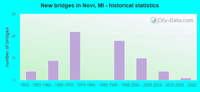
- New bridges - historical statistics
- 41950-1959
- 91960-1969
- 221970-1979
- 181990-1999
- 102000-2009
- 42010-2019
- 12020-2022
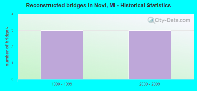
- Reconstructed bridges - Historical Statistics
- 31990-1999
- 32000-2009
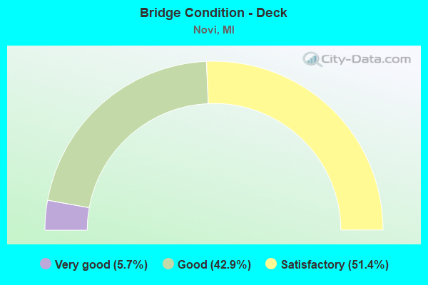
- Bridge Condition - Deck
- 5.7%Very good
- 42.9%Good
- 51.4%Satisfactory
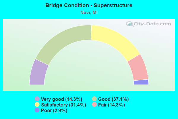
- Bridge Condition - Superstructure
- 14.3%Very good
- 37.1%Good
- 31.4%Satisfactory
- 14.3%Fair
- 2.9%Poor
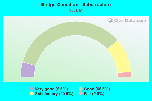
- Bridge Condition - Substructure
- 8.6%Very good
- 68.6%Good
- 20.0%Satisfactory
- 2.9%Fair
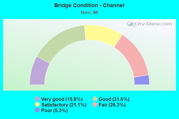
- Bridge Condition - Channel
- 15.8%Very good
- 31.6%Good
- 21.1%Satisfactory
- 26.3%Fair
- 5.3%Poor
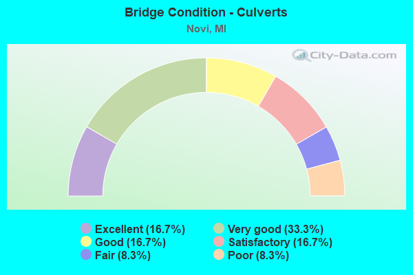
- Bridge Condition - Culverts
- 16.7%Excellent
- 33.3%Very good
- 16.7%Good
- 16.7%Satisfactory
- 8.3%Fair
- 8.3%Poor
Find on map >> Show street view
Structure Number: 13858, Location: 0.3 MI W OF MEADOWBROOK (Lat: 42.452556, Lng: -83.460750), Route carried "on" structure: City street , Year Built: 1965, Status: Open, Structure Length: 0.91m (2.99ft), Average Daily Traffic: 10,700 (year 2014), Average Future Daily Traffic: 12,300 (year 2034), Design Load: H 20, Features Intersected: BISHOP CREEK, Facility Carried by Structure: 9 MILE ROAD
Minimum Vertical Clearance: 30.48m (100.00ft), Kilometerpoint: 7.284, Lanes on structure: 3, Owner: City or Municipal Highway Agency, Approaching Roadway Width: 12.3m (40.4ft), Material/Design: Steel, Design/Construction: Culvert, Number Of Spans In Main Unit: 2, Length of Maximum Span: 3.8m (12.5ft), Curb or Sidewalk Widths: Left: 3.6m (11.8ft), Right: 4.5m (14.8ft), Curb-To-Curb Width: 11.9m (39.0ft), Out-to-Out Width: 20.0m (65.6ft)
Condition: Channel: Good, Culverts: Satisfactory, Operating Rating: 46.7 metric tons, Method Used To Determine Operating Rating: Load and Resistance Factor Rating (LRFR) rating reported by rating factor(RF) method using HL-93 loadings, Inventory Rating: 35.6 metric tons, Method Used To Determine Inventory Rating: Load and Resistance Factor Rating (LRFR) rating reported by rating factor(RF) method using HL-93 loadings, Structural Evaluation: Equal to present minimum criteria, Deck Geometry: High priority of corrective action, Waterway Adequacy: Equal to present desirable criteria, Approach Roadway Alignment: Equal to present minimum criteria, Designated Inspection Frequency: Every 24 months, Inspection Date: September 2020, Wearing Surface/Protective System: Wearing Surface: Bituminous
Find on map >> Show street view
Structure Number: 13859, Location: 500 FT S OF 11 MILE RD (Lat: 42.478000, Lng: -83.534556), Route carried "on" structure: City street , Year Built: 2012, Status: Open, Structure Length: 1.30m (4.27ft), Average Daily Traffic: 2,500 (year 2012), Average Future Daily Traffic: 2,875 (year 2032), Design Load: HS 25 or greater, Features Intersected: UNNAMED TRIB, Facility Carried by Structure: WIXOM RD
Minimum Vertical Clearance: 30.48m (100.00ft), Kilometerpoint: 1.854, Lanes on structure: 2, Owner: City or Municipal Highway Agency, Approaching Roadway Width: 8.5m (27.9ft), Material/Design: Concrete, Design/Construction: Culvert, Number Of Spans In Main Unit: 2, Length of Maximum Span: 6.1m (20.0ft), Curb or Sidewalk Widths: Left: 5.2m (17.1ft), Right: 4.4m (14.4ft), Curb-To-Curb Width: 8.6m (28.2ft), Out-to-Out Width: 18.2m (59.7ft)
Condition: Channel: Good, Culverts: Very good, Operating Rating: 54.6 metric tons, Method Used To Determine Operating Rating: Field evaluation and documented engineering judgment, Inventory Rating: 32.7 metric tons, Method Used To Determine Inventory Rating: Field evaluation and documented engineering judgment, Structural Evaluation: Equal to present desirable criteria, Deck Geometry: Meets minimum limits, Waterway Adequacy: Equal to present desirable criteria, Approach Roadway Alignment: Better than present minimum criteria, Designated Inspection Frequency: Every 24 months, Inspection Date: September 2020, Wearing Surface/Protective System: Wearing Surface: Bituminous
Find on map >> Show street view
Structure Number: 1386, Location: CHASE FARMS SUBDIVISION (Lat: 42.447750, Lng: -83.469222), Route carried "on" structure: City street , Year Built: 2000, Status: Open, Structure Length: 0.79m (2.59ft), Average Daily Traffic: 180 (year 2000), Average Future Daily Traffic: 207 (year 2020), Design Load: HS 25 or greater, Features Intersected: TRIB TO MIDDLE ROUGE RIV, Facility Carried by Structure: ASHBURY DRIVE
Minimum Vertical Clearance: 30.48m (100.00ft), Kilometerpoint: 0.383, Lanes on structure: 2, Owner: City or Municipal Highway Agency, Approaching Roadway Width: 8.2m (26.9ft), Material/Design: Concrete, Design/Construction: Culvert, Number Of Spans In Main Unit: 1, Length of Maximum Span: 7.1m (23.3ft), Curb or Sidewalk Widths: Left: 1.5m (4.9ft), Right: 1.5m (4.9ft), Curb-To-Curb Width: 8.2m (26.9ft), Out-to-Out Width: 14.2m (46.6ft)
Condition: Channel: Fair, Culverts: Good, Operating Rating: 54.6 metric tons, Method Used To Determine Operating Rating: Field evaluation and documented engineering judgment, Inventory Rating: 32.7 metric tons, Method Used To Determine Inventory Rating: Field evaluation and documented engineering judgment, Structural Evaluation: Better than present minimum criteria, Deck Geometry: Somewhat better than minimum adequacy, Waterway Adequacy: Equal to present desirable criteria, Approach Roadway Alignment: Somewhat better than minimum adequacy, Designated Inspection Frequency: Every 24 months, Inspection Date: September 2020, Wearing Surface/Protective System: Wearing Surface: Bituminous
Find on map >> Show street view
Structure Number: 13861, Location: W END OF ISLAND LAKE (Lat: 42.480083, Lng: -83.553694), Route carried "on" structure: City street , Year Built: 1968, Status: Open, Structure Length: 0.79m (2.59ft), Average Daily Traffic: 150 (year 2005), Average Future Daily Traffic: 170 (year 2025), Design Load: Railroad, Features Intersected: NOVI LYONS DRAIN, Facility Carried by Structure: ISLAND LAKE DRIVE
Minimum Vertical Clearance: 30.48m (100.00ft), Kilometerpoint: 2.253, Lanes on structure: 2, Owner: City or Municipal Highway Agency, Approaching Roadway Width: 8.5m (27.9ft), Skew: 1 degrees, Material/Design: Concrete, Design/Construction: Culvert, Number Of Spans In Main Unit: 1, Length of Maximum Span: 7.3m (24.0ft), Curb or Sidewalk Widths: Left: 0.0m, Right: 1.5m (4.9ft), Curb-To-Curb Width: 8.6m (28.2ft), Out-to-Out Width: 26.7m (87.6ft)
Condition: Channel: Good, Culverts: Very good, Operating Rating: 54.6 metric tons, Method Used To Determine Operating Rating: Field evaluation and documented engineering judgment, Inventory Rating: 32.7 metric tons, Method Used To Determine Inventory Rating: Field evaluation and documented engineering judgment, Structural Evaluation: Equal to present desirable criteria, Deck Geometry: Equal to present minimum criteria, Waterway Adequacy: Equal to present desirable criteria, Approach Roadway Alignment: Meets minimum limits, Designated Inspection Frequency: Every 24 months, Inspection Date: September 2020, Wearing Surface/Protective System: Wearing Surface: Bituminous
Find on map >> Show street view
Structure Number: 13862, Location: AT END OF TIMBER TRAIL (Lat: 42.477611, Lng: -83.542139), Route carried "on" structure: City street , Year Built: 1968, Status: Open, Structure Length: 1.48m (4.86ft), Average Daily Traffic: 100 (year 2000), Average Future Daily Traffic: 115 (year 2020), Design Load: HS 25 or greater, Features Intersected: UNNAMED TRIBUTARY, Facility Carried by Structure: SHORELINE DRIVE
Minimum Vertical Clearance: 30.48m (100.00ft), Kilometerpoint: 0.410, Lanes on structure: 2, Owner: City or Municipal Highway Agency, Approaching Roadway Width: 8.5m (27.9ft), Skew: 6 degrees, Material/Design: Concrete, Design/Construction: Culvert, Number Of Spans In Main Unit: 1, Length of Maximum Span: 7.3m (24.0ft), Curb or Sidewalk Widths: Left: 9.5m (31.2ft), Right: 8.9m (29.2ft), Curb-To-Curb Width: 8.4m (27.6ft), Out-to-Out Width: 67.9m (222.8ft)
Condition: Channel: Good, Culverts: Very good, Operating Rating: 54.6 metric tons, Method Used To Determine Operating Rating: Field evaluation and documented engineering judgment, Inventory Rating: 32.7 metric tons, Method Used To Determine Inventory Rating: Field evaluation and documented engineering judgment, Structural Evaluation: Equal to present desirable criteria, Deck Geometry: Equal to present minimum criteria, Waterway Adequacy: Equal to present desirable criteria, Approach Roadway Alignment: Equal to present minimum criteria, Designated Inspection Frequency: Every 24 months, Inspection Date: September 2020, Wearing Surface/Protective System: Wearing Surface: Bituminous
Find on map >> Show street view
Structure Number: 14137, Location: LYON TWP SEC 14/23 (Lat: 42.477222, Lng: -83.592886), Route carried "on" structure: County highway , Year Built: 2021, Status: Open, Structure Length: 0.68m (2.23ft), Average Daily Traffic: 140 (year 2020), Truck Traffic: 3%, Average Future Daily Traffic: 170 (year 2040), Design Load: Greater than HL93, Features Intersected: NOVI-LYON DRAIN, Facility Carried by Structure: 11 MILE RD
Minimum Vertical Clearance: 30.48m (100.00ft), Kilometerpoint: 6.192, Lanes on structure: 2, Owner: County Highway Agency, Approaching Roadway Width: 6.7m (22.0ft), Skew: 1 degrees, Material/Design: Concrete, Design/Construction: Culvert, Number Of Spans In Main Unit: 1, Length of Maximum Span: 6.8m (22.3ft), Curb-To-Curb Width: 6.7m (22.0ft), Out-to-Out Width: 14.6m (47.9ft)
Condition: Channel: Good, Culverts: Excellent, Operating Rating: 70.0 metric tons, Method Used To Determine Operating Rating: Load and Resistance Factor Rating (LRFR) rating reported by rating factor(RF) method using HL-93 loadings, Inventory Rating: 55.1 metric tons, Method Used To Determine Inventory Rating: Load and Resistance Factor Rating (LRFR) rating reported by rating factor(RF) method using HL-93 loadings, Structural Evaluation: Superior to present desirable criteria, Deck Geometry: Meets minimum limits, Waterway Adequacy: Equal to present minimum criteria, Approach Roadway Alignment: Equal to present desirable criteria, Designated Inspection Frequency: Every 6 months, Inspection Date: December 2021, Wearing Surface/Protective System: Wearing Surface: Gravel
Find on map >> Show street view
Structure Number: 14274, Location: 0.5 MI W OF NOVI RD (Lat: 42.451858, Lng: -83.484103), Route carried "on" structure: City street , Year Built: 1970, Status: Open, Structure Length: 0.81m (2.66ft), Average Daily Traffic: 8,260 (year 2014), Average Future Daily Traffic: 9,500 (year 2034), Features Intersected: THORNTON CREEK, Facility Carried by Structure: 9 MILE ROAD
Minimum Vertical Clearance: 30.48m (100.00ft), Kilometerpoint: 9.172, Lanes on structure: 2, Owner: City or Municipal Highway Agency, Approaching Roadway Width: 7.3m (24.0ft), Skew: 6 degrees, Material/Design: Steel, Design/Construction: Culvert, Number Of Spans In Main Unit: 2, Length of Maximum Span: 3.7m (12.1ft)
Condition: Channel: Satisfactory, Culverts: Poor, Operating Rating: 65.8 metric tons, Method Used To Determine Operating Rating: Load Factor (LF) rating reported by rating factor (RF) method using MS18 loading, Inventory Rating: 39.5 metric tons, Method Used To Determine Inventory Rating: Load Factor (LF) rating reported by rating factor (RF) method using MS18 loading, Structural Evaluation: Meets minimum limits, Waterway Adequacy: Equal to present minimum criteria, Approach Roadway Alignment: Meets minimum limits, Designated Inspection Frequency: Every 12 months, Inspection Date: September 2021, Wearing Surface/Protective System: Wearing Surface: Bituminous
Find on map >> Show street view
Structure Number: 14275, Location: 0.06 MI E OF NOVI RD (Lat: 42.452169, Lng: -83.472922), Route carried "on" structure: City street , Year Built: 1990, Status: Open, Structure Length: 0.66m (2.17ft), Average Daily Traffic: 11,126 (year 2012), Average Future Daily Traffic: 12,800 (year 2032), Design Load: HS 20, Features Intersected: THORNTON CREEK, Facility Carried by Structure: 9 MILE ROAD
Minimum Vertical Clearance: 30.48m (100.00ft), Kilometerpoint: 8.293, Lanes on structure: 4, Owner: City or Municipal Highway Agency, Approaching Roadway Width: 15.8m (51.8ft), Material/Design: Steel, Design/Construction: Culvert, Number Of Spans In Main Unit: 2, Length of Maximum Span: 3.0m (9.8ft), Curb or Sidewalk Widths: Left: 0.0m, Right: 2.4m (7.9ft), Curb-To-Curb Width: 15.8m (51.8ft), Out-to-Out Width: 31.7m (104.0ft)
Condition: Channel: Fair, Culverts: Good, Operating Rating: 97.2 metric tons, Method Used To Determine Operating Rating: Load Factor (LF) rating reported by rating factor (RF) method using MS18 loading, Inventory Rating: 69.7 metric tons, Method Used To Determine Inventory Rating: Load Factor (LF) rating reported by rating factor (RF) method using MS18 loading, Structural Evaluation: Better than present minimum criteria, Deck Geometry: Meets minimum limits, Waterway Adequacy: Equal to present desirable criteria, Approach Roadway Alignment: Equal to present minimum criteria, Designated Inspection Frequency: Every 24 months, Inspection Date: September 2020, Wearing Surface/Protective System: Wearing Surface: Bituminous
Find on map >> Show street view
Structure Number: 7802, Location: IN NOVI (Lat: 42.493592, Lng: -83.515822), Route carried "under" structure: Interstate 96, Year Built: 2003, Structure Length: 0. m, Average Daily Traffic: 132,600 (year 2007), Truck Traffic: 7%, Features Intersected: I-96, Facility Carried by Structure: BECK RD
Minimum Vertical Clearance: 5.23m (17.16ft), Kilometerpoint: 13.290, Lanes on structure: 4, Lanes under structure: 6, Material/Design: Prestressed concrete, Design/Construction: Stringer/Multi-beam, Length of Maximum Span: 29.7m (97.4ft)
Find on map >> Show street view
Structure Number: 7803, Location: IN NOVI (Lat: 42.487086, Lng: -83.475825), Route carried "under" structure: Interstate 96, Year Built: 1979, Structure Length: 0. m, Average Daily Traffic: 160,679 (year 2018), Truck Traffic: 6%, Features Intersected: I-96, Facility Carried by Structure: NOVI RD
Minimum Vertical Clearance: 5.41m (17.75ft), Kilometerpoint: 16.693, Lanes on structure: 6, Lanes under structure: 8, Material/Design: Steel, Design/Construction: Stringer/Multi-beam, Length of Maximum Span: 35.1m (115.2ft)
Find on map >> Show street view
Structure Number: 7804, Location: E LTS OF NOVI (Lat: 42.480564, Lng: -83.435503), Route carried "under" structure: State highway 5, Year Built: 1957, Structure Length: 0. m, Average Daily Traffic: 32,868 (year 2007), Truck Traffic: 2%, Features Intersected: M-5, Facility Carried by Structure: HAGGERTY RD
Minimum Vertical Clearance: 4.57m (14.99ft), Kilometerpoint: 20.111, Lanes on structure: 2, Lanes under structure: 4, Material/Design: Steel, Design/Construction: Stringer/Multi-beam, Length of Maximum Span: 22.3m (73.2ft)
Find on map >> Show street view
Structure Number: 7898, Location: @I-96 (I-696 EB) (Lat: 42.483019, Lng: -83.439344), Route carried "under" structure: Interstate 696, Year Built: 2008, Structure Length: 0. m, Average Daily Traffic: 29,000 (year 2007), Truck Traffic: 17%, Features Intersected: I-696 EB, Facility Carried by Structure: M-5 (OLD M-102)
Minimum Vertical Clearance: 5.13m (16.83ft), Kilometerpoint: 0.488, Lanes on structure: 2, Lanes under structure: 2, Material/Design: Steel continuous, Design/Construction: Stringer/Multi-beam, Length of Maximum Span: 46.9m (153.9ft)
Find on map >> Show street view
Structure Number: 8115, Location: IN THE VILLAGE OF NOVI (Lat: 42.485047, Lng: -83.455997), Route carried "under" structure: Interstate 96, Year Built: 1972, Structure Length: 0. m, Average Daily Traffic: 179,634 (year 2007), Truck Traffic: 12%, Features Intersected: I-96, Facility Carried by Structure: MEADOWBROOK RD
Minimum Vertical Clearance: 5.41m (17.75ft), Kilometerpoint: 18.333, Lanes on structure: 2, Lanes under structure: 9, Material/Design: Steel, Design/Construction: Stringer/Multi-beam, Length of Maximum Span: 46.8m (153.5ft)
Find on map >> Show street view
Structure Number: 8116, Location: E LTS OF NOVI (Lat: 42.478864, Lng: -83.435428), Route carried "under" structure: Interstate 96, Year Built: 1972, Structure Length: 0. m, Average Daily Traffic: 89,817 (year 2007), Truck Traffic: 8%, Features Intersected: I-96 EB, Facility Carried by Structure: HAGGERTY RD
Minimum Vertical Clearance: 5.69m (18.67ft), Kilometerpoint: 1.915, Lanes on structure: 2, Lanes under structure: 3, Material/Design: Steel, Design/Construction: Stringer/Multi-beam, Length of Maximum Span: 40.8m (133.9ft)
Find on map >> Show street view
Structure Number: 8117, Location: E LTS OF NOVI (Lat: 42.486025, Lng: -83.435761), Route carried "under" structure: Interstate 96, Year Built: 1971, Structure Length: 0. m, Average Daily Traffic: 89,817 (year 2007), Truck Traffic: 8%, Features Intersected: I-96 WB, Facility Carried by Structure: HAGGERTY RD
Minimum Vertical Clearance: 5.41m (17.75ft), Kilometerpoint: 0.958, Lanes on structure: 2, Lanes under structure: 4, Material/Design: Steel, Design/Construction: Stringer/Multi-beam, Length of Maximum Span: 29.2m (95.8ft)
Find on map >> Show street view
Structure Number: 8118, Location: @ I-96/I-696 INTERCHANGE (Lat: 42.479428, Lng: -83.432058), Route carried "under" structure: State highway 102, Year Built: 1971, Structure Length: 0. m, Average Daily Traffic: 32,000 (year 1995), Truck Traffic: 3%, Features Intersected: M-5, Facility Carried by Structure: I-696 W TO I-275 S
Minimum Vertical Clearance: 5.11m (16.77ft), Kilometerpoint: 1.777, Lanes on structure: 3, Lanes under structure: 7, Material/Design: Steel, Design/Construction: Stringer/Multi-beam, Length of Maximum Span: 34.5m (113.2ft)
Find on map >> Show street view
Structure Number: 8119, Location: @ I-96/I-696 INTERCHANGE (Lat: 42.485197, Lng: -83.431444), Route carried "under" structure: Interstate 696, Year Built: 1971, Structure Length: 0. m, Average Daily Traffic: 58,000 (year 2007), Truck Traffic: 17%, Features Intersected: I-696, Facility Carried by Structure: I-275 NB & M-5 WB
Minimum Vertical Clearance: 5.33m (17.49ft), Kilometerpoint: 1.193, Lanes on structure: 2, Lanes under structure: 4, Material/Design: Steel, Design/Construction: Stringer/Multi-beam, Length of Maximum Span: 28.5m (93.5ft)
Find on map >> Show street view
Structure Number: 812, Location: @ I-96/I-696 INTERCHANGE (Lat: 42.485072, Lng: -83.431714), Route carried "under" structure: Interstate 696, Year Built: 1971, Structure Length: 0. m, Average Daily Traffic: 58,000 (year 2007), Truck Traffic: 17%, Features Intersected: I-696, Facility Carried by Structure: I-96 WB
Minimum Vertical Clearance: 5.00m (16.40ft), Kilometerpoint: 1.165, Lanes on structure: 2, Lanes under structure: 4, Material/Design: Steel, Design/Construction: Stringer/Multi-beam, Length of Maximum Span: 28.5m (93.5ft)
Find on map >> Show street view
Structure Number: 8121, Location: I-96 & I-696 INTERCHANGE (Lat: 42.485133, Lng: -83.431856), Route carried "under" structure: Interstate 96, Year Built: 1972, Structure Length: 0. m, Average Daily Traffic: 58,000 (year 2007), Truck Traffic: 17%, Features Intersected: I-96 & I-275
Minimum Vertical Clearance: 5.36m (17.59ft), Kilometerpoint: 1.148, Lanes on structure: 2, Lanes under structure: 3, Material/Design: Steel, Design/Construction: Stringer/Multi-beam, Length of Maximum Span: 49.9m (163.7ft)
Find on map >> Show street view
Structure Number: 8122, Location: @ I-96/I-696 INTERCHANGE (Lat: 42.478383, Lng: -83.428128), Route carried "under" structure: State highway 5, Year Built: 1971, Structure Length: 0. m, Average Daily Traffic: 32,868 (year 2007), Truck Traffic: 2%, Features Intersected: M-5, Facility Carried by Structure: I-96 WB
Minimum Vertical Clearance: 5.21m (17.09ft), Kilometerpoint: 20.768, Lanes on structure: 2, Lanes under structure: 6, Material/Design: Steel, Design/Construction: Stringer/Multi-beam, Length of Maximum Span: 31.5m (103.3ft)
Find on map >> Show street view
Structure Number: 8133, Location: I-96,I-696,M-5 INTRCHG (Lat: 42.496694, Lng: -83.446264), Route carried "under" structure: County highway , Year Built: 1993, Structure Length: 0. m, Average Daily Traffic: 53,200 (year 1992), Truck Traffic: 4%, Features Intersected: 12 MILE RD, Facility Carried by Structure: M-5 NB MAINLINE
Minimum Vertical Clearance: 5.46m (17.91ft), Kilometerpoint: 3.533, Lanes on structure: 3, Lanes under structure: 8, Material/Design: Prestressed concrete, Design/Construction: Stringer/Multi-beam, Length of Maximum Span: 31.7m (104.0ft)
Find on map >> Show street view
Structure Number: 8134, Location: I-96,I-696 M-5 INTRCHG (Lat: 42.496672, Lng: -83.446686), Route carried "under" structure: County highway , Year Built: 1993, Structure Length: 0. m, Average Daily Traffic: 53,200 (year 1992), Truck Traffic: 4%, Features Intersected: 12 MILE ROAD, Facility Carried by Structure: M-5 SB MAINLINE
Minimum Vertical Clearance: 5.46m (17.91ft), Kilometerpoint: 3.497, Lanes on structure: 3, Lanes under structure: 4, Material/Design: Prestressed concrete, Design/Construction: Stringer/Multi-beam, Length of Maximum Span: 31.7m (104.0ft)
Find on map >> Show street view
Structure Number: 8135, Location: I-96, I-696, M-5 INTRCHG (Lat: 42.496708, Lng: -83.445889), Route carried "under" structure: County highway , Year Built: 1993, Structure Length: 0. m, Average Daily Traffic: 53,200 (year 1992), Truck Traffic: 4%, Features Intersected: 12 MILE RD, Facility Carried by Structure: M-5 NB CD
Minimum Vertical Clearance: 5.66m (18.57ft), Kilometerpoint: 3.563, Lanes on structure: 3, Lanes under structure: 8, Material/Design: Prestressed concrete, Design/Construction: Stringer/Multi-beam, Length of Maximum Span: 31.7m (104.0ft)
Find on map >> Show street view
Structure Number: 8136, Location: I-96,I696,M-5 INTRCHG (Lat: 42.496661, Lng: -83.447039), Route carried "under" structure: County highway , Year Built: 1993, Structure Length: 0. m, Average Daily Traffic: 53,200 (year 1992), Truck Traffic: 4%, Features Intersected: 12 MILE RD, Facility Carried by Structure: M-5 S BD CD
Minimum Vertical Clearance: 5.36m (17.59ft), Kilometerpoint: 3.468, Lanes on structure: 3, Lanes under structure: 8, Material/Design: Prestressed concrete, Design/Construction: Stringer/Multi-beam, Length of Maximum Span: 31.7m (104.0ft)
Find on map >> Show street view
Structure Number: 1294, Location: NOVI TWP SEC 13 (Lat: 42.484200, Lng: -83.448111), Route carried "under" structure: State highway 5, Year Built: 1992, Structure Length: 0. m, Average Daily Traffic: 36,200 (year 2003), Truck Traffic: 10%, Features Intersected: M-5 SB / I-96 / I-697, Facility Carried by Structure: I-96 EB, RAMP J
Minimum Vertical Clearance: 5.46m (17.91ft), Kilometerpoint: 7.994, Lanes on structure: 2, Lanes under structure: 2, Material/Design: Steel, Design/Construction: Stringer/Multi-beam, Length of Maximum Span: 47.5m (155.8ft)
Find on map >> Show street view
Structure Number: 1294, Location: NOVI TWP SEC 13 (Lat: 42.484200, Lng: -83.448111), Route carried "under" structure: Interstate 696, Year Built: 1992, Structure Length: 0. m, Average Daily Traffic: 171,000 (year 2003), Truck Traffic: 10%, Features Intersected: M-5 SB / I-96 / I-697, Facility Carried by Structure: I-96 EB, RAMP J
Minimum Vertical Clearance: 6.20m (20.34ft), Kilometerpoint: 7.984, Lanes on structure: 2, Lanes under structure: 6, Material/Design: Steel, Design/Construction: Stringer/Multi-beam, Length of Maximum Span: 47.5m (155.8ft)
Find on map >> Show street view
Structure Number: 1294, Location: NOVI TWP SEC 13 (Lat: 42.484200, Lng: -83.448111), Route carried "under" structure: Interstate 96, Year Built: 1992, Structure Length: 0. m, Average Daily Traffic: 160,000 (year 2003), Truck Traffic: 10%, Features Intersected: M-5 SB / I-96 / I-697
Minimum Vertical Clearance: 13.72m (45.01ft), Kilometerpoint: 0.000, Lanes on structure: 2, Lanes under structure: 4, Material/Design: Steel, Design/Construction: Stringer/Multi-beam, Length of Maximum Span: 47.5m (155.8ft)
Find on map >> Show street view
Structure Number: 12941, Location: NOVI TWP SEC 13 (Lat: 42.484600, Lng: -83.448056), Route carried "under" structure: Interstate 96, Year Built: 1992, Structure Length: 0. m, Average Daily Traffic: 99,536 (year 2007), Truck Traffic: 13%, Features Intersected: I-96/I-696, Facility Carried by Structure: M-5
Minimum Vertical Clearance: 5.33m (17.49ft), Kilometerpoint: 19.012, Lanes on structure: 3, Lanes under structure: 5, Material/Design: Steel, Design/Construction: Stringer/Multi-beam, Length of Maximum Span: 52.4m (171.9ft)
Find on map >> Show street view
Structure Number: 12942, Location: NOVI TWP SEC 13 (Lat: 42.488258, Lng: -83.445650), Route carried "under" structure: State highway 5, Year Built: 2000, Structure Length: 0. m, Average Daily Traffic: 26,761 (year 2007), Truck Traffic: 1%, Features Intersected: M-5 NB, Facility Carried by Structure: I-96 EB, RAMP J
Minimum Vertical Clearance: 5.92m (19.42ft), Kilometerpoint: 7.561, Lanes on structure: 2, Lanes under structure: 3, Material/Design: Steel, Design/Construction: Stringer/Multi-beam, Length of Maximum Span: 56.5m (185.4ft)