Bridge Statistics for Omaha, Nebraska (NE)
Condition, Traffic, Stress, Structural Evaluation, Project Costs
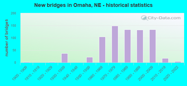
- New bridges - historical statistics
- 21900-1909
- 21920-1929
- 371930-1939
- 221950-1959
- 1051960-1969
- 1491970-1979
- 1341980-1989
- 1321990-1999
- 1342000-2009
- 182010-2019
- 52020-2022
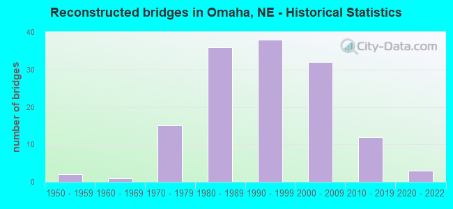
- Reconstructed bridges - Historical Statistics
- 21950-1959
- 11960-1969
- 151970-1979
- 361980-1989
- 381990-1999
- 322000-2009
- 122010-2019
- 32020-2022
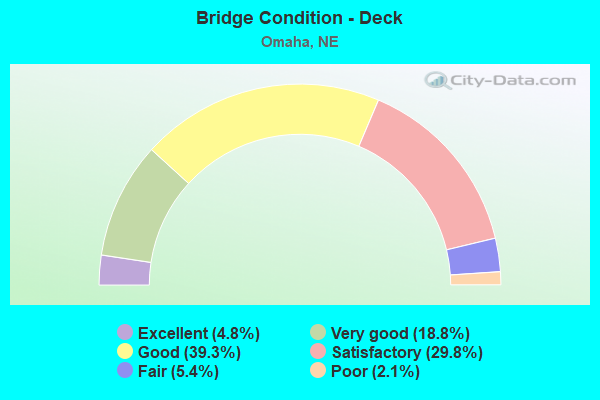
- Bridge Condition - Deck
- 4.8%Excellent
- 18.8%Very good
- 39.3%Good
- 29.8%Satisfactory
- 5.4%Fair
- 2.1%Poor
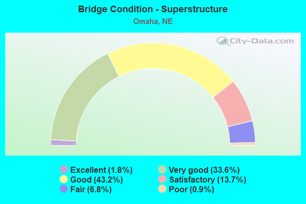
- Bridge Condition - Superstructure
- 1.8%Excellent
- 33.6%Very good
- 43.2%Good
- 13.7%Satisfactory
- 6.8%Fair
- 0.9%Poor
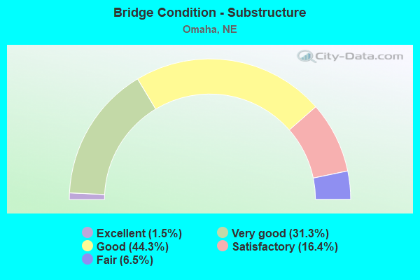
- Bridge Condition - Substructure
- 1.5%Excellent
- 31.3%Very good
- 44.3%Good
- 16.4%Satisfactory
- 6.5%Fair

- Bridge Condition - Channel
- 1.3%Excellent
- 20.6%Very good
- 39.1%Good
- 25.3%Satisfactory
- 11.2%Fair
- 2.6%Poor
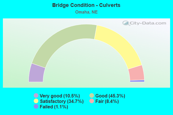
- Bridge Condition - Culverts
- 10.5%Very good
- 45.3%Good
- 34.7%Satisfactory
- 8.4%Fair
- 1.1%Failed
Find on map >> Show street view
Structure Number: S075 09106, Location: US75/N64 INTERCHG (Lat: 41.267300, Lng: -95.952900), Route carried "under" structure: US 75, Year Built: 2009, Structure Length: 0. m, Average Daily Traffic: 2,515 (year 2006), Features Intersected: N64
Minimum Vertical Clearance: 4.54m (14.90ft), Kilometerpoint: 14.655, Lanes on structure: 6, Lanes under structure: 6, Material/Design: Prestressed concrete continuous, Design/Construction: Stringer/Multi-beam, Length of Maximum Span: 38.4m (126.0ft)
Find on map >> Show street view
Structure Number: S075 09106, Location: US75/N64 INTERCHG (Lat: 41.267300, Lng: -95.952900), Route carried "under" structure: US 64, Year Built: 2009, Structure Length: 0. m, Average Daily Traffic: 2,515 (year 2006), Features Intersected: N64, Facility Carried by Structure: SB-US75
Minimum Vertical Clearance: 4.54m (14.90ft), Kilometerpoint: 14.655, Lanes on structure: 6, Lanes under structure: 6, Material/Design: Prestressed concrete continuous, Design/Construction: Stringer/Multi-beam, Length of Maximum Span: 38.4m (126.0ft)
Find on map >> Show street view
Structure Number: S075 09109L, Location: US75/N64 INTERCHG (Lat: 41.267900, Lng: -95.952400), Route carried "under" structure: State highway 64, Year Built: 2007, Structure Length: 0. m, Average Daily Traffic: 19,435 (year 2012), Truck Traffic: 3%, Features Intersected: N64 /CUMING ST, Facility Carried by Structure: SB US75 OVER CUMIN
Minimum Vertical Clearance: 4.70m (15.42ft), Kilometerpoint: 12.664, Lanes on structure: 3, Lanes under structure: 3, Material/Design: Prestressed concrete continuous, Design/Construction: Tee Beam, Length of Maximum Span: 22.6m (74.1ft)
Find on map >> Show street view
Structure Number: S075 09109R, Location: US75/N64 INTERCHG (Lat: 41.267900, Lng: -95.952200), Route carried "under" structure: State highway 64, Year Built: 2005, Structure Length: 0. m, Average Daily Traffic: 19,435 (year 2012), Truck Traffic: 3%, Features Intersected: N64R/CUMING ST, Facility Carried by Structure: NB-US75
Minimum Vertical Clearance: 4.70m (15.42ft), Kilometerpoint: 12.664, Lanes on structure: 3, Lanes under structure: 3, Material/Design: Prestressed concrete continuous, Design/Construction: Tee Beam, Length of Maximum Span: 22.6m (74.1ft)
Find on map >> Show street view
Structure Number: S075 09137, Location: HAMILTON ST INTRCHG (Lat: 41.271900, Lng: -95.952400), Route carried "under" structure: US 75, Year Built: 1977, Structure Length: 0. m, Average Daily Traffic: 51,140 (year 2012), Truck Traffic: 4%, Features Intersected: US75, Facility Carried by Structure: HAMILTN ST/FAU5066
Minimum Vertical Clearance: 6.57m (21.56ft), Kilometerpoint: 14.704, Lanes on structure: 6, Lanes under structure: 6, Material/Design: Steel continuous, Design/Construction: Stringer/Multi-beam, Length of Maximum Span: 34.1m (111.9ft)
Find on map >> Show street view
Structure Number: S075 09169, Location: IN OMAHA (Lat: 41.276500, Lng: -95.952500), Route carried "under" structure: US 75, Year Built: 1977, Structure Length: 0. m, Average Daily Traffic: 51,140 (year 2012), Truck Traffic: 4%, Features Intersected: US75, Facility Carried by Structure: PARKER ST
Minimum Vertical Clearance: 4.95m (16.24ft), Kilometerpoint: 14.756, Lanes on structure: 6, Lanes under structure: 6, Material/Design: Steel continuous, Design/Construction: Stringer/Multi-beam, Length of Maximum Span: 25.9m (85.0ft)
Find on map >> Show street view
Structure Number: S075 09202, Location: LAKE ST INTRCHG (Lat: 41.281500, Lng: -95.952400), Route carried "under" structure: US 75, Year Built: 1982, Structure Length: 0. m, Average Daily Traffic: 51,160 (year 2012), Truck Traffic: 4%, Features Intersected: US75, Facility Carried by Structure: LAKE ST/FAU 5068
Minimum Vertical Clearance: 6.19m (20.31ft), Kilometerpoint: 14.809, Lanes on structure: 6, Lanes under structure: 6, Material/Design: Steel continuous, Design/Construction: Stringer/Multi-beam, Length of Maximum Span: 34.1m (111.9ft)
Find on map >> Show street view
Structure Number: S075 09233, Location: OMAHA US75 & BINNEY ST (Lat: 41.286000, Lng: -95.952300), Route carried "under" structure: US 75, Year Built: 1985, Structure Length: 0. m, Average Daily Traffic: 51,160 (year 2012), Truck Traffic: 4%, Features Intersected: US75, Facility Carried by Structure: BINNEY ST
Minimum Vertical Clearance: 5.20m (17.06ft), Kilometerpoint: 14.859, Lanes on structure: 6, Lanes under structure: 6, Material/Design: Steel continuous, Design/Construction: Stringer/Multi-beam, Length of Maximum Span: 29.9m (98.1ft)
Find on map >> Show street view
Structure Number: S075 09255, Location: OMAHA BRISTOL @ US75 (Lat: 41.289200, Lng: -95.952400), Route carried "under" structure: US 75, Year Built: 1984, Structure Length: 0. m, Average Daily Traffic: 51,160 (year 2012), Truck Traffic: 4%, Features Intersected: US75, Facility Carried by Structure: BRISTOL ST
Minimum Vertical Clearance: 5.05m (16.57ft), Kilometerpoint: 14.894, Lanes on structure: 6, Lanes under structure: 6, Material/Design: Steel continuous, Design/Construction: Stringer/Multi-beam, Length of Maximum Span: 29.0m (95.1ft)
Find on map >> Show street view
Structure Number: S075 0928, Location: US75 @ MANDERSON OMAHA (Lat: 41.292600, Lng: -95.952300), Route carried "under" structure: US 75, Year Built: 1986, Structure Length: 0. m, Average Daily Traffic: 51,165 (year 2008), Truck Traffic: 4%, Features Intersected: HWY 75, Facility Carried by Structure: PEDESTRIAN OVRPASS
Minimum Vertical Clearance: 5.30m (17.39ft), Kilometerpoint: 14.932, Lanes on structure: 6, Lanes under structure: 6, Material/Design: Steel, Design/Construction: Stringer/Multi-beam, Length of Maximum Span: 28.3m (92.8ft)
Find on map >> Show street view
Structure Number: S075 09302, Location: SPRAGUE @ US75 OMAHA (Lat: 41.296000, Lng: -95.952200), Route carried "under" structure: US 75, Year Built: 1986, Structure Length: 0. m, Average Daily Traffic: 51,160 (year 2012), Truck Traffic: 4%, Features Intersected: US75, Facility Carried by Structure: SPRAGUE ST/FAU507
Minimum Vertical Clearance: 5.10m (16.73ft), Kilometerpoint: 14.970, Lanes on structure: 6, Lanes under structure: 6, Material/Design: Steel continuous, Design/Construction: Stringer/Multi-beam, Length of Maximum Span: 32.0m (105.0ft)
Find on map >> Show street view
Structure Number: S075 09327, Location: AMES AVE/STORZ EXP INTCHG (Lat: 41.299600, Lng: -95.951800), Route carried "under" structure: US 75, Year Built: 1984, Structure Length: 0. m, Average Daily Traffic: 51,160 (year 2012), Truck Traffic: 4%, Features Intersected: US75, Facility Carried by Structure: AMES AVE/FAU 5080
Minimum Vertical Clearance: 5.53m (18.14ft), Kilometerpoint: 15.010, Lanes on structure: 5, Lanes under structure: 5, Material/Design: Steel continuous, Design/Construction: Stringer/Multi-beam, Length of Maximum Span: 45.1m (148.0ft)
Find on map >> Show street view
Structure Number: S075 09341, Location: AMES AVE/STORZ EXP INTCHG (Lat: 41.301600, Lng: -95.952400), Route carried "under" structure: US 75, Year Built: 1986, Structure Length: 0. m, Average Daily Traffic: 51,160 (year 2012), Truck Traffic: 4%, Features Intersected: NB-US75, Facility Carried by Structure: SB-STORZ EXP
Minimum Vertical Clearance: 5.28m (17.32ft), Kilometerpoint: 15.033, Lanes on structure: 2, Lanes under structure: 2, Material/Design: Steel continuous, Design/Construction: Stringer/Multi-beam, Length of Maximum Span: 25.3m (83.0ft)
Find on map >> Show street view
Structure Number: S075 09354A, Location: AMES AVE/STORZ EXP INTCHG (Lat: 41.302900, Lng: -95.951700), Route carried "under" structure: City street 5098, Year Built: 1986, Structure Length: 0. m, Average Daily Traffic: 1,440 (year 2010), Features Intersected: EB-HARTMAN CONN/FAU 5098, Facility Carried by Structure: SB-STORZ EXP
Minimum Vertical Clearance: 5.25m (17.22ft), Kilometerpoint: 16.135, Lanes on structure: 2, Lanes under structure: 2, Material/Design: Steel continuous, Design/Construction: Stringer/Multi-beam, Length of Maximum Span: 22.3m (73.2ft)
Find on map >> Show street view
Structure Number: S080 44459, Location: IN OMAHA (Lat: 41.205300, Lng: -96.094000), Route carried "under" structure: Interstate 80, Year Built: 1959, Structure Length: 0. m, Average Daily Traffic: 82,755 (year 2013), Truck Traffic: 12%, Features Intersected: I80, Facility Carried by Structure: Q ST/FAU 5026
Minimum Vertical Clearance: 5.81m (19.06ft), Kilometerpoint: 71.550, Lanes on structure: 6, Lanes under structure: 6, Material/Design: Steel continuous, Design/Construction: Stringer/Multi-beam, Length of Maximum Span: 50.0m (164.0ft)
Find on map >> Show street view
Structure Number: S080 44507, Location: I & L ST INTRCHG (Lat: 41.211900, Lng: -96.091400), Route carried "under" structure: Interstate 80, Year Built: 1959, Structure Length: 0. m, Average Daily Traffic: 132,690 (year 2013), Truck Traffic: 8%, Features Intersected: I80, Facility Carried by Structure: EB-US275/N92
Minimum Vertical Clearance: 4.77m (15.65ft), Kilometerpoint: 71.627, Lanes on structure: 6, Lanes under structure: 6, Material/Design: Steel continuous, Design/Construction: Stringer/Multi-beam, Length of Maximum Span: 25.9m (85.0ft)
Find on map >> Show street view
Structure Number: S080 44508, Location: I & L ST INTRCHG (Lat: 41.212100, Lng: -96.091300), Route carried "under" structure: Interstate 80, Year Built: 1959, Structure Length: 0. m, Average Daily Traffic: 132,690 (year 2013), Truck Traffic: 8%, Features Intersected: I80, Facility Carried by Structure: WB-US275/N92
Minimum Vertical Clearance: 5.08m (16.67ft), Kilometerpoint: 71.629, Lanes on structure: 6, Lanes under structure: 6, Material/Design: Steel continuous, Design/Construction: Stringer/Multi-beam, Length of Maximum Span: 25.9m (85.0ft)
Find on map >> Show street view
Structure Number: S080 44537, Location: IN OMAHA (Lat: 41.216200, Lng: -96.090900), Route carried "under" structure: Interstate 80, Year Built: 1959, Structure Length: 0. m, Average Daily Traffic: 138,715 (year 2013), Truck Traffic: 7%, Features Intersected: I80, Facility Carried by Structure: I ST/FAU 5028
Minimum Vertical Clearance: 5.81m (19.06ft), Kilometerpoint: 71.675, Lanes on structure: 6, Lanes under structure: 6, Material/Design: Steel continuous, Design/Construction: Stringer/Multi-beam, Length of Maximum Span: 29.6m (97.1ft)
Find on map >> Show street view
Structure Number: S080 44602, Location: IN OMAHA (Lat: 41.225100, Lng: -96.087400), Route carried "under" structure: Ramp Interstate 80, Year Built: 1996, Structure Length: 0. m, Average Daily Traffic: 1,500 (year 2003), Features Intersected: SB-CD EAST-RMPS 5-10-11, Facility Carried by Structure: WB-CD ROAD BRG #8
Minimum Vertical Clearance: 5.02m (16.47ft), Kilometerpoint: 71.780, Lanes on structure: 8, Lanes under structure: 8, Material/Design: Steel continuous, Design/Construction: Stringer/Multi-beam, Length of Maximum Span: 55.5m (182.1ft)
Find on map >> Show street view
Structure Number: S080 44602, Location: IN OMAHA (Lat: 41.225100, Lng: -96.087400), Route carried "under" structure: Ramp Interstate 80, Year Built: 1996, Structure Length: 0. m, Average Daily Traffic: 1,500 (year 2003), Features Intersected: SB-CD EAST-RMPS 5-10-11, Facility Carried by Structure: WB-CD ROAD BRG #8
Minimum Vertical Clearance: 6.09m (19.98ft), Kilometerpoint: 71.780, Lanes on structure: 8, Lanes under structure: 8, Material/Design: Steel continuous, Design/Construction: Stringer/Multi-beam, Length of Maximum Span: 55.5m (182.1ft)
Find on map >> Show street view
Structure Number: S080 44602, Location: IN OMAHA (Lat: 41.225100, Lng: -96.087400), Route carried "under" structure: Ramp Interstate 80, Year Built: 1996, Structure Length: 0. m, Average Daily Traffic: 1,500 (year 2003), Features Intersected: SB-CD EAST-RMPS 5-10-11, Facility Carried by Structure: WB-CD ROAD BRG #8
Minimum Vertical Clearance: 10.36m (33.99ft), Kilometerpoint: 71.780, Lanes on structure: 8, Lanes under structure: 8, Material/Design: Steel continuous, Design/Construction: Stringer/Multi-beam, Length of Maximum Span: 55.5m (182.1ft)
Find on map >> Show street view
Structure Number: S080 44602, Location: IN OMAHA (Lat: 41.225100, Lng: -96.087400), Route carried "under" structure: Ramp Interstate 80, Year Built: 1996, Structure Length: 0. m, Average Daily Traffic: 1,500 (year 2003), Features Intersected: SB-CD EAST-RMPS 5-10-11, Facility Carried by Structure: WB-CD ROAD BRG #8
Minimum Vertical Clearance: 5.48m (17.98ft), Kilometerpoint: 71.780, Lanes on structure: 8, Lanes under structure: 8, Material/Design: Steel continuous, Design/Construction: Stringer/Multi-beam, Length of Maximum Span: 55.5m (182.1ft)
Find on map >> Show street view
Structure Number: S080 44606L, Location: IN OMAHA (Lat: 41.224300, Lng: -96.086100), Route carried "under" structure: Ramp Interstate 80, Year Built: 1995, Structure Length: 0. m, Average Daily Traffic: 1,500 (year 2007), Features Intersected: SB-CD EAST & RAMP 10
Minimum Vertical Clearance: 5.20m (17.06ft), Kilometerpoint: 71.786, Lanes on structure: 4, Lanes under structure: 4, Material/Design: Steel continuous, Design/Construction: Stringer/Multi-beam, Length of Maximum Span: 36.6m (120.1ft)
Find on map >> Show street view
Structure Number: S080 44606R, Location: IN OMAHA (Lat: 41.224200, Lng: -96.086000), Route carried "under" structure: Ramp Interstate 80, Year Built: 1995, Structure Length: 0. m, Average Daily Traffic: 1,500 (year 2007), Features Intersected: SB-CD EAST & RAMP #10
Minimum Vertical Clearance: 5.20m (17.06ft), Kilometerpoint: 71.786, Lanes on structure: 4, Lanes under structure: 4, Material/Design: Steel continuous, Design/Construction: Stringer/Multi-beam, Length of Maximum Span: 36.6m (120.1ft)
Find on map >> Show street view
Structure Number: S080 44625, Location: IN OMAHA (Lat: 41.223800, Lng: -96.081500), Route carried "under" structure: Ramp City street 5011, Year Built: 1994, Structure Length: 0. m, Average Daily Traffic: 150,450 (year 2006), Features Intersected: EB-CD/RP10/I80/RP11/WBCD
Minimum Vertical Clearance: 5.33m (17.49ft), Kilometerpoint: 16.462, Lanes on structure: 12, Lanes under structure: 12, Material/Design: Steel continuous, Design/Construction: Stringer/Multi-beam, Length of Maximum Span: 48.8m (160.1ft)
Find on map >> Show street view
Structure Number: S080 44625, Location: IN OMAHA (Lat: 41.223800, Lng: -96.081500), Route carried "under" structure: Ramp City street 5011, Year Built: 1994, Structure Length: 0. m, Average Daily Traffic: 150,450 (year 2006), Features Intersected: EB-CD/RP10/I80/RP11/WBCD
Minimum Vertical Clearance: 5.94m (19.49ft), Kilometerpoint: 16.462, Lanes on structure: 12, Lanes under structure: 12, Material/Design: Steel continuous, Design/Construction: Stringer/Multi-beam, Length of Maximum Span: 48.8m (160.1ft)
Find on map >> Show street view
Structure Number: S080 44625, Location: IN OMAHA (Lat: 41.223800, Lng: -96.081500), Route carried "under" structure: City street 5011, Year Built: 1994, Structure Length: 0. m, Average Daily Traffic: 150,450 (year 2006), Features Intersected: EB-CD/RP10/I80/RP11/WBCD
Minimum Vertical Clearance: 5.63m (18.47ft), Kilometerpoint: 16.462, Lanes on structure: 12, Lanes under structure: 12, Material/Design: Steel continuous, Design/Construction: Stringer/Multi-beam, Length of Maximum Span: 48.8m (160.1ft)
Find on map >> Show street view
Structure Number: S080 44625, Location: IN OMAHA (Lat: 41.223800, Lng: -96.081500), Route carried "under" structure: Ramp City street 5011, Year Built: 1994, Structure Length: 0. m, Average Daily Traffic: 150,450 (year 2006), Features Intersected: EB-CD/RP10/I80/RP11/WBCD
Minimum Vertical Clearance: 5.48m (17.98ft), Kilometerpoint: 16.462, Lanes on structure: 12, Lanes under structure: 12, Material/Design: Steel continuous, Design/Construction: Stringer/Multi-beam, Length of Maximum Span: 48.8m (160.1ft)
Find on map >> Show street view
Structure Number: S080 44625, Location: IN OMAHA (Lat: 41.223800, Lng: -96.081500), Route carried "under" structure: Ramp City street 5011, Year Built: 1994, Structure Length: 0. m, Average Daily Traffic: 150,450 (year 2006), Features Intersected: EB-CD/RP10/I80/RP11/WBCD
Minimum Vertical Clearance: 6.55m (21.49ft), Kilometerpoint: 16.462, Lanes on structure: 12, Lanes under structure: 12, Material/Design: Steel continuous, Design/Construction: Stringer/Multi-beam, Length of Maximum Span: 48.8m (160.1ft)
Find on map >> Show street view
Structure Number: S080 44725, Location: IN OMAHA (Lat: 41.222200, Lng: -96.062300), Route carried "under" structure: Interstate 80, Year Built: 1988, Structure Length: 0. m, Average Daily Traffic: 150,370 (year 2013), Truck Traffic: 7%, Features Intersected: I80, Facility Carried by Structure: 96TH ST/FAU 5017
Minimum Vertical Clearance: 5.02m (16.47ft), Kilometerpoint: 71.978, Lanes on structure: 10, Lanes under structure: 10, Material/Design: Steel continuous, Design/Construction: Stringer/Multi-beam, Length of Maximum Span: 38.4m (126.0ft)
Find on map >> Show street view
Structure Number: S080 44827L, Location: 84TH ST INTERCHG (Lat: 41.224000, Lng: -96.043200), Route carried "under" structure: City street 5023, Year Built: 1961, Structure Length: 0. m, Average Daily Traffic: 30,600 (year 2010), Features Intersected: 84TH ST, Facility Carried by Structure: WB-I80
Minimum Vertical Clearance: 4.62m (15.16ft), Kilometerpoint: 17.112, Lanes on structure: 6, Lanes under structure: 6, Material/Design: Steel continuous, Design/Construction: Stringer/Multi-beam, Length of Maximum Span: 28.7m (94.2ft)
Find on map >> Show street view
Structure Number: S080 44827R, Location: 84TH ST INTERCHG (Lat: 41.223800, Lng: -96.043200), Route carried "under" structure: City street 5023, Year Built: 1961, Structure Length: 0. m, Average Daily Traffic: 45,000 (year 2010), Features Intersected: 84TH ST, Facility Carried by Structure: EB-I80
Minimum Vertical Clearance: 4.82m (15.81ft), Kilometerpoint: 17.109, Lanes on structure: 6, Lanes under structure: 6, Material/Design: Steel continuous, Design/Construction: Stringer/Multi-beam, Length of Maximum Span: 28.7m (94.2ft)
Find on map >> Show street view
Structure Number: S080 44846A, Location: I80 @ BIG PAPILLION CR (Lat: 41.224200, Lng: -96.039500), Route carried "under" structure: Interstate 80, Year Built: 1988, Structure Length: 0. m, Average Daily Traffic: 3,000 (year 2003), Features Intersected: BIG PAPILLION CR/82AV&AM
Minimum Vertical Clearance: 4.36m (14.30ft), Kilometerpoint: 72.172, Lanes on structure: 4, Lanes under structure: 4, Material/Design: Steel continuous, Design/Construction: Stringer/Multi-beam, Length of Maximum Span: 36.0m (118.1ft)
Find on map >> Show street view
Structure Number: S080 44846A, Location: I80 @ BIG PAPILLION CR (Lat: 41.224200, Lng: -96.039500), Route carried "under" structure: Interstate 80, Year Built: 1988, Structure Length: 0. m, Average Daily Traffic: 3,500 (year 2003), Features Intersected: BIG PAPILLION CR/82AV&AM
Minimum Vertical Clearance: 4.11m (13.48ft), Kilometerpoint: 72.172, Lanes on structure: 4, Lanes under structure: 4, Material/Design: Steel continuous, Design/Construction: Stringer/Multi-beam, Length of Maximum Span: 36.0m (118.1ft)
Find on map >> Show street view
Structure Number: S080 44846L, Location: IN OMAHA (Lat: 41.224000, Lng: -96.039400), Route carried "under" structure: Interstate 80, Year Built: 1961, Structure Length: 0. m, Average Daily Traffic: 500 (year 2007), Features Intersected: BIG PAPIL CR/82ND AVE
Minimum Vertical Clearance: 4.34m (14.24ft), Kilometerpoint: 72.172, Lanes on structure: 4, Lanes under structure: 4, Material/Design: Steel continuous, Design/Construction: Stringer/Multi-beam, Length of Maximum Span: 33.5m (109.9ft)
Find on map >> Show street view
Structure Number: S080 44846L, Location: IN OMAHA (Lat: 41.224000, Lng: -96.039400), Route carried "under" structure: Interstate 80, Year Built: 1961, Structure Length: 0. m, Average Daily Traffic: 500 (year 2007), Features Intersected: BIG PAPIL CR/82ND AVE
Minimum Vertical Clearance: 4.41m (14.47ft), Kilometerpoint: 72.172, Lanes on structure: 4, Lanes under structure: 4, Material/Design: Steel continuous, Design/Construction: Stringer/Multi-beam, Length of Maximum Span: 33.5m (109.9ft)
Find on map >> Show street view
Structure Number: S080 44846R, Location: OMAHA I80 @ 82ND ST (Lat: 41.223800, Lng: -96.039400), Route carried "under" structure: Interstate 80, Year Built: 1961, Structure Length: 0. m, Average Daily Traffic: 500 (year 2007), Features Intersected: BIG PAPIL CR/82ND AVE
Minimum Vertical Clearance: 4.34m (14.24ft), Kilometerpoint: 72.172, Lanes on structure: 4, Lanes under structure: 4, Material/Design: Steel continuous, Design/Construction: Stringer/Multi-beam, Length of Maximum Span: 33.5m (109.9ft)
Find on map >> Show street view
Structure Number: S080 44846R, Location: OMAHA I80 @ 82ND ST (Lat: 41.223800, Lng: -96.039400), Route carried "under" structure: Interstate 80, Year Built: 1961, Structure Length: 0. m, Average Daily Traffic: 500 (year 2007), Features Intersected: BIG PAPIL CR/82ND AVE
Minimum Vertical Clearance: 4.41m (14.47ft), Kilometerpoint: 72.172, Lanes on structure: 4, Lanes under structure: 4, Material/Design: Steel continuous, Design/Construction: Stringer/Multi-beam, Length of Maximum Span: 33.5m (109.9ft)
Find on map >> Show street view
Structure Number: S080 44927L, Location: 72ND ST INTRCHG (Lat: 41.223900, Lng: -96.023900), Route carried "under" structure: City street 5037, Year Built: 1961, Structure Length: 0. m, Average Daily Traffic: 39,900 (year 2010), Features Intersected: 72ND ST/FAU 5037, Facility Carried by Structure: WB-I80
Minimum Vertical Clearance: 4.41m (14.47ft), Kilometerpoint: 17.059, Lanes on structure: 6, Lanes under structure: 6, Material/Design: Steel continuous, Design/Construction: Stringer/Multi-beam, Length of Maximum Span: 17.1m (56.1ft)
Find on map >> Show street view
Structure Number: S080 44927R, Location: 72ND ST INTRCHG (Lat: 41.223700, Lng: -96.023900), Route carried "under" structure: City street 5037, Year Built: 1961, Structure Length: 0. m, Average Daily Traffic: 39,900 (year 2010), Features Intersected: 72ND ST/FAU 5037, Facility Carried by Structure: EB-I80
Minimum Vertical Clearance: 4.82m (15.81ft), Kilometerpoint: 17.056, Lanes on structure: 6, Lanes under structure: 6, Material/Design: Steel continuous, Design/Construction: Stringer/Multi-beam, Length of Maximum Span: 17.1m (56.1ft)
Find on map >> Show street view
Structure Number: S080 45028L, Location: 60TH ST INTRCHG (Lat: 41.223800, Lng: -96.004600), Route carried "under" structure: City street 5043, Year Built: 1962, Structure Length: 0. m, Average Daily Traffic: 26,100 (year 2010), Features Intersected: 60TH ST/FAU 5043, Facility Carried by Structure: WB-I80
Minimum Vertical Clearance: 5.23m (17.16ft), Kilometerpoint: 16.475, Lanes on structure: 6, Lanes under structure: 6, Material/Design: Steel continuous, Design/Construction: Stringer/Multi-beam, Length of Maximum Span: 29.6m (97.1ft)
Find on map >> Show street view
Structure Number: S080 45028R, Location: 60TH ST INTRCHG (Lat: 41.223600, Lng: -96.004600), Route carried "under" structure: City street 5043, Year Built: 1962, Structure Length: 0. m, Average Daily Traffic: 25,400 (year 2010), Features Intersected: 60TH ST/FAU 5043, Facility Carried by Structure: EB-I80
Minimum Vertical Clearance: 4.54m (14.90ft), Kilometerpoint: 16.472, Lanes on structure: 6, Lanes under structure: 6, Material/Design: Steel continuous, Design/Construction: Stringer/Multi-beam, Length of Maximum Span: 29.6m (97.1ft)
Find on map >> Show street view
Structure Number: S080 45103L, Location: IN OMAHA (Lat: 41.222700, Lng: -95.990300), Route carried "under" structure: City street 5053, Year Built: 1962, Structure Length: 0. m, Average Daily Traffic: 6,800 (year 2010), Features Intersected: 50TH ST/FAU 5053, Facility Carried by Structure: WB-I80
Minimum Vertical Clearance: 5.94m (19.49ft), Kilometerpoint: 16.208, Lanes on structure: 2, Lanes under structure: 2, Material/Design: Steel continuous, Design/Construction: Stringer/Multi-beam, Length of Maximum Span: 18.9m (62.0ft)
Find on map >> Show street view
Structure Number: S080 45103R, Location: IN OMAHA (Lat: 41.222500, Lng: -95.990300), Route carried "under" structure: City street 5053, Year Built: 1962, Structure Length: 0. m, Average Daily Traffic: 9,100 (year 2010), Truck Traffic: 5%, Features Intersected: 50TH ST/FAU 5053, Facility Carried by Structure: EB-I80
Minimum Vertical Clearance: 8.66m (28.41ft), Kilometerpoint: 16.204, Lanes on structure: 2, Lanes under structure: 2, Material/Design: Steel continuous, Design/Construction: Stringer/Multi-beam, Length of Maximum Span: 18.9m (62.0ft)
Find on map >> Show street view
Structure Number: S080 45180L, Location: 42ND ST INTRCHG (Lat: 41.224700, Lng: -95.975800), Route carried "under" structure: City street 5057, Year Built: 1962, Structure Length: 0. m, Average Daily Traffic: 24,500 (year 2010), Features Intersected: 42ND ST/FAU 5057, Facility Carried by Structure: WB-I80
Minimum Vertical Clearance: 5.69m (18.67ft), Kilometerpoint: 16.650, Lanes on structure: 3, Lanes under structure: 6, Material/Design: Steel continuous, Design/Construction: Stringer/Multi-beam, Length of Maximum Span: 20.1m (65.9ft)
Find on map >> Show street view
Structure Number: S080 45180R, Location: 42ND ST INTRCHG (Lat: 41.224500, Lng: -95.975800), Route carried "under" structure: City street 5057, Year Built: 1989, Structure Length: 0. m, Average Daily Traffic: 24,500 (year 2010), Truck Traffic: 5%, Features Intersected: 42ND ST/FAU 5057, Facility Carried by Structure: EB-I80
Minimum Vertical Clearance: 5.10m (16.73ft), Kilometerpoint: 16.647, Lanes on structure: 3, Lanes under structure: 6, Material/Design: Steel continuous, Design/Construction: Stringer/Multi-beam, Length of Maximum Span: 20.4m (66.9ft)
Find on map >> Show street view
Structure Number: S080 45231, Location: IN OMAHA (Lat: 41.226100, Lng: -95.966200), Route carried "under" structure: Interstate 80, Year Built: 1988, Structure Length: 0. m, Average Daily Traffic: 172,230 (year 2013), Truck Traffic: 7%, Features Intersected: I80, Facility Carried by Structure: 36TH ST
Minimum Vertical Clearance: 4.72m (15.49ft), Kilometerpoint: 72.792, Lanes on structure: 8, Lanes under structure: 8, Material/Design: Steel continuous, Design/Construction: Stringer/Multi-beam, Length of Maximum Span: 45.4m (149.0ft)
Find on map >> Show street view
Structure Number: S080 45252, Location: IN OMAHA (Lat: 41.226700, Lng: -95.962400), Route carried "under" structure: Interstate 80, Year Built: 1962, Structure Length: 0. m, Average Daily Traffic: 170,740 (year 2006), Truck Traffic: 6%, Features Intersected: UPRR
Minimum Vertical Clearance: 4.74m (15.55ft), Kilometerpoint: 72.826, Lanes on structure: 2, Material/Design: Steel continuous, Design/Construction: Stringer/Multi-beam, Length of Maximum Span: 23.2m (76.1ft)
Find on map >> Show street view
Structure Number: S080 45266, Location: JCT 32ND AVE/I80 OMAHA (Lat: 41.227100, Lng: -95.960000), Route carried "under" structure: Ramp City street 5063, Year Built: 1988, Structure Length: 0. m, Average Daily Traffic: 8,600 (year 2006), Features Intersected: I80/RMP 40/RMP 50
Minimum Vertical Clearance: 5.02m (16.47ft), Kilometerpoint: 16.386, Lanes on structure: 9, Lanes under structure: 9, Material/Design: Prestressed concrete, Design/Construction: Stringer/Multi-beam, Length of Maximum Span: 37.2m (122.0ft)
Find on map >> Show street view
Structure Number: S080 45266, Location: JCT 32ND AVE/I80 OMAHA (Lat: 41.227100, Lng: -95.960000), Route carried "under" structure: City street 5063, Year Built: 1988, Structure Length: 0. m, Average Daily Traffic: 8,600 (year 2006), Features Intersected: I80/RMP 40/RMP 50
Minimum Vertical Clearance: 5.02m (16.47ft), Kilometerpoint: 16.386, Lanes on structure: 9, Lanes under structure: 9, Material/Design: Prestressed concrete, Design/Construction: Stringer/Multi-beam, Length of Maximum Span: 37.2m (122.0ft)
Find on map >> Show street view
Structure Number: S080 45266, Location: JCT 32ND AVE/I80 OMAHA (Lat: 41.227100, Lng: -95.960000), Route carried "under" structure: Ramp City street 5063, Year Built: 1988, Structure Length: 0. m, Average Daily Traffic: 8,600 (year 2006), Features Intersected: I80/RMP 40/RMP 50
Minimum Vertical Clearance: 5.02m (16.47ft), Kilometerpoint: 16.386, Lanes on structure: 9, Lanes under structure: 9, Material/Design: Prestressed concrete, Design/Construction: Stringer/Multi-beam, Length of Maximum Span: 37.2m (122.0ft)
Find on map >> Show street view
Structure Number: S080 45283L, Location: GROVER ST INTRCHG (Lat: 41.227600, Lng: -95.956800), Route carried "under" structure: Ramp Interstate 480, Year Built: 1990, Structure Length: 0. m, Average Daily Traffic: 26,720 (year 2003), Truck Traffic: 6%, Features Intersected: I480 NB, Facility Carried by Structure: WB-I80
Minimum Vertical Clearance: 5.43m (17.81ft), Kilometerpoint: 0.016, Lanes on structure: 3, Lanes under structure: 3, Material/Design: Steel, Design/Construction: Stringer/Multi-beam, Length of Maximum Span: 39.0m (128.0ft)
Find on map >> Show street view
Structure Number: S080 45283R, Location: GROVER ST INTRCHG (Lat: 41.227000, Lng: -95.957000), Route carried "under" structure: Ramp Interstate 480, Year Built: 1990, Structure Length: 0. m, Average Daily Traffic: 26,720 (year 2003), Truck Traffic: 6%, Features Intersected: I480 NB, Facility Carried by Structure: EB-I80
Minimum Vertical Clearance: 5.43m (17.81ft), Kilometerpoint: 0.016, Lanes on structure: 3, Lanes under structure: 3, Material/Design: Steel, Design/Construction: Stringer/Multi-beam, Length of Maximum Span: 47.5m (155.8ft)
Find on map >> Show street view
Structure Number: S080 45298A, Location: GROVER ST INTRCHG #7 (Lat: 41.225800, Lng: -95.953100), Route carried "under" structure: Interstate 80, Year Built: 1989, Structure Length: 0. m, Average Daily Traffic: 8,600 (year 2003), Features Intersected: I80/SB-US75/RMP 6/US-75
Minimum Vertical Clearance: 6.09m (19.98ft), Kilometerpoint: 0.000, Lanes on structure: 14, Lanes under structure: 14, Material/Design: Steel continuous, Design/Construction: Stringer/Multi-beam, Length of Maximum Span: 74.1m (243.1ft)
Find on map >> Show street view
Structure Number: S080 45298A, Location: GROVER ST INTRCHG #7 (Lat: 41.225800, Lng: -95.953100), Route carried "under" structure: Ramp Interstate 80, Year Built: 1989, Structure Length: 0. m, Average Daily Traffic: 8,600 (year 2003), Features Intersected: I80/SB-US75/RMP 6/US-75
Minimum Vertical Clearance: 5.25m (17.22ft), Kilometerpoint: 0.000, Lanes on structure: 14, Lanes under structure: 14, Material/Design: Steel continuous, Design/Construction: Stringer/Multi-beam, Length of Maximum Span: 74.1m (243.1ft)
Find on map >> Show street view
Structure Number: S080 45298A, Location: GROVER ST INTRCHG #7 (Lat: 41.225800, Lng: -95.953100), Route carried "under" structure: US 75, Year Built: 1989, Structure Length: 0. m, Average Daily Traffic: 8,600 (year 2003), Features Intersected: I80/SB-US75/RMP 6/US-75, Facility Carried by Structure: SB-I480/EB-I80
Minimum Vertical Clearance: 5.96m (19.55ft), Kilometerpoint: 0.000, Lanes on structure: 14, Lanes under structure: 14, Material/Design: Steel continuous, Design/Construction: Stringer/Multi-beam, Length of Maximum Span: 74.1m (243.1ft)
Find on map >> Show street view
Structure Number: S080 45298L, Location: GROVER ST INTRCHG #1 (Lat: 41.227200, Lng: -95.954700), Route carried "under" structure: ServiceOther road G53, Year Built: 1989, Structure Length: 0. m, Average Daily Traffic: 10 (year 2003), Truck Traffic: 6%, Features Intersected: BNSF/UPRR 816-822-T, Facility Carried by Structure: WB-I80
Minimum Vertical Clearance: 4.70m (15.42ft), Kilometerpoint: 0.000, Lanes on structure: 2, Lanes under structure: 2, Material/Design: Prestressed concrete, Design/Construction: Stringer/Multi-beam, Length of Maximum Span: 37.5m (123.0ft)
Find on map >> Show street view
Structure Number: S080 45298R, Location: GROVER ST INTRCHG #2 (Lat: 41.226900, Lng: -95.954700), Route carried "under" structure: ServiceOther road G53, Year Built: 1989, Structure Length: 0. m, Average Daily Traffic: 10 (year 2003), Truck Traffic: 6%, Features Intersected: BNSF/UPRR 816-822-T, Facility Carried by Structure: EB-I80
Minimum Vertical Clearance: 5.18m (16.99ft), Kilometerpoint: 0.000, Lanes on structure: 2, Lanes under structure: 2, Material/Design: Prestressed concrete, Design/Construction: Stringer/Multi-beam, Length of Maximum Span: 37.5m (123.0ft)
Find on map >> Show street view
Structure Number: S080 45303A, Location: GROVER ST INTRCHG #3 (Lat: 41.227000, Lng: -95.954000), Route carried "under" structure: Interstate 80, Year Built: 1989, Structure Length: 0. m, Average Daily Traffic: 8,600 (year 2002), Features Intersected: I80/RAMP 4
Minimum Vertical Clearance: 5.02m (16.47ft), Kilometerpoint: 72.908, Lanes on structure: 10, Lanes under structure: 10, Material/Design: Steel continuous, Design/Construction: Stringer/Multi-beam, Length of Maximum Span: 76.8m (252.0ft)
Find on map >> Show street view
Structure Number: S080 45303A, Location: GROVER ST INTRCHG #3 (Lat: 41.227000, Lng: -95.954000), Route carried "under" structure: Ramp Interstate 80, Year Built: 1989, Structure Length: 0. m, Average Daily Traffic: 8,600 (year 2002), Features Intersected: I80/RAMP 4
Minimum Vertical Clearance: 5.89m (19.32ft), Kilometerpoint: 72.908, Lanes on structure: 10, Lanes under structure: 10, Material/Design: Steel continuous, Design/Construction: Stringer/Multi-beam, Length of Maximum Span: 76.8m (252.0ft)
Find on map >> Show street view
Structure Number: S080 45303B, Location: GROVER ST INTRCHG #4 (Lat: 41.227200, Lng: -95.954000), Route carried "under" structure: Interstate 80, Year Built: 1989, Structure Length: 0. m, Average Daily Traffic: 8,600 (year 2002), Features Intersected: I80/RAMP 4
Minimum Vertical Clearance: 5.23m (17.16ft), Kilometerpoint: 72.908, Lanes on structure: 8, Lanes under structure: 8, Material/Design: Steel continuous, Design/Construction: Stringer/Multi-beam, Length of Maximum Span: 73.8m (242.1ft)
Find on map >> Show street view
Structure Number: S080 45303B, Location: GROVER ST INTRCHG #4 (Lat: 41.227200, Lng: -95.954000), Route carried "under" structure: Ramp Interstate 80, Year Built: 1989, Structure Length: 0. m, Average Daily Traffic: 8,600 (year 2002), Features Intersected: I80/RAMP 4
Minimum Vertical Clearance: 9.42m (30.91ft), Kilometerpoint: 72.908, Lanes on structure: 8, Lanes under structure: 8, Material/Design: Steel continuous, Design/Construction: Stringer/Multi-beam, Length of Maximum Span: 73.8m (242.1ft)
Find on map >> Show street view
Structure Number: S080 45308, Location: GROVER ST INTRCHG #8 (Lat: 41.228100, Lng: -95.953700), Route carried "under" structure: Ramp US 75, Year Built: 1989, Structure Length: 0. m, Average Daily Traffic: 8,600 (year 2003), Features Intersected: I80/BN&UP/I480/RMP 50
Minimum Vertical Clearance: 5.71m (18.73ft), Kilometerpoint: 14.186, Lanes on structure: 13, Lanes under structure: 13, Material/Design: Steel continuous, Design/Construction: Stringer/Multi-beam, Length of Maximum Span: 53.3m (174.9ft)
Find on map >> Show street view
Structure Number: S080 45308, Location: GROVER ST INTRCHG #8 (Lat: 41.228100, Lng: -95.953700), Route carried "under" structure: US 75, Year Built: 1989, Structure Length: 0. m, Average Daily Traffic: 8,600 (year 2003), Features Intersected: I80/BN&UP/I480/RMP 50
Minimum Vertical Clearance: 5.71m (18.73ft), Kilometerpoint: 14.186, Lanes on structure: 13, Lanes under structure: 13, Material/Design: Steel continuous, Design/Construction: Stringer/Multi-beam, Length of Maximum Span: 53.3m (174.9ft)
Find on map >> Show street view
Structure Number: S080 45308, Location: GROVER ST INTRCHG #8 (Lat: 41.228100, Lng: -95.953700), Route carried "under" structure: Ramp US 75, Year Built: 1989, Structure Length: 0. m, Average Daily Traffic: 8,600 (year 2003), Features Intersected: I80/BN&UP/I480/RMP 50
Minimum Vertical Clearance: 5.71m (18.73ft), Kilometerpoint: 14.186, Lanes on structure: 13, Lanes under structure: 13, Material/Design: Steel continuous, Design/Construction: Stringer/Multi-beam, Length of Maximum Span: 53.3m (174.9ft)
Find on map >> Show street view
Structure Number: S080 45308, Location: GROVER ST INTRCHG #8 (Lat: 41.228100, Lng: -95.953700), Route carried "under" structure: US 75, Year Built: 1989, Structure Length: 0. m, Average Daily Traffic: 8,600 (year 2003), Features Intersected: I80/BN&UP/I480/RMP 50
Minimum Vertical Clearance: 5.71m (18.73ft), Kilometerpoint: 14.186, Lanes on structure: 13, Lanes under structure: 13, Material/Design: Steel continuous, Design/Construction: Stringer/Multi-beam, Length of Maximum Span: 53.3m (174.9ft)
Find on map >> Show street view
Structure Number: S080 45314L, Location: GROVER ST INTRCHG #9 (Lat: 41.226200, Lng: -95.951300), Route carried "under" structure: Ramp Interstate 80, Year Built: 1990, Structure Length: 0. m, Average Daily Traffic: 3,900 (year 2003), Truck Traffic: 12%, Features Intersected: WB-I80 TO SB-US75 RMP 4
Minimum Vertical Clearance: 6.42m (21.06ft), Kilometerpoint: 72.926, Lanes on structure: 2, Lanes under structure: 1, Material/Design: Steel continuous, Design/Construction: Stringer/Multi-beam, Length of Maximum Span: 32.9m (107.9ft)
Find on map >> Show street view
Structure Number: S080 45314R, Location: GROVER ST INTRCHG #10 (Lat: 41.226000, Lng: -95.951400), Route carried "under" structure: Ramp Interstate 80, Year Built: 1990, Structure Length: 0. m, Average Daily Traffic: 3,900 (year 2003), Truck Traffic: 12%, Features Intersected: WB-I80 TO SB-US75 RMP #4
Minimum Vertical Clearance: 5.56m (18.24ft), Kilometerpoint: 72.926, Lanes on structure: 2, Lanes under structure: 1, Material/Design: Steel continuous, Design/Construction: Stringer/Multi-beam, Length of Maximum Span: 32.0m (105.0ft)
Find on map >> Show street view
Structure Number: S080 45316, Location: GROVER ST INTRCHG #16 (Lat: 41.226200, Lng: -95.950800), Route carried "under" structure: Ramp Interstate 80, Year Built: 1990, Structure Length: 0. m, Average Daily Traffic: 3,900 (year 2003), Truck Traffic: 12%, Features Intersected: WB-I80 TO SB-US75 RMP 4
Minimum Vertical Clearance: 5.25m (17.22ft), Kilometerpoint: 72.929, Lanes on structure: 2, Lanes under structure: 2, Material/Design: Steel continuous, Design/Construction: Stringer/Multi-beam, Length of Maximum Span: 55.2m (181.1ft)
Find on map >> Show street view
Structure Number: S080 45337, Location: 24TH ST INTRCHG (Lat: 41.226100, Lng: -95.947000), Route carried "under" structure: Ramp City street 5083, Year Built: 1962, Structure Length: 0. m, Average Daily Traffic: 86,990 (year 2006), Features Intersected: I80
Minimum Vertical Clearance: 5.89m (19.32ft), Kilometerpoint: 16.383, Lanes on structure: 4, Lanes under structure: 4, Material/Design: Steel continuous, Design/Construction: Stringer/Multi-beam, Length of Maximum Span: 33.8m (110.9ft)
Find on map >> Show street view
Structure Number: S080 45337, Location: 24TH ST INTRCHG (Lat: 41.226100, Lng: -95.947000), Route carried "under" structure: City street 5083, Year Built: 1962, Structure Length: 0. m, Average Daily Traffic: 86,990 (year 2006), Features Intersected: I80
Minimum Vertical Clearance: 5.05m (16.57ft), Kilometerpoint: 16.383, Lanes on structure: 4, Lanes under structure: 4, Material/Design: Steel continuous, Design/Construction: Stringer/Multi-beam, Length of Maximum Span: 33.8m (110.9ft)
Find on map >> Show street view
Structure Number: S080 45337, Location: 24TH ST INTRCHG (Lat: 41.226100, Lng: -95.947000), Route carried "under" structure: Interstate 80, Year Built: 1962, Structure Length: 0. m, Average Daily Traffic: 86,990 (year 2006), Features Intersected: I80, Facility Carried by Structure: 24TH ST/FAU 5083
Minimum Vertical Clearance: 5.05m (16.57ft), Kilometerpoint: 72.963, Lanes on structure: 6, Lanes under structure: 4, Material/Design: Steel continuous, Design/Construction: Stringer/Multi-beam, Length of Maximum Span: 33.8m (110.9ft)
Find on map >> Show street view
Structure Number: S080 45361, Location: IN OMAHA (Lat: 41.226300, Lng: -95.942200), Route carried "under" structure: Interstate 80, Year Built: 1989, Structure Length: 0. m, Average Daily Traffic: 87,215 (year 2013), Truck Traffic: 12%, Features Intersected: I80, Facility Carried by Structure: 20TH ST/FAU 5089
Minimum Vertical Clearance: 5.00m (16.40ft), Kilometerpoint: 73.001, Lanes on structure: 4, Lanes under structure: 4, Material/Design: Steel continuous, Design/Construction: Stringer/Multi-beam, Length of Maximum Span: 47.2m (154.9ft)
Find on map >> Show street view
Structure Number: S080 45389, Location: IN OMAHA (Lat: 41.228000, Lng: -95.937000), Route carried "under" structure: City street 5095, Year Built: 1972, Structure Length: 0. m, Average Daily Traffic: 2,880 (year 2010), Features Intersected: 16TH ST/FAU 5095, Facility Carried by Structure: I80
Minimum Vertical Clearance: 4.97m (16.31ft), Kilometerpoint: 17.226, Lanes on structure: 4, Lanes under structure: 4, Material/Design: Steel, Design/Construction: Stringer/Multi-beam, Length of Maximum Span: 36.6m (120.1ft)
Find on map >> Show street view
Structure Number: S080 45413, Location: 13TH ST INTRCHG (Lat: 41.229500, Lng: -95.933300), Route carried "under" structure: Interstate 80, Year Built: 1996, Structure Length: 0. m, Average Daily Traffic: 80,870 (year 2002), Features Intersected: I80, Facility Carried by Structure: 13TH ST/FAU 5121
Minimum Vertical Clearance: 5.08m (16.67ft), Kilometerpoint: 73.085, Lanes on structure: 5, Lanes under structure: 5, Material/Design: Steel continuous, Design/Construction: Stringer/Multi-beam, Length of Maximum Span: 42.7m (140.1ft)
Find on map >> Show street view
Structure Number: S080 45413, Location: 13TH ST INTRCHG (Lat: 41.229500, Lng: -95.933300), Route carried "under" structure: Ramp City street 5121, Year Built: 1996, Structure Length: 0. m, Average Daily Traffic: 80,870 (year 2002), Features Intersected: I80
Minimum Vertical Clearance: 5.02m (16.47ft), Kilometerpoint: 16.599, Lanes on structure: 5, Lanes under structure: 5, Material/Design: Steel continuous, Design/Construction: Stringer/Multi-beam, Length of Maximum Span: 42.7m (140.1ft)
Find on map >> Show street view
Structure Number: S080 45433, Location: IN OMAHA (Lat: 41.230000, Lng: -95.929500), Route carried "under" structure: Ramp City street 5103, Year Built: 1995, Structure Length: 0. m, Average Daily Traffic: 80,870 (year 2006), Features Intersected: I80/EB AND WB RAMPS
Minimum Vertical Clearance: 5.18m (16.99ft), Kilometerpoint: 16.196, Lanes on structure: 6, Lanes under structure: 6, Material/Design: Steel continuous, Design/Construction: Stringer/Multi-beam, Length of Maximum Span: 44.8m (147.0ft)
Find on map >> Show street view
Structure Number: S080 45433, Location: IN OMAHA (Lat: 41.230000, Lng: -95.929500), Route carried "under" structure: Interstate 80, Year Built: 1995, Structure Length: 0. m, Average Daily Traffic: 80,870 (year 2006), Features Intersected: I80/EB AND WB RAMPS, Facility Carried by Structure: 10TH ST/FAU 5103
Minimum Vertical Clearance: 5.18m (16.99ft), Kilometerpoint: 73.117, Lanes on structure: 6, Lanes under structure: 6, Material/Design: Steel continuous, Design/Construction: Stringer/Multi-beam, Length of Maximum Span: 44.8m (147.0ft)
Find on map >> Show street view
Structure Number: S080 45461, Location: IN OMAHA (Lat: 41.230700, Lng: -95.924300), Route carried "under" structure: Interstate 80, Year Built: 2008, Structure Length: 0. m, Average Daily Traffic: 72,500 (year 2013), Truck Traffic: 14%, Features Intersected: I80, Facility Carried by Structure: RIVERVIEW BLVD
Minimum Vertical Clearance: 5.16m (16.93ft), Kilometerpoint: 73.162, Lanes on structure: 6, Lanes under structure: 6, Material/Design: Prestressed concrete, Design/Construction: Stringer/Multi-beam, Length of Maximum Span: 55.5m (182.1ft)
Find on map >> Show street view
Structure Number: S133 00052, Location: OMAHA 90TH @ WESTERN (Lat: 41.270900, Lng: -96.052500), Route carried "under" structure: State highway 133, Year Built: 1983, Structure Length: 0. m, Average Daily Traffic: 22,535 (year 2008), Truck Traffic: 2%, Features Intersected: HWY 133, Facility Carried by Structure: PEDESTRAIN OVRPASS
Minimum Vertical Clearance: 4.92m (16.14ft), Kilometerpoint: 0.084, Lanes on structure: 4, Lanes under structure: 4, Material/Design: Steel, Design/Construction: Stringer/Multi-beam, Length of Maximum Span: 29.3m (96.1ft)
Find on map >> Show street view
Structure Number: S275 18525, Location: 72ND & L ST INTRCHG (Lat: 41.212500, Lng: -96.023900), Route carried "under" structure: City street 5037, Year Built: 1962, Structure Length: 0. m, Average Daily Traffic: 27,000 (year 2010), Features Intersected: 72ND STREET, Facility Carried by Structure: US275/N92
Minimum Vertical Clearance: 4.47m (14.67ft), Kilometerpoint: 16.932, Lanes on structure: 4, Lanes under structure: 4, Material/Design: Concrete continuous, Design/Construction: Slab, Length of Maximum Span: 16.8m (55.1ft)
Find on map >> Show street view
Structure Number: S275 1891, Location: KENNEDY EXP/L ST INTRCHG (Lat: 41.212200, Lng: -95.950300), Route carried "under" structure: US 75, Year Built: 1969, Structure Length: 0. m, Average Daily Traffic: 85,135 (year 2012), Truck Traffic: 3%, Features Intersected: US75
Minimum Vertical Clearance: 4.64m (15.22ft), Kilometerpoint: 14.019, Lanes on structure: 4, Lanes under structure: 4, Material/Design: Steel continuous, Design/Construction: Stringer/Multi-beam, Length of Maximum Span: 33.5m (109.9ft)
Find on map >> Show street view
Structure Number: S275 19041, Location: ECL OMAHA (Lat: 41.211000, Lng: -95.926000), Route carried "under" structure: City street N55, Year Built: 2010, Structure Length: 0. m, Average Daily Traffic: 50 (year 1997), Truck Traffic: 3%, Features Intersected: BNSF/ST/MO R 074-670-W, Facility Carried by Structure: US275/N92
Minimum Vertical Clearance: 5.48m (17.98ft), Kilometerpoint: 0.000, Lanes on structure: 2, Lanes under structure: 2, Material/Design: Steel, Design/Construction: Truss - Thru, Length of Maximum Span: 190.2m (624.0ft)
Find on map >> Show street view
Structure Number: S480 00019L, Location: GROVER ST INTRCHG (Lat: 41.229000, Lng: -95.955000), Route carried "under" structure: Ramp Interstate 480, Year Built: 1988, Structure Length: 0. m, Average Daily Traffic: 26,720 (year 2003), Truck Traffic: 6%, Features Intersected: I-480 RAMP 40
Minimum Vertical Clearance: 5.30m (17.39ft), Kilometerpoint: 0.031, Lanes on structure: 3, Lanes under structure: 3, Material/Design: Steel, Design/Construction: Stringer/Multi-beam, Length of Maximum Span: 34.1m (111.9ft)
Find on map >> Show street view
Structure Number: S480 00019R, Location: GROVER ST INTRCHG (Lat: 41.229000, Lng: -95.955300), Route carried "under" structure: Ramp Interstate 480, Year Built: 1988, Structure Length: 0. m, Average Daily Traffic: 26,720 (year 2003), Truck Traffic: 6%, Features Intersected: I-480 RMP 40
Minimum Vertical Clearance: 5.30m (17.39ft), Kilometerpoint: 0.031, Lanes on structure: 3, Lanes under structure: 3, Material/Design: Steel, Design/Construction: Stringer/Multi-beam, Length of Maximum Span: 34.1m (111.9ft)
Find on map >> Show street view
Structure Number: S480 00022, Location: IN OMAHA (Lat: 41.229600, Lng: -95.955500), Route carried "under" structure: City street 480, Year Built: 1988, Structure Length: 0. m, Average Daily Traffic: 121,145 (year 2006), Features Intersected: I480/RAMP 40/RAMP 50, Facility Carried by Structure: VINTON STREET
Minimum Vertical Clearance: 5.10m (16.73ft), Kilometerpoint: 16.861, Lanes on structure: 12, Lanes under structure: 12, Material/Design: Steel continuous, Design/Construction: Stringer/Multi-beam, Length of Maximum Span: 42.7m (140.1ft)
Find on map >> Show street view
Structure Number: S480 00022, Location: IN OMAHA (Lat: 41.229600, Lng: -95.955500), Route carried "under" structure: Ramp City street 480, Year Built: 1988, Structure Length: 0. m, Average Daily Traffic: 121,145 (year 2006), Features Intersected: I480/RAMP 40/RAMP 50, Facility Carried by Structure: VINTON STREET
Minimum Vertical Clearance: 5.10m (16.73ft), Kilometerpoint: 16.861, Lanes on structure: 12, Lanes under structure: 12, Material/Design: Steel continuous, Design/Construction: Stringer/Multi-beam, Length of Maximum Span: 42.7m (140.1ft)
Find on map >> Show street view
Structure Number: S480 00062L, Location: IN OMAHA (Lat: 41.235500, Lng: -95.954200), Route carried "under" structure: City street M22, Year Built: 1962, Structure Length: 0. m, Average Daily Traffic: 4,500 (year 1997), Truck Traffic: 10%, Features Intersected: ARBOR ST, Facility Carried by Structure: I480/US75
Minimum Vertical Clearance: 4.52m (14.83ft), Kilometerpoint: 0.000, Lanes on structure: 2, Lanes under structure: 2, Material/Design: Concrete continuous, Design/Construction: Slab, Length of Maximum Span: 17.4m (57.1ft)
Find on map >> Show street view
Structure Number: S480 00062R, Location: IN OMAHA (Lat: 41.235400, Lng: -95.954000), Route carried "under" structure: City street M22, Year Built: 1962, Structure Length: 0. m, Average Daily Traffic: 4,500 (year 1997), Truck Traffic: 10%, Features Intersected: ARBOR ST, Facility Carried by Structure: I480/US75
Minimum Vertical Clearance: 7.82m (25.66ft), Kilometerpoint: 0.000, Lanes on structure: 2, Lanes under structure: 2, Material/Design: Concrete continuous, Design/Construction: Slab, Length of Maximum Span: 17.4m (57.1ft)
Find on map >> Show street view
Structure Number: S480 00088L, Location: N38 INTRCHG (Lat: 41.239100, Lng: -95.953900), Route carried "under" structure: City street 5038, Year Built: 1962, Structure Length: 0. m, Average Daily Traffic: 11,900 (year 2002), Truck Traffic: 2%, Features Intersected: N38, Facility Carried by Structure: I480/US75
Minimum Vertical Clearance: 4.87m (15.98ft), Kilometerpoint: 1.732, Lanes on structure: 2, Lanes under structure: 2, Material/Design: Concrete continuous, Design/Construction: Slab, Length of Maximum Span: 18.3m (60.0ft)
Find on map >> Show street view
Structure Number: S480 00088R, Location: N38 INTRCHG (Lat: 41.239100, Lng: -95.953700), Route carried "under" structure: County highway 5038, Year Built: 1962, Structure Length: 0. m, Average Daily Traffic: 11,900 (year 2002), Truck Traffic: 2%, Features Intersected: N38, Facility Carried by Structure: I480/US75
Minimum Vertical Clearance: 4.87m (15.98ft), Kilometerpoint: 1.728, Lanes on structure: 2, Lanes under structure: 2, Material/Design: Concrete continuous, Design/Construction: Slab, Length of Maximum Span: 18.3m (60.0ft)