Bridge Statistics for Omaha, Nebraska (NE)
Condition, Traffic, Stress, Structural Evaluation, Project Costs
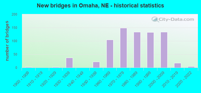
- New bridges - historical statistics
- 21900-1909
- 21920-1929
- 371930-1939
- 221950-1959
- 1051960-1969
- 1491970-1979
- 1341980-1989
- 1321990-1999
- 1342000-2009
- 182010-2019
- 52020-2022
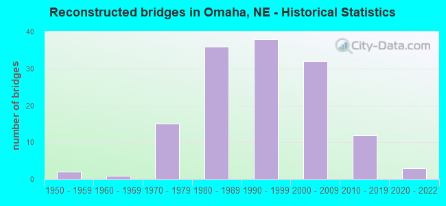
- Reconstructed bridges - Historical Statistics
- 21950-1959
- 11960-1969
- 151970-1979
- 361980-1989
- 381990-1999
- 322000-2009
- 122010-2019
- 32020-2022
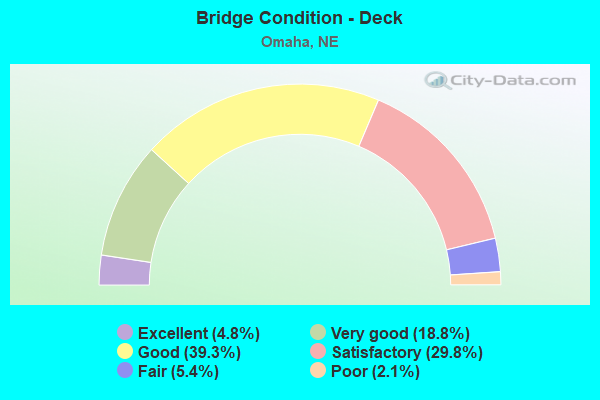
- Bridge Condition - Deck
- 4.8%Excellent
- 18.8%Very good
- 39.3%Good
- 29.8%Satisfactory
- 5.4%Fair
- 2.1%Poor
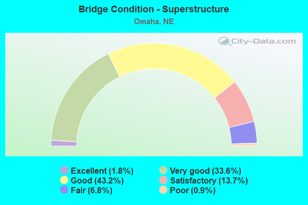
- Bridge Condition - Superstructure
- 1.8%Excellent
- 33.6%Very good
- 43.2%Good
- 13.7%Satisfactory
- 6.8%Fair
- 0.9%Poor
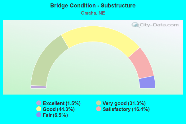
- Bridge Condition - Substructure
- 1.5%Excellent
- 31.3%Very good
- 44.3%Good
- 16.4%Satisfactory
- 6.5%Fair
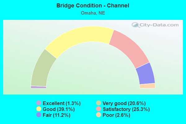
- Bridge Condition - Channel
- 1.3%Excellent
- 20.6%Very good
- 39.1%Good
- 25.3%Satisfactory
- 11.2%Fair
- 2.6%Poor
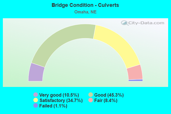
- Bridge Condition - Culverts
- 10.5%Very good
- 45.3%Good
- 34.7%Satisfactory
- 8.4%Fair
- 1.1%Failed
Find on map >> Show street view
Structure Number: S680 00604R, Location: FORT ST INTRCHG (Lat: 41.306700, Lng: -96.070600), Route carried "under" structure: City street 5082, Year Built: 1968, Structure Length: 0. m, Average Daily Traffic: 27,000 (year 2010), Features Intersected: FORT ST/FAU 5082, Facility Carried by Structure: I680
Minimum Vertical Clearance: 4.77m (15.65ft), Kilometerpoint: 16.707, Lanes on structure: 2, Lanes under structure: 2, Material/Design: Concrete continuous, Design/Construction: Slab, Length of Maximum Span: 13.4m (44.0ft)
Find on map >> Show street view
Structure Number: S680 00654, Location: IN OMAHA (Lat: 41.313900, Lng: -96.070300), Route carried "under" structure: Interstate 680, Year Built: 1968, Structure Length: 0. m, Average Daily Traffic: 52,895 (year 2013), Truck Traffic: 4%, Features Intersected: I680, Facility Carried by Structure: MILITARY AVE
Minimum Vertical Clearance: 5.10m (16.73ft), Kilometerpoint: 1.053, Lanes on structure: 4, Lanes under structure: 4, Material/Design: Steel continuous, Design/Construction: Stringer/Multi-beam, Length of Maximum Span: 29.0m (95.1ft)
Find on map >> Show street view
Structure Number: S680 00713, Location: N133/I680 INTRCHG (Lat: 41.322200, Lng: -96.068900), Route carried "under" structure: Interstate 680, Year Built: 1998, Structure Length: 0. m, Average Daily Traffic: 30,865 (year 2013), Truck Traffic: 6%, Features Intersected: I680, Facility Carried by Structure: N133
Minimum Vertical Clearance: 5.15m (16.90ft), Kilometerpoint: 1.147, Lanes on structure: 4, Lanes under structure: 4, Material/Design: Prestressed concrete continuous, Design/Construction: Stringer/Multi-beam, Length of Maximum Span: 31.7m (104.0ft)
Find on map >> Show street view
Structure Number: S680 00761L, Location: IN OMAHA (Lat: 41.327300, Lng: -96.062800), Route carried "under" structure: City street 5021, Year Built: 1971, Structure Length: 0. m, Average Daily Traffic: 15,510 (year 2012), Truck Traffic: 4%, Features Intersected: IRVINGTON RD, Facility Carried by Structure: I680
Minimum Vertical Clearance: 5.10m (16.73ft), Kilometerpoint: 17.257, Lanes on structure: 2, Lanes under structure: 2, Material/Design: Prestressed concrete continuous, Design/Construction: Stringer/Multi-beam, Length of Maximum Span: 16.2m (53.1ft)
Find on map >> Show street view
Structure Number: S680 00761R, Location: IN OMAHA (Lat: 41.327100, Lng: -96.062500), Route carried "under" structure: City street 5021, Year Built: 1971, Structure Length: 0. m, Average Daily Traffic: 15,510 (year 2012), Truck Traffic: 4%, Features Intersected: IRVINGTON RD, Facility Carried by Structure: I680
Minimum Vertical Clearance: 5.23m (17.16ft), Kilometerpoint: 17.254, Lanes on structure: 2, Lanes under structure: 2, Material/Design: Prestressed concrete continuous, Design/Construction: Stringer/Multi-beam, Length of Maximum Span: 16.2m (53.1ft)
Find on map >> Show street view
Structure Number: S680 00836L, Location: IN OMAHA (Lat: 41.333000, Lng: -96.050600), Route carried "under" structure: City street 5125, Year Built: 1971, Structure Length: 0. m, Average Daily Traffic: 1,440 (year 2010), Features Intersected: COLL 39C/KNIGHT CR, Facility Carried by Structure: I680
Minimum Vertical Clearance: 4.67m (15.32ft), Kilometerpoint: 16.101, Lanes on structure: 2, Lanes under structure: 2, Material/Design: Steel continuous, Design/Construction: Stringer/Multi-beam, Length of Maximum Span: 26.5m (86.9ft)
Find on map >> Show street view
Structure Number: S680 00836R, Location: IN OMAHA (Lat: 41.332700, Lng: -96.050500), Route carried "under" structure: City street 5125, Year Built: 1971, Structure Length: 0. m, Average Daily Traffic: 1,440 (year 2010), Features Intersected: COLL 39C/KNIGHT CR, Facility Carried by Structure: I680
Minimum Vertical Clearance: 4.87m (15.98ft), Kilometerpoint: 16.098, Lanes on structure: 2, Lanes under structure: 2, Material/Design: Steel continuous, Design/Construction: Stringer/Multi-beam, Length of Maximum Span: 26.5m (86.9ft)
Find on map >> Show street view
Structure Number: S680 00986, Location: 72ND ST INTRCHG (Lat: 41.341300, Lng: -96.023800), Route carried "under" structure: Interstate 680, Year Built: 1969, Structure Length: 0. m, Average Daily Traffic: 26,010 (year 2013), Truck Traffic: 6%, Features Intersected: I680, Facility Carried by Structure: 72ND ST/FAU 5037
Minimum Vertical Clearance: 5.00m (16.40ft), Kilometerpoint: 1.587, Lanes on structure: 4, Lanes under structure: 4, Material/Design: Steel continuous, Design/Construction: Stringer/Multi-beam, Length of Maximum Span: 29.0m (95.1ft)
Find on map >> Show street view
Structure Number: S680 01092L, Location: 72ND ST INTRCHG 1E (Lat: 41.346300, Lng: -96.004700), Route carried "under" structure: City street 5043, Year Built: 1972, Structure Length: 0. m, Average Daily Traffic: 1,400 (year 2010), Truck Traffic: 4%, Features Intersected: 60TH ST/FAU 5043, Facility Carried by Structure: I680
Minimum Vertical Clearance: 4.67m (15.32ft), Kilometerpoint: 17.843, Lanes on structure: 2, Lanes under structure: 2, Material/Design: Prestressed concrete continuous, Design/Construction: Stringer/Multi-beam, Length of Maximum Span: 16.2m (53.1ft)
Find on map >> Show street view
Structure Number: S680 01092R, Location: 72ND ST INTRCHG 1E (Lat: 41.346000, Lng: -96.004700), Route carried "under" structure: City street 5043, Year Built: 1972, Structure Length: 0. m, Average Daily Traffic: 1,400 (year 2010), Truck Traffic: 4%, Features Intersected: 60TH ST/FAU 5043, Facility Carried by Structure: I680
Minimum Vertical Clearance: 5.35m (17.55ft), Kilometerpoint: 17.840, Lanes on structure: 2, Lanes under structure: 2, Material/Design: Prestressed concrete continuous, Design/Construction: Stringer/Multi-beam, Length of Maximum Span: 16.2m (53.1ft)
Find on map >> Show street view
Structure Number: S680 01150L, Location: US75 INTRCHG 1W (Lat: 41.347000, Lng: -95.993800), Route carried "under" structure: State highway 36, Year Built: 1972, Structure Length: 0. m, Average Daily Traffic: 5,760 (year 2012), Truck Traffic: 10%, Features Intersected: ABND CNWTC/N36, Facility Carried by Structure: I680
Minimum Vertical Clearance: 7.74m (25.39ft), Kilometerpoint: 3.861, Lanes on structure: 4, Lanes under structure: 4, Material/Design: Prestressed concrete continuous, Design/Construction: Stringer/Multi-beam, Length of Maximum Span: 19.8m (65.0ft)
Find on map >> Show street view
Structure Number: S680 01150R, Location: US75 INTRCHG 1W (Lat: 41.346800, Lng: -95.993500), Route carried "under" structure: State highway 36, Year Built: 1972, Structure Length: 0. m, Average Daily Traffic: 5,760 (year 2012), Truck Traffic: 10%, Features Intersected: ABND CNWTC/N36, Facility Carried by Structure: I680
Minimum Vertical Clearance: 7.74m (25.39ft), Kilometerpoint: 3.862, Lanes on structure: 4, Lanes under structure: 4, Material/Design: Prestressed concrete continuous, Design/Construction: Stringer/Multi-beam, Length of Maximum Span: 19.8m (65.0ft)
Find on map >> Show street view
Structure Number: S680 01210L, Location: US75 INTRCHG (Lat: 41.347300, Lng: -95.982100), Route carried "under" structure: US 75, Year Built: 1971, Structure Length: 0. m, Average Daily Traffic: 9,425 (year 2012), Truck Traffic: 6%, Features Intersected: US75, Facility Carried by Structure: I680
Minimum Vertical Clearance: 5.00m (16.40ft), Kilometerpoint: 15.714, Lanes on structure: 4, Lanes under structure: 4, Material/Design: Prestressed concrete continuous, Design/Construction: Stringer/Multi-beam, Length of Maximum Span: 14.3m (46.9ft)
Find on map >> Show street view
Structure Number: S680 01210R, Location: US75 INTRCHG (Lat: 41.347000, Lng: -95.982100), Route carried "under" structure: US 75, Year Built: 1971, Structure Length: 0. m, Average Daily Traffic: 8,450 (year 2012), Truck Traffic: 6%, Features Intersected: US75, Facility Carried by Structure: I680
Minimum Vertical Clearance: 5.99m (19.65ft), Kilometerpoint: 15.710, Lanes on structure: 4, Lanes under structure: 4, Material/Design: Prestressed concrete continuous, Design/Construction: Stringer/Multi-beam, Length of Maximum Span: 14.3m (46.9ft)
Find on map >> Show street view
Structure Number: S680 01305L, Location: 31ST ST INTRCHG (Lat: 41.344700, Lng: -95.964400), Route carried "under" structure: Spur State highway L28H, Year Built: 1973, Structure Length: 0. m, Average Daily Traffic: 14,525 (year 2011), Truck Traffic: 4%, Features Intersected: L28H MORMON BRGE INTRCG, Facility Carried by Structure: I680
Minimum Vertical Clearance: 5.41m (17.75ft), Kilometerpoint: 0.023, Lanes on structure: 4, Lanes under structure: 4, Material/Design: Prestressed concrete continuous, Design/Construction: Stringer/Multi-beam, Length of Maximum Span: 18.3m (60.0ft)
Find on map >> Show street view
Structure Number: S680 01305R, Location: 31ST ST INTRCHG (Lat: 41.344500, Lng: -95.964300), Route carried "under" structure: Spur State highway L28H, Year Built: 1973, Structure Length: 0. m, Average Daily Traffic: 14,525 (year 2011), Truck Traffic: 4%, Features Intersected: L28H MORMON BRGE INTRCG, Facility Carried by Structure: I680
Minimum Vertical Clearance: 4.87m (15.98ft), Kilometerpoint: 0.024, Lanes on structure: 4, Lanes under structure: 4, Material/Design: Prestressed concrete continuous, Design/Construction: Stringer/Multi-beam, Length of Maximum Span: 18.3m (60.0ft)
Find on map >> Show street view
Structure Number: S680 01343L, Location: ECL OMAHA (Lat: 41.346000, Lng: -95.956700), Route carried "under" structure: City street 5103, Year Built: 1973, Structure Length: 0. m, Average Daily Traffic: 1,800 (year 2010), Truck Traffic: 5%, Features Intersected: MISSOURI RIVER, Facility Carried by Structure: I680
Minimum Vertical Clearance: 5.51m (18.08ft), Kilometerpoint: 17.836, Lanes on structure: 2, Lanes under structure: 2, Material/Design: Steel continuous, Design/Construction: Truss - Thru, Length of Maximum Span: 128.0m (419.9ft)
Find on map >> Show street view
Structure Number: S680 01343R, Location: ECL OMAHA (Lat: 41.345800, Lng: -95.956600), Route carried "under" structure: City street 5103, Year Built: 1952, Structure Length: 0. m, Average Daily Traffic: 1,800 (year 2010), Truck Traffic: 5%, Features Intersected: MISSOURI RIVER, Facility Carried by Structure: I680
Minimum Vertical Clearance: 7.62m (25.00ft), Kilometerpoint: 17.835, Lanes on structure: 2, Lanes under structure: 2, Material/Design: Steel continuous, Design/Construction: Truss - Thru, Length of Maximum Span: 128.0m (419.9ft)
Find on map >> Show street view
Structure Number: SL28B00119, Location: IN ELKHORN (Lat: 41.263300, Lng: -96.272700), Route carried "under" structure: State highway L28B, Year Built: 2004, Structure Length: 0. m, Average Daily Traffic: 20,235 (year 2012), Truck Traffic: 7%, Features Intersected: SL28B, Facility Carried by Structure: 228TH ST.
Minimum Vertical Clearance: 5.28m (17.32ft), Kilometerpoint: 0.192, Lanes on structure: 4, Lanes under structure: 4, Material/Design: Prestressed concrete continuous, Design/Construction: Stringer/Multi-beam, Length of Maximum Span: 36.6m (120.1ft)
Find on map >> Show street view
Structure Number: U182500022, Location: 1E WCL OMAHA (Lat: 41.234000, Lng: -96.153400), Route carried "under" structure: City street 38, Year Built: 2010, Structure Length: 0. m, Average Daily Traffic: 21,950 (year 2006), Features Intersected: UPRR 815-676-L, Facility Carried by Structure: UPRR
Minimum Vertical Clearance: 4.97m (16.31ft), Kilometerpoint: 16.129, Lanes on structure: 2, Lanes under structure: 2, Material/Design: Steel continuous, Design/Construction: Stringer/Multi-beam, Length of Maximum Span: 39.6m (129.9ft)
Find on map >> Show street view
Structure Number: U182500145, Location: 139TH & WEST CENTER (Lat: 41.234000, Lng: -96.129600), Route carried "under" structure: City street 38, Year Built: 1977, Structure Length: 0. m, Average Daily Traffic: 37,178 (year 2013), Truck Traffic: 1%, Features Intersected: W CENTER RD, Facility Carried by Structure: PEDESTRAIN OVRPASS
Minimum Vertical Clearance: 5.33m (17.49ft), Kilometerpoint: 16.323, Lanes on structure: 4, Lanes under structure: 4, Material/Design: Steel continuous, Design/Construction: Stringer/Multi-beam, Length of Maximum Span: 26.5m (86.9ft)
Find on map >> Show street view
Structure Number: U182500384, Location: 108TH & WEST CENTER (Lat: 41.234100, Lng: -96.081600), Route carried "under" structure: City street 38, Year Built: 1966, Structure Length: 0. m, Average Daily Traffic: 43,332 (year 2014), Truck Traffic: 5%, Features Intersected: W CENTER RD, Facility Carried by Structure: PEDESTRIAN OVRPASS
Minimum Vertical Clearance: 5.18m (16.99ft), Kilometerpoint: 16.708, Lanes on structure: 4, Lanes under structure: 4, Material/Design: Steel, Design/Construction: Stringer/Multi-beam, Length of Maximum Span: 29.3m (96.1ft)
Find on map >> Show street view
Structure Number: U182500466, Location: 98TH & WEST CENTER (Lat: 41.235000, Lng: -96.065000), Route carried "under" structure: City street 38, Year Built: 1966, Structure Length: 0. m, Average Daily Traffic: 24,176 (year 2012), Truck Traffic: 5%, Features Intersected: W CENTER RD, Facility Carried by Structure: PEDESTRIAN OVRPASS
Minimum Vertical Clearance: 5.71m (18.73ft), Kilometerpoint: 16.840, Lanes on structure: 4, Lanes under structure: 4, Material/Design: Steel, Design/Construction: Stringer/Multi-beam, Length of Maximum Span: 34.1m (111.9ft)
Find on map >> Show street view
Structure Number: U182500573, Location: 86TH & WEST CENTER (Lat: 41.234200, Lng: -96.045500), Route carried "under" structure: City street 38, Year Built: 1975, Structure Length: 0. m, Average Daily Traffic: 32,028 (year 2013), Truck Traffic: 1%, Features Intersected: W CENTER RD, Facility Carried by Structure: PEDESTRAIN OVRPASS
Minimum Vertical Clearance: 5.05m (16.57ft), Kilometerpoint: 17.012, Lanes on structure: 4, Lanes under structure: 4, Material/Design: Steel continuous, Design/Construction: Girder and Floorbeam System, Length of Maximum Span: 28.2m (92.5ft)
Find on map >> Show street view
Structure Number: U182500685, Location: 72ND & WEST CENTER OMAHA (Lat: 41.234500, Lng: -96.023900), Route carried "under" structure: City street 5037, Year Built: 2004, Structure Length: 0. m, Average Daily Traffic: 37,800 (year 2010), Features Intersected: 72ND ST, Facility Carried by Structure: N38/W CENTER RD
Minimum Vertical Clearance: 5.30m (17.39ft), Kilometerpoint: 17.177, Lanes on structure: 4, Lanes under structure: 6, Material/Design: Prestressed concrete continuous, Design/Construction: Stringer/Multi-beam, Length of Maximum Span: 25.3m (83.0ft)
Find on map >> Show street view
Structure Number: U182500898, Location: 48TH & CENTER OMAHA (Lat: 41.241500, Lng: -95.985500), Route carried "under" structure: City street 38, Year Built: 1970, Structure Length: 0. m, Average Daily Traffic: 24,266 (year 2014), Truck Traffic: 1%, Features Intersected: CENTER ST, Facility Carried by Structure: PEDESTRAIN OVRPASS
Minimum Vertical Clearance: 5.14m (16.86ft), Kilometerpoint: 17.535, Lanes on structure: 4, Lanes under structure: 4, Material/Design: Steel continuous, Design/Construction: Box Beam or Girders - Single/Spread, Length of Maximum Span: 24.0m (78.7ft)
Find on map >> Show street view
Structure Number: U18250351, Location: OMAHA 144TH @ US275 (Lat: 41.226000, Lng: -96.138500), Route carried "under" structure: City street 5001, Year Built: 1970, Structure Length: 0. m, Average Daily Traffic: 33,684 (year 2012), Truck Traffic: 5%, Features Intersected: UPRR 815-675-E, Facility Carried by Structure: UPRR
Minimum Vertical Clearance: 5.33m (17.49ft), Kilometerpoint: 16.407, Lanes on structure: 4, Lanes under structure: 4, Material/Design: Steel, Design/Construction: Stringer/Multi-beam, Length of Maximum Span: 262.1m (859.9ft)
Find on map >> Show street view
Structure Number: U182503907, Location: OMAHA 120TH @ PEDERSEN (Lat: 41.221500, Lng: -96.100700), Route carried "under" structure: City street 5009, Year Built: 1993, Structure Length: 0. m, Average Daily Traffic: 25,952 (year 2016), Truck Traffic: 5%, Features Intersected: UPRR 815-673-R, Facility Carried by Structure: UPRR
Minimum Vertical Clearance: 9.93m (32.58ft), Kilometerpoint: 16.270, Lanes on structure: 4, Lanes under structure: 5, Material/Design: Steel, Design/Construction: Stringer/Multi-beam, Length of Maximum Span: 25.9m (85.0ft)
Find on map >> Show street view
Structure Number: U182504505, Location: OMAHA 84TH @ F (Lat: 41.221600, Lng: -96.043000), Route carried "under" structure: City street 5023, Year Built: 1977, Structure Length: 0. m, Average Daily Traffic: 60,402 (year 2015), Truck Traffic: 1%, Features Intersected: UPRR 816-829-R, Facility Carried by Structure: UPRR
Minimum Vertical Clearance: 15.16m (49.74ft), Kilometerpoint: 17.079, Lanes on structure: 6, Lanes under structure: 6, Material/Design: Steel continuous, Design/Construction: Stringer/Multi-beam, Length of Maximum Span: 33.2m (108.9ft)
Find on map >> Show street view
Structure Number: U182504703, Location: 72ND @ WASHINGTON (Lat: 41.199100, Lng: -96.023800), Route carried "under" structure: City street 5037, Year Built: 1989, Structure Length: 0. m, Average Daily Traffic: 33,890 (year 2015), Truck Traffic: 5%, Features Intersected: BNSF RR 073-050-E, Facility Carried by Structure: BNSF RR
Minimum Vertical Clearance: 4.80m (15.75ft), Kilometerpoint: 16.774, Lanes on structure: 4, Lanes under structure: 4, Material/Design: Steel, Design/Construction: Stringer/Multi-beam, Length of Maximum Span: 13.1m (43.0ft)
Find on map >> Show street view
Structure Number: U182504705P, Location: OMAHA 60TH @ V (Lat: 41.198400, Lng: -96.006500), Route carried "under" structure: City street 5043, Year Built: 1904, Structure Length: 0. m, Average Daily Traffic: 5,304 (year 2015), Truck Traffic: 1%, Features Intersected: BNSF RR 073-051-L, Facility Carried by Structure: BNSF RR
Minimum Vertical Clearance: 4.29m (14.07ft), Kilometerpoint: 16.175, Lanes on structure: 2, Lanes under structure: 2, Material/Design: Steel, Design/Construction: Stringer/Multi-beam, Length of Maximum Span: 9.1m (29.9ft)
Find on map >> Show street view
Structure Number: U182504727, Location: OMAHA 72ND @ WESTERN (Lat: 41.270000, Lng: -96.023300), Route carried "under" structure: City street 5037, Year Built: 1975, Structure Length: 0. m, Average Daily Traffic: 40,094 (year 2015), Truck Traffic: 1%, Features Intersected: N 72ND ST, Facility Carried by Structure: PEDESTRIAN OVRPASS
Minimum Vertical Clearance: 5.37m (17.62ft), Kilometerpoint: 17.574, Lanes on structure: 4, Lanes under structure: 4, Material/Design: Steel continuous, Design/Construction: Girder and Floorbeam System, Length of Maximum Span: 29.6m (97.1ft)
Find on map >> Show street view
Structure Number: U182504905, Location: OMAHA 60TH @ DAYTON (Lat: 41.218300, Lng: -96.004600), Route carried "under" structure: City street 5043, Year Built: 1965, Structure Length: 0. m, Average Daily Traffic: 28,570 (year 2014), Truck Traffic: 5%, Features Intersected: ABANDONED UPRR, Facility Carried by Structure: ABANDONED UPRR
Minimum Vertical Clearance: 5.30m (17.39ft), Kilometerpoint: 16.409, Lanes on structure: 4, Lanes under structure: 4, Material/Design: Steel, Design/Construction: Girder and Floorbeam System, Length of Maximum Span: 36.6m (120.1ft)
Find on map >> Show street view
Structure Number: U18250491, Location: OMAHA 60TH @ I80 (Lat: 41.221600, Lng: -96.004500), Route carried "under" structure: City street 5043, Year Built: 1935, Structure Length: 0. m, Average Daily Traffic: 35,450 (year 2014), Truck Traffic: 1%, Features Intersected: UPRR 816-827-C, Facility Carried by Structure: UPRR
Minimum Vertical Clearance: 5.82m (19.09ft), Kilometerpoint: 16.446, Lanes on structure: 4, Lanes under structure: 4, Material/Design: Steel, Design/Construction: Stringer/Multi-beam, Length of Maximum Span: 22.6m (74.1ft)
Find on map >> Show street view
Structure Number: U182505305, Location: OMAHA 36TH @ I (Lat: 41.216600, Lng: -95.966400), Route carried "under" structure: City street 53, Year Built: 1963, Structure Length: 0. m, Average Daily Traffic: 1,636 (year 2014), Truck Traffic: 10%, Features Intersected: BNSF RR, Facility Carried by Structure: BNSF RR
Minimum Vertical Clearance: 4.52m (14.83ft), Kilometerpoint: 0.000, Lanes on structure: 2, Lanes under structure: 2, Material/Design: Steel, Design/Construction: Stringer/Multi-beam, Length of Maximum Span: 11.6m (38.1ft)
Find on map >> Show street view
Structure Number: U18250531, Location: OMAHA 36TH @ H (Lat: 41.216800, Lng: -95.966600), Route carried "under" structure: City street 53, Year Built: 1963, Structure Length: 0. m, Average Daily Traffic: 1,636 (year 2014), Truck Traffic: 10%, Features Intersected: BNSF RR 074-712-F, Facility Carried by Structure: BNSF RR
Minimum Vertical Clearance: 4.72m (15.49ft), Kilometerpoint: 0.000, Lanes on structure: 2, Lanes under structure: 2, Material/Design: Steel, Design/Construction: Stringer/Multi-beam, Length of Maximum Span: 11.6m (38.1ft)
Find on map >> Show street view
Structure Number: U18250553, Location: OMAHA 24TH @ STORZ EXPRWY (Lat: 41.304900, Lng: -95.947100), Route carried "under" structure: City street 5098, Year Built: 1984, Structure Length: 0. m, Average Daily Traffic: 10,800 (year 2010), Features Intersected: STORZ EXPRESSWAY/FAU5098, Facility Carried by Structure: 24TH STREET/FAU 50
Minimum Vertical Clearance: 5.63m (18.47ft), Kilometerpoint: 16.179, Lanes on structure: 4, Lanes under structure: 4, Material/Design: Steel continuous, Design/Construction: Stringer/Multi-beam, Length of Maximum Span: 35.4m (116.1ft)
Find on map >> Show street view
Structure Number: U182521423, Location: FORT ST. @ 99TH ST. (Lat: 41.306600, Lng: -96.066700), Route carried "under" structure: City street 5082, Year Built: 1972, Structure Length: 0. m, Average Daily Traffic: 24,296 (year 2012), Truck Traffic: 1%, Features Intersected: FORT ST, Facility Carried by Structure: PEDESTRIAN OVRPASS
Minimum Vertical Clearance: 4.97m (16.31ft), Kilometerpoint: 16.737, Lanes on structure: 4, Lanes under structure: 4, Material/Design: Concrete, Design/Construction: Tee Beam, Length of Maximum Span: 27.4m (89.9ft)
Find on map >> Show street view
Structure Number: U18252284, Location: OMAHA Q @ 26TH (Lat: 41.205600, Lng: -95.950500), Route carried "under" structure: City street 5143, Year Built: 2020, Structure Length: 0. m, Average Daily Traffic: 5,000 (year 2010), Features Intersected: EBG AVE /UPRR 817-369R, Facility Carried by Structure: Q ST
Minimum Vertical Clearance: 7.31m (23.98ft), Kilometerpoint: 16.248, Lanes on structure: 4, Lanes under structure: 4, Material/Design: Steel, Design/Construction: Girder and Floorbeam System, Length of Maximum Span: 47.2m (154.9ft)
Find on map >> Show street view
Structure Number: U18253184, Location: OMAHA BLONDO @ 69TH (Lat: 41.278300, Lng: -96.018300), Route carried "under" structure: City street 5066, Year Built: 1976, Structure Length: 0. m, Average Daily Traffic: 15,768 (year 2015), Features Intersected: BLONDO ST, Facility Carried by Structure: PEDESTRAIN OVRPASS
Minimum Vertical Clearance: 5.59m (18.34ft), Kilometerpoint: 17.182, Lanes on structure: 2, Lanes under structure: 2, Material/Design: Steel continuous, Design/Construction: Girder and Floorbeam System, Length of Maximum Span: 29.9m (98.1ft)
Find on map >> Show street view
Structure Number: U1825A1005, Location: OMAHA N RIDGE DR @ STATE (Lat: 41.335000, Lng: -95.963300), Route carried "under" structure: City street 5096, Year Built: 1984, Structure Length: 0. m, Average Daily Traffic: 3,490 (year 2009), Truck Traffic: 5%, Features Intersected: STATE STREET, Facility Carried by Structure: NORTH RIDGE DRIVE
Minimum Vertical Clearance: 7.49m (24.57ft), Kilometerpoint: 16.470, Lanes on structure: 2, Lanes under structure: 2, Material/Design: Steel, Design/Construction: Box Beam or Girders - Multiple, Length of Maximum Span: 36.6m (120.1ft)
Find on map >> Show street view
Structure Number: U1825A2205, Location: OMAHA PIERCE @ 5TH (Lat: 41.248300, Lng: -95.921700), Route carried "under" structure: City street A22, Year Built: 1935, Structure Length: 0. m, Average Daily Traffic: 100 (year 2015), Truck Traffic: 10%, Features Intersected: BNSF RR 074-683-X, Facility Carried by Structure: BNSF RR
Minimum Vertical Clearance: 4.24m (13.91ft), Kilometerpoint: 0.000, Lanes on structure: 2, Lanes under structure: 2, Material/Design: Steel, Design/Construction: Stringer/Multi-beam, Length of Maximum Span: 15.8m (51.8ft)
Find on map >> Show street view
Structure Number: U1825A5725, Location: 8TH ST N OF FARNAM ST (Lat: 41.258300, Lng: -95.926700), Route carried "under" structure: City street 5052, Year Built: 1991, Structure Length: 0. m, Average Daily Traffic: 3,200 (year 2006), Features Intersected: ROADWAY, Facility Carried by Structure: PEDESTRIAN OVRPASS
Minimum Vertical Clearance: 5.44m (17.85ft), Kilometerpoint: 16.172, Lanes on structure: 2, Lanes under structure: 3, Material/Design: Steel, Design/Construction: Truss - Thru, Length of Maximum Span: 18.6m (61.0ft)
Find on map >> Show street view
Structure Number: U1825B5702, Location: OMAHA 7TH @ PACIFIC (Lat: 41.249500, Lng: -95.925300), Route carried "under" structure: City street 5048, Year Built: 1935, Structure Length: 0. m, Average Daily Traffic: 1,288 (year 2012), Features Intersected: BNSF RR 074-685-L, Facility Carried by Structure: BNSF RR
Minimum Vertical Clearance: 3.86m (12.66ft), Kilometerpoint: 16.230, Lanes on structure: 2, Lanes under structure: 2, Material/Design: Concrete, Design/Construction: Slab, Length of Maximum Span: 8.2m (26.9ft)
Find on map >> Show street view
Structure Number: U1825B5703, Location: OMAHA 7TH @ MASON (Lat: 41.250200, Lng: -95.925300), Route carried "under" structure: City street 5048, Year Built: 1935, Structure Length: 0. m, Average Daily Traffic: 1,288 (year 2012), Features Intersected: BNSF RR 074-685-L, Facility Carried by Structure: BNSF RR
Minimum Vertical Clearance: 3.86m (12.66ft), Kilometerpoint: 16.224, Lanes on structure: 2, Lanes under structure: 2, Material/Design: Steel, Design/Construction: Stringer/Multi-beam, Length of Maximum Span: 7.9m (25.9ft)
Find on map >> Show street view
Structure Number: U1825B5704, Location: OMAHA 7TH @ MARCY (Lat: 41.250900, Lng: -95.925300), Route carried "under" structure: City street 5048, Year Built: 1935, Structure Length: 0. m, Average Daily Traffic: 1,288 (year 2012), Features Intersected: UPRR, Facility Carried by Structure: UPRR
Minimum Vertical Clearance: 3.86m (12.66ft), Kilometerpoint: 16.215, Lanes on structure: 2, Lanes under structure: 2, Material/Design: Steel, Design/Construction: Stringer/Multi-beam, Length of Maximum Span: 7.9m (25.9ft)
Find on map >> Show street view
Structure Number: U1825C5515, Location: FLRNCE/STORZ EXP INTRCHG (Lat: 41.306700, Lng: -95.943300), Route carried "under" structure: City street 5098, Year Built: 1983, Structure Length: 0. m, Average Daily Traffic: 10,800 (year 2010), Features Intersected: STORZ EXPRESSWAY/FAU5098, Facility Carried by Structure: FLORENCE BLVD
Minimum Vertical Clearance: 5.53m (18.14ft), Kilometerpoint: 16.216, Lanes on structure: 4, Lanes under structure: 4, Material/Design: Steel continuous, Design/Construction: Stringer/Multi-beam, Length of Maximum Span: 33.8m (110.9ft)
Find on map >> Show street view
Structure Number: U1825D2025, Location: DODGE ST @ 83RD ST (Lat: 41.260000, Lng: -96.041700), Route carried "under" structure: City street D20, Year Built: 1991, Structure Length: 0. m, Average Daily Traffic: 8,246 (year 2015), Truck Traffic: 1%, Features Intersected: PEDESTRIAN OVERPASS, Facility Carried by Structure: PEDESTRIAN OVRPASS
Minimum Vertical Clearance: 9.93m (32.58ft), Kilometerpoint: 0.000, Lanes on structure: 4, Lanes under structure: 4, Material/Design: Steel, Design/Construction: Girder and Floorbeam System, Length of Maximum Span: 32.0m (105.0ft)
Find on map >> Show street view
Structure Number: U1825D2203, Location: OMAHA SADDLE CR/WOOLWORTH (Lat: 41.244800, Lng: -95.990600), Route carried "under" structure: City street 5051, Year Built: 1973, Structure Length: 0. m, Average Daily Traffic: 15,282 (year 2015), Truck Traffic: 1%, Features Intersected: S SADDLE CREEK RD, Facility Carried by Structure: PEDESTRIAN OVRPASS
Minimum Vertical Clearance: 5.08m (16.67ft), Kilometerpoint: 16.133, Lanes on structure: 4, Lanes under structure: 6, Material/Design: Steel continuous, Design/Construction: Girder and Floorbeam System, Length of Maximum Span: 27.1m (88.9ft)
Find on map >> Show street view
Structure Number: U1825D5305, Location: OMAHA DAHLMAN @ H (Lat: 41.217600, Lng: -95.961000), Route carried "under" structure: City street 5063, Year Built: 1935, Structure Length: 0. m, Average Daily Traffic: 5,870 (year 2012), Truck Traffic: 1%, Features Intersected: BNSF RR 074-719-D, Facility Carried by Structure: BNSF RR
Minimum Vertical Clearance: 4.37m (14.34ft), Kilometerpoint: 16.272, Lanes on structure: 2, Lanes under structure: 2, Material/Design: Wood or Timber, Design/Construction: Stringer/Multi-beam, Length of Maximum Span: 6.1m (20.0ft)
Find on map >> Show street view
Structure Number: U1825D531, Location: 33RD @ HARNEY ST (Lat: 41.257200, Lng: -95.961400), Route carried "under" structure: City street 5065, Year Built: 1986, Structure Length: 0. m, Average Daily Traffic: 2,402 (year 2010), Truck Traffic: 5%, Features Intersected: ROADWAY, Facility Carried by Structure: PEDESTRIAN OVRPASS
Minimum Vertical Clearance: 5.00m (16.40ft), Kilometerpoint: 16.143, Lanes on structure: 3, Lanes under structure: 3, Material/Design: Steel, Design/Construction: Girder and Floorbeam System, Length of Maximum Span: 21.9m (71.9ft)
Find on map >> Show street view
Structure Number: U1825E5305, Location: OMAHA DAHLMAN @ F (Lat: 41.222900, Lng: -95.959400), Route carried "under" structure: City street 5063, Year Built: 1935, Structure Length: 0. m, Average Daily Traffic: 4,800 (year 2012), Truck Traffic: 10%, Features Intersected: BNSF RR 074-706-C, Facility Carried by Structure: BNSF RR
Minimum Vertical Clearance: 5.30m (17.39ft), Kilometerpoint: 16.335, Lanes on structure: 2, Lanes under structure: 2, Material/Design: Steel, Design/Construction: Stringer/Multi-beam, Length of Maximum Span: 26.2m (86.0ft)
Find on map >> Show street view
Structure Number: U1825F141, Location: OMAHA AMES @ 33RD (Lat: 41.299600, Lng: -95.961500), Route carried "under" structure: City street 5080, Year Built: 1976, Structure Length: 0. m, Average Daily Traffic: 15,578 (year 2011), Truck Traffic: 5%, Features Intersected: ROADWAY, Facility Carried by Structure: PEDESTRIAN OVRPASS
Minimum Vertical Clearance: 4.67m (15.32ft), Kilometerpoint: 16.634, Lanes on structure: 2, Lanes under structure: 2, Material/Design: Steel continuous, Design/Construction: Girder and Floorbeam System, Length of Maximum Span: 21.9m (71.9ft)
Find on map >> Show street view
Structure Number: U1825F2205, Location: OMAHA HICKORY @ 3RD (Lat: 41.243300, Lng: -95.918300), Route carried "under" structure: City street F22, Year Built: 1935, Structure Length: 0. m, Average Daily Traffic: 50 (year 2015), Truck Traffic: 1%, Features Intersected: BNSF RR 074-679-H, Facility Carried by Structure: BNSF RR
Minimum Vertical Clearance: 5.08m (16.67ft), Kilometerpoint: 0.000, Lanes on structure: 2, Lanes under structure: 2, Material/Design: Steel, Design/Construction: Stringer/Multi-beam, Length of Maximum Span: 15.2m (49.9ft)
Find on map >> Show street view
Structure Number: U1825F534, Location: 30TH @ MAPLE ST (Lat: 41.285200, Lng: -95.956500), Route carried "under" structure: City street 5073, Year Built: 1977, Structure Length: 0. m, Average Daily Traffic: 10,508 (year 2012), Truck Traffic: 5%, Features Intersected: ROADWAY, Facility Carried by Structure: PEDESTRAIN OVRPASS
Minimum Vertical Clearance: 4.90m (16.08ft), Kilometerpoint: 16.375, Lanes on structure: 4, Lanes under structure: 4, Material/Design: Steel continuous, Design/Construction: Stringer/Multi-beam, Length of Maximum Span: 23.2m (76.1ft)
Find on map >> Show street view
Structure Number: U1825F5345, Location: 30TH @ SPAULDING ST (Lat: 41.295000, Lng: -95.956700), Route carried "under" structure: City street 5073, Year Built: 1971, Structure Length: 0. m, Average Daily Traffic: 11,138 (year 2009), Truck Traffic: 5%, Features Intersected: ROADWAY, Facility Carried by Structure: PEDESTRAIN OVRPASS
Minimum Vertical Clearance: 4.80m (15.75ft), Kilometerpoint: 16.475, Lanes on structure: 4, Lanes under structure: 4, Material/Design: Steel continuous, Design/Construction: Stringer/Multi-beam, Length of Maximum Span: 24.1m (79.1ft)
Find on map >> Show street view
Structure Number: U1825F551, Location: OMAHA 20TH @ CENTER (Lat: 41.243200, Lng: -95.942200), Route carried "under" structure: City street 5089, Year Built: 1935, Structure Length: 0. m, Average Daily Traffic: 2,520 (year 2012), Truck Traffic: 1%, Features Intersected: BNSF RR 074-695-S, Facility Carried by Structure: BNSF RR
Minimum Vertical Clearance: 4.26m (13.98ft), Kilometerpoint: 17.047, Lanes on structure: 2, Lanes under structure: 4, Material/Design: Steel, Design/Construction: Stringer/Multi-beam, Length of Maximum Span: 18.0m (59.1ft)
Find on map >> Show street view
Structure Number: U1825F5515, Location: OMAHA 20TH @ WOOLWORTH (Lat: 41.244700, Lng: -95.942300), Route carried "under" structure: City street 5089, Year Built: 1900, Structure Length: 0. m, Average Daily Traffic: 1,476 (year 2012), Truck Traffic: 1%, Features Intersected: UPRR 816-817-W, Facility Carried by Structure: UPRR
Minimum Vertical Clearance: 3.82m (12.53ft), Kilometerpoint: 17.030, Lanes on structure: 2, Lanes under structure: 2, Material/Design: Steel, Design/Construction: Stringer/Multi-beam, Length of Maximum Span: 9.8m (32.2ft)
Find on map >> Show street view
Structure Number: U1825G5115, Location: OMAHA 42ND @ VINTON (Lat: 41.226800, Lng: -95.975800), Route carried "under" structure: City street 5057, Year Built: 1961, Structure Length: 0. m, Average Daily Traffic: 35,188 (year 2012), Truck Traffic: 1%, Features Intersected: S 42ND ST, Facility Carried by Structure: PEDESTRIAN OVRPASS
Minimum Vertical Clearance: 4.87m (15.98ft), Kilometerpoint: 16.671, Lanes on structure: 4, Lanes under structure: 4, Material/Design: Steel continuous, Design/Construction: Truss - Thru, Length of Maximum Span: 18.3m (60.0ft)
Find on map >> Show street view
Structure Number: U1825G5118, Location: .3N 42ND & EMILE ST (Lat: 41.254800, Lng: -95.975700), Route carried "under" structure: City street 50570, Year Built: 2006, Structure Length: 0. m, Average Daily Traffic: 14,762 (year 2012), Truck Traffic: 5%, Features Intersected: 42ND STREET, Facility Carried by Structure: PEDESTRIAN OVRPASS
Minimum Vertical Clearance: 5.00m (16.40ft), Kilometerpoint: 17.032, Lanes on structure: 4, Lanes under structure: 4, Material/Design: Steel, Design/Construction: Truss - Thru, Length of Maximum Span: 39.6m (129.9ft)
Find on map >> Show street view
Structure Number: U1825G512, Location: 42ND @ DOUGLAS (Lat: 41.259100, Lng: -95.975800), Route carried "under" structure: City street 5057, Year Built: 1935, Structure Length: 0. m, Average Daily Traffic: 9,448 (year 2015), Truck Traffic: 1%, Features Intersected: S 42ND ST, Facility Carried by Structure: PEDESTRIAN OVRPASS
Minimum Vertical Clearance: 5.18m (16.99ft), Kilometerpoint: 17.030, Lanes on structure: 3, Lanes under structure: 4, Material/Design: Steel continuous, Design/Construction: Girder and Floorbeam System, Length of Maximum Span: 19.2m (63.0ft)
Find on map >> Show street view
Structure Number: U1825H201, Location: FARNAM @ 44TH (Lat: 41.258300, Lng: -95.976700), Route carried "under" structure: City street 5052, Year Built: 1935, Structure Length: 0. m, Average Daily Traffic: 14,658 (year 2015), Truck Traffic: 1%, Features Intersected: FARNAM ST, Facility Carried by Structure: PEDESTRIAN OVRPASS
Minimum Vertical Clearance: 8.07m (26.48ft), Kilometerpoint: 16.611, Lanes on structure: 4, Lanes under structure: 5, Material/Design: Steel, Design/Construction: Segmental Box Girder, Length of Maximum Span: 25.6m (84.0ft)
Find on map >> Show street view
Structure Number: U1825H5515, Location: 18TH ST N. OF FARNAM ST (Lat: 41.258300, Lng: -95.940000), Route carried "under" structure: City street H55, Year Built: 1986, Structure Length: 0. m, Average Daily Traffic: 2,178 (year 2013), Truck Traffic: 1%, Features Intersected: ROADWAY, Facility Carried by Structure: PEDESTRIAN OVRPASS
Minimum Vertical Clearance: 10.97m (35.99ft), Kilometerpoint: 0.000, Lanes on structure: 4, Lanes under structure: 4, Material/Design: Steel, Design/Construction: Girder and Floorbeam System, Length of Maximum Span: 57.9m (190.0ft)
Find on map >> Show street view
Structure Number: U1825I5515, Location: OMAHA 17TH @ FARNAM (Lat: 41.258300, Lng: -95.938300), Route carried "under" structure: City street 5093, Year Built: 1975, Structure Length: 0. m, Average Daily Traffic: 2,820 (year 2011), Truck Traffic: 1%, Features Intersected: PARKING GARAGE, Facility Carried by Structure: PARKING GARAGE
Minimum Vertical Clearance: 6.09m (19.98ft), Kilometerpoint: 16.201, Lanes on structure: 4, Lanes under structure: 6, Material/Design: Concrete, Design/Construction: Stringer/Multi-beam, Length of Maximum Span: 26.2m (86.0ft)
Find on map >> Show street view
Structure Number: U1825J5507, Location: 16TH @ FARNMAN/DOUGLAS (Lat: 41.258300, Lng: -95.936700), Route carried "under" structure: City street J55, Year Built: 1984, Structure Length: 0. m, Average Daily Traffic: 2,655 (year 2013), Truck Traffic: 10%, Features Intersected: ROADWAY, Facility Carried by Structure: PEDESTRIAN OVRPASS
Minimum Vertical Clearance: 5.61m (18.41ft), Kilometerpoint: 0.000, Lanes on structure: 2, Lanes under structure: 2, Material/Design: Concrete, Design/Construction: Stringer/Multi-beam, Length of Maximum Span: 34.1m (111.9ft)
Find on map >> Show street view
Structure Number: U1825K2205, Location: OMAHA MARTHA @ 26TH (Lat: 41.239200, Lng: -95.950500), Route carried "under" structure: City street M53, Year Built: 1990, Structure Length: 0. m, Average Daily Traffic: 150 (year 1997), Truck Traffic: 10%, Features Intersected: UP/BNSF/26TH 816-819-K, Facility Carried by Structure: MARTHA ST/FAU 5038
Minimum Vertical Clearance: 6.62m (21.72ft), Kilometerpoint: 0.000, Lanes on structure: 2, Lanes under structure: 2, Material/Design: Steel continuous, Design/Construction: Stringer/Multi-beam, Length of Maximum Span: 67.1m (220.1ft)
Find on map >> Show street view
Structure Number: U1825M5505, Location: OMAHA 14TH @ MASON (Lat: 41.250000, Lng: -95.935000), Route carried "under" structure: City street M55, Year Built: 1920, Structure Length: 0. m, Average Daily Traffic: 1,094 (year 2011), Truck Traffic: 10%, Features Intersected: BNSF RR 074-688-G, Facility Carried by Structure: BNSF RR
Minimum Vertical Clearance: 5.08m (16.67ft), Kilometerpoint: 0.000, Lanes on structure: 2, Lanes under structure: 2, Material/Design: Steel, Design/Construction: Stringer/Multi-beam, Length of Maximum Span: 13.4m (44.0ft)
Find on map >> Show street view
Structure Number: U1825M551, Location: OMAHA 14TH @ MARCY (Lat: 41.251700, Lng: -95.935000), Route carried "under" structure: City street M55, Year Built: 1935, Structure Length: 0. m, Average Daily Traffic: 1,094 (year 2011), Truck Traffic: 10%, Features Intersected: UPRR 816-815-H, Facility Carried by Structure: UPRR
Minimum Vertical Clearance: 4.37m (14.34ft), Kilometerpoint: 0.000, Lanes on structure: 2, Lanes under structure: 2, Material/Design: Steel, Design/Construction: Stringer/Multi-beam, Length of Maximum Span: 13.7m (44.9ft)
Find on map >> Show street view
Structure Number: U1825M5515, Location: OMAHA 25TH @ JJ PERSHING (Lat: 41.327100, Lng: -95.949600), Route carried "under" structure: City street 5089, Year Built: 1935, Structure Length: 0. m, Average Daily Traffic: 3,300 (year 2006), Features Intersected: UPRR 191-548-A, Facility Carried by Structure: UPRR
Minimum Vertical Clearance: 3.12m (10.24ft), Kilometerpoint: 16.093, Lanes on structure: 2, Lanes under structure: 2, Material/Design: Steel, Design/Construction: Girder and Floorbeam System, Length of Maximum Span: 22.9m (75.1ft)
Find on map >> Show street view
Structure Number: U1825M552, Location: 13TH @ MASON (Lat: 41.250800, Lng: -95.933300), Route carried "under" structure: City street 5121, Year Built: 1935, Structure Length: 0. m, Average Daily Traffic: 13,682 (year 2014), Truck Traffic: 1%, Features Intersected: BNSF RR 074-689-N, Facility Carried by Structure: BNSF RR
Minimum Vertical Clearance: 4.62m (15.16ft), Kilometerpoint: 16.833, Lanes on structure: 4, Lanes under structure: 4, Material/Design: Steel, Design/Construction: Girder and Floorbeam System, Length of Maximum Span: 10.1m (33.1ft)
Find on map >> Show street view
Structure Number: U1825M5525, Location: 13TH @ MARCY (Lat: 41.251100, Lng: -95.933300), Route carried "under" structure: City street 5121, Year Built: 1935, Structure Length: 0. m, Average Daily Traffic: 13,682 (year 2014), Truck Traffic: 1%, Features Intersected: UPRR 816-814-B, Facility Carried by Structure: UPRR
Minimum Vertical Clearance: 4.32m (14.17ft), Kilometerpoint: 16.835, Lanes on structure: 4, Lanes under structure: 4, Material/Design: Steel, Design/Construction: Stringer/Multi-beam, Length of Maximum Span: 10.1m (33.1ft)
Find on map >> Show street view
Structure Number: U1825Q5505, Location: OMAHA 10TH @ LEAVENWORTH (Lat: 41.251700, Lng: -95.928300), Route carried "under" structure: City street 5044, Year Built: 2000, Structure Length: 0. m, Average Daily Traffic: 2,500 (year 2006), Features Intersected: BNSF/UPRR/5044 074-686-T, Facility Carried by Structure: 10TH ST/FAU 5103
Minimum Vertical Clearance: 10.79m (35.40ft), Kilometerpoint: 16.444, Lanes on structure: 4, Lanes under structure: 4, Material/Design: Steel continuous, Design/Construction: Stringer/Multi-beam, Length of Maximum Span: 41.1m (134.8ft)
Find on map >> Show street view
Structure Number: U1825Q5505, Location: OMAHA 10TH @ LEAVENWORTH (Lat: 41.251700, Lng: -95.928300), Route carried "under" structure: City street 5013, Year Built: 2000, Structure Length: 0. m, Average Daily Traffic: 2,500 (year 2006), Features Intersected: BNSF/UPRR/5044 074-686-T, Facility Carried by Structure: 10TH ST/FAU 5103
Minimum Vertical Clearance: 10.79m (35.40ft), Kilometerpoint: 16.444, Lanes on structure: 4, Lanes under structure: 4, Material/Design: Steel continuous, Design/Construction: Stringer/Multi-beam, Length of Maximum Span: 41.1m (134.8ft)