Bridge Statistics for Oxford, Mississippi (MS)
Condition, Traffic, Stress, Structural Evaluation, Project Costs
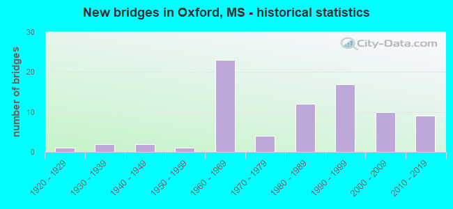
- New bridges - historical statistics
- 11920-1929
- 21930-1939
- 21940-1949
- 11950-1959
- 231960-1969
- 41970-1979
- 121980-1989
- 171990-1999
- 102000-2009
- 92010-2019
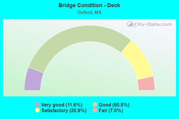
- Bridge Condition - Deck
- 11.6%Very good
- 60.5%Good
- 20.9%Satisfactory
- 7.0%Fair
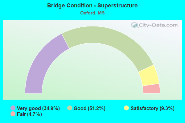
- Bridge Condition - Superstructure
- 34.9%Very good
- 51.2%Good
- 9.3%Satisfactory
- 4.7%Fair
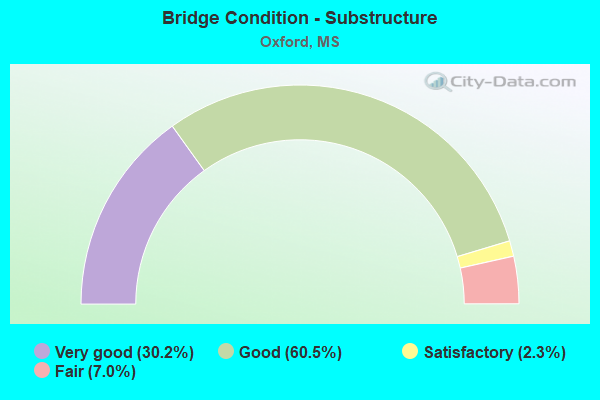
- Bridge Condition - Substructure
- 30.2%Very good
- 60.5%Good
- 2.3%Satisfactory
- 7.0%Fair
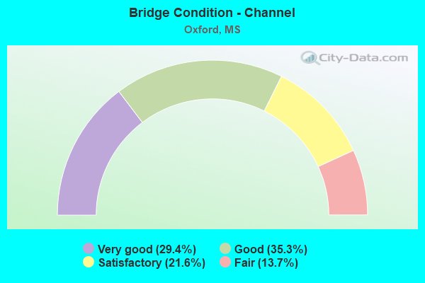
- Bridge Condition - Channel
- 29.4%Very good
- 35.3%Good
- 21.6%Satisfactory
- 13.7%Fair
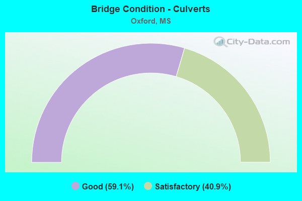
- Bridge Condition - Culverts
- 59.1%Good
- 40.9%Satisfactory
Find on map >> Show street view
Structure Number: 3100006036069, Location: 4.6 MI E PANOLA CL (Lat: 34.356306, Lng: -89.642097), Route carried "on" structure: US 278, Year Built: 1937, Status: Open, Structure Length: 0.73m (2.40ft), Average Daily Traffic: 24,000 (year 2020), Truck Traffic: 8%, Average Future Daily Traffic: 32,000 (year 2040), Design Load: H 15, Features Intersected: STREAM
Minimum Vertical Clearance: 30+ m (98+ ft), Kilometerpoint: 7.422, Lanes on structure: 4, Base Highway Network: Yes (Inventory Route: 27, Subroute: 1), Owner: State Highway Agency, Approaching Roadway Width: 26.8m (87.9ft), Skew: 4 degrees, Material/Design: Concrete, Design/Construction: Culvert, Number Of Spans In Main Unit: 2, Length of Maximum Span: 2.4m (7.9ft)
Condition: Channel: Fair, Culverts: Good, Structural Evaluation: Better than present minimum criteria, Waterway Adequacy: Equal to present minimum criteria, Approach Roadway Alignment: Equal to present desirable criteria, Length Of Structure Improvement: 0.82m (2.69ft), Designated Inspection Frequency: Every 24 months, Inspection Date: May 2021, Bridge Improvement Cost: $45,000,000, Roadway Improvement Cost: $200,000,000, Total Project Cost: $275,000,000
Find on map >> Show street view
Structure Number: 31000060360716, Location: 7.2 MI E PANOLA CL (Lat: 34.359506, Lng: -89.598617), Route carried "on" structure: US 278, Year Built: 1981, Status: Open, Structure Length: 1.49m (4.89ft), Average Daily Traffic: 24,000 (year 2020), Truck Traffic: 8%, Average Future Daily Traffic: 32,000 (year 2040), Design Load: HS 20, Features Intersected: GOOSE CREEK
Minimum Vertical Clearance: 30+ m (98+ ft), Kilometerpoint: 11.439, Lanes on structure: 4, Base Highway Network: Yes (Inventory Route: 27, Subroute: 1), Owner: State Highway Agency, Approaching Roadway Width: 26.8m (87.9ft), Material/Design: Concrete, Design/Construction: Culvert, Number Of Spans In Main Unit: 3, Length of Maximum Span: 4.6m (15.1ft)
Condition: Channel: Satisfactory, Culverts: Good, Operating Rating: 95.4 metric tons, Method Used To Determine Operating Rating: Load Factor (LF), Inventory Rating: 57.0 metric tons, Method Used To Determine Inventory Rating: Load Factor (LF), Structural Evaluation: Better than present minimum criteria, Waterway Adequacy: Equal to present minimum criteria, Approach Roadway Alignment: Equal to present desirable criteria, Length Of Structure Improvement: 1.49m (4.89ft), Designated Inspection Frequency: Every 24 months, Inspection Date: May 2021, Bridge Improvement Cost: $187,000,000, Roadway Improvement Cost: $200,000,000, Total Project Cost: $449,000,000
Find on map >> Show street view
Structure Number: 31000060360767A, Location: 0.2 MI W SR 7 (Lat: 34.354231, Lng: -89.512339), Route carried "on" structure: US 278, Year Built: 1964, Status: Open, Structure Length: 4.72m (15.49ft), Average Daily Traffic: 13,500 (year 2020), Truck Traffic: 5%, Average Future Daily Traffic: 14,000 (year 2040), Design Load: HS 20, Features Intersected: S.18TH ST EXTENDED
Minimum Vertical Clearance: 30+ m (98+ ft), Kilometerpoint: 25.645, Lanes on structure: 2, Lanes under structure: 2, Base Highway Network: Yes (Inventory Route: 27, Subroute: 1), Owner: State Highway Agency, Approaching Roadway Width: 12.2m (40.0ft), Skew: 1 degrees, Material/Design: Prestressed concrete, Design/Construction: Stringer/Multi-beam, Number Of Spans In Main Unit: 3, Length of Maximum Span: 15.5m (50.9ft), Curb or Sidewalk Widths: Left: 0.5m (1.6ft), Right: 0.5m (1.6ft), Curb-To-Curb Width: 12.2m (40.0ft), Out-to-Out Width: 12.7m (41.7ft)
Condition: Deck: Good, Superstructure: Very good, Substructure: Very good, Operating Rating: 60.7 metric tons, Method Used To Determine Operating Rating: Load Factor (LF), Inventory Rating: 36.4 metric tons, Method Used To Determine Inventory Rating: Load Factor (LF), Structural Evaluation: Equal to present desirable criteria, Deck Geometry: Better than present minimum criteria, Underclear: Meets minimum limits, Approach Roadway Alignment: Equal to present desirable criteria, Designated Inspection Frequency: Every 24 months, Inspection Date: May 2021, Deck Structure Type: Concrete Cast-file-Place
Find on map >> Show street view
Structure Number: 31000060360767B, Location: 0.2 MI W SR 7 (Lat: 34.354058, Lng: -89.512931), Route carried "on" structure: US 278, Year Built: 1964, Status: Open, Structure Length: 4.72m (15.49ft), Average Daily Traffic: 13,500 (year 2020), Truck Traffic: 5%, Average Future Daily Traffic: 14,000 (year 2040), Design Load: HS 20, Features Intersected: S 18TH ST EXTENDED
Minimum Vertical Clearance: 30+ m (98+ ft), Kilometerpoint: 19.438, Lanes on structure: 3, Lanes under structure: 2, Base Highway Network: Yes (Inventory Route: 27, Subroute: 1), Owner: State Highway Agency, Approaching Roadway Width: 12.2m (40.0ft), Skew: 1 degrees, Material/Design: Prestressed concrete, Design/Construction: Stringer/Multi-beam, Number Of Spans In Main Unit: 3, Length of Maximum Span: 15.5m (50.9ft), Curb or Sidewalk Widths: Left: 0.5m (1.6ft), Right: 0.5m (1.6ft), Curb-To-Curb Width: 12.2m (40.0ft), Out-to-Out Width: 12.7m (41.7ft)
Condition: Deck: Satisfactory, Superstructure: Very good, Substructure: Very good, Operating Rating: 60.7 metric tons, Method Used To Determine Operating Rating: Load Factor (LF), Inventory Rating: 36.4 metric tons, Method Used To Determine Inventory Rating: Load Factor (LF), Structural Evaluation: Equal to present desirable criteria, Deck Geometry: High priority of replacement, Underclear: Meets minimum limits, Approach Roadway Alignment: Equal to present desirable criteria, Length Of Structure Improvement: 6.10m (20.01ft), Designated Inspection Frequency: Every 24 months, Inspection Date: May 2021, Bridge Improvement Cost: $558,000,000, Roadway Improvement Cost: $56,000,000, Total Project Cost: $999,999,000, Deck Structure Type: Concrete Cast-file-Place
Find on map >> Show street view
Structure Number: 31000060360768, Location: 0.1 MI W SR 7 (Lat: 34.354058, Lng: -89.512000), Route carried "on" structure: US 278, Year Built: 1964, Status: Open, Structure Length: 0.85m (2.79ft), Average Daily Traffic: 27,000 (year 2020), Truck Traffic: 5%, Average Future Daily Traffic: 28,000 (year 2040), Design Load: HS 20, Features Intersected: BURNEY BRANCH
Minimum Vertical Clearance: 30+ m (98+ ft), Kilometerpoint: 19.523, Lanes on structure: 6, Base Highway Network: Yes (Inventory Route: 27, Subroute: 1), Owner: State Highway Agency, Approaching Roadway Width: 23.2m (76.1ft), Skew: 1 degrees, Material/Design: Concrete, Design/Construction: Culvert, Number Of Spans In Main Unit: 1, Length of Maximum Span: 7.3m (24.0ft)
Condition: Channel: Good, Culverts: Good, Structural Evaluation: Better than present minimum criteria, Waterway Adequacy: Equal to present minimum criteria, Approach Roadway Alignment: Equal to present desirable criteria, Length Of Structure Improvement: 0.85m (2.79ft), Designated Inspection Frequency: Every 24 months, Inspection Date: May 2021, Bridge Improvement Cost: $63,000,000, Roadway Improvement Cost: $200,000,000, Total Project Cost: $306,000,000
Find on map >> Show street view
Structure Number: 31000060360789A, Location: 1.8 MI E SR 7 (Lat: 34.357236, Lng: -89.479650), Route carried "on" structure: US 278, Year Built: 1993, Status: Open, Structure Length: 6.16m (20.21ft), Average Daily Traffic: 7,000 (year 2020), Truck Traffic: 10%, Average Future Daily Traffic: 9,500 (year 2040), Design Load: HS 20, Features Intersected: FOURMILE CREEK
Minimum Vertical Clearance: 30+ m (98+ ft), Kilometerpoint: 22.518, Lanes on structure: 2, Base Highway Network: Yes (Inventory Route: 27, Subroute: 1), Owner: State Highway Agency, Approaching Roadway Width: 12.2m (40.0ft), Material/Design: Prestressed concrete continuous, Design/Construction: Stringer/Multi-beam, Number Of Spans In Main Unit: 5, Length of Maximum Span: 12.2m (40.0ft), Curb-To-Curb Width: 12.2m (40.0ft), Out-to-Out Width: 13.0m (42.7ft)
Condition: Deck: Very good, Superstructure: Very good, Substructure: Very good, Channel: Very good, Operating Rating: 57.5 metric tons, Method Used To Determine Operating Rating: Load Factor (LF), Inventory Rating: 34.5 metric tons, Method Used To Determine Inventory Rating: Load Factor (LF), Structural Evaluation: Equal to present desirable criteria, Deck Geometry: Better than present minimum criteria, Waterway Adequacy: Equal to present desirable criteria, Approach Roadway Alignment: Equal to present desirable criteria, Designated Inspection Frequency: Every 24 months, Inspection Date: May 2021, Deck Structure Type: Concrete Cast-file-Place
Find on map >> Show street view
Structure Number: 31000060360789B, Location: 1.8 MI E SR 7 (Lat: 34.357094, Lng: -89.480419), Route carried "on" structure: US 278, Year Built: 1992, Status: Open, Structure Length: 6.13m (20.11ft), Average Daily Traffic: 7,000 (year 2020), Truck Traffic: 10%, Average Future Daily Traffic: 7,000 (year 2040), Design Load: HS 20, Features Intersected: FOURMILE CREEK
Minimum Vertical Clearance: 30+ m (98+ ft), Kilometerpoint: 22.542, Lanes on structure: 2, Base Highway Network: Yes (Inventory Route: 27, Subroute: 1), Owner: State Highway Agency, Approaching Roadway Width: 12.2m (40.0ft), Material/Design: Prestressed concrete continuous, Design/Construction: Stringer/Multi-beam, Number Of Spans In Main Unit: 5, Length of Maximum Span: 12.2m (40.0ft), Curb-To-Curb Width: 12.2m (40.0ft), Out-to-Out Width: 13.0m (42.7ft)
Condition: Deck: Good, Superstructure: Very good, Substructure: Very good, Channel: Very good, Operating Rating: 57.5 metric tons, Method Used To Determine Operating Rating: Load Factor (LF), Inventory Rating: 34.5 metric tons, Method Used To Determine Inventory Rating: Load Factor (LF), Structural Evaluation: Equal to present desirable criteria, Deck Geometry: Better than present minimum criteria, Waterway Adequacy: Equal to present desirable criteria, Approach Roadway Alignment: Equal to present desirable criteria, Designated Inspection Frequency: Every 24 months, Inspection Date: May 2021, Deck Structure Type: Concrete Cast-file-Place
Find on map >> Show street view
Structure Number: 31000060360805A, Location: 3.5 MI E SR 7 (Lat: 34.348075, Lng: -89.454369), Route carried "on" structure: US 278, Year Built: 1993, Status: Open, Structure Length: 5.09m (16.70ft), Average Daily Traffic: 7,000 (year 2020), Truck Traffic: 10%, Average Future Daily Traffic: 9,500 (year 2040), Design Load: HS 20, Features Intersected: YELLOW LEAF CREEK
Minimum Vertical Clearance: 30+ m (98+ ft), Kilometerpoint: 19.980, Lanes on structure: 2, Base Highway Network: Yes (Inventory Route: 27, Subroute: 1), Owner: State Highway Agency, Approaching Roadway Width: 12.2m (40.0ft), Material/Design: Prestressed concrete continuous, Design/Construction: Stringer/Multi-beam, Number Of Spans In Main Unit: 3, Length of Maximum Span: 16.8m (55.1ft), Curb-To-Curb Width: 12.2m (40.0ft), Out-to-Out Width: 13.0m (42.7ft)
Condition: Deck: Very good, Superstructure: Good, Substructure: Good, Channel: Satisfactory, Operating Rating: 58.4 metric tons, Method Used To Determine Operating Rating: Load Factor (LF), Inventory Rating: 31.3 metric tons, Method Used To Determine Inventory Rating: Load Factor (LF), Structural Evaluation: Better than present minimum criteria, Deck Geometry: Better than present minimum criteria, Waterway Adequacy: Equal to present desirable criteria, Approach Roadway Alignment: Equal to present desirable criteria, Designated Inspection Frequency: Every 24 months, Inspection Date: May 2021, Deck Structure Type: Concrete Cast-file-Place
Find on map >> Show street view
Structure Number: 31000060360805B, Location: 3.5 MI E SR 7 (Lat: 34.347950, Lng: -89.455039), Route carried "on" structure: US 278, Year Built: 1992, Status: Open, Structure Length: 5.06m (16.60ft), Average Daily Traffic: 7,000 (year 2020), Truck Traffic: 10%, Average Future Daily Traffic: 9,500 (year 2040), Design Load: HS 20, Features Intersected: YELLOW LEAF CREEK
Minimum Vertical Clearance: 30+ m (98+ ft), Kilometerpoint: 25.088, Lanes on structure: 2, Base Highway Network: Yes (Inventory Route: 27, Subroute: 1), Owner: State Highway Agency, Approaching Roadway Width: 12.2m (40.0ft), Material/Design: Prestressed concrete continuous, Design/Construction: Stringer/Multi-beam, Number Of Spans In Main Unit: 3, Length of Maximum Span: 16.8m (55.1ft), Curb-To-Curb Width: 12.2m (40.0ft), Out-to-Out Width: 13.0m (42.7ft)
Condition: Deck: Good, Superstructure: Very good, Substructure: Very good, Channel: Good, Operating Rating: 58.4 metric tons, Method Used To Determine Operating Rating: Load Factor (LF), Inventory Rating: 31.3 metric tons, Method Used To Determine Inventory Rating: Load Factor (LF), Structural Evaluation: Better than present minimum criteria, Deck Geometry: Better than present minimum criteria, Waterway Adequacy: Equal to present desirable criteria, Approach Roadway Alignment: Equal to present desirable criteria, Designated Inspection Frequency: Every 24 months, Inspection Date: May 2021, Deck Structure Type: Concrete Cast-file-Place
Find on map >> Show street view
Structure Number: 31000070361172, Location: 13.4 MI N YALOBUSHA CL (Lat: 34.336736, Lng: -89.514328), Route carried "on" structure: State highway 7, Year Built: 1971, Status: Open, Structure Length: 1.43m (4.69ft), Average Daily Traffic: 16,000 (year 2020), Truck Traffic: 6%, Average Future Daily Traffic: 23,000 (year 2040), Design Load: HS 20, Features Intersected: BURNEY BRANCH
Minimum Vertical Clearance: 30+ m (98+ ft), Kilometerpoint: 21.261, Lanes on structure: 2, Base Highway Network: Yes (, Subroute: 1), Owner: State Highway Agency, Approaching Roadway Width: 12.2m (40.0ft), Skew: 4 degrees, Material/Design: Concrete, Design/Construction: Culvert, Number Of Spans In Main Unit: 2, Length of Maximum Span: 4.9m (16.1ft)
Condition: Channel: Satisfactory, Culverts: Satisfactory, Operating Rating: 99.8 metric tons, Method Used To Determine Operating Rating: Load Factor (LF), Inventory Rating: 72.6 metric tons, Method Used To Determine Inventory Rating: Load Factor (LF), Structural Evaluation: Equal to present minimum criteria, Waterway Adequacy: Equal to present minimum criteria, Approach Roadway Alignment: Equal to present desirable criteria, Designated Inspection Frequency: Every 24 months, Inspection Date: August 2020
Find on map >> Show street view
Structure Number: 31000070361181A, Location: SR 7 OVER US 278 (Lat: 34.354450, Lng: -89.508556), Route carried "on" structure: State highway 7, Year Built: 1967, Status: Open, Structure Length: 7.38m (24.21ft), Average Daily Traffic: 8,000 (year 2020), Truck Traffic: 6%, Average Future Daily Traffic: 11,500 (year 2040), Design Load: HS 20, Features Intersected: US 278
Minimum Vertical Clearance: 30+ m (98+ ft), Kilometerpoint: 4.458, Lanes on structure: 2, Lanes under structure: 4, Base Highway Network: Yes (, Subroute: 1), Owner: State Highway Agency, Approaching Roadway Width: 8.5m (27.9ft), Skew: 1 degrees, Material/Design: Prestressed concrete, Design/Construction: Stringer/Multi-beam, Number Of Spans In Main Unit: 4, Length of Maximum Span: 18.3m (60.0ft), Curb or Sidewalk Widths: Left: 0.5m (1.6ft), Right: 0.5m (1.6ft), Curb-To-Curb Width: 8.5m (27.9ft), Out-to-Out Width: 9.1m (29.9ft)
Condition: Deck: Good, Superstructure: Very good, Substructure: Good, Operating Rating: 67.6 metric tons, Method Used To Determine Operating Rating: Load Factor (LF), Inventory Rating: 40.5 metric tons, Method Used To Determine Inventory Rating: Load Factor (LF), Structural Evaluation: Better than present minimum criteria, Deck Geometry: High priority of corrective action, Underclear: Equal to present minimum criteria, Approach Roadway Alignment: Equal to present desirable criteria, Length Of Structure Improvement: 7.38m (24.21ft), Designated Inspection Frequency: Every 24 months, Inspection Date: August 2020, Bridge Improvement Cost: $210,000,000, Roadway Improvement Cost: $26,000,000, Total Project Cost: $286,000,000, Deck Structure Type: Concrete Cast-file-Place
Find on map >> Show street view
Structure Number: 31000070361181B, Location: SR 7 OVER US 278 (Lat: 34.353806, Lng: -89.508536), Route carried "on" structure: State highway 7, Year Built: 1967, Status: Open, Structure Length: 7.38m (24.21ft), Average Daily Traffic: 8,000 (year 2020), Truck Traffic: 6%, Average Future Daily Traffic: 8,000 (year 2040), Design Load: HS 20, Features Intersected: US 278
Minimum Vertical Clearance: 30+ m (98+ ft), Kilometerpoint: 23.229, Lanes on structure: 2, Lanes under structure: 4, Base Highway Network: Yes (, Subroute: 1), Owner: State Highway Agency, Approaching Roadway Width: 8.5m (27.9ft), Skew: 1 degrees, Material/Design: Prestressed concrete, Design/Construction: Stringer/Multi-beam, Number Of Spans In Main Unit: 4, Length of Maximum Span: 18.3m (60.0ft), Curb or Sidewalk Widths: Left: 0.5m (1.6ft), Right: 0.5m (1.6ft), Curb-To-Curb Width: 8.5m (27.9ft), Out-to-Out Width: 9.1m (29.9ft)
Condition: Deck: Good, Superstructure: Good, Substructure: Good, Operating Rating: 67.6 metric tons, Method Used To Determine Operating Rating: Load Factor (LF), Inventory Rating: 40.5 metric tons, Method Used To Determine Inventory Rating: Load Factor (LF), Structural Evaluation: Better than present minimum criteria, Deck Geometry: High priority of corrective action, Underclear: Somewhat better than minimum adequacy, Approach Roadway Alignment: Equal to present desirable criteria, Length Of Structure Improvement: 7.38m (24.21ft), Designated Inspection Frequency: Every 24 months, Inspection Date: July 2020, Bridge Improvement Cost: $110,000,000, Roadway Improvement Cost: $26,000,000, Total Project Cost: $360,000,000, Deck Structure Type: Concrete Cast-file-Place
Find on map >> Show street view
Structure Number: 31000070361187A, Location: 0.6 MI N SR 6 (Lat: 34.362342, Lng: -89.505925), Route carried "on" structure: State highway 7, Year Built: 1967, Status: Open, Structure Length: 6.16m (20.21ft), Average Daily Traffic: 12,000 (year 2020), Truck Traffic: 7%, Average Future Daily Traffic: 12,000 (year 2040), Design Load: HS 20, Features Intersected: UNIVERSITY AVENUE
Minimum Vertical Clearance: 30+ m (98+ ft), Kilometerpoint: 3.550, Lanes on structure: 2, Lanes under structure: 2, Base Highway Network: Yes (, Subroute: 1), Owner: State Highway Agency, Approaching Roadway Width: 8.5m (27.9ft), Material/Design: Prestressed concrete, Design/Construction: Stringer/Multi-beam, Number Of Spans In Main Unit: 4, Length of Maximum Span: 15.2m (49.9ft), Curb or Sidewalk Widths: Left: 0.5m (1.6ft), Right: 0.5m (1.6ft), Curb-To-Curb Width: 8.5m (27.9ft), Out-to-Out Width: 9.1m (29.9ft)
Condition: Deck: Satisfactory, Superstructure: Very good, Substructure: Good, Operating Rating: 56.1 metric tons, Method Used To Determine Operating Rating: Load Factor (LF), Inventory Rating: 33.6 metric tons, Method Used To Determine Inventory Rating: Load Factor (LF), Structural Evaluation: Better than present minimum criteria, Deck Geometry: High priority of corrective action, Underclear: Better than present minimum criteria, Approach Roadway Alignment: Equal to present desirable criteria, Length Of Structure Improvement: 7.93m (26.02ft), Designated Inspection Frequency: Every 24 months, Inspection Date: August 2020, Bridge Improvement Cost: $729,000,000, Roadway Improvement Cost: $73,000,000, Total Project Cost: $999,999,000, Deck Structure Type: Concrete Cast-file-Place
Find on map >> Show street view
Structure Number: 31000070361187B, Location: 0.6 MI N SR 6 (Lat: 34.361786, Lng: -89.505886), Route carried "on" structure: State highway 7, Year Built: 1967, Status: Open, Structure Length: 6.16m (20.21ft), Average Daily Traffic: 12,000 (year 2020), Truck Traffic: 7%, Average Future Daily Traffic: 12,000 (year 2040), Design Load: HS 20, Features Intersected: UNIVERSITY AVENUE
Minimum Vertical Clearance: 30+ m (98+ ft), Kilometerpoint: 24.147, Lanes on structure: 2, Lanes under structure: 2, Base Highway Network: Yes (, Subroute: 1), Owner: State Highway Agency, Approaching Roadway Width: 8.5m (27.9ft), Material/Design: Prestressed concrete, Design/Construction: Stringer/Multi-beam, Number Of Spans In Main Unit: 4, Length of Maximum Span: 15.2m (49.9ft), Curb or Sidewalk Widths: Left: 0.5m (1.6ft), Right: 0.5m (1.6ft), Curb-To-Curb Width: 8.5m (27.9ft), Out-to-Out Width: 9.1m (29.9ft)
Condition: Deck: Good, Superstructure: Good, Substructure: Good, Operating Rating: 56.1 metric tons, Method Used To Determine Operating Rating: Load Factor (LF), Inventory Rating: 33.6 metric tons, Method Used To Determine Inventory Rating: Load Factor (LF), Structural Evaluation: Better than present minimum criteria, Deck Geometry: High priority of corrective action, Underclear: Better than present minimum criteria, Approach Roadway Alignment: Equal to present desirable criteria, Length Of Structure Improvement: 6.16m (20.21ft), Designated Inspection Frequency: Every 24 months, Inspection Date: July 2020, Bridge Improvement Cost: $184,000,000, Roadway Improvement Cost: $26,000,000, Total Project Cost: $252,000,000, Deck Structure Type: Concrete Cast-file-Place
Find on map >> Show street view
Structure Number: 31000070361201A, Location: 2.0 MI N SR 6 (Lat: 34.373339, Lng: -89.500903), Route carried "on" structure: State highway 7, Year Built: 1967, Status: Open, Structure Length: 4.72m (15.49ft), Average Daily Traffic: 11,500 (year 2020), Truck Traffic: 7%, Average Future Daily Traffic: 12,000 (year 2040), Design Load: HS 20, Features Intersected: SISK AVENUE
Minimum Vertical Clearance: 30+ m (98+ ft), Kilometerpoint: 2.243, Lanes on structure: 2, Lanes under structure: 2, Base Highway Network: Yes (, Subroute: 1), Owner: State Highway Agency, Approaching Roadway Width: 8.5m (27.9ft), Skew: 2 degrees, Material/Design: Prestressed concrete, Design/Construction: Stringer/Multi-beam, Number Of Spans In Main Unit: 1, Number Of Approach Spans: 2, Length of Maximum Span: 19.2m (63.0ft), Curb or Sidewalk Widths: Left: 0.5m (1.6ft), Right: 0.5m (1.6ft), Curb-To-Curb Width: 8.5m (27.9ft), Out-to-Out Width: 9.1m (29.9ft)
Condition: Deck: Satisfactory, Superstructure: Good, Substructure: Good, Operating Rating: 50.9 metric tons, Method Used To Determine Operating Rating: Load Factor (LF), Inventory Rating: 30.5 metric tons, Method Used To Determine Inventory Rating: Load Factor (LF), Structural Evaluation: Better than present minimum criteria, Deck Geometry: High priority of replacement, Underclear: Meets minimum limits, Approach Roadway Alignment: Equal to present desirable criteria, Length Of Structure Improvement: 4.72m (15.49ft), Designated Inspection Frequency: Every 24 months, Inspection Date: August 2020, Bridge Improvement Cost: $147,000,000, Roadway Improvement Cost: $26,000,000, Total Project Cost: $208,000,000, Deck Structure Type: Concrete Cast-file-Place
Find on map >> Show street view
Structure Number: 31000070361201B, Location: 2.0 MI N SR 6 (Lat: 34.372942, Lng: -89.500878), Route carried "on" structure: State highway 7, Year Built: 1967, Status: Open, Structure Length: 4.72m (15.49ft), Average Daily Traffic: 11,500 (year 2020), Truck Traffic: 7%, Average Future Daily Traffic: 12,000 (year 2040), Design Load: HS 20, Features Intersected: SISK AVENUE
Minimum Vertical Clearance: 30+ m (98+ ft), Kilometerpoint: 25.471, Lanes on structure: 2, Lanes under structure: 3, Base Highway Network: Yes (, Subroute: 1), Owner: State Highway Agency, Approaching Roadway Width: 8.5m (27.9ft), Skew: 2 degrees, Material/Design: Prestressed concrete, Design/Construction: Stringer/Multi-beam, Number Of Spans In Main Unit: 1, Number Of Approach Spans: 2, Length of Maximum Span: 19.2m (63.0ft), Curb or Sidewalk Widths: Left: 0.5m (1.6ft), Right: 0.5m (1.6ft), Curb-To-Curb Width: 8.5m (27.9ft), Out-to-Out Width: 9.1m (29.9ft)
Condition: Deck: Good, Superstructure: Good, Substructure: Good, Operating Rating: 50.9 metric tons, Method Used To Determine Operating Rating: Load Factor (LF), Inventory Rating: 30.5 metric tons, Method Used To Determine Inventory Rating: Load Factor (LF), Structural Evaluation: Better than present minimum criteria, Deck Geometry: High priority of replacement, Underclear: Meets minimum limits, Approach Roadway Alignment: Equal to present desirable criteria, Length Of Structure Improvement: 4.72m (15.49ft), Designated Inspection Frequency: Every 24 months, Inspection Date: July 2020, Bridge Improvement Cost: $147,000,000, Roadway Improvement Cost: $26,000,000, Total Project Cost: $208,000,000, Deck Structure Type: Concrete Cast-file-Place
Find on map >> Show street view
Structure Number: 31000070361228, Location: 1.9 MI N SR 30 (Lat: 34.411050, Lng: -89.495264), Route carried "on" structure: State highway 7, Year Built: 1981, Status: Open, Structure Length: 0.82m (2.69ft), Average Daily Traffic: 6,300 (year 2020), Truck Traffic: 8%, Average Future Daily Traffic: 8,500 (year 2040), Design Load: HS 20, Features Intersected: DITCH AG UNDERPASS
Minimum Vertical Clearance: 30+ m (98+ ft), Kilometerpoint: 29.776, Lanes on structure: 3, Base Highway Network: Yes (, Subroute: 1), Owner: State Highway Agency, Approaching Roadway Width: 13.4m (44.0ft), Skew: 1 degrees, Material/Design: Concrete, Design/Construction: Culvert, Number Of Spans In Main Unit: 2, Length of Maximum Span: 3.7m (12.1ft)
Condition: Channel: Very good, Culverts: Good, Structural Evaluation: Better than present minimum criteria, Waterway Adequacy: Equal to present desirable criteria, Approach Roadway Alignment: Equal to present desirable criteria, Designated Inspection Frequency: Every 24 months, Inspection Date: July 2020
Find on map >> Show street view
Structure Number: 31000070361238, Location: 2.9 MI N SR 30 (Lat: 34.424203, Lng: -89.495950), Route carried "on" structure: State highway 7, Year Built: 1982, Status: Open, Structure Length: 6.16m (20.21ft), Average Daily Traffic: 6,300 (year 2020), Truck Traffic: 8%, Average Future Daily Traffic: 8,500 (year 2040), Design Load: HS 20, Features Intersected: HURRICANE CREEK
Minimum Vertical Clearance: 30+ m (98+ ft), Kilometerpoint: 31.236, Lanes on structure: 2, Base Highway Network: Yes (, Subroute: 1), Owner: State Highway Agency, Approaching Roadway Width: 11.7m (38.4ft), Material/Design: Prestressed concrete continuous, Design/Construction: Stringer/Multi-beam, Number Of Spans In Main Unit: 5, Length of Maximum Span: 12.2m (40.0ft), Curb-To-Curb Width: 11.7m (38.4ft), Out-to-Out Width: 12.6m (41.3ft)
Condition: Deck: Good, Superstructure: Good, Substructure: Good, Channel: Good, Operating Rating: 58.0 metric tons, Method Used To Determine Operating Rating: Load Factor (LF), Inventory Rating: 34.7 metric tons, Method Used To Determine Inventory Rating: Load Factor (LF), Structural Evaluation: Better than present minimum criteria, Deck Geometry: Somewhat better than minimum adequacy, Waterway Adequacy: Equal to present desirable criteria, Approach Roadway Alignment: Equal to present desirable criteria, Length Of Structure Improvement: 6.16m (20.21ft), Designated Inspection Frequency: Every 24 months, Inspection Date: July 2020, Bridge Improvement Cost: $115,000,000, Roadway Improvement Cost: $200,000,000, Total Project Cost: $365,000,000, Deck Structure Type: Concrete Cast-file-Place
Find on map >> Show street view
Structure Number: 31000300360005B, Location: SR 30 OVER SR 7 (Lat: 34.384603, Lng: -89.497542), Route carried "on" structure: State highway 30, Year Built: 1982, Status: Open, Structure Length: 9.20m (30.18ft), Average Daily Traffic: 6,500 (year 2020), Truck Traffic: 5%, Average Future Daily Traffic: 6,500 (year 2040), Design Load: HS 20, Features Intersected: SR 7
Minimum Vertical Clearance: 30+ m (98+ ft), Kilometerpoint: 0.835, Lanes on structure: 3, Lanes under structure: 4, Owner: State Highway Agency, Approaching Roadway Width: 15.4m (50.5ft), Skew: 1 degrees, Material/Design: Prestressed concrete continuous, Design/Construction: Stringer/Multi-beam, Number Of Spans In Main Unit: 4, Length of Maximum Span: 23.8m (78.1ft), Curb-To-Curb Width: 15.4m (50.5ft), Out-to-Out Width: 16.2m (53.1ft)
Condition: Deck: Satisfactory, Superstructure: Good, Substructure: Good, Operating Rating: 55.9 metric tons, Method Used To Determine Operating Rating: Load Factor (LF), Inventory Rating: 29.7 metric tons, Method Used To Determine Inventory Rating: Load Factor (LF), Structural Evaluation: Better than present minimum criteria, Deck Geometry: Equal to present minimum criteria, Underclear: Superior to present desirable criteria, Approach Roadway Alignment: Equal to present desirable criteria, Designated Inspection Frequency: Every 24 months, Inspection Date: May 2021, Deck Structure Type: Concrete Cast-file-Place
Find on map >> Show street view
Structure Number: 31000300360033, Location: 3.3 MI E SR 7 (Lat: 34.387556, Lng: -89.450908), Route carried "on" structure: State highway 30, Year Built: 1948, Status: Open, Structure Length: 0.79m (2.59ft), Average Daily Traffic: 3,100 (year 2020), Truck Traffic: 14%, Average Future Daily Traffic: 3,700 (year 2040), Design Load: H 15, Features Intersected: STREAM
Minimum Vertical Clearance: 30+ m (98+ ft), Kilometerpoint: 5.195, Lanes on structure: 2, Base Highway Network: Yes (Inventory Route: 3, Subroute: 1), Owner: State Highway Agency, Approaching Roadway Width: 10.4m (34.1ft), Material/Design: Concrete, Design/Construction: Culvert, Number Of Spans In Main Unit: 2, Length of Maximum Span: 3.7m (12.1ft)
Condition: Channel: Good, Culverts: Good, Operating Rating: 74.8 metric tons, Method Used To Determine Operating Rating: Load Factor (LF), Inventory Rating: 43.3 metric tons, Method Used To Determine Inventory Rating: Load Factor (LF), Structural Evaluation: Better than present minimum criteria, Waterway Adequacy: Equal to present minimum criteria, Approach Roadway Alignment: Better than present minimum criteria, Length Of Structure Improvement: 0.79m (2.59ft), Designated Inspection Frequency: Every 24 months, Inspection Date: May 2021, Bridge Improvement Cost: $14,000,000, Roadway Improvement Cost: $200,000,000, Total Project Cost: $250,000,000
Find on map >> Show street view
Structure Number: 31000300360034, Location: 3.4 MI E SR 7 (Lat: 34.387789, Lng: -89.448781), Route carried "on" structure: State highway 30, Year Built: 1948, Status: Open, Structure Length: 0.85m (2.79ft), Average Daily Traffic: 3,100 (year 2020), Truck Traffic: 14%, Average Future Daily Traffic: 3,700 (year 2040), Design Load: H 15, Features Intersected: STREAM
Minimum Vertical Clearance: 30+ m (98+ ft), Kilometerpoint: 5.393, Lanes on structure: 2, Base Highway Network: Yes (Inventory Route: 3, Subroute: 1), Owner: State Highway Agency, Approaching Roadway Width: 10.4m (34.1ft), Material/Design: Concrete, Design/Construction: Culvert, Number Of Spans In Main Unit: 2, Length of Maximum Span: 4.0m (13.1ft)
Condition: Channel: Satisfactory, Culverts: Good, Operating Rating: 41.3 metric tons, Method Used To Determine Operating Rating: Load Factor (LF), Inventory Rating: 24.8 metric tons, Method Used To Determine Inventory Rating: Load Factor (LF), Structural Evaluation: Equal to present minimum criteria, Waterway Adequacy: Equal to present minimum criteria, Approach Roadway Alignment: Better than present minimum criteria, Length Of Structure Improvement: 0.85m (2.79ft), Designated Inspection Frequency: Every 24 months, Inspection Date: May 2021, Bridge Improvement Cost: $14,000,000, Roadway Improvement Cost: $200,000,000, Total Project Cost: $250,000,000
Find on map >> Show street view
Structure Number: 31003140360046, Location: 0.5 MI E of Corps Eng. PL (Lat: 34.415089, Lng: -89.602711), Route carried "on" structure: State highway 314, Year Built: 1971, Status: Open, Structure Length: 0.91m (2.99ft), Average Daily Traffic: 410 (year 2020), Truck Traffic: 11%, Average Future Daily Traffic: 470 (year 2040), Design Load: HS 15, Features Intersected: CREEK
Minimum Vertical Clearance: 30+ m (98+ ft), Kilometerpoint: 0.760, Lanes on structure: 2, Owner: State Highway Agency, Approaching Roadway Width: 9.8m (32.2ft), Skew: 3 degrees, Material/Design: Concrete, Design/Construction: Culvert, Number Of Spans In Main Unit: 2, Length of Maximum Span: 3.7m (12.1ft)
Condition: Channel: Good, Culverts: Good, Operating Rating: 40.3 metric tons, Method Used To Determine Operating Rating: Load Factor (LF), Inventory Rating: 24.1 metric tons, Method Used To Determine Inventory Rating: Load Factor (LF), Structural Evaluation: Equal to present minimum criteria, Waterway Adequacy: Equal to present minimum criteria, Approach Roadway Alignment: Equal to present desirable criteria, Designated Inspection Frequency: Every 24 months, Inspection Date: Febuary 2020
Find on map >> Show street view
Structure Number: 31003140360062, Location: 2.1 MI E OF Corp Eng PL. (Lat: 34.401997, Lng: -89.580864), Route carried "on" structure: State highway 314, Year Built: 1971, Status: Open, Structure Length: 0.94m (3.08ft), Average Daily Traffic: 410 (year 2020), Truck Traffic: 11%, Average Future Daily Traffic: 470 (year 2040), Design Load: HS 15, Features Intersected: BERRY BRANCH
Minimum Vertical Clearance: 30+ m (98+ ft), Kilometerpoint: 3.235, Lanes on structure: 2, Owner: State Highway Agency, Approaching Roadway Width: 9.8m (32.2ft), Skew: 1 degrees, Material/Design: Concrete, Design/Construction: Culvert, Number Of Spans In Main Unit: 2, Length of Maximum Span: 4.3m (14.1ft)
Condition: Channel: Good, Culverts: Good, Operating Rating: 35.8 metric tons, Method Used To Determine Operating Rating: Load Factor (LF), Inventory Rating: 21.4 metric tons, Method Used To Determine Inventory Rating: Load Factor (LF), Structural Evaluation: Equal to present minimum criteria, Waterway Adequacy: Equal to present minimum criteria, Approach Roadway Alignment: Equal to present desirable criteria, Designated Inspection Frequency: Every 24 months, Inspection Date: Febuary 2020
Find on map >> Show street view
Structure Number: 31003140360081, Location: 4.0 MI E OF Corp Eng PL. (Lat: 34.386003, Lng: -89.554119), Route carried "on" structure: State highway 314, Year Built: 1971, Status: Open, Structure Length: 0.91m (2.99ft), Average Daily Traffic: 9,300 (year 2020), Truck Traffic: 2%, Average Future Daily Traffic: 11,000 (year 2040), Design Load: HS 15, Features Intersected: STREAM
Minimum Vertical Clearance: 30+ m (98+ ft), Kilometerpoint: 6.241, Lanes on structure: 2, Owner: State Highway Agency, Approaching Roadway Width: 9.8m (32.2ft), Material/Design: Concrete, Design/Construction: Culvert, Number Of Spans In Main Unit: 2, Length of Maximum Span: 4.3m (14.1ft)
Condition: Channel: Satisfactory, Culverts: Good, Operating Rating: 50.7 metric tons, Method Used To Determine Operating Rating: Load Factor (LF), Inventory Rating: 30.4 metric tons, Method Used To Determine Inventory Rating: Load Factor (LF), Structural Evaluation: Better than present minimum criteria, Waterway Adequacy: Equal to present minimum criteria, Approach Roadway Alignment: Equal to present desirable criteria, Designated Inspection Frequency: Every 24 months, Inspection Date: Febuary 2020
Find on map >> Show street view
Structure Number: 31003340360005, Location: SR 334 OVER SR 6 (Lat: 34.355939, Lng: -89.498011), Route carried "on" structure: State highway 334, Year Built: 1992, Status: Open, Structure Length: 8.60m (28.22ft), Average Daily Traffic: 1,900 (year 2020), Truck Traffic: 5%, Average Future Daily Traffic: 1,900 (year 2040), Design Load: HS 20, Features Intersected: SR 6
Minimum Vertical Clearance: 30+ m (98+ ft), Kilometerpoint: 1.281, Lanes on structure: 3, Lanes under structure: 6, Owner: State Highway Agency, Approaching Roadway Width: 19.5m (64.0ft), Material/Design: Prestressed concrete continuous, Design/Construction: Stringer/Multi-beam, Number Of Spans In Main Unit: 2, Number Of Approach Spans: 2, Length of Maximum Span: 24.4m (80.1ft), Curb-To-Curb Width: 19.5m (64.0ft), Out-to-Out Width: 20.4m (66.9ft)
Condition: Deck: Good, Superstructure: Good, Substructure: Very good, Operating Rating: 56.1 metric tons, Method Used To Determine Operating Rating: Load Factor (LF), Inventory Rating: 27.2 metric tons, Method Used To Determine Inventory Rating: Load Factor (LF), Structural Evaluation: Equal to present minimum criteria, Deck Geometry: Superior to present desirable criteria, Underclear: Better than present minimum criteria, Approach Roadway Alignment: Equal to present desirable criteria, Designated Inspection Frequency: Every 24 months, Inspection Date: April 2020, Deck Structure Type: Concrete Cast-file-Place
Find on map >> Show street view
Structure Number: 31003340360028, Location: 2.8 MI SE SR 6 (Lat: 34.329533, Lng: -89.478575), Route carried "on" structure: State highway 334, Year Built: 1992, Status: Open, Structure Length: 4.63m (15.19ft), Average Daily Traffic: 1,900 (year 2020), Truck Traffic: 5%, Average Future Daily Traffic: 1,900 (year 2040), Design Load: HS 20, Features Intersected: FOURMILE CREEK
Minimum Vertical Clearance: 30+ m (98+ ft), Kilometerpoint: 4.862, Lanes on structure: 2, Owner: State Highway Agency, Approaching Roadway Width: 9.1m (29.9ft), Skew: 1 degrees, Material/Design: Prestressed concrete continuous, Design/Construction: Stringer/Multi-beam, Number Of Spans In Main Unit: 3, Length of Maximum Span: 15.2m (49.9ft), Curb-To-Curb Width: 9.1m (29.9ft), Out-to-Out Width: 10.0m (32.8ft)
Condition: Deck: Good, Superstructure: Good, Substructure: Very good, Channel: Fair, Operating Rating: 59.9 metric tons, Method Used To Determine Operating Rating: Load Factor (LF), Inventory Rating: 31.8 metric tons, Method Used To Determine Inventory Rating: Load Factor (LF), Structural Evaluation: Better than present minimum criteria, Deck Geometry: Somewhat better than minimum adequacy, Waterway Adequacy: Equal to present desirable criteria, Approach Roadway Alignment: Equal to present desirable criteria, Designated Inspection Frequency: Every 24 months, Inspection Date: April 2020, Deck Structure Type: Concrete Cast-file-Place
Find on map >> Show street view
Structure Number: 31003340360034, Location: 3.4 MI SE SR 6 (Lat: 34.321364, Lng: -89.474544), Route carried "on" structure: State highway 334, Year Built: 1992, Status: Open, Structure Length: 5.24m (17.19ft), Average Daily Traffic: 1,900 (year 2020), Truck Traffic: 5%, Average Future Daily Traffic: 2,200 (year 2040), Design Load: HS 20, Features Intersected: YELLOW LEAF CREEK
Minimum Vertical Clearance: 30+ m (98+ ft), Kilometerpoint: 5.863, Lanes on structure: 2, Owner: State Highway Agency, Approaching Roadway Width: 9.1m (29.9ft), Material/Design: Prestressed concrete, Design/Construction: Stringer/Multi-beam, Number Of Spans In Main Unit: 1, Number Of Approach Spans: 2, Length of Maximum Span: 21.3m (69.9ft), Curb-To-Curb Width: 9.1m (29.9ft), Out-to-Out Width: 10.0m (32.8ft)
Condition: Deck: Very good, Superstructure: Very good, Substructure: Good, Channel: Fair, Operating Rating: 58.3 metric tons, Method Used To Determine Operating Rating: Load Factor (LF), Inventory Rating: 28.8 metric tons, Method Used To Determine Inventory Rating: Load Factor (LF), Structural Evaluation: Better than present minimum criteria, Deck Geometry: Somewhat better than minimum adequacy, Waterway Adequacy: Equal to present desirable criteria, Approach Roadway Alignment: Equal to present desirable criteria, Designated Inspection Frequency: Every 24 months, Inspection Date: April 2020, Deck Structure Type: Concrete Cast-file-Place
Find on map >> Show street view
Structure Number: 31003340360035, Location: 3.5 MI SE SR 6 (Lat: 34.320342, Lng: -89.473389), Route carried "on" structure: State highway 334, Year Built: 1992, Status: Open, Structure Length: 1.89m (6.20ft), Average Daily Traffic: 1,900 (year 2020), Truck Traffic: 5%, Average Future Daily Traffic: 2,200 (year 2040), Design Load: HS 20, Features Intersected: RELIEF OPENING
Minimum Vertical Clearance: 30+ m (98+ ft), Kilometerpoint: 6.019, Lanes on structure: 2, Owner: State Highway Agency, Approaching Roadway Width: 9.1m (29.9ft), Material/Design: Prestressed concrete continuous, Design/Construction: Stringer/Multi-beam, Number Of Spans In Main Unit: 2, Length of Maximum Span: 9.1m (29.9ft), Curb-To-Curb Width: 9.1m (29.9ft), Out-to-Out Width: 10.0m (32.8ft)
Condition: Deck: Very good, Superstructure: Good, Substructure: Very good, Channel: Very good, Operating Rating: 68.7 metric tons, Method Used To Determine Operating Rating: Load Factor (LF), Inventory Rating: 41.1 metric tons, Method Used To Determine Inventory Rating: Load Factor (LF), Structural Evaluation: Better than present minimum criteria, Deck Geometry: Somewhat better than minimum adequacy, Waterway Adequacy: Equal to present desirable criteria, Approach Roadway Alignment: Equal to present desirable criteria, Designated Inspection Frequency: Every 24 months, Inspection Date: April 2020, Deck Structure Type: Concrete Cast-file-Place
Find on map >> Show street view
Structure Number: 31003340360036, Location: 3.6 MI SE SR 6 (Lat: 34.319189, Lng: -89.472061), Route carried "on" structure: State highway 334, Year Built: 1992, Status: Open, Structure Length: 1.89m (6.20ft), Average Daily Traffic: 1,900 (year 2020), Truck Traffic: 5%, Average Future Daily Traffic: 2,200 (year 2040), Design Load: HS 20, Features Intersected: RELIEF OPENING
Minimum Vertical Clearance: 30+ m (98+ ft), Kilometerpoint: 6.196, Lanes on structure: 2, Owner: State Highway Agency, Approaching Roadway Width: 9.1m (29.9ft), Material/Design: Prestressed concrete continuous, Design/Construction: Stringer/Multi-beam, Number Of Spans In Main Unit: 2, Length of Maximum Span: 9.1m (29.9ft), Curb-To-Curb Width: 9.1m (29.9ft), Out-to-Out Width: 10.0m (32.8ft)
Condition: Deck: Very good, Superstructure: Good, Substructure: Very good, Channel: Very good, Operating Rating: 68.7 metric tons, Method Used To Determine Operating Rating: Load Factor (LF), Inventory Rating: 41.1 metric tons, Method Used To Determine Inventory Rating: Load Factor (LF), Structural Evaluation: Better than present minimum criteria, Deck Geometry: Somewhat better than minimum adequacy, Waterway Adequacy: Equal to present desirable criteria, Approach Roadway Alignment: Equal to present desirable criteria, Designated Inspection Frequency: Every 24 months, Inspection Date: April 2020, Deck Structure Type: Concrete Cast-file-Place
Find on map >> Show street view
Structure Number: 31003340360049, Location: 4.9 MI SE SR 6 (Lat: 34.303575, Lng: -89.461969), Route carried "on" structure: State highway 334, Year Built: 1927, Status: Open, Structure Length: 0.76m (2.49ft), Average Daily Traffic: 1,900 (year 2020), Truck Traffic: 5%, Average Future Daily Traffic: 2,200 (year 2040), Design Load: H 15, Features Intersected: STREAM
Minimum Vertical Clearance: 30+ m (98+ ft), Kilometerpoint: 8.283, Lanes on structure: 2, Owner: State Highway Agency, Approaching Roadway Width: 8.5m (27.9ft), Skew: 3 degrees, Material/Design: Concrete, Design/Construction: Culvert, Number Of Spans In Main Unit: 2, Length of Maximum Span: 3.0m (9.8ft)
Condition: Channel: Fair, Culverts: Satisfactory, Operating Rating: 61.7 metric tons, Method Used To Determine Operating Rating: Load Factor (LF), Inventory Rating: 37.0 metric tons, Method Used To Determine Inventory Rating: Load Factor (LF), Structural Evaluation: Equal to present minimum criteria, Waterway Adequacy: Equal to present minimum criteria, Approach Roadway Alignment: Equal to present desirable criteria, Length Of Structure Improvement: 0.76m (2.49ft), Designated Inspection Frequency: Every 24 months, Inspection Date: April 2020, Bridge Improvement Cost: $20,000,000, Roadway Improvement Cost: $130,000,000, Total Project Cost: $160,000,000
Find on map >> Show street view
Structure Number: 41000060360748, Location: 2.0 MI W SR 7 (Lat: 34.356722, Lng: -89.544050), Route carried "on" structure: County highway , Year Built: 1963, Status: Open, Structure Length: 7.07m (23.20ft), Average Daily Traffic: 5,200 (year 2020), Truck Traffic: 5%, Average Future Daily Traffic: 6,100 (year 2040), Design Load: HS 15, Features Intersected: SR 6, Facility Carried by Structure: COLISEUM DRIVE
Minimum Vertical Clearance: 30+ m (98+ ft), Kilometerpoint: 0.962, Lanes on structure: 2, Lanes under structure: 4, Owner: State Highway Agency, Approaching Roadway Width: 7.9m (25.9ft), Material/Design: Prestressed concrete, Design/Construction: Stringer/Multi-beam, Number Of Spans In Main Unit: 4, Length of Maximum Span: 18.3m (60.0ft), Curb or Sidewalk Widths: Left: 0.5m (1.6ft), Right: 0.5m (1.6ft), Curb-To-Curb Width: 7.9m (25.9ft), Out-to-Out Width: 8.5m (27.9ft)
Condition: Deck: Satisfactory, Superstructure: Good, Substructure: Satisfactory, Operating Rating: 43.2 metric tons, Method Used To Determine Operating Rating: Load Factor (LF), Inventory Rating: 25.9 metric tons, Method Used To Determine Inventory Rating: Load Factor (LF), Structural Evaluation: Equal to present minimum criteria, Deck Geometry: High priority of corrective action, Underclear: Equal to present minimum criteria, Approach Roadway Alignment: Equal to present desirable criteria, Length Of Structure Improvement: 8.05m (26.41ft), Designated Inspection Frequency: Every 24 months, Inspection Date: May 2021, Bridge Improvement Cost: $114,000,000, Roadway Improvement Cost: $11,000,000, Total Project Cost: $171,000,000, Deck Structure Type: Concrete Cast-file-Place
Find on map >> Show street view
Structure Number: 41000060360754, Location: 1.3 MI W SR 7 (Lat: 34.355003, Lng: -89.532928), Route carried "on" structure: County highway , Year Built: 1963, Year Reconstructed: 2015, Status: Open, Structure Length: 7.07m (23.20ft), Average Daily Traffic: 16,000 (year 2020), Truck Traffic: 8%, Average Future Daily Traffic: 19,000 (year 2040), Design Load: HS 15, Features Intersected: SR 6, Facility Carried by Structure: OLD TAYLOR ROAD
Minimum Vertical Clearance: 30+ m (98+ ft), Kilometerpoint: 12.136, Lanes on structure: 4, Lanes under structure: 4, Owner: State Highway Agency, Approaching Roadway Width: 15.9m (52.2ft), Material/Design: Prestressed concrete, Design/Construction: Stringer/Multi-beam, Number Of Spans In Main Unit: 4, Length of Maximum Span: 18.3m (60.0ft), Curb or Sidewalk Widths: Left: 0.0m, Right: 2.4m (7.9ft), Curb-To-Curb Width: 15.9m (52.2ft), Out-to-Out Width: 19.5m (64.0ft)
Condition: Deck: Satisfactory, Superstructure: Good, Substructure: Good, Operating Rating: 43.2 metric tons, Method Used To Determine Operating Rating: Load Factor (LF), Inventory Rating: 25.9 metric tons, Method Used To Determine Inventory Rating: Load Factor (LF), Structural Evaluation: Equal to present minimum criteria, Deck Geometry: Meets minimum limits, Underclear: Meets minimum limits, Approach Roadway Alignment: Equal to present desirable criteria, Length Of Structure Improvement: 8.05m (26.41ft), Designated Inspection Frequency: Every 24 months, Inspection Date: May 2021, Bridge Improvement Cost: $114,000,000, Roadway Improvement Cost: $11,000,000, Total Project Cost: $171,000,000, Deck Structure Type: Concrete Cast-file-Place
Find on map >> Show street view
Structure Number: 41000060360762, Location: 0.7 MI W SR 7 (Lat: 34.353881, Lng: -89.521261), Route carried "on" structure: County highway , Year Built: 1961, Status: Open, Structure Length: 6.98m (22.90ft), Average Daily Traffic: 15,000 (year 2020), Truck Traffic: 5%, Average Future Daily Traffic: 15,000 (year 2040), Design Load: HS 20, Features Intersected: SR 6, Facility Carried by Structure: S LAMAR BLVD
Minimum Vertical Clearance: 30+ m (98+ ft), Kilometerpoint: 3.364, Lanes on structure: 2, Lanes under structure: 4, Owner: State Highway Agency, Approaching Roadway Width: 8.5m (27.9ft), Material/Design: Concrete continuous, Design/Construction: Box Beam or Girders - Single/Spread, Number Of Spans In Main Unit: 4, Length of Maximum Span: 20.4m (66.9ft), Curb or Sidewalk Widths: Left: 1.2m (3.9ft), Right: 0.5m (1.6ft), Curb-To-Curb Width: 8.5m (27.9ft), Out-to-Out Width: 10.4m (34.1ft)
Condition: Deck: Satisfactory, Superstructure: Satisfactory, Substructure: Good, Operating Rating: 54.4 metric tons, Method Used To Determine Operating Rating: Load Factor (LF), Inventory Rating: 32.7 metric tons, Method Used To Determine Inventory Rating: Load Factor (LF), Structural Evaluation: Equal to present minimum criteria, Deck Geometry: Meets minimum limits, Underclear: Somewhat better than minimum adequacy, Approach Roadway Alignment: Equal to present desirable criteria, Length Of Structure Improvement: 6.98m (22.90ft), Designated Inspection Frequency: Every 24 months, Inspection Date: May 2021, Bridge Improvement Cost: $204,000,000, Roadway Improvement Cost: $26,000,000, Total Project Cost: $276,000,000, Deck Structure Type: Concrete Cast-file-Place
Find on map >> Show street view
Structure Number: SA360000000005, Location: SEC 20 T 8S R 2W (Lat: 34.368667, Lng: -89.429667), Route carried "on" structure: County highway 79, Year Built: 1993, Status: Posted for load, Structure Length: 1.75m (5.74ft), Average Daily Traffic: 80 (year 2014), Average Future Daily Traffic: 120 (year 2034), Design Load: H 10, Features Intersected: RELIEF, Facility Carried by Structure: CO.ROAD 225
Minimum Vertical Clearance: 30+ m (98+ ft), Kilometerpoint: 3.379, Lanes on structure: 2, Owner: County Highway Agency, Approaching Roadway Width: 5.0m (16.4ft), Material/Design: Wood or Timber, Design/Construction: Stringer/Multi-beam, Number Of Spans In Main Unit: 3, Length of Maximum Span: 5.9m (19.4ft), Curb-To-Curb Width: 6.1m (20.0ft), Out-to-Out Width: 6.1m (20.0ft)
Condition: Deck: Fair, Superstructure: Fair, Substructure: Fair, Channel: Satisfactory, Operating Rating: 18.1 metric tons, Method Used To Determine Operating Rating: Allowable Stress (AS), Inventory Rating: 11.2 metric tons, Method Used To Determine Inventory Rating: Allowable Stress (AS), Structural Evaluation: Meets minimum limits, Deck Geometry: Somewhat better than minimum adequacy, Waterway Adequacy: Better than present minimum criteria, Approach Roadway Alignment: Equal to present desirable criteria, Bridge Posting: Required (Relationship of Operating Rating to Maximum Legal Load: > 39.9% below), Length Of Structure Improvement: 2.52m (8.27ft), Designated Inspection Frequency: Every 12 months, Inspection Date: October 2021, Bridge Improvement Cost: $136,000, Roadway Improvement Cost: $34,000, Total Project Cost: $204,000, Deck Structure Type: Wood or Timber, Wearing Surface/Protective System: Wearing Surface: Bituminous
Find on map >> Show street view
Structure Number: SA3600000000051, Location: SEC 20 T 8S R 2W (Lat: 34.368394, Lng: -89.428983), Route carried "on" structure: County highway 79, Year Built: 1992, Status: Open, Structure Length: 1.65m (5.41ft), Average Daily Traffic: 80 (year 2014), Average Future Daily Traffic: 120 (year 2034), Design Load: H 10, Features Intersected: YELLOW LEAF CREEK, Facility Carried by Structure: CO.ROAD 225
Minimum Vertical Clearance: 30+ m (98+ ft), Kilometerpoint: 3.379, Lanes on structure: 2, Owner: County Highway Agency, Approaching Roadway Width: 5.2m (17.1ft), Material/Design: Wood or Timber, Design/Construction: Stringer/Multi-beam, Number Of Spans In Main Unit: 3, Length of Maximum Span: 6.1m (20.0ft), Curb or Sidewalk Widths: Left: 0.3m (1.0ft), Right: 0.3m (1.0ft), Curb-To-Curb Width: 5.7m (18.7ft), Out-to-Out Width: 6.2m (20.3ft)
Condition: Deck: Fair, Superstructure: Satisfactory, Substructure: Fair, Channel: Satisfactory, Operating Rating: 23.0 metric tons, Method Used To Determine Operating Rating: Allowable Stress (AS), Inventory Rating: 15.5 metric tons, Method Used To Determine Inventory Rating: Allowable Stress (AS), Structural Evaluation: Meets minimum limits, Deck Geometry: Meets minimum limits, Waterway Adequacy: Better than present minimum criteria, Approach Roadway Alignment: Equal to present desirable criteria, Bridge Posting: Required (Relationship of Operating Rating to Maximum Legal Load: 30.0 - 39.9% below), Length Of Structure Improvement: 2.52m (8.27ft), Designated Inspection Frequency: Every 12 months, Inspection Date: October 2021, Bridge Improvement Cost: $136,000, Roadway Improvement Cost: $34,000, Total Project Cost: $204,000, Deck Structure Type: Corrugated Steel, Wearing Surface/Protective System: Wearing Surface: Bituminous
Find on map >> Show street view
Structure Number: SA3600000000052, Location: SEC 18 T 8S R 3W B (Lat: 34.389569, Lng: -89.548553), Route carried "on" structure: County highway 846, Year Built: 1993, Status: Open, Structure Length: 1.31m (4.30ft), Average Daily Traffic: 5,500 (year 2018), Truck Traffic: 4%, Average Future Daily Traffic: 8,250 (year 2038), Design Load: HS 20, Features Intersected: 846 OVER UN-NAMED CREEK, Facility Carried by Structure: CO.ROAD 102
Minimum Vertical Clearance: 30+ m (98+ ft), Kilometerpoint: 1.126, Lanes on structure: 2, Owner: City or Municipal Highway Agency, Approaching Roadway Width: 10.4m (34.1ft), Material/Design: Concrete, Design/Construction: Culvert, Number Of Spans In Main Unit: 3, Length of Maximum Span: 4.3m (14.1ft)
Condition: Channel: Satisfactory, Culverts: Satisfactory, Operating Rating: 90.4 metric tons, Method Used To Determine Operating Rating: Load Factor (LF) rating reported by rating factor (RF) method using MS18 loading, Inventory Rating: 54.1 metric tons, Method Used To Determine Inventory Rating: Load Factor (LF) rating reported by rating factor (RF) method using MS18 loading, Structural Evaluation: Equal to present minimum criteria, Waterway Adequacy: Better than present minimum criteria, Approach Roadway Alignment: Equal to present desirable criteria, Designated Inspection Frequency: Every 24 months, Inspection Date: Febuary 2021
Find on map >> Show street view
Structure Number: SA3600000000053, Location: SEC 20 T 8S R 3W (Lat: 34.364836, Lng: -89.530133), Route carried "on" structure: City street 8602, Year Built: 1936, Status: Open, Structure Length: 4.88m (16.01ft), Average Daily Traffic: 12,000 (year 2014), Truck Traffic: 4%, Average Future Daily Traffic: 18,000 (year 2034), Design Load: HS 20, Features Intersected: GERTRUDE FORD, Facility Carried by Structure: UNIVERSITY AVE
Minimum Vertical Clearance: 14.80m (48.56ft), Kilometerpoint: 0.643, Lanes on structure: 4, Lanes under structure: 2, Owner: City or Municipal Highway Agency, Approaching Roadway Width: 13.4m (44.0ft), Skew: 3 degrees, Material/Design: Steel, Design/Construction: Stringer/Multi-beam, Number Of Spans In Main Unit: 1, Number Of Approach Spans: 2, Length of Maximum Span: 18.3m (60.0ft), Curb or Sidewalk Widths: Left: 2.4m (7.9ft), Right: 2.4m (7.9ft), Curb-To-Curb Width: 13.4m (44.0ft), Out-to-Out Width: 18.2m (59.7ft)
Condition: Deck: Satisfactory, Superstructure: Fair, Substructure: Good, Operating Rating: 32.4 metric tons, Method Used To Determine Operating Rating: Load Factor (LF), Inventory Rating: 19.3 metric tons, Method Used To Determine Inventory Rating: Load Factor (LF), Structural Evaluation: Meets minimum limits, Deck Geometry: High priority of replacement, Underclear: Meets minimum limits, Approach Roadway Alignment: Equal to present desirable criteria, Bridge Posting: Required (Relationship of Operating Rating to Maximum Legal Load: 10.0 - 19.9% below), Length Of Structure Improvement: 5.85m (19.19ft), Designated Inspection Frequency: Every 24 months, Inspection Date: June 2021, Bridge Improvement Cost: $316,000, Roadway Improvement Cost: $79,000, Total Project Cost: $474,000, Deck Structure Type: Concrete Cast-file-Place, Wearing Surface/Protective System: Wearing Surface: Monolithic Concrete
Find on map >> Show street view
Structure Number: SA3600000000055, Location: SEC 33 T 8S R 3W (Lat: 34.347008, Lng: -89.514161), Route carried "on" structure: City street 8594, Year Built: 1991, Status: Open, Structure Length: 3.05m (10.01ft), Average Daily Traffic: 6,100 (year 2020), Truck Traffic: 10%, Average Future Daily Traffic: 9,150 (year 2040), Design Load: HS 20, Features Intersected: BURNEY BRANCH, Facility Carried by Structure: BELK STREET
Minimum Vertical Clearance: 30+ m (98+ ft), Kilometerpoint: 0.643, Lanes on structure: 2, Owner: City or Municipal Highway Agency, Approaching Roadway Width: 12.2m (40.0ft), Skew: 1 degrees, Material/Design: Concrete, Design/Construction: Slab, Number Of Spans In Main Unit: 3, Length of Maximum Span: 12.2m (40.0ft), Curb-To-Curb Width: 12.2m (40.0ft), Out-to-Out Width: 13.0m (42.7ft)
Condition: Deck: Good, Superstructure: Good, Substructure: Good, Channel: Good, Operating Rating: 43.2 metric tons, Method Used To Determine Operating Rating: Allowable Stress (AS), Inventory Rating: 32.4 metric tons, Method Used To Determine Inventory Rating: Allowable Stress (AS), Structural Evaluation: Better than present minimum criteria, Deck Geometry: Somewhat better than minimum adequacy, Waterway Adequacy: Equal to present desirable criteria, Approach Roadway Alignment: Better than present minimum criteria, Designated Inspection Frequency: Every 24 months, Inspection Date: Febuary 2021, Deck Structure Type: Concrete Cast-file-Place, Wearing Surface/Protective System: Wearing Surface: Monolithic Concrete
Find on map >> Show street view
Structure Number: SA3600000000056, Location: SEC 33 T 8S R 3W (Lat: 34.342975, Lng: -89.520667), Route carried "on" structure: County highway 9422, Year Built: 1995, Status: Open, Structure Length: 0.98m (3.22ft), Average Daily Traffic: 8,600 (year 2018), Truck Traffic: 8%, Average Future Daily Traffic: 12,900 (year 2038), Design Load: HS 20, Features Intersected: SPUR OF BURNEY BRANCH, Facility Carried by Structure: SOUTH LAMAR BLVD
Minimum Vertical Clearance: 30+ m (98+ ft), Kilometerpoint: 0.000, Lanes on structure: 2, Owner: City or Municipal Highway Agency, Approaching Roadway Width: 12.8m (42.0ft), Skew: 6 degrees, Material/Design: Concrete, Design/Construction: Culvert, Number Of Spans In Main Unit: 2, Length of Maximum Span: 4.9m (16.1ft)
Condition: Channel: Good, Culverts: Satisfactory, Operating Rating: 37.9 metric tons, Method Used To Determine Operating Rating: Load Factor (LF) rating reported by rating factor (RF) method using MS18 loading, Inventory Rating: 22.7 metric tons, Method Used To Determine Inventory Rating: Load Factor (LF) rating reported by rating factor (RF) method using MS18 loading, Structural Evaluation: Somewhat better than minimum adequacy, Waterway Adequacy: Equal to present desirable criteria, Approach Roadway Alignment: Equal to present desirable criteria, Designated Inspection Frequency: Every 24 months, Inspection Date: Febuary 2021
Find on map >> Show street view
Structure Number: SA3600000000057, Location: SEC 1 T 8S R 4W B (Lat: 34.414744, Lng: -89.563914), Route carried "on" structure: County highway 846, Year Built: 1993, Status: Open, Structure Length: 1.01m (3.31ft), Average Daily Traffic: 2,350 (year 2018), Truck Traffic: 4%, Average Future Daily Traffic: 3,525 (year 2038), Design Load: HS 20, Features Intersected: 846 OVER BERRY CREEK, Facility Carried by Structure: CO.ROAD 102
Minimum Vertical Clearance: 30+ m (98+ ft), Kilometerpoint: 4.345, Lanes on structure: 2, Owner: County Highway Agency, Approaching Roadway Width: 10.4m (34.1ft), Material/Design: Concrete, Design/Construction: Culvert, Number Of Spans In Main Unit: 2, Length of Maximum Span: 4.9m (16.1ft)
Condition: Channel: Satisfactory, Culverts: Satisfactory, Operating Rating: 45.4 metric tons, Method Used To Determine Operating Rating: Load Factor (LF) rating reported by rating factor (RF) method using MS18 loading, Inventory Rating: 27.2 metric tons, Method Used To Determine Inventory Rating: Load Factor (LF) rating reported by rating factor (RF) method using MS18 loading, Structural Evaluation: Equal to present minimum criteria, Waterway Adequacy: Better than present minimum criteria, Approach Roadway Alignment: Equal to present desirable criteria, Designated Inspection Frequency: Every 24 months, Inspection Date: Febuary 2021
Find on map >> Show street view
Structure Number: SA3600000000059, Location: SEC 3 T 8S R 4W (Lat: 34.410622, Lng: -89.607369), Route carried "on" structure: County highway 172, Year Built: 2001, Status: Open, Structure Length: 10.66m (34.97ft), Average Daily Traffic: 100 (year 2018), Truck Traffic: 4%, Average Future Daily Traffic: 200 (year 2038), Design Load: HS 20, Features Intersected: TOBY TUBBY CR, Facility Carried by Structure: CO.ROAD 105
Minimum Vertical Clearance: 30+ m (98+ ft), Kilometerpoint: 4.023, Lanes on structure: 2, Owner: County Highway Agency, Approaching Roadway Width: 6.4m (21.0ft), Material/Design: Prestressed concrete, Design/Construction: Stringer/Multi-beam, Number Of Spans In Main Unit: 7, Length of Maximum Span: 18.2m (59.7ft), Curb or Sidewalk Widths: Left: 0.4m (1.3ft), Right: 0.4m (1.3ft), Curb-To-Curb Width: 8.0m (26.2ft), Out-to-Out Width: 8.8m (28.9ft)
Condition: Deck: Good, Superstructure: Very good, Substructure: Good, Channel: Good, Operating Rating: 60.6 metric tons, Method Used To Determine Operating Rating: Load Factor (LF) rating reported by rating factor (RF) method using MS18 loading, Inventory Rating: 29.8 metric tons, Method Used To Determine Inventory Rating: Load Factor (LF) rating reported by rating factor (RF) method using MS18 loading, Structural Evaluation: Better than present minimum criteria, Deck Geometry: Equal to present minimum criteria, Waterway Adequacy: Somewhat better than minimum adequacy, Approach Roadway Alignment: Equal to present desirable criteria, Designated Inspection Frequency: Every 24 months, Inspection Date: Febuary 2021, Deck Structure Type: Concrete Cast-file-Place, Wearing Surface/Protective System: Wearing Surface: Monolithic Concrete
Find on map >> Show street view
Structure Number: SA3600000000062, Location: SEC 13 T 8S R 4W B (Lat: 34.390153, Lng: -89.566489), Route carried "on" structure: County highway 129, Year Built: 1980, Status: Posted for load, Structure Length: 2.38m (7.81ft), Average Daily Traffic: 600 (year 2018), Truck Traffic: 3%, Average Future Daily Traffic: 900 (year 2038), Design Load: HS 20, Features Intersected: DAVIDSON CREEK, Facility Carried by Structure: CO.ROAD 149
Minimum Vertical Clearance: 30+ m (98+ ft), Kilometerpoint: 0.321, Lanes on structure: 2, Owner: City or Municipal Highway Agency, Approaching Roadway Width: 9.1m (29.9ft), Material/Design: Prestressed concrete, Design/Construction: Stringer/Multi-beam, Number Of Spans In Main Unit: 1, Number Of Approach Spans: 2, Length of Maximum Span: 12.2m (40.0ft), Curb or Sidewalk Widths: Left: 0.2m (0.7ft), Right: 0.2m (0.7ft), Curb-To-Curb Width: 7.9m (25.9ft), Out-to-Out Width: 8.5m (27.9ft)
Condition: Deck: Good, Superstructure: Good, Substructure: Very good, Channel: Good, Operating Rating: 8.3 metric tons, Method Used To Determine Operating Rating: Load Factor (LF), Inventory Rating: 5.0 metric tons, Method Used To Determine Inventory Rating: Load Factor (LF), Structural Evaluation: High priority of replacement, Deck Geometry: Somewhat better than minimum adequacy, Waterway Adequacy: Equal to present desirable criteria, Approach Roadway Alignment: Equal to present desirable criteria, Length Of Structure Improvement: 3.24m (10.63ft), Designated Inspection Frequency: Every 24 months, Inspection Date: Febuary 2021, Bridge Improvement Cost: $320,000, Roadway Improvement Cost: $50,000, Total Project Cost: $480,000 ( Estimate for 2021), Deck Structure Type: Concrete Cast-file-Place, Wearing Surface/Protective System: Wearing Surface: Monolithic Concrete
Find on map >> Show street view
Structure Number: SA3600000000063, Location: SEC 24 T 8S R 4W (Lat: 34.368317, Lng: -89.570611), Route carried "on" structure: Spur City street 128, Year Built: 2000, Status: Open, Structure Length: 2.90m (9.51ft), Average Daily Traffic: 3,100 (year 2018), Truck Traffic: 8%, Average Future Daily Traffic: 4,650 (year 2038), Design Load: HS 20, Features Intersected: EAST GOOSE VALLEY SPUR, Facility Carried by Structure: CO.ROAD 162
Minimum Vertical Clearance: 30+ m (98+ ft), Kilometerpoint: 2.092, Lanes on structure: 2, Owner: City or Municipal Highway Agency, Approaching Roadway Width: 8.6m (28.2ft), Material/Design: Concrete, Design/Construction: Channel Beam, Number Of Spans In Main Unit: 5, Length of Maximum Span: 5.8m (19.0ft), Curb or Sidewalk Widths: Left: 0.2m (0.7ft), Right: 0.2m (0.7ft), Curb-To-Curb Width: 8.6m (28.2ft), Out-to-Out Width: 9.4m (30.8ft)
Condition: Deck: Good, Superstructure: Good, Substructure: Good, Channel: Good, Operating Rating: 88.5 metric tons, Method Used To Determine Operating Rating: Load Factor (LF) rating reported by rating factor (RF) method using MS18 loading, Inventory Rating: 53.1 metric tons, Method Used To Determine Inventory Rating: Load Factor (LF) rating reported by rating factor (RF) method using MS18 loading, Structural Evaluation: Better than present minimum criteria, Deck Geometry: Meets minimum limits, Waterway Adequacy: Superior to present desirable criteria, Approach Roadway Alignment: Equal to present desirable criteria, Designated Inspection Frequency: Every 24 months, Inspection Date: Febuary 2021, Deck Structure Type: Concrete Precast Panels, Wearing Surface/Protective System: Wearing Surface: Monolithic Concrete