Bridge Statistics for Oxford, Mississippi (MS)
Condition, Traffic, Stress, Structural Evaluation, Project Costs
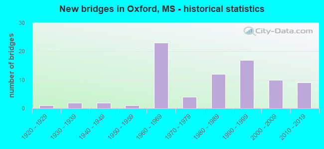
- New bridges - historical statistics
- 11920-1929
- 21930-1939
- 21940-1949
- 11950-1959
- 231960-1969
- 41970-1979
- 121980-1989
- 171990-1999
- 102000-2009
- 92010-2019
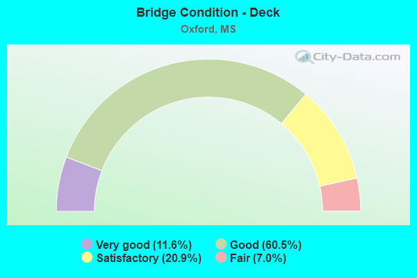
- Bridge Condition - Deck
- 11.6%Very good
- 60.5%Good
- 20.9%Satisfactory
- 7.0%Fair
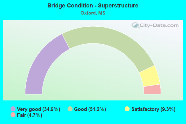
- Bridge Condition - Superstructure
- 34.9%Very good
- 51.2%Good
- 9.3%Satisfactory
- 4.7%Fair
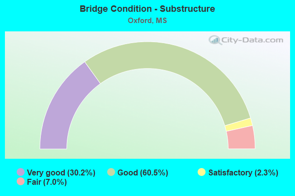
- Bridge Condition - Substructure
- 30.2%Very good
- 60.5%Good
- 2.3%Satisfactory
- 7.0%Fair
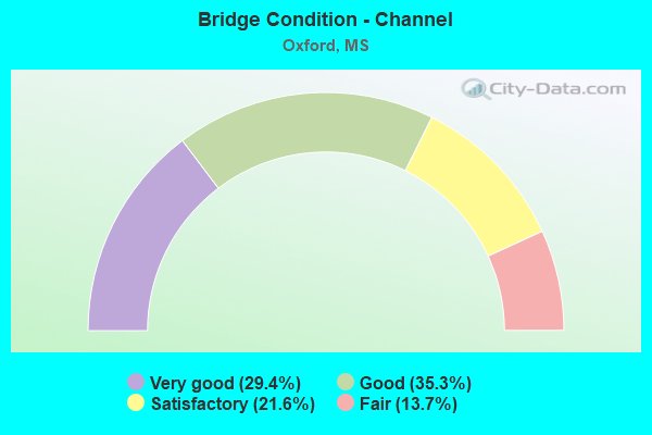
- Bridge Condition - Channel
- 29.4%Very good
- 35.3%Good
- 21.6%Satisfactory
- 13.7%Fair
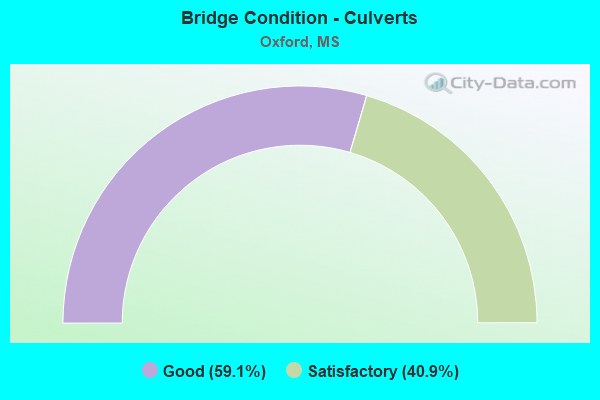
- Bridge Condition - Culverts
- 59.1%Good
- 40.9%Satisfactory
Find on map >> Show street view
Structure Number: SA3600000000064, Location: SEC 25 T 8S R 4W (Lat: 34.361917, Lng: -89.567147), Route carried "on" structure: City street 9425, Year Built: 2002, Status: Open, Structure Length: 2.85m (9.35ft), Average Daily Traffic: 23,000 (year 2020), Truck Traffic: 12%, Average Future Daily Traffic: 34,500 (year 2040), Design Load: HS 20, Features Intersected: GOOSE VALLEY CREEK SPUR, Facility Carried by Structure: JACKSON EXT
Minimum Vertical Clearance: 30+ m (98+ ft), Kilometerpoint: 0.321, Lanes on structure: 2, Owner: City or Municipal Highway Agency, Approaching Roadway Width: 20.1m (65.9ft), Material/Design: Concrete, Design/Construction: Channel Beam, Number Of Spans In Main Unit: 3, Length of Maximum Span: 9.5m (31.2ft), Curb or Sidewalk Widths: Left: 2.8m (9.2ft), Right: 2.8m (9.2ft), Curb-To-Curb Width: 19.5m (64.0ft), Out-to-Out Width: 25.1m (82.3ft)
Condition: Deck: Good, Superstructure: Good, Substructure: Good, Channel: Good, Operating Rating: 73.2 metric tons, Method Used To Determine Operating Rating: Load Factor (LF) rating reported by rating factor (RF) method using MS18 loading, Inventory Rating: 43.7 metric tons, Method Used To Determine Inventory Rating: Load Factor (LF) rating reported by rating factor (RF) method using MS18 loading, Structural Evaluation: Better than present minimum criteria, Deck Geometry: Superior to present desirable criteria, Waterway Adequacy: Superior to present desirable criteria, Approach Roadway Alignment: Equal to present desirable criteria, Designated Inspection Frequency: Every 24 months, Inspection Date: Febuary 2021, Deck Structure Type: Concrete Precast Panels, Wearing Surface/Protective System: Wearing Surface: Monolithic Concrete
Find on map >> Show street view
Structure Number: SA3600000000065, Location: SEC 25 T 8S R 4W (Lat: 34.362233, Lng: -89.563806), Route carried "on" structure: City street 9425, Year Built: 2001, Status: Open, Structure Length: 2.11m (6.92ft), Average Daily Traffic: 23,000 (year 2018), Truck Traffic: 12%, Average Future Daily Traffic: 34,500 (year 2038), Design Load: HS 20, Features Intersected: GOOSE VALLEY CREEK, Facility Carried by Structure: JACKSON AVE EXT
Minimum Vertical Clearance: 30+ m (98+ ft), Kilometerpoint: 0.643, Lanes on structure: 2, Owner: City or Municipal Highway Agency, Approaching Roadway Width: 20.1m (65.9ft), Material/Design: Concrete, Design/Construction: Channel Beam, Number Of Spans In Main Unit: 3, Length of Maximum Span: 9.5m (31.2ft), Curb or Sidewalk Widths: Left: 2.3m (7.5ft), Right: 2.3m (7.5ft), Curb-To-Curb Width: 19.4m (63.6ft), Out-to-Out Width: 25.1m (82.3ft)
Condition: Deck: Good, Superstructure: Good, Substructure: Good, Channel: Very good, Operating Rating: 70.0 metric tons, Method Used To Determine Operating Rating: Load Factor (LF) rating reported by rating factor (RF) method using MS18 loading, Inventory Rating: 41.8 metric tons, Method Used To Determine Inventory Rating: Load Factor (LF) rating reported by rating factor (RF) method using MS18 loading, Structural Evaluation: Better than present minimum criteria, Deck Geometry: Superior to present desirable criteria, Waterway Adequacy: Superior to present desirable criteria, Approach Roadway Alignment: Equal to present desirable criteria, Designated Inspection Frequency: Every 24 months, Inspection Date: Febuary 2021, Deck Structure Type: Concrete Precast Panels, Wearing Surface/Protective System: Wearing Surface: Monolithic Concrete
Find on map >> Show street view
Structure Number: SA3600000000066, Location: SEC 25 T 8S R 4W (Lat: 34.363372, Lng: -89.565239), Route carried "on" structure: Spur City street 639, Year Built: 2000, Status: Open, Structure Length: 1.74m (5.71ft), Average Daily Traffic: 1,500 (year 2020), Truck Traffic: 4%, Average Future Daily Traffic: 2,250 (year 2040), Design Load: HS 20, Features Intersected: CREEK, Facility Carried by Structure: HOME DEPOT DRIVE
Minimum Vertical Clearance: 30+ m (98+ ft), Kilometerpoint: 0.000, Lanes on structure: 2, Owner: City or Municipal Highway Agency, Approaching Roadway Width: 7.3m (24.0ft), Material/Design: Concrete, Design/Construction: Channel Beam, Number Of Spans In Main Unit: 3, Length of Maximum Span: 5.8m (19.0ft), Curb or Sidewalk Widths: Left: 0.4m (1.3ft), Right: 0.4m (1.3ft), Curb-To-Curb Width: 8.9m (29.2ft), Out-to-Out Width: 9.4m (30.8ft)
Condition: Deck: Good, Superstructure: Good, Substructure: Good, Channel: Very good, Operating Rating: 88.5 metric tons, Method Used To Determine Operating Rating: Load Factor (LF) rating reported by rating factor (RF) method using MS18 loading, Inventory Rating: 53.1 metric tons, Method Used To Determine Inventory Rating: Load Factor (LF) rating reported by rating factor (RF) method using MS18 loading, Structural Evaluation: Better than present minimum criteria, Deck Geometry: Somewhat better than minimum adequacy, Waterway Adequacy: Superior to present desirable criteria, Approach Roadway Alignment: Equal to present desirable criteria, Length Of Structure Improvement: 2.69m (8.83ft), Designated Inspection Frequency: Every 24 months, Inspection Date: Febuary 2021, Bridge Improvement Cost: $220,000, Roadway Improvement Cost: $55,000, Total Project Cost: $330,000 ( Estimate for 2018), Deck Structure Type: Concrete Precast Panels, Wearing Surface/Protective System: Wearing Surface: Monolithic Concrete
Find on map >> Show street view
Structure Number: SA360000000007, Location: SEC 32 T 8S R 4W (Lat: 34.348342, Lng: -89.647133), Route carried "on" structure: County highway 177, Year Built: 2001, Status: Open, Structure Length: 2.84m (9.32ft), Average Daily Traffic: 70 (year 2018), Truck Traffic: 8%, Average Future Daily Traffic: 105 (year 2038), Design Load: HS 20, Features Intersected: SPUR OF CLEAR CREEK, Facility Carried by Structure: CO.ROAD 311
Minimum Vertical Clearance: 30+ m (98+ ft), Kilometerpoint: 5.471, Lanes on structure: 2, Owner: County Highway Agency, Approaching Roadway Width: 7.9m (25.9ft), Skew: 3 degrees, Material/Design: Concrete, Design/Construction: Channel Beam, Number Of Spans In Main Unit: 3, Length of Maximum Span: 9.5m (31.2ft), Curb or Sidewalk Widths: Left: 0.2m (0.7ft), Right: 0.2m (0.7ft), Curb-To-Curb Width: 8.2m (26.9ft), Out-to-Out Width: 8.6m (28.2ft)
Condition: Deck: Good, Superstructure: Good, Substructure: Very good, Channel: Good, Operating Rating: 74.8 metric tons, Method Used To Determine Operating Rating: Load Factor (LF) rating reported by rating factor (RF) method using MS18 loading, Inventory Rating: 45.0 metric tons, Method Used To Determine Inventory Rating: Load Factor (LF) rating reported by rating factor (RF) method using MS18 loading, Structural Evaluation: Better than present minimum criteria, Deck Geometry: Equal to present minimum criteria, Waterway Adequacy: Superior to present desirable criteria, Approach Roadway Alignment: Equal to present desirable criteria, Designated Inspection Frequency: Every 24 months, Inspection Date: Febuary 2021, Deck Structure Type: Concrete Precast Panels, Wearing Surface/Protective System: Wearing Surface: Monolithic Concrete
Find on map >> Show street view
Structure Number: SA3600000000094, Location: SEC 4 T 9S R 3W (Lat: 34.334294, Lng: -89.513511), Route carried "on" structure: City street 702, Year Built: 1980, Status: Open, Structure Length: 3.66m (12.01ft), Average Daily Traffic: 600 (year 2018), Truck Traffic: 8%, Average Future Daily Traffic: 900 (year 2038), Design Load: HS 20, Features Intersected: BURNEY BRANCH, Facility Carried by Structure: INDUSTRIAL PARK DR
Minimum Vertical Clearance: 30+ m (98+ ft), Kilometerpoint: 0.000, Lanes on structure: 2, Owner: City or Municipal Highway Agency, Approaching Roadway Width: 14.6m (47.9ft), Material/Design: Prestressed concrete, Design/Construction: Stringer/Multi-beam, Number Of Spans In Main Unit: 3, Length of Maximum Span: 12.2m (40.0ft), Curb or Sidewalk Widths: Left: 0.2m (0.7ft), Right: 0.2m (0.7ft), Curb-To-Curb Width: 8.5m (27.9ft), Out-to-Out Width: 9.1m (29.9ft)
Condition: Deck: Good, Superstructure: Very good, Substructure: Very good, Channel: Fair, Operating Rating: 74.5 metric tons, Method Used To Determine Operating Rating: Load Factor (LF) rating reported by rating factor (RF) method using MS18 loading, Inventory Rating: 34.0 metric tons, Method Used To Determine Inventory Rating: Load Factor (LF) rating reported by rating factor (RF) method using MS18 loading, Structural Evaluation: Equal to present desirable criteria, Deck Geometry: Somewhat better than minimum adequacy, Waterway Adequacy: Superior to present desirable criteria, Approach Roadway Alignment: Equal to present desirable criteria, Length Of Structure Improvement: 4.24m (13.91ft), Designated Inspection Frequency: Every 24 months, Inspection Date: Febuary 2020, Bridge Improvement Cost: $487,000, Roadway Improvement Cost: $122,000, Total Project Cost: $731,000 ( Estimate for 2018), Deck Structure Type: Concrete Cast-file-Place, Wearing Surface/Protective System: Wearing Surface: Monolithic Concrete
Find on map >> Show street view
Structure Number: SA3600000000095, Location: SEC 5 T 9S R 3W (Lat: 34.329381, Lng: -89.526031), Route carried "on" structure: City street 3024, Year Built: 2003, Status: Open, Structure Length: 0.61m (2.00ft), Average Daily Traffic: 60 (year 2018), Average Future Daily Traffic: 90 (year 2038), Design Load: HS 20, Features Intersected: CREEK
Minimum Vertical Clearance: 30+ m (98+ ft), Kilometerpoint: 0.482, Lanes on structure: 2, Owner: City or Municipal Highway Agency, Approaching Roadway Width: 10.6m (34.8ft), Material/Design: Concrete, Design/Construction: Culvert, Number Of Spans In Main Unit: 1, Length of Maximum Span: 6.1m (20.0ft)
Condition: Channel: Good, Culverts: Good, Operating Rating: 55.7 metric tons, Method Used To Determine Operating Rating: Load Factor (LF) rating reported by rating factor (RF) method using MS18 loading, Inventory Rating: 33.4 metric tons, Method Used To Determine Inventory Rating: Load Factor (LF) rating reported by rating factor (RF) method using MS18 loading, Structural Evaluation: Better than present minimum criteria, Waterway Adequacy: Equal to present desirable criteria, Approach Roadway Alignment: Equal to present desirable criteria, Designated Inspection Frequency: Every 24 months, Inspection Date: Febuary 2020
Find on map >> Show street view
Structure Number: SA3600000000096, Location: SEC 13 T 9S R 3W B (Lat: 34.292472, Lng: -89.464194), Route carried "on" structure: County highway 847, Year Built: 1983, Status: Open, Structure Length: 0.79m (2.59ft), Average Daily Traffic: 810 (year 2018), Truck Traffic: 5%, Average Future Daily Traffic: 1,400 (year 2038), Design Load: HS 20, Features Intersected: 847 OVER UN-NAMED CREEK, Facility Carried by Structure: CO.ROAD 418
Minimum Vertical Clearance: 30+ m (98+ ft), Kilometerpoint: 5.954, Lanes on structure: 2, Owner: County Highway Agency, Approaching Roadway Width: 9.1m (29.9ft), Material/Design: Concrete, Design/Construction: Culvert, Number Of Spans In Main Unit: 2, Length of Maximum Span: 3.7m (12.1ft)
Condition: Channel: Fair, Culverts: Good, Operating Rating: 65.8 metric tons, Method Used To Determine Operating Rating: Load Factor (LF) rating reported by rating factor (RF) method using MS18 loading, Inventory Rating: 39.5 metric tons, Method Used To Determine Inventory Rating: Load Factor (LF) rating reported by rating factor (RF) method using MS18 loading, Structural Evaluation: Better than present minimum criteria, Waterway Adequacy: Equal to present minimum criteria, Approach Roadway Alignment: Equal to present desirable criteria, Designated Inspection Frequency: Every 24 months, Inspection Date: Febuary 2020
Find on map >> Show street view
Structure Number: SA3600000000097, Location: SEC 14 T 9S R 3W B (Lat: 34.292422, Lng: -89.486581), Route carried "on" structure: County highway 847, Year Built: 1982, Status: Open, Structure Length: 5.55m (18.21ft), Average Daily Traffic: 810 (year 2018), Truck Traffic: 5%, Average Future Daily Traffic: 1,400 (year 2038), Design Load: HS 20, Features Intersected: 847 OVER YELLOW LEAF CK, Facility Carried by Structure: CO.ROAD 418
Minimum Vertical Clearance: 30+ m (98+ ft), Kilometerpoint: 3.862, Lanes on structure: 2, Owner: County Highway Agency, Approaching Roadway Width: 9.1m (29.9ft), Material/Design: Prestressed concrete, Design/Construction: Stringer/Multi-beam, Number Of Spans In Main Unit: 1, Number Of Approach Spans: 3, Length of Maximum Span: 24.4m (80.1ft), Curb or Sidewalk Widths: Left: 0.2m (0.7ft), Right: 0.2m (0.7ft), Curb-To-Curb Width: 8.5m (27.9ft), Out-to-Out Width: 9.4m (30.8ft)
Condition: Deck: Good, Superstructure: Very good, Substructure: Good, Channel: Satisfactory, Operating Rating: 61.2 metric tons, Method Used To Determine Operating Rating: Load Factor (LF) rating reported by rating factor (RF) method using MS18 loading, Inventory Rating: 34.0 metric tons, Method Used To Determine Inventory Rating: Load Factor (LF) rating reported by rating factor (RF) method using MS18 loading, Structural Evaluation: Better than present minimum criteria, Deck Geometry: Somewhat better than minimum adequacy, Waterway Adequacy: Superior to present desirable criteria, Approach Roadway Alignment: Equal to present desirable criteria, Designated Inspection Frequency: Every 24 months, Inspection Date: Febuary 2020, Deck Structure Type: Concrete Cast-file-Place, Wearing Surface/Protective System: Wearing Surface: Monolithic Concrete
Find on map >> Show street view
Structure Number: SA3600000000098, Location: SEC 16 T 9S R 3W B (Lat: 34.301333, Lng: -89.515700), Route carried "on" structure: County highway 32, Year Built: 1960, Status: Open, Structure Length: 0.73m (2.40ft), Average Daily Traffic: 1,400 (year 2018), Truck Traffic: 3%, Average Future Daily Traffic: 2,100 (year 2038), Design Load: HS 20, Features Intersected: SPUR OF BURNEY BRANCH, Facility Carried by Structure: CO.ROAD 401
Minimum Vertical Clearance: 30+ m (98+ ft), Kilometerpoint: 1.770, Lanes on structure: 2, Owner: County Highway Agency, Approaching Roadway Width: 9.1m (29.9ft), Material/Design: Concrete, Design/Construction: Culvert, Number Of Spans In Main Unit: 2, Length of Maximum Span: 3.6m (11.8ft)
Condition: Channel: Good, Culverts: Satisfactory, Operating Rating: 54.1 metric tons, Method Used To Determine Operating Rating: Load Factor (LF) rating reported by rating factor (RF) method using MS18 loading, Inventory Rating: 32.4 metric tons, Method Used To Determine Inventory Rating: Load Factor (LF) rating reported by rating factor (RF) method using MS18 loading, Structural Evaluation: Equal to present minimum criteria, Waterway Adequacy: Superior to present desirable criteria, Approach Roadway Alignment: Equal to present desirable criteria, Designated Inspection Frequency: Every 24 months, Inspection Date: Febuary 2020
Find on map >> Show street view
Structure Number: SA3600000000101, Location: SEC 22 T 9S R 3W B (Lat: 34.287892, Lng: -89.507386), Route carried "on" structure: County highway 847, Year Built: 1959, Status: Posted for load, Structure Length: 4.15m (13.62ft), Average Daily Traffic: 810 (year 2014), Truck Traffic: 5%, Average Future Daily Traffic: 1,400 (year 2034), Design Load: HS 15, Features Intersected: 847 OVER BURNEY BRANCH, Facility Carried by Structure: CO.ROAD 418
Minimum Vertical Clearance: 30+ m (98+ ft), Kilometerpoint: 1.770, Lanes on structure: 2, Owner: County Highway Agency, Approaching Roadway Width: 6.4m (21.0ft), Material/Design: Steel, Design/Construction: Stringer/Multi-beam, Number Of Spans In Main Unit: 1, Number Of Approach Spans: 4, Length of Maximum Span: 18.3m (60.0ft), Curb or Sidewalk Widths: Left: 0.4m (1.3ft), Right: 0.4m (1.3ft), Curb-To-Curb Width: 6.7m (22.0ft), Out-to-Out Width: 7.5m (24.6ft)
Condition: Deck: Fair, Superstructure: Satisfactory, Substructure: Fair, Channel: Good, Operating Rating: 24.1 metric tons, Method Used To Determine Operating Rating: Load Factor (LF), Inventory Rating: 14.3 metric tons, Method Used To Determine Inventory Rating: Load Factor (LF), Structural Evaluation: Meets minimum limits, Deck Geometry: Meets minimum limits, Waterway Adequacy: Superior to present desirable criteria, Approach Roadway Alignment: Somewhat better than minimum adequacy, Bridge Posting: Required (Relationship of Operating Rating to Maximum Legal Load: 30.0 - 39.9% below), Length Of Structure Improvement: 5.43m (17.81ft), Designated Inspection Frequency: Every 12 months, Inspection Date: December 2021, Bridge Improvement Cost: $293,000, Roadway Improvement Cost: $73,000, Total Project Cost: $440,000, Deck Structure Type: Concrete Cast-file-Place, Wearing Surface/Protective System: Wearing Surface: Monolithic Concrete
Find on map >> Show street view
Structure Number: SA3600000000102, Location: SEC 27 T 9S R 3W (Lat: 34.268558, Lng: -89.499039), Route carried "on" structure: County highway 117, Year Built: 2002, Status: Open, Structure Length: 3.72m (12.20ft), Average Daily Traffic: 110 (year 2020), Truck Traffic: 2%, Average Future Daily Traffic: 165 (year 2040), Design Load: HS 20, Features Intersected: MURRAY CREEK, Facility Carried by Structure: CO.ROAD 420
Minimum Vertical Clearance: 30+ m (98+ ft), Kilometerpoint: 3.218, Lanes on structure: 2, Owner: County Highway Agency, Approaching Roadway Width: 7.9m (25.9ft), Material/Design: Prestressed concrete, Design/Construction: Stringer/Multi-beam, Number Of Spans In Main Unit: 3, Length of Maximum Span: 18.3m (60.0ft), Curb or Sidewalk Widths: Left: 0.4m (1.3ft), Right: 0.4m (1.3ft), Curb-To-Curb Width: 7.9m (25.9ft), Out-to-Out Width: 8.7m (28.5ft)
Condition: Deck: Satisfactory, Superstructure: Very good, Substructure: Good, Channel: Satisfactory, Operating Rating: 60.6 metric tons, Method Used To Determine Operating Rating: Load Factor (LF) rating reported by rating factor (RF) method using MS18 loading, Inventory Rating: 35.6 metric tons, Method Used To Determine Inventory Rating: Load Factor (LF) rating reported by rating factor (RF) method using MS18 loading, Structural Evaluation: Better than present minimum criteria, Deck Geometry: Somewhat better than minimum adequacy, Waterway Adequacy: Equal to present desirable criteria, Approach Roadway Alignment: Equal to present desirable criteria, Designated Inspection Frequency: Every 24 months, Inspection Date: January 2022, Deck Structure Type: Concrete Cast-file-Place, Wearing Surface/Protective System: Wearing Surface: Monolithic Concrete
Find on map >> Show street view
Structure Number: SA3600000000189, Location: SEC 20 T 8S R 3W (Lat: 34.378106, Lng: -89.541528), Route carried "on" structure: City street 9423, Year Built: 2006, Status: Open, Structure Length: 2.83m (9.28ft), Average Daily Traffic: 7,700 (year 2018), Truck Traffic: 8%, Average Future Daily Traffic: 11,550 (year 2038), Design Load: HS 20, Features Intersected: STREAM, Facility Carried by Structure: COLLEGE HILL ROAD
Minimum Vertical Clearance: 30+ m (98+ ft), Kilometerpoint: 1.100, Lanes on structure: 3, Owner: City or Municipal Highway Agency, Approaching Roadway Width: 17.0m (55.8ft), Skew: 3 degrees, Material/Design: Concrete, Design/Construction: Channel Beam, Number Of Spans In Main Unit: 3, Length of Maximum Span: 9.4m (30.8ft), Curb or Sidewalk Widths: Left: 2.8m (9.2ft), Right: 2.8m (9.2ft), Curb-To-Curb Width: 12.5m (41.0ft), Out-to-Out Width: 18.2m (59.7ft)
Condition: Deck: Good, Superstructure: Good, Substructure: Good, Channel: Very good, Operating Rating: 62.5 metric tons, Method Used To Determine Operating Rating: Load Factor (LF) rating reported by rating factor (RF) method using MS18 loading, Inventory Rating: 37.6 metric tons, Method Used To Determine Inventory Rating: Load Factor (LF) rating reported by rating factor (RF) method using MS18 loading, Structural Evaluation: Better than present minimum criteria, Deck Geometry: Meets minimum limits, Waterway Adequacy: Equal to present desirable criteria, Approach Roadway Alignment: Equal to present desirable criteria, Length Of Structure Improvement: 2.83m (9.28ft), Designated Inspection Frequency: Every 24 months, Inspection Date: Febuary 2020, Bridge Improvement Cost: $232,000, Roadway Improvement Cost: $58,000, Total Project Cost: $348,000 ( Estimate for 2018), Deck Structure Type: Concrete Precast Panels, Wearing Surface/Protective System: Wearing Surface: Monolithic Concrete
Find on map >> Show street view
Structure Number: SA3600000000194, Location: SEC 33 T 8S R 4W (Lat: 34.339517, Lng: -89.626281), Route carried "on" structure: Spur County highway 175, Year Built: 2011, Status: Open, Structure Length: 1.14m (3.74ft), Average Daily Traffic: 110 (year 2020), Truck Traffic: 8%, Average Future Daily Traffic: 165 (year 2040), Design Load: HS 20, Features Intersected: CREEK, Facility Carried by Structure: CR 309
Minimum Vertical Clearance: 30+ m (98+ ft), Kilometerpoint: 24.140, Lanes on structure: 2, Owner: County Highway Agency, Approaching Roadway Width: 5.5m (18.0ft), Skew: 4 degrees, Material/Design: Concrete, Design/Construction: Culvert, Number Of Spans In Main Unit: 2, Length of Maximum Span: 3.7m (12.1ft)
Condition: Channel: Fair, Culverts: Satisfactory, Operating Rating: 71.3 metric tons, Method Used To Determine Operating Rating: Load Factor (LF) rating reported by rating factor (RF) method using MS18 loading, Inventory Rating: 42.8 metric tons, Method Used To Determine Inventory Rating: Load Factor (LF) rating reported by rating factor (RF) method using MS18 loading, Structural Evaluation: Equal to present minimum criteria, Waterway Adequacy: Better than present minimum criteria, Approach Roadway Alignment: Equal to present desirable criteria, Designated Inspection Frequency: Every 24 months, Inspection Date: January 2022
Find on map >> Show street view
Structure Number: SA3600000000198, Location: SEC 30 T 8S R 3W (Lat: 34.361133, Lng: -89.561264), Route carried "on" structure: City street , Year Built: 2009, Status: Open, Structure Length: 1.52m (4.99ft), Average Daily Traffic: 150 (year 2018), Truck Traffic: 10%, Average Future Daily Traffic: 300 (year 2038), Design Load: HS 20, Features Intersected: GOOSE VALLEY CREEK, Facility Carried by Structure: MALL DRIVE
Minimum Vertical Clearance: 30+ m (98+ ft), Kilometerpoint: 0.000, Lanes on structure: 2, Owner: City or Municipal Highway Agency, Approaching Roadway Width: 5.5m (18.0ft), Material/Design: Concrete, Design/Construction: Channel Beam, Number Of Spans In Main Unit: 2, Length of Maximum Span: 9.4m (30.8ft), Curb or Sidewalk Widths: Left: 0.2m (0.7ft), Right: 0.2m (0.7ft), Curb-To-Curb Width: 8.9m (29.2ft), Out-to-Out Width: 9.4m (30.8ft)
Condition: Deck: Good, Superstructure: Good, Substructure: Good, Channel: Very good, Operating Rating: 59.3 metric tons, Method Used To Determine Operating Rating: Load Factor (LF) rating reported by rating factor (RF) method using MS18 loading, Inventory Rating: 35.6 metric tons, Method Used To Determine Inventory Rating: Load Factor (LF) rating reported by rating factor (RF) method using MS18 loading, Structural Evaluation: Better than present minimum criteria, Deck Geometry: Equal to present minimum criteria, Waterway Adequacy: Better than present minimum criteria, Approach Roadway Alignment: Equal to present desirable criteria, Designated Inspection Frequency: Every 24 months, Inspection Date: Febuary 2020, Deck Structure Type: Concrete Precast Panels, Wearing Surface/Protective System: Wearing Surface: Monolithic Concrete
Find on map >> Show street view
Structure Number: SA3600000000201, Location: SEC 33 T 8S R 3W (Lat: 34.347347, Lng: -89.523453), Route carried "on" structure: City street , Year Built: 2013, Status: Open, Structure Length: 1.55m (5.09ft), Average Daily Traffic: 400 (year 2018), Truck Traffic: 8%, Average Future Daily Traffic: 1,000 (year 2038), Design Load: HS 20, Features Intersected: BURNEY BRANCH CREEK, Facility Carried by Structure: BELK DRIVE EXT
Minimum Vertical Clearance: 30+ m (98+ ft), Kilometerpoint: 0.209, Lanes on structure: 4, Owner: City or Municipal Highway Agency, Approaching Roadway Width: 9.1m (29.9ft), Skew: 37 degrees, Material/Design: Concrete, Design/Construction: Culvert, Number Of Spans In Main Unit: 3, Length of Maximum Span: 4.9m (16.1ft), Curb or Sidewalk Widths: Left: 0.2m (0.7ft), Right: 0.2m (0.7ft), Curb-To-Curb Width: 9.1m (29.9ft), Out-to-Out Width: 9.1m (29.9ft)
Condition: Channel: Good, Culverts: Satisfactory, Operating Rating: 97.2 metric tons, Method Used To Determine Operating Rating: Load Factor (LF) rating reported by rating factor (RF) method using MS18 loading, Inventory Rating: 58.6 metric tons, Method Used To Determine Inventory Rating: Load Factor (LF) rating reported by rating factor (RF) method using MS18 loading, Structural Evaluation: Equal to present minimum criteria, Deck Geometry: High priority of replacement, Waterway Adequacy: Better than present minimum criteria, Approach Roadway Alignment: Better than present minimum criteria, Designated Inspection Frequency: Every 24 months, Inspection Date: Febuary 2021
Find on map >> Show street view
Structure Number: SA3600000000202, Location: SEC 28 T 8S R 3W (Lat: 34.357117, Lng: -89.511072), Route carried "on" structure: City street , Year Built: 2016, Status: Open, Structure Length: 1.65m (5.41ft), Average Daily Traffic: 100 (year 2016), Truck Traffic: 2%, Average Future Daily Traffic: 200 (year 2036), Design Load: HS 20, Features Intersected: BURNEY BRANCH, Facility Carried by Structure: JOHNSON AV.
Minimum Vertical Clearance: 30+ m (98+ ft), Kilometerpoint: 0.000, Lanes on structure: 2, Owner: City or Municipal Highway Agency, Approaching Roadway Width: 7.6m (24.9ft), Material/Design: Steel, Design/Construction: Stringer/Multi-beam, Number Of Spans In Main Unit: 1, Length of Maximum Span: 16.5m (54.1ft), Curb or Sidewalk Widths: Left: 1.6m (5.2ft), Right: 1.6m (5.2ft), Curb-To-Curb Width: 6.7m (22.0ft), Out-to-Out Width: 10.0m (32.8ft)
Condition: Deck: Good, Superstructure: Satisfactory, Substructure: Very good, Channel: Very good, Operating Rating: 42.2 metric tons, Method Used To Determine Operating Rating: Allowable Stress (AS), Inventory Rating: 25.2 metric tons, Method Used To Determine Inventory Rating: Allowable Stress (AS), Structural Evaluation: Equal to present minimum criteria, Deck Geometry: Somewhat better than minimum adequacy, Waterway Adequacy: Better than present minimum criteria, Approach Roadway Alignment: Equal to present minimum criteria, Designated Inspection Frequency: Every 24 months, Inspection Date: June 2021, Deck Structure Type: Concrete Cast-file-Place, Wearing Surface/Protective System: Wearing Surface: Monolithic Concrete
Find on map >> Show street view
Structure Number: SA3600000000203, Location: SEC 24 T 8S R 4W (Lat: 34.372650, Lng: -89.571892), Route carried "on" structure: City street , Year Built: 2018, Status: Open, Structure Length: 3.72m (12.20ft), Average Daily Traffic: 2,000 (year 2018), Truck Traffic: 5%, Average Future Daily Traffic: 3,000 (year 2038), Design Load: HL 93, Features Intersected: EAST GOOSE VALLEY CREEK, Facility Carried by Structure: WEST OXFORD LOOP
Minimum Vertical Clearance: 30+ m (98+ ft), Kilometerpoint: 0.535, Lanes on structure: 2, Owner: City or Municipal Highway Agency, Approaching Roadway Width: 13.4m (44.0ft), Material/Design: Prestressed concrete, Design/Construction: Stringer/Multi-beam, Number Of Spans In Main Unit: 3, Length of Maximum Span: 18.3m (60.0ft), Curb or Sidewalk Widths: Left: 2.6m (8.5ft), Right: 2.6m (8.5ft), Curb-To-Curb Width: 14.3m (46.9ft), Out-to-Out Width: 20.4m (66.9ft)
Condition: Deck: Good, Superstructure: Very good, Substructure: Good, Channel: Very good, Operating Rating: 51.5 metric tons, Method Used To Determine Operating Rating: Load and Resistance Factor Rating (LRFR) rating reported by rating factor(RF) method using HL-93 loadings, Inventory Rating: 39.5 metric tons, Method Used To Determine Inventory Rating: Load and Resistance Factor Rating (LRFR) rating reported by rating factor(RF) method using HL-93 loadings, Structural Evaluation: Better than present minimum criteria, Deck Geometry: Superior to present desirable criteria, Waterway Adequacy: Equal to present desirable criteria, Approach Roadway Alignment: Equal to present desirable criteria, Designated Inspection Frequency: Every 24 months, Inspection Date: Febuary 2020, Deck Structure Type: Concrete Cast-file-Place, Wearing Surface/Protective System: Wearing Surface: Monolithic Concrete
Find on map >> Show street view
Structure Number: SA3600000000204, Location: SEC 12 T 8S R 4W (Lat: 34.396422, Lng: -89.579739), Route carried "on" structure: City street , Year Built: 2019, Status: Open, Structure Length: 5.49m (18.01ft), Average Daily Traffic: 2,000 (year 2018), Truck Traffic: 5%, Average Future Daily Traffic: 3,000 (year 2038), Design Load: HL 93, Features Intersected: DAVIDISON CREEK, Facility Carried by Structure: WEST OXFORD LOOP
Minimum Vertical Clearance: 30+ m (98+ ft), Kilometerpoint: 3.416, Lanes on structure: 2, Owner: City or Municipal Highway Agency, Approaching Roadway Width: 13.4m (44.0ft), Material/Design: Prestressed concrete, Design/Construction: Stringer/Multi-beam, Number Of Spans In Main Unit: 3, Length of Maximum Span: 30.5m (100.1ft), Curb-To-Curb Width: 13.4m (44.0ft), Out-to-Out Width: 14.3m (46.9ft)
Condition: Deck: Good, Superstructure: Very good, Substructure: Good, Channel: Very good, Operating Rating: 52.2 metric tons, Method Used To Determine Operating Rating: Load and Resistance Factor Rating (LRFR) rating reported by rating factor(RF) method using HL-93 loadings, Inventory Rating: 36.6 metric tons, Method Used To Determine Inventory Rating: Load and Resistance Factor Rating (LRFR) rating reported by rating factor(RF) method using HL-93 loadings, Structural Evaluation: Better than present minimum criteria, Deck Geometry: Equal to present desirable criteria, Waterway Adequacy: Equal to present desirable criteria, Approach Roadway Alignment: Equal to present desirable criteria, Designated Inspection Frequency: Every 24 months, Inspection Date: Febuary 2020, Deck Structure Type: Concrete Cast-file-Place, Wearing Surface/Protective System: Wearing Surface: Monolithic Concrete
Find on map >> Show street view
Structure Number: SA3600000000205, Location: SEC 1 T 8S R 4W (Lat: 34.410725, Lng: -89.568419), Route carried "on" structure: County highway , Year Built: 2018, Status: Open, Structure Length: 1.66m (5.45ft), Average Daily Traffic: 2,000 (year 2018), Truck Traffic: 5%, Average Future Daily Traffic: 3,000 (year 2038), Design Load: HL 93, Features Intersected: BERRY BRANCH, Facility Carried by Structure: WEST OXFORD LOOP
Minimum Vertical Clearance: 30+ m (98+ ft), Kilometerpoint: 5.346, Lanes on structure: 2, Owner: County Highway Agency, Approaching Roadway Width: 13.4m (44.0ft), Skew: 4 degrees, Material/Design: Concrete, Design/Construction: Culvert, Number Of Spans In Main Unit: 2, Length of Maximum Span: 5.5m (18.0ft)
Condition: Channel: Very good, Culverts: Good, Operating Rating: 43.2 metric tons, Method Used To Determine Operating Rating: Allowable Stress (AS), Inventory Rating: 32.4 metric tons, Method Used To Determine Inventory Rating: Allowable Stress (AS), Structural Evaluation: Better than present minimum criteria, Waterway Adequacy: Better than present minimum criteria, Approach Roadway Alignment: Equal to present desirable criteria, Designated Inspection Frequency: Every 24 months, Inspection Date: Febuary 2020
Find on map >> Show street view
Structure Number: SA3600000000206, Location: SEC 1 T 8S R 4W (Lat: 34.414194, Lng: -89.564664), Route carried "on" structure: County highway , Year Built: 2018, Status: Open, Structure Length: 2.68m (8.79ft), Average Daily Traffic: 2,000 (year 2018), Truck Traffic: 5%, Average Future Daily Traffic: 3,000 (year 2038), Design Load: HL 93, Features Intersected: BERRY BRANCH, Facility Carried by Structure: WEST OXFORD LOOP
Minimum Vertical Clearance: 30+ m (98+ ft), Kilometerpoint: 5.932, Lanes on structure: 2, Owner: County Highway Agency, Approaching Roadway Width: 13.4m (44.0ft), Skew: 6 degrees, Material/Design: Concrete, Design/Construction: Culvert, Number Of Spans In Main Unit: 2, Length of Maximum Span: 5.5m (18.0ft)
Condition: Channel: Very good, Culverts: Good, Operating Rating: 43.2 metric tons, Method Used To Determine Operating Rating: Allowable Stress (AS), Inventory Rating: 32.4 metric tons, Method Used To Determine Inventory Rating: Allowable Stress (AS), Structural Evaluation: Better than present minimum criteria, Waterway Adequacy: Better than present minimum criteria, Approach Roadway Alignment: Equal to present desirable criteria, Designated Inspection Frequency: Every 24 months, Inspection Date: Febuary 2020
Find on map >> Show street view
Structure Number: SA360000000A058, Location: SEC 3 T 8S R 4W (Lat: 34.422058, Lng: -89.614328), Route carried "on" structure: County highway 29, Year Built: 2019, Status: Open, Structure Length: 10.15m (33.30ft), Average Daily Traffic: 510 (year 2018), Truck Traffic: 8%, Average Future Daily Traffic: 765 (year 2038), Design Load: HL 93, Features Intersected: TOBY TUBBY, Facility Carried by Structure: CO.ROAD 100
Minimum Vertical Clearance: 30+ m (98+ ft), Kilometerpoint: 9.012, Lanes on structure: 2, Owner: County Highway Agency, Approaching Roadway Width: 9.1m (29.9ft), Material/Design: Prestressed concrete, Design/Construction: Stringer/Multi-beam, Number Of Spans In Main Unit: 6, Length of Maximum Span: 24.4m (80.1ft), Curb-To-Curb Width: 7.9m (25.9ft), Out-to-Out Width: 8.8m (28.9ft)
Condition: Deck: Good, Superstructure: Very good, Substructure: Good, Channel: Very good, Operating Rating: 49.9 metric tons, Method Used To Determine Operating Rating: Load and Resistance Factor Rating (LRFR) rating reported by rating factor(RF) method using HL-93 loadings, Inventory Rating: 34.3 metric tons, Method Used To Determine Inventory Rating: Load and Resistance Factor Rating (LRFR) rating reported by rating factor(RF) method using HL-93 loadings, Structural Evaluation: Better than present minimum criteria, Deck Geometry: Somewhat better than minimum adequacy, Waterway Adequacy: Somewhat better than minimum adequacy, Approach Roadway Alignment: Equal to present desirable criteria, Designated Inspection Frequency: Every 24 months, Inspection Date: Febuary 2020, Deck Structure Type: Concrete Cast-file-Place, Wearing Surface/Protective System: Wearing Surface: Monolithic Concrete
Find on map >> Show street view
Structure Number: SA360000000A061, Location: SEC 8 T 8S R 4W (Lat: 34.399069, Lng: -89.635528), Route carried "on" structure: Spur County highway 175, Year Built: 2016, Status: Open, Structure Length: 0.81m (2.66ft), Average Daily Traffic: 60 (year 2018), Average Future Daily Traffic: 90 (year 2038), Design Load: HS 20, Features Intersected: CREEK, Facility Carried by Structure: CO.ROAD 107
Minimum Vertical Clearance: 30+ m (98+ ft), Kilometerpoint: 11.104, Lanes on structure: 2, Owner: County Highway Agency, Approaching Roadway Width: 7.6m (24.9ft), Skew: 1 degrees, Material/Design: Concrete, Design/Construction: Culvert, Number Of Spans In Main Unit: 2, Length of Maximum Span: 3.6m (11.8ft)
Condition: Channel: Good, Culverts: Satisfactory, Operating Rating: 62.5 metric tons, Method Used To Determine Operating Rating: Load Factor (LF) rating reported by rating factor (RF) method using MS18 loading, Inventory Rating: 37.3 metric tons, Method Used To Determine Inventory Rating: Load Factor (LF) rating reported by rating factor (RF) method using MS18 loading, Structural Evaluation: Equal to present minimum criteria, Waterway Adequacy: Better than present minimum criteria, Approach Roadway Alignment: Equal to present desirable criteria, Designated Inspection Frequency: Every 24 months, Inspection Date: Febuary 2021
Find on map >> Show street view
Structure Number: 31000070361181A, Location: SR 7 OVER US 278 (Lat: 34.354061, Lng: -89.508681), Route carried "under" structure: State highway 278, Year Built: 1967, Structure Length: 0. m, Average Daily Traffic: 13,500 (year 2017), Truck Traffic: 8%, Features Intersected: US 278, Facility Carried by Structure: SR 7
Minimum Vertical Clearance: 5.44m (17.85ft), Kilometerpoint: 19.829, Lanes on structure: 2, Lanes under structure: 4, Material/Design: Prestressed concrete, Design/Construction: Stringer/Multi-beam, Length of Maximum Span: 18.3m (60.0ft)
Find on map >> Show street view
Structure Number: 31000070361181A, Location: SR 7 OVER US 278 (Lat: 34.354231, Lng: -89.508619), Route carried "under" structure: State highway 278, Year Built: 1967, Structure Length: 0. m, Average Daily Traffic: 13,500 (year 2017), Truck Traffic: 8%, Features Intersected: US 278, Facility Carried by Structure: SR 7
Minimum Vertical Clearance: 5.46m (17.91ft), Kilometerpoint: 25.304, Lanes on structure: 2, Lanes under structure: 4, Material/Design: Prestressed concrete, Design/Construction: Stringer/Multi-beam, Length of Maximum Span: 18.3m (60.0ft)
Find on map >> Show street view
Structure Number: 31000070361181B, Location: SR 7 OVER US 278 (Lat: 34.354061, Lng: -89.508461), Route carried "under" structure: State highway 278, Year Built: 1967, Structure Length: 0. m, Average Daily Traffic: 12,500 (year 2017), Truck Traffic: 8%, Features Intersected: US 278, Facility Carried by Structure: SR 7
Minimum Vertical Clearance: 4.98m (16.34ft), Kilometerpoint: 19.848, Lanes on structure: 2, Lanes under structure: 4, Material/Design: Prestressed concrete, Design/Construction: Stringer/Multi-beam, Length of Maximum Span: 18.3m (60.0ft)
Find on map >> Show street view
Structure Number: 31000070361181B, Location: SR 7 OVER US 278 (Lat: 34.354231, Lng: -89.508400), Route carried "under" structure: State highway 278, Year Built: 1967, Structure Length: 0. m, Average Daily Traffic: 12,500 (year 2017), Truck Traffic: 8%, Features Intersected: US 278, Facility Carried by Structure: SR 7
Minimum Vertical Clearance: 5.05m (16.57ft), Kilometerpoint: 25.283, Lanes on structure: 2, Lanes under structure: 4, Material/Design: Prestressed concrete, Design/Construction: Stringer/Multi-beam, Length of Maximum Span: 18.3m (60.0ft)
Find on map >> Show street view
Structure Number: 31000300360005A, Location: SR 30 OVER SR 7 (Lat: 34.384700, Lng: -89.496939), Route carried "under" structure: State highway 7, Year Built: 1982, Structure Length: 0. m, Average Daily Traffic: 10,000 (year 2017), Truck Traffic: 5%, Features Intersected: SR 7, Facility Carried by Structure: SR 30
Minimum Vertical Clearance: 5.44m (17.85ft), Kilometerpoint: 26.841, Lanes on structure: 3, Lanes under structure: 4, Material/Design: Prestressed concrete continuous, Design/Construction: Stringer/Multi-beam, Length of Maximum Span: 23.8m (78.1ft)
Find on map >> Show street view
Structure Number: 31000300360005A, Location: SR 30 OVER SR 7 (Lat: 34.384750, Lng: -89.497131), Route carried "under" structure: State highway 7, Year Built: 1982, Structure Length: 0. m, Average Daily Traffic: 10,000 (year 2017), Truck Traffic: 5%, Features Intersected: SR 7, Facility Carried by Structure: SR 30
Minimum Vertical Clearance: 5.51m (18.08ft), Kilometerpoint: 0.916, Lanes on structure: 3, Lanes under structure: 4, Material/Design: Prestressed concrete continuous, Design/Construction: Stringer/Multi-beam, Length of Maximum Span: 23.8m (78.1ft)
Find on map >> Show street view
Structure Number: 31000300360005B, Location: SR 30 OVER SR 7 (Lat: 34.384469, Lng: -89.496969), Route carried "under" structure: State highway 7, Year Built: 1982, Structure Length: 0. m, Average Daily Traffic: 10,000 (year 2017), Truck Traffic: 5%, Features Intersected: SR 7, Facility Carried by Structure: SR 30
Minimum Vertical Clearance: 5.15m (16.90ft), Kilometerpoint: 26.815, Lanes on structure: 3, Lanes under structure: 4, Material/Design: Prestressed concrete continuous, Design/Construction: Stringer/Multi-beam, Length of Maximum Span: 23.8m (78.1ft)
Find on map >> Show street view
Structure Number: 31000300360005B, Location: SR 30 OVER SR 7 (Lat: 34.384511, Lng: -89.497161), Route carried "under" structure: State highway 7, Year Built: 1982, Structure Length: 0. m, Average Daily Traffic: 10,000 (year 2017), Truck Traffic: 5%, Features Intersected: SR 7, Facility Carried by Structure: SR 30
Minimum Vertical Clearance: 5.22m (17.13ft), Kilometerpoint: 0.941, Lanes on structure: 3, Lanes under structure: 4, Material/Design: Prestressed concrete continuous, Design/Construction: Stringer/Multi-beam, Length of Maximum Span: 23.8m (78.1ft)
Find on map >> Show street view
Structure Number: 31003340360005, Location: SR 334 OVER SR 6 (Lat: 34.355539, Lng: -89.497839), Route carried "under" structure: State highway 6, Year Built: 1992, Structure Length: 0. m, Average Daily Traffic: 7,500 (year 2017), Truck Traffic: 13%, Features Intersected: SR 6, Facility Carried by Structure: SR 334
Minimum Vertical Clearance: 5.05m (16.57ft), Kilometerpoint: 20.859, Lanes on structure: 3, Lanes under structure: 6, Material/Design: Prestressed concrete continuous, Design/Construction: Stringer/Multi-beam, Length of Maximum Span: 24.4m (80.1ft)
Find on map >> Show street view
Structure Number: 31003340360005, Location: SR 334 OVER SR 6 (Lat: 34.355711, Lng: -89.497911), Route carried "under" structure: State highway 6, Year Built: 1992, Structure Length: 0. m, Average Daily Traffic: 7,500 (year 2017), Truck Traffic: 13%, Features Intersected: SR 6, Facility Carried by Structure: SR 334
Minimum Vertical Clearance: 5.08m (16.67ft), Kilometerpoint: 24.285, Lanes on structure: 3, Lanes under structure: 6, Material/Design: Prestressed concrete continuous, Design/Construction: Stringer/Multi-beam, Length of Maximum Span: 24.4m (80.1ft)
Find on map >> Show street view
Structure Number: 41000060360748, Location: 2.0 MI W SR 7 (Lat: 34.356969, Lng: -89.544050), Route carried "under" structure: State highway 6, Year Built: 1963, Structure Length: 0. m, Average Daily Traffic: 15,000 (year 2017), Truck Traffic: 13%, Features Intersected: SR 6, Facility Carried by Structure: COLISEUM DRIVE
Minimum Vertical Clearance: 5.08m (16.67ft), Kilometerpoint: 16.534, Lanes on structure: 2, Lanes under structure: 4, Material/Design: Prestressed concrete, Design/Construction: Stringer/Multi-beam, Length of Maximum Span: 18.3m (60.0ft)
Find on map >> Show street view
Structure Number: 41000060360748, Location: 2.0 MI W SR 7 (Lat: 34.357150, Lng: -89.544050), Route carried "under" structure: State highway 6, Year Built: 1963, Structure Length: 0. m, Average Daily Traffic: 15,000 (year 2017), Truck Traffic: 13%, Features Intersected: SR 6, Facility Carried by Structure: COLISEUM DRIVE
Minimum Vertical Clearance: 5.08m (16.67ft), Kilometerpoint: 28.603, Lanes on structure: 2, Lanes under structure: 4, Material/Design: Prestressed concrete, Design/Construction: Stringer/Multi-beam, Length of Maximum Span: 18.3m (60.0ft)
Find on map >> Show street view
Structure Number: 41000060360754, Location: 1.3 MI W SR 7 (Lat: 34.355200, Lng: -89.532811), Route carried "under" structure: State highway 6, Year Built: 1963, Structure Length: 0. m, Average Daily Traffic: 18,000 (year 2017), Truck Traffic: 13%, Features Intersected: SR 6, Facility Carried by Structure: OLD TAYLOR ROAD
Minimum Vertical Clearance: 5.13m (16.83ft), Kilometerpoint: 17.593, Lanes on structure: 4, Lanes under structure: 4, Material/Design: Prestressed concrete, Design/Construction: Stringer/Multi-beam, Length of Maximum Span: 18.3m (60.0ft)
Find on map >> Show street view
Structure Number: 41000060360754, Location: 1.3 MI W SR 7 (Lat: 34.355369, Lng: -89.532750), Route carried "under" structure: State highway 6, Year Built: 1963, Structure Length: 0. m, Average Daily Traffic: 18,000 (year 2017), Truck Traffic: 13%, Features Intersected: SR 6, Facility Carried by Structure: OLD TAYLOR ROAD
Minimum Vertical Clearance: 4.95m (16.24ft), Kilometerpoint: 27.537, Lanes on structure: 4, Lanes under structure: 4, Material/Design: Prestressed concrete, Design/Construction: Stringer/Multi-beam, Length of Maximum Span: 18.3m (60.0ft)
Find on map >> Show street view
Structure Number: 41000060360762, Location: 0.7 MI W SR 7 (Lat: 34.354300, Lng: -89.521231), Route carried "under" structure: State highway 6, Year Built: 1961, Structure Length: 0. m, Average Daily Traffic: 18,000 (year 2017), Truck Traffic: 13%, Features Intersected: SR 6, Facility Carried by Structure: S LAMAR BLVD
Minimum Vertical Clearance: 5.19m (17.03ft), Kilometerpoint: 26.464, Lanes on structure: 2, Lanes under structure: 4, Material/Design: Concrete continuous, Design/Construction: Box Beam or Girders - Single/Spread, Length of Maximum Span: 20.4m (66.9ft)
Find on map >> Show street view
Structure Number: 41000060360762, Location: 0.7 MI W SR 7 (Lat: 34.354131, Lng: -89.521250), Route carried "under" structure: State highway 6, Year Built: 1961, Structure Length: 0. m, Average Daily Traffic: 18,000 (year 2017), Truck Traffic: 13%, Features Intersected: SR 6, Facility Carried by Structure: S LAMAR BLVD
Minimum Vertical Clearance: 4.99m (16.37ft), Kilometerpoint: 18.673, Lanes on structure: 2, Lanes under structure: 4, Material/Design: Concrete continuous, Design/Construction: Box Beam or Girders - Single/Spread, Length of Maximum Span: 20.4m (66.9ft)