Bridge Statistics for Ozark, Alabama (AL)
Condition, Traffic, Stress, Structural Evaluation, Project Costs
- National Bridge Inventory (NBI) Statistics
- 46Number of bridges
- 486ft / 148mTotal length
- $48,978,000Total costs
- 107,046Total average daily traffic
- 12,058Total average daily truck traffic
- 149,588Total future (year 2033) average daily traffic
- National Bridge Inventory (NBI) Registered Bridges for Ozark
- No street view available for this location
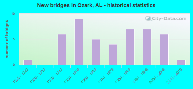
- New bridges - historical statistics
- 11920-1929
- 61940-1949
- 91950-1959
- 51960-1969
- 41970-1979
- 71980-1989
- 71990-1999
- 62000-2009
- 12010-2019
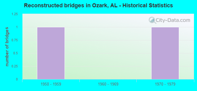
- Reconstructed bridges - Historical Statistics
- 11950-1959
- 01960-1969
- 11970-1979
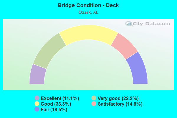
- Bridge Condition - Deck
- 11.1%Excellent
- 22.2%Very good
- 33.3%Good
- 14.8%Satisfactory
- 18.5%Fair
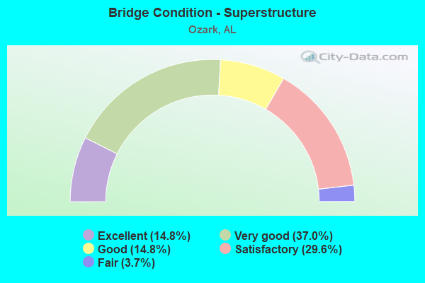
- Bridge Condition - Superstructure
- 14.8%Excellent
- 37.0%Very good
- 14.8%Good
- 29.6%Satisfactory
- 3.7%Fair
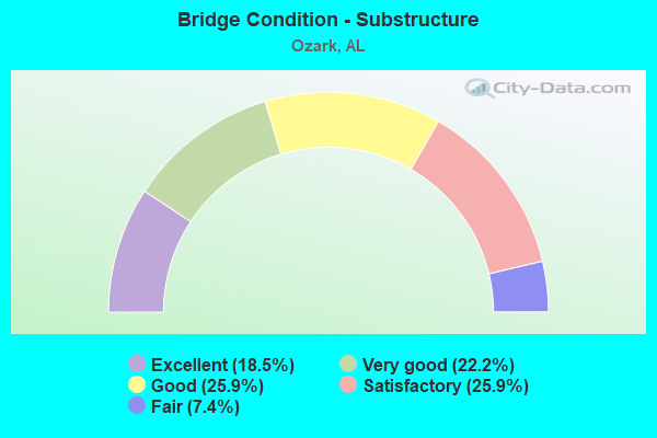
- Bridge Condition - Substructure
- 18.5%Excellent
- 22.2%Very good
- 25.9%Good
- 25.9%Satisfactory
- 7.4%Fair
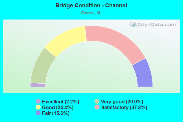
- Bridge Condition - Channel
- 2.2%Excellent
- 20.0%Very good
- 24.4%Good
- 37.8%Satisfactory
- 15.6%Fair
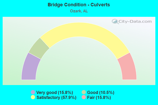
- Bridge Condition - Culverts
- 15.8%Very good
- 10.5%Good
- 57.9%Satisfactory
- 15.8%Fair
Find on map >> Show street view
Structure Number: 2862, Location: .2 MI.S.DALE CO 54 (Lat: 31.513267, Lng: -85.573800), Route carried "on" structure: State highway 105, Year Built: 1945, Status: Open, Structure Length: 11.43m (37.50ft), Average Daily Traffic: 1,850 (year 2013), Truck Traffic: 2%, Average Future Daily Traffic: 2,448 (year 2033), Design Load: H 15, Features Intersected: JUDAH CREEK
Minimum Vertical Clearance: 30+ m (98+ ft), Kilometerpoint: 8.407, Lanes on structure: 2, Owner: State Highway Agency, Approaching Roadway Width: 10.7m (35.1ft), Material/Design: Steel, Design/Construction: Stringer/Multi-beam, Number Of Spans In Main Unit: 11, Length of Maximum Span: 10.4m (34.1ft), Curb or Sidewalk Widths: Left: 0.5m (1.6ft), Right: 0.5m (1.6ft), Curb-To-Curb Width: 7.2m (23.6ft), Out-to-Out Width: 8.5m (27.9ft)
Condition: Deck: Satisfactory, Superstructure: Fair, Substructure: Fair, Channel: Satisfactory, Operating Rating: 34.0 metric tons, Method Used To Determine Operating Rating: Load Factor (LF), Inventory Rating: 20.4 metric tons, Method Used To Determine Inventory Rating: Load Factor (LF), Structural Evaluation: Somewhat better than minimum adequacy, Deck Geometry: High priority of corrective action, Waterway Adequacy: Equal to present desirable criteria, Approach Roadway Alignment: Equal to present desirable criteria, Length Of Structure Improvement: 12.30m (40.35ft), Designated Inspection Frequency: Every 24 months, Inspection Date: October 2020, Bridge Improvement Cost: $2,278,000, Roadway Improvement Cost: $228,000, Total Project Cost: $2,506,000 ( Estimate for 2022), Deck Structure Type: Concrete Cast-file-Place
Find on map >> Show street view
Structure Number: 3095, Location: SEC-8 T-6-N R-25-E (Lat: 31.514611, Lng: -85.565664), Route carried "on" structure: County highway 54, Year Built: 1947, Status: Posted for load, Structure Length: 2.56m (8.40ft), Average Daily Traffic: 391 (year 2002), Truck Traffic: 6%, Average Future Daily Traffic: 581 (year 2034), Design Load: H 15, Features Intersected: COTTON CREEK
Minimum Vertical Clearance: 30+ m (98+ ft), Kilometerpoint: 0.000, Lanes on structure: 2, Owner: County Highway Agency, Approaching Roadway Width: 8.5m (27.9ft), Material/Design: Concrete, Design/Construction: Tee Beam, Number Of Spans In Main Unit: 3, Length of Maximum Span: 10.4m (34.1ft), Curb-To-Curb Width: 6.7m (22.0ft), Out-to-Out Width: 7.6m (24.9ft)
Condition: Deck: Good, Superstructure: Good, Substructure: Good, Channel: Satisfactory, Operating Rating: 36.7 metric tons, Method Used To Determine Operating Rating: Allowable Stress (AS), Inventory Rating: 23.0 metric tons, Method Used To Determine Inventory Rating: Allowable Stress (AS), Structural Evaluation: Equal to present minimum criteria, Deck Geometry: Meets minimum limits, Waterway Adequacy: Equal to present minimum criteria, Approach Roadway Alignment: Better than present minimum criteria, Bridge Posting: Required (Relationship of Operating Rating to Maximum Legal Load: 0.1 - 9.9% below), Length Of Structure Improvement: 3.46m (11.35ft), Designated Inspection Frequency: Every 24 months, Other Special Inspection Frequency: Every 12 months, Inspection Date: October 2020, Other Special Inspection Date: October 2021, Bridge Improvement Cost: $569,000, Roadway Improvement Cost: $57,000, Total Project Cost: $626,000 ( Estimate for 2022), Deck Structure Type: Concrete Cast-file-Place
Find on map >> Show street view
Structure Number: 3328, Location: 1.3 MI.N SR. 27 (Lat: 31.466628, Lng: -85.609528), Route carried "on" structure: State highway 105, Year Built: 1948, Status: Open, Structure Length: 1.60m (5.25ft), Average Daily Traffic: 4,160 (year 2013), Truck Traffic: 4%, Average Future Daily Traffic: 5,504 (year 2033), Design Load: HS 20, Features Intersected: BRANCH
Minimum Vertical Clearance: 30+ m (98+ ft), Kilometerpoint: 2.037, Lanes on structure: 2, Owner: State Highway Agency, Approaching Roadway Width: 10.7m (35.1ft), Material/Design: Concrete, Design/Construction: Culvert, Number Of Spans In Main Unit: 5, Length of Maximum Span: 3.0m (9.8ft)
Condition: Channel: Satisfactory, Culverts: Satisfactory, Operating Rating: 39.7 metric tons, Method Used To Determine Operating Rating: Load Factor (LF), Inventory Rating: 23.9 metric tons, Method Used To Determine Inventory Rating: Load Factor (LF), Structural Evaluation: Equal to present minimum criteria, Waterway Adequacy: Equal to present desirable criteria, Approach Roadway Alignment: Equal to present desirable criteria, Length Of Structure Improvement: 2.29m (7.51ft), Designated Inspection Frequency: Every 24 months, Inspection Date: November 2020, Bridge Improvement Cost: $463,000, Roadway Improvement Cost: $46,000, Total Project Cost: $509,000 ( Estimate for 2022)
Find on map >> Show street view
Structure Number: 3329, Location: 1.6 MI.N.SR 27 (Lat: 31.469183, Lng: -85.604650), Route carried "on" structure: State highway 105, Year Built: 1948, Status: Open, Structure Length: 1.02m (3.35ft), Average Daily Traffic: 4,160 (year 2013), Truck Traffic: 4%, Average Future Daily Traffic: 5,504 (year 2033), Design Load: HS 20, Features Intersected: BRANCH
Minimum Vertical Clearance: 30+ m (98+ ft), Kilometerpoint: 2.609, Lanes on structure: 2, Owner: State Highway Agency, Approaching Roadway Width: 10.7m (35.1ft), Material/Design: Concrete, Design/Construction: Culvert, Number Of Spans In Main Unit: 4, Length of Maximum Span: 2.4m (7.9ft)
Condition: Channel: Satisfactory, Culverts: Satisfactory, Operating Rating: 73.5 metric tons, Method Used To Determine Operating Rating: Load Factor (LF), Inventory Rating: 44.1 metric tons, Method Used To Determine Inventory Rating: Load Factor (LF), Structural Evaluation: Equal to present minimum criteria, Waterway Adequacy: Equal to present desirable criteria, Approach Roadway Alignment: Equal to present desirable criteria, Length Of Structure Improvement: 1.70m (5.58ft), Designated Inspection Frequency: Every 24 months, Inspection Date: November 2020, Bridge Improvement Cost: $343,000, Roadway Improvement Cost: $34,000, Total Project Cost: $377,000 ( Estimate for 2022)
Find on map >> Show street view
Structure Number: 333, Location: 3.3 MI.N.SR. 27 (Lat: 31.488817, Lng: -85.590750), Route carried "on" structure: State highway 105, Year Built: 1948, Status: Open, Structure Length: 0.63m (2.07ft), Average Daily Traffic: 3,030 (year 2013), Truck Traffic: 6%, Average Future Daily Traffic: 4,009 (year 2033), Design Load: HS 20, Features Intersected: BRANCH
Minimum Vertical Clearance: 30+ m (98+ ft), Kilometerpoint: 5.209, Lanes on structure: 2, Owner: State Highway Agency, Approaching Roadway Width: 11.0m (36.1ft), Material/Design: Concrete, Design/Construction: Culvert, Number Of Spans In Main Unit: 2, Length of Maximum Span: 3.0m (9.8ft)
Condition: Channel: Fair, Culverts: Fair, Operating Rating: 57.2 metric tons, Method Used To Determine Operating Rating: Load Factor (LF), Inventory Rating: 34.3 metric tons, Method Used To Determine Inventory Rating: Load Factor (LF), Structural Evaluation: Somewhat better than minimum adequacy, Waterway Adequacy: Equal to present desirable criteria, Approach Roadway Alignment: Equal to present desirable criteria, Length Of Structure Improvement: 1.24m (4.07ft), Designated Inspection Frequency: Every 24 months, Inspection Date: November 2020, Bridge Improvement Cost: $258,000, Roadway Improvement Cost: $26,000, Total Project Cost: $284,000 ( Estimate for 2022)
Find on map >> Show street view
Structure Number: 3331, Location: 4 MI. N. JCT. SR. 27 (Lat: 31.496983, Lng: -85.582833), Route carried "on" structure: State highway 105, Year Built: 1948, Status: Open, Structure Length: 1.62m (5.31ft), Average Daily Traffic: 3,030 (year 2013), Truck Traffic: 6%, Average Future Daily Traffic: 4,009 (year 2033), Design Load: HS 20, Features Intersected: SEVEN MILE CREEK
Minimum Vertical Clearance: 30+ m (98+ ft), Kilometerpoint: 6.389, Lanes on structure: 2, Owner: State Highway Agency, Approaching Roadway Width: 10.7m (35.1ft), Material/Design: Concrete, Design/Construction: Culvert, Number Of Spans In Main Unit: 5, Length of Maximum Span: 3.0m (9.8ft)
Condition: Channel: Satisfactory, Culverts: Satisfactory, Operating Rating: 88.9 metric tons, Method Used To Determine Operating Rating: Load Factor (LF), Inventory Rating: 60.7 metric tons, Method Used To Determine Inventory Rating: Load Factor (LF), Structural Evaluation: Equal to present minimum criteria, Waterway Adequacy: Equal to present desirable criteria, Approach Roadway Alignment: Equal to present desirable criteria, Length Of Structure Improvement: 2.30m (7.55ft), Designated Inspection Frequency: Every 24 months, Inspection Date: November 2020, Bridge Improvement Cost: $465,000, Roadway Improvement Cost: $47,000, Total Project Cost: $512,000 ( Estimate for 2022)
Find on map >> Show street view
Structure Number: 4356, Location: SEC-30 T-6-N R-25-E (Lat: 31.463350, Lng: -85.572164), Route carried "on" structure: County highway 36, Year Built: 1952, Status: Posted for load, Structure Length: 9.27m (30.41ft), Average Daily Traffic: 1,790 (year 2004), Truck Traffic: 6%, Average Future Daily Traffic: 2,660 (year 2034), Design Load: H 15, Features Intersected: JUDY CREEK
Minimum Vertical Clearance: 30+ m (98+ ft), Kilometerpoint: 0.000, Lanes on structure: 2, Owner: County Highway Agency, Approaching Roadway Width: 9.1m (29.9ft), Material/Design: Concrete, Design/Construction: Tee Beam, Number Of Spans In Main Unit: 8, Length of Maximum Span: 15.2m (49.9ft), Curb-To-Curb Width: 6.7m (22.0ft), Out-to-Out Width: 7.7m (25.3ft)
Condition: Deck: Good, Superstructure: Good, Substructure: Good, Channel: Good, Operating Rating: 35.7 metric tons, Method Used To Determine Operating Rating: Load Factor (LF), Inventory Rating: 21.4 metric tons, Method Used To Determine Inventory Rating: Load Factor (LF), Structural Evaluation: Somewhat better than minimum adequacy, Deck Geometry: High priority of corrective action, Waterway Adequacy: Equal to present minimum criteria, Approach Roadway Alignment: Equal to present desirable criteria, Bridge Posting: Required (Relationship of Operating Rating to Maximum Legal Load: 0.1 - 9.9% below), Length Of Structure Improvement: 10.23m (33.56ft), Designated Inspection Frequency: Every 24 months, Other Special Inspection Frequency: Every 12 months, Inspection Date: November 2021, Other Special Inspection Date: November 2021, Bridge Improvement Cost: $1,753,000, Roadway Improvement Cost: $175,000, Total Project Cost: $1,928,000 ( Estimate for 2022), Deck Structure Type: Concrete Cast-file-Place
Find on map >> Show street view
Structure Number: 4357, Location: SEC-30 T-6-N R-25-E (Lat: 31.462500, Lng: -85.575203), Route carried "on" structure: County highway 36, Year Built: 1952, Status: Posted for load, Structure Length: 5.18m (16.99ft), Average Daily Traffic: 1,790 (year 2004), Truck Traffic: 6%, Average Future Daily Traffic: 2,660 (year 2034), Design Load: H 15, Features Intersected: JUDY CREEK
Minimum Vertical Clearance: 30+ m (98+ ft), Kilometerpoint: 0.000, Lanes on structure: 2, Owner: County Highway Agency, Approaching Roadway Width: 9.1m (29.9ft), Material/Design: Concrete, Design/Construction: Tee Beam, Number Of Spans In Main Unit: 5, Length of Maximum Span: 10.4m (34.1ft), Curb-To-Curb Width: 6.7m (22.0ft), Out-to-Out Width: 7.7m (25.3ft)
Condition: Deck: Good, Superstructure: Good, Substructure: Good, Channel: Very good, Operating Rating: 35.7 metric tons, Method Used To Determine Operating Rating: Load Factor (LF), Inventory Rating: 21.4 metric tons, Method Used To Determine Inventory Rating: Load Factor (LF), Structural Evaluation: Somewhat better than minimum adequacy, Deck Geometry: High priority of corrective action, Waterway Adequacy: Equal to present minimum criteria, Approach Roadway Alignment: Better than present minimum criteria, Bridge Posting: Required (Relationship of Operating Rating to Maximum Legal Load: 0.1 - 9.9% below), Length Of Structure Improvement: 6.20m (20.34ft), Designated Inspection Frequency: Every 24 months, Other Special Inspection Frequency: Every 12 months, Inspection Date: November 2021, Other Special Inspection Date: November 2021, Bridge Improvement Cost: $1,063,000, Roadway Improvement Cost: $106,000, Total Project Cost: $1,169,000 ( Estimate for 2022), Deck Structure Type: Concrete Cast-file-Place
Find on map >> Show street view
Structure Number: 5385, Location: 3 MI. N. SR 134 (Lat: 31.388617, Lng: -85.608283), Route carried "on" structure: State highway 123, Year Built: 1926, Year Reconstructed: 1956, Status: Open, Structure Length: 1.62m (5.31ft), Average Daily Traffic: 4,210 (year 2013), Truck Traffic: 4%, Average Future Daily Traffic: 6,015 (year 2033), Design Load: H 15, Features Intersected: KLONDIKE CREEK
Minimum Vertical Clearance: 30+ m (98+ ft), Kilometerpoint: 39.340, Lanes on structure: 2, Owner: State Highway Agency, Approaching Roadway Width: 10.7m (35.1ft), Material/Design: Concrete, Design/Construction: Tee Beam, Number Of Spans In Main Unit: 2, Length of Maximum Span: 7.9m (25.9ft), Curb or Sidewalk Widths: Left: 0.5m (1.6ft), Right: 0.2m (0.7ft), Curb-To-Curb Width: 8.5m (27.9ft), Out-to-Out Width: 9.3m (30.5ft)
Condition: Deck: Satisfactory, Superstructure: Satisfactory, Substructure: Satisfactory, Channel: Satisfactory, Operating Rating: 42.2 metric tons, Method Used To Determine Operating Rating: Load Factor (LF), Inventory Rating: 25.3 metric tons, Method Used To Determine Inventory Rating: Load Factor (LF), Structural Evaluation: Equal to present minimum criteria, Deck Geometry: Meets minimum limits, Waterway Adequacy: Equal to present desirable criteria, Approach Roadway Alignment: Equal to present desirable criteria, Length Of Structure Improvement: 2.30m (7.55ft), Designated Inspection Frequency: Every 24 months, Inspection Date: April 2021, Bridge Improvement Cost: $473,000, Roadway Improvement Cost: $47,000, Total Project Cost: $520,000 ( Estimate for 2022), Deck Structure Type: Concrete Cast-file-Place, Wearing Surface/Protective System: Wearing Surface: Bituminous
Find on map >> Show street view
Structure Number: 5532, Location: JCT. US-231 * SR-27 (Lat: 31.458417, Lng: -85.667450), Route carried "on" structure: US 231, Year Built: 1956, Status: Open, Structure Length: 3.11m (10.20ft), Average Daily Traffic: 9,325 (year 2011), Truck Traffic: 18%, Average Future Daily Traffic: 13,505 (year 2033), Design Load: HS 20, Features Intersected: LITTLE CLAYBANK CREEK
Minimum Vertical Clearance: 30+ m (98+ ft), Kilometerpoint: 71.957, Lanes on structure: 2, Base Highway Network: Yes, Owner: State Highway Agency, Approaching Roadway Width: 13.7m (44.9ft), Skew: 10 degrees, Material/Design: Concrete, Design/Construction: Tee Beam, Number Of Spans In Main Unit: 3, Length of Maximum Span: 10.4m (34.1ft), Curb or Sidewalk Widths: Left: 0.5m (1.6ft), Right: 0.5m (1.6ft), Curb-To-Curb Width: 8.5m (27.9ft), Out-to-Out Width: 10.1m (33.1ft)
Condition: Deck: Satisfactory, Superstructure: Satisfactory, Substructure: Satisfactory, Channel: Satisfactory, Operating Rating: 58.0 metric tons, Method Used To Determine Operating Rating: Allowable Stress (AS), Inventory Rating: 36.6 metric tons, Method Used To Determine Inventory Rating: Allowable Stress (AS), Structural Evaluation: Equal to present minimum criteria, Deck Geometry: High priority of corrective action, Waterway Adequacy: Better than present minimum criteria, Approach Roadway Alignment: Equal to present desirable criteria, Length Of Structure Improvement: 3.96m (12.99ft), Designated Inspection Frequency: Every 24 months, Inspection Date: April 2020, Bridge Improvement Cost: $896,000, Roadway Improvement Cost: $90,000, Total Project Cost: $986,000 ( Estimate for 2022), Deck Structure Type: Concrete Cast-file-Place
Find on map >> Show street view
Structure Number: 5533, Location: JCT. US-231 * SR-27 (Lat: 31.458300, Lng: -85.667583), Route carried "on" structure: US 231, Year Built: 1956, Status: Open, Structure Length: 3.11m (10.20ft), Average Daily Traffic: 9,305 (year 2013), Truck Traffic: 4%, Average Future Daily Traffic: 13,505 (year 2033), Design Load: HS 20, Features Intersected: LITTLE CLAYBANK CREEK
Minimum Vertical Clearance: 30+ m (98+ ft), Kilometerpoint: 71.957, Lanes on structure: 2, Base Highway Network: Yes, Owner: State Highway Agency, Approaching Roadway Width: 13.7m (44.9ft), Skew: 10 degrees, Material/Design: Concrete, Design/Construction: Tee Beam, Number Of Spans In Main Unit: 3, Length of Maximum Span: 10.4m (34.1ft), Curb or Sidewalk Widths: Left: 0.5m (1.6ft), Right: 0.5m (1.6ft), Curb-To-Curb Width: 8.5m (27.9ft), Out-to-Out Width: 10.1m (33.1ft)
Condition: Deck: Fair, Superstructure: Satisfactory, Substructure: Satisfactory, Channel: Satisfactory, Operating Rating: 58.0 metric tons, Method Used To Determine Operating Rating: Allowable Stress (AS), Inventory Rating: 36.6 metric tons, Method Used To Determine Inventory Rating: Allowable Stress (AS), Structural Evaluation: Equal to present minimum criteria, Deck Geometry: High priority of corrective action, Waterway Adequacy: Better than present minimum criteria, Approach Roadway Alignment: Equal to present desirable criteria, Length Of Structure Improvement: 3.96m (12.99ft), Designated Inspection Frequency: Every 24 months, Inspection Date: April 2020, Bridge Improvement Cost: $896,000, Roadway Improvement Cost: $90,000, Total Project Cost: $986,000 ( Estimate for 2022), Deck Structure Type: Concrete Cast-file-Place
Find on map >> Show street view
Structure Number: 5536, Location: SEC-10 T-5-N R-24-E (Lat: 31.415000, Lng: -85.638333), Route carried "on" structure: County highway 29, Year Built: 1956, Status: Open, Structure Length: 1.31m (4.30ft), Average Daily Traffic: 975 (year 2012), Truck Traffic: 9%, Average Future Daily Traffic: 1,365 (year 2034), Design Load: H 15, Features Intersected: HURRICANE CREEK, Facility Carried by Structure: LAKEVIEW ROAD
Minimum Vertical Clearance: 30+ m (98+ ft), Kilometerpoint: 0.000, Lanes on structure: 2, Owner: City or Municipal Highway Agency, Approaching Roadway Width: 7.9m (25.9ft), Material/Design: Concrete, Design/Construction: Culvert, Number Of Spans In Main Unit: 4, Length of Maximum Span: 3.0m (9.8ft)
Condition: Channel: Satisfactory, Culverts: Satisfactory, Operating Rating: 79.7 metric tons, Method Used To Determine Operating Rating: Load Factor (LF), Inventory Rating: 47.9 metric tons, Method Used To Determine Inventory Rating: Load Factor (LF), Structural Evaluation: Equal to present minimum criteria, Waterway Adequacy: Equal to present minimum criteria, Approach Roadway Alignment: Equal to present minimum criteria, Length Of Structure Improvement: 1.98m (6.50ft), Designated Inspection Frequency: Every 24 months, Inspection Date: December 2020, Bridge Improvement Cost: $424,000, Roadway Improvement Cost: $42,000, Total Project Cost: $466,000 ( Estimate for 2022)
Find on map >> Show street view
Structure Number: 5571, Location: 3.2 MI. N. SR 27 (Lat: 31.501717, Lng: -85.695867), Route carried "on" structure: US 231, Year Built: 1956, Status: Open, Structure Length: 5.18m (16.99ft), Average Daily Traffic: 6,600 (year 2013), Truck Traffic: 22%, Average Future Daily Traffic: 8,579 (year 2033), Design Load: HS 20, Features Intersected: BEAR CREEK
Minimum Vertical Clearance: 30+ m (98+ ft), Kilometerpoint: 77.406, Lanes on structure: 2, Base Highway Network: Yes, Owner: State Highway Agency, Approaching Roadway Width: 12.2m (40.0ft), Skew: 10 degrees, Material/Design: Concrete, Design/Construction: Tee Beam, Number Of Spans In Main Unit: 5, Length of Maximum Span: 10.4m (34.1ft), Curb or Sidewalk Widths: Left: 0.5m (1.6ft), Right: 0.5m (1.6ft), Curb-To-Curb Width: 8.5m (27.9ft), Out-to-Out Width: 10.1m (33.1ft)
Condition: Deck: Fair, Superstructure: Satisfactory, Substructure: Satisfactory, Channel: Fair, Operating Rating: 48.4 metric tons, Method Used To Determine Operating Rating: Load Factor (LF), Inventory Rating: 29.0 metric tons, Method Used To Determine Inventory Rating: Load Factor (LF), Structural Evaluation: Equal to present minimum criteria, Deck Geometry: High priority of corrective action, Waterway Adequacy: Equal to present desirable criteria, Approach Roadway Alignment: Equal to present desirable criteria, Length Of Structure Improvement: 6.21m (20.37ft), Designated Inspection Frequency: Every 24 months, Inspection Date: June 2020, Bridge Improvement Cost: $1,404,000, Roadway Improvement Cost: $140,000, Total Project Cost: $1,544,000 ( Estimate for 2022), Deck Structure Type: Concrete Cast-file-Place
Find on map >> Show street view
Structure Number: 5905, Location: SEC-22 T-6-N R-24-E (Lat: 31.475231, Lng: -85.625092), Route carried "on" structure: County highway 39, Year Built: 1957, Status: Open, Structure Length: 0.79m (2.59ft), Average Daily Traffic: 900 (year 2012), Truck Traffic: 11%, Average Future Daily Traffic: 1,100 (year 2034), Design Load: H 15, Features Intersected: COUNTY LAKE BRANCH, Facility Carried by Structure: FAUST AVENUE
Minimum Vertical Clearance: 7.56m (24.80ft), Kilometerpoint: 0.000, Lanes on structure: 2, Owner: City or Municipal Highway Agency, Approaching Roadway Width: 9.1m (29.9ft), Material/Design: Concrete, Design/Construction: Culvert, Number Of Spans In Main Unit: 2, Length of Maximum Span: 3.7m (12.1ft)
Condition: Channel: Fair, Culverts: Satisfactory, Operating Rating: 63.3 metric tons, Method Used To Determine Operating Rating: Load Factor (LF), Inventory Rating: 37.9 metric tons, Method Used To Determine Inventory Rating: Load Factor (LF), Structural Evaluation: Equal to present minimum criteria, Waterway Adequacy: Better than present minimum criteria, Approach Roadway Alignment: Equal to present minimum criteria, Length Of Structure Improvement: 1.44m (4.72ft), Designated Inspection Frequency: Every 24 months, Inspection Date: December 2020, Bridge Improvement Cost: $300,000, Roadway Improvement Cost: $30,000, Total Project Cost: $330,000 ( Estimate for 2022), Deck Structure Type: Concrete Cast-file-Place, Wearing Surface/Protective System: Wearing Surface: Bituminous
Find on map >> Show street view
Structure Number: 7389, Location: SEC-22 T-5-N R-24-E (Lat: 31.397400, Lng: -85.630600), Route carried "on" structure: County highway 29, Year Built: 1961, Status: Open, Structure Length: 1.16m (3.81ft), Average Daily Traffic: 550 (year 2012), Truck Traffic: 8%, Average Future Daily Traffic: 900 (year 2035), Design Load: H 15, Features Intersected: FAVORITE CREEK, Facility Carried by Structure: CAMPGROUND ROAD
Minimum Vertical Clearance: 30+ m (98+ ft), Kilometerpoint: 0.000, Lanes on structure: 2, Owner: City or Municipal Highway Agency, Approaching Roadway Width: 9.1m (29.9ft), Material/Design: Concrete, Design/Construction: Culvert, Number Of Spans In Main Unit: 3, Length of Maximum Span: 3.7m (12.1ft)
Condition: Channel: Satisfactory, Culverts: Satisfactory, Operating Rating: 53.1 metric tons, Method Used To Determine Operating Rating: Load Factor (LF), Inventory Rating: 31.8 metric tons, Method Used To Determine Inventory Rating: Load Factor (LF), Structural Evaluation: Equal to present minimum criteria, Waterway Adequacy: Somewhat better than minimum adequacy, Approach Roadway Alignment: Somewhat better than minimum adequacy, Length Of Structure Improvement: 1.84m (6.04ft), Designated Inspection Frequency: Every 24 months, Inspection Date: December 2020, Bridge Improvement Cost: $392,000, Roadway Improvement Cost: $39,000, Total Project Cost: $431,000 ( Estimate for 2022)
Find on map >> Show street view
Structure Number: 9152, Location: SEC-9 T-5-N R-24-E (Lat: 31.423333, Lng: -85.646667), Route carried "on" structure: County highway 81, Year Built: 1966, Status: Open, Structure Length: 0.91m (2.99ft), Average Daily Traffic: 1,650 (year 2012), Truck Traffic: 9%, Average Future Daily Traffic: 2,500 (year 2034), Design Load: H 15, Features Intersected: HURRICANE CREEK, Facility Carried by Structure: MIXON SCHOOL RD
Minimum Vertical Clearance: 30+ m (98+ ft), Kilometerpoint: 0.000, Lanes on structure: 2, Owner: City or Municipal Highway Agency, Approaching Roadway Width: 9.1m (29.9ft), Skew: 3 degrees, Material/Design: Concrete, Design/Construction: Culvert, Number Of Spans In Main Unit: 3, Length of Maximum Span: 2.7m (8.9ft)
Condition: Channel: Satisfactory, Culverts: Satisfactory, Operating Rating: 72.0 metric tons, Method Used To Determine Operating Rating: Load Factor (LF), Inventory Rating: 43.2 metric tons, Method Used To Determine Inventory Rating: Load Factor (LF), Structural Evaluation: Equal to present minimum criteria, Waterway Adequacy: Better than present minimum criteria, Approach Roadway Alignment: Better than present minimum criteria, Length Of Structure Improvement: 1.58m (5.18ft), Designated Inspection Frequency: Every 24 months, Inspection Date: December 2020, Bridge Improvement Cost: $529,000, Roadway Improvement Cost: $53,000, Total Project Cost: $582,000 ( Estimate for 2022)
Find on map >> Show street view
Structure Number: 9153, Location: SEC-9 T-5-N R-24-E (Lat: 31.428333, Lng: -85.646667), Route carried "on" structure: County highway 81, Year Built: 1966, Status: Open, Structure Length: 0.67m (2.20ft), Average Daily Traffic: 1,575 (year 2012), Truck Traffic: 9%, Average Future Daily Traffic: 2,300 (year 2034), Design Load: H 15, Features Intersected: WILLOW OAKS BRANCH, Facility Carried by Structure: MIXON SCHOOL ROAD
Minimum Vertical Clearance: 30+ m (98+ ft), Kilometerpoint: 0.000, Lanes on structure: 2, Owner: City or Municipal Highway Agency, Approaching Roadway Width: 9.1m (29.9ft), Skew: 4 degrees, Material/Design: Concrete, Design/Construction: Culvert, Number Of Spans In Main Unit: 2, Length of Maximum Span: 3.0m (9.8ft)
Condition: Channel: Fair, Culverts: Satisfactory, Operating Rating: 50.6 metric tons, Method Used To Determine Operating Rating: Load Factor (LF), Inventory Rating: 30.4 metric tons, Method Used To Determine Inventory Rating: Load Factor (LF), Structural Evaluation: Equal to present minimum criteria, Waterway Adequacy: Better than present minimum criteria, Approach Roadway Alignment: Equal to present minimum criteria, Length Of Structure Improvement: 1.30m (4.27ft), Designated Inspection Frequency: Every 24 months, Inspection Date: December 2020, Bridge Improvement Cost: $465,000, Roadway Improvement Cost: $47,000, Total Project Cost: $512,000 ( Estimate for 2022)
Find on map >> Show street view
Structure Number: 9388, Location: 3.2 MI. N. SR 27 (Lat: 31.501667, Lng: -85.696033), Route carried "on" structure: US 231, Year Built: 1967, Status: Open, Structure Length: 5.18m (16.99ft), Average Daily Traffic: 6,600 (year 2013), Truck Traffic: 22%, Average Future Daily Traffic: 8,579 (year 2033), Design Load: HS 20, Features Intersected: BEAR CREEK
Minimum Vertical Clearance: 30+ m (98+ ft), Kilometerpoint: 77.406, Lanes on structure: 2, Base Highway Network: Yes, Owner: State Highway Agency, Approaching Roadway Width: 12.2m (40.0ft), Skew: 10 degrees, Material/Design: Concrete, Design/Construction: Tee Beam, Number Of Spans In Main Unit: 5, Length of Maximum Span: 10.4m (34.1ft), Curb or Sidewalk Widths: Left: 0.5m (1.6ft), Right: 0.5m (1.6ft), Curb-To-Curb Width: 8.5m (27.9ft), Out-to-Out Width: 10.1m (33.1ft)
Condition: Deck: Satisfactory, Superstructure: Satisfactory, Substructure: Fair, Channel: Fair, Operating Rating: 43.4 metric tons, Method Used To Determine Operating Rating: Load Factor (LF), Inventory Rating: 25.9 metric tons, Method Used To Determine Inventory Rating: Load Factor (LF), Structural Evaluation: Somewhat better than minimum adequacy, Deck Geometry: High priority of corrective action, Waterway Adequacy: Equal to present desirable criteria, Approach Roadway Alignment: Equal to present desirable criteria, Length Of Structure Improvement: 6.21m (20.37ft), Designated Inspection Frequency: Every 24 months, Inspection Date: June 2020, Bridge Improvement Cost: $1,404,000, Roadway Improvement Cost: $140,000, Total Project Cost: $1,544,000 ( Estimate for 2022), Deck Structure Type: Concrete Cast-file-Place
Find on map >> Show street view
Structure Number: 9389, Location: SEC-12 T-6-N R-24-E (Lat: 31.503767, Lng: -85.589933), Route carried "on" structure: County highway 54, Year Built: 1967, Status: Open, Structure Length: 0.98m (3.22ft), Average Daily Traffic: 391 (year 2002), Truck Traffic: 8%, Average Future Daily Traffic: 581 (year 2034), Design Load: H 15, Features Intersected: SEVENMILE CREEK
Minimum Vertical Clearance: 7.56m (24.80ft), Kilometerpoint: 0.000, Lanes on structure: 2, Owner: County Highway Agency, Approaching Roadway Width: 9.1m (29.9ft), Material/Design: Concrete, Design/Construction: Culvert, Number Of Spans In Main Unit: 3, Length of Maximum Span: 3.0m (9.8ft)
Condition: Channel: Satisfactory, Culverts: Satisfactory, Operating Rating: 58.1 metric tons, Method Used To Determine Operating Rating: Load Factor (LF), Inventory Rating: 34.8 metric tons, Method Used To Determine Inventory Rating: Load Factor (LF), Structural Evaluation: Equal to present minimum criteria, Waterway Adequacy: Better than present minimum criteria, Approach Roadway Alignment: Better than present minimum criteria, Length Of Structure Improvement: 1.65m (5.41ft), Designated Inspection Frequency: Every 24 months, Inspection Date: September 2021, Bridge Improvement Cost: $430,000, Roadway Improvement Cost: $43,000, Total Project Cost: $473,000 ( Estimate for 2022)
Find on map >> Show street view
Structure Number: 11183, Location: OZARK (Lat: 31.467914, Lng: -85.612822), Route carried "on" structure: City street , Year Built: 1974, Status: Open, Structure Length: 1.16m (3.81ft), Average Daily Traffic: 620 (year 2012), Truck Traffic: 4%, Average Future Daily Traffic: 1,350 (year 2034), Design Load: H 15, Features Intersected: STREAM, Facility Carried by Structure: COUNTRY CLUB DRIV
Minimum Vertical Clearance: 30+ m (98+ ft), Kilometerpoint: 0.229, Lanes on structure: 2, Owner: City or Municipal Highway Agency, Approaching Roadway Width: 9.8m (32.2ft), Material/Design: Concrete, Design/Construction: Channel Beam, Number Of Spans In Main Unit: 2, Length of Maximum Span: 5.8m (19.0ft), Curb or Sidewalk Widths: Left: 0.2m (0.7ft), Right: 0.2m (0.7ft), Curb-To-Curb Width: 8.7m (28.5ft), Out-to-Out Width: 9.2m (30.2ft)
Condition: Deck: Fair, Superstructure: Satisfactory, Substructure: Satisfactory, Channel: Satisfactory, Operating Rating: 58.1 metric tons, Method Used To Determine Operating Rating: Load Factor (LF), Inventory Rating: 34.8 metric tons, Method Used To Determine Inventory Rating: Load Factor (LF), Structural Evaluation: Equal to present minimum criteria, Deck Geometry: Somewhat better than minimum adequacy, Waterway Adequacy: Meets minimum limits, Approach Roadway Alignment: Equal to present minimum criteria, Length Of Structure Improvement: 1.84m (6.04ft), Designated Inspection Frequency: Every 24 months, Inspection Date: December 2020, Bridge Improvement Cost: $378,000, Roadway Improvement Cost: $38,000, Total Project Cost: $416,000 ( Estimate for 2022), Deck Structure Type: Concrete Precast Panels, Wearing Surface/Protective System: Wearing Surface: Bituminous
Find on map >> Show street view
Structure Number: 11546, Location: 2 MI. S. SR 123 (Lat: 31.405750, Lng: -85.597017), Route carried "on" structure: US 231, Year Built: 1959, Year Reconstructed: 1976, Status: Open, Structure Length: 1.10m (3.61ft), Average Daily Traffic: 17,180 (year 2013), Truck Traffic: 16%, Average Future Daily Traffic: 22,332 (year 2033), Design Load: HS 20, Features Intersected: KLONDIKE CREEK
Minimum Vertical Clearance: 30+ m (98+ ft), Kilometerpoint: 62.863, Lanes on structure: 4, Base Highway Network: Yes, Owner: State Highway Agency, Approaching Roadway Width: 24.4m (80.1ft), Skew: 3 degrees, Material/Design: Concrete, Design/Construction: Culvert, Number Of Spans In Main Unit: 3, Length of Maximum Span: 3.5m (11.5ft)
Condition: Channel: Satisfactory, Culverts: Fair, Operating Rating: 59.5 metric tons, Method Used To Determine Operating Rating: Load Factor (LF), Inventory Rating: 35.7 metric tons, Method Used To Determine Inventory Rating: Load Factor (LF), Structural Evaluation: Somewhat better than minimum adequacy, Waterway Adequacy: Equal to present desirable criteria, Approach Roadway Alignment: Equal to present desirable criteria, Length Of Structure Improvement: 1.77m (5.81ft), Designated Inspection Frequency: Every 24 months, Inspection Date: June 2020, Bridge Improvement Cost: $1,696,000, Roadway Improvement Cost: $170,000, Total Project Cost: $1,866,000 ( Estimate for 2022)
Find on map >> Show street view
Structure Number: 11782, Location: OZARK (Lat: 31.466364, Lng: -85.628981), Route carried "on" structure: City street , Year Built: 1977, Status: Open, Structure Length: 0.73m (2.40ft), Average Daily Traffic: 1,440 (year 2012), Truck Traffic: 12%, Average Future Daily Traffic: 1,700 (year 2034), Design Load: H 15, Features Intersected: STREAM, Facility Carried by Structure: FAUST AVE
Minimum Vertical Clearance: 30+ m (98+ ft), Kilometerpoint: 0.520, Lanes on structure: 2, Owner: City or Municipal Highway Agency, Approaching Roadway Width: 10.9m (35.8ft), Material/Design: Concrete, Design/Construction: Channel Beam, Number Of Spans In Main Unit: 1, Length of Maximum Span: 7.3m (24.0ft), Curb or Sidewalk Widths: Left: 1.0m (3.3ft), Right: 0.0m, Curb-To-Curb Width: 12.1m (39.7ft), Out-to-Out Width: 13.7m (44.9ft)
Condition: Deck: Fair, Superstructure: Satisfactory, Substructure: Satisfactory, Channel: Very good, Operating Rating: 52.0 metric tons, Method Used To Determine Operating Rating: Load Factor (LF), Inventory Rating: 31.2 metric tons, Method Used To Determine Inventory Rating: Load Factor (LF), Structural Evaluation: Equal to present minimum criteria, Deck Geometry: Equal to present minimum criteria, Waterway Adequacy: Better than present minimum criteria, Approach Roadway Alignment: Better than present minimum criteria, Length Of Structure Improvement: 1.38m (4.53ft), Designated Inspection Frequency: Every 24 months, Inspection Date: December 2020, Bridge Improvement Cost: $415,000, Roadway Improvement Cost: $42,000, Total Project Cost: $457,000 ( Estimate for 2022), Deck Structure Type: Concrete Precast Panels, Wearing Surface/Protective System: Wearing Surface: Bituminous
Find on map >> Show street view
Structure Number: 11815, Location: SEC-13 T-6-N R-26-E (Lat: 31.493333, Lng: -85.696667), Route carried "on" structure: County highway 36, Year Built: 1977, Status: Open, Structure Length: 2.62m (8.60ft), Average Daily Traffic: 695 (year 2012), Truck Traffic: 9%, Average Future Daily Traffic: 1,150 (year 2034), Design Load: H 15, Features Intersected: BEAR CREEK, Facility Carried by Structure: MARLEY MILL RD
Minimum Vertical Clearance: 30+ m (98+ ft), Kilometerpoint: 0.000, Lanes on structure: 2, Owner: City or Municipal Highway Agency, Approaching Roadway Width: 9.1m (29.9ft), Skew: 3 degrees, Material/Design: Concrete, Design/Construction: Culvert, Number Of Spans In Main Unit: 7, Length of Maximum Span: 3.0m (9.8ft)
Condition: Channel: Fair, Culverts: Satisfactory, Operating Rating: 43.0 metric tons, Method Used To Determine Operating Rating: Load Factor (LF), Inventory Rating: 25.8 metric tons, Method Used To Determine Inventory Rating: Load Factor (LF), Structural Evaluation: Equal to present minimum criteria, Waterway Adequacy: Somewhat better than minimum adequacy, Approach Roadway Alignment: Equal to present minimum criteria, Length Of Structure Improvement: 3.52m (11.55ft), Designated Inspection Frequency: Every 24 months, Inspection Date: December 2020, Bridge Improvement Cost: $1,016,000, Roadway Improvement Cost: $102,000, Total Project Cost: $1,118,000 ( Estimate for 2022), Wearing Surface/Protective System: Wearing Surface: Bituminous
Find on map >> Show street view
Structure Number: 11852, Location: SEC-31 T-6-N R-24-E (Lat: 31.457975, Lng: -85.670517), Route carried "on" structure: County highway 101, Year Built: 1977, Status: Open, Structure Length: 3.11m (10.20ft), Average Daily Traffic: 1,370 (year 2007), Truck Traffic: 7%, Average Future Daily Traffic: 2,036 (year 2034), Design Load: HS 20, Features Intersected: LITTLE CLAYBANK CR.
Minimum Vertical Clearance: 30+ m (98+ ft), Kilometerpoint: 0.000, Lanes on structure: 2, Owner: County Highway Agency, Approaching Roadway Width: 9.1m (29.9ft), Material/Design: Concrete, Design/Construction: Channel Beam, Number Of Spans In Main Unit: 3, Length of Maximum Span: 10.4m (34.1ft), Curb-To-Curb Width: 8.5m (27.9ft), Out-to-Out Width: 9.1m (29.9ft)
Condition: Deck: Very good, Superstructure: Very good, Substructure: Very good, Channel: Good, Operating Rating: 71.7 metric tons, Method Used To Determine Operating Rating: Load Factor (LF), Inventory Rating: 43.0 metric tons, Method Used To Determine Inventory Rating: Load Factor (LF), Structural Evaluation: Equal to present desirable criteria, Deck Geometry: Somewhat better than minimum adequacy, Waterway Adequacy: Better than present minimum criteria, Approach Roadway Alignment: Better than present minimum criteria, Length Of Structure Improvement: 3.96m (12.99ft), Designated Inspection Frequency: Every 24 months, Inspection Date: July 2020, Bridge Improvement Cost: $788,000, Roadway Improvement Cost: $79,000, Total Project Cost: $867,000 ( Estimate for 2022), Deck Structure Type: Concrete Precast Panels
Find on map >> Show street view
Structure Number: 12725, Location: SEC-15 T-5-N R-24-E (Lat: 31.399114, Lng: -85.622589), Route carried "on" structure: County highway , Year Built: 1982, Status: Open, Structure Length: 2.07m (6.79ft), Average Daily Traffic: 12 (year 2007), Average Future Daily Traffic: 18 (year 2034), Design Load: HS 15, Features Intersected: HURRICANE CREEK, Facility Carried by Structure: HARRY WALKER ROAD
Minimum Vertical Clearance: 30+ m (98+ ft), Kilometerpoint: 0.000, Lanes on structure: 2, Owner: County Highway Agency, Approaching Roadway Width: 6.1m (20.0ft), Material/Design: Concrete, Design/Construction: Channel Beam, Number Of Spans In Main Unit: 2, Length of Maximum Span: 10.4m (34.1ft), Curb-To-Curb Width: 7.5m (24.6ft), Out-to-Out Width: 8.1m (26.6ft)
Condition: Deck: Good, Superstructure: Very good, Substructure: Very good, Channel: Satisfactory, Operating Rating: 45.4 metric tons, Method Used To Determine Operating Rating: Load Factor (LF), Inventory Rating: 27.2 metric tons, Method Used To Determine Inventory Rating: Load Factor (LF), Structural Evaluation: Equal to present minimum criteria, Deck Geometry: Equal to present minimum criteria, Waterway Adequacy: Equal to present minimum criteria, Approach Roadway Alignment: Better than present minimum criteria, Length Of Structure Improvement: 2.84m (9.32ft), Designated Inspection Frequency: Every 24 months, Inspection Date: April 2020, Bridge Improvement Cost: $506,000, Roadway Improvement Cost: $51,000, Total Project Cost: $557,000 ( Estimate for 2022), Deck Structure Type: Concrete Precast Panels
Find on map >> Show street view
Structure Number: 12768, Location: SEC-35 T-7-N R-24-E (Lat: 31.538814, Lng: -85.612533), Route carried "on" structure: County highway 13, Year Built: 1982, Status: Open, Structure Length: 5.18m (16.99ft), Average Daily Traffic: 506 (year 2002), Truck Traffic: 5%, Average Future Daily Traffic: 732 (year 2034), Design Load: HS 20, Features Intersected: JUDY CREEK
Minimum Vertical Clearance: 30+ m (98+ ft), Kilometerpoint: 0.000, Lanes on structure: 2, Owner: County Highway Agency, Approaching Roadway Width: 9.1m (29.9ft), Material/Design: Concrete, Design/Construction: Channel Beam, Number Of Spans In Main Unit: 5, Length of Maximum Span: 10.4m (34.1ft), Curb-To-Curb Width: 8.5m (27.9ft), Out-to-Out Width: 9.3m (30.5ft)
Condition: Deck: Good, Superstructure: Good, Substructure: Good, Channel: Good, Operating Rating: 45.4 metric tons, Method Used To Determine Operating Rating: Load Factor (LF), Inventory Rating: 27.2 metric tons, Method Used To Determine Inventory Rating: Load Factor (LF), Structural Evaluation: Equal to present minimum criteria, Deck Geometry: Somewhat better than minimum adequacy, Waterway Adequacy: Better than present minimum criteria, Approach Roadway Alignment: Better than present minimum criteria, Length Of Structure Improvement: 6.20m (20.34ft), Designated Inspection Frequency: Every 24 months, Inspection Date: September 2021, Bridge Improvement Cost: $1,276,000, Roadway Improvement Cost: $128,000, Total Project Cost: $1,404,000 ( Estimate for 2022), Deck Structure Type: Concrete Precast Panels
Find on map >> Show street view
Structure Number: 13993, Location: JCT. ROY PARKER ROAD (Lat: 31.470906, Lng: -85.642889), Route carried "on" structure: State highway 123, Year Built: 1986, Status: Open, Structure Length: 4.11m (13.48ft), Average Daily Traffic: 2,620 (year 2013), Truck Traffic: 6%, Average Future Daily Traffic: 3,743 (year 2033), Design Load: HS 20, Features Intersected: C.S.X.T. RAILROAD
Minimum Vertical Clearance: 30+ m (98+ ft), Kilometerpoint: 49.548, Lanes on structure: 2, Owner: State Highway Agency, Approaching Roadway Width: 13.4m (44.0ft), Skew: 1 degrees, Material/Design: Prestressed concrete continuous, Design/Construction: Stringer/Multi-beam, Number Of Spans In Main Unit: 3, Length of Maximum Span: 15.2m (49.9ft), Curb or Sidewalk Widths: Left: 0.2m (0.7ft), Right: 0.2m (0.7ft), Curb-To-Curb Width: 13.4m (44.0ft), Out-to-Out Width: 14.2m (46.6ft)
Condition: Deck: Good, Superstructure: Very good, Substructure: Good, Operating Rating: 38.8 metric tons, Method Used To Determine Operating Rating: Load Factor (LF), Inventory Rating: 23.2 metric tons, Method Used To Determine Inventory Rating: Load Factor (LF), Structural Evaluation: Equal to present minimum criteria, Deck Geometry: Better than present minimum criteria, Underclear: Better than present minimum criteria, Approach Roadway Alignment: Equal to present desirable criteria, Length Of Structure Improvement: 5.08m (16.67ft), Designated Inspection Frequency: Every 24 months, Inspection Date: April 2021, Bridge Improvement Cost: $1,602,000, Roadway Improvement Cost: $160,000, Total Project Cost: $1,762,000 ( Estimate for 2022), Deck Structure Type: Concrete Cast-file-Place
Find on map >> Show street view
Structure Number: 14306, Location: R23E T6N SEC. 22 (Lat: 31.476531, Lng: -85.722717), Route carried "on" structure: County highway 38, Year Built: 1988, Status: Open, Structure Length: 6.22m (20.41ft), Average Daily Traffic: 99 (year 2006), Average Future Daily Traffic: 147 (year 2034), Design Load: HS 20, Features Intersected: CLAYBANK CREEK
Minimum Vertical Clearance: 30+ m (98+ ft), Kilometerpoint: 0.000, Lanes on structure: 2, Owner: County Highway Agency, Approaching Roadway Width: 9.1m (29.9ft), Material/Design: Concrete, Design/Construction: Channel Beam, Number Of Spans In Main Unit: 6, Length of Maximum Span: 10.4m (34.1ft), Curb-To-Curb Width: 8.5m (27.9ft), Out-to-Out Width: 9.1m (29.9ft)
Condition: Deck: Very good, Superstructure: Very good, Substructure: Satisfactory, Channel: Fair, Operating Rating: 51.3 metric tons, Method Used To Determine Operating Rating: Load Factor (LF), Inventory Rating: 30.7 metric tons, Method Used To Determine Inventory Rating: Load Factor (LF), Structural Evaluation: Equal to present minimum criteria, Deck Geometry: Better than present minimum criteria, Waterway Adequacy: Better than present minimum criteria, Approach Roadway Alignment: Equal to present minimum criteria, Length Of Structure Improvement: 7.26m (23.82ft), Designated Inspection Frequency: Every 24 months, Inspection Date: September 2020, Bridge Improvement Cost: $1,444,000, Roadway Improvement Cost: $144,000, Total Project Cost: $1,588,000 ( Estimate for 2022), Deck Structure Type: Concrete Precast Panels
Find on map >> Show street view
Structure Number: 14798, Location: S-16 T-6-N R-23-E (Lat: 31.499539, Lng: -85.747817), Route carried "on" structure: County highway , Year Built: 1989, Status: Open, Structure Length: 1.13m (3.71ft), Average Daily Traffic: 23 (year 2007), Truck Traffic: 4%, Average Future Daily Traffic: 34 (year 2034), Design Load: H 15, Features Intersected: SOUTH SPUR BEAVER DAM CK, Facility Carried by Structure: CO RD 235 OFF CR36
Minimum Vertical Clearance: 30+ m (98+ ft), Kilometerpoint: 0.000, Lanes on structure: 2, Owner: County Highway Agency, Approaching Roadway Width: 9.1m (29.9ft), Skew: 3 degrees, Material/Design: Concrete, Design/Construction: Culvert, Number Of Spans In Main Unit: 3, Length of Maximum Span: 3.0m (9.8ft), Curb-To-Curb Width: 16.6m (54.5ft), Out-to-Out Width: 17.1m (56.1ft)
Condition: Channel: Good, Culverts: Good, Operating Rating: 73.5 metric tons, Method Used To Determine Operating Rating: Load Factor (LF), Inventory Rating: 44.1 metric tons, Method Used To Determine Inventory Rating: Load Factor (LF), Structural Evaluation: Better than present minimum criteria, Deck Geometry: Superior to present desirable criteria, Waterway Adequacy: Equal to present minimum criteria, Approach Roadway Alignment: Better than present minimum criteria, Length Of Structure Improvement: 1.81m (5.94ft), Designated Inspection Frequency: Every 24 months, Inspection Date: September 2020, Bridge Improvement Cost: $584,000, Roadway Improvement Cost: $58,000, Total Project Cost: $642,000 ( Estimate for 2022)
Find on map >> Show street view
Structure Number: 14878, Location: 2.5 MI.S. U.S. 231 (Lat: 31.442181, Lng: -85.710786), Route carried "on" structure: State highway 27, Year Built: 1989, Status: Open, Structure Length: 10.00m (32.81ft), Average Daily Traffic: 2,710 (year 2013), Truck Traffic: 11%, Average Future Daily Traffic: 3,933 (year 2033), Design Load: HS 20, Features Intersected: CLAYBANK CREEK
Minimum Vertical Clearance: 30+ m (98+ ft), Kilometerpoint: 67.340, Lanes on structure: 2, Owner: State Highway Agency, Approaching Roadway Width: 12.2m (40.0ft), Material/Design: Prestressed concrete continuous, Design/Construction: Stringer/Multi-beam, Number Of Spans In Main Unit: 8, Length of Maximum Span: 12.5m (41.0ft), Curb or Sidewalk Widths: Left: 0.2m (0.7ft), Right: 0.2m (0.7ft), Curb-To-Curb Width: 12.2m (40.0ft), Out-to-Out Width: 13.0m (42.7ft)
Condition: Deck: Good, Superstructure: Very good, Substructure: Good, Channel: Good, Operating Rating: 54.1 metric tons, Method Used To Determine Operating Rating: Load Factor (LF), Inventory Rating: 30.3 metric tons, Method Used To Determine Inventory Rating: Load Factor (LF), Structural Evaluation: Better than present minimum criteria, Deck Geometry: Equal to present minimum criteria, Waterway Adequacy: Equal to present desirable criteria, Approach Roadway Alignment: Equal to present desirable criteria, Length Of Structure Improvement: 10.93m (35.86ft), Designated Inspection Frequency: Every 24 months, Inspection Date: April 2020, Bridge Improvement Cost: $3,147,000, Roadway Improvement Cost: $315,000, Total Project Cost: $3,462,000 ( Estimate for 2022), Deck Structure Type: Concrete Cast-file-Place
Find on map >> Show street view
Structure Number: 14879, Location: 2 MI. S. JCT. US 231 (Lat: 31.444867, Lng: -85.703883), Route carried "on" structure: State highway 27, Year Built: 1989, Status: Open, Structure Length: 6.25m (20.51ft), Average Daily Traffic: 2,570 (year 2013), Truck Traffic: 11%, Average Future Daily Traffic: 3,730 (year 2033), Design Load: HS 20, Features Intersected: BEAR CREEK
Minimum Vertical Clearance: 30+ m (98+ ft), Kilometerpoint: 68.078, Lanes on structure: 2, Owner: State Highway Agency, Approaching Roadway Width: 12.2m (40.0ft), Material/Design: Prestressed concrete continuous, Design/Construction: Stringer/Multi-beam, Number Of Spans In Main Unit: 5, Length of Maximum Span: 12.5m (41.0ft), Curb or Sidewalk Widths: Left: 0.2m (0.7ft), Right: 0.2m (0.7ft), Curb-To-Curb Width: 12.2m (40.0ft), Out-to-Out Width: 13.0m (42.7ft)
Condition: Deck: Good, Superstructure: Very good, Substructure: Very good, Channel: Good, Operating Rating: 54.1 metric tons, Method Used To Determine Operating Rating: Load Factor (LF), Inventory Rating: 30.3 metric tons, Method Used To Determine Inventory Rating: Load Factor (LF), Structural Evaluation: Better than present minimum criteria, Deck Geometry: Equal to present minimum criteria, Waterway Adequacy: Equal to present desirable criteria, Approach Roadway Alignment: Equal to present desirable criteria, Length Of Structure Improvement: 7.29m (23.92ft), Designated Inspection Frequency: Every 24 months, Inspection Date: April 2020, Bridge Improvement Cost: $2,099,000, Roadway Improvement Cost: $210,000, Total Project Cost: $2,309,000 ( Estimate for 2022), Deck Structure Type: Concrete Cast-file-Place
Find on map >> Show street view
Structure Number: 15347, Location: SEC-29 T-6-N R-23-E (Lat: 31.486022, Lng: -85.698128), Route carried "on" structure: County highway , Year Built: 1991, Status: Open, Structure Length: 2.38m (7.81ft), Average Daily Traffic: 407 (year 2006), Truck Traffic: 8%, Average Future Daily Traffic: 605 (year 2034), Design Load: H 15, Features Intersected: BEAR CREEK, Facility Carried by Structure: HOPEFUL CH RD
Minimum Vertical Clearance: 30+ m (98+ ft), Kilometerpoint: 0.000, Lanes on structure: 2, Owner: County Highway Agency, Approaching Roadway Width: 9.1m (29.9ft), Skew: 3 degrees, Material/Design: Concrete, Design/Construction: Culvert, Number Of Spans In Main Unit: 4, Length of Maximum Span: 4.9m (16.1ft), Curb-To-Curb Width: 16.5m (54.1ft), Out-to-Out Width: 17.1m (56.1ft)
Condition: Channel: Good, Culverts: Very good, Operating Rating: 77.3 metric tons, Method Used To Determine Operating Rating: Load Factor (LF), Inventory Rating: 46.4 metric tons, Method Used To Determine Inventory Rating: Load Factor (LF), Structural Evaluation: Equal to present desirable criteria, Deck Geometry: Superior to present desirable criteria, Waterway Adequacy: Equal to present minimum criteria, Approach Roadway Alignment: Equal to present minimum criteria, Length Of Structure Improvement: 3.23m (10.60ft), Designated Inspection Frequency: Every 24 months, Inspection Date: September 2020, Bridge Improvement Cost: $1,045,000, Roadway Improvement Cost: $105,000, Total Project Cost: $1,150,000 ( Estimate for 2022)
Find on map >> Show street view
Structure Number: 15348, Location: SEC-1 T-5-N R-23-E (Lat: 31.439661, Lng: -85.693664), Route carried "on" structure: County highway , Year Built: 1991, Status: Open, Structure Length: 3.11m (10.20ft), Average Daily Traffic: 1,180 (year 2007), Truck Traffic: 15%, Average Future Daily Traffic: 1,753 (year 2034), Design Load: HS 20, Features Intersected: LITTLE CLAYBANK CR., Facility Carried by Structure: CO. RD.34 DEL0NY R
Minimum Vertical Clearance: 30+ m (98+ ft), Kilometerpoint: 0.000, Lanes on structure: 2, Owner: County Highway Agency, Approaching Roadway Width: 9.1m (29.9ft), Material/Design: Concrete, Design/Construction: Channel Beam, Number Of Spans In Main Unit: 3, Length of Maximum Span: 10.4m (34.1ft), Curb-To-Curb Width: 8.5m (27.9ft), Out-to-Out Width: 9.1m (29.9ft)
Condition: Deck: Very good, Superstructure: Very good, Substructure: Very good, Channel: Good, Operating Rating: 71.7 metric tons, Method Used To Determine Operating Rating: Load Factor (LF), Inventory Rating: 43.0 metric tons, Method Used To Determine Inventory Rating: Load Factor (LF), Structural Evaluation: Equal to present desirable criteria, Deck Geometry: Somewhat better than minimum adequacy, Waterway Adequacy: Better than present minimum criteria, Approach Roadway Alignment: Better than present minimum criteria, Length Of Structure Improvement: 3.96m (12.99ft), Designated Inspection Frequency: Every 24 months, Inspection Date: July 2020, Bridge Improvement Cost: $788,000, Roadway Improvement Cost: $79,000, Total Project Cost: $867,000 ( Estimate for 2022), Deck Structure Type: Concrete Precast Panels
Find on map >> Show street view
Structure Number: 16423, Location: SEC 28 T7N R24E (Lat: 31.546703, Lng: -85.640511), Route carried "on" structure: County highway , Year Built: 1995, Status: Open, Structure Length: 0.80m (2.62ft), Average Daily Traffic: 40 (year 1988), Average Future Daily Traffic: 140 (year 2034), Design Load: HS 20, Features Intersected: SANDY CREEK, Facility Carried by Structure: DIXON BRIDGE ROAD
Minimum Vertical Clearance: 7.56m (24.80ft), Kilometerpoint: 0.014, Lanes on structure: 2, Owner: County Highway Agency, Approaching Roadway Width: 9.1m (29.9ft), Material/Design: Concrete, Design/Construction: Culvert, Number Of Spans In Main Unit: 2, Length of Maximum Span: 3.7m (12.1ft)
Condition: Channel: Very good, Culverts: Very good, Operating Rating: 43.0 metric tons, Method Used To Determine Operating Rating: Load Factor (LF), Inventory Rating: 25.9 metric tons, Method Used To Determine Inventory Rating: Load Factor (LF), Structural Evaluation: Equal to present minimum criteria, Waterway Adequacy: Better than present minimum criteria, Approach Roadway Alignment: Better than present minimum criteria, Length Of Structure Improvement: 1.46m (4.79ft), Designated Inspection Frequency: Every 24 months, Inspection Date: May 2021, Bridge Improvement Cost: $404,000, Roadway Improvement Cost: $40,000, Total Project Cost: $444,000 ( Estimate for 2022)
Find on map >> Show street view
Structure Number: 16424, Location: SEC 22 T7N R24E (Lat: 31.559869, Lng: -85.622053), Route carried "on" structure: County highway , Year Built: 1995, Status: Open, Structure Length: 4.15m (13.62ft), Average Daily Traffic: 50 (year 1996), Average Future Daily Traffic: 175 (year 2034), Design Load: HS 20, Features Intersected: JUDY CREEK, Facility Carried by Structure: DIXON BRIDGE ROAD
Minimum Vertical Clearance: 7.56m (24.80ft), Kilometerpoint: 0.000, Lanes on structure: 2, Owner: County Highway Agency, Approaching Roadway Width: 9.1m (29.9ft), Material/Design: Concrete, Design/Construction: Channel Beam, Number Of Spans In Main Unit: 4, Length of Maximum Span: 10.4m (34.1ft), Curb-To-Curb Width: 8.5m (27.9ft), Out-to-Out Width: 9.3m (30.5ft)
Condition: Deck: Excellent, Superstructure: Excellent, Substructure: Excellent, Channel: Very good, Operating Rating: 71.7 metric tons, Method Used To Determine Operating Rating: Load Factor (LF), Inventory Rating: 43.0 metric tons, Method Used To Determine Inventory Rating: Load Factor (LF), Structural Evaluation: Superior to present desirable criteria, Deck Geometry: Better than present minimum criteria, Waterway Adequacy: Better than present minimum criteria, Approach Roadway Alignment: Superior to present desirable criteria, Length Of Structure Improvement: 5.12m (16.80ft), Designated Inspection Frequency: Every 24 months, Inspection Date: May 2021, Bridge Improvement Cost: $1,053,000, Roadway Improvement Cost: $105,000, Total Project Cost: $1,158,000 ( Estimate for 2022), Deck Structure Type: Concrete Precast Panels
Find on map >> Show street view
Structure Number: 1645, Location: SEC 11, T6N, R24E (Lat: 31.510797, Lng: -85.614753), Route carried "on" structure: County highway 105, Year Built: 1995, Status: Open, Structure Length: 1.16m (3.81ft), Average Daily Traffic: 203 (year 2002), Truck Traffic: 5%, Average Future Daily Traffic: 302 (year 2034), Design Load: H 15, Features Intersected: SEVEN MILE CREEK, Facility Carried by Structure: J.D. CUMMINGS RD
Minimum Vertical Clearance: 7.56m (24.80ft), Kilometerpoint: 0.000, Lanes on structure: 2, Owner: County Highway Agency, Approaching Roadway Width: 9.1m (29.9ft), Material/Design: Concrete, Design/Construction: Culvert, Number Of Spans In Main Unit: 3, Length of Maximum Span: 3.7m (12.1ft)
Condition: Channel: Very good, Culverts: Very good, Operating Rating: 65.5 metric tons, Method Used To Determine Operating Rating: Load Factor (LF), Inventory Rating: 39.3 metric tons, Method Used To Determine Inventory Rating: Load Factor (LF), Structural Evaluation: Equal to present desirable criteria, Waterway Adequacy: Equal to present minimum criteria, Approach Roadway Alignment: Better than present minimum criteria, Length Of Structure Improvement: 1.83m (6.00ft), Designated Inspection Frequency: Every 24 months, Inspection Date: September 2021, Bridge Improvement Cost: $444,000, Roadway Improvement Cost: $44,000, Total Project Cost: $488,000 ( Estimate for 2022)
Find on map >> Show street view
Structure Number: 17119, Location: SEC 25 T6N R25E (Lat: 31.466814, Lng: -85.698906), Route carried "on" structure: County highway 21, Year Built: 1998, Status: Open, Structure Length: 2.06m (6.76ft), Average Daily Traffic: 1,473 (year 2001), Truck Traffic: 17%, Average Future Daily Traffic: 2,190 (year 2034), Design Load: HS 20, Features Intersected: BEAR CREEK
Minimum Vertical Clearance: 7.56m (24.80ft), Kilometerpoint: 0.000, Lanes on structure: 2, Owner: County Highway Agency, Approaching Roadway Width: 6.0m (19.7ft), Material/Design: Concrete, Design/Construction: Culvert, Number Of Spans In Main Unit: 4, Length of Maximum Span: 4.8m (15.7ft)
Condition: Channel: Satisfactory, Culverts: Satisfactory, Operating Rating: 83.5 metric tons, Method Used To Determine Operating Rating: Load Factor (LF), Inventory Rating: 50.1 metric tons, Method Used To Determine Inventory Rating: Load Factor (LF), Structural Evaluation: Equal to present minimum criteria, Waterway Adequacy: Better than present minimum criteria, Approach Roadway Alignment: Better than present minimum criteria, Length Of Structure Improvement: 2.83m (9.28ft), Designated Inspection Frequency: Every 24 months, Inspection Date: July 2020, Bridge Improvement Cost: $832,000, Roadway Improvement Cost: $83,000, Total Project Cost: $915,000 ( Estimate for 2022)
Find on map >> Show street view
Structure Number: 18817, Location: SEC-15 T-6N R-23-E (Lat: 31.492500, Lng: -85.733742), Route carried "on" structure: Spur County highway 36, Year Built: 2002, Status: Open, Structure Length: 4.15m (13.62ft), Average Daily Traffic: 771 (year 2003), Truck Traffic: 15%, Average Future Daily Traffic: 1,146 (year 2034), Design Load: HS 20, Features Intersected: BEAVER DAM CREEK
Minimum Vertical Clearance: 30+ m (98+ ft), Kilometerpoint: 0.000, Lanes on structure: 2, Owner: County Highway Agency, Approaching Roadway Width: 6.7m (22.0ft), Material/Design: Concrete, Design/Construction: Channel Beam, Number Of Spans In Main Unit: 4, Length of Maximum Span: 10.4m (34.1ft), Curb-To-Curb Width: 8.5m (27.9ft), Out-to-Out Width: 9.8m (32.2ft)
Condition: Deck: Good, Superstructure: Excellent, Substructure: Excellent, Channel: Very good, Operating Rating: 79.0 metric tons, Method Used To Determine Operating Rating: Load Factor (LF), Inventory Rating: 47.4 metric tons, Method Used To Determine Inventory Rating: Load Factor (LF), Structural Evaluation: Superior to present desirable criteria, Deck Geometry: Somewhat better than minimum adequacy, Waterway Adequacy: Equal to present minimum criteria, Approach Roadway Alignment: Better than present minimum criteria, Length Of Structure Improvement: 5.11m (16.77ft), Designated Inspection Frequency: Every 24 months, Inspection Date: September 2020, Bridge Improvement Cost: $1,121,000, Roadway Improvement Cost: $112,000, Total Project Cost: $1,233,000 ( Estimate for 2022), Deck Structure Type: Concrete Precast Panels
Find on map >> Show street view
Structure Number: 18818, Location: S-6 T-6-N R25-E (Lat: 31.525919, Lng: -85.583817), Route carried "on" structure: Spur County highway 15, Year Built: 2002, Status: Open, Structure Length: 11.41m (37.43ft), Average Daily Traffic: 1,041 (year 2000), Truck Traffic: 15%, Average Future Daily Traffic: 1,547 (year 2034), Design Load: HS 20, Features Intersected: JUDY CREEK
Minimum Vertical Clearance: 30+ m (98+ ft), Kilometerpoint: 0.000, Lanes on structure: 2, Owner: County Highway Agency, Approaching Roadway Width: 6.7m (22.0ft), Material/Design: Concrete, Design/Construction: Channel Beam, Number Of Spans In Main Unit: 11, Length of Maximum Span: 10.4m (34.1ft), Curb-To-Curb Width: 8.5m (27.9ft), Out-to-Out Width: 9.8m (32.2ft)
Condition: Deck: Very good, Superstructure: Very good, Substructure: Very good, Channel: Very good, Operating Rating: 79.0 metric tons, Method Used To Determine Operating Rating: Load Factor (LF), Inventory Rating: 47.4 metric tons, Method Used To Determine Inventory Rating: Load Factor (LF), Structural Evaluation: Equal to present desirable criteria, Deck Geometry: Somewhat better than minimum adequacy, Waterway Adequacy: Equal to present minimum criteria, Approach Roadway Alignment: Meets minimum limits, Length Of Structure Improvement: 12.28m (40.29ft), Designated Inspection Frequency: Every 24 months, Inspection Date: September 2021, Bridge Improvement Cost: $2,694,000, Roadway Improvement Cost: $269,000, Total Project Cost: $2,963,000 ( Estimate for 2022), Deck Structure Type: Concrete Precast Panels
Find on map >> Show street view
Structure Number: 18913, Location: SEC 26 T6N R23E (Lat: 31.460056, Lng: -85.715628), Route carried "on" structure: County highway 238, Year Built: 2003, Status: Open, Structure Length: 4.15m (13.62ft), Average Daily Traffic: 50 (year 2003), Average Future Daily Traffic: 70 (year 2034), Design Load: H 20, Features Intersected: CLAYBANK CREEK, Facility Carried by Structure: FAULK MILL ROAD
Minimum Vertical Clearance: 30+ m (98+ ft), Kilometerpoint: 0.000, Lanes on structure: 2, Owner: County Highway Agency, Approaching Roadway Width: 5.5m (18.0ft), Material/Design: Concrete, Design/Construction: Channel Beam, Number Of Spans In Main Unit: 4, Length of Maximum Span: 10.4m (34.1ft), Curb-To-Curb Width: 8.6m (28.2ft), Out-to-Out Width: 9.8m (32.2ft)
Condition: Deck: Excellent, Superstructure: Excellent, Substructure: Excellent, Channel: Satisfactory, Operating Rating: 71.2 metric tons, Method Used To Determine Operating Rating: Load Factor (LF), Inventory Rating: 42.7 metric tons, Method Used To Determine Inventory Rating: Load Factor (LF), Structural Evaluation: Superior to present desirable criteria, Deck Geometry: Better than present minimum criteria, Waterway Adequacy: Better than present minimum criteria, Approach Roadway Alignment: Better than present minimum criteria, Length Of Structure Improvement: 5.11m (16.77ft), Designated Inspection Frequency: Every 24 months, Inspection Date: July 2020, Bridge Improvement Cost: $1,121,000, Roadway Improvement Cost: $112,000, Total Project Cost: $1,233,000 ( Estimate for 2022), Deck Structure Type: Concrete Precast Panels
Find on map >> Show street view
Structure Number: 18914, Location: SEC.26,T-6,R-23-E (Lat: 31.514272, Lng: -85.729475), Route carried "on" structure: County highway 227, Year Built: 2003, Status: Open, Structure Length: 2.07m (6.79ft), Average Daily Traffic: 36 (year 2007), Average Future Daily Traffic: 53 (year 2034), Design Load: HS 20, Features Intersected: CLAY BANK CREEK, Facility Carried by Structure: JIM BROOKS ROAD
Minimum Vertical Clearance: 30+ m (98+ ft), Kilometerpoint: 0.000, Lanes on structure: 2, Owner: County Highway Agency, Approaching Roadway Width: 5.5m (18.0ft), Material/Design: Concrete, Design/Construction: Channel Beam, Number Of Spans In Main Unit: 2, Length of Maximum Span: 10.4m (34.1ft), Curb-To-Curb Width: 8.5m (27.9ft), Out-to-Out Width: 9.8m (32.2ft)
Condition: Deck: Very good, Superstructure: Very good, Substructure: Very good, Channel: Very good, Operating Rating: 79.0 metric tons, Method Used To Determine Operating Rating: Load Factor (LF), Inventory Rating: 47.4 metric tons, Method Used To Determine Inventory Rating: Load Factor (LF), Structural Evaluation: Equal to present desirable criteria, Deck Geometry: High priority of replacement, Waterway Adequacy: Equal to present desirable criteria, Approach Roadway Alignment: Better than present minimum criteria, Length Of Structure Improvement: 2.84m (9.32ft), Designated Inspection Frequency: Every 24 months, Inspection Date: January 2021, Bridge Improvement Cost: $623,000, Roadway Improvement Cost: $62,000, Total Project Cost: $685,000 ( Estimate for 2022)