Bridge Statistics for Ozark, Alabama (AL)
Condition, Traffic, Stress, Structural Evaluation, Project Costs
- National Bridge Inventory (NBI) Statistics
- 46Number of bridges
- 486ft / 148mTotal length
- $48,978,000Total costs
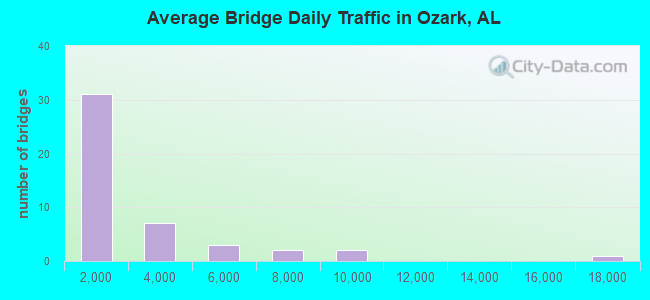
- 107,046Total average daily traffic
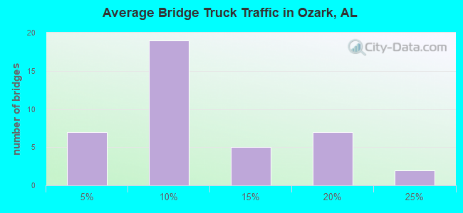
- 12,058Total average daily truck traffic
- 149,588Total future (year 2033) average daily traffic
- National Bridge Inventory (NBI) Registered Bridges for Ozark
- No street view available for this location
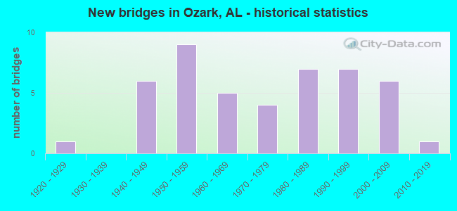
- New bridges - historical statistics
- 11920-1929
- 61940-1949
- 91950-1959
- 51960-1969
- 41970-1979
- 71980-1989
- 71990-1999
- 62000-2009
- 12010-2019
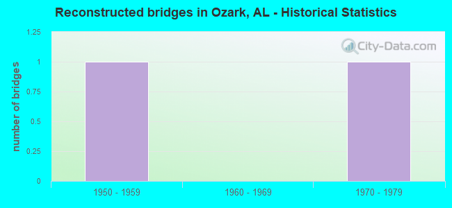
- Reconstructed bridges - Historical Statistics
- 11950-1959
- 01960-1969
- 11970-1979
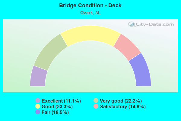
- Bridge Condition - Deck
- 11.1%Excellent
- 22.2%Very good
- 33.3%Good
- 14.8%Satisfactory
- 18.5%Fair
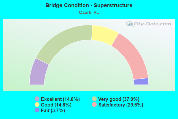
- Bridge Condition - Superstructure
- 14.8%Excellent
- 37.0%Very good
- 14.8%Good
- 29.6%Satisfactory
- 3.7%Fair
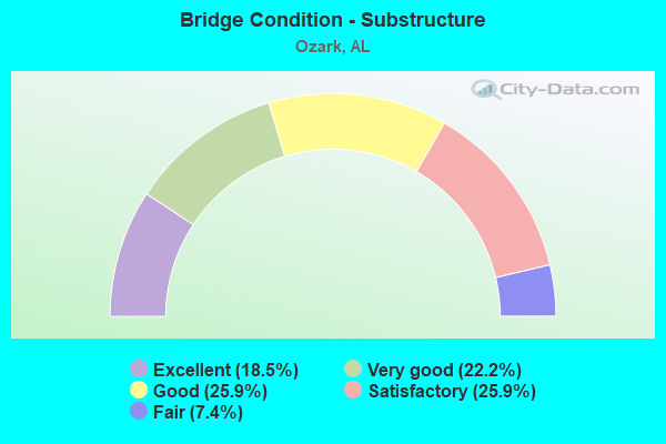
- Bridge Condition - Substructure
- 18.5%Excellent
- 22.2%Very good
- 25.9%Good
- 25.9%Satisfactory
- 7.4%Fair
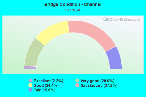
- Bridge Condition - Channel
- 2.2%Excellent
- 20.0%Very good
- 24.4%Good
- 37.8%Satisfactory
- 15.6%Fair
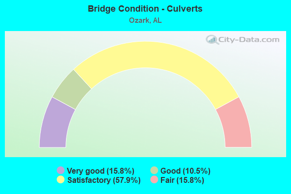
- Bridge Condition - Culverts
- 15.8%Very good
- 10.5%Good
- 57.9%Satisfactory
- 15.8%Fair
Find on map >> Show street view
Structure Number: 19008, Location: SEC 15 T-6N R-23-E (Lat: 31.493011, Lng: -85.728775), Route carried "on" structure: Spur County highway 36, Year Built: 2002, Status: Open, Structure Length: 5.18m (16.99ft), Average Daily Traffic: 771 (year 2003), Truck Traffic: 15%, Average Future Daily Traffic: 1,146 (year 2034), Design Load: HS 20, Features Intersected: CLAY BANK CREEK
Minimum Vertical Clearance: 30+ m (98+ ft), Kilometerpoint: 0.000, Lanes on structure: 2, Owner: County Highway Agency, Approaching Roadway Width: 6.7m (22.0ft), Material/Design: Concrete, Design/Construction: Channel Beam, Number Of Spans In Main Unit: 5, Length of Maximum Span: 10.4m (34.1ft), Curb-To-Curb Width: 8.5m (27.9ft), Out-to-Out Width: 9.8m (32.2ft)
Condition: Deck: Excellent, Superstructure: Excellent, Substructure: Excellent, Channel: Excellent, Operating Rating: 79.0 metric tons, Method Used To Determine Operating Rating: Load Factor (LF), Inventory Rating: 47.4 metric tons, Method Used To Determine Inventory Rating: Load Factor (LF), Structural Evaluation: Superior to present desirable criteria, Deck Geometry: Somewhat better than minimum adequacy, Waterway Adequacy: Equal to present minimum criteria, Approach Roadway Alignment: Equal to present desirable criteria, Length Of Structure Improvement: 6.21m (20.37ft), Designated Inspection Frequency: Every 24 months, Inspection Date: September 2020, Bridge Improvement Cost: $1,362,000, Roadway Improvement Cost: $136,000, Total Project Cost: $1,498,000 ( Estimate for 2022), Deck Structure Type: Concrete Precast Panels
Find on map >> Show street view
Structure Number: 19504, Location: SEC. 5 T-4-N,R-23-E (Lat: 31.436111, Lng: -85.653056), Route carried "on" structure: Business City street , Year Built: 1995, Status: Open, Structure Length: 0.73m (2.40ft), Average Daily Traffic: 1,500 (year 2012), Truck Traffic: 10%, Average Future Daily Traffic: 2,200 (year 2034), Features Intersected: UNNAMED CREEK, Facility Carried by Structure: DEESE ROAD
Minimum Vertical Clearance: 30+ m (98+ ft), Kilometerpoint: 0.000, Lanes on structure: 2, Owner: City or Municipal Highway Agency, Approaching Roadway Width: 7.3m (24.0ft), Material/Design: Concrete, Design/Construction: Channel Beam, Number Of Spans In Main Unit: 1, Length of Maximum Span: 7.3m (24.0ft), Curb or Sidewalk Widths: Left: 0.0m, Right: 0.9m (3.0ft), Curb-To-Curb Width: 10.7m (35.1ft), Out-to-Out Width: 11.6m (38.1ft)
Condition: Deck: Fair, Superstructure: Satisfactory, Substructure: Good, Channel: Good, Operating Rating: 69.0 metric tons, Method Used To Determine Operating Rating: Load Factor (LF), Inventory Rating: 41.4 metric tons, Method Used To Determine Inventory Rating: Load Factor (LF), Structural Evaluation: Equal to present minimum criteria, Deck Geometry: Equal to present minimum criteria, Waterway Adequacy: Better than present minimum criteria, Approach Roadway Alignment: Equal to present minimum criteria, Length Of Structure Improvement: 1.38m (4.53ft), Designated Inspection Frequency: Every 24 months, Inspection Date: December 2020, Bridge Improvement Cost: $349,000, Roadway Improvement Cost: $35,000, Total Project Cost: $384,000 ( Estimate for 2022), Deck Structure Type: Concrete Precast Panels
Find on map >> Show street view
Structure Number: 19894, Location: SEC.1 T-6-N R-23-E (Lat: 31.517106, Lng: -85.695800), Route carried "on" structure: County highway 108, Year Built: 2007, Status: Open, Structure Length: 1.98m (6.50ft), Average Daily Traffic: 145 (year 2000), Truck Traffic: 5%, Average Future Daily Traffic: 215 (year 2034), Design Load: HS 20, Features Intersected: BEAR CREEK
Minimum Vertical Clearance: 0.00m, Kilometerpoint: 0.000, Lanes on structure: 2, Owner: County Highway Agency, Approaching Roadway Width: 12.2m (40.0ft), Material/Design: Concrete, Design/Construction: Culvert, Number Of Spans In Main Unit: 6, Length of Maximum Span: 3.0m (9.8ft), Out-to-Out Width: 27.4m (89.9ft)
Condition: Channel: Good, Culverts: Good, Operating Rating: 88.9 metric tons, Method Used To Determine Operating Rating: Load Factor (LF), Inventory Rating: 88.9 metric tons, Method Used To Determine Inventory Rating: Load Factor (LF), Structural Evaluation: Better than present minimum criteria, Waterway Adequacy: Equal to present minimum criteria, Approach Roadway Alignment: Equal to present desirable criteria, Length Of Structure Improvement: 2.73m (8.96ft), Designated Inspection Frequency: Every 24 months, Inspection Date: March 2021, Bridge Improvement Cost: $1,417,000, Roadway Improvement Cost: $142,000, Total Project Cost: $1,559,000 ( Estimate for 2022)
Find on map >> Show street view
Structure Number: 20196, Location: 1.49 MI. E OF JCT ALA 105 (Lat: 31.459300, Lng: -85.584100), Route carried "on" structure: County highway 36, Year Built: 1952, Status: Open, Structure Length: 0.85m (2.79ft), Average Daily Traffic: 3,626 (year 2006), Truck Traffic: 6%, Average Future Daily Traffic: 5,077 (year 2034), Design Load: H 15, Features Intersected: JOHNSON'S CREEK
Minimum Vertical Clearance: 30+ m (98+ ft), Kilometerpoint: 0.000, Lanes on structure: 2, Owner: County Highway Agency, Approaching Roadway Width: 8.5m (27.9ft), Skew: 4 degrees, Material/Design: Steel, Design/Construction: Culvert, Number Of Spans In Main Unit: 4, Length of Maximum Span: 2.5m (8.2ft)
Condition: Channel: Good, Culverts: Fair, Operating Rating: 88.9 metric tons, Method Used To Determine Operating Rating: Load Factor (LF), Inventory Rating: 88.9 metric tons, Method Used To Determine Inventory Rating: Load Factor (LF), Structural Evaluation: Somewhat better than minimum adequacy, Waterway Adequacy: Equal to present minimum criteria, Approach Roadway Alignment: Equal to present minimum criteria, Length Of Structure Improvement: 1.51m (4.95ft), Designated Inspection Frequency: Every 24 months, Inspection Date: November 2020, Bridge Improvement Cost: $505,000, Roadway Improvement Cost: $51,000, Total Project Cost: $556,000 ( Estimate for 2022)
Find on map >> Show street view
Structure Number: 20752, Location: INT JODIE PARKER ROAD (Lat: 31.473333, Lng: -85.661667), Route carried "on" structure: County highway 36, Year Built: 2014, Status: Open, Structure Length: 3.22m (10.56ft), Average Daily Traffic: 3,626 (year 2010), Truck Traffic: 9%, Average Future Daily Traffic: 5,760 (year 2035), Design Load: HS 20, Features Intersected: LITTLE CLAYBANK CREEK, Facility Carried by Structure: ROY PARKER ROAD
Minimum Vertical Clearance: 30+ m (98+ ft), Kilometerpoint: 0.000, Lanes on structure: 2, Owner: City or Municipal Highway Agency, Approaching Roadway Width: 9.1m (29.9ft), Skew: 1 degrees, Material/Design: Prestressed concrete, Design/Construction: Stringer/Multi-beam, Number Of Spans In Main Unit: 3, Length of Maximum Span: 10.9m (35.8ft), Curb-To-Curb Width: 10.4m (34.1ft), Out-to-Out Width: 11.2m (36.7ft)
Condition: Deck: Very good, Superstructure: Very good, Substructure: Excellent, Channel: Very good, Operating Rating: 88.9 metric tons, Method Used To Determine Operating Rating: Load Factor (LF), Inventory Rating: 68.1 metric tons, Method Used To Determine Inventory Rating: Load Factor (LF), Structural Evaluation: Equal to present desirable criteria, Deck Geometry: Somewhat better than minimum adequacy, Waterway Adequacy: Equal to present desirable criteria, Approach Roadway Alignment: Equal to present desirable criteria, Length Of Structure Improvement: 4.09m (13.42ft), Designated Inspection Frequency: Every 24 months, Inspection Date: December 2020, Bridge Improvement Cost: $1,011,000, Roadway Improvement Cost: $101,000, Total Project Cost: $1,112,000 ( Estimate for 2022), Deck Structure Type: Concrete Cast-file-Place