Bridge Statistics for Palm Coast, Florida (FL)
Condition, Traffic, Stress, Structural Evaluation, Project Costs
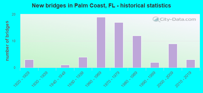
- New bridges - historical statistics
- 31920-1929
- 11940-1949
- 41950-1959
- 191960-1969
- 171970-1979
- 121980-1989
- 21990-1999
- 92000-2009
- 32010-2019
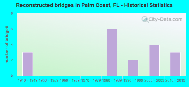
- Reconstructed bridges - Historical Statistics
- 31940-1949
- 01950-1959
- 01960-1969
- 01970-1979
- 61980-1989
- 21990-1999
- 42000-2009
- 32010-2019
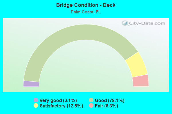
- Bridge Condition - Deck
- 3.1%Very good
- 78.1%Good
- 12.5%Satisfactory
- 6.3%Fair
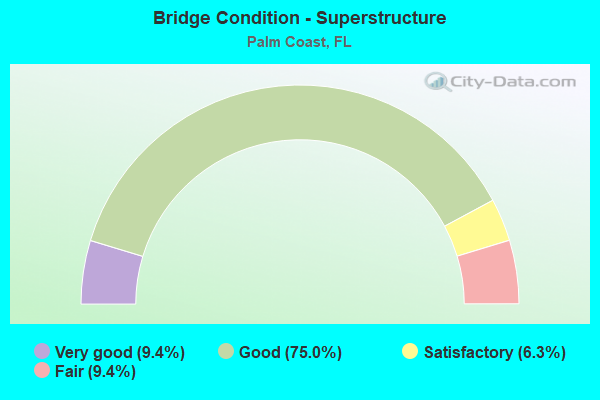
- Bridge Condition - Superstructure
- 9.4%Very good
- 75.0%Good
- 6.3%Satisfactory
- 9.4%Fair
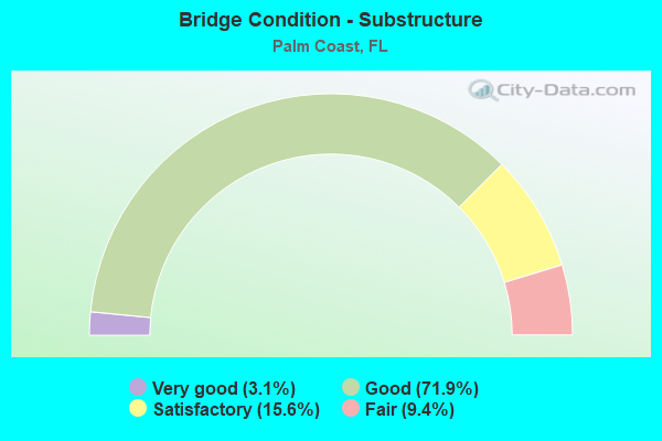
- Bridge Condition - Substructure
- 3.1%Very good
- 71.9%Good
- 15.6%Satisfactory
- 9.4%Fair
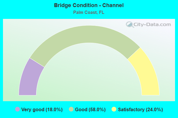
- Bridge Condition - Channel
- 18.0%Very good
- 58.0%Good
- 24.0%Satisfactory
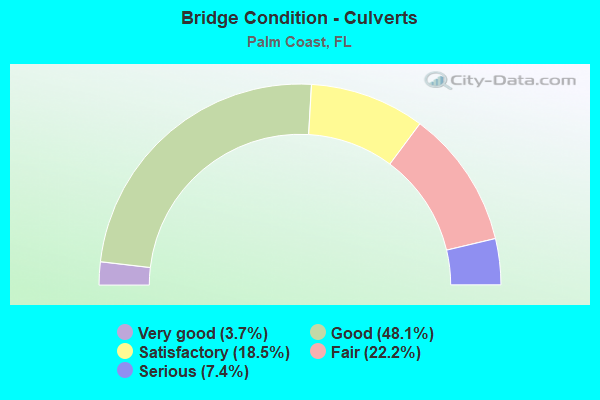
- Bridge Condition - Culverts
- 3.7%Very good
- 48.1%Good
- 18.5%Satisfactory
- 22.2%Fair
- 7.4%Serious
Find on map >> Show street view
Structure Number: 730006, Location: US-1 SB over St Joe Canal (Lat: 29.555250, Lng: -81.266328), Route carried "on" structure: US 5, Year Built: 1928, Year Reconstructed: 1948, Status: Open, Structure Length: 2.25m (7.38ft), Average Daily Traffic: 5,900 (year 2020), Truck Traffic: 9%, Average Future Daily Traffic: 10,236 (year 2042), Design Load: H 20, Features Intersected: St. Joe Canal, Facility Carried by Structure: US-1 SB
Minimum Vertical Clearance: 30+ m (98+ ft), Kilometerpoint: 27.069, Lanes on structure: 2, Base Highway Network: Yes, Owner: State Highway Agency, Approaching Roadway Width: 8.8m (28.9ft), Material/Design: Concrete, Design/Construction: Slab, Number Of Spans In Main Unit: 4, Length of Maximum Span: 5.5m (18.0ft), Curb-To-Curb Width: 8.5m (27.9ft), Out-to-Out Width: 10.1m (33.1ft)
Condition: Deck: Good, Superstructure: Good, Substructure: Satisfactory, Channel: Satisfactory, Operating Rating: 55.5 metric tons, Method Used To Determine Operating Rating: Load Testing, Inventory Rating: 32.7 metric tons, Method Used To Determine Inventory Rating: Load Testing, Structural Evaluation: Equal to present minimum criteria, Deck Geometry: High priority of corrective action, Waterway Adequacy: Equal to present desirable criteria, Approach Roadway Alignment: Equal to present desirable criteria, Length Of Structure Improvement: 2.19m (7.19ft), Designated Inspection Frequency: Every 24 months, Underwater Inspection Frequency: Every 24 months, Inspection Date: May 2021, Underwater Inspection Date: May 2021, Bridge Improvement Cost: $265,000, Total Project Cost: $331,000, Deck Structure Type: Concrete Cast-file-Place, Wearing Surface/Protective System: Wearing Surface: Bituminous
Find on map >> Show street view
Structure Number: 730007, Location: US-1 SB - Hulett Branch (Lat: 29.611264, Lng: -81.281103), Route carried "on" structure: US 1, Year Built: 1928, Year Reconstructed: 1948, Status: Open, Structure Length: 2.87m (9.42ft), Average Daily Traffic: 5,900 (year 2020), Truck Traffic: 9%, Average Future Daily Traffic: 10,236 (year 2042), Design Load: H 20, Features Intersected: Hulett Branch
Minimum Vertical Clearance: 30+ m (98+ ft), Kilometerpoint: 33.568, Lanes on structure: 2, Base Highway Network: Yes, Owner: State Highway Agency, Approaching Roadway Width: 8.4m (27.6ft), Material/Design: Concrete, Design/Construction: Slab, Number Of Spans In Main Unit: 4, Length of Maximum Span: 6.3m (20.7ft), Curb-To-Curb Width: 8.5m (27.9ft), Out-to-Out Width: 10.2m (33.5ft)
Condition: Deck: Good, Superstructure: Good, Substructure: Good, Channel: Good, Operating Rating: 55.5 metric tons, Method Used To Determine Operating Rating: Load Testing, Inventory Rating: 32.7 metric tons, Method Used To Determine Inventory Rating: Load Testing, Structural Evaluation: Better than present minimum criteria, Deck Geometry: High priority of corrective action, Waterway Adequacy: Equal to present minimum criteria, Approach Roadway Alignment: Equal to present desirable criteria, Designated Inspection Frequency: Every 24 months, Underwater Inspection Frequency: Every 24 months, Inspection Date: September 2021, Underwater Inspection Date: September 2021, Deck Structure Type: Concrete Cast-file-Place, Wearing Surface/Protective System: Wearing Surface: Bituminous
Find on map >> Show street view
Structure Number: 730008, Location: US-1 SB - Pellicer Creek (Lat: 29.651350, Lng: -81.286867), Route carried "on" structure: US 1, Year Built: 1927, Year Reconstructed: 1948, Status: Open, Structure Length: 6.82m (22.38ft), Average Daily Traffic: 5,900 (year 2020), Truck Traffic: 9%, Average Future Daily Traffic: 10,236 (year 2042), Design Load: H 15, Features Intersected: Pellicer Creek
Minimum Vertical Clearance: 30+ m (98+ ft), Kilometerpoint: 38.030, Lanes on structure: 2, Base Highway Network: Yes, Owner: State Highway Agency, Approaching Roadway Width: 8.5m (27.9ft), Material/Design: Concrete, Design/Construction: Tee Beam, Number Of Spans In Main Unit: 7, Length of Maximum Span: 9.4m (30.8ft), Curb-To-Curb Width: 8.5m (27.9ft), Out-to-Out Width: 10.0m (32.8ft)
Condition: Deck: Satisfactory, Superstructure: Fair, Substructure: Fair, Channel: Good, Operating Rating: 31.9 metric tons, Method Used To Determine Operating Rating: Load and Resistance Factor (LRFR), Inventory Rating: 24.7 metric tons, Method Used To Determine Inventory Rating: Load and Resistance Factor (LRFR), Structural Evaluation: Somewhat better than minimum adequacy, Deck Geometry: High priority of corrective action, Waterway Adequacy: Equal to present desirable criteria, Approach Roadway Alignment: Equal to present desirable criteria, Designated Inspection Frequency: Every 24 months, Underwater Inspection Frequency: Every 24 months, Inspection Date: September 2021, Underwater Inspection Date: October 2021, Deck Structure Type: Concrete Cast-file-Place, Wearing Surface/Protective System: Wearing Surface: Bituminous
Find on map >> Show street view
Structure Number: 730032, Location: 1.0 Mi. N of Volusia Co. (Lat: 29.417222, Lng: -81.160833), Route carried "on" structure: Interstate 95, Year Built: 1964, Year Reconstructed: 1993, Status: Open, Structure Length: 1.18m (3.87ft), Average Daily Traffic: 60,500 (year 2020), Truck Traffic: 8%, Average Future Daily Traffic: 104,968 (year 2042), Design Load: HS 20+Mod, Features Intersected: Korona Canal
Minimum Vertical Clearance: 30+ m (98+ ft), Kilometerpoint: 1.679, Lanes on structure: 6, Base Highway Network: Yes, Owner: State Highway Agency, Approaching Roadway Width: 23.2m (76.1ft), Skew: 14 degrees, Material/Design: Concrete, Design/Construction: Culvert, Number Of Spans In Main Unit: 3, Length of Maximum Span: 3.7m (12.1ft)
Condition: Channel: Satisfactory, Culverts: Satisfactory, Operating Rating: 65.3 metric tons, Method Used To Determine Operating Rating: Load Factor (LF), Inventory Rating: 39.2 metric tons, Method Used To Determine Inventory Rating: Load Factor (LF), Structural Evaluation: Equal to present minimum criteria, Waterway Adequacy: Equal to present desirable criteria, Approach Roadway Alignment: Equal to present desirable criteria, Designated Inspection Frequency: Every 24 months, Inspection Date: December 2020
Find on map >> Show street view
Structure Number: 730035, Location: 5.8 Mi. North of SR-100 (Lat: 29.553508, Lng: -81.218439), Route carried "on" structure: Interstate 95, Year Built: 1965, Year Reconstructed: 1995, Status: Open, Structure Length: 0.79m (2.59ft), Average Daily Traffic: 76,000 (year 2020), Truck Traffic: 8%, Average Future Daily Traffic: 131,860 (year 2042), Design Load: HS 20+Mod, Features Intersected: St. Joe Canal
Minimum Vertical Clearance: 30+ m (98+ ft), Kilometerpoint: 17.823, Lanes on structure: 6, Base Highway Network: Yes, Owner: State Highway Agency, Approaching Roadway Width: 21.9m (71.9ft), Skew: 33 degrees, Material/Design: Concrete, Design/Construction: Culvert, Number Of Spans In Main Unit: 2, Length of Maximum Span: 3.8m (12.5ft)
Condition: Channel: Good, Culverts: Good, Operating Rating: 87.1 metric tons, Method Used To Determine Operating Rating: Load Factor (LF), Inventory Rating: 52.3 metric tons, Method Used To Determine Inventory Rating: Load Factor (LF), Structural Evaluation: Better than present minimum criteria, Waterway Adequacy: Equal to present desirable criteria, Approach Roadway Alignment: Equal to present desirable criteria, Designated Inspection Frequency: Every 24 months, Inspection Date: December 2020
Find on map >> Show street view
Structure Number: 730037, Location: 7.4 MI. N of SR-100 (Lat: 29.573992, Lng: -81.231889), Route carried "on" structure: Interstate 95, Year Built: 1965, Status: Open, Structure Length: 0.97m (3.18ft), Average Daily Traffic: 58,500 (year 2020), Truck Traffic: 8%, Average Future Daily Traffic: 101,498 (year 2042), Design Load: HS 20+Mod, Features Intersected: Big Mulberry Branch
Minimum Vertical Clearance: 30+ m (98+ ft), Kilometerpoint: 20.453, Lanes on structure: 6, Base Highway Network: Yes, Owner: State Highway Agency, Approaching Roadway Width: 29.6m (97.1ft), Skew: 30 degrees, Material/Design: Concrete, Design/Construction: Culvert, Number Of Spans In Main Unit: 3, Length of Maximum Span: 3.2m (10.5ft)
Condition: Channel: Good, Culverts: Good, Operating Rating: 55.9 metric tons, Method Used To Determine Operating Rating: Load Factor (LF), Inventory Rating: 33.5 metric tons, Method Used To Determine Inventory Rating: Load Factor (LF), Structural Evaluation: Better than present minimum criteria, Waterway Adequacy: Equal to present desirable criteria, Approach Roadway Alignment: Equal to present desirable criteria, Designated Inspection Frequency: Every 24 months, Inspection Date: December 2020
Find on map >> Show street view
Structure Number: 730038, Location: Old Kings Rd over I-95 (Lat: 29.637306, Lng: -81.268500), Route carried "on" structure: County highway , Year Built: 1965, Status: Open, Structure Length: 9.75m (31.99ft), Average Daily Traffic: 1,500 (year 2020), Truck Traffic: 3%, Average Future Daily Traffic: 2,602 (year 2042), Design Load: H 20, Features Intersected: I-95, Facility Carried by Structure: Old Kings Road
Minimum Vertical Clearance: 30+ m (98+ ft), Kilometerpoint: 21.710, Lanes on structure: 2, Lanes under structure: 6, Base Highway Network: Yes, Owner: State Highway Agency, Approaching Roadway Width: 10.9m (35.8ft), Skew: 4 degrees, Material/Design: Prestressed concrete, Design/Construction: Stringer/Multi-beam, Number Of Spans In Main Unit: 4, Length of Maximum Span: 32.0m (105.0ft), Curb or Sidewalk Widths: Left: 0.4m (1.3ft), Right: 0.4m (1.3ft), Curb-To-Curb Width: 7.3m (24.0ft), Out-to-Out Width: 8.8m (28.9ft)
Condition: Deck: Good, Superstructure: Satisfactory, Substructure: Good, Operating Rating: 65.3 metric tons, Method Used To Determine Operating Rating: Load Factor (LF), Inventory Rating: 40.2 metric tons, Method Used To Determine Inventory Rating: Load Factor (LF), Structural Evaluation: Equal to present minimum criteria, Deck Geometry: Meets minimum limits, Underclear: Meets minimum limits, Approach Roadway Alignment: Equal to present desirable criteria, Designated Inspection Frequency: Every 24 months, Inspection Date: December 2020, Deck Structure Type: Concrete Cast-file-Place
Find on map >> Show street view
Structure Number: 730043, Location: US-1 NB over St Joe Canal (Lat: 29.555342, Lng: -81.266156), Route carried "on" structure: US 5, Year Built: 1957, Status: Open, Structure Length: 2.50m (8.20ft), Average Daily Traffic: 5,900 (year 2020), Truck Traffic: 9%, Average Future Daily Traffic: 10,236 (year 2042), Design Load: H 20, Features Intersected: St. Joe Canal, Facility Carried by Structure: US-1 NB
Minimum Vertical Clearance: 30+ m (98+ ft), Kilometerpoint: 27.069, Lanes on structure: 2, Base Highway Network: Yes, Owner: State Highway Agency, Approaching Roadway Width: 8.8m (28.9ft), Material/Design: Concrete, Design/Construction: Slab, Number Of Spans In Main Unit: 4, Length of Maximum Span: 6.1m (20.0ft), Curb-To-Curb Width: 8.5m (27.9ft), Out-to-Out Width: 10.3m (33.8ft)
Condition: Deck: Good, Superstructure: Good, Substructure: Satisfactory, Channel: Good, Operating Rating: 49.5 metric tons, Method Used To Determine Operating Rating: Load Testing, Inventory Rating: 29.7 metric tons, Method Used To Determine Inventory Rating: Load Testing, Structural Evaluation: Equal to present minimum criteria, Deck Geometry: High priority of corrective action, Waterway Adequacy: Equal to present desirable criteria, Approach Roadway Alignment: Equal to present desirable criteria, Designated Inspection Frequency: Every 24 months, Underwater Inspection Frequency: Every 24 months, Inspection Date: May 2021, Underwater Inspection Date: May 2021, Deck Structure Type: Concrete Cast-file-Place, Wearing Surface/Protective System: Wearing Surface: Bituminous
Find on map >> Show street view
Structure Number: 730044, Location: US-1 NB - Hulett Branch (Lat: 29.611228, Lng: -81.280906), Route carried "on" structure: US 1, Year Built: 1957, Status: Open, Structure Length: 2.50m (8.20ft), Average Daily Traffic: 5,900 (year 2020), Truck Traffic: 9%, Average Future Daily Traffic: 10,236 (year 2042), Design Load: HS 20, Features Intersected: Hulett Branch
Minimum Vertical Clearance: 30+ m (98+ ft), Kilometerpoint: 33.568, Lanes on structure: 2, Base Highway Network: Yes, Owner: State Highway Agency, Approaching Roadway Width: 8.7m (28.5ft), Material/Design: Concrete, Design/Construction: Slab, Number Of Spans In Main Unit: 4, Length of Maximum Span: 6.1m (20.0ft), Curb-To-Curb Width: 8.5m (27.9ft), Out-to-Out Width: 10.4m (34.1ft)
Condition: Deck: Good, Superstructure: Good, Substructure: Fair, Channel: Very good, Operating Rating: 49.5 metric tons, Method Used To Determine Operating Rating: Load Testing, Inventory Rating: 29.7 metric tons, Method Used To Determine Inventory Rating: Load Testing, Structural Evaluation: Somewhat better than minimum adequacy, Deck Geometry: High priority of corrective action, Waterway Adequacy: Somewhat better than minimum adequacy, Approach Roadway Alignment: Equal to present desirable criteria, Designated Inspection Frequency: Every 24 months, Underwater Inspection Frequency: Every 24 months, Inspection Date: September 2021, Underwater Inspection Date: September 2021, Deck Structure Type: Concrete Cast-file-Place, Wearing Surface/Protective System: Wearing Surface: Bituminous
Find on map >> Show street view
Structure Number: 730045, Location: US-1 NB - Pellicer Creek (Lat: 29.651347, Lng: -81.286669), Route carried "on" structure: US 5, Year Built: 1957, Status: Posted for load, Structure Length: 6.77m (22.21ft), Average Daily Traffic: 5,900 (year 2020), Truck Traffic: 9%, Average Future Daily Traffic: 10,236 (year 2042), Design Load: H 20, Features Intersected: Pellicer Creek, Facility Carried by Structure: US-1 NB
Minimum Vertical Clearance: 30+ m (98+ ft), Kilometerpoint: 38.030, Lanes on structure: 2, Base Highway Network: Yes, Owner: State Highway Agency, Approaching Roadway Width: 8.5m (27.9ft), Material/Design: Concrete, Design/Construction: Slab, Number Of Spans In Main Unit: 11, Length of Maximum Span: 6.1m (20.0ft), Curb-To-Curb Width: 8.5m (27.9ft), Out-to-Out Width: 10.3m (33.8ft)
Condition: Deck: Satisfactory, Superstructure: Satisfactory, Substructure: Fair, Channel: Good, Operating Rating: 22.5 metric tons, Method Used To Determine Operating Rating: Load and Resistance Factor (LRFR), Inventory Rating: 17.3 metric tons, Method Used To Determine Inventory Rating: Load and Resistance Factor (LRFR), Structural Evaluation: Meets minimum limits, Deck Geometry: High priority of corrective action, Waterway Adequacy: Equal to present desirable criteria, Approach Roadway Alignment: Equal to present desirable criteria, Bridge Posting: Required (Relationship of Operating Rating to Maximum Legal Load: 20.0 - 29.9% below), Designated Inspection Frequency: Every 24 months, Underwater Inspection Frequency: Every 24 months, Other Special Inspection Frequency: Every 24 months, Inspection Date: September 2021, Underwater Inspection Date: October 2021, Other Special Inspection Date: Febuary 2022, Deck Structure Type: Concrete Cast-file-Place, Wearing Surface/Protective System: Wearing Surface: Monolithic Concrete
Find on map >> Show street view
Structure Number: 730047, Location: I-95 -Town Center Blvd (Lat: 29.497250, Lng: -81.191889), Route carried "on" structure: Interstate 95, Year Built: 1965, Year Reconstructed: 2008, Status: Open, Structure Length: 5.39m (17.68ft), Average Daily Traffic: 76,000 (year 2020), Truck Traffic: 8%, Average Future Daily Traffic: 131,860 (year 2042), Design Load: HS 20+Mod, Features Intersected: Town Center Blvd.
Minimum Vertical Clearance: 30+ m (98+ ft), Kilometerpoint: 11.024, Lanes on structure: 6, Lanes under structure: 2, Base Highway Network: Yes, Owner: State Highway Agency, Approaching Roadway Width: 40.6m (133.2ft), Skew: 31 degrees, Material/Design: Prestressed concrete, Design/Construction: Stringer/Multi-beam, Number Of Spans In Main Unit: 4, Length of Maximum Span: 15.9m (52.2ft), Curb-To-Curb Width: 39.9m (130.9ft), Out-to-Out Width: 41.5m (136.2ft)
Condition: Deck: Satisfactory, Superstructure: Good, Substructure: Good, Channel: Very good, Operating Rating: 54.5 metric tons, Method Used To Determine Operating Rating: Load Factor (LF), Inventory Rating: 33.5 metric tons, Method Used To Determine Inventory Rating: Load Factor (LF), Structural Evaluation: Better than present minimum criteria, Deck Geometry: Superior to present desirable criteria, Underclear: High priority of corrective action, Waterway Adequacy: Better than present minimum criteria, Approach Roadway Alignment: Equal to present desirable criteria, Designated Inspection Frequency: Every 24 months, Inspection Date: May 2020, Deck Structure Type: Concrete Cast-file-Place
Find on map >> Show street view
Structure Number: 730057, Location: Palm Coast Pkwy WB I-95 (Lat: 29.554028, Lng: -81.218753), Route carried "on" structure: County highway , Year Built: 1981, Year Reconstructed: 2011, Status: Open, Structure Length: 8.72m (28.61ft), Average Daily Traffic: 21,750 (year 2020), Truck Traffic: 4%, Average Future Daily Traffic: 37,736 (year 2042), Design Load: HL 93, Features Intersected: I-95, Facility Carried by Structure: Palm Coast Pkwy WB
Minimum Vertical Clearance: 30+ m (98+ ft), Kilometerpoint: 0.299, Lanes on structure: 3, Lanes under structure: 6, Base Highway Network: Yes, Owner: State Highway Agency, Approaching Roadway Width: 11.8m (38.7ft), Skew: 2 degrees, Material/Design: Prestressed concrete, Design/Construction: Stringer/Multi-beam, Number Of Spans In Main Unit: 4, Length of Maximum Span: 29.2m (95.8ft), Curb or Sidewalk Widths: Left: 2.5m (8.2ft), Right: 0.0m, Curb-To-Curb Width: 14.5m (47.6ft), Out-to-Out Width: 15.0m (49.2ft)
Condition: Deck: Good, Superstructure: Good, Substructure: Good, Operating Rating: 34.9 metric tons, Method Used To Determine Operating Rating: Load and Resistance Factor (LRFR), Inventory Rating: 32.7 metric tons, Method Used To Determine Inventory Rating: Load and Resistance Factor (LRFR), Structural Evaluation: Better than present minimum criteria, Deck Geometry: Somewhat better than minimum adequacy, Underclear: Somewhat better than minimum adequacy, Approach Roadway Alignment: Equal to present desirable criteria, Designated Inspection Frequency: Every 24 months, Inspection Date: December 2020, Deck Structure Type: Concrete Cast-file-Place
Find on map >> Show street view
Structure Number: 73006, Location: Palm Coast Pkwy EB I-95 (Lat: 29.553867, Lng: -81.218675), Route carried "on" structure: County highway , Year Built: 1995, Year Reconstructed: 2011, Status: Open, Structure Length: 8.72m (28.61ft), Average Daily Traffic: 21,750 (year 2020), Truck Traffic: 4%, Average Future Daily Traffic: 37,736 (year 2042), Design Load: HL 93, Features Intersected: I-95, Facility Carried by Structure: Palm Coast Pkwy EB
Minimum Vertical Clearance: 30+ m (98+ ft), Kilometerpoint: 0.299, Lanes on structure: 3, Lanes under structure: 6, Base Highway Network: Yes, Owner: State Highway Agency, Approaching Roadway Width: 11.8m (38.7ft), Skew: 2 degrees, Material/Design: Prestressed concrete, Design/Construction: Stringer/Multi-beam, Number Of Spans In Main Unit: 4, Length of Maximum Span: 29.2m (95.8ft), Curb or Sidewalk Widths: Left: 0.0m, Right: 2.5m (8.2ft), Curb-To-Curb Width: 14.5m (47.6ft), Out-to-Out Width: 20.5m (67.3ft)
Condition: Deck: Good, Superstructure: Very good, Substructure: Good, Operating Rating: 49.4 metric tons, Method Used To Determine Operating Rating: Load and Resistance Factor (LRFR), Inventory Rating: 45.4 metric tons, Method Used To Determine Inventory Rating: Load and Resistance Factor (LRFR), Structural Evaluation: Better than present minimum criteria, Deck Geometry: Somewhat better than minimum adequacy, Underclear: Somewhat better than minimum adequacy, Approach Roadway Alignment: Equal to present desirable criteria, Designated Inspection Frequency: Every 24 months, Inspection Date: December 2020, Deck Structure Type: Concrete Cast-file-Place
Find on map >> Show street view
Structure Number: 730071, Location: 1.0 MILES SOUTH of US-1 (Lat: 29.652522, Lng: -81.276794), Route carried "on" structure: Interstate 95, Year Built: 2007, Status: Open, Structure Length: 5.50m (18.04ft), Average Daily Traffic: 58,500 (year 2020), Truck Traffic: 8%, Average Future Daily Traffic: 101,498 (year 2042), Design Load: HS 20+Mod, Features Intersected: Pellicer Creek
Minimum Vertical Clearance: 30+ m (98+ ft), Kilometerpoint: 30.087, Lanes on structure: 6, Base Highway Network: Yes, Owner: State Highway Agency, Approaching Roadway Width: 29.0m (95.1ft), Skew: 31 degrees, Material/Design: Prestressed concrete, Design/Construction: Stringer/Multi-beam, Number Of Spans In Main Unit: 3, Length of Maximum Span: 18.1m (59.4ft), Curb-To-Curb Width: 39.8m (130.6ft), Out-to-Out Width: 41.2m (135.2ft)
Condition: Deck: Good, Superstructure: Good, Substructure: Good, Channel: Very good, Operating Rating: 37.6 metric tons, Method Used To Determine Operating Rating: Load and Resistance Factor (LRFR), Inventory Rating: 28.8 metric tons, Method Used To Determine Inventory Rating: Load and Resistance Factor (LRFR), Structural Evaluation: Better than present minimum criteria, Deck Geometry: Superior to present desirable criteria, Waterway Adequacy: Equal to present desirable criteria, Approach Roadway Alignment: Equal to present desirable criteria, Designated Inspection Frequency: Every 24 months, Underwater Inspection Frequency: Every 24 months, Inspection Date: July 2021, Underwater Inspection Date: July 2021, Deck Structure Type: Concrete Cast-file-Place
Find on map >> Show street view
Structure Number: 730072, Location: I-95 over SR-100 (Lat: 29.475889, Lng: -81.183750), Route carried "on" structure: Interstate 95, Year Built: 2007, Status: Open, Structure Length: 7.47m (24.51ft), Average Daily Traffic: 76,000 (year 2020), Truck Traffic: 8%, Average Future Daily Traffic: 131,860 (year 2042), Design Load: HL 93, Features Intersected: SR-100
Minimum Vertical Clearance: 30+ m (98+ ft), Kilometerpoint: 8.517, Lanes on structure: 6, Lanes under structure: 6, Base Highway Network: Yes, Owner: State Highway Agency, Approaching Roadway Width: 40.2m (131.9ft), Skew: 31 degrees, Material/Design: Steel, Design/Construction: Stringer/Multi-beam, Number Of Spans In Main Unit: 1, Length of Maximum Span: 74.1m (243.1ft), Curb-To-Curb Width: 39.6m (129.9ft), Out-to-Out Width: 41.2m (135.2ft)
Condition: Deck: Good, Superstructure: Very good, Substructure: Good, Operating Rating: 59.1 metric tons, Method Used To Determine Operating Rating: Load and Resistance Factor (LRFR), Inventory Rating: 45.7 metric tons, Method Used To Determine Inventory Rating: Load and Resistance Factor (LRFR), Structural Evaluation: Better than present minimum criteria, Deck Geometry: Superior to present desirable criteria, Underclear: Superior to present desirable criteria, Approach Roadway Alignment: Equal to present desirable criteria, Designated Inspection Frequency: Every 24 months, Inspection Date: May 2020, Deck Structure Type: Concrete Cast-file-Place
Find on map >> Show street view
Structure Number: 730941, Location: 6.4 Mi N of Volusia Co (Lat: 29.423908, Lng: -81.217497), Route carried "on" structure: US 5, Year Built: 1957, Year Reconstructed: 2002, Status: Open, Structure Length: 0.94m (3.08ft), Average Daily Traffic: 14,100 (year 2020), Truck Traffic: 14%, Average Future Daily Traffic: 24,464 (year 2042), Design Load: HS 15, Features Intersected: Dupont Canal, Facility Carried by Structure: US-1 NB
Minimum Vertical Clearance: 30+ m (98+ ft), Kilometerpoint: 10.421, Lanes on structure: 4, Base Highway Network: Yes, Owner: State Highway Agency, Approaching Roadway Width: 18.3m (60.0ft), Skew: 10 degrees, Material/Design: Concrete, Design/Construction: Culvert, Number Of Spans In Main Unit: 3, Length of Maximum Span: 3.0m (9.8ft)
Condition: Channel: Satisfactory, Culverts: Good, Operating Rating: 35.4 metric tons, Method Used To Determine Operating Rating: Load and Resistance Factor (LRFR), Inventory Rating: 27.3 metric tons, Method Used To Determine Inventory Rating: Load and Resistance Factor (LRFR), Structural Evaluation: Equal to present minimum criteria, Waterway Adequacy: Better than present minimum criteria, Approach Roadway Alignment: Equal to present desirable criteria, Designated Inspection Frequency: Every 24 months, Underwater Inspection Frequency: Every 24 months, Inspection Date: March 2020, Underwater Inspection Date: March 2020
Find on map >> Show street view
Structure Number: 734022, Location: 0.5 mile SW of CR-13 (Lat: 29.504208, Lng: -81.315283), Route carried "on" structure: County highway 205, Year Built: 1965, Year Reconstructed: 2016, Status: Posted for load, Structure Length: 0.63m (2.07ft), Average Daily Traffic: 800 (year 2021), Truck Traffic: 7%, Average Future Daily Traffic: 1,388 (year 2042), Design Load: H 20, Features Intersected: Canal
Minimum Vertical Clearance: 30+ m (98+ ft), Kilometerpoint: 5.335, Lanes on structure: 2, Owner: County Highway Agency, Approaching Roadway Width: 12.2m (40.0ft), Material/Design: Concrete, Design/Construction: Culvert, Number Of Spans In Main Unit: 2, Length of Maximum Span: 3.0m (9.8ft)
Condition: Channel: Satisfactory, Culverts: Satisfactory, Operating Rating: 39.6 metric tons, Method Used To Determine Operating Rating: Allowable Stress (AS), Inventory Rating: 26.6 metric tons, Method Used To Determine Inventory Rating: Allowable Stress (AS), Structural Evaluation: Equal to present minimum criteria, Waterway Adequacy: Better than present minimum criteria, Approach Roadway Alignment: Equal to present desirable criteria, Designated Inspection Frequency: Every 24 months, Inspection Date: December 2021
Find on map >> Show street view
Structure Number: 734027, Location: 1.7 miles S of SR-100 (Lat: 29.454047, Lng: -81.166736), Route carried "on" structure: County highway 2001, Year Built: 1962, Status: Open, Structure Length: 0.69m (2.26ft), Average Daily Traffic: 3,600 (year 2021), Truck Traffic: 7%, Average Future Daily Traffic: 6,246 (year 2042), Design Load: H 20, Features Intersected: Gray Canal, Facility Carried by Structure: Old Kings Road
Minimum Vertical Clearance: 30+ m (98+ ft), Kilometerpoint: 4.508, Lanes on structure: 2, Owner: County Highway Agency, Approaching Roadway Width: 7.6m (24.9ft), Skew: 3 degrees, Material/Design: Concrete, Design/Construction: Culvert, Number Of Spans In Main Unit: 2, Length of Maximum Span: 3.2m (10.5ft)
Condition: Channel: Satisfactory, Culverts: Satisfactory, Operating Rating: 29.8 metric tons, Method Used To Determine Operating Rating: Load Factor (LF), Inventory Rating: 17.9 metric tons, Method Used To Determine Inventory Rating: Load Factor (LF), Structural Evaluation: Meets minimum limits, Waterway Adequacy: Better than present minimum criteria, Approach Roadway Alignment: Equal to present desirable criteria, Designated Inspection Frequency: Every 24 months, Inspection Date: December 2021
Find on map >> Show street view
Structure Number: 734028, Location: 1.8 miles South of SR-100 (Lat: 29.451908, Lng: -81.165342), Route carried "on" structure: County highway 2001, Year Built: 1962, Year Reconstructed: 2016, Status: Open, Structure Length: 0.94m (3.08ft), Average Daily Traffic: 3,600 (year 2021), Truck Traffic: 7%, Average Future Daily Traffic: 6,246 (year 2042), Design Load: H 20, Features Intersected: Bulow Canal, Facility Carried by Structure: Old Kings Road
Minimum Vertical Clearance: 30+ m (98+ ft), Kilometerpoint: 4.236, Lanes on structure: 2, Owner: County Highway Agency, Approaching Roadway Width: 11.0m (36.1ft), Skew: 5 degrees, Material/Design: Concrete, Design/Construction: Culvert, Number Of Spans In Main Unit: 2, Length of Maximum Span: 4.6m (15.1ft)
Condition: Channel: Good, Culverts: Fair, Operating Rating: 41.6 metric tons, Method Used To Determine Operating Rating: Load Factor (LF), Inventory Rating: 24.9 metric tons, Method Used To Determine Inventory Rating: Load Factor (LF), Structural Evaluation: Somewhat better than minimum adequacy, Waterway Adequacy: Better than present minimum criteria, Approach Roadway Alignment: Equal to present desirable criteria, Designated Inspection Frequency: Every 24 months, Inspection Date: December 2021
Find on map >> Show street view
Structure Number: 73406, Location: 0.4 mi W of Palm Harbor (Lat: 29.574319, Lng: -81.200578), Route carried "on" structure: City street , Year Built: 1970, Status: Open, Structure Length: 2.42m (7.94ft), Average Daily Traffic: 2,330 (year 2021), Truck Traffic: 5%, Average Future Daily Traffic: 2,960 (year 2042), Design Load: HS 20, Features Intersected: Country Club Cove, Facility Carried by Structure: Clubhouse Drive
Minimum Vertical Clearance: 30+ m (98+ ft), Kilometerpoint: 0.000, Lanes on structure: 2, Owner: City or Municipal Highway Agency, Approaching Roadway Width: 7.2m (23.6ft), Material/Design: Prestressed concrete, Design/Construction: Stringer/Multi-beam, Number Of Spans In Main Unit: 1, Length of Maximum Span: 24.2m (79.4ft), Curb or Sidewalk Widths: Left: 1.2m (3.9ft), Right: 1.2m (3.9ft), Curb-To-Curb Width: 8.5m (27.9ft), Out-to-Out Width: 11.9m (39.0ft)
Condition: Deck: Good, Superstructure: Good, Substructure: Satisfactory, Channel: Good, Operating Rating: 43.3 metric tons, Method Used To Determine Operating Rating: Allowable Stress (AS), Inventory Rating: 33.1 metric tons, Method Used To Determine Inventory Rating: Allowable Stress (AS), Structural Evaluation: Equal to present minimum criteria, Deck Geometry: Meets minimum limits, Waterway Adequacy: Better than present minimum criteria, Approach Roadway Alignment: Equal to present desirable criteria, Designated Inspection Frequency: Every 24 months, Underwater Inspection Frequency: Every 24 months, Inspection Date: December 2021, Underwater Inspection Date: December 2021, Deck Structure Type: Concrete Precast Panels, Wearing Surface/Protective System: Wearing Surface: Bituminous
Find on map >> Show street view
Structure Number: 734061, Location: 0.1Mi N of Clubhouse Dr. (Lat: 29.577042, Lng: -81.194581), Route carried "on" structure: City street , Year Built: 1975, Status: Open, Structure Length: 5.55m (18.21ft), Average Daily Traffic: 5,000 (year 2021), Truck Traffic: 7%, Average Future Daily Traffic: 8,675 (year 2042), Design Load: HS 20, Features Intersected: Clubhouse Waterway, Facility Carried by Structure: Palm Harbor Parkwy
Minimum Vertical Clearance: 30+ m (98+ ft), Kilometerpoint: 1.376, Lanes on structure: 2, Owner: City or Municipal Highway Agency, Approaching Roadway Width: 7.9m (25.9ft), Navigation Control: Yes ( Vertical Clearance: 5.5m (18.0ft), Horizontal Clearance: 20.4m (66.9ft)), Material/Design: Prestressed concrete, Design/Construction: Stringer/Multi-beam, Number Of Spans In Main Unit: 3, Length of Maximum Span: 22.9m (75.1ft), Curb or Sidewalk Widths: Left: 1.7m (5.6ft), Right: 1.1m (3.6ft), Curb-To-Curb Width: 7.9m (25.9ft), Out-to-Out Width: 11.9m (39.0ft)
Condition: Deck: Good, Superstructure: Good, Substructure: Good, Channel: Good, Operating Rating: 49.0 metric tons, Method Used To Determine Operating Rating: Load Factor (LF), Inventory Rating: 29.4 metric tons, Method Used To Determine Inventory Rating: Load Factor (LF), Structural Evaluation: Better than present minimum criteria, Deck Geometry: High priority of corrective action, Waterway Adequacy: Equal to present desirable criteria, Approach Roadway Alignment: Better than present minimum criteria, Designated Inspection Frequency: Every 24 months, Underwater Inspection Frequency: Every 24 months, Inspection Date: December 2021, Underwater Inspection Date: December 2021, Deck Structure Type: Concrete Precast Panels
Find on map >> Show street view
Structure Number: 734062, Location: 0.1 mi East of FL Park Dr (Lat: 29.582736, Lng: -81.212939), Route carried "on" structure: County highway , Year Built: 1974, Year Reconstructed: 2014, Status: Open, Structure Length: 5.51m (18.08ft), Average Daily Traffic: 5,000 (year 2022), Truck Traffic: 7%, Average Future Daily Traffic: 8,675 (year 2042), Design Load: HS 20, Features Intersected: College Waterway, Facility Carried by Structure: Palm Harbor Pkwy
Minimum Vertical Clearance: 30+ m (98+ ft), Kilometerpoint: 3.848, Lanes on structure: 2, Owner: City or Municipal Highway Agency, Approaching Roadway Width: 8.7m (28.5ft), Navigation Control: Yes ( Vertical Clearance: 4.8m (15.7ft), Horizontal Clearance: 19.3m (63.3ft)), Material/Design: Prestressed concrete, Design/Construction: Stringer/Multi-beam, Number Of Spans In Main Unit: 3, Length of Maximum Span: 22.9m (75.1ft), Curb-To-Curb Width: 8.5m (27.9ft), Out-to-Out Width: 9.9m (32.5ft)
Condition: Deck: Good, Superstructure: Good, Substructure: Satisfactory, Channel: Good, Operating Rating: 54.5 metric tons, Method Used To Determine Operating Rating: Load Factor (LF), Inventory Rating: 32.7 metric tons, Method Used To Determine Inventory Rating: Load Factor (LF), Structural Evaluation: Equal to present minimum criteria, Deck Geometry: Meets minimum limits, Waterway Adequacy: Equal to present desirable criteria, Approach Roadway Alignment: Equal to present desirable criteria, Designated Inspection Frequency: Every 24 months, Underwater Inspection Frequency: Every 24 months, Inspection Date: January 2022, Underwater Inspection Date: January 2022, Deck Structure Type: Concrete Precast Panels, Wearing Surface/Protective System: Wearing Surface: Bituminous
Find on map >> Show street view
Structure Number: 734063, Location: 0.4 Mi E of Palm Hbr Pkwy (Lat: 29.584997, Lng: -81.213925), Route carried "on" structure: City street , Year Built: 1974, Year Reconstructed: 2016, Status: Open, Structure Length: 4.90m (16.08ft), Average Daily Traffic: 128 (year 2022), Truck Traffic: 2%, Average Future Daily Traffic: 223 (year 2042), Features Intersected: College Waterway, Facility Carried by Structure: Colechester Lane
Minimum Vertical Clearance: 30+ m (98+ ft), Kilometerpoint: 0.000, Lanes on structure: 2, Owner: City or Municipal Highway Agency, Approaching Roadway Width: 8.5m (27.9ft), Navigation Control: Yes ( Vertical Clearance: 5.5m (18.0ft), Horizontal Clearance: 9.4m (30.8ft)), Material/Design: Prestressed concrete, Design/Construction: Slab, Number Of Spans In Main Unit: 5, Length of Maximum Span: 12.3m (40.4ft), Curb or Sidewalk Widths: Left: 1.2m (3.9ft), Right: 1.2m (3.9ft), Curb-To-Curb Width: 8.5m (27.9ft), Out-to-Out Width: 11.9m (39.0ft)
Condition: Deck: Good, Superstructure: Good, Substructure: Good, Channel: Good, Operating Rating: 39.6 metric tons, Method Used To Determine Operating Rating: Load and Resistance Factor (LRFR), Inventory Rating: 30.4 metric tons, Method Used To Determine Inventory Rating: Load and Resistance Factor (LRFR), Structural Evaluation: Better than present minimum criteria, Deck Geometry: Equal to present minimum criteria, Waterway Adequacy: Equal to present minimum criteria, Approach Roadway Alignment: Better than present minimum criteria, Designated Inspection Frequency: Every 24 months, Underwater Inspection Frequency: Every 24 months, Inspection Date: January 2022, Underwater Inspection Date: January 2022, Deck Structure Type: Concrete Precast Panels, Wearing Surface/Protective System: Wearing Surface: Bituminous
Find on map >> Show street view
Structure Number: 734064, Location: 0.2 Mi E of Palm Hrbr Pky (Lat: 29.593542, Lng: -81.218089), Route carried "on" structure: City street , Year Built: 1974, Status: Posted for load, Structure Length: 4.90m (16.08ft), Average Daily Traffic: 441 (year 2022), Truck Traffic: 2%, Average Future Daily Traffic: 765 (year 2042), Features Intersected: College Waterway, Facility Carried by Structure: Colorado Drive
Minimum Vertical Clearance: 30+ m (98+ ft), Kilometerpoint: 0.016, Lanes on structure: 2, Owner: City or Municipal Highway Agency, Approaching Roadway Width: 8.5m (27.9ft), Navigation Control: Yes ( Vertical Clearance: 5.1m (16.7ft), Horizontal Clearance: 9.4m (30.8ft)), Material/Design: Prestressed concrete, Design/Construction: Slab, Number Of Spans In Main Unit: 5, Length of Maximum Span: 12.2m (40.0ft), Curb or Sidewalk Widths: Left: 1.2m (3.9ft), Right: 1.2m (3.9ft), Curb-To-Curb Width: 8.5m (27.9ft), Out-to-Out Width: 11.8m (38.7ft)
Condition: Deck: Fair, Superstructure: Fair, Substructure: Good, Channel: Very good, Operating Rating: 39.6 metric tons, Method Used To Determine Operating Rating: Load and Resistance Factor (LRFR), Inventory Rating: 30.4 metric tons, Method Used To Determine Inventory Rating: Load and Resistance Factor (LRFR), Structural Evaluation: Somewhat better than minimum adequacy, Deck Geometry: Somewhat better than minimum adequacy, Waterway Adequacy: Equal to present desirable criteria, Approach Roadway Alignment: Better than present minimum criteria, Designated Inspection Frequency: Every 24 months, Underwater Inspection Frequency: Every 24 months, Inspection Date: January 2022, Underwater Inspection Date: January 2022, Deck Structure Type: Concrete Precast Panels, Wearing Surface/Protective System: Wearing Surface: Bituminous
Find on map >> Show street view
Structure Number: 734065, Location: 1.0 mi N of Pine Lake Pky (Lat: 29.538003, Lng: -81.247400), Route carried "on" structure: City street , Year Built: 1976, Status: Open, Structure Length: 1.22m (4.00ft), Average Daily Traffic: 972 (year 2020), Truck Traffic: 5%, Average Future Daily Traffic: 1,222 (year 2042), Design Load: HS 20, Features Intersected: Wynfield Waterway, Facility Carried by Structure: West Hampton Drive
Minimum Vertical Clearance: 30+ m (98+ ft), Kilometerpoint: 0.016, Lanes on structure: 2, Owner: City or Municipal Highway Agency, Approaching Roadway Width: 8.5m (27.9ft), Material/Design: Prestressed concrete, Design/Construction: Slab, Number Of Spans In Main Unit: 1, Length of Maximum Span: 12.2m (40.0ft), Curb or Sidewalk Widths: Left: 1.8m (5.9ft), Right: 1.8m (5.9ft), Curb-To-Curb Width: 8.5m (27.9ft), Out-to-Out Width: 13.2m (43.3ft)
Condition: Deck: Good, Superstructure: Good, Substructure: Good, Channel: Good, Operating Rating: 60.9 metric tons, Method Used To Determine Operating Rating: Allowable Stress (AS), Inventory Rating: 48.0 metric tons, Method Used To Determine Inventory Rating: Allowable Stress (AS), Structural Evaluation: Better than present minimum criteria, Deck Geometry: Somewhat better than minimum adequacy, Waterway Adequacy: Equal to present desirable criteria, Approach Roadway Alignment: Better than present minimum criteria, Designated Inspection Frequency: Every 24 months, Inspection Date: January 2022, Deck Structure Type: Concrete Precast Panels, Wearing Surface/Protective System: Wearing Surface: Bituminous
Find on map >> Show street view
Structure Number: 734066, Location: 0.6 mi N of Pine Lake Pky (Lat: 29.542464, Lng: -81.245053), Route carried "on" structure: City street , Year Built: 1976, Status: Open, Structure Length: 1.22m (4.00ft), Average Daily Traffic: 934 (year 2020), Truck Traffic: 2%, Average Future Daily Traffic: 1,621 (year 2042), Design Load: HS 20, Features Intersected: Wynfield Waterway, Facility Carried by Structure: Wellington Drive
Minimum Vertical Clearance: 30+ m (98+ ft), Kilometerpoint: 0.016, Lanes on structure: 2, Owner: City or Municipal Highway Agency, Approaching Roadway Width: 7.3m (24.0ft), Material/Design: Prestressed concrete, Design/Construction: Slab, Number Of Spans In Main Unit: 1, Length of Maximum Span: 12.2m (40.0ft), Curb or Sidewalk Widths: Left: 1.2m (3.9ft), Right: 1.2m (3.9ft), Curb-To-Curb Width: 8.6m (28.2ft), Out-to-Out Width: 11.9m (39.0ft)
Condition: Deck: Good, Superstructure: Good, Substructure: Good, Channel: Good, Operating Rating: 58.8 metric tons, Method Used To Determine Operating Rating: Allowable Stress (AS), Inventory Rating: 48.8 metric tons, Method Used To Determine Inventory Rating: Allowable Stress (AS), Structural Evaluation: Better than present minimum criteria, Deck Geometry: Somewhat better than minimum adequacy, Waterway Adequacy: Equal to present desirable criteria, Approach Roadway Alignment: Better than present minimum criteria, Designated Inspection Frequency: Every 24 months, Inspection Date: January 2022, Deck Structure Type: Concrete Precast Panels, Wearing Surface/Protective System: Wearing Surface: Bituminous
Find on map >> Show street view
Structure Number: 734067, Location: 0.1 mi N of Frontier Dr (Lat: 29.583342, Lng: -81.218194), Route carried "on" structure: City street , Year Built: 1978, Status: Open, Structure Length: 3.66m (12.01ft), Average Daily Traffic: 5,300 (year 2022), Truck Traffic: 7%, Average Future Daily Traffic: 9,196 (year 2042), Design Load: HS 20, Features Intersected: Mulberry Creek, Facility Carried by Structure: Palm Harbor Pkwy
Minimum Vertical Clearance: 30+ m (98+ ft), Kilometerpoint: 0.333, Lanes on structure: 2, Owner: City or Municipal Highway Agency, Approaching Roadway Width: 7.8m (25.6ft), Material/Design: Prestressed concrete, Design/Construction: Slab, Number Of Spans In Main Unit: 3, Length of Maximum Span: 12.2m (40.0ft), Curb or Sidewalk Widths: Left: 0.9m (3.0ft), Right: 1.2m (3.9ft), Curb-To-Curb Width: 8.5m (27.9ft), Out-to-Out Width: 12.5m (41.0ft)
Condition: Deck: Fair, Superstructure: Fair, Substructure: Good, Channel: Satisfactory, Operating Rating: 58.8 metric tons, Method Used To Determine Operating Rating: Allowable Stress (AS), Inventory Rating: 48.8 metric tons, Method Used To Determine Inventory Rating: Allowable Stress (AS), Structural Evaluation: Somewhat better than minimum adequacy, Deck Geometry: High priority of replacement, Waterway Adequacy: Equal to present minimum criteria, Approach Roadway Alignment: Equal to present minimum criteria, Designated Inspection Frequency: Every 24 months, Underwater Inspection Frequency: Every 24 months, Inspection Date: January 2022, Underwater Inspection Date: January 2022, Deck Structure Type: Concrete Precast Panels, Wearing Surface/Protective System: Wearing Surface: Bituminous
Find on map >> Show street view
Structure Number: 734068, Location: 1.7 miles East of I-95 (Lat: 29.562450, Lng: -81.191311), Route carried "on" structure: City street , Year Built: 1985, Status: Open, Structure Length: 2.04m (6.69ft), Average Daily Traffic: 21,750 (year 2022), Truck Traffic: 3%, Average Future Daily Traffic: 37,736 (year 2042), Design Load: HS 20, Features Intersected: St. Joe Canal, Facility Carried by Structure: Palm Coast Pkwy EB
Minimum Vertical Clearance: 30+ m (98+ ft), Kilometerpoint: 3.328, Lanes on structure: 2, Owner: City or Municipal Highway Agency, Approaching Roadway Width: 8.1m (26.6ft), Skew: 3 degrees, Material/Design: Prestressed concrete, Design/Construction: Slab, Number Of Spans In Main Unit: 2, Length of Maximum Span: 10.2m (33.5ft), Curb-To-Curb Width: 12.6m (41.3ft), Out-to-Out Width: 13.5m (44.3ft)
Condition: Deck: Good, Superstructure: Good, Substructure: Good, Channel: Good, Operating Rating: 45.2 metric tons, Method Used To Determine Operating Rating: Allowable Stress (AS), Inventory Rating: 36.0 metric tons, Method Used To Determine Inventory Rating: Allowable Stress (AS), Structural Evaluation: Better than present minimum criteria, Deck Geometry: Better than present minimum criteria, Waterway Adequacy: Equal to present desirable criteria, Approach Roadway Alignment: Equal to present desirable criteria, Designated Inspection Frequency: Every 24 months, Underwater Inspection Frequency: Every 24 months, Inspection Date: January 2022, Underwater Inspection Date: January 2022, Deck Structure Type: Concrete Precast Panels, Wearing Surface/Protective System: Wearing Surface: Bituminous
Find on map >> Show street view
Structure Number: 734071, Location: 2.7 Miles E of I-95 (Lat: 29.573686, Lng: -81.189111), Route carried "on" structure: City street , Year Built: 1988, Status: Open, Structure Length: 79.19m (259.81ft), Average Daily Traffic: 8,600 (year 2020), Truck Traffic: 6%, Average Future Daily Traffic: 14,921 (year 2042), Design Load: HS 20, Features Intersected: Intracoastal Waterway, Facility Carried by Structure: Palm Coast Parkway
Minimum Vertical Clearance: 30+ m (98+ ft), Kilometerpoint: 4.340, Lanes on structure: 2, Lanes under structure: 6, Base Highway Network: Yes, Toll: Toll bridge, Owner: Private, Approaching Roadway Width: 8.8m (28.9ft), Skew: 9 degrees, Navigation Control: Yes ( Vertical Clearance: 19.8m (65.0ft), Horizontal Clearance: 27.4m (89.9ft)), Material/Design: Prestressed concrete, Design/Construction: Stringer/Multi-beam, Number Of Spans In Main Unit: 27, Length of Maximum Span: 39.6m (129.9ft), Curb or Sidewalk Widths: Left: 0.0m, Right: 1.5m (4.9ft), Curb-To-Curb Width: 13.4m (44.0ft), Out-to-Out Width: 16.0m (52.5ft)
Condition: Deck: Good, Superstructure: Good, Substructure: Satisfactory, Channel: Good, Operating Rating: 35.7 metric tons, Method Used To Determine Operating Rating: Load Factor (LF), Inventory Rating: 30.8 metric tons, Method Used To Determine Inventory Rating: Load Factor (LF), Structural Evaluation: Equal to present minimum criteria, Deck Geometry: Equal to present minimum criteria, Underclear: Meets minimum limits, Waterway Adequacy: Superior to present desirable criteria, Approach Roadway Alignment: Equal to present minimum criteria, Designated Inspection Frequency: Every 24 months, Underwater Inspection Frequency: Every 24 months, Inspection Date: May 2021, Underwater Inspection Date: May 2021, Deck Structure Type: Concrete Cast-file-Place, Wearing Surface/Protective System: Wearing Surface: Epoxy Overlay
Find on map >> Show street view
Structure Number: 734073, Location: 1.6 Mi North of SR-100 (Lat: 29.497614, Lng: -81.189839), Route carried "on" structure: City street , Year Built: 1982, Status: Open, Structure Length: 2.56m (8.40ft), Average Daily Traffic: 6,900 (year 2022), Truck Traffic: 7%, Average Future Daily Traffic: 11,972 (year 2042), Design Load: HS 20, Features Intersected: Royal Palms Waterway, Facility Carried by Structure: Old Kings Road
Minimum Vertical Clearance: 30+ m (98+ ft), Kilometerpoint: 2.702, Lanes on structure: 2, Owner: City or Municipal Highway Agency, Approaching Roadway Width: 7.8m (25.6ft), Material/Design: Prestressed concrete, Design/Construction: Slab, Number Of Spans In Main Unit: 2, Length of Maximum Span: 12.8m (42.0ft), Curb-To-Curb Width: 11.6m (38.1ft), Out-to-Out Width: 12.5m (41.0ft)
Condition: Deck: Good, Superstructure: Good, Substructure: Good, Channel: Very good, Operating Rating: 51.8 metric tons, Method Used To Determine Operating Rating: Load Factor (LF), Inventory Rating: 31.1 metric tons, Method Used To Determine Inventory Rating: Load Factor (LF), Structural Evaluation: Better than present minimum criteria, Deck Geometry: Somewhat better than minimum adequacy, Waterway Adequacy: Superior to present desirable criteria, Approach Roadway Alignment: Better than present minimum criteria, Designated Inspection Frequency: Every 24 months, Underwater Inspection Frequency: Every 24 months, Inspection Date: January 2022, Underwater Inspection Date: January 2022, Deck Structure Type: Concrete Precast Panels, Wearing Surface/Protective System: Wearing Surface: Bituminous
Find on map >> Show street view
Structure Number: 734076, Location: 1.5 mi North of SR-100 (Lat: 29.497231, Lng: -81.219761), Route carried "on" structure: County highway , Year Built: 1980, Status: Open, Structure Length: 1.07m (3.51ft), Average Daily Traffic: 21,500 (year 2022), Truck Traffic: 2%, Average Future Daily Traffic: 37,303 (year 2042), Features Intersected: Royal Palms Waterway, Facility Carried by Structure: Belle Terre Parkwy
Minimum Vertical Clearance: 30+ m (98+ ft), Kilometerpoint: 2.462, Lanes on structure: 5, Owner: City or Municipal Highway Agency, Approaching Roadway Width: 14.6m (47.9ft), Skew: 10 degrees, Material/Design: Aluminum, Iron, Design/Construction: Culvert, Number Of Spans In Main Unit: 2, Length of Maximum Span: 4.6m (15.1ft), Curb or Sidewalk Widths: Left: 2.1m (6.9ft), Right: 0.0m
Condition: Channel: Good, Culverts: Good, Structural Evaluation: Better than present minimum criteria, Waterway Adequacy: Better than present minimum criteria, Approach Roadway Alignment: Equal to present desirable criteria, Designated Inspection Frequency: Every 24 months, Underwater Inspection Frequency: Every 24 months, Inspection Date: January 2022, Underwater Inspection Date: January 2022
Find on map >> Show street view
Structure Number: 734077, Location: 3.8 mi North of SR-100 (Lat: 29.528219, Lng: -81.225492), Route carried "on" structure: County highway , Year Built: 1980, Status: Open, Structure Length: 0.82m (2.69ft), Average Daily Traffic: 21,500 (year 2022), Truck Traffic: 2%, Average Future Daily Traffic: 37,303 (year 2042), Features Intersected: Walker Waterway, Facility Carried by Structure: Belle Terre Parkwy
Minimum Vertical Clearance: 30+ m (98+ ft), Kilometerpoint: 5.987, Lanes on structure: 4, Owner: City or Municipal Highway Agency, Approaching Roadway Width: 14.8m (48.6ft), Skew: 10 degrees, Material/Design: Steel, Design/Construction: Culvert, Number Of Spans In Main Unit: 3, Length of Maximum Span: 2.1m (6.9ft), Curb or Sidewalk Widths: Left: 1.8m (5.9ft), Right: 0.0m
Condition: Channel: Good, Culverts: Fair, Structural Evaluation: Somewhat better than minimum adequacy, Waterway Adequacy: Better than present minimum criteria, Approach Roadway Alignment: Equal to present desirable criteria, Designated Inspection Frequency: Every 24 months, Underwater Inspection Frequency: Every 24 months, Inspection Date: January 2022, Underwater Inspection Date: January 2022
Find on map >> Show street view
Structure Number: 734079, Location: 0.3 Mi N of Plm Cst Pkwy (Lat: 29.559833, Lng: -81.197472), Route carried "on" structure: City street , Year Built: 1983, Status: Posted for load, Structure Length: 1.52m (4.99ft), Average Daily Traffic: 3,700 (year 2022), Truck Traffic: 7%, Average Future Daily Traffic: 6,420 (year 2042), Design Load: HS 20, Features Intersected: St. Joe Canal, Facility Carried by Structure: Colbert Lane
Minimum Vertical Clearance: 30+ m (98+ ft), Kilometerpoint: 10.871, Lanes on structure: 2, Owner: City or Municipal Highway Agency, Approaching Roadway Width: 7.5m (24.6ft), Skew: 2 degrees, Material/Design: Prestressed concrete, Design/Construction: Slab, Number Of Spans In Main Unit: 1, Length of Maximum Span: 15.2m (49.9ft), Curb or Sidewalk Widths: Left: 0.0m, Right: 2.6m (8.5ft), Curb-To-Curb Width: 8.1m (26.6ft), Out-to-Out Width: 12.5m (41.0ft)
Condition: Deck: Good, Superstructure: Good, Substructure: Good, Channel: Good, Operating Rating: 19.3 metric tons, Method Used To Determine Operating Rating: Load Factor (LF), Inventory Rating: 11.5 metric tons, Method Used To Determine Inventory Rating: Load Factor (LF), Structural Evaluation: High priority of corrective action, Deck Geometry: High priority of corrective action, Waterway Adequacy: Equal to present desirable criteria, Approach Roadway Alignment: Better than present minimum criteria, Bridge Posting: Required (Relationship of Operating Rating to Maximum Legal Load: > 39.9% below), Designated Inspection Frequency: Every 24 months, Other Special Inspection Frequency: Every 12 months, Inspection Date: January 2022, Other Special Inspection Date: January 2022, Deck Structure Type: Concrete Precast Panels, Wearing Surface/Protective System: Wearing Surface: Bituminous
Find on map >> Show street view
Structure Number: 734088, Location: 1.3 Mi S of I-95 (Lat: 29.627133, Lng: -81.251761), Route carried "on" structure: County highway , Year Built: 2007, Status: Open, Structure Length: 1.81m (5.94ft), Average Daily Traffic: 1,500 (year 2021), Truck Traffic: 1%, Average Future Daily Traffic: 3,150 (year 2042), Design Load: HL 93, Features Intersected: Hominy Branch, Facility Carried by Structure: Old Kings Road
Minimum Vertical Clearance: 30+ m (98+ ft), Kilometerpoint: 19.718, Lanes on structure: 2, Base Highway Network: Yes, Owner: County Highway Agency, Approaching Roadway Width: 8.7m (28.5ft), Material/Design: Concrete, Design/Construction: Culvert, Number Of Spans In Main Unit: 2, Length of Maximum Span: 8.5m (27.9ft)
Condition: Channel: Good, Culverts: Good, Inventory Rating: 75.3 metric tons, Method Used To Determine Inventory Rating: Load and Resistance Factor (LRFR), Structural Evaluation: Better than present minimum criteria, Waterway Adequacy: Better than present minimum criteria, Approach Roadway Alignment: Equal to present desirable criteria, Designated Inspection Frequency: Every 24 months, Inspection Date: March 2021
Find on map >> Show street view
Structure Number: 7355, Location: 0.5 Mi. North of SR-100 (Lat: 29.483619, Lng: -81.196100), Route carried "on" structure: County highway , Year Built: 2007, Status: Open, Structure Length: 1.03m (3.38ft), Average Daily Traffic: 5,000 (year 2020), Truck Traffic: 15%, Average Future Daily Traffic: 8,675 (year 2042), Design Load: HL 93, Features Intersected: Canal, Facility Carried by Structure: Town Center Blvd.
Minimum Vertical Clearance: 30+ m (98+ ft), Kilometerpoint: 8.866, Lanes on structure: 4, Owner: City or Municipal Highway Agency, Approaching Roadway Width: 14.6m (47.9ft), Skew: 21 degrees, Material/Design: Concrete, Design/Construction: Culvert, Number Of Spans In Main Unit: 3, Length of Maximum Span: 3.2m (10.5ft)
Condition: Channel: Good, Culverts: Good, Operating Rating: 79.1 metric tons, Method Used To Determine Operating Rating: Load and Resistance Factor (LRFR), Inventory Rating: 61.0 metric tons, Method Used To Determine Inventory Rating: Load and Resistance Factor (LRFR), Structural Evaluation: Better than present minimum criteria, Waterway Adequacy: Equal to present minimum criteria, Approach Roadway Alignment: Equal to present desirable criteria, Designated Inspection Frequency: Every 24 months, Inspection Date: April 2020
Find on map >> Show street view
Structure Number: 735501, Location: Intersect Palm Coast Pky (Lat: 29.552586, Lng: -81.256242), Route carried "on" structure: City street , Year Built: 2008, Status: Open, Structure Length: 1.17m (3.84ft), Average Daily Traffic: 12,400 (year 2020), Truck Traffic: 5%, Average Future Daily Traffic: 21,514 (year 2042), Design Load: HL 93, Features Intersected: Perennial Canal, Facility Carried by Structure: Pine Lakes Parkway
Minimum Vertical Clearance: 30+ m (98+ ft), Kilometerpoint: 6.083, Lanes on structure: 5, Owner: City or Municipal Highway Agency, Approaching Roadway Width: 21.3m (69.9ft), Material/Design: Concrete, Design/Construction: Culvert, Number Of Spans In Main Unit: 3, Length of Maximum Span: 3.8m (12.5ft), Curb or Sidewalk Widths: Left: 1.8m (5.9ft), Right: 0.0m
Condition: Channel: Very good, Culverts: Good, Inventory Rating: 77.8 metric tons, Method Used To Determine Inventory Rating: Load and Resistance Factor (LRFR), Structural Evaluation: Better than present minimum criteria, Waterway Adequacy: Equal to present minimum criteria, Approach Roadway Alignment: Equal to present desirable criteria, Designated Inspection Frequency: Every 24 months, Underwater Inspection Frequency: Every 24 months, Inspection Date: April 2020, Underwater Inspection Date: April 2020
Find on map >> Show street view
Structure Number: 735502, Location: 0.6 Mi. E of Belle Terre (Lat: 29.599431, Lng: -81.255917), Route carried "on" structure: County highway , Year Built: 1980, Status: Open, Structure Length: 1.49m (4.89ft), Average Daily Traffic: 7,200 (year 2020), Truck Traffic: 7%, Average Future Daily Traffic: 12,492 (year 2042), Features Intersected: Bellaire Waterway, Facility Carried by Structure: Matanzas Woods Pky
Minimum Vertical Clearance: 30+ m (98+ ft), Kilometerpoint: 2.644, Lanes on structure: 2, Base Highway Network: Yes, Owner: City or Municipal Highway Agency, Approaching Roadway Width: 7.3m (24.0ft), Material/Design: Prestressed concrete, Design/Construction: Slab, Number Of Spans In Main Unit: 1, Length of Maximum Span: 14.9m (48.9ft), Curb-To-Curb Width: 11.1m (36.4ft), Out-to-Out Width: 13.6m (44.6ft)
Condition: Deck: Good, Superstructure: Good, Substructure: Good, Channel: Good, Operating Rating: 62.1 metric tons, Method Used To Determine Operating Rating: Load Factor (LF), Inventory Rating: 37.2 metric tons, Method Used To Determine Inventory Rating: Load Factor (LF), Structural Evaluation: Better than present minimum criteria, Deck Geometry: Meets minimum limits, Waterway Adequacy: Equal to present minimum criteria, Approach Roadway Alignment: Equal to present desirable criteria, Designated Inspection Frequency: Every 24 months, Inspection Date: June 2021, Deck Structure Type: Concrete Precast Panels, Wearing Surface/Protective System: Wearing Surface: Bituminous
Find on map >> Show street view
Structure Number: 735503, Location: 0.1Mi SW of Selma Trail (Lat: 29.418306, Lng: -81.169692), Route carried "on" structure: City street , Year Built: 1970, Status: Open, Structure Length: 1.22m (4.00ft), Average Daily Traffic: 500 (year 2021), Truck Traffic: 1%, Average Future Daily Traffic: 625 (year 2042), Features Intersected: Seminole Waterway, Facility Carried by Structure: Secretary Trail
Minimum Vertical Clearance: 30+ m (98+ ft), Kilometerpoint: 0.000, Lanes on structure: 2, Owner: City or Municipal Highway Agency, Approaching Roadway Width: 7.3m (24.0ft), Material/Design: Prestressed concrete, Design/Construction: Slab, Number Of Spans In Main Unit: 1, Length of Maximum Span: 12.2m (40.0ft), Curb or Sidewalk Widths: Left: 0.9m (3.0ft), Right: 1.2m (3.9ft), Curb-To-Curb Width: 7.3m (24.0ft), Out-to-Out Width: 10.7m (35.1ft)
Condition: Deck: Good, Superstructure: Good, Substructure: Good, Channel: Satisfactory, Operating Rating: 69.8 metric tons, Method Used To Determine Operating Rating: Load Factor (LF), Inventory Rating: 41.8 metric tons, Method Used To Determine Inventory Rating: Load Factor (LF), Structural Evaluation: Better than present minimum criteria, Deck Geometry: Meets minimum limits, Waterway Adequacy: Equal to present minimum criteria, Approach Roadway Alignment: Better than present minimum criteria, Designated Inspection Frequency: Every 24 months, Inspection Date: December 2021, Deck Structure Type: Concrete Precast Panels, Wearing Surface/Protective System: Wearing Surface: Bituminous
Find on map >> Show street view
Structure Number: 735505, Location: 1.1 Mi E of Bel Ter Pkwy (Lat: 29.497867, Lng: -81.201047), Route carried "on" structure: City street , Year Built: 2007, Status: Open, Structure Length: 4.88m (16.01ft), Average Daily Traffic: 7,700 (year 2021), Truck Traffic: 7%, Average Future Daily Traffic: 1,360 (year 2042), Design Load: HL 93, Features Intersected: Bellaire Canal, Facility Carried by Structure: Royal Palms Pkwy
Minimum Vertical Clearance: 30+ m (98+ ft), Kilometerpoint: 1.790, Lanes on structure: 2, Owner: City or Municipal Highway Agency, Approaching Roadway Width: 8.0m (26.2ft), Material/Design: Prestressed concrete, Design/Construction: Stringer/Multi-beam, Number Of Spans In Main Unit: 2, Length of Maximum Span: 24.4m (80.1ft), Curb or Sidewalk Widths: Left: 2.0m (6.6ft), Right: 0.0m, Curb-To-Curb Width: 8.6m (28.2ft), Out-to-Out Width: 12.1m (39.7ft)
Condition: Deck: Very good, Superstructure: Very good, Substructure: Very good, Channel: Very good, Operating Rating: 42.5 metric tons, Method Used To Determine Operating Rating: Load and Resistance Factor (LRFR), Inventory Rating: 38.6 metric tons, Method Used To Determine Inventory Rating: Load and Resistance Factor (LRFR), Structural Evaluation: Equal to present desirable criteria, Deck Geometry: High priority of replacement, Waterway Adequacy: Equal to present desirable criteria, Approach Roadway Alignment: Equal to present desirable criteria, Designated Inspection Frequency: Every 24 months, Underwater Inspection Frequency: Every 24 months, Inspection Date: July 2021, Underwater Inspection Date: July 2021, Deck Structure Type: Concrete Cast-file-Place
Find on map >> Show street view
Structure Number: 735506, Location: 250ft. N of Town Cent Blv (Lat: 29.497433, Lng: -81.194706), Route carried "on" structure: City street , Year Built: 2008, Status: Open, Structure Length: 2.59m (8.50ft), Average Daily Traffic: 7,700 (year 2021), Truck Traffic: 7%, Average Future Daily Traffic: 1,360 (year 2042), Design Load: HL 93, Features Intersected: Lehigh Spur Canal, Facility Carried by Structure: Royal Palms Pkwy
Minimum Vertical Clearance: 30+ m (98+ ft), Kilometerpoint: 2.403, Lanes on structure: 3, Owner: City or Municipal Highway Agency, Approaching Roadway Width: 11.8m (38.7ft), Skew: 2 degrees, Material/Design: Concrete, Design/Construction: Culvert, Number Of Spans In Main Unit: 1, Length of Maximum Span: 25.9m (85.0ft)
Condition: Channel: Very good, Culverts: Good, Operating Rating: 52.3 metric tons, Method Used To Determine Operating Rating: Load and Resistance Factor (LRFR), Inventory Rating: 35.9 metric tons, Method Used To Determine Inventory Rating: Load and Resistance Factor (LRFR), Structural Evaluation: Better than present minimum criteria, Waterway Adequacy: Somewhat better than minimum adequacy, Approach Roadway Alignment: Equal to present desirable criteria, Designated Inspection Frequency: Every 24 months, Underwater Inspection Frequency: Every 24 months, Inspection Date: July 2021, Underwater Inspection Date: July 2021
Find on map >> Show street view
Structure Number: 735508, Location: 0.5 Mi N of Rymfire Dr. (Lat: 29.512228, Lng: -81.225689), Route carried "on" structure: City street , Year Built: 2013, Status: Open, Structure Length: 0.62m (2.03ft), Average Daily Traffic: 240 (year 2021), Truck Traffic: 2%, Average Future Daily Traffic: 300 (year 2042), Design Load: HL 93, Features Intersected: Pine Grove Waterway, Facility Carried by Structure: Rae Drive
Minimum Vertical Clearance: 30.18m (99.02ft), Kilometerpoint: 0.000, Lanes on structure: 2, Owner: City or Municipal Highway Agency, Approaching Roadway Width: 7.3m (24.0ft), Material/Design: Concrete, Design/Construction: Culvert, Number Of Spans In Main Unit: 2, Length of Maximum Span: 2.7m (8.9ft)
Condition: Channel: Good, Culverts: Very good, Operating Rating: 74.1 metric tons, Method Used To Determine Operating Rating: Load and Resistance Factor (LRFR), Inventory Rating: 57.2 metric tons, Method Used To Determine Inventory Rating: Load and Resistance Factor (LRFR), Structural Evaluation: Equal to present desirable criteria, Waterway Adequacy: Equal to present desirable criteria, Approach Roadway Alignment: Equal to present desirable criteria, Designated Inspection Frequency: Every 24 months, Underwater Inspection Frequency: Every 24 months, Inspection Date: June 2021, Underwater Inspection Date: June 2021
Find on map >> Show street view
Structure Number: 735509, Location: 0.75 Miles N of SR-100 (Lat: 29.484900, Lng: -81.185767), Route carried "on" structure: City street , Year Built: 2010, Status: Open, Structure Length: 1.28m (4.20ft), Average Daily Traffic: 301 (year 2020), Truck Traffic: 5%, Average Future Daily Traffic: 501 (year 2042), Design Load: HL 93, Features Intersected: Creek, Facility Carried by Structure: Old Kings Road
Minimum Vertical Clearance: 30+ m (98+ ft), Kilometerpoint: 1.254, Lanes on structure: 4, Owner: City or Municipal Highway Agency, Approaching Roadway Width: 22.9m (75.1ft), Skew: 24 degrees, Material/Design: Concrete, Design/Construction: Culvert, Number Of Spans In Main Unit: 3, Length of Maximum Span: 3.2m (10.5ft)
Condition: Channel: Good, Culverts: Good, Inventory Rating: 60.4 metric tons, Method Used To Determine Inventory Rating: Load and Resistance Factor (LRFR), Structural Evaluation: Better than present minimum criteria, Waterway Adequacy: Equal to present desirable criteria, Approach Roadway Alignment: Equal to present desirable criteria, Designated Inspection Frequency: Every 24 months, Inspection Date: May 2020