Bridge Statistics for Palm Coast, Florida (FL)
Condition, Traffic, Stress, Structural Evaluation, Project Costs
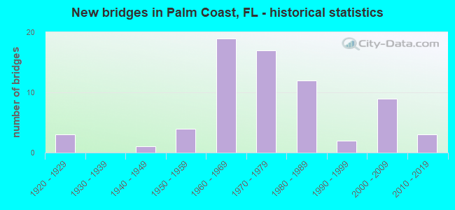
- New bridges - historical statistics
- 31920-1929
- 11940-1949
- 41950-1959
- 191960-1969
- 171970-1979
- 121980-1989
- 21990-1999
- 92000-2009
- 32010-2019
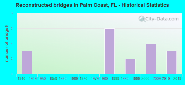
- Reconstructed bridges - Historical Statistics
- 31940-1949
- 01950-1959
- 01960-1969
- 01970-1979
- 61980-1989
- 21990-1999
- 42000-2009
- 32010-2019
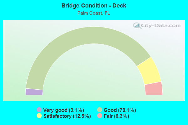
- Bridge Condition - Deck
- 3.1%Very good
- 78.1%Good
- 12.5%Satisfactory
- 6.3%Fair
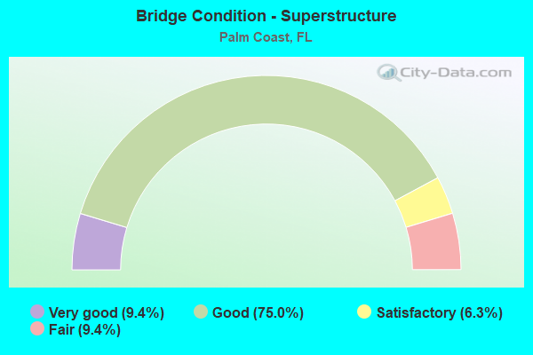
- Bridge Condition - Superstructure
- 9.4%Very good
- 75.0%Good
- 6.3%Satisfactory
- 9.4%Fair
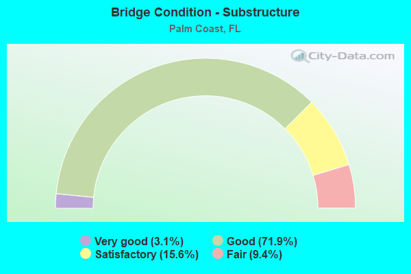
- Bridge Condition - Substructure
- 3.1%Very good
- 71.9%Good
- 15.6%Satisfactory
- 9.4%Fair
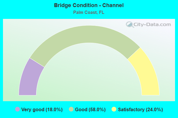
- Bridge Condition - Channel
- 18.0%Very good
- 58.0%Good
- 24.0%Satisfactory
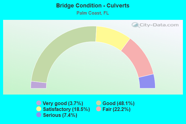
- Bridge Condition - Culverts
- 3.7%Very good
- 48.1%Good
- 18.5%Satisfactory
- 22.2%Fair
- 7.4%Serious
Find on map >> Show street view
Structure Number: 73551, Location: 0.5 Mi. East of I-95 (Lat: 29.594206, Lng: -81.239606), Route carried "on" structure: City street , Year Built: 2014, Status: Open, Structure Length: 0.84m (2.76ft), Average Daily Traffic: 501 (year 2020), Truck Traffic: 5%, Average Future Daily Traffic: 870 (year 2042), Design Load: HL 93, Features Intersected: Canal, Facility Carried by Structure: Old Kings Road
Minimum Vertical Clearance: 30+ m (98+ ft), Kilometerpoint: 0.805, Lanes on structure: 4, Owner: City or Municipal Highway Agency, Approaching Roadway Width: 18.3m (60.0ft), Skew: 20 degrees, Material/Design: Concrete, Design/Construction: Culvert, Number Of Spans In Main Unit: 3, Length of Maximum Span: 2.4m (7.9ft), Curb or Sidewalk Widths: Left: 2.4m (7.9ft), Right: 2.4m (7.9ft)
Condition: Channel: Good, Culverts: Good, Operating Rating: 84.9 metric tons, Method Used To Determine Operating Rating: Load and Resistance Factor (LRFR), Inventory Rating: 65.7 metric tons, Method Used To Determine Inventory Rating: Load and Resistance Factor (LRFR), Structural Evaluation: Better than present minimum criteria, Waterway Adequacy: Better than present minimum criteria, Approach Roadway Alignment: Equal to present desirable criteria, Designated Inspection Frequency: Every 24 months, Inspection Date: September 2020
Find on map >> Show street view
Structure Number: 735511, Location: 1.1 MI N/O Florida Park D (Lat: 29.594547, Lng: -81.222483), Route carried "on" structure: City street , Year Built: 1970, Status: Open, Structure Length: 0.67m (2.20ft), Average Daily Traffic: 5,300 (year 2021), Truck Traffic: 7%, Average Future Daily Traffic: 9,196 (year 2042), Design Load: HL 93, Features Intersected: Crandal Waterway, Facility Carried by Structure: Palm Harbor Pkwy
Minimum Vertical Clearance: 30+ m (98+ ft), Kilometerpoint: 0.000, Lanes on structure: 2, Owner: Town or Township Highway Agency, Approaching Roadway Width: 11.4m (37.4ft), Material/Design: Steel, Design/Construction: Culvert, Number Of Spans In Main Unit: 3, Length of Maximum Span: 1.8m (5.9ft)
Condition: Channel: Very good, Culverts: Serious, Operating Rating: 73.1 metric tons, Method Used To Determine Operating Rating: Load and Resistance Factor (LRFR), Inventory Rating: 56.5 metric tons, Method Used To Determine Inventory Rating: Load and Resistance Factor (LRFR), Structural Evaluation: High priority of corrective action, Waterway Adequacy: Equal to present desirable criteria, Approach Roadway Alignment: Equal to present desirable criteria, Designated Inspection Frequency: Every 24 months, Other Special Inspection Frequency: Every 6 months, Inspection Date: December 2021, Other Special Inspection Date: December 2021
Find on map >> Show street view
Structure Number: 735512, Location: 1.2 MI N/O Palm Coast Pk (Lat: 29.572725, Lng: -81.227350), Route carried "on" structure: City street , Year Built: 1970, Status: Open, Structure Length: 0.76m (2.49ft), Average Daily Traffic: 4,300 (year 2020), Truck Traffic: 4%, Average Future Daily Traffic: 7,460 (year 2042), Design Load: HL 93, Features Intersected: Mulberry Waterway, Facility Carried by Structure: N Old Kings Rd
Minimum Vertical Clearance: 30+ m (98+ ft), Kilometerpoint: 12.493, Lanes on structure: 2, Owner: Town or Township Highway Agency, Approaching Roadway Width: 7.8m (25.6ft), Material/Design: Aluminum, Iron, Design/Construction: Culvert, Number Of Spans In Main Unit: 3, Length of Maximum Span: 2.1m (6.9ft)
Condition: Channel: Satisfactory, Culverts: Good, Structural Evaluation: Better than present minimum criteria, Waterway Adequacy: Equal to present desirable criteria, Approach Roadway Alignment: Equal to present desirable criteria, Designated Inspection Frequency: Every 24 months, Inspection Date: December 2020
Find on map >> Show street view
Structure Number: 735513, Location: 300ft East of US-1 (Lat: 29.552878, Lng: -81.264272), Route carried "on" structure: City street , Year Built: 1970, Status: Open, Structure Length: 0.67m (2.20ft), Average Daily Traffic: 10,800 (year 2020), Truck Traffic: 5%, Average Future Daily Traffic: 18,360 (year 2042), Design Load: HL 93, Features Intersected: Parkview Waterway, Facility Carried by Structure: Palm Coast Pkwy
Minimum Vertical Clearance: 30+ m (98+ ft), Kilometerpoint: 0.000, Lanes on structure: 4, Owner: Town or Township Highway Agency, Approaching Roadway Width: 14.6m (47.9ft), Skew: 20 degrees, Material/Design: Aluminum, Iron, Design/Construction: Culvert, Number Of Spans In Main Unit: 1, Length of Maximum Span: 6.7m (22.0ft)
Condition: Channel: Good, Culverts: Good, Operating Rating: 58.4 metric tons, Method Used To Determine Operating Rating: Load and Resistance Factor (LRFR), Inventory Rating: 45.1 metric tons, Method Used To Determine Inventory Rating: Load and Resistance Factor (LRFR), Structural Evaluation: Better than present minimum criteria, Waterway Adequacy: Equal to present desirable criteria, Approach Roadway Alignment: Equal to present desirable criteria, Designated Inspection Frequency: Every 24 months, Underwater Inspection Frequency: Every 24 months, Inspection Date: December 2020, Underwater Inspection Date: December 2020
Find on map >> Show street view
Structure Number: 735514, Location: 0.3 MI S/O Whiteview Pkwy (Lat: 29.513469, Lng: -81.238692), Route carried "on" structure: City street , Year Built: 1970, Status: Open, Structure Length: 0.67m (2.20ft), Design Load: HL 93, Features Intersected: Pine Grove Waterway, Facility Carried by Structure: Ravenwood Dr
Minimum Vertical Clearance: 30+ m (98+ ft), Kilometerpoint: 0.000, Lanes on structure: 2, Owner: Town or Township Highway Agency, Approaching Roadway Width: 7.2m (23.6ft), Material/Design: Steel, Design/Construction: Culvert, Number Of Spans In Main Unit: 3, Length of Maximum Span: 1.8m (5.9ft)
Condition: Channel: Good, Culverts: Fair, Structural Evaluation: Somewhat better than minimum adequacy, Waterway Adequacy: Equal to present desirable criteria, Approach Roadway Alignment: Equal to present desirable criteria, Designated Inspection Frequency: Every 24 months, Underwater Inspection Frequency: Every 23 months, Inspection Date: December 2020, Underwater Inspection Date: January 2021
Find on map >> Show street view
Structure Number: 735515, Location: 0.9 MI N/O Royal Palm Pk (Lat: 29.510561, Lng: -81.251844), Route carried "on" structure: City street , Year Built: 1970, Status: Open, Structure Length: 0.91m (2.99ft), Average Daily Traffic: 2,900 (year 2021), Truck Traffic: 7%, Average Future Daily Traffic: 5,032 (year 2042), Design Load: HL 93, Features Intersected: Rippling Waterway, Facility Carried by Structure: Rymfire Dr
Minimum Vertical Clearance: 30+ m (98+ ft), Kilometerpoint: 1.506, Lanes on structure: 2, Owner: Town or Township Highway Agency, Approaching Roadway Width: 7.8m (25.6ft), Material/Design: Steel, Design/Construction: Culvert, Number Of Spans In Main Unit: 3, Length of Maximum Span: 2.4m (7.9ft)
Condition: Channel: Satisfactory, Culverts: Serious, Operating Rating: 49.6 metric tons, Method Used To Determine Operating Rating: Load and Resistance Factor (LRFR), Inventory Rating: 38.2 metric tons, Method Used To Determine Inventory Rating: Load and Resistance Factor (LRFR), Structural Evaluation: High priority of corrective action, Waterway Adequacy: Equal to present desirable criteria, Approach Roadway Alignment: Equal to present desirable criteria, Designated Inspection Frequency: Every 24 months, Other Special Inspection Frequency: Every 6 months, Inspection Date: December 2021, Other Special Inspection Date: December 2021
Find on map >> Show street view
Structure Number: 735516, Location: 1.1 MI W/O Belle Terre P (Lat: 29.497389, Lng: -81.239853), Route carried "on" structure: City street , Year Built: 1970, Status: Open, Structure Length: 0.91m (2.99ft), Average Daily Traffic: 5,900 (year 2020), Truck Traffic: 8%, Average Future Daily Traffic: 10,236 (year 2042), Design Load: HL 93, Features Intersected: Rippling Waterway, Facility Carried by Structure: Royal Palm Pkwy
Minimum Vertical Clearance: 30+ m (98+ ft), Kilometerpoint: 2.430, Lanes on structure: 2, Owner: Town or Township Highway Agency, Approaching Roadway Width: 9.8m (32.2ft), Material/Design: Steel, Design/Construction: Culvert, Number Of Spans In Main Unit: 3, Length of Maximum Span: 2.4m (7.9ft)
Condition: Channel: Satisfactory, Culverts: Fair, Structural Evaluation: Somewhat better than minimum adequacy, Waterway Adequacy: Equal to present desirable criteria, Approach Roadway Alignment: Equal to present desirable criteria, Designated Inspection Frequency: Every 24 months, Underwater Inspection Frequency: Every 24 months, Inspection Date: December 2020, Underwater Inspection Date: December 2020, Wearing Surface/Protective System: Deck Protection: Other
Find on map >> Show street view
Structure Number: 735517, Location: 0.3 MI W/O Belle Terre P (Lat: 29.492181, Lng: -81.225808), Route carried "on" structure: City street , Year Built: 1970, Status: Open, Structure Length: 0.73m (2.40ft), Average Daily Traffic: 6,300 (year 2020), Truck Traffic: 10%, Average Future Daily Traffic: 10,930 (year 2042), Design Load: HL 93, Features Intersected: East Waterway, Facility Carried by Structure: Easthampton Blvd
Minimum Vertical Clearance: 30+ m (98+ ft), Kilometerpoint: 1.954, Lanes on structure: 2, Owner: Town or Township Highway Agency, Approaching Roadway Width: 7.8m (25.6ft), Material/Design: Steel, Design/Construction: Culvert, Number Of Spans In Main Unit: 3, Length of Maximum Span: 1.8m (5.9ft)
Condition: Channel: Good, Culverts: Fair, Structural Evaluation: Somewhat better than minimum adequacy, Waterway Adequacy: Equal to present desirable criteria, Approach Roadway Alignment: Equal to present desirable criteria, Designated Inspection Frequency: Every 24 months, Underwater Inspection Frequency: Every 23 months, Inspection Date: December 2020, Underwater Inspection Date: January 2021
Find on map >> Show street view
Structure Number: 735518, Location: 0.1 M S Palm Coast Pkwy (Lat: 29.557972, Lng: -81.202125), Route carried "on" structure: City street , Year Built: 1980, Status: Open, Structure Length: 0.62m (2.03ft), Average Daily Traffic: 1,001 (year 2021), Truck Traffic: 10%, Average Future Daily Traffic: 2,001 (year 2042), Features Intersected: Joe Canal, Facility Carried by Structure: Clubhouse Drive
Minimum Vertical Clearance: 30+ m (98+ ft), Kilometerpoint: 0.000, Lanes on structure: 2, Owner: City or Municipal Highway Agency, Approaching Roadway Width: 8.2m (26.9ft), Material/Design: Aluminum, Iron, Design/Construction: Culvert, Number Of Spans In Main Unit: 1, Length of Maximum Span: 6.2m (20.3ft)
Condition: Channel: Good, Culverts: Good, Structural Evaluation: Better than present minimum criteria, Waterway Adequacy: Better than present minimum criteria, Approach Roadway Alignment: Equal to present desirable criteria, Designated Inspection Frequency: Every 24 months, Inspection Date: June 2021
Find on map >> Show street view
Structure Number: 780034, Location: I-95 / US-1 (Lat: 29.662272, Lng: -81.287542), Route carried "on" structure: Interstate 95, Year Built: 1965, Year Reconstructed: 1992, Status: Open, Structure Length: 6.43m (21.10ft), Average Daily Traffic: 29,250 (year 2020), Truck Traffic: 8%, Average Future Daily Traffic: 50,749 (year 2042), Design Load: HS 20+Mod, Features Intersected: US-1 (SR-5)
Minimum Vertical Clearance: 30+ m (98+ ft), Kilometerpoint: 1.493, Lanes on structure: 3, Lanes under structure: 4, Base Highway Network: Yes, Owner: State Highway Agency, Approaching Roadway Width: 18.1m (59.4ft), Skew: 3 degrees, Material/Design: Prestressed concrete, Design/Construction: Stringer/Multi-beam, Number Of Spans In Main Unit: 4, Length of Maximum Span: 19.2m (63.0ft), Curb-To-Curb Width: 17.1m (56.1ft), Out-to-Out Width: 18.0m (59.1ft)
Condition: Deck: Good, Superstructure: Good, Substructure: Good, Operating Rating: 56.8 metric tons, Method Used To Determine Operating Rating: Load Factor (LF), Inventory Rating: 34.0 metric tons, Method Used To Determine Inventory Rating: Load Factor (LF), Structural Evaluation: Better than present minimum criteria, Deck Geometry: Equal to present minimum criteria, Underclear: Meets minimum limits, Approach Roadway Alignment: Equal to present desirable criteria, Designated Inspection Frequency: Every 24 months, Inspection Date: March 2021, Deck Structure Type: Concrete Cast-file-Place
Find on map >> Show street view
Structure Number: 780035, Location: I-95 / US-1 (Lat: 29.662500, Lng: -81.287500), Route carried "on" structure: Interstate 95, Year Built: 1965, Year Reconstructed: 1992, Status: Open, Structure Length: 6.43m (21.10ft), Average Daily Traffic: 29,250 (year 2020), Truck Traffic: 8%, Average Future Daily Traffic: 50,749 (year 2042), Design Load: HS 20+Mod, Features Intersected: US-1 (SR-5)
Minimum Vertical Clearance: 30+ m (98+ ft), Kilometerpoint: 1.497, Lanes on structure: 3, Lanes under structure: 4, Base Highway Network: Yes, Owner: State Highway Agency, Approaching Roadway Width: 17.4m (57.1ft), Skew: 3 degrees, Material/Design: Prestressed concrete, Design/Construction: Stringer/Multi-beam, Number Of Spans In Main Unit: 4, Length of Maximum Span: 19.2m (63.0ft), Curb-To-Curb Width: 17.1m (56.1ft), Out-to-Out Width: 18.0m (59.1ft)
Condition: Deck: Good, Superstructure: Good, Substructure: Good, Operating Rating: 56.8 metric tons, Method Used To Determine Operating Rating: Load Factor (LF), Inventory Rating: 34.0 metric tons, Method Used To Determine Inventory Rating: Load Factor (LF), Structural Evaluation: Better than present minimum criteria, Deck Geometry: Equal to present minimum criteria, Underclear: Meets minimum limits, Approach Roadway Alignment: Equal to present desirable criteria, Designated Inspection Frequency: Every 24 months, Inspection Date: March 2021, Deck Structure Type: Concrete Cast-file-Place
Find on map >> Show street view
Structure Number: 780036, Location: 1.2 MI. N. OF US-1 (Lat: 29.672047, Lng: -81.304800), Route carried "on" structure: Interstate 95, Year Built: 1965, Year Reconstructed: 1992, Status: Open, Structure Length: 6.19m (20.31ft), Average Daily Traffic: 29,250 (year 2020), Truck Traffic: 9%, Average Future Daily Traffic: 50,749 (year 2042), Design Load: HS 20+Mod, Features Intersected: CSXRR
Minimum Vertical Clearance: 30+ m (98+ ft), Kilometerpoint: 3.487, Lanes on structure: 3, Base Highway Network: Yes, Owner: State Highway Agency, Approaching Roadway Width: 17.4m (57.1ft), Skew: 4 degrees, Material/Design: Prestressed concrete, Design/Construction: Stringer/Multi-beam, Number Of Spans In Main Unit: 3, Length of Maximum Span: 20.7m (67.9ft), Curb-To-Curb Width: 17.1m (56.1ft), Out-to-Out Width: 18.0m (59.1ft)
Condition: Deck: Good, Superstructure: Good, Substructure: Good, Operating Rating: 57.2 metric tons, Method Used To Determine Operating Rating: Load Factor (LF), Inventory Rating: 34.5 metric tons, Method Used To Determine Inventory Rating: Load Factor (LF), Structural Evaluation: Better than present minimum criteria, Deck Geometry: Equal to present minimum criteria, Underclear: Equal to present minimum criteria, Approach Roadway Alignment: Equal to present desirable criteria, Designated Inspection Frequency: Every 24 months, Inspection Date: June 2021, Deck Structure Type: Concrete Cast-file-Place
Find on map >> Show street view
Structure Number: 780037, Location: 1.2 MI. N. OF US-1 (Lat: 29.672222, Lng: -81.304722), Route carried "on" structure: Interstate 95, Year Built: 1965, Year Reconstructed: 1992, Status: Open, Structure Length: 6.19m (20.31ft), Average Daily Traffic: 29,250 (year 2020), Truck Traffic: 9%, Average Future Daily Traffic: 50,749 (year 2042), Design Load: HS 20+Mod, Features Intersected: CSXRR
Minimum Vertical Clearance: 30+ m (98+ ft), Kilometerpoint: 3.494, Lanes on structure: 3, Base Highway Network: Yes, Owner: State Highway Agency, Approaching Roadway Width: 17.4m (57.1ft), Skew: 4 degrees, Material/Design: Prestressed concrete, Design/Construction: Stringer/Multi-beam, Number Of Spans In Main Unit: 3, Length of Maximum Span: 20.7m (67.9ft), Curb-To-Curb Width: 17.1m (56.1ft), Out-to-Out Width: 18.0m (59.1ft)
Condition: Deck: Good, Superstructure: Good, Substructure: Good, Operating Rating: 57.2 metric tons, Method Used To Determine Operating Rating: Load Factor (LF), Inventory Rating: 34.5 metric tons, Method Used To Determine Inventory Rating: Load Factor (LF), Structural Evaluation: Better than present minimum criteria, Deck Geometry: Equal to present minimum criteria, Underclear: Equal to present minimum criteria, Approach Roadway Alignment: Equal to present desirable criteria, Designated Inspection Frequency: Every 24 months, Inspection Date: June 2021, Deck Structure Type: Concrete Cast-file-Place
Find on map >> Show street view
Structure Number: 780039, Location: 0.3 MI. N. OF US-1 (Lat: 29.664444, Lng: -81.291111), Route carried "on" structure: Interstate 95, Year Built: 1965, Year Reconstructed: 1992, Status: Open, Structure Length: 0.98m (3.22ft), Average Daily Traffic: 58,500 (year 2020), Truck Traffic: 11%, Average Future Daily Traffic: 101,498 (year 2042), Design Load: HS 20, Features Intersected: FLORIDA CRACKER CREEK
Minimum Vertical Clearance: 30+ m (98+ ft), Kilometerpoint: 1.914, Lanes on structure: 8, Base Highway Network: Yes, Owner: State Highway Agency, Approaching Roadway Width: 42.8m (140.4ft), Skew: 10 degrees, Material/Design: Concrete, Design/Construction: Culvert, Number Of Spans In Main Unit: 3, Length of Maximum Span: 3.0m (9.8ft)
Condition: Channel: Satisfactory, Culverts: Fair, Operating Rating: 39.4 metric tons, Method Used To Determine Operating Rating: Load Factor (LF), Inventory Rating: 23.6 metric tons, Method Used To Determine Inventory Rating: Load Factor (LF), Structural Evaluation: Somewhat better than minimum adequacy, Waterway Adequacy: Better than present minimum criteria, Approach Roadway Alignment: Equal to present desirable criteria, Designated Inspection Frequency: Every 24 months, Inspection Date: Febuary 2022
Find on map >> Show street view
Structure Number: 784008, Location: 0.2 MI W OF US 1 (Lat: 29.658667, Lng: -81.290167), Route carried "on" structure: County highway 204, Year Built: 1948, Status: Open, Structure Length: 0.97m (3.18ft), Average Daily Traffic: 2,700 (year 2020), Truck Traffic: 2%, Average Future Daily Traffic: 4,685 (year 2042), Features Intersected: BRANCH OF PELLICER CREEK
Minimum Vertical Clearance: 30+ m (98+ ft), Kilometerpoint: 8.723, Lanes on structure: 2, Owner: County Highway Agency, Approaching Roadway Width: 8.4m (27.6ft), Material/Design: Concrete, Design/Construction: Culvert, Number Of Spans In Main Unit: 3, Length of Maximum Span: 3.3m (10.8ft)
Condition: Channel: Good, Culverts: Satisfactory, Operating Rating: 36.6 metric tons, Method Used To Determine Operating Rating: Load and Resistance Factor (LRFR), Inventory Rating: 23.5 metric tons, Method Used To Determine Inventory Rating: Load and Resistance Factor (LRFR), Structural Evaluation: Equal to present minimum criteria, Waterway Adequacy: Better than present minimum criteria, Approach Roadway Alignment: Equal to present desirable criteria, Length Of Structure Improvement: 0.98m (3.22ft), Designated Inspection Frequency: Every 24 months, Underwater Inspection Frequency: Every 24 months, Inspection Date: October 2020, Underwater Inspection Date: October 2020, Bridge Improvement Cost: $1,000, Roadway Improvement Cost: $1,000, Total Project Cost: $3,000
Find on map >> Show street view
Structure Number: 790084, Location: Old Dixie Hwy over I-95 (Lat: 29.403769, Lng: -81.155186), Route carried "on" structure: County highway , Year Built: 1964, Status: Open, Structure Length: 6.95m (22.80ft), Average Daily Traffic: 3,100 (year 2020), Truck Traffic: 7%, Average Future Daily Traffic: 5,378 (year 2042), Design Load: H 20, Features Intersected: I-95, Facility Carried by Structure: Old Dixie Highway
Minimum Vertical Clearance: 30+ m (98+ ft), Kilometerpoint: 10.715, Lanes on structure: 2, Lanes under structure: 6, Owner: State Highway Agency, Approaching Roadway Width: 10.4m (34.1ft), Skew: 2 degrees, Material/Design: Prestressed concrete, Design/Construction: Stringer/Multi-beam, Number Of Spans In Main Unit: 4, Length of Maximum Span: 22.9m (75.1ft), Curb-To-Curb Width: 8.5m (27.9ft), Out-to-Out Width: 10.4m (34.1ft)
Condition: Deck: Satisfactory, Superstructure: Good, Substructure: Good, Operating Rating: 60.1 metric tons, Method Used To Determine Operating Rating: Load Factor (LF), Inventory Rating: 37.0 metric tons, Method Used To Determine Inventory Rating: Load Factor (LF), Structural Evaluation: Better than present minimum criteria, Deck Geometry: Meets minimum limits, Underclear: Meets minimum limits, Approach Roadway Alignment: Equal to present desirable criteria, Designated Inspection Frequency: Every 24 months, Inspection Date: April 2021, Deck Structure Type: Concrete Cast-file-Place
Find on map >> Show street view
Structure Number: 794074, Location: 0.7 Mi N of Old Dixie Hwy (Lat: 29.414089, Lng: -81.148136), Route carried "on" structure: County highway 2001, Year Built: 1972, Status: Open, Structure Length: 1.19m (3.90ft), Average Daily Traffic: 3,800 (year 2020), Truck Traffic: 9%, Average Future Daily Traffic: 6,593 (year 2042), Design Load: H 20, Features Intersected: Canal to Bulow Creek, Facility Carried by Structure: Old Kings Rd.
Minimum Vertical Clearance: 30+ m (98+ ft), Kilometerpoint: 1.138, Lanes on structure: 2, Owner: County Highway Agency, Approaching Roadway Width: 7.7m (25.3ft), Skew: 1 degrees, Material/Design: Concrete, Design/Construction: Culvert, Number Of Spans In Main Unit: 3, Length of Maximum Span: 3.7m (12.1ft)
Condition: Channel: Satisfactory, Culverts: Satisfactory, Operating Rating: 44.8 metric tons, Method Used To Determine Operating Rating: Load Factor (LF), Inventory Rating: 26.9 metric tons, Method Used To Determine Inventory Rating: Load Factor (LF), Structural Evaluation: Equal to present minimum criteria, Waterway Adequacy: Equal to present minimum criteria, Approach Roadway Alignment: Better than present minimum criteria, Designated Inspection Frequency: Every 24 months, Inspection Date: April 2020
Find on map >> Show street view
Structure Number: 730038, Location: Old Kings Rd over I-95 (Lat: 29.637306, Lng: -81.268500), Route carried "under" structure: Interstate 95, Year Built: 1965, Structure Length: 0. m, Average Daily Traffic: 58,500 (year 2020), Truck Traffic: 8%, Features Intersected: I-95, Facility Carried by Structure: Old Kings Road
Minimum Vertical Clearance: 5.43m (17.81ft), Kilometerpoint: 28.270, Lanes on structure: 2, Lanes under structure: 6, Material/Design: Prestressed concrete, Design/Construction: Stringer/Multi-beam, Length of Maximum Span: 32.0m (105.0ft)
Find on map >> Show street view
Structure Number: 730047, Location: I-95 -Town Center Blvd (Lat: 29.497250, Lng: -81.191889), Route carried "under" structure: Business County highway , Year Built: 1965, Structure Length: 0. m, Average Daily Traffic: 4,400 (year 2020), Truck Traffic: 8%, Features Intersected: Town Center Blvd., Facility Carried by Structure: I-95
Minimum Vertical Clearance: 6.49m (21.29ft), Kilometerpoint: 10.678, Lanes on structure: 6, Lanes under structure: 2, Material/Design: Prestressed concrete, Design/Construction: Stringer/Multi-beam, Length of Maximum Span: 15.9m (52.2ft)
Find on map >> Show street view
Structure Number: 730057, Location: Palm Coast Pkwy WB I-95 (Lat: 29.554028, Lng: -81.218753), Route carried "under" structure: Interstate 95, Year Built: 1981, Structure Length: 0. m, Average Daily Traffic: 76,000 (year 2020), Truck Traffic: 8%, Features Intersected: I-95, Facility Carried by Structure: Palm Coast Pkwy WB
Minimum Vertical Clearance: 5.12m (16.80ft), Kilometerpoint: 17.822, Lanes on structure: 3, Lanes under structure: 6, Material/Design: Prestressed concrete, Design/Construction: Stringer/Multi-beam, Length of Maximum Span: 29.2m (95.8ft)
Find on map >> Show street view
Structure Number: 73006, Location: Palm Coast Pkwy EB I-95 (Lat: 29.553867, Lng: -81.218675), Route carried "under" structure: Interstate 95, Year Built: 1995, Structure Length: 0. m, Average Daily Traffic: 76,000 (year 2020), Truck Traffic: 8%, Features Intersected: I-95, Facility Carried by Structure: Palm Coast Pkwy EB
Minimum Vertical Clearance: 5.12m (16.80ft), Kilometerpoint: 17.814, Lanes on structure: 3, Lanes under structure: 6, Material/Design: Prestressed concrete, Design/Construction: Stringer/Multi-beam, Length of Maximum Span: 29.2m (95.8ft)
Find on map >> Show street view
Structure Number: 730072, Location: I-95 over SR-100 (Lat: 29.475889, Lng: -81.183750), Route carried "under" structure: State highway 100, Year Built: 2007, Structure Length: 0. m, Average Daily Traffic: 26,000 (year 2020), Truck Traffic: 6%, Features Intersected: SR-100, Facility Carried by Structure: I-95
Minimum Vertical Clearance: 5.09m (16.70ft), Kilometerpoint: 7.582, Lanes on structure: 6, Lanes under structure: 4, Material/Design: Steel, Design/Construction: Stringer/Multi-beam, Length of Maximum Span: 74.1m (243.1ft)
Find on map >> Show street view
Structure Number: 734071, Location: 2.7 Miles E of I-95 (Lat: 29.573686, Lng: -81.189111), Route carried "under" structure: State highway A1A, Year Built: 1988, Structure Length: 0. m, Average Daily Traffic: 5,800 (year 2020), Truck Traffic: 6%, Features Intersected: Intracoastal Waterway, Facility Carried by Structure: Palm Coast Parkway
Minimum Vertical Clearance: 5.55m (18.21ft), Kilometerpoint: 18.826, Lanes on structure: 2, Lanes under structure: 2, Material/Design: Prestressed concrete, Design/Construction: Stringer/Multi-beam, Length of Maximum Span: 39.6m (129.9ft)
Find on map >> Show street view
Structure Number: 734071, Location: 2.7 Miles E of I-95 (Lat: 29.573686, Lng: -81.189111), Route carried "under" structure: City street , Year Built: 1988, Structure Length: 0. m, Average Daily Traffic: 5,000 (year 2020), Truck Traffic: 7%, Features Intersected: Intracoastal Waterway, Facility Carried by Structure: Palm Coast Parkway
Minimum Vertical Clearance: 9.30m (30.51ft), Kilometerpoint: 0.752, Lanes on structure: 2, Lanes under structure: 4, Material/Design: Prestressed concrete, Design/Construction: Stringer/Multi-beam, Length of Maximum Span: 39.6m (129.9ft)
Find on map >> Show street view
Structure Number: 739001, Location: Equestrian Bridge - I-95 (Lat: 29.646056, Lng: -81.273278), Route carried "under" structure: Interstate 95, Year Built: 2002, Structure Length: 0. m, Average Daily Traffic: 58,500 (year 2020), Truck Traffic: 8%, Features Intersected: I-95, Facility Carried by Structure: Equestrian Bridge
Minimum Vertical Clearance: 5.12m (16.80ft), Kilometerpoint: 29.324, Lanes under structure: 6, Material/Design: Prestressed concrete, Design/Construction: Stringer/Multi-beam, Length of Maximum Span: 29.9m (98.1ft)
Find on map >> Show street view
Structure Number: 780034, Location: I-95 / US-1 (Lat: 29.662272, Lng: -81.287542), Route carried "under" structure: US 1, Year Built: 1965, Structure Length: 0. m, Average Daily Traffic: 12,700 (year 2020), Truck Traffic: 4%, Features Intersected: US-1 (SR-5), Facility Carried by Structure: I-95 SB (SR-9)
Minimum Vertical Clearance: 4.71m (15.45ft), Kilometerpoint: 1.176, Lanes on structure: 3, Lanes under structure: 4, Material/Design: Prestressed concrete, Design/Construction: Stringer/Multi-beam, Length of Maximum Span: 19.2m (63.0ft)
Find on map >> Show street view
Structure Number: 780035, Location: I-95 / US-1 (Lat: 29.662500, Lng: -81.287500), Route carried "under" structure: US 1, Year Built: 1965, Structure Length: 0. m, Average Daily Traffic: 12,700 (year 2020), Truck Traffic: 4%, Features Intersected: US-1 (SR-5), Facility Carried by Structure: I-95 NB (SR-9)
Minimum Vertical Clearance: 4.75m (15.58ft), Kilometerpoint: 1.204, Lanes on structure: 3, Lanes under structure: 4, Material/Design: Prestressed concrete, Design/Construction: Stringer/Multi-beam, Length of Maximum Span: 19.2m (63.0ft)
Find on map >> Show street view
Structure Number: 790084, Location: Old Dixie Hwy over I-95 (Lat: 29.403769, Lng: -81.155186), Route carried "under" structure: Interstate 95, Year Built: 1964, Structure Length: 0. m, Average Daily Traffic: 60,500 (year 2020), Truck Traffic: 8%, Features Intersected: I-95, Facility Carried by Structure: Old Dixie Highway
Minimum Vertical Clearance: 5.06m (16.60ft), Kilometerpoint: 0.097, Lanes on structure: 2, Lanes under structure: 6, Material/Design: Prestressed concrete, Design/Construction: Stringer/Multi-beam, Length of Maximum Span: 22.9m (75.1ft)