Bridge Statistics for Perry, Georgia (GA)
Condition, Traffic, Stress, Structural Evaluation, Project Costs
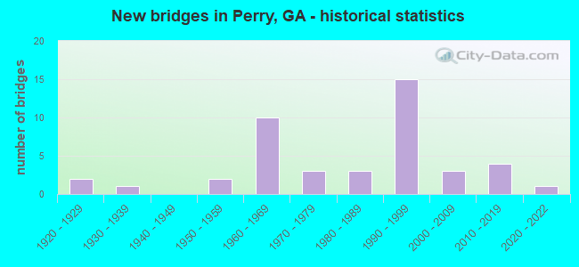
- New bridges - historical statistics
- 21920-1929
- 11930-1939
- 21950-1959
- 101960-1969
- 31970-1979
- 31980-1989
- 151990-1999
- 32000-2009
- 42010-2019
- 12020-2022
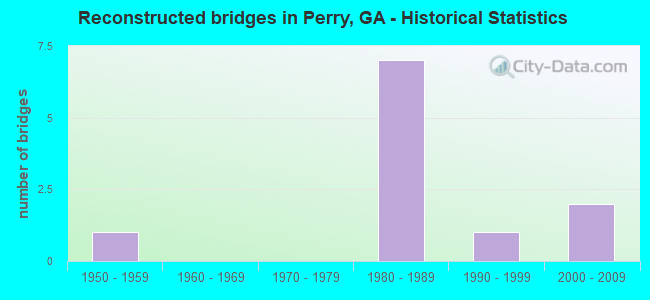
- Reconstructed bridges - Historical Statistics
- 11950-1959
- 01960-1969
- 01970-1979
- 71980-1989
- 11990-1999
- 22000-2009
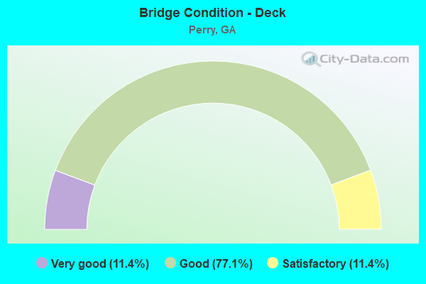
- Bridge Condition - Deck
- 11.4%Very good
- 77.1%Good
- 11.4%Satisfactory
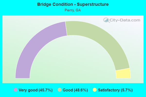
- Bridge Condition - Superstructure
- 45.7%Very good
- 48.6%Good
- 5.7%Satisfactory
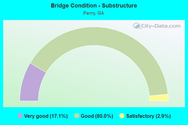
- Bridge Condition - Substructure
- 17.1%Very good
- 80.0%Good
- 2.9%Satisfactory
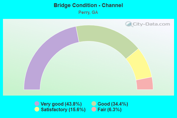
- Bridge Condition - Channel
- 43.8%Very good
- 34.4%Good
- 15.6%Satisfactory
- 6.3%Fair
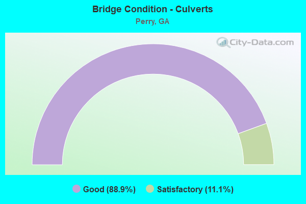
- Bridge Condition - Culverts
- 88.9%Good
- 11.1%Satisfactory
Find on map >> Show street view
Structure Number: 153505, Location: 0.5 MI W OF BONAIRE (Lat: 32.551981, Lng: -83.598567), Route carried "on" structure: State highway 96, Year Built: 2016, Status: Open, Structure Length: 2.93m (9.61ft), Average Daily Traffic: 7,830 (year 2012), Truck Traffic: 1%, Average Future Daily Traffic: 11,745 (year 2032), Design Load: HS 20+Mod, Features Intersected: NORFOLK SOUTHERN RAILWAY
Minimum Vertical Clearance: 30+ m (98+ ft), Kilometerpoint: 11.265, Lanes on structure: 5, Base Highway Network: Yes, Owner: State Highway Agency, Approaching Roadway Width: 14.6m (47.9ft), Skew: 10 degrees, Material/Design: Prestressed concrete, Design/Construction: Stringer/Multi-beam, Number Of Spans In Main Unit: 1, Length of Maximum Span: 29.3m (96.1ft), Curb-To-Curb Width: 30.5m (100.1ft), Out-to-Out Width: 31.6m (103.7ft)
Condition: Deck: Very good, Superstructure: Very good, Substructure: Very good, Operating Rating: 72.5 metric tons, Method Used To Determine Operating Rating: Load Factor (LF), Inventory Rating: 35.3 metric tons, Method Used To Determine Inventory Rating: Load Factor (LF), Structural Evaluation: Equal to present desirable criteria, Deck Geometry: Superior to present desirable criteria, Underclear: Better than present minimum criteria, Approach Roadway Alignment: Equal to present desirable criteria, Length Of Structure Improvement: 3.51m (11.52ft), Designated Inspection Frequency: Every 24 months, Inspection Date: July 2021, Bridge Improvement Cost: $8,510,000, Roadway Improvement Cost: $851,000, Total Project Cost: $12,765,000 ( Estimate for 2017), Deck Structure Type: Concrete Cast-file-Place
Find on map >> Show street view
Structure Number: 1535054, Location: PERRY - WESTSIDE (Lat: 32.455586, Lng: -83.779106), Route carried "on" structure: County highway 206, Year Built: 2020, Status: Open, Structure Length: 3.05m (10.01ft), Average Daily Traffic: 100 (year 2012), Truck Traffic: 1%, Average Future Daily Traffic: 150 (year 2032), Design Load: HS 20+Mod, Features Intersected: BIG INDIAN CREEK, Facility Carried by Structure: MOSS OAKS ROAD
Minimum Vertical Clearance: 30+ m (98+ ft), Kilometerpoint: 1.609, Lanes on structure: 2, Base Highway Network: Yes, Owner: County Highway Agency, Approaching Roadway Width: 7.3m (24.0ft), Material/Design: Concrete, Design/Construction: Slab, Number Of Spans In Main Unit: 5, Length of Maximum Span: 6.1m (20.0ft), Curb-To-Curb Width: 9.8m (32.2ft), Out-to-Out Width: 10.5m (34.4ft)
Condition: Deck: Very good, Superstructure: Very good, Substructure: Very good, Channel: Very good, Operating Rating: 67.1 metric tons, Method Used To Determine Operating Rating: Load Factor (LF), Inventory Rating: 39.9 metric tons, Method Used To Determine Inventory Rating: Load Factor (LF), Structural Evaluation: Equal to present desirable criteria, Deck Geometry: Equal to present desirable criteria, Waterway Adequacy: Equal to present desirable criteria, Approach Roadway Alignment: Equal to present desirable criteria, Length Of Structure Improvement: 3.66m (12.01ft), Designated Inspection Frequency: Every 24 months, Underwater Inspection Frequency: Every 60 months, Inspection Date: August 2021, Underwater Inspection Date: May 2021, Bridge Improvement Cost: $8,880,000, Roadway Improvement Cost: $888,000, Total Project Cost: $13,320,000 ( Estimate for 2020), Deck Structure Type: Concrete Cast-file-Place
Find on map >> Show street view
Structure Number: 2255001, Location: 6.5 MI SE OF FT VALLEY (Lat: 32.460408, Lng: -83.816978), Route carried "on" structure: County highway 5, Year Built: 1979, Status: Posted for load, Structure Length: 4.27m (14.01ft), Average Daily Traffic: 600 (year 2011), Truck Traffic: 1%, Average Future Daily Traffic: 900 (year 2031), Design Load: HS 15, Features Intersected: BIG INDIAN CREEK, Facility Carried by Structure: CLOPINE LAKE RD
Minimum Vertical Clearance: 30+ m (98+ ft), Kilometerpoint: 1.609, Lanes on structure: 2, Base Highway Network: Yes, Owner: County Highway Agency, Approaching Roadway Width: 6.1m (20.0ft), Material/Design: Prestressed concrete, Design/Construction: Slab, Number Of Spans In Main Unit: 7, Length of Maximum Span: 6.1m (20.0ft), Curb-To-Curb Width: 9.8m (32.2ft), Out-to-Out Width: 10.6m (34.8ft)
Condition: Deck: Good, Superstructure: Good, Substructure: Good, Channel: Good, Operating Rating: 42.6 metric tons, Method Used To Determine Operating Rating: Allowable Stress (AS), Inventory Rating: 23.5 metric tons, Method Used To Determine Inventory Rating: Allowable Stress (AS), Structural Evaluation: Equal to present minimum criteria, Deck Geometry: Equal to present minimum criteria, Waterway Adequacy: Equal to present desirable criteria, Approach Roadway Alignment: Better than present minimum criteria, Designated Inspection Frequency: Every 24 months, Inspection Date: November 2020, Bridge Improvement Cost: $547,000, Roadway Improvement Cost: $55,000, Total Project Cost: $821,000, Deck Structure Type: Concrete Precast Panels, Wearing Surface/Protective System: Wearing Surface: Bituminous
Find on map >> Show street view
Structure Number: 1530006, Location: PERRY - SW SECTION (Lat: 32.446778, Lng: -83.754589), Route carried "under" structure: Interstate 75, Structure Length: 0. m, Average Daily Traffic: 46,590 (year 2009), Truck Traffic: 40%, Features Intersected: SR 7 (US 41), Facility Carried by Structure: US 41- SR 127
Minimum Vertical Clearance: 5.51m (18.08ft), Kilometerpoint: 217.262, Lanes on structure: 5, Length of Maximum Span: 0.0m
Find on map >> Show street view
Structure Number: 1530031, Location: 2.7 MI N OF PERRY (Lat: 32.511078, Lng: -83.743111), Route carried "under" structure: Interstate 75, Structure Length: 0. m, Average Daily Traffic: 57,490 (year 1998), Truck Traffic: 40%, Features Intersected: CR 195 TODD ROAD, Facility Carried by Structure: TODD ROAD
Minimum Vertical Clearance: 5.23m (17.16ft), Kilometerpoint: 223.699, Lanes on structure: 2, Length of Maximum Span: 0.0m
Find on map >> Show street view
Structure Number: 1530052, Location: PERRY - NW SECTION (Lat: 32.471647, Lng: -83.743853), Route carried "under" structure: US 341, Structure Length: 0. m, Average Daily Traffic: 18,260 (year 1998), Truck Traffic: 1%, Features Intersected: I-75 (EXIT136), Facility Carried by Structure: I-75
Minimum Vertical Clearance: 4.90m (16.08ft), Kilometerpoint: 24.140, Lanes on structure: 6, Length of Maximum Span: 0.0m
Find on map >> Show street view
Structure Number: 1530056, Location: 6 MI S OF PERRY (Lat: 32.382269, Lng: -83.768108), Route carried "under" structure: Interstate 75, Structure Length: 0. m, Average Daily Traffic: 43,400 (year 1998), Truck Traffic: 40%, Features Intersected: CR 543 FIRETOWER ROAD, Facility Carried by Structure: FIRETOWER ROAD
Minimum Vertical Clearance: 5.18m (16.99ft), Kilometerpoint: 209.215, Lanes on structure: 2, Length of Maximum Span: 0.0m
Find on map >> Show street view
Structure Number: 1530058, Location: PERRY - WESTSIDE (Lat: 32.455150, Lng: -83.752178), Route carried "under" structure: Interstate 75, Structure Length: 0. m, Average Daily Traffic: 46,590 (year 1998), Truck Traffic: 40%, Features Intersected: CS 622 JULIANN DRIVE, Facility Carried by Structure: GAINES DRIVE
Minimum Vertical Clearance: 5.25m (17.22ft), Kilometerpoint: 217.262, Lanes on structure: 2, Length of Maximum Span: 0.0m
Find on map >> Show street view
Structure Number: 1530079, Location: 7 MI SE OF PERRY (Lat: 32.410689, Lng: -83.635350), Route carried "under" structure: US 341, Structure Length: 0. m, Average Daily Traffic: 4,330 (year 2012), Truck Traffic: 1%, Features Intersected: SR 11 (US 341)-CONYVER, Facility Carried by Structure: MATL CONVEYOR BELT
Minimum Vertical Clearance: 5.94m (19.49ft), Kilometerpoint: 9.656, Length of Maximum Span: 0.0m
Find on map >> Show street view
Structure Number: 1530084, Location: 2 MI N OF PERRY (Lat: 32.493239, Lng: -83.742639), Route carried "under" structure: Interstate 75, Structure Length: 0. m, Average Daily Traffic: 57,490 (year 1998), Truck Traffic: 45%, Features Intersected: SR 11 CONNECTOR, Facility Carried by Structure: S.R. 11 CONNECTOR
Minimum Vertical Clearance: 5.38m (17.65ft), Kilometerpoint: 222.090, Lanes on structure: 3, Length of Maximum Span: 0.0m
Find on map >> Show street view
Structure Number: 1535031, Location: SOUTH PERRY (Lat: 32.431592, Lng: -83.756944), Route carried "under" structure: Interstate 75, Structure Length: 0. m, Average Daily Traffic: 43,400 (year 1998), Truck Traffic: 40%, Features Intersected: CS00835, Facility Carried by Structure: SOUTH PERRY PKWY
Minimum Vertical Clearance: 5.58m (18.31ft), Kilometerpoint: 215.652, Lanes on structure: 5, Length of Maximum Span: 0.0m