Bridge Statistics for Phoenixville, Pennsylvania (PA)
Condition, Traffic, Stress, Structural Evaluation, Project Costs

- New bridges - historical statistics
- 5Before 1900
- 31910-1919
- 11920-1929
- 21930-1939
- 31940-1949
- 31950-1959
- 61960-1969
- 151970-1979
- 21980-1989
- 11990-1999
- 22000-2009
- 52010-2019
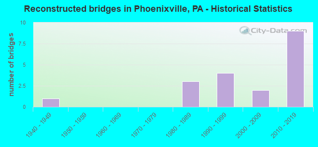
- Reconstructed bridges - Historical Statistics
- 11940-1949
- 01950-1959
- 01960-1969
- 01970-1979
- 31980-1989
- 41990-1999
- 22000-2009
- 92010-2019
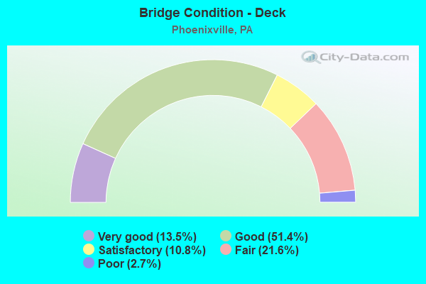
- Bridge Condition - Deck
- 13.5%Very good
- 51.4%Good
- 10.8%Satisfactory
- 21.6%Fair
- 2.7%Poor
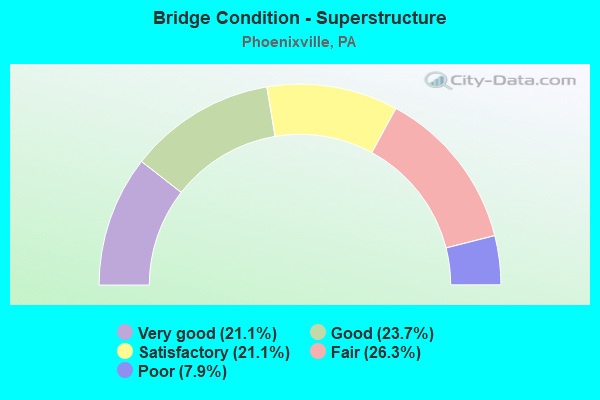
- Bridge Condition - Superstructure
- 21.1%Very good
- 23.7%Good
- 21.1%Satisfactory
- 26.3%Fair
- 7.9%Poor
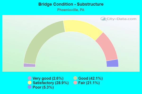
- Bridge Condition - Substructure
- 2.6%Very good
- 42.1%Good
- 28.9%Satisfactory
- 21.1%Fair
- 5.3%Poor
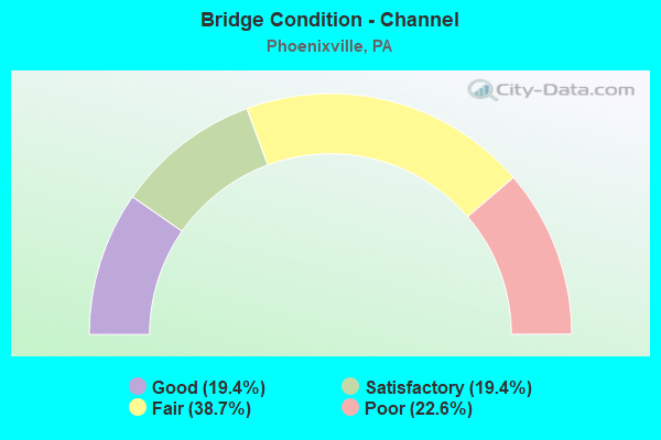
- Bridge Condition - Channel
- 19.4%Good
- 19.4%Satisfactory
- 38.7%Fair
- 22.6%Poor
Find on map >> Show street view
Structure Number: 3309, Location: RATTIGAN NO.4 (Lat: 40.894578, Lng: -79.689256), Route carried "on" structure: State highway , Year Built: 1941, Status: Open, Structure Length: 0.64m (2.10ft), Average Daily Traffic: 152 (year 2021), Truck Traffic: 4%, Average Future Daily Traffic: 244 (year 2032), Design Load: H 20, Features Intersected: TRIB TO BUFFALO CREEK, Facility Carried by Structure: SR4007
Minimum Vertical Clearance: 30+ m (98+ ft), Kilometerpoint: 0.000, Lanes on structure: 2, Owner: State Highway Agency, Approaching Roadway Width: 6.1m (20.0ft), Material/Design: Concrete, Design/Construction: Slab, Number Of Spans In Main Unit: 1, Length of Maximum Span: 5.5m (18.0ft)
Condition: Superstructure: Fair, Substructure: Fair, Channel: Fair, Operating Rating: 59.0 metric tons, Method Used To Determine Operating Rating: Load Factor (LF), Inventory Rating: 35.4 metric tons, Method Used To Determine Inventory Rating: Load Factor (LF), Structural Evaluation: Somewhat better than minimum adequacy, Waterway Adequacy: Equal to present desirable criteria, Approach Roadway Alignment: Equal to present desirable criteria, Length Of Structure Improvement: 2.20m (7.22ft), Designated Inspection Frequency: Every 24 months, Inspection Date: December 2020, Bridge Improvement Cost: $5,000, Roadway Improvement Cost: $27,000, Total Project Cost: $65,000
Find on map >> Show street view
Structure Number: 3311, Location: FROGTOWN NO.2 (Lat: 40.939917, Lng: -79.660681), Route carried "on" structure: State highway , Year Built: 1933, Status: Open, Structure Length: 0.79m (2.59ft), Average Daily Traffic: 127 (year 2021), Truck Traffic: 4%, Average Future Daily Traffic: 319 (year 2032), Design Load: H 20, Features Intersected: PATTERSON CREEK, Facility Carried by Structure: SR4007
Minimum Vertical Clearance: 30+ m (98+ ft), Kilometerpoint: 7.651, Lanes on structure: 2, Owner: State Highway Agency, Approaching Roadway Width: 5.2m (17.1ft), Skew: 3 degrees, Material/Design: Concrete, Design/Construction: Tee Beam, Number Of Spans In Main Unit: 1, Length of Maximum Span: 7.3m (24.0ft), Curb or Sidewalk Widths: Left: 0.2m (0.7ft), Right: 0.2m (0.7ft), Curb-To-Curb Width: 6.9m (22.6ft), Out-to-Out Width: 7.9m (25.9ft)
Condition: Deck: Satisfactory, Superstructure: Fair, Substructure: Fair, Channel: Poor, Operating Rating: 70.8 metric tons, Method Used To Determine Operating Rating: Load Factor (LF), Inventory Rating: 42.6 metric tons, Method Used To Determine Inventory Rating: Load Factor (LF), Structural Evaluation: Somewhat better than minimum adequacy, Deck Geometry: Meets minimum limits, Waterway Adequacy: Better than present minimum criteria, Approach Roadway Alignment: Equal to present minimum criteria, Length Of Structure Improvement: 1.40m (4.59ft), Designated Inspection Frequency: Every 24 months, Inspection Date: January 2021, Bridge Improvement Cost: $18,000, Roadway Improvement Cost: $75,000, Total Project Cost: $243,000, Deck Structure Type: Concrete Cast-file-Place, Wearing Surface/Protective System: Wearing Surface: Bituminous
Find on map >> Show street view
Structure Number: 3316, Location: BRADYS BEND NO.12 (Lat: 40.985950, Lng: -79.633539), Route carried "on" structure: State highway , Year Built: 1953, Status: Open, Structure Length: 0.67m (2.20ft), Average Daily Traffic: 998 (year 2022), Truck Traffic: 1%, Average Future Daily Traffic: 1,447 (year 2032), Design Load: HS 20, Features Intersected: HART RUN, Facility Carried by Structure: SR4009
Minimum Vertical Clearance: 30+ m (98+ ft), Kilometerpoint: 5.407, Lanes on structure: 2, Owner: State Highway Agency, Approaching Roadway Width: 7.0m (23.0ft), Skew: 4 degrees, Material/Design: Prestressed concrete, Design/Construction: Box Beam or Girders - Multiple, Number Of Spans In Main Unit: 1, Length of Maximum Span: 6.1m (20.0ft), Curb-To-Curb Width: 10.4m (34.1ft), Out-to-Out Width: 10.9m (35.8ft)
Condition: Deck: Satisfactory, Superstructure: Poor, Substructure: Fair, Channel: Fair, Operating Rating: 78.9 metric tons, Method Used To Determine Operating Rating: Load Factor (LF), Inventory Rating: 48.1 metric tons, Method Used To Determine Inventory Rating: Load Factor (LF), Structural Evaluation: Meets minimum limits, Deck Geometry: Equal to present minimum criteria, Waterway Adequacy: Equal to present minimum criteria, Approach Roadway Alignment: Equal to present desirable criteria, Length Of Structure Improvement: 2.10m (6.89ft), Designated Inspection Frequency: Every 24 months, Inspection Date: January 2021, Bridge Improvement Cost: $11,000, Roadway Improvement Cost: $33,000, Total Project Cost: $150,000, Deck Structure Type: Other, Wearing Surface/Protective System: Wearing Surface: Bituminous
Find on map >> Show street view
Structure Number: 4314, Location: 1.5 MI.W.OF KEGG (Lat: 39.974039, Lng: -78.743517), Route carried "on" structure: State highway , Year Built: 1940, Year Reconstructed: 2011, Status: Open, Structure Length: 3.29m (10.79ft), Average Daily Traffic: 317 (year 2022), Truck Traffic: 9%, Average Future Daily Traffic: 540 (year 2032), Design Load: HL 93, Features Intersected: RAYSTOWN BR. JUNIATA RIV, Facility Carried by Structure: SR 3012
Minimum Vertical Clearance: 30+ m (98+ ft), Kilometerpoint: 0.618, Lanes on structure: 2, Owner: State Highway Agency, Approaching Roadway Width: 6.1m (20.0ft), Skew: 3 degrees, Material/Design: Steel continuous, Design/Construction: Stringer/Multi-beam, Number Of Spans In Main Unit: 2, Length of Maximum Span: 15.8m (51.8ft), Curb-To-Curb Width: 7.9m (25.9ft), Out-to-Out Width: 8.6m (28.2ft)
Condition: Deck: Good, Superstructure: Very good, Substructure: Satisfactory, Channel: Fair, Operating Rating: 45.7 metric tons, Method Used To Determine Operating Rating: Assigned ratings based on Load and Resistance Factor Design (LRFD) reported by rating factor (RF) using HL93 loadings, Inventory Rating: 34.7 metric tons, Method Used To Determine Inventory Rating: Assigned ratings based on Load and Resistance Factor Design (LRFD) reported by rating factor (RF) using HL93 loadings, Structural Evaluation: Equal to present minimum criteria, Deck Geometry: Somewhat better than minimum adequacy, Waterway Adequacy: Better than present minimum criteria, Approach Roadway Alignment: Equal to present minimum criteria, Length Of Structure Improvement: 3.30m (10.83ft), Designated Inspection Frequency: Every 48 months, Inspection Date: Febuary 2020, Bridge Improvement Cost: $81,000, Roadway Improvement Cost: $247,000, Total Project Cost: $1,088,000, Deck Structure Type: Concrete Cast-file-Place, Wearing Surface/Protective System: Wearing Surface: Monolithic Concrete, Deck Protection: Epoxy Coated Reinforcing
Find on map >> Show street view
Structure Number: 4544, Location: 1 MI.NE.OF RYOT (Lat: 40.152800, Lng: -78.617244), Route carried "on" structure: City street , Year Built: 1980, Year Reconstructed: 2002, Status: Open, Structure Length: 2.87m (9.42ft), Average Daily Traffic: 50 (year 2020), Average Future Daily Traffic: 55 (year 2040), Design Load: HS 20, Features Intersected: DUNNING CREEK, Facility Carried by Structure: T565,Cider Press R
Minimum Vertical Clearance: 30+ m (98+ ft), Kilometerpoint: 0.000, Lanes on structure: 2, Owner: County Highway Agency, Approaching Roadway Width: 4.9m (16.1ft), Skew: 4 degrees, Material/Design: Steel continuous, Design/Construction: Stringer/Multi-beam, Number Of Spans In Main Unit: 2, Length of Maximum Span: 13.4m (44.0ft), Curb-To-Curb Width: 6.2m (20.3ft), Out-to-Out Width: 6.7m (22.0ft)
Condition: Deck: Very good, Superstructure: Very good, Substructure: Satisfactory, Channel: Poor, Operating Rating: 88.0 metric tons, Method Used To Determine Operating Rating: Load Factor (LF), Inventory Rating: 52.6 metric tons, Method Used To Determine Inventory Rating: Load Factor (LF), Structural Evaluation: Equal to present minimum criteria, Deck Geometry: Somewhat better than minimum adequacy, Waterway Adequacy: Better than present minimum criteria, Approach Roadway Alignment: Equal to present minimum criteria, Designated Inspection Frequency: Every 24 months, Inspection Date: July 2020, Deck Structure Type: Other, Wearing Surface/Protective System: Wearing Surface: Bituminous
Find on map >> Show street view
Structure Number: 4545, Location: PLEASANTVILLE BORO LINE (Lat: 40.179808, Lng: -78.616467), Route carried "on" structure: City street , Year Built: 1930, Year Reconstructed: 1949, Status: Open, Structure Length: 1.10m (3.61ft), Average Daily Traffic: 564 (year 2021), Truck Traffic: 1%, Average Future Daily Traffic: 688 (year 2041), Design Load: H 20, Features Intersected: BAREFOOT RUN, Facility Carried by Structure: T-578,S.MAIN ST.
Minimum Vertical Clearance: 30+ m (98+ ft), Kilometerpoint: 0.000, Lanes on structure: 1, Owner: Town or Township Highway Agency, Approaching Roadway Width: 4.3m (14.1ft), Material/Design: Steel, Design/Construction: Stringer/Multi-beam, Number Of Spans In Main Unit: 1, Length of Maximum Span: 9.4m (30.8ft), Curb-To-Curb Width: 4.3m (14.1ft), Out-to-Out Width: 4.3m (14.1ft)
Condition: Deck: Fair, Superstructure: Good, Substructure: Satisfactory, Channel: Fair, Operating Rating: 46.3 metric tons, Method Used To Determine Operating Rating: Load Factor (LF), Inventory Rating: 28.1 metric tons, Method Used To Determine Inventory Rating: Load Factor (LF), Structural Evaluation: Equal to present minimum criteria, Deck Geometry: High priority of replacement, Waterway Adequacy: Better than present minimum criteria, Approach Roadway Alignment: Equal to present desirable criteria, Length Of Structure Improvement: 1.40m (4.59ft), Designated Inspection Frequency: Every 24 months, Inspection Date: May 2021, Bridge Improvement Cost: $50,000, Roadway Improvement Cost: $264,000, Total Project Cost: $674,000, Deck Structure Type: Concrete Cast-file-Place, Wearing Surface/Protective System: Wearing Surface: Monolithic Concrete
Find on map >> Show street view
Structure Number: 4546, Location: 1 MI.SE.OF PLEASANTVILLE (Lat: 40.168903, Lng: -78.592269), Route carried "on" structure: City street , Year Built: 1977, Status: Open, Structure Length: 1.34m (4.40ft), Average Daily Traffic: 103 (year 2021), Truck Traffic: 1%, Average Future Daily Traffic: 129 (year 2041), Design Load: HS 20, Features Intersected: BAREFOOT RUN, Facility Carried by Structure: T584, Reed Road
Minimum Vertical Clearance: 30+ m (98+ ft), Kilometerpoint: 0.000, Lanes on structure: 2, Owner: County Highway Agency, Approaching Roadway Width: 5.8m (19.0ft), Skew: 1 degrees, Material/Design: Prestressed concrete, Design/Construction: Box Beam or Girders - Multiple, Number Of Spans In Main Unit: 1, Length of Maximum Span: 13.1m (43.0ft), Curb or Sidewalk Widths: Left: 0.2m (0.7ft), Right: 0.2m (0.7ft), Curb-To-Curb Width: 8.0m (26.2ft), Out-to-Out Width: 9.1m (29.9ft)
Condition: Deck: Very good, Superstructure: Fair, Substructure: Satisfactory, Channel: Satisfactory, Operating Rating: 63.5 metric tons, Method Used To Determine Operating Rating: Load Factor (LF), Inventory Rating: 36.3 metric tons, Method Used To Determine Inventory Rating: Load Factor (LF), Structural Evaluation: Somewhat better than minimum adequacy, Deck Geometry: Somewhat better than minimum adequacy, Waterway Adequacy: Better than present minimum criteria, Approach Roadway Alignment: Equal to present desirable criteria, Length Of Structure Improvement: 2.00m (6.56ft), Designated Inspection Frequency: Every 24 months, Inspection Date: December 2019, Deck Structure Type: Other, Wearing Surface/Protective System: Wearing Surface: Monolithic Concrete, Deck Protection: Epoxy Coated Reinforcing
Find on map >> Show street view
Structure Number: 9945, Location: WEST PHOENIXVILLE 15A5 (Lat: 40.134678, Lng: -75.540914), Route carried "on" structure: State highway 23, Year Built: 1940, Status: Open, Structure Length: 3.81m (12.50ft), Average Daily Traffic: 17,186 (year 2021), Truck Traffic: 4%, Average Future Daily Traffic: 21,303 (year 2032), Design Load: H 20, Features Intersected: FRENCH CREEK, Facility Carried by Structure: SCHUYLKILL ROAD
Minimum Vertical Clearance: 30+ m (98+ ft), Kilometerpoint: 27.098, Lanes on structure: 2, Owner: State Highway Agency, Approaching Roadway Width: 12.2m (40.0ft), Skew: 3 degrees, Material/Design: Steel, Design/Construction: Stringer/Multi-beam, Number Of Spans In Main Unit: 2, Length of Maximum Span: 18.9m (62.0ft), Curb or Sidewalk Widths: Left: 1.5m (4.9ft), Right: 0.0m, Curb-To-Curb Width: 11.3m (37.1ft), Out-to-Out Width: 13.7m (44.9ft)
Condition: Deck: Fair, Superstructure: Fair, Substructure: Poor, Channel: Poor, Operating Rating: 55.3 metric tons, Method Used To Determine Operating Rating: Load Factor (LF), Inventory Rating: 33.6 metric tons, Method Used To Determine Inventory Rating: Load Factor (LF), Structural Evaluation: Meets minimum limits, Deck Geometry: Meets minimum limits, Waterway Adequacy: Equal to present minimum criteria, Approach Roadway Alignment: Equal to present desirable criteria, Length Of Structure Improvement: 4.70m (15.42ft), Designated Inspection Frequency: Every 24 months, Inspection Date: January 2021, Deck Structure Type: Concrete Cast-file-Place, Wearing Surface/Protective System: Wearing Surface: Bituminous
Find on map >> Show street view
Structure Number: 9947, Location: NEAR PHOENIXVILLE 15H7 (Lat: 40.120325, Lng: -75.493003), Route carried "on" structure: State highway 23, Year Built: 1967, Year Reconstructed: 2015, Status: Open, Structure Length: 6.40m (21.00ft), Average Daily Traffic: 19,242 (year 2022), Truck Traffic: 4%, Average Future Daily Traffic: 26,426 (year 2032), Design Load: HL 93, Features Intersected: PICKERING CREEK, Facility Carried by Structure: VALLEY FORGE ROAD
Minimum Vertical Clearance: 30+ m (98+ ft), Kilometerpoint: 32.370, Lanes on structure: 2, Owner: State Highway Agency, Approaching Roadway Width: 10.4m (34.1ft), Material/Design: Prestressed concrete continuous, Design/Construction: Stringer/Multi-beam, Number Of Spans In Main Unit: 3, Length of Maximum Span: 20.4m (66.9ft), Curb or Sidewalk Widths: Left: 0.2m (0.7ft), Right: 0.2m (0.7ft), Curb-To-Curb Width: 10.4m (34.1ft), Out-to-Out Width: 11.4m (37.4ft)
Condition: Deck: Good, Superstructure: Very good, Substructure: Good, Channel: Fair, Operating Rating: 61.2 metric tons, Method Used To Determine Operating Rating: Assigned ratings based on Load and Resistance Factor Design (LRFD) reported by rating factor (RF) using HL93 loadings, Inventory Rating: 38.6 metric tons, Method Used To Determine Inventory Rating: Assigned ratings based on Load and Resistance Factor Design (LRFD) reported by rating factor (RF) using HL93 loadings, Structural Evaluation: Better than present minimum criteria, Deck Geometry: Meets minimum limits, Waterway Adequacy: Equal to present minimum criteria, Approach Roadway Alignment: Better than present minimum criteria, Length Of Structure Improvement: 7.20m (23.62ft), Designated Inspection Frequency: Every 24 months, Inspection Date: October 2019, Deck Structure Type: Concrete Cast-file-Place, Wearing Surface/Protective System: Wearing Surface: Monolithic Concrete, Deck Protection: Epoxy Coated Reinforcing
Find on map >> Show street view
Structure Number: 9956, Location: NEAR PHOENIXVILLE 15A12 (Lat: 40.095319, Lng: -75.542167), Route carried "on" structure: State highway 29, Year Built: 1921, Status: Open, Structure Length: 0.67m (2.20ft), Average Daily Traffic: 9,148 (year 2022), Truck Traffic: 8%, Average Future Daily Traffic: 12,186 (year 2032), Design Load: H 15, Features Intersected: BRANCH PICKERING CREEK, Facility Carried by Structure: PHOENIXVILLE PIKE
Minimum Vertical Clearance: 30+ m (98+ ft), Kilometerpoint: 6.286, Lanes on structure: 2, Owner: State Highway Agency, Approaching Roadway Width: 6.1m (20.0ft), Skew: 4 degrees, Material/Design: Steel, Design/Construction: Stringer/Multi-beam, Number Of Spans In Main Unit: 1, Length of Maximum Span: 6.1m (20.0ft), Curb-To-Curb Width: 5.4m (17.7ft), Out-to-Out Width: 6.3m (20.7ft)
Condition: Deck: Fair, Superstructure: Fair, Substructure: Fair, Channel: Poor, Operating Rating: 58.1 metric tons, Method Used To Determine Operating Rating: Field evaluation and documented engineering judgment, Inventory Rating: 29.0 metric tons, Method Used To Determine Inventory Rating: Field evaluation and documented engineering judgment, Structural Evaluation: Somewhat better than minimum adequacy, Deck Geometry: High priority of replacement, Waterway Adequacy: Somewhat better than minimum adequacy, Approach Roadway Alignment: Equal to present desirable criteria, Length Of Structure Improvement: 1.30m (4.27ft), Designated Inspection Frequency: Every 24 months, Inspection Date: July 2021, Bridge Improvement Cost: $14,000, Roadway Improvement Cost: $40,000, Total Project Cost: $184,000, Deck Structure Type: Concrete Cast-file-Place, Wearing Surface/Protective System: Wearing Surface: Bituminous
Find on map >> Show street view
Structure Number: 9957, Location: SOUTH PHONEXVILLE 15B11 (Lat: 40.101633, Lng: -75.535850), Route carried "on" structure: State highway 29, Year Built: 2001, Status: Open, Structure Length: 4.08m (13.39ft), Average Daily Traffic: 8,189 (year 2022), Truck Traffic: 8%, Average Future Daily Traffic: 13,729 (year 2032), Design Load: HL 93, Features Intersected: PICKERING CREEK, Facility Carried by Structure: STATE ROAD
Minimum Vertical Clearance: 30+ m (98+ ft), Kilometerpoint: 7.274, Lanes on structure: 2, Owner: State Highway Agency, Approaching Roadway Width: 9.1m (29.9ft), Skew: 1 degrees, Material/Design: Prestressed concrete continuous, Design/Construction: Box Beam or Girders - Single/Spread, Number Of Spans In Main Unit: 2, Length of Maximum Span: 19.8m (65.0ft), Curb or Sidewalk Widths: Left: 0.2m (0.7ft), Right: 0.2m (0.7ft), Curb-To-Curb Width: 9.1m (29.9ft), Out-to-Out Width: 10.2m (33.5ft)
Condition: Deck: Good, Superstructure: Good, Substructure: Good, Channel: Satisfactory, Operating Rating: 81.6 metric tons, Method Used To Determine Operating Rating: Load Factor (LF), Inventory Rating: 49.0 metric tons, Method Used To Determine Inventory Rating: Load Factor (LF), Structural Evaluation: Better than present minimum criteria, Deck Geometry: High priority of corrective action, Waterway Adequacy: Equal to present minimum criteria, Approach Roadway Alignment: Equal to present minimum criteria, Length Of Structure Improvement: 3.90m (12.80ft), Designated Inspection Frequency: Every 24 months, Inspection Date: July 2020, Bridge Improvement Cost: $84,000, Roadway Improvement Cost: $249,000, Total Project Cost: $1,139,000, Deck Structure Type: Concrete Cast-file-Place, Wearing Surface/Protective System: Wearing Surface: Monolithic Concrete, Deck Protection: Epoxy Coated Reinforcing
Find on map >> Show street view
Structure Number: 10081, Location: BLACK ROCK BRIDGE 8E13 (Lat: 40.158889, Lng: -75.511908), Route carried "on" structure: State highway 113, Year Built: 1916, Year Reconstructed: 1991, Status: Open, Structure Length: 16.89m (55.41ft), Average Daily Traffic: 6,530 (year 2021), Truck Traffic: 4%, Average Future Daily Traffic: 11,647 (year 2032), Design Load: H 15, Features Intersected: SCHUYLKILL RIVER, Facility Carried by Structure: BLACK ROCK ROAD
Minimum Vertical Clearance: 30+ m (98+ ft), Kilometerpoint: 24.481, Lanes on structure: 2, Base Highway Network: Yes, Owner: State Highway Agency, Approaching Roadway Width: 6.1m (20.0ft), Material/Design: Concrete, Design/Construction: Arch - Deck, Number Of Spans In Main Unit: 5, Length of Maximum Span: 33.5m (109.9ft), Curb or Sidewalk Widths: Left: 0.2m (0.7ft), Right: 0.2m (0.7ft), Curb-To-Curb Width: 8.9m (29.2ft), Out-to-Out Width: 9.8m (32.2ft)
Condition: Deck: Fair, Superstructure: Fair, Substructure: Fair, Channel: Fair, Operating Rating: 59.0 metric tons, Method Used To Determine Operating Rating: Field evaluation and documented engineering judgment, Inventory Rating: 35.4 metric tons, Method Used To Determine Inventory Rating: Field evaluation and documented engineering judgment, Structural Evaluation: Somewhat better than minimum adequacy, Deck Geometry: Meets minimum limits, Waterway Adequacy: Superior to present desirable criteria, Approach Roadway Alignment: Somewhat better than minimum adequacy, Length Of Structure Improvement: 17.60m (57.74ft), Designated Inspection Frequency: Every 24 months, Underwater Inspection Frequency: Every 24 months, Inspection Date: June 2021, Underwater Inspection Date: September 2021, Deck Structure Type: Concrete Cast-file-Place, Wearing Surface/Protective System: Wearing Surface: Monolithic Concrete, Deck Protection: Epoxy Coated Reinforcing
Find on map >> Show street view
Structure Number: 10331, Location: NR HORSESHOE TRAIL 14J11 (Lat: 40.099408, Lng: -75.555219), Route carried "on" structure: State highway , Year Built: 1969, Status: Open, Structure Length: 2.65m (8.69ft), Average Daily Traffic: 8,223 (year 2022), Truck Traffic: 5%, Average Future Daily Traffic: 7,903 (year 2032), Design Load: HS 20, Features Intersected: PICKERING CREEK, Facility Carried by Structure: CHARLESTOWN ROAD
Minimum Vertical Clearance: 30+ m (98+ ft), Kilometerpoint: 3.056, Lanes on structure: 2, Owner: State Highway Agency, Approaching Roadway Width: 13.4m (44.0ft), Skew: 2 degrees, Material/Design: Steel, Design/Construction: Stringer/Multi-beam, Number Of Spans In Main Unit: 1, Length of Maximum Span: 24.7m (81.0ft), Curb or Sidewalk Widths: Left: 0.2m (0.7ft), Right: 0.2m (0.7ft), Curb-To-Curb Width: 13.4m (44.0ft), Out-to-Out Width: 14.6m (47.9ft)
Condition: Deck: Fair, Superstructure: Satisfactory, Substructure: Good, Channel: Fair, Operating Rating: 94.3 metric tons, Method Used To Determine Operating Rating: Load Factor (LF), Inventory Rating: 56.2 metric tons, Method Used To Determine Inventory Rating: Load Factor (LF), Structural Evaluation: Equal to present minimum criteria, Deck Geometry: Equal to present minimum criteria, Waterway Adequacy: Equal to present desirable criteria, Approach Roadway Alignment: Equal to present desirable criteria, Length Of Structure Improvement: 3.40m (11.15ft), Designated Inspection Frequency: Every 24 months, Inspection Date: May 2021, Deck Structure Type: Concrete Cast-file-Place, Wearing Surface/Protective System: Wearing Surface: Monolithic Concrete
Find on map >> Show street view
Structure Number: 10335, Location: NR.VALLEY FORGE HP. 14E10 (Lat: 40.103819, Lng: -75.580128), Route carried "on" structure: State highway , Year Built: 1961, Status: Open, Structure Length: 2.32m (7.61ft), Average Daily Traffic: 1,841 (year 2022), Truck Traffic: 1%, Average Future Daily Traffic: 1,893 (year 2032), Design Load: HS 20, Features Intersected: PICKERING CREEK, Facility Carried by Structure: MERLIN ROAD
Minimum Vertical Clearance: 30+ m (98+ ft), Kilometerpoint: 6.352, Lanes on structure: 2, Owner: State Highway Agency, Approaching Roadway Width: 6.1m (20.0ft), Skew: 4 degrees, Material/Design: Prestressed concrete, Design/Construction: Box Beam or Girders - Multiple, Number Of Spans In Main Unit: 1, Length of Maximum Span: 22.6m (74.1ft), Curb or Sidewalk Widths: Left: 0.4m (1.3ft), Right: 0.4m (1.3ft), Curb-To-Curb Width: 8.6m (28.2ft), Out-to-Out Width: 9.1m (29.9ft)
Condition: Deck: Fair, Superstructure: Fair, Substructure: Satisfactory, Channel: Fair, Operating Rating: 58.1 metric tons, Method Used To Determine Operating Rating: Load Factor (LF), Inventory Rating: 18.1 metric tons, Method Used To Determine Inventory Rating: Load Factor (LF), Structural Evaluation: Somewhat better than minimum adequacy, Deck Geometry: Somewhat better than minimum adequacy, Waterway Adequacy: Equal to present desirable criteria, Approach Roadway Alignment: Equal to present desirable criteria, Length Of Structure Improvement: 3.00m (9.84ft), Designated Inspection Frequency: Every 24 months, Inspection Date: July 2021, Deck Structure Type: Other, Wearing Surface/Protective System: Wearing Surface: Bituminous
Find on map >> Show street view
Structure Number: 1037, Location: I MI. S. RTE. 23 14G4 (Lat: 40.141169, Lng: -75.567814), Route carried "on" structure: State highway , Year Built: 1867, Year Reconstructed: 2010, Status: Posted for load, Structure Length: 3.20m (10.50ft), Average Daily Traffic: 2,782 (year 2020), Truck Traffic: 5%, Average Future Daily Traffic: 5,364 (year 2032), Design Load: H 15, Features Intersected: FRENCH CREEK, Facility Carried by Structure: HARES HILL ROAD
Minimum Vertical Clearance: 30+ m (98+ ft), Kilometerpoint: 1.168, Lanes on structure: 1, Owner: State Highway Agency, Approaching Roadway Width: 6.4m (21.0ft), Material/Design: Aluminum, Iron, Design/Construction: Truss - Thru, Number Of Spans In Main Unit: 1, Length of Maximum Span: 30.8m (101.0ft), Curb-To-Curb Width: 4.5m (14.8ft), Out-to-Out Width: 4.5m (14.8ft)
Condition: Deck: Good, Superstructure: Satisfactory, Substructure: Good, Channel: Satisfactory, Operating Rating: 32.7 metric tons, Method Used To Determine Operating Rating: Allowable Stress (AS), Inventory Rating: 18.1 metric tons, Method Used To Determine Inventory Rating: Allowable Stress (AS), Structural Evaluation: Somewhat better than minimum adequacy, Deck Geometry: High priority of replacement, Waterway Adequacy: Equal to present desirable criteria, Approach Roadway Alignment: High priority of corrective action, Bridge Posting: Required (Relationship of Operating Rating to Maximum Legal Load: 0.1 - 9.9% below), Length Of Structure Improvement: 3.10m (10.17ft), Designated Inspection Frequency: Every 24 months, Critical Feature Inspection Frequency: Every 12 months, Other Special Inspection Frequency: Every 12 months, Inspection Date: December 2020, Critical Feature Inspection Date: December 2020, Other Special Inspection Date: December 2020, Bridge Improvement Cost: $62,000, Roadway Improvement Cost: $549,000, Total Project Cost: $839,000, Deck Structure Type: Open Grating
Find on map >> Show street view
Structure Number: 10371, Location: .5 MI. S. RTE 23 14J4 (Lat: 40.138258, Lng: -75.552853), Route carried "on" structure: State highway , Year Built: 1866, Year Reconstructed: 2011, Status: Open, Structure Length: 3.29m (10.79ft), Average Daily Traffic: 3,569 (year 2022), Truck Traffic: 3%, Average Future Daily Traffic: 4,402 (year 2032), Design Load: HL 93, Features Intersected: FRENCH CREEK, Facility Carried by Structure: RAPPS DAM ROAD
Minimum Vertical Clearance: 3.00m (9.84ft), Kilometerpoint: 0.000, Lanes on structure: 1, Owner: State Highway Agency, Approaching Roadway Width: 6.1m (20.0ft), Material/Design: Steel, Design/Construction: Stringer/Multi-beam, Number Of Spans In Main Unit: 1, Length of Maximum Span: 32.3m (106.0ft), Curb-To-Curb Width: 4.0m (13.1ft), Out-to-Out Width: 4.3m (14.1ft)
Condition: Deck: Good, Superstructure: Good, Substructure: Good, Channel: Satisfactory, Operating Rating: 97.2 metric tons, Method Used To Determine Operating Rating: Assigned ratings based on Load and Resistance Factor Design (LRFD) reported by rating factor (RF) using HL93 loadings, Inventory Rating: 94.0 metric tons, Method Used To Determine Inventory Rating: Assigned ratings based on Load and Resistance Factor Design (LRFD) reported by rating factor (RF) using HL93 loadings, Structural Evaluation: Better than present minimum criteria, Deck Geometry: High priority of replacement, Waterway Adequacy: Equal to present minimum criteria, Approach Roadway Alignment: Somewhat better than minimum adequacy, Length Of Structure Improvement: 3.90m (12.80ft), Designated Inspection Frequency: Every 24 months, Inspection Date: October 2019, Bridge Improvement Cost: $8,000, Roadway Improvement Cost: $23,000, Total Project Cost: $107,000, Deck Structure Type: Wood or Timber, Wearing Surface/Protective System: Wearing Surface: Wood or Timber
Find on map >> Show street view
Structure Number: 10636, Location: PHOENIXVILLE BORO 15E05 (Lat: 40.135872, Lng: -75.516453), Route carried "on" structure: City street , Year Built: 1847, Year Reconstructed: 1991, Status: Open, Structure Length: 3.69m (12.11ft), Average Daily Traffic: 6,878 (year 2015), Truck Traffic: 3%, Average Future Daily Traffic: 7,500 (year 2020), Design Load: HS 25 or greater, Features Intersected: FRENCH CREEK, Facility Carried by Structure: MAIN STREET
Minimum Vertical Clearance: 30+ m (98+ ft), Kilometerpoint: 0.000, Lanes on structure: 2, Owner: County Highway Agency, Approaching Roadway Width: 10.4m (34.1ft), Material/Design: Prestressed concrete, Design/Construction: Box Beam or Girders - Single/Spread, Number Of Spans In Main Unit: 2, Length of Maximum Span: 36.9m (121.1ft), Curb or Sidewalk Widths: Left: 1.8m (5.9ft), Right: 0.2m (0.7ft), Curb-To-Curb Width: 10.4m (34.1ft), Out-to-Out Width: 13.0m (42.7ft)
Condition: Deck: Good, Superstructure: Good, Substructure: Good, Channel: Fair, Operating Rating: 88.9 metric tons, Method Used To Determine Operating Rating: Load Factor (LF), Inventory Rating: 46.3 metric tons, Method Used To Determine Inventory Rating: Load Factor (LF), Structural Evaluation: Better than present minimum criteria, Deck Geometry: Meets minimum limits, Waterway Adequacy: Better than present minimum criteria, Approach Roadway Alignment: Equal to present desirable criteria, Length Of Structure Improvement: 4.60m (15.09ft), Designated Inspection Frequency: Every 24 months, Inspection Date: September 2019, Deck Structure Type: Concrete Cast-file-Place, Wearing Surface/Protective System: Wearing Surface: Monolithic Concrete, Deck Protection: Epoxy Coated Reinforcing
Find on map >> Show street view
Structure Number: 10713, Location: CHARLESTOWN TWP. 3363-J4 (Lat: 40.101383, Lng: -75.571128), Route carried "on" structure: City street , Year Built: 1894, Year Reconstructed: 1999, Status: Open, Structure Length: 2.53m (8.30ft), Average Daily Traffic: 60 (year 2009), Average Future Daily Traffic: 75 (year 2015), Design Load: HS 20, Features Intersected: PICKERING CREEK, Facility Carried by Structure: PICKERING ROAD
Minimum Vertical Clearance: 30+ m (98+ ft), Kilometerpoint: 0.000, Lanes on structure: 1, Owner: Town or Township Highway Agency, Approaching Roadway Width: 4.9m (16.1ft), Material/Design: Steel, Design/Construction: Stringer/Multi-beam, Number Of Spans In Main Unit: 1, Length of Maximum Span: 24.4m (80.1ft), Curb-To-Curb Width: 4.1m (13.5ft), Out-to-Out Width: 5.2m (17.1ft)
Condition: Deck: Good, Superstructure: Good, Substructure: Good, Channel: Good, Operating Rating: 51.7 metric tons, Method Used To Determine Operating Rating: Load Factor (LF), Inventory Rating: 30.8 metric tons, Method Used To Determine Inventory Rating: Load Factor (LF), Structural Evaluation: Better than present minimum criteria, Deck Geometry: Somewhat better than minimum adequacy, Waterway Adequacy: Equal to present desirable criteria, Approach Roadway Alignment: Meets minimum limits, Length Of Structure Improvement: 3.30m (10.83ft), Designated Inspection Frequency: Every 24 months, Inspection Date: April 2020, Deck Structure Type: Open Grating, Wearing Surface/Protective System: Wearing Surface: Wood or Timber
Find on map >> Show street view
Structure Number: 10718, Location: EAST VINCENT TWP. 14F04 (Lat: 40.140547, Lng: -75.576414), Route carried "on" structure: City street , Year Built: 1856, Year Reconstructed: 1988, Status: Posted for load, Structure Length: 3.17m (10.40ft), Average Daily Traffic: 2,994 (year 2018), Truck Traffic: 5%, Average Future Daily Traffic: 3,293 (year 2023), Design Load: HS 20, Features Intersected: FRENCH CREEK, Facility Carried by Structure: SEVEN STARS ROAD
Minimum Vertical Clearance: 3.18m (10.43ft), Kilometerpoint: 0.000, Lanes on structure: 2, Owner: County Highway Agency, Approaching Roadway Width: 4.3m (14.1ft), Material/Design: Steel, Design/Construction: Stringer/Multi-beam, Number Of Spans In Main Unit: 1, Length of Maximum Span: 31.1m (102.0ft), Curb-To-Curb Width: 3.8m (12.5ft), Out-to-Out Width: 4.1m (13.5ft)
Condition: Deck: Good, Superstructure: Poor, Substructure: Fair, Channel: Fair, Operating Rating: 21.8 metric tons, Method Used To Determine Operating Rating: Load Factor (LF), Inventory Rating: 12.7 metric tons, Method Used To Determine Inventory Rating: Load Factor (LF), Structural Evaluation: Meets minimum limits, Deck Geometry: High priority of replacement, Waterway Adequacy: Equal to present minimum criteria, Approach Roadway Alignment: Equal to present minimum criteria, Bridge Posting: Required (Relationship of Operating Rating to Maximum Legal Load: > 39.9% below), Length Of Structure Improvement: 4.00m (13.12ft), Designated Inspection Frequency: Every 24 months, Other Special Inspection Frequency: Every 12 months, Inspection Date: September 2019, Other Special Inspection Date: September 2020, Bridge Improvement Cost: $4,000, Roadway Improvement Cost: $11,000, Total Project Cost: $52,000, Deck Structure Type: Wood or Timber, Wearing Surface/Protective System: Wearing Surface: Wood or Timber
Find on map >> Show street view
Structure Number: 10724, Location: EAST PIKELAND TWP.3252-E7 (Lat: 40.148997, Lng: -75.531097), Route carried "on" structure: City street , Year Built: 1958, Status: Posted for load, Structure Length: 1.22m (4.00ft), Average Daily Traffic: 3,554 (year 2018), Truck Traffic: 5%, Average Future Daily Traffic: 3,909 (year 2023), Design Load: HS 20, Features Intersected: STONY RUN, Facility Carried by Structure: SPRING CITY ROAD
Minimum Vertical Clearance: 30+ m (98+ ft), Kilometerpoint: 0.000, Lanes on structure: 2, Owner: County Highway Agency, Approaching Roadway Width: 6.1m (20.0ft), Skew: 3 degrees, Material/Design: Prestressed concrete, Design/Construction: Box Beam or Girders - Multiple, Number Of Spans In Main Unit: 1, Length of Maximum Span: 10.7m (35.1ft), Curb-To-Curb Width: 8.1m (26.6ft), Out-to-Out Width: 9.4m (30.8ft)
Condition: Deck: Poor, Superstructure: Poor, Substructure: Poor, Channel: Poor, Operating Rating: 21.8 metric tons, Method Used To Determine Operating Rating: Load Factor (LF), Inventory Rating: 6.4 metric tons, Method Used To Determine Inventory Rating: Load Factor (LF), Structural Evaluation: High priority of corrective action, Deck Geometry: High priority of corrective action, Waterway Adequacy: Superior to present desirable criteria, Approach Roadway Alignment: Equal to present desirable criteria, Bridge Posting: Required (Relationship of Operating Rating to Maximum Legal Load: > 39.9% below), Length Of Structure Improvement: 1.90m (6.23ft), Designated Inspection Frequency: Every 24 months, Other Special Inspection Frequency: Every 12 months, Inspection Date: November 2019, Other Special Inspection Date: November 2020, Bridge Improvement Cost: $16,000, Roadway Improvement Cost: $48,000, Total Project Cost: $219,000, Deck Structure Type: Other, Wearing Surface/Protective System: Wearing Surface: Bituminous
Find on map >> Show street view
Structure Number: 10725, Location: SCHUYLKILL;E PIKE 15A05 (Lat: 40.134567, Lng: -75.541375), Route carried "on" structure: City street , Year Built: 1983, Status: Open, Structure Length: 3.44m (11.29ft), Average Daily Traffic: 10,022 (year 2010), Truck Traffic: 6%, Average Future Daily Traffic: 11,000 (year 2015), Features Intersected: FRENCH CREEK, Facility Carried by Structure: OLD ROUTE 23
Minimum Vertical Clearance: 30+ m (98+ ft), Kilometerpoint: 0.000, Lanes on structure: 2, Owner: County Highway Agency, Approaching Roadway Width: 8.5m (27.9ft), Material/Design: Prestressed concrete, Design/Construction: Box Beam or Girders - Multiple, Number Of Spans In Main Unit: 1, Length of Maximum Span: 34.4m (112.9ft), Curb or Sidewalk Widths: Left: 4.8m (15.7ft), Right: 0.0m, Curb-To-Curb Width: 8.5m (27.9ft), Out-to-Out Width: 11.1m (36.4ft)
Condition: Deck: Satisfactory, Superstructure: Satisfactory, Substructure: Satisfactory, Channel: Satisfactory, Operating Rating: 99.8 metric tons, Method Used To Determine Operating Rating: Load Factor (LF), Inventory Rating: 29.0 metric tons, Method Used To Determine Inventory Rating: Load Factor (LF), Structural Evaluation: Equal to present minimum criteria, Deck Geometry: High priority of replacement, Waterway Adequacy: Superior to present desirable criteria, Approach Roadway Alignment: Equal to present minimum criteria, Length Of Structure Improvement: 4.30m (14.11ft), Designated Inspection Frequency: Every 24 months, Inspection Date: September 2019, Bridge Improvement Cost: $70,000, Roadway Improvement Cost: $206,000, Total Project Cost: $944,000, Deck Structure Type: Concrete Cast-file-Place, Wearing Surface/Protective System: Wearing Surface: Monolithic Concrete, Deck Protection: Epoxy Coated Reinforcing
Find on map >> Show street view
Structure Number: 13642, Location: 2.9 MI.N.OF EXIT-29, I-81 (Lat: 40.083167, Lng: -77.430889), Route carried "on" structure: State highway , Year Built: 1963, Status: Open, Structure Length: 6.16m (20.21ft), Average Daily Traffic: 197 (year 2021), Truck Traffic: 20%, Average Future Daily Traffic: 260 (year 2032), Design Load: HS 20, Features Intersected: I-81; SR 0081, Facility Carried by Structure: T-330; HAMMOND RD
Minimum Vertical Clearance: 30+ m (98+ ft), Kilometerpoint: 0.000, Lanes on structure: 2, Lanes under structure: 4, Owner: State Highway Agency, Approaching Roadway Width: 8.5m (27.9ft), Skew: 2 degrees, Material/Design: Prestressed concrete, Design/Construction: Box Beam or Girders - Single/Spread, Number Of Spans In Main Unit: 4, Length of Maximum Span: 20.7m (67.9ft), Curb or Sidewalk Widths: Left: 0.5m (1.6ft), Right: 0.5m (1.6ft), Curb-To-Curb Width: 8.5m (27.9ft), Out-to-Out Width: 10.2m (33.5ft)
Condition: Deck: Good, Superstructure: Satisfactory, Substructure: Satisfactory, Operating Rating: 59.9 metric tons, Method Used To Determine Operating Rating: Load Factor (LF), Inventory Rating: 18.1 metric tons, Method Used To Determine Inventory Rating: Load Factor (LF), Structural Evaluation: Somewhat better than minimum adequacy, Deck Geometry: Equal to present minimum criteria, Underclear: Somewhat better than minimum adequacy, Approach Roadway Alignment: Equal to present desirable criteria, Length Of Structure Improvement: 7.00m (22.97ft), Designated Inspection Frequency: Every 24 months, Inspection Date: November 2019, Bridge Improvement Cost: $17,000, Roadway Improvement Cost: $50,000, Total Project Cost: $228,000, Deck Structure Type: Concrete Cast-file-Place, Wearing Surface/Protective System: Wearing Surface: Latex Concrete
Find on map >> Show street view
Structure Number: 14356, Location: 2 MI. N.E. OF MIDDLETOWN (Lat: 40.209489, Lng: -76.706639), Route carried "on" structure: State highway 283, Year Built: 1969, Year Reconstructed: 2018, Status: Open, Structure Length: 6.74m (22.11ft), Average Daily Traffic: 21,609 (year 2021), Truck Traffic: 10%, Average Future Daily Traffic: 36,862 (year 2032), Design Load: HL 93, Features Intersected: PENNA TURNPIKE I-76
Minimum Vertical Clearance: 30+ m (98+ ft), Kilometerpoint: 8.439, Lanes on structure: 2, Lanes under structure: 4, Base Highway Network: Yes, Owner: State Highway Agency, Approaching Roadway Width: 11.6m (38.1ft), Skew: 12 degrees, Material/Design: Steel, Design/Construction: Stringer/Multi-beam, Number Of Spans In Main Unit: 1, Number Of Approach Spans: 2, Length of Maximum Span: 39.6m (129.9ft), Curb or Sidewalk Widths: Left: 0.2m (0.7ft), Right: 0.2m (0.7ft), Curb-To-Curb Width: 12.4m (40.7ft), Out-to-Out Width: 13.4m (44.0ft)
Condition: Deck: Very good, Superstructure: Very good, Substructure: Good, Operating Rating: 54.4 metric tons, Method Used To Determine Operating Rating: Assigned ratings based on Load and Resistance Factor Design (LRFD) reported by rating factor (RF) using HL93 loadings, Inventory Rating: 41.8 metric tons, Method Used To Determine Inventory Rating: Assigned ratings based on Load and Resistance Factor Design (LRFD) reported by rating factor (RF) using HL93 loadings, Structural Evaluation: Better than present minimum criteria, Deck Geometry: Better than present minimum criteria, Underclear: Equal to present desirable criteria, Approach Roadway Alignment: Equal to present desirable criteria, Length Of Structure Improvement: 7.80m (25.59ft), Designated Inspection Frequency: Every 24 months, Inspection Date: October 2020, Bridge Improvement Cost: $14,000, Roadway Improvement Cost: $42,000, Total Project Cost: $192,000, Deck Structure Type: Concrete Cast-file-Place, Wearing Surface/Protective System: Wearing Surface: Monolithic Concrete, Deck Protection: Epoxy Coated Reinforcing
Find on map >> Show street view
Structure Number: 27153, Location: MONT CLARE 26F05/3252J9 (Lat: 40.135325, Lng: -75.508681), Route carried "on" structure: State highway 29, Year Built: 1997, Status: Open, Structure Length: 16.89m (55.41ft), Average Daily Traffic: 9,522 (year 2020), Truck Traffic: 10%, Average Future Daily Traffic: 20,807 (year 2032), Design Load: HS 25 or greater, Features Intersected: SCHUYLKILL RIVER, Facility Carried by Structure: BRIDGE STREET
Minimum Vertical Clearance: 30+ m (98+ ft), Kilometerpoint: 0.000, Lanes on structure: 2, Base Highway Network: Yes, Owner: State Highway Agency, Approaching Roadway Width: 9.1m (29.9ft), Material/Design: Steel continuous, Design/Construction: Stringer/Multi-beam, Number Of Spans In Main Unit: 5, Length of Maximum Span: 33.5m (109.9ft), Curb or Sidewalk Widths: Left: 1.5m (4.9ft), Right: 0.2m (0.7ft), Curb-To-Curb Width: 7.3m (24.0ft), Out-to-Out Width: 11.5m (37.7ft)
Condition: Deck: Good, Superstructure: Good, Substructure: Good, Channel: Fair, Operating Rating: 69.9 metric tons, Method Used To Determine Operating Rating: Load Factor (LF), Inventory Rating: 41.7 metric tons, Method Used To Determine Inventory Rating: Load Factor (LF), Structural Evaluation: Better than present minimum criteria, Deck Geometry: High priority of replacement, Waterway Adequacy: Superior to present desirable criteria, Approach Roadway Alignment: Better than present minimum criteria, Length Of Structure Improvement: 15.80m (51.84ft), Designated Inspection Frequency: Every 24 months, Inspection Date: November 2019, Deck Structure Type: Concrete Cast-file-Place, Wearing Surface/Protective System: Wearing Surface: Monolithic Concrete, Deck Protection: Epoxy Coated Reinforcing
Find on map >> Show street view
Structure Number: 27433, Location: U PROVIDENCE 19F11/3252J3 (Lat: 40.173850, Lng: -75.506953), Route carried "on" structure: US 422, Year Built: 1976, Year Reconstructed: 2010, Status: Open, Structure Length: 2.87m (9.42ft), Average Daily Traffic: 37,586 (year 2022), Truck Traffic: 11%, Average Future Daily Traffic: 35,777 (year 2032), Design Load: HS 20+Mod, Features Intersected: OLD STATE ROAD, Facility Carried by Structure: P-TOWN X-WAY (EB)
Minimum Vertical Clearance: 30+ m (98+ ft), Kilometerpoint: 16.473, Lanes on structure: 2, Lanes under structure: 2, Base Highway Network: Yes, Owner: State Highway Agency, Approaching Roadway Width: 17.1m (56.1ft), Skew: 11 degrees, Material/Design: Prestressed concrete, Design/Construction: Stringer/Multi-beam, Number Of Spans In Main Unit: 1, Length of Maximum Span: 27.1m (88.9ft), Curb or Sidewalk Widths: Left: 0.2m (0.7ft), Right: 0.2m (0.7ft), Curb-To-Curb Width: 11.9m (39.0ft), Out-to-Out Width: 13.2m (43.3ft)
Condition: Deck: Good, Superstructure: Very good, Substructure: Good, Operating Rating: 75.3 metric tons, Method Used To Determine Operating Rating: Load Factor (LF), Inventory Rating: 32.7 metric tons, Method Used To Determine Inventory Rating: Load Factor (LF), Structural Evaluation: Better than present minimum criteria, Deck Geometry: Equal to present minimum criteria, Underclear: Equal to present desirable criteria, Approach Roadway Alignment: Equal to present desirable criteria, Length Of Structure Improvement: 3.60m (11.81ft), Designated Inspection Frequency: Every 24 months, Inspection Date: December 2020, Deck Structure Type: Concrete Cast-file-Place, Wearing Surface/Protective System: Wearing Surface: Monolithic Concrete, Deck Protection: Galvanized Reinforcing
Find on map >> Show street view
Structure Number: 27434, Location: U PROVIDENCE 19F11/3252J3 (Lat: 40.174103, Lng: -75.507036), Route carried "on" structure: US 422, Year Built: 1976, Year Reconstructed: 2010, Status: Open, Structure Length: 2.87m (9.42ft), Average Daily Traffic: 41,147 (year 2022), Truck Traffic: 11%, Average Future Daily Traffic: 39,838 (year 2032), Design Load: HS 20+Mod, Features Intersected: OLD STATE ROAD, Facility Carried by Structure: P-TOWN X-WAY (WB)
Minimum Vertical Clearance: 30+ m (98+ ft), Kilometerpoint: 16.486, Lanes on structure: 2, Lanes under structure: 2, Base Highway Network: Yes, Owner: State Highway Agency, Approaching Roadway Width: 17.1m (56.1ft), Skew: 11 degrees, Material/Design: Prestressed concrete, Design/Construction: Stringer/Multi-beam, Number Of Spans In Main Unit: 1, Length of Maximum Span: 27.1m (88.9ft), Curb or Sidewalk Widths: Left: 0.2m (0.7ft), Right: 0.2m (0.7ft), Curb-To-Curb Width: 11.9m (39.0ft), Out-to-Out Width: 13.2m (43.3ft)
Condition: Deck: Good, Superstructure: Good, Substructure: Good, Operating Rating: 75.3 metric tons, Method Used To Determine Operating Rating: Load Factor (LF), Inventory Rating: 32.7 metric tons, Method Used To Determine Inventory Rating: Load Factor (LF), Structural Evaluation: Better than present minimum criteria, Deck Geometry: Equal to present minimum criteria, Underclear: Equal to present minimum criteria, Approach Roadway Alignment: Equal to present desirable criteria, Length Of Structure Improvement: 3.60m (11.81ft), Designated Inspection Frequency: Every 24 months, Inspection Date: December 2020, Deck Structure Type: Concrete Cast-file-Place, Wearing Surface/Protective System: Wearing Surface: Monolithic Concrete, Deck Protection: Galvanized Reinforcing
Find on map >> Show street view
Structure Number: 27435, Location: U. PROVIDENC 19G11/3253A3 (Lat: 40.169611, Lng: -75.497075), Route carried "on" structure: US 422, Year Built: 1976, Year Reconstructed: 2010, Status: Open, Structure Length: 5.03m (16.50ft), Average Daily Traffic: 37,586 (year 2022), Truck Traffic: 11%, Average Future Daily Traffic: 35,777 (year 2032), Design Load: HS 20+Mod, Features Intersected: TRAPPE ROAD, Facility Carried by Structure: P-TOWN E-WAY (EB)
Minimum Vertical Clearance: 30+ m (98+ ft), Kilometerpoint: 17.429, Lanes on structure: 2, Lanes under structure: 2, Base Highway Network: Yes, Owner: State Highway Agency, Approaching Roadway Width: 17.1m (56.1ft), Skew: 11 degrees, Material/Design: Prestressed concrete, Design/Construction: Stringer/Multi-beam, Number Of Spans In Main Unit: 3, Length of Maximum Span: 27.1m (88.9ft), Curb or Sidewalk Widths: Left: 0.2m (0.7ft), Right: 0.2m (0.7ft), Curb-To-Curb Width: 11.9m (39.0ft), Out-to-Out Width: 13.2m (43.3ft)
Condition: Deck: Good, Superstructure: Satisfactory, Substructure: Satisfactory, Operating Rating: 59.9 metric tons, Method Used To Determine Operating Rating: Load Factor (LF), Inventory Rating: 33.6 metric tons, Method Used To Determine Inventory Rating: Load Factor (LF), Structural Evaluation: Equal to present minimum criteria, Deck Geometry: Equal to present minimum criteria, Underclear: Somewhat better than minimum adequacy, Approach Roadway Alignment: Equal to present desirable criteria, Designated Inspection Frequency: Every 24 months, Inspection Date: March 2021, Deck Structure Type: Concrete Cast-file-Place, Wearing Surface/Protective System: Wearing Surface: Monolithic Concrete, Deck Protection: Galvanized Reinforcing
Find on map >> Show street view
Structure Number: 27436, Location: UPPER PROVIDENCE 19G11 (Lat: 40.169906, Lng: -75.497147), Route carried "on" structure: US 422, Year Built: 1976, Year Reconstructed: 2010, Status: Open, Structure Length: 5.03m (16.50ft), Average Daily Traffic: 41,147 (year 2022), Truck Traffic: 11%, Average Future Daily Traffic: 39,838 (year 2032), Design Load: HS 20+Mod, Features Intersected: TRAPPE ROAD, Facility Carried by Structure: POTTSTOWN EWAY(WB)
Minimum Vertical Clearance: 30+ m (98+ ft), Kilometerpoint: 17.436, Lanes on structure: 2, Lanes under structure: 2, Base Highway Network: Yes, Owner: State Highway Agency, Approaching Roadway Width: 11.9m (39.0ft), Skew: 11 degrees, Material/Design: Prestressed concrete, Design/Construction: Stringer/Multi-beam, Number Of Spans In Main Unit: 3, Length of Maximum Span: 27.1m (88.9ft), Curb or Sidewalk Widths: Left: 0.2m (0.7ft), Right: 0.2m (0.7ft), Curb-To-Curb Width: 11.9m (39.0ft), Out-to-Out Width: 13.2m (43.3ft)
Condition: Deck: Good, Superstructure: Satisfactory, Substructure: Satisfactory, Operating Rating: 59.9 metric tons, Method Used To Determine Operating Rating: Load Factor (LF), Inventory Rating: 33.6 metric tons, Method Used To Determine Inventory Rating: Load Factor (LF), Structural Evaluation: Equal to present minimum criteria, Deck Geometry: Equal to present minimum criteria, Underclear: Equal to present minimum criteria, Approach Roadway Alignment: Equal to present desirable criteria, Designated Inspection Frequency: Every 24 months, Inspection Date: March 2021, Deck Structure Type: Concrete Cast-file-Place, Wearing Surface/Protective System: Wearing Surface: Monolithic Concrete, Deck Protection: Galvanized Reinforcing
Find on map >> Show street view
Structure Number: 27437, Location: COLLEGEVILLE 19K13/3253D5 (Lat: 40.161203, Lng: -75.479950), Route carried "on" structure: US 422, Year Built: 1976, Year Reconstructed: 2010, Status: Open, Structure Length: 6.55m (21.49ft), Average Daily Traffic: 37,586 (year 2022), Truck Traffic: 11%, Average Future Daily Traffic: 35,777 (year 2032), Design Load: HS 20+Mod, Features Intersected: PA 29 COLLEGEVILLE ROAD, Facility Carried by Structure: P-TOWN X-WAY (EB)
Minimum Vertical Clearance: 30+ m (98+ ft), Kilometerpoint: 19.171, Lanes on structure: 3, Lanes under structure: 7, Base Highway Network: Yes, Owner: State Highway Agency, Approaching Roadway Width: 17.1m (56.1ft), Skew: 10 degrees, Material/Design: Steel, Design/Construction: Stringer/Multi-beam, Number Of Spans In Main Unit: 1, Number Of Approach Spans: 2, Length of Maximum Span: 39.3m (128.9ft), Curb or Sidewalk Widths: Left: 0.2m (0.7ft), Right: 0.2m (0.7ft), Curb-To-Curb Width: 17.1m (56.1ft), Out-to-Out Width: 18.9m (62.0ft)
Condition: Deck: Good, Superstructure: Satisfactory, Substructure: Satisfactory, Operating Rating: 73.5 metric tons, Method Used To Determine Operating Rating: Load Factor (LF), Inventory Rating: 44.5 metric tons, Method Used To Determine Inventory Rating: Load Factor (LF), Structural Evaluation: Equal to present minimum criteria, Deck Geometry: Equal to present minimum criteria, Underclear: Somewhat better than minimum adequacy, Approach Roadway Alignment: Equal to present desirable criteria, Length Of Structure Improvement: 7.50m (24.61ft), Designated Inspection Frequency: Every 24 months, Inspection Date: December 2020, Deck Structure Type: Concrete Cast-file-Place, Wearing Surface/Protective System: Wearing Surface: Monolithic Concrete, Deck Protection: Galvanized Reinforcing
Find on map >> Show street view
Structure Number: 27438, Location: COLLEGEVILLE 19K13/3253D5 (Lat: 40.161394, Lng: -75.479878), Route carried "on" structure: US 422, Year Built: 1976, Year Reconstructed: 2010, Status: Open, Structure Length: 6.55m (21.49ft), Average Daily Traffic: 41,147 (year 2022), Truck Traffic: 11%, Average Future Daily Traffic: 39,838 (year 2032), Design Load: HS 20+Mod, Features Intersected: COLLEGEVILLE ROAD, Facility Carried by Structure: P-TOWN X-WAY (WB)
Minimum Vertical Clearance: 30+ m (98+ ft), Kilometerpoint: 19.182, Lanes on structure: 2, Lanes under structure: 7, Base Highway Network: Yes, Owner: State Highway Agency, Approaching Roadway Width: 12.8m (42.0ft), Skew: 10 degrees, Material/Design: Steel, Design/Construction: Stringer/Multi-beam, Number Of Spans In Main Unit: 1, Number Of Approach Spans: 2, Length of Maximum Span: 39.0m (128.0ft), Curb or Sidewalk Widths: Left: 0.2m (0.7ft), Right: 0.2m (0.7ft), Curb-To-Curb Width: 12.2m (40.0ft), Out-to-Out Width: 14.6m (47.9ft)
Condition: Deck: Good, Superstructure: Satisfactory, Substructure: Good, Operating Rating: 76.2 metric tons, Method Used To Determine Operating Rating: Load Factor (LF), Inventory Rating: 46.3 metric tons, Method Used To Determine Inventory Rating: Load Factor (LF), Structural Evaluation: Equal to present minimum criteria, Deck Geometry: Better than present minimum criteria, Underclear: Somewhat better than minimum adequacy, Approach Roadway Alignment: Equal to present desirable criteria, Length Of Structure Improvement: 7.50m (24.61ft), Designated Inspection Frequency: Every 24 months, Inspection Date: December 2020, Deck Structure Type: Concrete Cast-file-Place, Wearing Surface/Protective System: Wearing Surface: Monolithic Concrete, Deck Protection: Galvanized Reinforcing
Find on map >> Show street view
Structure Number: 27974, Location: SR-29 BRIDGE ST. 3252-J9 (Lat: 40.135858, Lng: -75.507486), Route carried "on" structure: State highway 29, Year Built: 1917, Year Reconstructed: 1997, Status: Open, Structure Length: 1.62m (5.31ft), Average Daily Traffic: 9,522 (year 2020), Truck Traffic: 10%, Average Future Daily Traffic: 16,750 (year 2018), Features Intersected: SCHUYLKILL CANAL, Facility Carried by Structure: BRIDGE STREET
Minimum Vertical Clearance: 30+ m (98+ ft), Kilometerpoint: 0.000, Lanes on structure: 2, Base Highway Network: Yes, Owner: County Highway Agency, Approaching Roadway Width: 9.1m (29.9ft), Material/Design: Prestressed concrete, Design/Construction: Box Beam or Girders - Single/Spread, Number Of Spans In Main Unit: 1, Length of Maximum Span: 15.5m (50.9ft), Curb or Sidewalk Widths: Left: 1.5m (4.9ft), Right: 1.5m (4.9ft), Curb-To-Curb Width: 9.1m (29.9ft), Out-to-Out Width: 12.8m (42.0ft)
Condition: Deck: Satisfactory, Superstructure: Good, Substructure: Satisfactory, Channel: Good, Operating Rating: 56.2 metric tons, Method Used To Determine Operating Rating: Load Factor (LF), Inventory Rating: 33.6 metric tons, Method Used To Determine Inventory Rating: Load Factor (LF), Structural Evaluation: Equal to present minimum criteria, Deck Geometry: High priority of corrective action, Waterway Adequacy: Equal to present desirable criteria, Approach Roadway Alignment: Equal to present desirable criteria, Length Of Structure Improvement: 1.80m (5.91ft), Designated Inspection Frequency: Every 24 months, Inspection Date: April 2020, Deck Structure Type: Concrete Cast-file-Place, Wearing Surface/Protective System: Wearing Surface: Monolithic Concrete, Deck Protection: Epoxy Coated Reinforcing
Find on map >> Show street view
Structure Number: 3171, Location: 3 MI.E.OF ROCKWOOD (Lat: 39.920903, Lng: -79.097969), Route carried "on" structure: State highway , Year Built: 1915, Status: Open, Structure Length: 1.22m (4.00ft), Average Daily Traffic: 212 (year 2020), Truck Traffic: 3%, Average Future Daily Traffic: 227 (year 2032), Design Load: H 15, Features Intersected: WILSON CREEK, Facility Carried by Structure: SR 3021
Minimum Vertical Clearance: 30+ m (98+ ft), Kilometerpoint: 1.675, Lanes on structure: 1, Owner: State Highway Agency, Approaching Roadway Width: 5.5m (18.0ft), Skew: 1 degrees, Material/Design: Concrete continuous, Design/Construction: Stringer/Multi-beam, Number Of Spans In Main Unit: 2, Length of Maximum Span: 5.8m (19.0ft), Curb or Sidewalk Widths: Left: 0.2m (0.7ft), Right: 0.2m (0.7ft), Curb-To-Curb Width: 4.7m (15.4ft), Out-to-Out Width: 5.5m (18.0ft)
Condition: Deck: Fair, Superstructure: Fair, Substructure: Fair, Channel: Poor, Operating Rating: 73.5 metric tons, Method Used To Determine Operating Rating: Field evaluation and documented engineering judgment, Inventory Rating: 44.5 metric tons, Method Used To Determine Inventory Rating: Field evaluation and documented engineering judgment, Structural Evaluation: Somewhat better than minimum adequacy, Deck Geometry: High priority of replacement, Waterway Adequacy: Better than present minimum criteria, Approach Roadway Alignment: Equal to present desirable criteria, Length Of Structure Improvement: 1.50m (4.92ft), Designated Inspection Frequency: Every 24 months, Inspection Date: December 2020, Bridge Improvement Cost: $52,000, Roadway Improvement Cost: $264,000, Total Project Cost: $707,000, Deck Structure Type: Concrete Cast-file-Place, Wearing Surface/Protective System: Wearing Surface: Bituminous
Find on map >> Show street view
Structure Number: 3312, Location: 3 MI E OF ANSONIA (Lat: 41.777344, Lng: -77.396400), Route carried "on" structure: State highway , Year Built: 1965, Status: Open, Structure Length: 1.22m (4.00ft), Average Daily Traffic: 104 (year 2021), Truck Traffic: 6%, Average Future Daily Traffic: 132 (year 2032), Design Load: HS 20, Features Intersected: OVER STRAIGHT RUN, Facility Carried by Structure: SR 3024
Minimum Vertical Clearance: 30+ m (98+ ft), Kilometerpoint: 0.000, Lanes on structure: 2, Owner: State Highway Agency, Approaching Roadway Width: 5.5m (18.0ft), Material/Design: Prestressed concrete, Design/Construction: Box Beam or Girders - Multiple, Number Of Spans In Main Unit: 1, Length of Maximum Span: 11.9m (39.0ft), Curb or Sidewalk Widths: Left: 0.5m (1.6ft), Right: 0.5m (1.6ft), Curb-To-Curb Width: 9.1m (29.9ft), Out-to-Out Width: 10.8m (35.4ft)
Condition: Deck: Very good, Superstructure: Fair, Substructure: Good, Channel: Good, Operating Rating: 67.1 metric tons, Method Used To Determine Operating Rating: Load Factor (LF), Inventory Rating: 28.1 metric tons, Method Used To Determine Inventory Rating: Load Factor (LF), Structural Evaluation: Somewhat better than minimum adequacy, Deck Geometry: Equal to present minimum criteria, Waterway Adequacy: Better than present minimum criteria, Approach Roadway Alignment: Equal to present desirable criteria, Length Of Structure Improvement: 2.00m (6.56ft), Designated Inspection Frequency: Every 24 months, Inspection Date: September 2020, Wearing Surface/Protective System: Wearing Surface: Monolithic Concrete, Deck Protection: Epoxy Coated Reinforcing
Find on map >> Show street view
Structure Number: 3319, Location: 1.25 MI N FARMINGTON HILL (Lat: 41.944211, Lng: -77.246131), Route carried "on" structure: State highway , Year Built: 1954, Year Reconstructed: 1999, Status: Open, Structure Length: 1.13m (3.71ft), Average Daily Traffic: 161 (year 2022), Truck Traffic: 12%, Average Future Daily Traffic: 465 (year 2032), Features Intersected: OVER CUMMINGS CREEK, Facility Carried by Structure: SR4024 ELKHORN RD
Minimum Vertical Clearance: 30+ m (98+ ft), Kilometerpoint: 0.000, Lanes on structure: 2, Owner: State Highway Agency, Approaching Roadway Width: 5.5m (18.0ft), Material/Design: Steel, Design/Construction: Stringer/Multi-beam, Number Of Spans In Main Unit: 1, Length of Maximum Span: 11.0m (36.1ft), Curb or Sidewalk Widths: Left: 0.2m (0.7ft), Right: 0.2m (0.7ft), Curb-To-Curb Width: 7.3m (24.0ft), Out-to-Out Width: 7.9m (25.9ft)
Condition: Deck: Fair, Superstructure: Fair, Substructure: Fair, Channel: Fair, Operating Rating: 40.8 metric tons, Method Used To Determine Operating Rating: Load Factor (LF), Inventory Rating: 24.5 metric tons, Method Used To Determine Inventory Rating: Load Factor (LF), Structural Evaluation: Somewhat better than minimum adequacy, Deck Geometry: Somewhat better than minimum adequacy, Waterway Adequacy: Better than present minimum criteria, Approach Roadway Alignment: Equal to present desirable criteria, Length Of Structure Improvement: 4.20m (13.78ft), Designated Inspection Frequency: Every 24 months, Inspection Date: August 2020, Bridge Improvement Cost: $8,000, Roadway Improvement Cost: $22,000, Total Project Cost: $103,000, Deck Structure Type: Closed Grating, Wearing Surface/Protective System: Wearing Surface: Bituminous, Membrane: Preformed Fabric
Find on map >> Show street view
Structure Number: 45372, Location: PHOENIXVILLE 3252G9 (Lat: 40.135592, Lng: -75.518606), Route carried "on" structure: State highway 113, Year Built: 2009, Status: Open, Structure Length: 29.72m (97.51ft), Average Daily Traffic: 6,530 (year 2021), Truck Traffic: 4%, Average Future Daily Traffic: 11,647 (year 2032), Design Load: HL 93, Features Intersected: FRENCH CREEK,LOCAL ROADS, Facility Carried by Structure: GAY STREET
Minimum Vertical Clearance: 30.45m (99.90ft), Kilometerpoint: 21.573, Lanes on structure: 4, Lanes under structure: 4, Base Highway Network: Yes, Owner: State Highway Agency, Approaching Roadway Width: 11.0m (36.1ft), Material/Design: Steel, Design/Construction: Arch - Deck, Number Of Spans In Main Unit: 4, Number Of Approach Spans: 5, Length of Maximum Span: 37.5m (123.0ft), Curb or Sidewalk Widths: Left: 1.9m (6.2ft), Right: 1.9m (6.2ft), Curb-To-Curb Width: 11.0m (36.1ft), Out-to-Out Width: 15.3m (50.2ft)
Condition: Deck: Good, Superstructure: Good, Substructure: Good, Channel: Satisfactory, Operating Rating: 58.1 metric tons, Method Used To Determine Operating Rating: Load Factor (LF), Inventory Rating: 35.4 metric tons, Method Used To Determine Inventory Rating: Load Factor (LF), Structural Evaluation: Better than present minimum criteria, Deck Geometry: High priority of replacement, Underclear: High priority of corrective action, Waterway Adequacy: Superior to present desirable criteria, Approach Roadway Alignment: Better than present minimum criteria, Designated Inspection Frequency: Every 24 months, Inspection Date: October 2021, Deck Structure Type: Concrete Cast-file-Place, Wearing Surface/Protective System: Wearing Surface: Monolithic Concrete, Membrane: Other, Deck Protection: Epoxy Coated Reinforcing
Find on map >> Show street view
Structure Number: 45967, Location: NR WILLIAMS CORNER 15E9 (Lat: 40.109436, Lng: -75.512108), Route carried "on" structure: State highway , Year Built: 2011, Status: Open, Structure Length: 3.90m (12.80ft), Average Daily Traffic: 4,549 (year 2022), Truck Traffic: 3%, Average Future Daily Traffic: 5,733 (year 2032), Design Load: HL 93, Features Intersected: PICKERING CREEK, Facility Carried by Structure: WHITE HORSE ROAD
Minimum Vertical Clearance: 30+ m (98+ ft), Kilometerpoint: 6.198, Lanes on structure: 2, Owner: State Highway Agency, Approaching Roadway Width: 11.3m (37.1ft), Material/Design: Prestressed concrete continuous, Design/Construction: Box Beam or Girders - Multiple, Number Of Spans In Main Unit: 3, Length of Maximum Span: 12.8m (42.0ft), Curb-To-Curb Width: 11.2m (36.7ft), Out-to-Out Width: 12.4m (40.7ft)
Condition: Deck: Good, Superstructure: Very good, Substructure: Good, Channel: Poor, Operating Rating: 51.8 metric tons, Method Used To Determine Operating Rating: Assigned ratings based on Load and Resistance Factor Design (LRFD) reported by rating factor (RF) using HL93 loadings, Inventory Rating: 32.4 metric tons, Method Used To Determine Inventory Rating: Assigned ratings based on Load and Resistance Factor Design (LRFD) reported by rating factor (RF) using HL93 loadings, Structural Evaluation: Better than present minimum criteria, Deck Geometry: Somewhat better than minimum adequacy, Waterway Adequacy: Equal to present desirable criteria, Approach Roadway Alignment: Equal to present desirable criteria, Designated Inspection Frequency: Every 24 months, Inspection Date: April 2021, Deck Structure Type: Concrete Cast-file-Place, Wearing Surface/Protective System: Wearing Surface: Monolithic Concrete, Membrane: Other, Deck Protection: Epoxy Coated Reinforcing
Find on map >> Show street view
Structure Number: 46899, Location: EAST PIKELAND TWP. 14C10 (Lat: 40.106731, Lng: -75.593211), Route carried "on" structure: City street , Year Built: 2011, Status: Open, Structure Length: 2.19m (7.19ft), Average Daily Traffic: 273 (year 2017), Truck Traffic: 8%, Average Future Daily Traffic: 300 (year 2022), Design Load: HL 93, Features Intersected: PICKERING CREEK, Facility Carried by Structure: PICKERING ROAD
Minimum Vertical Clearance: 30+ m (98+ ft), Kilometerpoint: 0.000, Lanes on structure: 2, Owner: County Highway Agency, Approaching Roadway Width: 8.5m (27.9ft), Skew: 2 degrees, Material/Design: Steel, Design/Construction: Stringer/Multi-beam, Number Of Spans In Main Unit: 1, Length of Maximum Span: 21.3m (69.9ft), Curb-To-Curb Width: 8.5m (27.9ft), Out-to-Out Width: 9.5m (31.2ft)
Condition: Deck: Good, Superstructure: Very good, Substructure: Good, Channel: Good, Operating Rating: 45.0 metric tons, Method Used To Determine Operating Rating: Assigned ratings based on Load and Resistance Factor Design (LRFD) reported by rating factor (RF) using HL93 loadings, Inventory Rating: 34.7 metric tons, Method Used To Determine Inventory Rating: Assigned ratings based on Load and Resistance Factor Design (LRFD) reported by rating factor (RF) using HL93 loadings, Structural Evaluation: Better than present minimum criteria, Deck Geometry: Equal to present minimum criteria, Waterway Adequacy: Equal to present minimum criteria, Approach Roadway Alignment: Meets minimum limits, Designated Inspection Frequency: Every 24 months, Inspection Date: December 2019, Deck Structure Type: Concrete Cast-file-Place, Wearing Surface/Protective System: Wearing Surface: Monolithic Concrete, Deck Protection: Epoxy Coated Reinforcing