Bridge Statistics for Phoenixville, Pennsylvania (PA)
Condition, Traffic, Stress, Structural Evaluation, Project Costs

- New bridges - historical statistics
- 5Before 1900
- 31910-1919
- 11920-1929
- 21930-1939
- 31940-1949
- 31950-1959
- 61960-1969
- 151970-1979
- 21980-1989
- 11990-1999
- 22000-2009
- 52010-2019
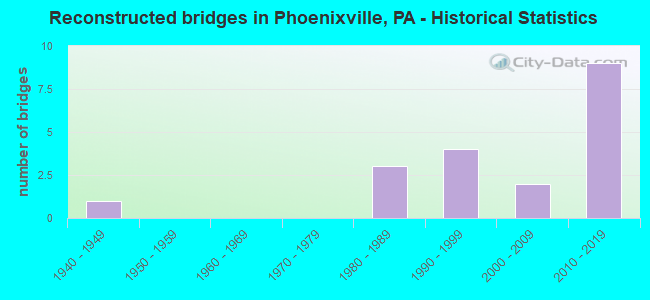
- Reconstructed bridges - Historical Statistics
- 11940-1949
- 01950-1959
- 01960-1969
- 01970-1979
- 31980-1989
- 41990-1999
- 22000-2009
- 92010-2019
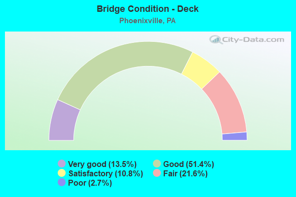
- Bridge Condition - Deck
- 13.5%Very good
- 51.4%Good
- 10.8%Satisfactory
- 21.6%Fair
- 2.7%Poor
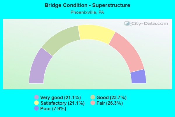
- Bridge Condition - Superstructure
- 21.1%Very good
- 23.7%Good
- 21.1%Satisfactory
- 26.3%Fair
- 7.9%Poor
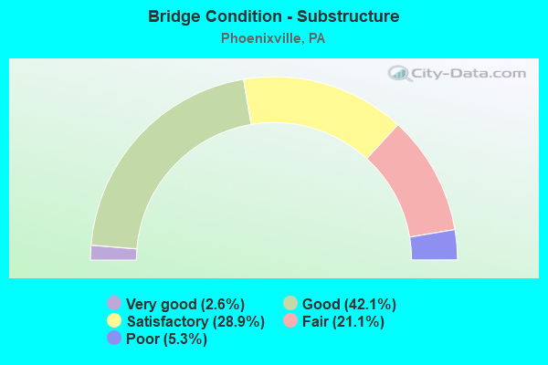
- Bridge Condition - Substructure
- 2.6%Very good
- 42.1%Good
- 28.9%Satisfactory
- 21.1%Fair
- 5.3%Poor
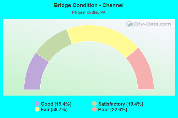
- Bridge Condition - Channel
- 19.4%Good
- 19.4%Satisfactory
- 38.7%Fair
- 22.6%Poor
Find on map >> Show street view
Structure Number: 5433, Location: Lower Swatara Twp. (Lat: 40.209922, Lng: -76.722708), Route carried "on" structure: Interstate 76, Year Built: 2016, Status: Open, Structure Length: 1.83m (6.00ft), Average Daily Traffic: 24,423 (year 2001), Truck Traffic: 24%, Average Future Daily Traffic: 31,579 (year 2030), Design Load: HL 93, Features Intersected: LR22016, SR2003
Minimum Vertical Clearance: 30+ m (98+ ft), Kilometerpoint: 403.607, Lanes on structure: 4, Lanes under structure: 2, Base Highway Network: Yes, Toll: On toll road, Owner: State Toll Authority, Approaching Roadway Width: 18.3m (60.0ft), Skew: 31 degrees, Material/Design: Prestressed concrete, Design/Construction: Box Beam or Girders - Single/Spread, Number Of Spans In Main Unit: 1, Length of Maximum Span: 17.7m (58.1ft), Curb or Sidewalk Widths: Left: 0.2m (0.7ft), Right: 0.2m (0.7ft), Curb-To-Curb Width: 18.1m (59.4ft), Out-to-Out Width: 38.5m (126.3ft)
Condition: Deck: Very good, Superstructure: Very good, Substructure: Very good, Operating Rating: 64.5 metric tons, Method Used To Determine Operating Rating: Assigned ratings based on Load and Resistance Factor Design (LRFD) reported by rating factor (RF) using HL93 loadings, Inventory Rating: 37.9 metric tons, Method Used To Determine Inventory Rating: Assigned ratings based on Load and Resistance Factor Design (LRFD) reported by rating factor (RF) using HL93 loadings, Structural Evaluation: Equal to present desirable criteria, Deck Geometry: Meets minimum limits, Underclear: Meets minimum limits, Approach Roadway Alignment: Equal to present desirable criteria, Designated Inspection Frequency: Every 24 months, Inspection Date: March 2021, Deck Structure Type: Concrete Cast-file-Place, Wearing Surface/Protective System: Wearing Surface: Monolithic Concrete, Deck Protection: Epoxy Coated Reinforcing
Find on map >> Show street view
Structure Number: 55089, Location: 1/2M Twnshp Rd. 3252-C7 (Lat: 40.144389, Lng: -75.545389), Route carried "on" structure: City street , Year Built: 2018, Status: Open, Structure Length: 1.22m (4.00ft), Average Daily Traffic: 500 (year 2018), Truck Traffic: 2%, Average Future Daily Traffic: 750 (year 2038), Design Load: HL 93, Features Intersected: Branch of French Creek, Facility Carried by Structure: Crossover Blvd.
Minimum Vertical Clearance: 30+ m (98+ ft), Kilometerpoint: 0.000, Lanes on structure: 2, Owner: Town or Township Highway Agency, Approaching Roadway Width: 11.6m (38.1ft), Material/Design: Concrete, Design/Construction: Culvert, Number Of Spans In Main Unit: 1, Length of Maximum Span: 12.2m (40.0ft)
Condition: Channel: Good, Culverts: Very good, Operating Rating: 48.6 metric tons, Method Used To Determine Operating Rating: Assigned ratings based on Load and Resistance Factor Design (LRFD) reported by rating factor (RF) using HL93 loadings, Inventory Rating: 38.9 metric tons, Method Used To Determine Inventory Rating: Assigned ratings based on Load and Resistance Factor Design (LRFD) reported by rating factor (RF) using HL93 loadings, Structural Evaluation: Equal to present desirable criteria, Waterway Adequacy: Superior to present desirable criteria, Approach Roadway Alignment: Equal to present desirable criteria, Designated Inspection Frequency: Every 24 months, Inspection Date: September 2020
Find on map >> Show street view
Structure Number: 5509, Location: 3/4 M Twnshp Line 3252-C7 (Lat: 40.144628, Lng: -75.544222), Route carried "on" structure: City street , Year Built: 2018, Status: Open, Structure Length: 0.73m (2.40ft), Average Daily Traffic: 500 (year 2018), Truck Traffic: 2%, Average Future Daily Traffic: 750 (year 2038), Design Load: HL 93, Features Intersected: Branch of French Creek, Facility Carried by Structure: Crossover Blvd.
Minimum Vertical Clearance: 30+ m (98+ ft), Kilometerpoint: 0.000, Lanes on structure: 2, Owner: Town or Township Highway Agency, Approaching Roadway Width: 11.6m (38.1ft), Skew: 1 degrees, Material/Design: Concrete, Design/Construction: Culvert, Number Of Spans In Main Unit: 1, Length of Maximum Span: 7.3m (24.0ft)
Condition: Channel: Good, Culverts: Very good, Operating Rating: 55.1 metric tons, Method Used To Determine Operating Rating: Assigned ratings based on Load and Resistance Factor Design (LRFD) reported by rating factor (RF) using HL93 loadings, Inventory Rating: 48.6 metric tons, Method Used To Determine Inventory Rating: Assigned ratings based on Load and Resistance Factor Design (LRFD) reported by rating factor (RF) using HL93 loadings, Structural Evaluation: Equal to present desirable criteria, Waterway Adequacy: Superior to present desirable criteria, Approach Roadway Alignment: Equal to present desirable criteria, Designated Inspection Frequency: Every 24 months, Inspection Date: September 2020
Find on map >> Show street view
Structure Number: 27433, Location: U PROVIDENCE 19F11/3252J3 (Lat: 40.173850, Lng: -75.506953), Route carried "under" structure: City street , Year Built: 1976, Structure Length: 0. m, Average Daily Traffic: 2,500 (year 1980), Features Intersected: OLD STATE ROAD, Facility Carried by Structure: P-TOWN X-WAY (EB)
Minimum Vertical Clearance: 5.08m (16.67ft), Kilometerpoint: 0.000, Lanes on structure: 2, Lanes under structure: 2, Material/Design: Prestressed concrete, Design/Construction: Stringer/Multi-beam, Length of Maximum Span: 27.1m (88.9ft)
Find on map >> Show street view
Structure Number: 27434, Location: U PROVIDENCE 19F11/3252J3 (Lat: 40.174103, Lng: -75.507036), Route carried "under" structure: City street , Year Built: 1976, Structure Length: 0. m, Average Daily Traffic: 2,500 (year 1980), Features Intersected: OLD STATE ROAD, Facility Carried by Structure: P-TOWN X-WAY (WB)
Minimum Vertical Clearance: 4.47m (14.67ft), Kilometerpoint: 0.000, Lanes on structure: 2, Lanes under structure: 2, Material/Design: Prestressed concrete, Design/Construction: Stringer/Multi-beam, Length of Maximum Span: 27.1m (88.9ft)
Find on map >> Show street view
Structure Number: 27435, Location: U. PROVIDENC 19G11/3253A3 (Lat: 40.169611, Lng: -75.497075), Route carried "under" structure: State highway 113, Year Built: 1976, Structure Length: 0. m, Average Daily Traffic: 11,196 (year 2022), Truck Traffic: 3%, Features Intersected: TRAPPE ROAD, Facility Carried by Structure: P-TOWN E-WAY (EB)
Minimum Vertical Clearance: 4.40m (14.44ft), Kilometerpoint: 1.497, Lanes on structure: 2, Lanes under structure: 2, Material/Design: Prestressed concrete, Design/Construction: Stringer/Multi-beam, Length of Maximum Span: 27.1m (88.9ft)
Find on map >> Show street view
Structure Number: 27436, Location: UPPER PROVIDENCE 19G11 (Lat: 40.169906, Lng: -75.497147), Route carried "under" structure: State highway 113, Year Built: 1976, Structure Length: 0. m, Average Daily Traffic: 11,196 (year 2022), Truck Traffic: 3%, Features Intersected: TRAPPE ROAD, Facility Carried by Structure: POTTSTOWN EWAY(WB)
Minimum Vertical Clearance: 4.57m (14.99ft), Kilometerpoint: 1.497, Lanes on structure: 2, Lanes under structure: 2, Material/Design: Prestressed concrete, Design/Construction: Stringer/Multi-beam, Length of Maximum Span: 27.1m (88.9ft)
Find on map >> Show street view
Structure Number: 27437, Location: COLLEGEVILLE 19K13/3253D5 (Lat: 40.161203, Lng: -75.479950), Route carried "under" structure: State highway 29, Year Built: 1976, Structure Length: 0. m, Average Daily Traffic: 11,828 (year 2022), Truck Traffic: 2%, Features Intersected: PA 29 COLLEGEVILLE ROAD, Facility Carried by Structure: P-TOWN X-WAY (EB)
Minimum Vertical Clearance: 4.67m (15.32ft), Kilometerpoint: 3.137, Lanes on structure: 3, Lanes under structure: 4, Material/Design: Steel, Design/Construction: Stringer/Multi-beam, Length of Maximum Span: 39.3m (128.9ft)
Find on map >> Show street view
Structure Number: 27437, Location: COLLEGEVILLE 19K13/3253D5 (Lat: 40.161203, Lng: -75.479950), Route carried "under" structure: State highway 29, Year Built: 1976, Structure Length: 0. m, Average Daily Traffic: 10,792 (year 2022), Truck Traffic: 2%, Features Intersected: PA 29 COLLEGEVILLE ROAD, Facility Carried by Structure: P-TOWN X-WAY (EB)
Minimum Vertical Clearance: 4.62m (15.16ft), Kilometerpoint: 3.137, Lanes on structure: 3, Lanes under structure: 3, Material/Design: Steel, Design/Construction: Stringer/Multi-beam, Length of Maximum Span: 39.3m (128.9ft)
Find on map >> Show street view
Structure Number: 27438, Location: COLLEGEVILLE 19K13/3253D5 (Lat: 40.161394, Lng: -75.479878), Route carried "under" structure: State highway 29, Year Built: 1976, Structure Length: 0. m, Average Daily Traffic: 11,828 (year 2022), Truck Traffic: 2%, Features Intersected: COLLEGEVILLE ROAD, Facility Carried by Structure: P-TOWN X-WAY (WB)
Minimum Vertical Clearance: 5.11m (16.77ft), Kilometerpoint: 3.137, Lanes on structure: 2, Lanes under structure: 4, Material/Design: Steel, Design/Construction: Stringer/Multi-beam, Length of Maximum Span: 39.0m (128.0ft)
Find on map >> Show street view
Structure Number: 27438, Location: COLLEGEVILLE 19K13/3253D5 (Lat: 40.161394, Lng: -75.479878), Route carried "under" structure: State highway 29, Year Built: 1976, Structure Length: 0. m, Average Daily Traffic: 10,792 (year 2022), Truck Traffic: 2%, Features Intersected: COLLEGEVILLE ROAD, Facility Carried by Structure: P-TOWN X-WAY (WB)
Minimum Vertical Clearance: 5.16m (16.93ft), Kilometerpoint: 3.137, Lanes on structure: 2, Lanes under structure: 3, Material/Design: Steel, Design/Construction: Stringer/Multi-beam, Length of Maximum Span: 39.0m (128.0ft)