Bridge Statistics for Plymouth Township, Michigan (MI)
Condition, Traffic, Stress, Structural Evaluation, Project Costs
- National Bridge Inventory (NBI) Statistics
- 75Number of bridges
- 892ft / 272mTotal length
- $3,208,000Total costs
- 3,663,019Total average daily traffic
- 239,897Total average daily truck traffic
- National Bridge Inventory (NBI) Registered Bridges for Plymouth Township
- No street view available for this location
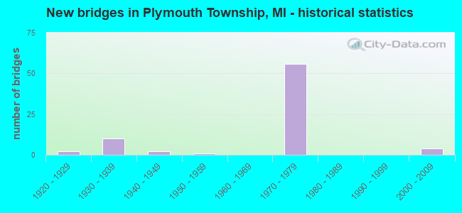
- New bridges - historical statistics
- 21920-1929
- 101930-1939
- 21940-1949
- 11950-1959
- 561970-1979
- 42000-2009
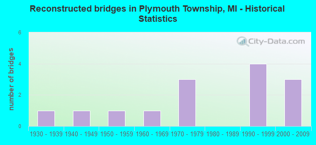
- Reconstructed bridges - Historical Statistics
- 11930-1939
- 11940-1949
- 11950-1959
- 11960-1969
- 31970-1979
- 01980-1989
- 41990-1999
- 32000-2009
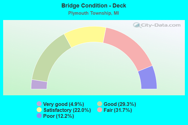
- Bridge Condition - Deck
- 4.9%Very good
- 29.3%Good
- 22.0%Satisfactory
- 31.7%Fair
- 12.2%Poor
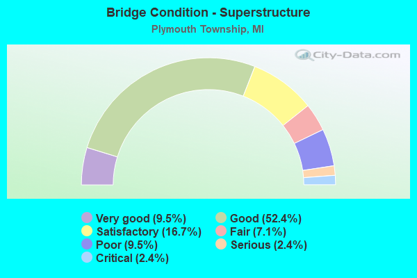
- Bridge Condition - Superstructure
- 9.5%Very good
- 52.4%Good
- 16.7%Satisfactory
- 7.1%Fair
- 9.5%Poor
- 2.4%Serious
- 2.4%Critical
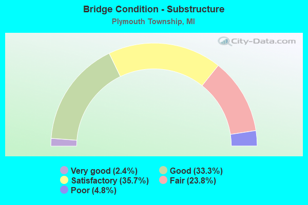
- Bridge Condition - Substructure
- 2.4%Very good
- 33.3%Good
- 35.7%Satisfactory
- 23.8%Fair
- 4.8%Poor
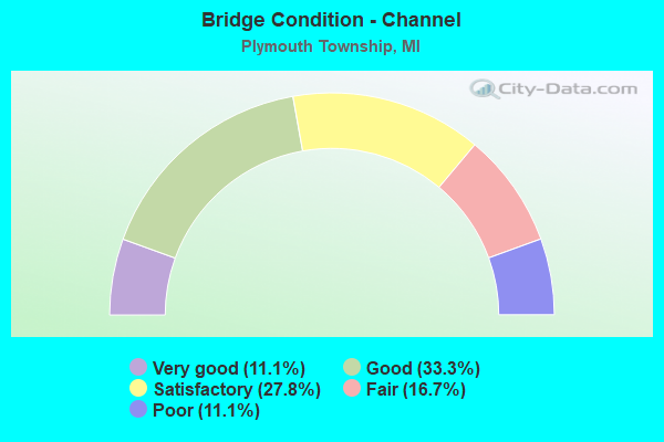
- Bridge Condition - Channel
- 11.1%Very good
- 33.3%Good
- 27.8%Satisfactory
- 16.7%Fair
- 11.1%Poor
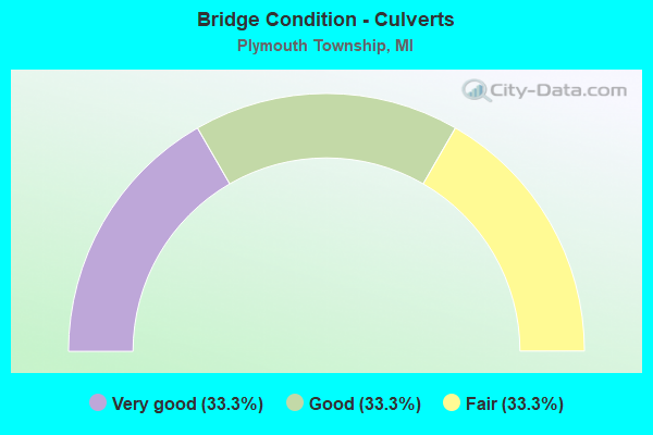
- Bridge Condition - Culverts
- 33.3%Very good
- 33.3%Good
- 33.3%Fair
Find on map >> Show street view
Structure Number: 11343, Location: 0.3 MI E OF WASHTENAW COL (Lat: 42.349728, Lng: -83.540353), Route carried "on" structure: State highway 14, Year Built: 2003, Status: Open, Structure Length: 0.91m (2.99ft), Average Daily Traffic: 19,471 (year 2007), Truck Traffic: 1%, Average Future Daily Traffic: 28,604 (year 2018), Design Load: HS 25 or greater, Features Intersected: FELLOWS CREEK
Minimum Vertical Clearance: 30.48m (100.00ft), Kilometerpoint: 0.595, Lanes on structure: 2, Base Highway Network: Yes (Inventory Route: 160, Subroute: 2), Owner: State Highway Agency, Approaching Roadway Width: 13.4m (44.0ft), Material/Design: Concrete, Design/Construction: Culvert, Number Of Spans In Main Unit: 1, Length of Maximum Span: 8.5m (27.9ft), Curb-To-Curb Width: 14.6m (47.9ft), Out-to-Out Width: 15.6m (51.2ft)
Condition: Channel: Good, Culverts: Very good, Operating Rating: 60.3 metric tons, Method Used To Determine Operating Rating: Load Factor (LF) rating reported by rating factor (RF) method using MS18 loading, Inventory Rating: 36.0 metric tons, Method Used To Determine Inventory Rating: Load Factor (LF) rating reported by rating factor (RF) method using MS18 loading, Structural Evaluation: Equal to present desirable criteria, Deck Geometry: Superior to present desirable criteria, Waterway Adequacy: Equal to present minimum criteria, Approach Roadway Alignment: Equal to present desirable criteria, Designated Inspection Frequency: Every 24 months, Inspection Date: October 2021, Wearing Surface/Protective System: Wearing Surface: Bituminous
Find on map >> Show street view
Structure Number: 11344, Location: 2.7 MI E OF WASHTENAW COL (Lat: 42.357914, Lng: -83.501189), Route carried "on" structure: State highway 14, Year Built: 2003, Status: Open, Structure Length: 1.16m (3.81ft), Average Daily Traffic: 13,944 (year 2007), Truck Traffic: 2%, Average Future Daily Traffic: 18,894 (year 2018), Design Load: HS 25 or greater, Features Intersected: WILLOW CREEK
Minimum Vertical Clearance: 30.48m (100.00ft), Kilometerpoint: 4.104, Lanes on structure: 2, Base Highway Network: Yes (Inventory Route: 160, Subroute: 2), Owner: State Highway Agency, Approaching Roadway Width: 13.4m (44.0ft), Skew: 4 degrees, Material/Design: Concrete, Design/Construction: Culvert, Number Of Spans In Main Unit: 1, Length of Maximum Span: 10.4m (34.1ft), Curb-To-Curb Width: 13.4m (44.0ft), Out-to-Out Width: 14.4m (47.2ft)
Condition: Channel: Satisfactory, Culverts: Good, Operating Rating: 67.6 metric tons, Method Used To Determine Operating Rating: Field evaluation and documented engineering judgment, Inventory Rating: 40.5 metric tons, Method Used To Determine Inventory Rating: Field evaluation and documented engineering judgment, Structural Evaluation: Better than present minimum criteria, Deck Geometry: Equal to present minimum criteria, Waterway Adequacy: Equal to present minimum criteria, Approach Roadway Alignment: Equal to present desirable criteria, Designated Inspection Frequency: Every 24 months, Inspection Date: October 2021, Deck Structure Type: Concrete Cast-file-Place, Wearing Surface/Protective System: Wearing Surface: Bituminous
Find on map >> Show street view
Structure Number: 1135, Location: 0.3 MI WEST OF PLYMOUTH (Lat: 42.390619, Lng: -83.466747), Route carried "on" structure: State highway 14, Year Built: 1976, Status: Open, Structure Length: 3.58m (11.75ft), Average Daily Traffic: 93,826 (year 2007), Truck Traffic: 7%, Average Future Daily Traffic: 110,000 (year 2026), Design Load: HS 25 or greater, Features Intersected: ROUGE RIVER
Minimum Vertical Clearance: 30.48m (100.00ft), Kilometerpoint: 7.683, Lanes on structure: 6, Base Highway Network: Yes (Inventory Route: 160, Subroute: 5), Owner: State Highway Agency, Approaching Roadway Width: 37.8m (124.0ft), Skew: 30 degrees, Material/Design: Steel, Design/Construction: Stringer/Multi-beam, Number Of Spans In Main Unit: 1, Length of Maximum Span: 35.8m (117.5ft), Curb or Sidewalk Widths: Left: 0.5m (1.6ft), Right: 0.5m (1.6ft), Curb-To-Curb Width: 35.7m (117.1ft), Out-to-Out Width: 40.4m (132.5ft)
Condition: Deck: Satisfactory, Superstructure: Good, Substructure: Good, Channel: Very good, Operating Rating: 79.4 metric tons, Method Used To Determine Operating Rating: Load Factor (LF) rating reported by rating factor (RF) method using MS18 loading, Inventory Rating: 47.6 metric tons, Method Used To Determine Inventory Rating: Load Factor (LF) rating reported by rating factor (RF) method using MS18 loading, Structural Evaluation: Better than present minimum criteria, Deck Geometry: Superior to present desirable criteria, Waterway Adequacy: Equal to present desirable criteria, Approach Roadway Alignment: Equal to present desirable criteria, Designated Inspection Frequency: Every 24 months, Inspection Date: October 2021, Deck Structure Type: Concrete Cast-file-Place, Wearing Surface/Protective System: Wearing Surface: Latex Concrete, Deck Protection: Epoxy Coated Reinforcing
Find on map >> Show street view
Structure Number: 11352, Location: 1.5 MI W OF PLYMOUTH (Lat: 42.383208, Lng: -83.488114), Route carried "on" structure: State highway 14, Year Built: 1976, Year Reconstructed: 2006, Status: Open, Structure Length: 8.75m (28.71ft), Average Daily Traffic: 36,640 (year 2007), Truck Traffic: 8%, Average Future Daily Traffic: 95,000 (year 2026), Design Load: HS 25 or greater, Features Intersected: CSX RR
Minimum Vertical Clearance: 30.48m (100.00ft), Kilometerpoint: 5.623, Lanes on structure: 3, Base Highway Network: Yes (Inventory Route: 160, Subroute: 4), Owner: State Highway Agency, Approaching Roadway Width: 18.2m (59.7ft), Skew: 5 degrees, Material/Design: Steel, Design/Construction: Stringer/Multi-beam, Number Of Spans In Main Unit: 3, Length of Maximum Span: 38.4m (126.0ft), Curb-To-Curb Width: 18.4m (60.4ft), Out-to-Out Width: 19.4m (63.6ft)
Condition: Deck: Fair, Superstructure: Good, Substructure: Fair, Operating Rating: 79.4 metric tons, Method Used To Determine Operating Rating: Load Factor (LF) rating reported by rating factor (RF) method using MS18 loading, Inventory Rating: 47.6 metric tons, Method Used To Determine Inventory Rating: Load Factor (LF) rating reported by rating factor (RF) method using MS18 loading, Structural Evaluation: Somewhat better than minimum adequacy, Deck Geometry: Equal to present desirable criteria, Approach Roadway Alignment: Equal to present desirable criteria, Designated Inspection Frequency: Every 24 months, Inspection Date: October 2021, Deck Structure Type: Concrete Cast-file-Place, Wearing Surface/Protective System: Wearing Surface: Latex Concrete, Deck Protection: Epoxy Coated Reinforcing
Find on map >> Show street view
Structure Number: 11356, Location: 2.5 MI W OF PLYMOUTH (Lat: 42.375533, Lng: -83.534303), Route carried "on" structure: County highway 2057, Year Built: 1976, Status: Open, Structure Length: 11.02m (36.15ft), Average Daily Traffic: 65,500 (year 2006), Truck Traffic: 10%, Average Future Daily Traffic: 80,000 (year 2026), Design Load: HS 20, Features Intersected: M-14, Facility Carried by Structure: N TERRITORIAL RD
Minimum Vertical Clearance: 30.48m (100.00ft), Kilometerpoint: 1.194, Lanes on structure: 2, Lanes under structure: 4, Owner: State Highway Agency, Approaching Roadway Width: 12.8m (42.0ft), Skew: 3 degrees, Material/Design: Steel, Design/Construction: Stringer/Multi-beam, Number Of Spans In Main Unit: 4, Length of Maximum Span: 41.4m (135.8ft), Curb-To-Curb Width: 13.6m (44.6ft), Out-to-Out Width: 14.8m (48.6ft)
Condition: Deck: Good, Superstructure: Good, Substructure: Good, Operating Rating: 85.5 metric tons, Method Used To Determine Operating Rating: Load Factor (LF) rating reported by rating factor (RF) method using MS18 loading, Inventory Rating: 51.2 metric tons, Method Used To Determine Inventory Rating: Load Factor (LF) rating reported by rating factor (RF) method using MS18 loading, Structural Evaluation: Better than present minimum criteria, Deck Geometry: Superior to present desirable criteria, Underclear: Somewhat better than minimum adequacy, Approach Roadway Alignment: Equal to present desirable criteria, Designated Inspection Frequency: Every 24 months, Inspection Date: October 2021, Deck Structure Type: Concrete Cast-file-Place, Wearing Surface/Protective System: Wearing Surface: Monolithic Concrete, Deck Protection: Epoxy Coated Reinforcing
Find on map >> Show street view
Structure Number: 11357, Location: 2.0 MI W OF PLYMOUTH (Lat: 42.380256, Lng: -83.529214), Route carried "on" structure: County highway , Year Built: 1976, Status: Open, Structure Length: 10.58m (34.71ft), Average Daily Traffic: 65,500 (year 2006), Truck Traffic: 10%, Average Future Daily Traffic: 80,000 (year 2026), Design Load: HS 20, Features Intersected: M-14, Facility Carried by Structure: RIDGE ROAD
Minimum Vertical Clearance: 30.48m (100.00ft), Kilometerpoint: 8.453, Lanes on structure: 2, Lanes under structure: 4, Owner: State Highway Agency, Approaching Roadway Width: 12.8m (42.0ft), Skew: 3 degrees, Material/Design: Steel, Design/Construction: Stringer/Multi-beam, Number Of Spans In Main Unit: 4, Length of Maximum Span: 38.0m (124.7ft), Curb-To-Curb Width: 13.6m (44.6ft), Out-to-Out Width: 14.8m (48.6ft)
Condition: Deck: Good, Superstructure: Good, Substructure: Good, Operating Rating: 79.4 metric tons, Method Used To Determine Operating Rating: Load Factor (LF) rating reported by rating factor (RF) method using MS18 loading, Inventory Rating: 44.7 metric tons, Method Used To Determine Inventory Rating: Load Factor (LF) rating reported by rating factor (RF) method using MS18 loading, Structural Evaluation: Better than present minimum criteria, Deck Geometry: Superior to present desirable criteria, Underclear: Superior to present desirable criteria, Approach Roadway Alignment: Equal to present desirable criteria, Designated Inspection Frequency: Every 24 months, Inspection Date: October 2021, Deck Structure Type: Concrete Cast-file-Place, Wearing Surface/Protective System: Wearing Surface: Monolithic Concrete, Deck Protection: Epoxy Coated Reinforcing
Find on map >> Show street view
Structure Number: 11358, Location: 1.0 MI W. OF PLYMOUTH (Lat: 42.382461, Lng: -83.510083), Route carried "on" structure: County highway 2057, Year Built: 1976, Status: Open, Structure Length: 8.41m (27.59ft), Average Daily Traffic: 65,500 (year 2006), Truck Traffic: 10%, Average Future Daily Traffic: 80,000 (year 2026), Design Load: HS 20, Features Intersected: M-14, Facility Carried by Structure: BECK ROAD
Minimum Vertical Clearance: 30.48m (100.00ft), Kilometerpoint: 12.766, Lanes on structure: 6, Lanes under structure: 8, Owner: State Highway Agency, Approaching Roadway Width: 31.7m (104.0ft), Material/Design: Steel, Design/Construction: Stringer/Multi-beam, Number Of Spans In Main Unit: 2, Length of Maximum Span: 43.0m (141.1ft), Curb or Sidewalk Widths: Left: 0.6m (2.0ft), Right: 0.6m (2.0ft), Curb-To-Curb Width: 27.3m (89.6ft), Out-to-Out Width: 28.5m (93.5ft)
Condition: Deck: Fair, Superstructure: Satisfactory, Substructure: Satisfactory, Operating Rating: 86.5 metric tons, Method Used To Determine Operating Rating: Load Factor (LF) rating reported by rating factor (RF) method using MS18 loading, Inventory Rating: 44.1 metric tons, Method Used To Determine Inventory Rating: Load Factor (LF) rating reported by rating factor (RF) method using MS18 loading, Structural Evaluation: Equal to present minimum criteria, Deck Geometry: Better than present minimum criteria, Underclear: Better than present minimum criteria, Approach Roadway Alignment: Equal to present desirable criteria, Designated Inspection Frequency: Every 24 months, Inspection Date: October 2021, Deck Structure Type: Concrete Cast-file-Place, Wearing Surface/Protective System: Wearing Surface: Monolithic Concrete, Deck Protection: Epoxy Coated Reinforcing
Find on map >> Show street view
Structure Number: 11359, Location: 1.2 MI W OF PLYMOUTH (Lat: 42.383542, Lng: -83.480669), Route carried "on" structure: State highway 14, Year Built: 1976, Status: Open, Structure Length: 7.68m (25.20ft), Average Daily Traffic: 46,913 (year 2007), Truck Traffic: 8%, Average Future Daily Traffic: 80,000 (year 2026), Design Load: HS 25 or greater, Features Intersected: SHELDON ROAD
Minimum Vertical Clearance: 30.48m (100.00ft), Kilometerpoint: 6.238, Lanes on structure: 4, Lanes under structure: 6, Base Highway Network: Yes (Inventory Route: 160, Subroute: 4), Owner: State Highway Agency, Approaching Roadway Width: 20.1m (65.9ft), Material/Design: Steel, Design/Construction: Stringer/Multi-beam, Number Of Spans In Main Unit: 4, Length of Maximum Span: 31.7m (104.0ft), Curb or Sidewalk Widths: Left: 0.4m (1.3ft), Right: 0.4m (1.3ft), Curb-To-Curb Width: 21.0m (68.9ft), Out-to-Out Width: 21.9m (71.9ft)
Condition: Deck: Good, Superstructure: Good, Substructure: Satisfactory, Operating Rating: 82.0 metric tons, Method Used To Determine Operating Rating: Load Factor (LF) rating reported by rating factor (RF) method using MS18 loading, Inventory Rating: 49.2 metric tons, Method Used To Determine Inventory Rating: Load Factor (LF) rating reported by rating factor (RF) method using MS18 loading, Structural Evaluation: Equal to present minimum criteria, Deck Geometry: Superior to present desirable criteria, Underclear: Superior to present desirable criteria, Approach Roadway Alignment: Equal to present desirable criteria, Designated Inspection Frequency: Every 24 months, Other Special Inspection Frequency: Every 6 months, Inspection Date: October 2021, Other Special Inspection Date: October 2021, Deck Structure Type: Concrete Cast-file-Place, Wearing Surface/Protective System: Wearing Surface: Latex Concrete, Deck Protection: Epoxy Coated Reinforcing
Find on map >> Show street view
Structure Number: 11361, Location: 0.4 MI WEST OF PLYMOUTH (Lat: 42.390250, Lng: -83.468569), Route carried "on" structure: State highway 14, Year Built: 1976, Status: Open, Structure Length: 3.93m (12.89ft), Average Daily Traffic: 90,300 (year 2013), Truck Traffic: 4%, Average Future Daily Traffic: 103,845 (year 2033), Design Load: HS 25 or greater, Features Intersected: EDWARD HINES DRIVE
Minimum Vertical Clearance: 30.48m (100.00ft), Kilometerpoint: 7.529, Lanes on structure: 6, Lanes under structure: 2, Base Highway Network: Yes (Inventory Route: 160, Subroute: 5), Owner: State Highway Agency, Approaching Roadway Width: 37.8m (124.0ft), Skew: 30 degrees, Material/Design: Steel, Design/Construction: Stringer/Multi-beam, Number Of Spans In Main Unit: 1, Length of Maximum Span: 39.3m (128.9ft), Curb-To-Curb Width: 35.7m (117.1ft), Out-to-Out Width: 37.7m (123.7ft)
Condition: Deck: Satisfactory, Superstructure: Good, Substructure: Satisfactory, Operating Rating: 93.6 metric tons, Method Used To Determine Operating Rating: Load Factor (LF) rating reported by rating factor (RF) method using MS18 loading, Inventory Rating: 56.1 metric tons, Method Used To Determine Inventory Rating: Load Factor (LF) rating reported by rating factor (RF) method using MS18 loading, Structural Evaluation: Equal to present minimum criteria, Deck Geometry: Superior to present desirable criteria, Underclear: Equal to present minimum criteria, Approach Roadway Alignment: Equal to present desirable criteria, Designated Inspection Frequency: Every 24 months, Inspection Date: October 2021, Deck Structure Type: Concrete Cast-file-Place, Wearing Surface/Protective System: Wearing Surface: Epoxy Overlay, Deck Protection: Epoxy Coated Reinforcing
Find on map >> Show street view
Structure Number: 11362, Location: 0.2 MI W OF PLYMOUTH (Lat: 42.390856, Lng: -83.465553), Route carried "on" structure: County highway 2057, Year Built: 1976, Status: Open, Structure Length: 6.34m (20.80ft), Average Daily Traffic: 92,000 (year 2006), Truck Traffic: 7%, Average Future Daily Traffic: 110,000 (year 2026), Design Load: HS 20, Features Intersected: M-14, Facility Carried by Structure: NORTHVILLE RD
Minimum Vertical Clearance: 30.48m (100.00ft), Kilometerpoint: 0.826, Lanes on structure: 4, Lanes under structure: 6, Base Highway Network: Yes (Inventory Route: 167, Subroute: 2), Owner: State Highway Agency, Approaching Roadway Width: 18.2m (59.7ft), Skew: 1 degrees, Material/Design: Steel, Design/Construction: Stringer/Multi-beam, Number Of Spans In Main Unit: 4, Length of Maximum Span: 23.3m (76.4ft), Curb or Sidewalk Widths: Left: 1.8m (5.9ft), Right: 1.8m (5.9ft), Curb-To-Curb Width: 19.5m (64.0ft), Out-to-Out Width: 23.9m (78.4ft)
Condition: Deck: Satisfactory, Superstructure: Good, Substructure: Satisfactory, Operating Rating: 65.8 metric tons, Method Used To Determine Operating Rating: Load Factor (LF) rating reported by rating factor (RF) method using MS18 loading, Inventory Rating: 39.2 metric tons, Method Used To Determine Inventory Rating: Load Factor (LF) rating reported by rating factor (RF) method using MS18 loading, Structural Evaluation: Equal to present minimum criteria, Deck Geometry: Better than present minimum criteria, Underclear: Better than present minimum criteria, Approach Roadway Alignment: Equal to present desirable criteria, Designated Inspection Frequency: Every 24 months, Inspection Date: October 2021, Deck Structure Type: Concrete Cast-file-Place, Wearing Surface/Protective System: Wearing Surface: Latex Concrete, Deck Protection: Epoxy Coated Reinforcing
Find on map >> Show street view
Structure Number: 11363, Location: 0.3 MI NORTH OF PLYMOUTH (Lat: 42.389614, Lng: -83.455664), Route carried "on" structure: County highway , Year Built: 1976, Status: Open, Structure Length: 5.52m (18.11ft), Average Daily Traffic: 92,000 (year 2006), Truck Traffic: 8%, Average Future Daily Traffic: 110,000 (year 2026), Design Load: HS 20, Features Intersected: M-14, Facility Carried by Structure: ROBINWOOD DRIVE
Minimum Vertical Clearance: 30.48m (100.00ft), Kilometerpoint: 0.336, Lanes on structure: 2, Lanes under structure: 6, Owner: State Highway Agency, Approaching Roadway Width: 12.8m (42.0ft), Skew: 1 degrees, Material/Design: Steel, Design/Construction: Stringer/Multi-beam, Number Of Spans In Main Unit: 2, Length of Maximum Span: 28.0m (91.9ft), Curb or Sidewalk Widths: Left: 1.8m (5.9ft), Right: 1.8m (5.9ft), Curb-To-Curb Width: 8.5m (27.9ft), Out-to-Out Width: 12.9m (42.3ft)
Condition: Deck: Good, Superstructure: Good, Substructure: Good, Operating Rating: 67.4 metric tons, Method Used To Determine Operating Rating: Load Factor (LF) rating reported by rating factor (RF) method using MS18 loading, Inventory Rating: 40.2 metric tons, Method Used To Determine Inventory Rating: Load Factor (LF) rating reported by rating factor (RF) method using MS18 loading, Structural Evaluation: Better than present minimum criteria, Deck Geometry: High priority of replacement, Underclear: Better than present minimum criteria, Approach Roadway Alignment: Equal to present desirable criteria, Designated Inspection Frequency: Every 24 months, Inspection Date: October 2021, Deck Structure Type: Concrete Cast-file-Place, Wearing Surface/Protective System: Wearing Surface: Monolithic Concrete
Find on map >> Show street view
Structure Number: 11364, Location: 1 MI W OF W CTY LTS LIVON (Lat: 42.386819, Lng: -83.448869), Route carried "on" structure: County highway 2057, Year Built: 1977, Status: Open, Structure Length: 8.81m (28.90ft), Average Daily Traffic: 92,000 (year 2006), Truck Traffic: 7%, Average Future Daily Traffic: 110,000 (year 2026), Design Load: HS 20, Features Intersected: M-14, Facility Carried by Structure: SCHOOLCRAFT CONN
Minimum Vertical Clearance: 30.48m (100.00ft), Kilometerpoint: 1.494, Lanes on structure: 4, Lanes under structure: 6, Owner: State Highway Agency, Approaching Roadway Width: 18.2m (59.7ft), Skew: 5 degrees, Material/Design: Steel, Design/Construction: Stringer/Multi-beam, Number Of Spans In Main Unit: 2, Length of Maximum Span: 45.4m (149.0ft), Curb or Sidewalk Widths: Left: 1.8m (5.9ft), Right: 1.8m (5.9ft), Curb-To-Curb Width: 14.6m (47.9ft), Out-to-Out Width: 20.1m (65.9ft)
Condition: Deck: Fair, Superstructure: Good, Substructure: Satisfactory, Operating Rating: 77.1 metric tons, Method Used To Determine Operating Rating: Load Factor (LF) rating reported by rating factor (RF) method using MS18 loading, Inventory Rating: 46.0 metric tons, Method Used To Determine Inventory Rating: Load Factor (LF) rating reported by rating factor (RF) method using MS18 loading, Structural Evaluation: Equal to present minimum criteria, Deck Geometry: High priority of replacement, Underclear: Equal to present minimum criteria, Approach Roadway Alignment: Equal to present desirable criteria, Designated Inspection Frequency: Every 24 months, Inspection Date: October 2021, Deck Structure Type: Concrete Cast-file-Place, Wearing Surface/Protective System: Wearing Surface: Monolithic Concrete, Deck Protection: Epoxy Coated Reinforcing
Find on map >> Show street view
Structure Number: 11365, Location: 1.2 MI W OF PLYMOUTH (Lat: 42.383247, Lng: -83.480700), Route carried "on" structure: State highway 14, Year Built: 1976, Status: Open, Structure Length: 7.93m (26.02ft), Average Daily Traffic: 46,913 (year 2007), Truck Traffic: 7%, Average Future Daily Traffic: 110,000 (year 2026), Design Load: HS 25 or greater, Features Intersected: SHELDON ROAD
Minimum Vertical Clearance: 30.48m (100.00ft), Kilometerpoint: 6.233, Lanes on structure: 4, Lanes under structure: 6, Base Highway Network: Yes (Inventory Route: 160, Subroute: 5), Owner: State Highway Agency, Approaching Roadway Width: 20.1m (65.9ft), Skew: 1 degrees, Material/Design: Steel, Design/Construction: Stringer/Multi-beam, Number Of Spans In Main Unit: 4, Length of Maximum Span: 27.8m (91.2ft), Curb or Sidewalk Widths: Left: 0.4m (1.3ft), Right: 0.4m (1.3ft), Curb-To-Curb Width: 21.0m (68.9ft), Out-to-Out Width: 21.9m (71.9ft)
Condition: Deck: Good, Superstructure: Good, Substructure: Fair, Operating Rating: 67.7 metric tons, Method Used To Determine Operating Rating: Load Factor (LF) rating reported by rating factor (RF) method using MS18 loading, Inventory Rating: 40.5 metric tons, Method Used To Determine Inventory Rating: Load Factor (LF) rating reported by rating factor (RF) method using MS18 loading, Structural Evaluation: Somewhat better than minimum adequacy, Deck Geometry: Superior to present desirable criteria, Underclear: Equal to present desirable criteria, Approach Roadway Alignment: Equal to present desirable criteria, Designated Inspection Frequency: Every 24 months, Inspection Date: October 2021, Deck Structure Type: Concrete Cast-file-Place, Wearing Surface/Protective System: Wearing Surface: Latex Concrete, Deck Protection: Epoxy Coated Reinforcing
Find on map >> Show street view
Structure Number: 11955, Location: 0.3 MI W OF LIVONIA LTS (Lat: 42.371744, Lng: -83.436592), Route carried "on" structure: Interstate 275, Year Built: 1972, Year Reconstructed: 2012, Status: Open, Structure Length: 5.18m (16.99ft), Average Daily Traffic: 65,653 (year 2007), Truck Traffic: 6%, Average Future Daily Traffic: 70,250 (year 2042), Design Load: HS 20+Mod, Features Intersected: MIDDLE ROUGE RIVER
Minimum Vertical Clearance: 30.48m (100.00ft), Kilometerpoint: 33.395, Lanes on structure: 3, Base Highway Network: Yes (Inventory Route: 160, Subroute: 10), Owner: State Highway Agency, Approaching Roadway Width: 15.2m (49.9ft), Skew: 2 degrees, Material/Design: Steel, Design/Construction: Stringer/Multi-beam, Number Of Spans In Main Unit: 2, Length of Maximum Span: 27.1m (88.9ft), Curb-To-Curb Width: 16.0m (52.5ft), Out-to-Out Width: 17.0m (55.8ft)
Condition: Deck: Good, Superstructure: Good, Substructure: Good, Channel: Good, Operating Rating: 78.4 metric tons, Method Used To Determine Operating Rating: Load Factor (LF) rating reported by rating factor (RF) method using MS18 loading, Inventory Rating: 47.0 metric tons, Method Used To Determine Inventory Rating: Load Factor (LF) rating reported by rating factor (RF) method using MS18 loading, Structural Evaluation: Better than present minimum criteria, Deck Geometry: Equal to present minimum criteria, Waterway Adequacy: Equal to present desirable criteria, Approach Roadway Alignment: Equal to present desirable criteria, Designated Inspection Frequency: Every 24 months, Inspection Date: October 2020, Deck Structure Type: Concrete Cast-file-Place, Wearing Surface/Protective System: Wearing Surface: Latex Concrete
Find on map >> Show street view
Structure Number: 11956, Location: 0.3 MI W OF LIVONIA LTS (Lat: 42.371650, Lng: -83.436200), Route carried "on" structure: Interstate 275, Year Built: 1972, Status: Open, Structure Length: 5.18m (16.99ft), Average Daily Traffic: 65,653 (year 2007), Truck Traffic: 6%, Average Future Daily Traffic: 76,050 (year 2042), Design Load: HS 20+Mod, Features Intersected: MIDDLE ROUGE RIVER
Minimum Vertical Clearance: 30.48m (100.00ft), Kilometerpoint: 33.371, Lanes on structure: 3, Base Highway Network: Yes (Inventory Route: 160, Subroute: 8), Owner: State Highway Agency, Approaching Roadway Width: 15.2m (49.9ft), Skew: 2 degrees, Material/Design: Steel, Design/Construction: Stringer/Multi-beam, Number Of Spans In Main Unit: 2, Length of Maximum Span: 27.1m (88.9ft), Curb-To-Curb Width: 16.0m (52.5ft), Out-to-Out Width: 17.0m (55.8ft)
Condition: Deck: Good, Superstructure: Good, Substructure: Good, Channel: Good, Operating Rating: 78.4 metric tons, Method Used To Determine Operating Rating: Load Factor (LF) rating reported by rating factor (RF) method using MS18 loading, Inventory Rating: 47.0 metric tons, Method Used To Determine Inventory Rating: Load Factor (LF) rating reported by rating factor (RF) method using MS18 loading, Structural Evaluation: Better than present minimum criteria, Deck Geometry: Equal to present minimum criteria, Waterway Adequacy: Equal to present desirable criteria, Approach Roadway Alignment: Equal to present desirable criteria, Designated Inspection Frequency: Every 24 months, Inspection Date: October 2020, Deck Structure Type: Concrete Cast-file-Place, Wearing Surface/Protective System: Wearing Surface: Latex Concrete
Find on map >> Show street view
Structure Number: 11962, Location: S OF SCHOOLCRAFT (Lat: 42.380969, Lng: -83.436675), Route carried "on" structure: Interstate 275, Year Built: 1971, Status: Open, Structure Length: 9.02m (29.59ft), Average Daily Traffic: 65,653 (year 2007), Truck Traffic: 6%, Average Future Daily Traffic: 74,210 (year 2018), Design Load: HS 20, Features Intersected: CSX RR
Minimum Vertical Clearance: 30+ m (98+ ft), Kilometerpoint: 34.423, Lanes on structure: 3, Base Highway Network: Yes (Inventory Route: 160, Subroute: 8), Owner: State Highway Agency, Approaching Roadway Width: 20.4m (66.9ft), Skew: 9 degrees, Material/Design: Steel, Design/Construction: Stringer/Multi-beam, Number Of Spans In Main Unit: 4, Length of Maximum Span: 29.8m (97.8ft), Curb-To-Curb Width: 16.4m (53.8ft), Out-to-Out Width: 17.3m (56.8ft)
Condition: Deck: Fair, Superstructure: Good, Substructure: Fair, Operating Rating: 67.7 metric tons, Method Used To Determine Operating Rating: Load Factor (LF) rating reported by rating factor (RF) method using MS18 loading, Inventory Rating: 40.5 metric tons, Method Used To Determine Inventory Rating: Load Factor (LF) rating reported by rating factor (RF) method using MS18 loading, Structural Evaluation: Somewhat better than minimum adequacy, Deck Geometry: Equal to present minimum criteria, Approach Roadway Alignment: Equal to present desirable criteria, Designated Inspection Frequency: Every 24 months, Inspection Date: October 2020, Deck Structure Type: Concrete Cast-file-Place, Wearing Surface/Protective System: Wearing Surface: Latex Concrete
Find on map >> Show street view
Structure Number: 11963, Location: S OF SCHOOLCRAFT (Lat: 42.380764, Lng: -83.436361), Route carried "on" structure: Ramp Interstate 275, Year Built: 1971, Year Reconstructed: 2001, Status: Open, Structure Length: 9.84m (32.28ft), Average Daily Traffic: 8,760 (year 1982), Average Future Daily Traffic: 8,760 (year 1977), Design Load: HS 20, Features Intersected: CSX RR
Minimum Vertical Clearance: 30+ m (98+ ft), Kilometerpoint: 0.291, Lanes on structure: 1, Owner: State Highway Agency, Approaching Roadway Width: 10.0m (32.8ft), Skew: 9 degrees, Material/Design: Steel, Design/Construction: Stringer/Multi-beam, Number Of Spans In Main Unit: 5, Length of Maximum Span: 23.7m (77.8ft), Curb-To-Curb Width: 8.7m (28.5ft), Out-to-Out Width: 9.8m (32.2ft)
Condition: Deck: Good, Superstructure: Good, Substructure: Good, Operating Rating: 64.5 metric tons, Method Used To Determine Operating Rating: Load Factor (LF) rating reported by rating factor (RF) method using MS18 loading, Inventory Rating: 38.6 metric tons, Method Used To Determine Inventory Rating: Load Factor (LF) rating reported by rating factor (RF) method using MS18 loading, Structural Evaluation: Better than present minimum criteria, Deck Geometry: Superior to present desirable criteria, Approach Roadway Alignment: Equal to present minimum criteria, Designated Inspection Frequency: Every 24 months, Inspection Date: October 2021, Deck Structure Type: Concrete Cast-file-Place, Wearing Surface/Protective System: Wearing Surface: Monolithic Concrete
Find on map >> Show street view
Structure Number: 11965, Location: 0.5 MI W OF LIVONIA LTS (Lat: 42.352283, Lng: -83.436886), Route carried "on" structure: County highway 2057, Year Built: 1972, Status: Open, Structure Length: 9.92m (32.55ft), Average Daily Traffic: 16,417 (year 1996), Truck Traffic: 8%, Average Future Daily Traffic: 25,000 (year 2017), Design Load: HS 20, Features Intersected: I-275, Facility Carried by Structure: JOY RD
Minimum Vertical Clearance: 30.48m (100.00ft), Kilometerpoint: 8.490, Lanes on structure: 2, Lanes under structure: 6, Owner: State Highway Agency, Approaching Roadway Width: 12.3m (40.4ft), Skew: 1 degrees, Material/Design: Steel, Design/Construction: Stringer/Multi-beam, Number Of Spans In Main Unit: 4, Length of Maximum Span: 38.0m (124.7ft), Curb-To-Curb Width: 13.6m (44.6ft), Out-to-Out Width: 14.8m (48.6ft)
Condition: Deck: Good, Superstructure: Good, Substructure: Good, Operating Rating: 78.7 metric tons, Method Used To Determine Operating Rating: Load Factor (LF) rating reported by rating factor (RF) method using MS18 loading, Inventory Rating: 47.0 metric tons, Method Used To Determine Inventory Rating: Load Factor (LF) rating reported by rating factor (RF) method using MS18 loading, Structural Evaluation: Better than present minimum criteria, Deck Geometry: Superior to present desirable criteria, Underclear: Somewhat better than minimum adequacy, Approach Roadway Alignment: Equal to present desirable criteria, Designated Inspection Frequency: Every 24 months, Inspection Date: October 2020, Deck Structure Type: Concrete Cast-file-Place, Wearing Surface/Protective System: Wearing Surface: Monolithic Concrete
Find on map >> Show street view
Structure Number: 11966, Location: 0.5 MI W OF LIVONIA (Lat: 42.359567, Lng: -83.435747), Route carried "on" structure: State highway 14, Year Built: 1972, Status: Open, Structure Length: 7.99m (26.21ft), Average Daily Traffic: 30,420 (year 2007), Truck Traffic: 4%, Average Future Daily Traffic: 50,181 (year 2018), Design Load: HS 20, Features Intersected: I-275
Minimum Vertical Clearance: 30.48m (100.00ft), Kilometerpoint: 9.497, Lanes on structure: 6, Lanes under structure: 8, Base Highway Network: Yes (Inventory Route: 160, Subroute: 2), Owner: State Highway Agency, Approaching Roadway Width: 31.1m (102.0ft), Skew: 30 degrees, Material/Design: Steel, Design/Construction: Stringer/Multi-beam, Number Of Spans In Main Unit: 2, Length of Maximum Span: 40.5m (132.9ft), Curb or Sidewalk Widths: Left: 1.6m (5.2ft), Right: 1.6m (5.2ft), Curb-To-Curb Width: 26.8m (87.9ft), Out-to-Out Width: 31.3m (102.7ft)
Condition: Deck: Fair, Superstructure: Satisfactory, Substructure: Good, Operating Rating: 78.1 metric tons, Method Used To Determine Operating Rating: Load Factor (LF) rating reported by rating factor (RF) method using MS18 loading, Inventory Rating: 46.7 metric tons, Method Used To Determine Inventory Rating: Load Factor (LF) rating reported by rating factor (RF) method using MS18 loading, Structural Evaluation: Equal to present minimum criteria, Deck Geometry: Better than present minimum criteria, Underclear: Equal to present minimum criteria, Approach Roadway Alignment: Equal to present desirable criteria, Designated Inspection Frequency: Every 24 months, Inspection Date: October 2020, Deck Structure Type: Concrete Cast-file-Place, Wearing Surface/Protective System: Wearing Surface: Monolithic Concrete
Find on map >> Show street view
Structure Number: 11969, Location: 0.3 MI W OF LIVONIA LTS (Lat: 42.372825, Lng: -83.436289), Route carried "on" structure: County highway 2057, Year Built: 1971, Year Reconstructed: 2012, Status: Open, Structure Length: 6.95m (22.80ft), Average Daily Traffic: 13,235 (year 1995), Truck Traffic: 10%, Average Future Daily Traffic: 18,450 (year 2042), Design Load: HS 20, Features Intersected: I-275, Facility Carried by Structure: PLYMOUTH RD
Minimum Vertical Clearance: 30.48m (100.00ft), Kilometerpoint: 2.047, Lanes on structure: 4, Lanes under structure: 6, Owner: State Highway Agency, Approaching Roadway Width: 15.2m (49.9ft), Skew: 1 degrees, Material/Design: Steel, Design/Construction: Stringer/Multi-beam, Number Of Spans In Main Unit: 2, Length of Maximum Span: 34.4m (112.9ft), Curb or Sidewalk Widths: Left: 1.8m (5.9ft), Right: 1.8m (5.9ft), Curb-To-Curb Width: 15.8m (51.8ft), Out-to-Out Width: 20.7m (67.9ft)
Condition: Deck: Good, Superstructure: Good, Substructure: Good, Operating Rating: 76.8 metric tons, Method Used To Determine Operating Rating: Load Factor (LF) rating reported by rating factor (RF) method using MS18 loading, Inventory Rating: 46.0 metric tons, Method Used To Determine Inventory Rating: Load Factor (LF) rating reported by rating factor (RF) method using MS18 loading, Structural Evaluation: Better than present minimum criteria, Deck Geometry: Meets minimum limits, Underclear: Somewhat better than minimum adequacy, Approach Roadway Alignment: Equal to present desirable criteria, Designated Inspection Frequency: Every 24 months, Inspection Date: October 2020, Deck Structure Type: Concrete Cast-file-Place, Wearing Surface/Protective System: Wearing Surface: Monolithic Concrete, Deck Protection: Epoxy Coated Reinforcing
Find on map >> Show street view
Structure Number: 1197, Location: 0.3 MI W OF LIVONIA (Lat: 42.382733, Lng: -83.437106), Route carried "on" structure: Interstate 275, Year Built: 1971, Status: Temporarily open, Structure Length: 8.93m (29.30ft), Average Daily Traffic: 65,653 (year 2007), Truck Traffic: 6%, Average Future Daily Traffic: 74,210 (year 2018), Design Load: HS 20, Features Intersected: SCHOOLCRAFT RD
Minimum Vertical Clearance: 30.48m (100.00ft), Kilometerpoint: 34.657, Lanes on structure: 4, Lanes under structure: 4, Base Highway Network: Yes (Inventory Route: 160, Subroute: 10), Owner: State Highway Agency, Approaching Roadway Width: 21.3m (69.9ft), Skew: 1 degrees, Material/Design: Steel, Design/Construction: Stringer/Multi-beam, Number Of Spans In Main Unit: 4, Length of Maximum Span: 30.4m (99.7ft), Curb-To-Curb Width: 18.9m (62.0ft), Out-to-Out Width: 19.7m (64.6ft)
Condition: Deck: Poor, Superstructure: Good, Substructure: Poor, Structural Evaluation: High priority of corrective action, Deck Geometry: Meets minimum limits, Underclear: Better than present minimum criteria, Approach Roadway Alignment: Equal to present desirable criteria, Length Of Structure Improvement: 8.93m (29.30ft), Designated Inspection Frequency: Every 12 months, Other Special Inspection Frequency: Every 6 months, Inspection Date: September 2021, Other Special Inspection Date: September 2021, Bridge Improvement Cost: $69,000, Roadway Improvement Cost: $96,000, Total Project Cost: $1,136,000, Deck Structure Type: Concrete Cast-file-Place, Wearing Surface/Protective System: Wearing Surface: Latex Concrete
Find on map >> Show street view
Structure Number: 11971, Location: 0.3 MI W OF LIVONIA (Lat: 42.382914, Lng: -83.435831), Route carried "on" structure: Ramp Interstate 275, Year Built: 1971, Year Reconstructed: 2001, Status: Open, Structure Length: 9.03m (29.63ft), Average Daily Traffic: 92,000 (year 2006), Truck Traffic: 7%, Average Future Daily Traffic: 110,000 (year 2026), Design Load: HS 20, Features Intersected: SCHOOLCRAFT RD
Minimum Vertical Clearance: 30.48m (100.00ft), Kilometerpoint: 0.185, Lanes on structure: 1, Lanes under structure: 4, Owner: State Highway Agency, Approaching Roadway Width: 10.3m (33.8ft), Skew: 1 degrees, Material/Design: Prestressed concrete, Design/Construction: Stringer/Multi-beam, Number Of Spans In Main Unit: 4, Length of Maximum Span: 30.3m (99.4ft), Curb-To-Curb Width: 8.4m (27.6ft), Out-to-Out Width: 9.4m (30.8ft)
Condition: Deck: Very good, Superstructure: Very good, Substructure: Satisfactory, Operating Rating: 70.0 metric tons, Method Used To Determine Operating Rating: Load Factor (LF) rating reported by rating factor (RF) method using MS18 loading, Inventory Rating: 30.5 metric tons, Method Used To Determine Inventory Rating: Load Factor (LF) rating reported by rating factor (RF) method using MS18 loading, Structural Evaluation: Equal to present minimum criteria, Deck Geometry: Superior to present desirable criteria, Underclear: Better than present minimum criteria, Approach Roadway Alignment: Equal to present desirable criteria, Designated Inspection Frequency: Every 24 months, Inspection Date: September 2020, Deck Structure Type: Concrete Cast-file-Place, Wearing Surface/Protective System: Wearing Surface: Monolithic Concrete, Deck Protection: Epoxy Coated Reinforcing
Find on map >> Show street view
Structure Number: 11972, Location: 0.3 MI W OF LIVONIA (Lat: 42.387103, Lng: -83.437025), Route carried "on" structure: Interstate 275, Year Built: 1971, Status: Open, Structure Length: 13.32m (43.70ft), Average Daily Traffic: 65,653 (year 2007), Truck Traffic: 7%, Average Future Daily Traffic: 110,000 (year 2026), Design Load: HS 20, Features Intersected: M-14
Minimum Vertical Clearance: 30.48m (100.00ft), Kilometerpoint: 35.011, Lanes on structure: 4, Lanes under structure: 8, Base Highway Network: Yes (Inventory Route: 160, Subroute: 10), Owner: State Highway Agency, Approaching Roadway Width: 20.1m (65.9ft), Material/Design: Steel, Design/Construction: Stringer/Multi-beam, Number Of Spans In Main Unit: 4, Length of Maximum Span: 40.2m (131.9ft), Curb-To-Curb Width: 18.4m (60.4ft), Out-to-Out Width: 19.8m (65.0ft)
Condition: Deck: Fair, Superstructure: Good, Substructure: Satisfactory, Operating Rating: 79.7 metric tons, Method Used To Determine Operating Rating: Load Factor (LF) rating reported by rating factor (RF) method using MS18 loading, Inventory Rating: 47.6 metric tons, Method Used To Determine Inventory Rating: Load Factor (LF) rating reported by rating factor (RF) method using MS18 loading, Structural Evaluation: Equal to present minimum criteria, Deck Geometry: Meets minimum limits, Underclear: Equal to present minimum criteria, Approach Roadway Alignment: Equal to present desirable criteria, Length Of Structure Improvement: 13.32m (43.70ft), Designated Inspection Frequency: Every 24 months, Inspection Date: October 2021, Bridge Improvement Cost: $730,000, Roadway Improvement Cost: $144,000, Total Project Cost: $1,693,000, Deck Structure Type: Concrete Cast-file-Place, Wearing Surface/Protective System: Wearing Surface: Epoxy Overlay
Find on map >> Show street view
Structure Number: 11973, Location: 0.3 MI W OF LIVONIA (Lat: 42.386992, Lng: -83.436125), Route carried "on" structure: Interstate 275, Year Built: 1971, Status: Open, Structure Length: 13.81m (45.31ft), Average Daily Traffic: 65,653 (year 2007), Truck Traffic: 7%, Average Future Daily Traffic: 110,000 (year 2026), Design Load: HS 20, Features Intersected: M-14
Minimum Vertical Clearance: 30.48m (100.00ft), Kilometerpoint: 34.985, Lanes on structure: 3, Lanes under structure: 8, Base Highway Network: Yes (Inventory Route: 160, Subroute: 8), Owner: State Highway Agency, Approaching Roadway Width: 16.4m (53.8ft), Material/Design: Steel, Design/Construction: Stringer/Multi-beam, Number Of Spans In Main Unit: 4, Length of Maximum Span: 40.8m (133.9ft), Curb-To-Curb Width: 16.4m (53.8ft), Out-to-Out Width: 17.3m (56.8ft)
Condition: Deck: Satisfactory, Superstructure: Good, Substructure: Fair, Operating Rating: 92.0 metric tons, Method Used To Determine Operating Rating: Load Factor (LF) rating reported by rating factor (RF) method using MS18 loading, Inventory Rating: 55.1 metric tons, Method Used To Determine Inventory Rating: Load Factor (LF) rating reported by rating factor (RF) method using MS18 loading, Structural Evaluation: Somewhat better than minimum adequacy, Deck Geometry: Equal to present minimum criteria, Underclear: Equal to present minimum criteria, Approach Roadway Alignment: Equal to present desirable criteria, Designated Inspection Frequency: Every 24 months, Other Special Inspection Frequency: Every 3 months, Inspection Date: October 2020, Other Special Inspection Date: December 2021, Deck Structure Type: Concrete Cast-file-Place, Wearing Surface/Protective System: Wearing Surface: Latex Concrete
Find on map >> Show street view
Structure Number: 11974, Location: 0.3 MI W OF LIVONIA (Lat: 42.386953, Lng: -83.435847), Route carried "on" structure: Ramp Interstate 275, Year Built: 1971, Status: Open, Structure Length: 13.81m (45.31ft), Average Daily Traffic: 11,680 (year 1982), Truck Traffic: 7%, Average Future Daily Traffic: 11,680 (year 2002), Design Load: HS 20, Features Intersected: M-14
Minimum Vertical Clearance: 30.48m (100.00ft), Kilometerpoint: 0.850, Lanes on structure: 2, Lanes under structure: 8, Owner: State Highway Agency, Approaching Roadway Width: 11.5m (37.7ft), Material/Design: Steel, Design/Construction: Stringer/Multi-beam, Number Of Spans In Main Unit: 4, Length of Maximum Span: 40.8m (133.9ft), Curb-To-Curb Width: 10.5m (34.4ft), Out-to-Out Width: 11.8m (38.7ft)
Condition: Deck: Fair, Superstructure: Satisfactory, Substructure: Fair, Operating Rating: 88.5 metric tons, Method Used To Determine Operating Rating: Load Factor (LF) rating reported by rating factor (RF) method using MS18 loading, Inventory Rating: 53.1 metric tons, Method Used To Determine Inventory Rating: Load Factor (LF) rating reported by rating factor (RF) method using MS18 loading, Structural Evaluation: Somewhat better than minimum adequacy, Deck Geometry: Better than present minimum criteria, Underclear: High priority of corrective action, Approach Roadway Alignment: Equal to present desirable criteria, Designated Inspection Frequency: Every 24 months, Other Special Inspection Frequency: Every 3 months, Inspection Date: August 2020, Other Special Inspection Date: Febuary 2022, Deck Structure Type: Concrete Cast-file-Place, Wearing Surface/Protective System: Wearing Surface: Latex Concrete
Find on map >> Show street view
Structure Number: 11975, Location: 0.3 MI W OF LIVONIA (Lat: 42.391222, Lng: -83.433997), Route carried "on" structure: Ramp Interstate 96, Year Built: 1971, Status: Open, Structure Length: 9.48m (31.10ft), Average Daily Traffic: 7,950 (year 1982), Average Future Daily Traffic: 7,950 (year 2012), Design Load: HS 20, Features Intersected: I-275 NB
Minimum Vertical Clearance: 30.48m (100.00ft), Kilometerpoint: 0.626, Lanes on structure: 2, Lanes under structure: 3, Owner: State Highway Agency, Approaching Roadway Width: 14.0m (45.9ft), Skew: 6 degrees, Material/Design: Steel, Design/Construction: Stringer/Multi-beam, Number Of Spans In Main Unit: 3, Length of Maximum Span: 58.8m (192.9ft), Curb-To-Curb Width: 12.8m (42.0ft), Out-to-Out Width: 13.6m (44.6ft)
Condition: Deck: Fair, Superstructure: Satisfactory, Substructure: Fair, Operating Rating: 80.7 metric tons, Method Used To Determine Operating Rating: Load Factor (LF) rating reported by rating factor (RF) method using MS18 loading, Inventory Rating: 48.3 metric tons, Method Used To Determine Inventory Rating: Load Factor (LF) rating reported by rating factor (RF) method using MS18 loading, Structural Evaluation: Somewhat better than minimum adequacy, Deck Geometry: Superior to present desirable criteria, Underclear: High priority of replacement, Approach Roadway Alignment: Better than present minimum criteria, Length Of Structure Improvement: 9.48m (31.10ft), Designated Inspection Frequency: Every 24 months, Inspection Date: October 2020, Bridge Improvement Cost: $1,539,000, Roadway Improvement Cost: $32,000, Total Project Cost: $379,000, Deck Structure Type: Concrete Cast-file-Place, Wearing Surface/Protective System: Wearing Surface: Epoxy Overlay
Find on map >> Show street view
Structure Number: 11978, Location: 0.3 MI W OF LIVONIA LTS (Lat: 42.370161, Lng: -83.436186), Route carried "on" structure: Interstate 275, Year Built: 1972, Status: Open, Structure Length: 3.66m (12.01ft), Average Daily Traffic: 65,653 (year 2007), Truck Traffic: 6%, Average Future Daily Traffic: 76,050 (year 2042), Design Load: HS 20, Features Intersected: E HINES DR
Minimum Vertical Clearance: 30.48m (100.00ft), Kilometerpoint: 33.218, Lanes on structure: 3, Lanes under structure: 2, Base Highway Network: Yes (Inventory Route: 160, Subroute: 8), Owner: State Highway Agency, Approaching Roadway Width: 15.1m (49.5ft), Material/Design: Steel, Design/Construction: Stringer/Multi-beam, Number Of Spans In Main Unit: 1, Length of Maximum Span: 35.5m (116.5ft), Curb-To-Curb Width: 16.0m (52.5ft), Out-to-Out Width: 17.0m (55.8ft)
Condition: Deck: Good, Superstructure: Good, Substructure: Satisfactory, Inventory Rating: 62.1 metric tons, Method Used To Determine Inventory Rating: Load Factor (LF), Structural Evaluation: Equal to present minimum criteria, Deck Geometry: Equal to present minimum criteria, Underclear: Meets minimum limits, Approach Roadway Alignment: Equal to present desirable criteria, Designated Inspection Frequency: Every 24 months, Inspection Date: October 2020, Deck Structure Type: Concrete Cast-file-Place, Wearing Surface/Protective System: Wearing Surface: Latex Concrete
Find on map >> Show street view
Structure Number: 11981, Location: 0.2 MI W OF LIVONIA (Lat: 42.383019, Lng: -83.436686), Route carried "on" structure: Interstate 275, Year Built: 1971, Status: Open, Structure Length: 8.93m (29.30ft), Average Daily Traffic: 65,653 (year 2007), Truck Traffic: 6%, Average Future Daily Traffic: 74,210 (year 2018), Design Load: HS 20, Features Intersected: SCHOOLCRAFT RD
Minimum Vertical Clearance: 30.48m (100.00ft), Kilometerpoint: 34.634, Lanes on structure: 3, Lanes under structure: 4, Base Highway Network: Yes (Inventory Route: 160, Subroute: 8), Owner: State Highway Agency, Approaching Roadway Width: 18.9m (62.0ft), Skew: 11 degrees, Material/Design: Steel, Design/Construction: Stringer/Multi-beam, Number Of Spans In Main Unit: 4, Length of Maximum Span: 29.5m (96.8ft), Curb-To-Curb Width: 16.4m (53.8ft), Out-to-Out Width: 17.3m (56.8ft)
Condition: Deck: Satisfactory, Superstructure: Satisfactory, Substructure: Satisfactory, Operating Rating: 71.9 metric tons, Method Used To Determine Operating Rating: Load Factor (LF) rating reported by rating factor (RF) method using MS18 loading, Inventory Rating: 43.1 metric tons, Method Used To Determine Inventory Rating: Load Factor (LF) rating reported by rating factor (RF) method using MS18 loading, Structural Evaluation: Equal to present minimum criteria, Deck Geometry: Equal to present minimum criteria, Underclear: Better than present minimum criteria, Approach Roadway Alignment: Equal to present desirable criteria, Designated Inspection Frequency: Every 24 months, Other Special Inspection Frequency: Every 24 months, Inspection Date: September 2020, Other Special Inspection Date: September 2021, Deck Structure Type: Concrete Cast-file-Place, Wearing Surface/Protective System: Wearing Surface: Epoxy Overlay
Find on map >> Show street view
Structure Number: 11982, Location: 0.2 MI W OF LIVONIA (Lat: 42.382978, Lng: -83.436417), Route carried "on" structure: Ramp Interstate 275, Year Built: 1971, Year Reconstructed: 2001, Status: Open, Structure Length: 8.96m (29.40ft), Average Daily Traffic: 65,653 (year 2007), Truck Traffic: 6%, Average Future Daily Traffic: 74,210 (year 2018), Design Load: HS 20, Features Intersected: SCHOOLCRAFT RD
Minimum Vertical Clearance: 30.48m (100.00ft), Kilometerpoint: 0.462, Lanes on structure: 1, Lanes under structure: 4, Owner: State Highway Agency, Approaching Roadway Width: 12.2m (40.0ft), Skew: 1 degrees, Material/Design: Prestressed concrete, Design/Construction: Stringer/Multi-beam, Number Of Spans In Main Unit: 4, Length of Maximum Span: 29.5m (96.8ft), Curb-To-Curb Width: 8.4m (27.6ft), Out-to-Out Width: 9.4m (30.8ft)
Condition: Deck: Very good, Superstructure: Very good, Substructure: Satisfactory, Operating Rating: 67.7 metric tons, Method Used To Determine Operating Rating: Load Factor (LF) rating reported by rating factor (RF) method using MS18 loading, Inventory Rating: 40.2 metric tons, Method Used To Determine Inventory Rating: Load Factor (LF) rating reported by rating factor (RF) method using MS18 loading, Structural Evaluation: Equal to present minimum criteria, Deck Geometry: Superior to present desirable criteria, Underclear: Better than present minimum criteria, Approach Roadway Alignment: Equal to present desirable criteria, Designated Inspection Frequency: Every 24 months, Inspection Date: September 2020, Bridge Improvement Cost: $181,000, Deck Structure Type: Concrete Cast-file-Place, Wearing Surface/Protective System: Wearing Surface: Monolithic Concrete, Deck Protection: Epoxy Coated Reinforcing
Find on map >> Show street view
Structure Number: 12059, Location: CANTON/PLYMOUTH T W/LILLY (Lat: 42.351647, Lng: -83.462644), Route carried "on" structure: County highway 2057, Year Built: 1928, Status: Open, Structure Length: 0.61m (2.00ft), Average Daily Traffic: 15,081 (year 1996), Truck Traffic: 5%, Average Future Daily Traffic: 18,486 (year 2015), Design Load: HS 20+Mod, Features Intersected: TONQUISH CREEK, Facility Carried by Structure: JOY ROAD
Minimum Vertical Clearance: 30.48m (100.00ft), Kilometerpoint: 6.386, Lanes on structure: 2, Owner: County Highway Agency, Approaching Roadway Width: 10.0m (32.8ft), Material/Design: Concrete, Design/Construction: Slab, Number Of Spans In Main Unit: 1, Length of Maximum Span: 5.4m (17.7ft), Curb or Sidewalk Widths: Left: 0.2m (0.7ft), Right: 0.2m (0.7ft), Curb-To-Curb Width: 10.9m (35.8ft), Out-to-Out Width: 11.4m (37.4ft)
Condition: Deck: Satisfactory, Superstructure: Satisfactory, Substructure: Good, Channel: Good, Operating Rating: 49.9 metric tons, Method Used To Determine Operating Rating: Load Factor (LF) rating reported by rating factor (RF) method using MS18 loading, Inventory Rating: 29.8 metric tons, Method Used To Determine Inventory Rating: Load Factor (LF) rating reported by rating factor (RF) method using MS18 loading, Structural Evaluation: Equal to present minimum criteria, Deck Geometry: Meets minimum limits, Waterway Adequacy: Equal to present desirable criteria, Approach Roadway Alignment: Equal to present desirable criteria, Designated Inspection Frequency: Every 24 months, Inspection Date: May 2021, Deck Structure Type: Concrete Cast-file-Place, Wearing Surface/Protective System: Wearing Surface: Bituminous
Find on map >> Show street view
Structure Number: 12063, Location: PLYMOUTH TWP W/HAGGERTY (Lat: 42.376133, Lng: -83.454336), Route carried "on" structure: County highway 2057, Year Built: 1934, Status: Open, Structure Length: 1.92m (6.30ft), Average Daily Traffic: 12,387 (year 1995), Truck Traffic: 5%, Average Future Daily Traffic: 14,701 (year 2015), Features Intersected: MIDDLE ROUGE RIVER, Facility Carried by Structure: PLYMOUTH ROAD
Minimum Vertical Clearance: 30.48m (100.00ft), Kilometerpoint: 0.517, Lanes on structure: 4, Owner: County Highway Agency, Approaching Roadway Width: 12.2m (40.0ft), Material/Design: Concrete, Design/Construction: Arch - Deck, Number Of Spans In Main Unit: 1, Length of Maximum Span: 18.6m (61.0ft), Curb or Sidewalk Widths: Left: 1.8m (5.9ft), Right: 1.8m (5.9ft), Curb-To-Curb Width: 12.2m (40.0ft), Out-to-Out Width: 16.6m (54.5ft)
Condition: Superstructure: Satisfactory, Substructure: Good, Channel: Poor, Operating Rating: 35.3 metric tons, Method Used To Determine Operating Rating: Load Factor (LF) rating reported by rating factor (RF) method using MS18 loading, Inventory Rating: 32.4 metric tons, Method Used To Determine Inventory Rating: Load Factor (LF) rating reported by rating factor (RF) method using MS18 loading, Structural Evaluation: Equal to present minimum criteria, Deck Geometry: High priority of replacement, Waterway Adequacy: Equal to present desirable criteria, Approach Roadway Alignment: Equal to present desirable criteria, Designated Inspection Frequency: Every 24 months, Inspection Date: May 2021
Find on map >> Show street view
Structure Number: 12064, Location: PLYMOUTH TWP W/HAGGERTY (Lat: 42.376253, Lng: -83.455103), Route carried "on" structure: County highway 2057, Year Built: 1934, Status: Open, Structure Length: 2.13m (6.99ft), Average Daily Traffic: 12,387 (year 1995), Average Future Daily Traffic: 12,013 (year 2015), Design Load: HS 20+Mod, Features Intersected: E N HINES DRIVE, Facility Carried by Structure: PLYMOUTH ROAD
Minimum Vertical Clearance: 30.48m (100.00ft), Kilometerpoint: 0.452, Lanes on structure: 4, Lanes under structure: 2, Owner: County Highway Agency, Approaching Roadway Width: 12.2m (40.0ft), Material/Design: Concrete, Design/Construction: Frame, Number Of Spans In Main Unit: 1, Length of Maximum Span: 18.6m (61.0ft), Curb or Sidewalk Widths: Left: 1.8m (5.9ft), Right: 1.8m (5.9ft), Curb-To-Curb Width: 12.2m (40.0ft), Out-to-Out Width: 16.4m (53.8ft)
Condition: Deck: Fair, Superstructure: Fair, Substructure: Fair, Operating Rating: 93.3 metric tons, Method Used To Determine Operating Rating: Load Factor (LF) rating reported by rating factor (RF) method using MS18 loading, Inventory Rating: 85.2 metric tons, Method Used To Determine Inventory Rating: Load Factor (LF) rating reported by rating factor (RF) method using MS18 loading, Structural Evaluation: Somewhat better than minimum adequacy, Deck Geometry: High priority of replacement, Underclear: High priority of corrective action, Approach Roadway Alignment: Equal to present desirable criteria, Designated Inspection Frequency: Every 24 months, Inspection Date: May 2021, Deck Structure Type: Concrete Cast-file-Place, Wearing Surface/Protective System: Wearing Surface: Integral Concrete
Find on map >> Show street view
Structure Number: 12065, Location: PLYMOUTH TW N/PLYMOUTH RD (Lat: 42.384400, Lng: -83.457111), Route carried "on" structure: County highway 2057, Year Built: 1933, Status: Open, Structure Length: 2.20m (7.22ft), Average Daily Traffic: 7,776 (year 1997), Truck Traffic: 2%, Average Future Daily Traffic: 8,321 (year 2015), Design Load: H 20, Features Intersected: MIDDLE ROUGE RIVER, Facility Carried by Structure: WILCOX & HINES DR
Minimum Vertical Clearance: 30.48m (100.00ft), Kilometerpoint: 0.291, Lanes on structure: 4, Base Highway Network: Yes (Inventory Route: 168, Subroute: 3), Owner: County Highway Agency, Approaching Roadway Width: 14.0m (45.9ft), Skew: 4 degrees, Material/Design: Concrete continuous, Design/Construction: Culvert, Number Of Spans In Main Unit: 3, Length of Maximum Span: 4.6m (15.1ft), Curb-To-Curb Width: 26.2m (86.0ft), Out-to-Out Width: 55.5m (182.1ft)
Condition: Channel: Satisfactory, Culverts: Fair, Operating Rating: 53.5 metric tons, Method Used To Determine Operating Rating: Load Factor (LF) rating reported by rating factor (RF) method using MS18 loading, Inventory Rating: 32.1 metric tons, Method Used To Determine Inventory Rating: Load Factor (LF) rating reported by rating factor (RF) method using MS18 loading, Structural Evaluation: Somewhat better than minimum adequacy, Deck Geometry: Superior to present desirable criteria, Waterway Adequacy: Equal to present desirable criteria, Approach Roadway Alignment: Equal to present desirable criteria, Designated Inspection Frequency: Every 24 months, Inspection Date: May 2021, Wearing Surface/Protective System: Wearing Surface: Monolithic Concrete
Find on map >> Show street view
Structure Number: 12066, Location: PLYMOUTH T W/NORTHVIL RD (Lat: 42.384925, Lng: -83.464961), Route carried "on" structure: County highway 2057, Year Built: 1932, Year Reconstructed: 1976, Status: Temporarily open, Structure Length: 2.93m (9.61ft), Average Daily Traffic: 2,989 (year 1996), Average Future Daily Traffic: 2,720 (year 2015), Design Load: H 20, Features Intersected: MIDDLE ROUGE RIVER, Facility Carried by Structure: E N HINES DRIVE
Minimum Vertical Clearance: 30.48m (100.00ft), Kilometerpoint: 1.006, Lanes on structure: 2, Base Highway Network: Yes (Inventory Route: 168, Subroute: 9), Owner: County Highway Agency, Approaching Roadway Width: 12.2m (40.0ft), Material/Design: Concrete continuous, Design/Construction: Tee Beam, Number Of Spans In Main Unit: 3, Length of Maximum Span: 16.0m (52.5ft), Curb or Sidewalk Widths: Left: 1.4m (4.6ft), Right: 2.4m (7.9ft), Curb-To-Curb Width: 10.8m (35.4ft), Out-to-Out Width: 15.8m (51.8ft)
Condition: Deck: Poor, Superstructure: Poor, Substructure: Good, Channel: Good, Operating Rating: 45.7 metric tons, Method Used To Determine Operating Rating: Load Factor (LF) rating reported by rating factor (RF) method using MS18 loading, Inventory Rating: 27.2 metric tons, Method Used To Determine Inventory Rating: Load Factor (LF) rating reported by rating factor (RF) method using MS18 loading, Structural Evaluation: Meets minimum limits, Deck Geometry: Somewhat better than minimum adequacy, Waterway Adequacy: Equal to present desirable criteria, Approach Roadway Alignment: Equal to present minimum criteria, Designated Inspection Frequency: Every 12 months, Inspection Date: July 2021, Deck Structure Type: Concrete Cast-file-Place, Wearing Surface/Protective System: Wearing Surface: Integral Concrete
Find on map >> Show street view
Structure Number: 12068, Location: PLYMOUTH T S/PLYMOUTH RD (Lat: 42.369453, Lng: -83.453147), Route carried "on" structure: County highway 2057, Year Built: 1932, Year Reconstructed: 1977, Status: Temporarily open, Structure Length: 3.04m (9.97ft), Average Daily Traffic: 7,192 (year 1996), Average Future Daily Traffic: 6,868 (year 2015), Design Load: H 20, Features Intersected: MIDDLE ROUGE RIVER, Facility Carried by Structure: E N HINES DRIVE
Minimum Vertical Clearance: 30.48m (100.00ft), Kilometerpoint: 3.562, Lanes on structure: 2, Base Highway Network: Yes (Inventory Route: 168, Subroute: 9), Owner: County Highway Agency, Approaching Roadway Width: 12.2m (40.0ft), Material/Design: Concrete continuous, Design/Construction: Tee Beam, Number Of Spans In Main Unit: 3, Length of Maximum Span: 15.2m (49.9ft), Curb or Sidewalk Widths: Left: 1.3m (4.3ft), Right: 2.7m (8.9ft), Curb-To-Curb Width: 10.7m (35.1ft), Out-to-Out Width: 15.8m (51.8ft)
Condition: Deck: Poor, Superstructure: Serious, Substructure: Fair, Channel: Poor, Operating Rating: 60.9 metric tons, Method Used To Determine Operating Rating: Load Factor (LF) rating reported by rating factor (RF) method using MS18 loading, Inventory Rating: 36.6 metric tons, Method Used To Determine Inventory Rating: Load Factor (LF) rating reported by rating factor (RF) method using MS18 loading, Structural Evaluation: High priority of corrective action, Deck Geometry: Meets minimum limits, Waterway Adequacy: Better than present minimum criteria, Approach Roadway Alignment: Equal to present desirable criteria, Designated Inspection Frequency: Every 12 months, Inspection Date: July 2021, Deck Structure Type: Concrete Cast-file-Place, Wearing Surface/Protective System: Wearing Surface: Integral Concrete
Find on map >> Show street view
Structure Number: 12069, Location: PLYMOUTH TWP W/HAGGERTY (Lat: 42.369906, Lng: -83.447383), Route carried "on" structure: County highway 2057, Year Built: 1932, Year Reconstructed: 1977, Status: Temporarily open, Structure Length: 3.04m (9.97ft), Average Daily Traffic: 7,192 (year 1996), Average Future Daily Traffic: 6,868 (year 2015), Design Load: H 20, Features Intersected: MIDDLE ROUGE RIVER, Facility Carried by Structure: E N HINES DRIVE
Minimum Vertical Clearance: 30.48m (100.00ft), Kilometerpoint: 4.054, Lanes on structure: 2, Base Highway Network: Yes (Inventory Route: 168, Subroute: 9), Owner: County Highway Agency, Approaching Roadway Width: 14.6m (47.9ft), Material/Design: Concrete continuous, Design/Construction: Tee Beam, Number Of Spans In Main Unit: 3, Length of Maximum Span: 15.2m (49.9ft), Curb or Sidewalk Widths: Left: 2.7m (8.9ft), Right: 1.3m (4.3ft), Curb-To-Curb Width: 10.7m (35.1ft), Out-to-Out Width: 15.8m (51.8ft)
Condition: Deck: Poor, Superstructure: Poor, Substructure: Satisfactory, Channel: Satisfactory, Operating Rating: 60.9 metric tons, Method Used To Determine Operating Rating: Load Factor (LF) rating reported by rating factor (RF) method using MS18 loading, Inventory Rating: 36.6 metric tons, Method Used To Determine Inventory Rating: Load Factor (LF) rating reported by rating factor (RF) method using MS18 loading, Structural Evaluation: Meets minimum limits, Deck Geometry: Meets minimum limits, Waterway Adequacy: Equal to present desirable criteria, Approach Roadway Alignment: Equal to present desirable criteria, Designated Inspection Frequency: Every 12 months, Inspection Date: May 2021, Deck Structure Type: Concrete Cast-file-Place, Wearing Surface/Protective System: Wearing Surface: Integral Concrete
Find on map >> Show street view
Structure Number: 1207, Location: PLYMOUTH TWP E/I-275 (Lat: 42.370236, Lng: -83.432822), Route carried "on" structure: County highway 2057, Year Built: 1932, Year Reconstructed: 1968, Status: Temporarily open, Structure Length: 2.93m (9.61ft), Average Daily Traffic: 7,365 (year 1996), Average Future Daily Traffic: 7,028 (year 2015), Design Load: H 20, Features Intersected: MIDDLE ROUGE RIVER, Facility Carried by Structure: E N HINES DRIVE
Minimum Vertical Clearance: 30.48m (100.00ft), Kilometerpoint: 5.263, Lanes on structure: 2, Base Highway Network: Yes (Inventory Route: 168, Subroute: 9), Owner: County Highway Agency, Approaching Roadway Width: 12.2m (40.0ft), Material/Design: Concrete continuous, Design/Construction: Tee Beam, Number Of Spans In Main Unit: 3, Length of Maximum Span: 16.0m (52.5ft), Curb or Sidewalk Widths: Left: 2.4m (7.9ft), Right: 1.4m (4.6ft), Curb-To-Curb Width: 10.8m (35.4ft), Out-to-Out Width: 15.8m (51.8ft)
Condition: Deck: Poor, Superstructure: Poor, Substructure: Satisfactory, Channel: Satisfactory, Operating Rating: 45.7 metric tons, Method Used To Determine Operating Rating: Load Factor (LF) rating reported by rating factor (RF) method using MS18 loading, Inventory Rating: 27.2 metric tons, Method Used To Determine Inventory Rating: Load Factor (LF) rating reported by rating factor (RF) method using MS18 loading, Structural Evaluation: Meets minimum limits, Deck Geometry: Meets minimum limits, Waterway Adequacy: Equal to present desirable criteria, Approach Roadway Alignment: Equal to present desirable criteria, Designated Inspection Frequency: Every 12 months, Inspection Date: May 2021, Deck Structure Type: Concrete Cast-file-Place, Wearing Surface/Protective System: Wearing Surface: Bituminous
Find on map >> Show street view
Structure Number: 12075, Location: PLYMTH T/NORTHV T W/RIDGE (Lat: 42.393317, Lng: -83.534575), Route carried "on" structure: County highway , Year Built: 1956, Status: Open, Structure Length: 1.95m (6.40ft), Average Daily Traffic: 4,414 (year 1995), Truck Traffic: 10%, Average Future Daily Traffic: 5,869 (year 2015), Design Load: H 20, Features Intersected: JOHNSON DRAIN, Facility Carried by Structure: FIVE MILE ROAD
Minimum Vertical Clearance: 30.48m (100.00ft), Kilometerpoint: 1.244, Lanes on structure: 2, Owner: County Highway Agency, Approaching Roadway Width: 12.2m (40.0ft), Skew: 3 degrees, Material/Design: Concrete continuous, Design/Construction: Slab, Number Of Spans In Main Unit: 3, Length of Maximum Span: 7.3m (24.0ft), Curb or Sidewalk Widths: Left: 1.2m (3.9ft), Right: 1.2m (3.9ft), Curb-To-Curb Width: 8.5m (27.9ft), Out-to-Out Width: 11.5m (37.7ft)
Condition: Deck: Fair, Superstructure: Fair, Substructure: Satisfactory, Channel: Satisfactory, Operating Rating: 56.4 metric tons, Method Used To Determine Operating Rating: Load Factor (LF) rating reported by rating factor (RF) method using MS18 loading, Inventory Rating: 33.7 metric tons, Method Used To Determine Inventory Rating: Load Factor (LF) rating reported by rating factor (RF) method using MS18 loading, Structural Evaluation: Somewhat better than minimum adequacy, Deck Geometry: Meets minimum limits, Waterway Adequacy: Equal to present desirable criteria, Approach Roadway Alignment: Equal to present desirable criteria, Designated Inspection Frequency: Every 24 months, Inspection Date: June 2021, Deck Structure Type: Concrete Cast-file-Place, Wearing Surface/Protective System: Wearing Surface: Bituminous