Bridge Statistics for Pompano Beach, Florida (FL)
Condition, Traffic, Stress, Structural Evaluation, Project Costs
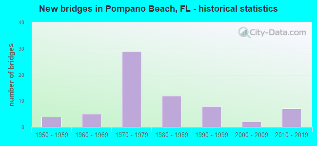
- New bridges - historical statistics
- 41950-1959
- 51960-1969
- 291970-1979
- 121980-1989
- 81990-1999
- 22000-2009
- 72010-2019
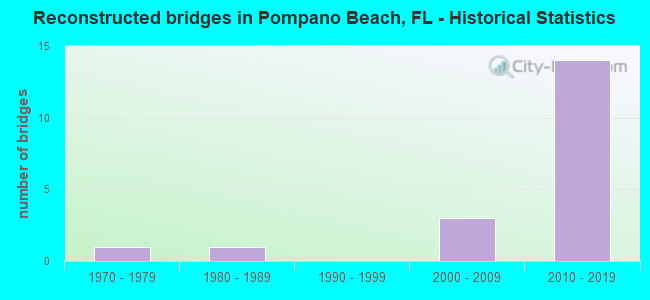
- Reconstructed bridges - Historical Statistics
- 11970-1979
- 11980-1989
- 01990-1999
- 32000-2009
- 142010-2019
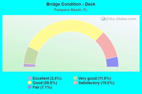
- Bridge Condition - Deck
- 2.4%Excellent
- 11.9%Very good
- 59.5%Good
- 19.0%Satisfactory
- 7.1%Fair
- Bridge Condition - Superstructure
- 2.4%Excellent
- 26.2%Very good
- 54.8%Good
- 7.1%Satisfactory
- 9.5%Fair
- Bridge Condition - Substructure
- 2.4%Excellent
- 16.7%Very good
- 69.0%Good
- 9.5%Satisfactory
- 2.4%Fair
- Bridge Condition - Channel
- 5.6%Excellent
- 11.1%Very good
- 66.7%Good
- 16.7%Satisfactory
Find on map >> Show street view
Structure Number: 860011, Location: .8mi North of SR 844 (Lat: 26.261444, Lng: -80.083167), Route carried "on" structure: State highway A1A, Year Built: 1966, Status: Open, Structure Length: 10.71m (35.14ft), Average Daily Traffic: 6,700 (year 2020), Truck Traffic: 3%, Average Future Daily Traffic: 11,624 (year 2042), Design Load: HS 20, Features Intersected: Hillsboro Inlet
Minimum Vertical Clearance: 5.33m (17.49ft), Kilometerpoint: 19.385, Lanes on structure: 2, Lanes under structure: 1, Owner: State Highway Agency, Approaching Roadway Width: 9.1m (29.9ft), Navigation Control: Yes ( Vertical Clearance: 3.2m (10.5ft), Horizontal Clearance: 18.3m (60.0ft)), Material/Design: Steel, Design/Construction: Movable - Bascule, Number Of Spans In Main Unit: 1, Number Of Approach Spans: 5, Length of Maximum Span: 22.7m (74.5ft), Curb or Sidewalk Widths: Left: 0.0m, Right: 1.5m (4.9ft), Curb-To-Curb Width: 9.1m (29.9ft), Out-to-Out Width: 11.7m (38.4ft)
Condition: Deck: Satisfactory, Superstructure: Good, Substructure: Good, Channel: Satisfactory, Operating Rating: 45.4 metric tons, Method Used To Determine Operating Rating: Load Factor (LF), Inventory Rating: 40.8 metric tons, Method Used To Determine Inventory Rating: Load Factor (LF), Structural Evaluation: Better than present minimum criteria, Deck Geometry: Meets minimum limits, Waterway Adequacy: Superior to present desirable criteria, Approach Roadway Alignment: Equal to present minimum criteria, Designated Inspection Frequency: Every 24 months, Critical Feature Inspection Frequency: Every 24 months, Underwater Inspection Frequency: Every 24 months, Other Special Inspection Frequency: Every 12 months, Inspection Date: August 2020, Critical Feature Inspection Date: August 2020, Underwater Inspection Date: August 2020, Other Special Inspection Date: August 2021, Deck Structure Type: Concrete Cast-file-Place
Find on map >> Show street view
Structure Number: 86006, Location: Between SR-A1A & US-1 (Lat: 26.250356, Lng: -80.089594), Route carried "on" structure: State highway 844, Year Built: 1967, Year Reconstructed: 2006, Status: Open, Structure Length: 10.69m (35.07ft), Average Daily Traffic: 13,700 (year 2020), Truck Traffic: 3%, Average Future Daily Traffic: 23,770 (year 2042), Design Load: HS 20, Features Intersected: Intracoastal Waterway, Facility Carried by Structure: 14 Street Causeway
Minimum Vertical Clearance: 30+ m (98+ ft), Kilometerpoint: 1.043, Lanes on structure: 4, Owner: State Highway Agency, Approaching Roadway Width: 18.3m (60.0ft), Skew: 30 degrees, Navigation Control: Yes ( Vertical Clearance: 4.6m (15.1ft), Horizontal Clearance: 27.4m (89.9ft)), Material/Design: Steel, Design/Construction: Movable - Bascule, Number Of Spans In Main Unit: 1, Number Of Approach Spans: 3, Length of Maximum Span: 37.6m (123.4ft), Curb or Sidewalk Widths: Left: 1.5m (4.9ft), Right: 1.5m (4.9ft), Curb-To-Curb Width: 18.3m (60.0ft), Out-to-Out Width: 22.3m (73.2ft)
Condition: Deck: Satisfactory, Superstructure: Fair, Substructure: Good, Channel: Good, Operating Rating: 55.6 metric tons, Method Used To Determine Operating Rating: Load Factor (LF), Inventory Rating: 32.7 metric tons, Method Used To Determine Inventory Rating: Load Factor (LF), Structural Evaluation: Somewhat better than minimum adequacy, Deck Geometry: Somewhat better than minimum adequacy, Waterway Adequacy: Superior to present desirable criteria, Approach Roadway Alignment: Better than present minimum criteria, Designated Inspection Frequency: Every 24 months, Critical Feature Inspection Frequency: Every 24 months, Underwater Inspection Frequency: Every 24 months, Other Special Inspection Frequency: Every 12 months, Inspection Date: July 2020, Critical Feature Inspection Date: July 2020, Underwater Inspection Date: July 2020, Other Special Inspection Date: July 2021, Deck Structure Type: Concrete Cast-file-Place
Find on map >> Show street view
Structure Number: 860082, Location: 0.2 M N POMPANO SER PLAZA (Lat: 26.230844, Lng: -80.178889), Route carried "on" structure: State highway 91, Year Built: 1956, Status: Open, Structure Length: 8.35m (27.40ft), Average Daily Traffic: 52,850 (year 2021), Truck Traffic: 13%, Average Future Daily Traffic: 91,695 (year 2042), Design Load: HS 20+Mod, Features Intersected: POMPANO CANAL C-14
Minimum Vertical Clearance: 30+ m (98+ ft), Kilometerpoint: 30.475, Lanes on structure: 3, Base Highway Network: Yes, Toll: On toll road, Owner: State Toll Authority, Approaching Roadway Width: 17.1m (56.1ft), Skew: 3 degrees, Material/Design: Steel, Design/Construction: Stringer/Multi-beam, Number Of Spans In Main Unit: 5, Length of Maximum Span: 18.3m (60.0ft), Curb-To-Curb Width: 17.1m (56.1ft), Out-to-Out Width: 18.0m (59.1ft)
Condition: Deck: Good, Superstructure: Good, Substructure: Good, Channel: Good, Operating Rating: 43.3 metric tons, Method Used To Determine Operating Rating: Load and Resistance Factor (LRFR), Inventory Rating: 33.4 metric tons, Method Used To Determine Inventory Rating: Load and Resistance Factor (LRFR), Structural Evaluation: Better than present minimum criteria, Deck Geometry: Equal to present minimum criteria, Waterway Adequacy: Equal to present minimum criteria, Approach Roadway Alignment: Equal to present desirable criteria, Designated Inspection Frequency: Every 24 months, Underwater Inspection Frequency: Every 24 months, Inspection Date: September 2021, Underwater Inspection Date: September 2021, Deck Structure Type: Concrete Cast-file-Place, Wearing Surface/Protective System: Wearing Surface: Bituminous
Find on map >> Show street view
Structure Number: 860118, Location: 1 m N of W Atlantic Blvd (Lat: 26.244061, Lng: -80.136697), Route carried "on" structure: Interstate 95, Year Built: 1971, Year Reconstructed: 2019, Status: Open, Structure Length: 4.42m (14.50ft), Average Daily Traffic: 105,000 (year 2020), Truck Traffic: 8%, Average Future Daily Traffic: 182,175 (year 2042), Design Load: HL 93, Features Intersected: FEC RAILROAD
Minimum Vertical Clearance: 30+ m (98+ ft), Kilometerpoint: 30.962, Lanes on structure: 6, Base Highway Network: Yes, Owner: State Highway Agency, Approaching Roadway Width: 25.6m (84.0ft), Material/Design: Prestressed concrete, Design/Construction: Stringer/Multi-beam, Number Of Spans In Main Unit: 3, Length of Maximum Span: 18.8m (61.7ft), Curb-To-Curb Width: 30.0m (98.4ft), Out-to-Out Width: 30.9m (101.4ft)
Condition: Deck: Good, Superstructure: Good, Substructure: Good, Operating Rating: 42.1 metric tons, Method Used To Determine Operating Rating: Load and Resistance Factor (LRFR), Inventory Rating: 33.0 metric tons, Method Used To Determine Inventory Rating: Load and Resistance Factor (LRFR), Structural Evaluation: Better than present minimum criteria, Deck Geometry: Superior to present desirable criteria, Underclear: Equal to present minimum criteria, Approach Roadway Alignment: Equal to present desirable criteria, Designated Inspection Frequency: Every 24 months, Inspection Date: March 2020, Deck Structure Type: Concrete Cast-file-Place
Find on map >> Show street view
Structure Number: 860119, Location: 1mi. N of Atlantic Blvd. (Lat: 26.245750, Lng: -80.136722), Route carried "on" structure: Interstate 95, Year Built: 1972, Year Reconstructed: 2019, Status: Open, Structure Length: 5.39m (17.68ft), Average Daily Traffic: 105,000 (year 2020), Truck Traffic: 8%, Average Future Daily Traffic: 182,175 (year 2042), Design Load: HS 20+Mod, Features Intersected: NW 15th St.
Minimum Vertical Clearance: 30+ m (98+ ft), Kilometerpoint: 31.146, Lanes on structure: 5, Lanes under structure: 2, Base Highway Network: Yes, Owner: State Highway Agency, Approaching Roadway Width: 20.7m (67.9ft), Material/Design: Prestressed concrete, Design/Construction: Stringer/Multi-beam, Number Of Spans In Main Unit: 3, Length of Maximum Span: 27.9m (91.5ft), Curb-To-Curb Width: 29.9m (98.1ft), Out-to-Out Width: 30.8m (101.0ft)
Condition: Deck: Good, Superstructure: Good, Substructure: Good, Operating Rating: 55.5 metric tons, Method Used To Determine Operating Rating: Load Factor (LF), Inventory Rating: 33.3 metric tons, Method Used To Determine Inventory Rating: Load Factor (LF), Structural Evaluation: Better than present minimum criteria, Deck Geometry: Superior to present desirable criteria, Underclear: Superior to present desirable criteria, Approach Roadway Alignment: Equal to present desirable criteria, Designated Inspection Frequency: Every 24 months, Inspection Date: April 2020, Deck Structure Type: Concrete Cast-file-Place
Find on map >> Show street view
Structure Number: 86012, Location: 2 mi. N of Atlantic Blvd. (Lat: 26.260519, Lng: -80.133278), Route carried "on" structure: Interstate 95, Year Built: 1972, Year Reconstructed: 2018, Status: Open, Structure Length: 8.84m (29.00ft), Average Daily Traffic: 105,000 (year 2020), Truck Traffic: 8%, Average Future Daily Traffic: 182,175 (year 2042), Design Load: HS 20+Mod, Features Intersected: Copans Road
Minimum Vertical Clearance: 30+ m (98+ ft), Kilometerpoint: 32.835, Lanes on structure: 6, Lanes under structure: 8, Base Highway Network: Yes, Owner: State Highway Agency, Approaching Roadway Width: 24.3m (79.7ft), Skew: 4 degrees, Material/Design: Prestressed concrete, Design/Construction: Stringer/Multi-beam, Number Of Spans In Main Unit: 4, Length of Maximum Span: 29.0m (95.1ft), Curb-To-Curb Width: 27.5m (90.2ft), Out-to-Out Width: 30.8m (101.0ft)
Condition: Deck: Good, Superstructure: Good, Substructure: Good, Operating Rating: 65.3 metric tons, Method Used To Determine Operating Rating: Load and Resistance Factor (LRFR), Inventory Rating: 50.3 metric tons, Method Used To Determine Inventory Rating: Load and Resistance Factor (LRFR), Structural Evaluation: Better than present minimum criteria, Deck Geometry: Equal to present minimum criteria, Underclear: Better than present minimum criteria, Approach Roadway Alignment: Equal to present desirable criteria, Designated Inspection Frequency: Every 24 months, Inspection Date: May 2021, Deck Structure Type: Concrete Cast-file-Place
Find on map >> Show street view
Structure Number: 860121, Location: 1.0 Mi N of Copans Rd. (Lat: 26.274928, Lng: -80.125164), Route carried "on" structure: Interstate 95, Year Built: 1974, Year Reconstructed: 2019, Status: Open, Structure Length: 6.83m (22.41ft), Average Daily Traffic: 105,000 (year 2020), Truck Traffic: 8%, Average Future Daily Traffic: 182,175 (year 2042), Design Load: HS 20+Mod, Features Intersected: SR-834 (Sample Road)
Minimum Vertical Clearance: 30+ m (98+ ft), Kilometerpoint: 34.726, Lanes on structure: 6, Lanes under structure: 8, Base Highway Network: Yes, Owner: State Highway Agency, Approaching Roadway Width: 27.9m (91.5ft), Material/Design: Prestressed concrete, Design/Construction: Stringer/Multi-beam, Number Of Spans In Main Unit: 4, Length of Maximum Span: 22.6m (74.1ft), Curb-To-Curb Width: 31.5m (103.3ft), Out-to-Out Width: 32.4m (106.3ft)
Condition: Deck: Good, Superstructure: Good, Substructure: Good, Operating Rating: 46.8 metric tons, Method Used To Determine Operating Rating: Load and Resistance Factor (LRFR), Inventory Rating: 35.9 metric tons, Method Used To Determine Inventory Rating: Load and Resistance Factor (LRFR), Structural Evaluation: Better than present minimum criteria, Deck Geometry: Superior to present desirable criteria, Underclear: Equal to present minimum criteria, Approach Roadway Alignment: Equal to present desirable criteria, Designated Inspection Frequency: Every 24 months, Inspection Date: June 2020, Deck Structure Type: Concrete Cast-file-Place
Find on map >> Show street view
Structure Number: 860157, Location: 300' W of A1A (Lat: 26.231783, Lng: -80.094436), Route carried "on" structure: State highway 814, Year Built: 1955, Status: Open, Structure Length: 11.53m (37.83ft), Average Daily Traffic: 23,000 (year 2020), Truck Traffic: 4%, Average Future Daily Traffic: 39,905 (year 2042), Design Load: H 15, Features Intersected: Intracoastal Waterway, Facility Carried by Structure: Atlantic Blvd.
Minimum Vertical Clearance: 4.79m (15.72ft), Kilometerpoint: 12.313, Lanes on structure: 4, Owner: State Highway Agency, Approaching Roadway Width: 25.0m (82.0ft), Skew: 20 degrees, Navigation Control: Yes ( Vertical Clearance: 4.6m (15.1ft), Horizontal Clearance: 27.4m (89.9ft)), Material/Design: Steel, Design/Construction: Movable - Bascule, Number Of Spans In Main Unit: 1, Number Of Approach Spans: 5, Length of Maximum Span: 43.0m (141.1ft), Curb or Sidewalk Widths: Left: 1.5m (4.9ft), Right: 1.5m (4.9ft), Curb-To-Curb Width: 13.4m (44.0ft), Out-to-Out Width: 17.6m (57.7ft)
Condition: Deck: Satisfactory, Superstructure: Good, Substructure: Good, Channel: Good, Operating Rating: 32.7 metric tons, Method Used To Determine Operating Rating: Load and Resistance Factor (LRFR), Inventory Rating: 25.1 metric tons, Method Used To Determine Inventory Rating: Load and Resistance Factor (LRFR), Structural Evaluation: Equal to present minimum criteria, Deck Geometry: High priority of replacement, Waterway Adequacy: Superior to present desirable criteria, Approach Roadway Alignment: Meets minimum limits, Designated Inspection Frequency: Every 24 months, Critical Feature Inspection Frequency: Every 24 months, Underwater Inspection Frequency: Every 24 months, Other Special Inspection Frequency: Every 12 months, Inspection Date: September 2020, Critical Feature Inspection Date: September 2020, Underwater Inspection Date: September 2020, Other Special Inspection Date: September 2021, Deck Structure Type: Concrete Cast-file-Place
Find on map >> Show street view
Structure Number: 860178, Location: 1.0 Mi. N of Copans Rd. (Lat: 26.274956, Lng: -80.124925), Route carried "on" structure: Interstate 95, Year Built: 1974, Year Reconstructed: 2019, Status: Open, Structure Length: 6.83m (22.41ft), Average Daily Traffic: 105,000 (year 2020), Truck Traffic: 8%, Average Future Daily Traffic: 182,175 (year 2042), Design Load: HS 20+Mod, Features Intersected: SR-834 (Sample Rd.)
Minimum Vertical Clearance: 30+ m (98+ ft), Kilometerpoint: 34.726, Lanes on structure: 6, Lanes under structure: 8, Base Highway Network: Yes, Owner: State Highway Agency, Approaching Roadway Width: 30.4m (99.7ft), Material/Design: Prestressed concrete, Design/Construction: Stringer/Multi-beam, Number Of Spans In Main Unit: 4, Length of Maximum Span: 22.6m (74.1ft), Curb-To-Curb Width: 30.4m (99.7ft), Out-to-Out Width: 32.4m (106.3ft)
Condition: Deck: Good, Superstructure: Good, Substructure: Good, Operating Rating: 46.8 metric tons, Method Used To Determine Operating Rating: Load and Resistance Factor (LRFR), Inventory Rating: 35.9 metric tons, Method Used To Determine Inventory Rating: Load and Resistance Factor (LRFR), Structural Evaluation: Better than present minimum criteria, Deck Geometry: Superior to present desirable criteria, Underclear: Equal to present minimum criteria, Approach Roadway Alignment: Equal to present desirable criteria, Designated Inspection Frequency: Every 24 months, Inspection Date: June 2020, Deck Structure Type: Concrete Cast-file-Place
Find on map >> Show street view
Structure Number: 860182, Location: 0.2 M N OF PPANO SER PLZA (Lat: 26.230767, Lng: -80.177936), Route carried "on" structure: State highway 91, Year Built: 1956, Year Reconstructed: 1991, Status: Open, Structure Length: 6.61m (21.69ft), Average Daily Traffic: 52,850 (year 2021), Truck Traffic: 13%, Average Future Daily Traffic: 91,695 (year 2042), Design Load: HS 20+Mod, Features Intersected: POMPANO CANAL C-14
Minimum Vertical Clearance: 30+ m (98+ ft), Kilometerpoint: 30.471, Lanes on structure: 4, Base Highway Network: Yes, Toll: On toll road, Owner: State Toll Authority, Approaching Roadway Width: 19.8m (65.0ft), Skew: 5 degrees, Material/Design: Steel, Design/Construction: Stringer/Multi-beam, Number Of Spans In Main Unit: 5, Length of Maximum Span: 14.9m (48.9ft), Curb-To-Curb Width: 20.1m (65.9ft), Out-to-Out Width: 21.0m (68.9ft)
Condition: Deck: Good, Superstructure: Good, Substructure: Good, Channel: Good, Operating Rating: 74.9 metric tons, Method Used To Determine Operating Rating: Load Factor (LF), Inventory Rating: 45.0 metric tons, Method Used To Determine Inventory Rating: Load Factor (LF), Structural Evaluation: Better than present minimum criteria, Deck Geometry: Equal to present minimum criteria, Waterway Adequacy: Equal to present desirable criteria, Approach Roadway Alignment: Equal to present desirable criteria, Designated Inspection Frequency: Every 24 months, Underwater Inspection Frequency: Every 24 months, Inspection Date: September 2021, Underwater Inspection Date: September 2021, Deck Structure Type: Concrete Cast-file-Place, Wearing Surface/Protective System: Wearing Surface: Bituminous
Find on map >> Show street view
Structure Number: 860218, Location: 1.0Mi N/O W Atlantic Blvd (Lat: 26.243842, Lng: -80.136311), Route carried "on" structure: Interstate 95, Year Built: 1971, Year Reconstructed: 2019, Status: Open, Structure Length: 4.42m (14.50ft), Average Daily Traffic: 105,000 (year 2020), Truck Traffic: 8%, Average Future Daily Traffic: 182,175 (year 2042), Design Load: HL 93, Features Intersected: FEC RAILROAD
Minimum Vertical Clearance: 30+ m (98+ ft), Kilometerpoint: 30.962, Lanes on structure: 6, Base Highway Network: Yes, Owner: State Highway Agency, Approaching Roadway Width: 25.6m (84.0ft), Material/Design: Prestressed concrete, Design/Construction: Stringer/Multi-beam, Number Of Spans In Main Unit: 3, Length of Maximum Span: 18.8m (61.7ft), Curb-To-Curb Width: 29.7m (97.4ft), Out-to-Out Width: 30.6m (100.4ft)
Condition: Deck: Good, Superstructure: Good, Substructure: Good, Operating Rating: 42.1 metric tons, Method Used To Determine Operating Rating: Load and Resistance Factor (LRFR), Inventory Rating: 33.0 metric tons, Method Used To Determine Inventory Rating: Load and Resistance Factor (LRFR), Structural Evaluation: Better than present minimum criteria, Deck Geometry: Superior to present desirable criteria, Underclear: Equal to present minimum criteria, Approach Roadway Alignment: Equal to present desirable criteria, Designated Inspection Frequency: Every 24 months, Inspection Date: March 2020, Deck Structure Type: Concrete Cast-file-Place
Find on map >> Show street view
Structure Number: 860219, Location: 1mi. N of Atlantic Blvd. (Lat: 26.245750, Lng: -80.136444), Route carried "on" structure: Interstate 95, Year Built: 1972, Year Reconstructed: 2019, Status: Open, Structure Length: 5.39m (17.68ft), Average Daily Traffic: 105,000 (year 2020), Truck Traffic: 8%, Average Future Daily Traffic: 182,175 (year 2042), Design Load: HS 20+Mod, Features Intersected: NW 15th Street
Minimum Vertical Clearance: 30+ m (98+ ft), Kilometerpoint: 31.146, Lanes on structure: 5, Lanes under structure: 2, Base Highway Network: Yes, Owner: State Highway Agency, Approaching Roadway Width: 29.8m (97.8ft), Material/Design: Prestressed concrete, Design/Construction: Stringer/Multi-beam, Number Of Spans In Main Unit: 3, Length of Maximum Span: 27.9m (91.5ft), Curb-To-Curb Width: 29.8m (97.8ft), Out-to-Out Width: 30.7m (100.7ft)
Condition: Deck: Good, Superstructure: Good, Substructure: Very good, Operating Rating: 55.2 metric tons, Method Used To Determine Operating Rating: Load Factor (LF), Inventory Rating: 33.0 metric tons, Method Used To Determine Inventory Rating: Load Factor (LF), Structural Evaluation: Better than present minimum criteria, Deck Geometry: Superior to present desirable criteria, Underclear: Superior to present desirable criteria, Approach Roadway Alignment: Equal to present desirable criteria, Designated Inspection Frequency: Every 24 months, Inspection Date: April 2020, Deck Structure Type: Concrete Cast-file-Place
Find on map >> Show street view
Structure Number: 86022, Location: 2 mi. N of Atlantic Blvd. (Lat: 26.260519, Lng: -80.132967), Route carried "on" structure: Interstate 95, Year Built: 1972, Year Reconstructed: 2018, Status: Open, Structure Length: 8.84m (29.00ft), Average Daily Traffic: 105,000 (year 2020), Truck Traffic: 8%, Average Future Daily Traffic: 182,175 (year 2042), Design Load: HS 20+Mod, Features Intersected: Copans Rd.
Minimum Vertical Clearance: 30+ m (98+ ft), Kilometerpoint: 3.903, Lanes on structure: 6, Lanes under structure: 7, Base Highway Network: Yes, Owner: State Highway Agency, Approaching Roadway Width: 24.3m (79.7ft), Skew: 4 degrees, Material/Design: Prestressed concrete, Design/Construction: Stringer/Multi-beam, Number Of Spans In Main Unit: 4, Length of Maximum Span: 29.0m (95.1ft), Curb-To-Curb Width: 24.7m (81.0ft), Out-to-Out Width: 32.3m (106.0ft)
Condition: Deck: Good, Superstructure: Good, Substructure: Good, Operating Rating: 63.3 metric tons, Method Used To Determine Operating Rating: Load and Resistance Factor (LRFR), Inventory Rating: 43.7 metric tons, Method Used To Determine Inventory Rating: Load and Resistance Factor (LRFR), Structural Evaluation: Better than present minimum criteria, Deck Geometry: Meets minimum limits, Underclear: Better than present minimum criteria, Approach Roadway Alignment: Equal to present desirable criteria, Designated Inspection Frequency: Every 24 months, Inspection Date: May 2021, Deck Structure Type: Concrete Cast-file-Place
Find on map >> Show street view
Structure Number: 860222, Location: 1 mile South of SR-814 (Lat: 26.221208, Lng: -80.103914), Route carried "on" structure: US 1, Year Built: 1982, Status: Open, Structure Length: 7.85m (25.75ft), Average Daily Traffic: 41,000 (year 2020), Truck Traffic: 4%, Average Future Daily Traffic: 71,135 (year 2042), Design Load: HS 20, Features Intersected: Cypress Creek Canal C-14
Minimum Vertical Clearance: 30+ m (98+ ft), Kilometerpoint: 12.933, Lanes on structure: 6, Base Highway Network: Yes, Owner: State Highway Agency, Approaching Roadway Width: 31.3m (102.7ft), Skew: 20 degrees, Navigation Control: Yes ( Vertical Clearance: 3.7m (12.1ft), Horizontal Clearance: 14.0m (45.9ft)), Material/Design: Prestressed concrete, Design/Construction: Stringer/Multi-beam, Number Of Spans In Main Unit: 5, Length of Maximum Span: 15.7m (51.5ft), Curb or Sidewalk Widths: Left: 1.5m (4.9ft), Right: 1.5m (4.9ft), Curb-To-Curb Width: 31.3m (102.7ft), Out-to-Out Width: 35.4m (116.1ft)
Condition: Deck: Good, Superstructure: Very good, Substructure: Good, Channel: Very good, Operating Rating: 53.1 metric tons, Method Used To Determine Operating Rating: Load Factor (LF), Inventory Rating: 47.6 metric tons, Method Used To Determine Inventory Rating: Load Factor (LF), Structural Evaluation: Better than present minimum criteria, Deck Geometry: Superior to present desirable criteria, Waterway Adequacy: Superior to present desirable criteria, Approach Roadway Alignment: Equal to present desirable criteria, Designated Inspection Frequency: Every 24 months, Underwater Inspection Frequency: Every 24 months, Inspection Date: August 2020, Underwater Inspection Date: August 2020, Deck Structure Type: Concrete Cast-file-Place
Find on map >> Show street view
Structure Number: 860231, Location: 2.0 Mi South of Copans Rd (Lat: 26.231517, Lng: -80.136567), Route carried "on" structure: Interstate 95, Year Built: 1975, Year Reconstructed: 2018, Status: Open, Structure Length: 6.46m (21.19ft), Average Daily Traffic: 105,000 (year 2020), Truck Traffic: 8%, Average Future Daily Traffic: 182,175 (year 2042), Design Load: HS 20+Mod, Features Intersected: SR-814 (Atlantic Blvd.)
Minimum Vertical Clearance: 30+ m (98+ ft), Kilometerpoint: 29.565, Lanes on structure: 5, Lanes under structure: 8, Base Highway Network: Yes, Owner: State Highway Agency, Approaching Roadway Width: 25.7m (84.3ft), Material/Design: Prestressed concrete, Design/Construction: Stringer/Multi-beam, Number Of Spans In Main Unit: 4, Length of Maximum Span: 22.4m (73.5ft), Curb-To-Curb Width: 25.7m (84.3ft), Out-to-Out Width: 26.8m (87.9ft)
Condition: Deck: Good, Superstructure: Good, Substructure: Good, Operating Rating: 36.6 metric tons, Method Used To Determine Operating Rating: Load and Resistance Factor (LRFR), Inventory Rating: 32.7 metric tons, Method Used To Determine Inventory Rating: Load and Resistance Factor (LRFR), Structural Evaluation: Better than present minimum criteria, Deck Geometry: Better than present minimum criteria, Underclear: Meets minimum limits, Approach Roadway Alignment: Equal to present desirable criteria, Designated Inspection Frequency: Every 24 months, Inspection Date: April 2020, Deck Structure Type: Concrete Cast-file-Place
Find on map >> Show street view
Structure Number: 860232, Location: 2.0 Mi South of COPANS RD (Lat: 26.231514, Lng: -80.136344), Route carried "on" structure: Interstate 95, Year Built: 1975, Year Reconstructed: 2019, Status: Open, Structure Length: 6.46m (21.19ft), Average Daily Traffic: 105,000 (year 2020), Truck Traffic: 8%, Average Future Daily Traffic: 182,175 (year 2042), Design Load: HS 20+Mod, Features Intersected: SR-814 (Atlantic Blvd.)
Minimum Vertical Clearance: 30+ m (98+ ft), Kilometerpoint: 29.565, Lanes on structure: 5, Lanes under structure: 8, Base Highway Network: Yes, Owner: State Highway Agency, Approaching Roadway Width: 26.6m (87.3ft), Material/Design: Prestressed concrete, Design/Construction: Stringer/Multi-beam, Number Of Spans In Main Unit: 4, Length of Maximum Span: 22.4m (73.5ft), Curb-To-Curb Width: 26.6m (87.3ft), Out-to-Out Width: 27.3m (89.6ft)
Condition: Deck: Good, Superstructure: Good, Substructure: Good, Operating Rating: 36.6 metric tons, Method Used To Determine Operating Rating: Load and Resistance Factor (LRFR), Inventory Rating: 32.7 metric tons, Method Used To Determine Inventory Rating: Load and Resistance Factor (LRFR), Structural Evaluation: Better than present minimum criteria, Deck Geometry: Superior to present desirable criteria, Underclear: Meets minimum limits, Approach Roadway Alignment: Equal to present desirable criteria, Designated Inspection Frequency: Every 24 months, Inspection Date: April 2020, Deck Structure Type: Concrete Cast-file-Place
Find on map >> Show street view
Structure Number: 860233, Location: 1.2 Mi E of Powerline Rd (Lat: 26.226608, Lng: -80.136389), Route carried "on" structure: City street , Year Built: 1975, Status: Open, Structure Length: 9.14m (29.99ft), Average Daily Traffic: 10,700 (year 2020), Truck Traffic: 9%, Average Future Daily Traffic: 18,564 (year 2042), Design Load: HS 20+Mod, Features Intersected: I-95(SR-9), Facility Carried by Structure: SW 3rd St.
Minimum Vertical Clearance: 30+ m (98+ ft), Kilometerpoint: 1.968, Lanes on structure: 6, Lanes under structure: 12, Owner: State Highway Agency, Approaching Roadway Width: 25.9m (85.0ft), Skew: 20 degrees, Material/Design: Prestressed concrete, Design/Construction: Stringer/Multi-beam, Number Of Spans In Main Unit: 4, Length of Maximum Span: 34.7m (113.8ft), Curb or Sidewalk Widths: Left: 1.5m (4.9ft), Right: 1.5m (4.9ft), Curb-To-Curb Width: 25.9m (85.0ft), Out-to-Out Width: 29.9m (98.1ft)
Condition: Deck: Satisfactory, Superstructure: Good, Substructure: Very good, Operating Rating: 54.4 metric tons, Method Used To Determine Operating Rating: Load Testing, Inventory Rating: 32.7 metric tons, Method Used To Determine Inventory Rating: Load Testing, Structural Evaluation: Better than present minimum criteria, Deck Geometry: Equal to present minimum criteria, Underclear: Somewhat better than minimum adequacy, Approach Roadway Alignment: Better than present minimum criteria, Designated Inspection Frequency: Every 24 months, Inspection Date: March 2021, Deck Structure Type: Concrete Cast-file-Place
Find on map >> Show street view
Structure Number: 860235, Location: 0.2mi N of Atlantic Blvd. (Lat: 26.234278, Lng: -80.136647), Route carried "on" structure: Interstate 95, Year Built: 1975, Year Reconstructed: 2018, Status: Open, Structure Length: 5.39m (17.68ft), Average Daily Traffic: 105,000 (year 2020), Truck Traffic: 8%, Average Future Daily Traffic: 182,175 (year 2042), Design Load: HS 20+Mod, Features Intersected: Hammonville/MLK Blvd.
Minimum Vertical Clearance: 30+ m (98+ ft), Kilometerpoint: 29.881, Lanes on structure: 5, Lanes under structure: 5, Base Highway Network: Yes, Owner: State Highway Agency, Approaching Roadway Width: 34.1m (111.9ft), Skew: 1 degrees, Material/Design: Prestressed concrete, Design/Construction: Stringer/Multi-beam, Number Of Spans In Main Unit: 3, Length of Maximum Span: 28.4m (93.2ft), Curb-To-Curb Width: 34.1m (111.9ft), Out-to-Out Width: 41.1m (134.8ft)
Condition: Deck: Good, Superstructure: Good, Substructure: Good, Operating Rating: 35.9 metric tons, Method Used To Determine Operating Rating: Load and Resistance Factor (LRFR), Inventory Rating: 28.4 metric tons, Method Used To Determine Inventory Rating: Load and Resistance Factor (LRFR), Structural Evaluation: Better than present minimum criteria, Deck Geometry: Superior to present desirable criteria, Underclear: Meets minimum limits, Approach Roadway Alignment: Equal to present desirable criteria, Designated Inspection Frequency: Every 24 months, Inspection Date: April 2020, Deck Structure Type: Concrete Cast-file-Place
Find on map >> Show street view
Structure Number: 860236, Location: 0.2mi N of Atlantic Blvd. (Lat: 26.234194, Lng: -80.136306), Route carried "on" structure: Interstate 95, Year Built: 1975, Year Reconstructed: 2019, Status: Open, Structure Length: 5.33m (17.49ft), Average Daily Traffic: 105,000 (year 2020), Truck Traffic: 8%, Average Future Daily Traffic: 182,175 (year 2042), Design Load: HS 20+Mod, Features Intersected: Hammonville/MLK Blvd
Minimum Vertical Clearance: 30+ m (98+ ft), Kilometerpoint: 29.869, Lanes on structure: 7, Lanes under structure: 5, Base Highway Network: Yes, Owner: State Highway Agency, Approaching Roadway Width: 30.4m (99.7ft), Material/Design: Prestressed concrete, Design/Construction: Stringer/Multi-beam, Number Of Spans In Main Unit: 3, Length of Maximum Span: 28.4m (93.2ft), Curb-To-Curb Width: 30.4m (99.7ft), Out-to-Out Width: 41.2m (135.2ft)
Condition: Deck: Very good, Superstructure: Good, Substructure: Good, Operating Rating: 35.9 metric tons, Method Used To Determine Operating Rating: Load and Resistance Factor (LRFR), Inventory Rating: 30.7 metric tons, Method Used To Determine Inventory Rating: Load and Resistance Factor (LRFR), Structural Evaluation: Better than present minimum criteria, Deck Geometry: Somewhat better than minimum adequacy, Underclear: Somewhat better than minimum adequacy, Approach Roadway Alignment: Equal to present desirable criteria, Designated Inspection Frequency: Every 24 months, Inspection Date: April 2020, Deck Structure Type: Concrete Cast-file-Place
Find on map >> Show street view
Structure Number: 860241, Location: 0.6mi. N of Cypress Ck Rd (Lat: 26.210628, Lng: -80.137425), Route carried "on" structure: Interstate 95, Year Built: 1976, Year Reconstructed: 2019, Status: Open, Structure Length: 8.72m (28.61ft), Average Daily Traffic: 105,000 (year 2020), Truck Traffic: 8%, Average Future Daily Traffic: 182,175 (year 2042), Design Load: HS 20+Mod, Features Intersected: Mc Nab Rd.
Minimum Vertical Clearance: 30+ m (98+ ft), Kilometerpoint: 27.200, Lanes on structure: 5, Lanes under structure: 6, Base Highway Network: Yes, Owner: State Highway Agency, Approaching Roadway Width: 30.0m (98.4ft), Skew: 2 degrees, Material/Design: Prestressed concrete, Design/Construction: Stringer/Multi-beam, Number Of Spans In Main Unit: 4, Length of Maximum Span: 29.6m (97.1ft), Curb-To-Curb Width: 30.0m (98.4ft), Out-to-Out Width: 30.7m (100.7ft)
Condition: Deck: Good, Superstructure: Very good, Substructure: Very good, Operating Rating: 47.7 metric tons, Method Used To Determine Operating Rating: Load and Resistance Factor (LRFR), Inventory Rating: 37.2 metric tons, Method Used To Determine Inventory Rating: Load and Resistance Factor (LRFR), Structural Evaluation: Equal to present desirable criteria, Deck Geometry: Superior to present desirable criteria, Underclear: Superior to present desirable criteria, Approach Roadway Alignment: Equal to present desirable criteria, Designated Inspection Frequency: Every 24 months, Inspection Date: June 2020, Deck Structure Type: Concrete Cast-file-Place
Find on map >> Show street view
Structure Number: 860242, Location: 1mi. So. of Atlantic Blvd (Lat: 26.210611, Lng: -80.137167), Route carried "on" structure: Interstate 95, Year Built: 1976, Year Reconstructed: 2019, Status: Open, Structure Length: 8.72m (28.61ft), Average Daily Traffic: 105,000 (year 2020), Truck Traffic: 8%, Average Future Daily Traffic: 182,175 (year 2042), Design Load: HS 20+Mod, Features Intersected: Mc Nab Rd.
Minimum Vertical Clearance: 30+ m (98+ ft), Kilometerpoint: 27.214, Lanes on structure: 5, Lanes under structure: 6, Base Highway Network: Yes, Owner: State Highway Agency, Approaching Roadway Width: 29.9m (98.1ft), Skew: 2 degrees, Material/Design: Prestressed concrete, Design/Construction: Stringer/Multi-beam, Number Of Spans In Main Unit: 4, Length of Maximum Span: 29.6m (97.1ft), Curb-To-Curb Width: 29.9m (98.1ft), Out-to-Out Width: 30.9m (101.4ft)
Condition: Deck: Good, Superstructure: Good, Substructure: Good, Operating Rating: 44.5 metric tons, Method Used To Determine Operating Rating: Load and Resistance Factor (LRFR), Inventory Rating: 32.7 metric tons, Method Used To Determine Inventory Rating: Load and Resistance Factor (LRFR), Structural Evaluation: Better than present minimum criteria, Deck Geometry: Superior to present desirable criteria, Underclear: Superior to present desirable criteria, Approach Roadway Alignment: Equal to present desirable criteria, Designated Inspection Frequency: Every 24 months, Inspection Date: June 2020, Deck Structure Type: Concrete Cast-file-Place
Find on map >> Show street view
Structure Number: 860372, Location: 0.5 MI. SO. OF SAMPLE RD (Lat: 26.259897, Lng: -80.167367), Route carried "on" structure: State highway 91, Year Built: 1982, Status: Open, Structure Length: 5.36m (17.59ft), Average Daily Traffic: 45,850 (year 2021), Truck Traffic: 13%, Average Future Daily Traffic: 79,550 (year 2042), Design Load: HS 20, Features Intersected: COPANS RD
Minimum Vertical Clearance: 30+ m (98+ ft), Kilometerpoint: 34.046, Lanes on structure: 3, Lanes under structure: 5, Base Highway Network: Yes, Toll: On toll road, Owner: State Toll Authority, Approaching Roadway Width: 17.1m (56.1ft), Skew: 1 degrees, Material/Design: Prestressed concrete, Design/Construction: Stringer/Multi-beam, Number Of Spans In Main Unit: 2, Length of Maximum Span: 26.5m (86.9ft), Curb-To-Curb Width: 16.5m (54.1ft), Out-to-Out Width: 17.1m (56.1ft)
Condition: Deck: Good, Superstructure: Very good, Substructure: Good, Operating Rating: 37.6 metric tons, Method Used To Determine Operating Rating: Load and Resistance Factor (LRFR), Inventory Rating: 34.7 metric tons, Method Used To Determine Inventory Rating: Load and Resistance Factor (LRFR), Structural Evaluation: Better than present minimum criteria, Deck Geometry: Equal to present minimum criteria, Underclear: Equal to present minimum criteria, Approach Roadway Alignment: Equal to present desirable criteria, Designated Inspection Frequency: Every 24 months, Inspection Date: September 2021, Deck Structure Type: Concrete Cast-file-Place
Find on map >> Show street view
Structure Number: 860373, Location: 0.5 MI.SO. OF SAMPLE ROAD (Lat: 26.259903, Lng: -80.167192), Route carried "on" structure: State highway 91, Year Built: 1983, Status: Open, Structure Length: 5.39m (17.68ft), Average Daily Traffic: 45,850 (year 2021), Truck Traffic: 13%, Average Future Daily Traffic: 79,550 (year 2042), Design Load: HS 20, Features Intersected: COPANS RD
Minimum Vertical Clearance: 30+ m (98+ ft), Kilometerpoint: 34.038, Lanes on structure: 3, Lanes under structure: 5, Base Highway Network: Yes, Toll: On toll road, Owner: State Toll Authority, Approaching Roadway Width: 16.5m (54.1ft), Skew: 1 degrees, Material/Design: Prestressed concrete, Design/Construction: Stringer/Multi-beam, Number Of Spans In Main Unit: 2, Length of Maximum Span: 26.5m (86.9ft), Curb-To-Curb Width: 16.8m (55.1ft), Out-to-Out Width: 17.7m (58.1ft)
Condition: Deck: Good, Superstructure: Very good, Substructure: Good, Operating Rating: 37.9 metric tons, Method Used To Determine Operating Rating: Load and Resistance Factor (LRFR), Inventory Rating: 34.9 metric tons, Method Used To Determine Inventory Rating: Load and Resistance Factor (LRFR), Structural Evaluation: Better than present minimum criteria, Deck Geometry: Equal to present minimum criteria, Underclear: Equal to present minimum criteria, Approach Roadway Alignment: Equal to present desirable criteria, Designated Inspection Frequency: Every 24 months, Inspection Date: September 2021, Deck Structure Type: Concrete Cast-file-Place
Find on map >> Show street view
Structure Number: 860405, Location: 0.1 MI SOUTH OF SAMPLE RD (Lat: 26.270639, Lng: -80.168867), Route carried "on" structure: Ramp State highway 91, Year Built: 1984, Status: Open, Structure Length: 7.51m (24.64ft), Average Daily Traffic: 4,250 (year 2021), Truck Traffic: 13%, Average Future Daily Traffic: 7,374 (year 2042), Design Load: HS 20+Mod, Features Intersected: SR 91 TPK(SAMPLE RD INT)
Minimum Vertical Clearance: 30+ m (98+ ft), Kilometerpoint: 0.552, Lanes on structure: 2, Lanes under structure: 7, Toll: On toll road, Owner: State Toll Authority, Approaching Roadway Width: 15.8m (51.8ft), Skew: 30 degrees, Material/Design: Prestressed concrete, Design/Construction: Stringer/Multi-beam, Number Of Spans In Main Unit: 4, Length of Maximum Span: 24.4m (80.1ft), Curb-To-Curb Width: 15.2m (49.9ft), Out-to-Out Width: 16.6m (54.5ft)
Condition: Deck: Good, Superstructure: Good, Substructure: Good, Channel: Good, Operating Rating: 44.5 metric tons, Method Used To Determine Operating Rating: Load and Resistance Factor (LRFR), Inventory Rating: 35.3 metric tons, Method Used To Determine Inventory Rating: Load and Resistance Factor (LRFR), Structural Evaluation: Better than present minimum criteria, Deck Geometry: Superior to present desirable criteria, Underclear: Somewhat better than minimum adequacy, Approach Roadway Alignment: Better than present minimum criteria, Designated Inspection Frequency: Every 24 months, Inspection Date: September 2021, Deck Structure Type: Concrete Cast-file-Place
Find on map >> Show street view
Structure Number: 86041, Location: 1 mi south of SR- 814 (Lat: 26.215517, Lng: -80.156067), Route carried "on" structure: State highway 845, Year Built: 1962, Year Reconstructed: 1983, Status: Open, Structure Length: 4.72m (15.49ft), Average Daily Traffic: 49,000 (year 2021), Truck Traffic: 9%, Average Future Daily Traffic: 85,015 (year 2042), Design Load: HS 20, Features Intersected: C-14 Canal
Minimum Vertical Clearance: 30+ m (98+ ft), Kilometerpoint: 8.753, Lanes on structure: 6, Base Highway Network: Yes, Owner: State Highway Agency, Approaching Roadway Width: 24.2m (79.4ft), Skew: 20 degrees, Material/Design: Prestressed concrete, Design/Construction: Slab, Number Of Spans In Main Unit: 5, Length of Maximum Span: 9.4m (30.8ft), Curb or Sidewalk Widths: Left: 1.5m (4.9ft), Right: 1.8m (5.9ft), Curb-To-Curb Width: 24.2m (79.4ft), Out-to-Out Width: 32.9m (107.9ft)
Condition: Deck: Fair, Superstructure: Fair, Substructure: Good, Channel: Good, Operating Rating: 58.1 metric tons, Method Used To Determine Operating Rating: Load Factor (LF), Inventory Rating: 46.3 metric tons, Method Used To Determine Inventory Rating: Load Factor (LF), Structural Evaluation: Somewhat better than minimum adequacy, Deck Geometry: Somewhat better than minimum adequacy, Waterway Adequacy: Equal to present desirable criteria, Approach Roadway Alignment: Equal to present desirable criteria, Designated Inspection Frequency: Every 24 months, Underwater Inspection Frequency: Every 24 months, Inspection Date: October 2021, Underwater Inspection Date: October 2021, Deck Structure Type: Concrete Precast Panels, Wearing Surface/Protective System: Wearing Surface: Bituminous
Find on map >> Show street view
Structure Number: 860464, Location: S OF POMPANO SERVICE PLAZ (Lat: 26.219053, Lng: -80.188164), Route carried "on" structure: State highway 91, Year Built: 1984, Year Reconstructed: 2008, Status: Open, Structure Length: 9.13m (29.95ft), Average Daily Traffic: 52,850 (year 2021), Truck Traffic: 13%, Average Future Daily Traffic: 91,695 (year 2042), Design Load: HL 93, Features Intersected: NW 31ST AVE
Minimum Vertical Clearance: 30+ m (98+ ft), Kilometerpoint: 28.817, Lanes on structure: 5, Lanes under structure: 4, Base Highway Network: Yes, Toll: On toll road, Owner: State Toll Authority, Approaching Roadway Width: 26.5m (86.9ft), Skew: 5 degrees, Material/Design: Prestressed concrete, Design/Construction: Stringer/Multi-beam, Number Of Spans In Main Unit: 4, Length of Maximum Span: 30.8m (101.0ft), Curb-To-Curb Width: 25.6m (84.0ft), Out-to-Out Width: 26.4m (86.6ft)
Condition: Deck: Good, Superstructure: Very good, Substructure: Good, Operating Rating: 41.5 metric tons, Method Used To Determine Operating Rating: Load and Resistance Factor (LRFR), Inventory Rating: 36.9 metric tons, Method Used To Determine Inventory Rating: Load and Resistance Factor (LRFR), Structural Evaluation: Better than present minimum criteria, Deck Geometry: Better than present minimum criteria, Underclear: Superior to present desirable criteria, Approach Roadway Alignment: Equal to present desirable criteria, Designated Inspection Frequency: Every 24 months, Inspection Date: September 2021, Deck Structure Type: Concrete Cast-file-Place
Find on map >> Show street view
Structure Number: 860465, Location: S OF POMPANO SERVICE PLAZ (Lat: 26.218631, Lng: -80.188203), Route carried "on" structure: State highway 91, Year Built: 1984, Year Reconstructed: 2012, Status: Open, Structure Length: 9.13m (29.95ft), Average Daily Traffic: 52,850 (year 2021), Truck Traffic: 13%, Average Future Daily Traffic: 91,695 (year 2042), Design Load: HL 93, Features Intersected: NW 31st AVE
Minimum Vertical Clearance: 30+ m (98+ ft), Kilometerpoint: 28.761, Lanes on structure: 4, Lanes under structure: 4, Base Highway Network: Yes, Toll: On toll road, Owner: State Toll Authority, Approaching Roadway Width: 21.9m (71.9ft), Skew: 5 degrees, Material/Design: Prestressed concrete, Design/Construction: Stringer/Multi-beam, Number Of Spans In Main Unit: 4, Length of Maximum Span: 30.6m (100.4ft), Curb-To-Curb Width: 21.9m (71.9ft), Out-to-Out Width: 22.8m (74.8ft)
Condition: Deck: Good, Superstructure: Very good, Substructure: Good, Operating Rating: 43.7 metric tons, Method Used To Determine Operating Rating: Load and Resistance Factor (LRFR), Inventory Rating: 39.5 metric tons, Method Used To Determine Inventory Rating: Load and Resistance Factor (LRFR), Structural Evaluation: Better than present minimum criteria, Deck Geometry: Better than present minimum criteria, Underclear: Superior to present desirable criteria, Approach Roadway Alignment: Equal to present desirable criteria, Designated Inspection Frequency: Every 24 months, Inspection Date: September 2021, Deck Structure Type: Concrete Cast-file-Place
Find on map >> Show street view
Structure Number: 860587, Location: 2 MILES SOUTH OF SR-834 (Lat: 26.245206, Lng: -80.167486), Route carried "on" structure: County highway 912, Year Built: 1991, Status: Open, Structure Length: 5.36m (17.59ft), Average Daily Traffic: 16,000 (year 2021), Truck Traffic: 9%, Average Future Daily Traffic: 27,760 (year 2042), Design Load: HS 20+Mod, Features Intersected: SR 91 TPK, Facility Carried by Structure: HMMNDVLL RD 67.348
Minimum Vertical Clearance: 30+ m (98+ ft), Kilometerpoint: 3.349, Lanes on structure: 6, Lanes under structure: 6, Owner: State Toll Authority, Approaching Roadway Width: 34.1m (111.9ft), Skew: 20 degrees, Material/Design: Prestressed concrete, Design/Construction: Stringer/Multi-beam, Number Of Spans In Main Unit: 2, Length of Maximum Span: 26.8m (87.9ft), Curb or Sidewalk Widths: Left: 2.1m (6.9ft), Right: 2.1m (6.9ft), Curb-To-Curb Width: 34.1m (111.9ft), Out-to-Out Width: 39.9m (130.9ft)
Condition: Deck: Good, Superstructure: Very good, Substructure: Good, Operating Rating: 38.6 metric tons, Method Used To Determine Operating Rating: Load and Resistance Factor (LRFR), Inventory Rating: 29.8 metric tons, Method Used To Determine Inventory Rating: Load and Resistance Factor (LRFR), Structural Evaluation: Better than present minimum criteria, Deck Geometry: Superior to present desirable criteria, Underclear: Equal to present minimum criteria, Approach Roadway Alignment: Equal to present desirable criteria, Designated Inspection Frequency: Every 24 months, Inspection Date: September 2021, Deck Structure Type: Concrete Cast-file-Place
Find on map >> Show street view
Structure Number: 860588, Location: 3.8 MI S OF SR-869 (Lat: 26.249128, Lng: -80.166572), Route carried "on" structure: Ramp State highway 91, Year Built: 1992, Status: Open, Structure Length: 5.06m (16.60ft), Average Daily Traffic: 6,350 (year 2021), Truck Traffic: 13%, Average Future Daily Traffic: 11,017 (year 2042), Design Load: HS 20+Mod, Features Intersected: SR 91 TPK (COCO CK INT)
Minimum Vertical Clearance: 30+ m (98+ ft), Kilometerpoint: 0.446, Lanes on structure: 2, Lanes under structure: 7, Toll: On toll road, Owner: State Toll Authority, Approaching Roadway Width: 15.5m (50.9ft), Skew: 30 degrees, Material/Design: Prestressed concrete, Design/Construction: Stringer/Multi-beam, Number Of Spans In Main Unit: 2, Length of Maximum Span: 25.3m (83.0ft), Curb-To-Curb Width: 15.2m (49.9ft), Out-to-Out Width: 16.8m (55.1ft)
Condition: Deck: Good, Superstructure: Good, Substructure: Good, Operating Rating: 38.2 metric tons, Method Used To Determine Operating Rating: Load and Resistance Factor (LRFR), Inventory Rating: 29.4 metric tons, Method Used To Determine Inventory Rating: Load and Resistance Factor (LRFR), Structural Evaluation: Better than present minimum criteria, Deck Geometry: Superior to present desirable criteria, Underclear: Somewhat better than minimum adequacy, Approach Roadway Alignment: Equal to present desirable criteria, Designated Inspection Frequency: Every 24 months, Inspection Date: September 2021, Deck Structure Type: Concrete Cast-file-Place
Find on map >> Show street view
Structure Number: 860589, Location: .1MI S OF ATLANTIC BLVD. (Lat: 26.230719, Lng: -80.181561), Route carried "on" structure: Ramp State highway 91, Year Built: 1994, Status: Open, Structure Length: 6.22m (20.41ft), Average Daily Traffic: 7,000 (year 2021), Truck Traffic: 13%, Average Future Daily Traffic: 12,145 (year 2042), Design Load: HS 20, Features Intersected: CANAL C-14 (ATL BV INT)
Minimum Vertical Clearance: 30+ m (98+ ft), Kilometerpoint: 0.051, Lanes on structure: 2, Toll: On toll road, Owner: State Toll Authority, Approaching Roadway Width: 12.8m (42.0ft), Skew: 1 degrees, Material/Design: Concrete, Design/Construction: Slab, Number Of Spans In Main Unit: 7, Length of Maximum Span: 9.6m (31.5ft), Curb-To-Curb Width: 12.2m (40.0ft), Out-to-Out Width: 13.4m (44.0ft)
Condition: Deck: Good, Superstructure: Good, Substructure: Good, Channel: Good, Operating Rating: 72.8 metric tons, Method Used To Determine Operating Rating: Load Factor (LF), Inventory Rating: 43.6 metric tons, Method Used To Determine Inventory Rating: Load Factor (LF), Structural Evaluation: Better than present minimum criteria, Deck Geometry: Superior to present desirable criteria, Waterway Adequacy: Superior to present desirable criteria, Approach Roadway Alignment: Equal to present desirable criteria, Designated Inspection Frequency: Every 24 months, Underwater Inspection Frequency: Every 24 months, Inspection Date: September 2021, Underwater Inspection Date: September 2021, Deck Structure Type: Concrete Cast-file-Place
Find on map >> Show street view
Structure Number: 86059, Location: 500FT S OF ATLANTIC BLVD (Lat: 26.230817, Lng: -80.177017), Route carried "on" structure: Ramp State highway 91, Year Built: 1994, Status: Open, Structure Length: 10.67m (35.01ft), Average Daily Traffic: 7,000 (year 2021), Truck Traffic: 13%, Average Future Daily Traffic: 12,145 (year 2042), Design Load: HS 20+Mod, Features Intersected: CANAL C-14 (ATL BV INT)
Minimum Vertical Clearance: 30+ m (98+ ft), Kilometerpoint: 0.628, Lanes on structure: 3, Toll: On toll road, Owner: State Toll Authority, Approaching Roadway Width: 18.3m (60.0ft), Skew: 4 degrees, Material/Design: Prestressed concrete, Design/Construction: Stringer/Multi-beam, Number Of Spans In Main Unit: 5, Length of Maximum Span: 21.3m (69.9ft), Curb-To-Curb Width: 17.4m (57.1ft), Out-to-Out Width: 18.3m (60.0ft)
Condition: Deck: Satisfactory, Superstructure: Very good, Substructure: Good, Channel: Good, Operating Rating: 57.8 metric tons, Method Used To Determine Operating Rating: Load and Resistance Factor (LRFR), Inventory Rating: 47.4 metric tons, Method Used To Determine Inventory Rating: Load and Resistance Factor (LRFR), Structural Evaluation: Better than present minimum criteria, Deck Geometry: Superior to present desirable criteria, Waterway Adequacy: Superior to present desirable criteria, Approach Roadway Alignment: Equal to present desirable criteria, Designated Inspection Frequency: Every 24 months, Underwater Inspection Frequency: Every 24 months, Inspection Date: September 2021, Underwater Inspection Date: September 2021, Deck Structure Type: Concrete Cast-file-Place
Find on map >> Show street view
Structure Number: 860636, Location: 0.4Mi N of Atlantic Blvd. (Lat: 26.237583, Lng: -80.142517), Route carried "on" structure: City street , Year Built: 2008, Status: Open, Structure Length: 18.41m (60.40ft), Average Daily Traffic: 8,500 (year 2020), Truck Traffic: 5%, Average Future Daily Traffic: 14,748 (year 2042), Design Load: HS 20+Mod, Features Intersected: DR MLK BLVD & SCL RR, Facility Carried by Structure: Andrews Ave.
Minimum Vertical Clearance: 30.45m (99.90ft), Kilometerpoint: 0.618, Lanes on structure: 4, Lanes under structure: 4, Owner: County Highway Agency, Approaching Roadway Width: 29.0m (95.1ft), Skew: 39 degrees, Material/Design: Steel continuous, Design/Construction: Stringer/Multi-beam, Number Of Spans In Main Unit: 3, Length of Maximum Span: 75.6m (248.0ft), Curb or Sidewalk Widths: Left: 1.8m (5.9ft), Right: 1.8m (5.9ft), Curb-To-Curb Width: 29.0m (95.1ft), Out-to-Out Width: 34.9m (114.5ft)
Condition: Deck: Very good, Superstructure: Very good, Substructure: Very good, Operating Rating: 33.7 metric tons, Method Used To Determine Operating Rating: Load and Resistance Factor (LRFR), Inventory Rating: 32.7 metric tons, Method Used To Determine Inventory Rating: Load and Resistance Factor (LRFR), Structural Evaluation: Equal to present desirable criteria, Deck Geometry: Superior to present desirable criteria, Underclear: Meets minimum limits, Approach Roadway Alignment: Better than present minimum criteria, Designated Inspection Frequency: Every 24 months, Inspection Date: October 2020, Deck Structure Type: Concrete Cast-file-Place, Wearing Surface/Protective System: Wearing Surface: Monolithic Concrete
Find on map >> Show street view
Structure Number: 860683, Location: 2.0 Mi South of Copans Rd (Lat: 26.231583, Lng: -80.136139), Route carried "on" structure: Ramp Interstate 95, Year Built: 2019, Status: Open, Structure Length: 6.46m (21.19ft), Average Daily Traffic: 8,700 (year 2020), Truck Traffic: 5%, Average Future Daily Traffic: 15,095 (year 2042), Design Load: HL 93, Features Intersected: Atlantic Blvd
Minimum Vertical Clearance: 30.45m (99.90ft), Kilometerpoint: 0.483, Lanes on structure: 1, Lanes under structure: 8, Owner: State Highway Agency, Approaching Roadway Width: 8.2m (26.9ft), Material/Design: Prestressed concrete, Design/Construction: Stringer/Multi-beam, Number Of Spans In Main Unit: 2, Length of Maximum Span: 32.9m (107.9ft), Curb-To-Curb Width: 8.2m (26.9ft), Out-to-Out Width: 9.1m (29.9ft)
Condition: Deck: Very good, Superstructure: Good, Substructure: Very good, Operating Rating: 44.7 metric tons, Method Used To Determine Operating Rating: Load and Resistance Factor (LRFR), Inventory Rating: 34.7 metric tons, Method Used To Determine Inventory Rating: Load and Resistance Factor (LRFR), Structural Evaluation: Better than present minimum criteria, Deck Geometry: Superior to present desirable criteria, Underclear: Equal to present minimum criteria, Approach Roadway Alignment: Equal to present minimum criteria, Designated Inspection Frequency: Every 24 months, Inspection Date: May 2021, Deck Structure Type: Concrete Cast-file-Place
Find on map >> Show street view
Structure Number: 860684, Location: 2.0 Mi South of Copans Rd (Lat: 26.231583, Lng: -80.136778), Route carried "on" structure: Ramp Interstate 95, Year Built: 2019, Status: Open, Structure Length: 6.46m (21.19ft), Average Daily Traffic: 6,700 (year 2020), Truck Traffic: 5%, Average Future Daily Traffic: 11,625 (year 2042), Design Load: HL 93, Features Intersected: Atlantic Blvd.
Minimum Vertical Clearance: 30+ m (98+ ft), Kilometerpoint: 0.209, Lanes on structure: 1, Lanes under structure: 8, Owner: State Highway Agency, Approaching Roadway Width: 8.2m (26.9ft), Material/Design: Prestressed concrete, Design/Construction: Stringer/Multi-beam, Number Of Spans In Main Unit: 2, Length of Maximum Span: 32.9m (107.9ft), Curb-To-Curb Width: 8.2m (26.9ft), Out-to-Out Width: 9.1m (29.9ft)
Condition: Deck: Very good, Superstructure: Very good, Substructure: Very good, Operating Rating: 44.7 metric tons, Method Used To Determine Operating Rating: Load and Resistance Factor (LRFR), Inventory Rating: 34.7 metric tons, Method Used To Determine Inventory Rating: Load and Resistance Factor (LRFR), Structural Evaluation: Equal to present desirable criteria, Deck Geometry: Superior to present desirable criteria, Underclear: Equal to present minimum criteria, Approach Roadway Alignment: Equal to present minimum criteria, Designated Inspection Frequency: Every 24 months, Inspection Date: May 2021, Deck Structure Type: Concrete Cast-file-Place
Find on map >> Show street view
Structure Number: 864101, Location: 0.1 MI S OF MCNAB ROAD (Lat: 26.210103, Lng: -80.142244), Route carried "on" structure: County highway , Year Built: 1991, Status: Open, Structure Length: 5.43m (17.81ft), Average Daily Traffic: 15,000 (year 2021), Truck Traffic: 5%, Average Future Daily Traffic: 20,000 (year 2042), Design Load: HS 20, Features Intersected: CYPRESS CREEK CANAL C-14, Facility Carried by Structure: ANDREWS AVE.
Minimum Vertical Clearance: 30+ m (98+ ft), Kilometerpoint: 2.680, Lanes on structure: 7, Owner: County Highway Agency, Approaching Roadway Width: 27.5m (90.2ft), Skew: 23 degrees, Material/Design: Concrete continuous, Design/Construction: Slab, Number Of Spans In Main Unit: 5, Length of Maximum Span: 11.0m (36.1ft), Curb or Sidewalk Widths: Left: 1.7m (5.6ft), Right: 1.7m (5.6ft), Curb-To-Curb Width: 29.2m (95.8ft), Out-to-Out Width: 33.4m (109.6ft)
Condition: Deck: Satisfactory, Superstructure: Satisfactory, Substructure: Satisfactory, Channel: Good, Operating Rating: 71.7 metric tons, Method Used To Determine Operating Rating: Load Factor (LF), Inventory Rating: 43.5 metric tons, Method Used To Determine Inventory Rating: Load Factor (LF), Structural Evaluation: Equal to present minimum criteria, Deck Geometry: Somewhat better than minimum adequacy, Waterway Adequacy: Equal to present desirable criteria, Approach Roadway Alignment: Equal to present desirable criteria, Designated Inspection Frequency: Every 24 months, Underwater Inspection Frequency: Every 24 months, Inspection Date: March 2021, Underwater Inspection Date: March 2021, Deck Structure Type: Concrete Cast-file-Place
Find on map >> Show street view
Structure Number: 864105, Location: 0.1MI W OF ANDREWS AVE. (Lat: 26.210819, Lng: -80.144556), Route carried "on" structure: County highway , Year Built: 1995, Status: Open, Structure Length: 11.59m (38.02ft), Average Daily Traffic: 23,817 (year 2021), Truck Traffic: 5%, Average Future Daily Traffic: 41,322 (year 2042), Design Load: HS 20, Features Intersected: C-14 CANAL, Facility Carried by Structure: MCNAB ROAD
Minimum Vertical Clearance: 30+ m (98+ ft), Kilometerpoint: 4.318, Lanes on structure: 6, Owner: County Highway Agency, Approaching Roadway Width: 27.4m (89.9ft), Skew: 26 degrees, Material/Design: Prestressed concrete, Design/Construction: Stringer/Multi-beam, Number Of Spans In Main Unit: 5, Length of Maximum Span: 23.2m (76.1ft), Curb or Sidewalk Widths: Left: 1.5m (4.9ft), Right: 1.5m (4.9ft), Curb-To-Curb Width: 27.4m (89.9ft), Out-to-Out Width: 32.2m (105.6ft)
Condition: Deck: Satisfactory, Superstructure: Satisfactory, Substructure: Satisfactory, Channel: Good, Inventory Rating: 63.6 metric tons, Method Used To Determine Inventory Rating: Load Factor (LF), Structural Evaluation: Equal to present minimum criteria, Deck Geometry: Better than present minimum criteria, Waterway Adequacy: Superior to present desirable criteria, Approach Roadway Alignment: Equal to present desirable criteria, Designated Inspection Frequency: Every 24 months, Underwater Inspection Frequency: Every 24 months, Inspection Date: March 2021, Underwater Inspection Date: March 2021, Deck Structure Type: Concrete Cast-file-Place
Find on map >> Show street view
Structure Number: 868101, Location: 200FT E OF OAKS DRIVE (Lat: 26.218569, Lng: -80.170656), Route carried "on" structure: City street , Year Built: 1971, Status: Posted for load, Structure Length: 3.51m (11.52ft), Average Daily Traffic: 1,575 (year 2021), Truck Traffic: 2%, Average Future Daily Traffic: 2,603 (year 2042), Design Load: HS 20, Features Intersected: C-14 CYPRESS CREEK CANAL, Facility Carried by Structure: W PALM AIRE DR
Minimum Vertical Clearance: 30+ m (98+ ft), Kilometerpoint: 0.000, Lanes on structure: 2, Owner: City or Municipal Highway Agency, Approaching Roadway Width: 7.6m (24.9ft), Material/Design: Concrete, Design/Construction: Slab, Number Of Spans In Main Unit: 5, Length of Maximum Span: 8.1m (26.6ft), Curb or Sidewalk Widths: Left: 1.0m (3.3ft), Right: 0.4m (1.3ft), Curb-To-Curb Width: 8.5m (27.9ft), Out-to-Out Width: 10.5m (34.4ft)
Condition: Deck: Satisfactory, Superstructure: Satisfactory, Substructure: Satisfactory, Channel: Good, Operating Rating: 36.6 metric tons, Method Used To Determine Operating Rating: Load Factor (LF), Inventory Rating: 22.0 metric tons, Method Used To Determine Inventory Rating: Load Factor (LF), Structural Evaluation: Somewhat better than minimum adequacy, Deck Geometry: Somewhat better than minimum adequacy, Waterway Adequacy: Better than present minimum criteria, Approach Roadway Alignment: Equal to present desirable criteria, Bridge Posting: Required (Relationship of Operating Rating to Maximum Legal Load: 10.0 - 19.9% below), Designated Inspection Frequency: Every 24 months, Underwater Inspection Frequency: Every 24 months, Other Special Inspection Frequency: Every 12 months, Inspection Date: March 2021, Underwater Inspection Date: March 2021, Other Special Inspection Date: March 2021, Deck Structure Type: Concrete Precast Panels, Wearing Surface/Protective System: Wearing Surface: Bituminous
Find on map >> Show street view
Structure Number: 868106, Location: 0.3MI S OF ATLANTIC BLVD. (Lat: 26.226664, Lng: -80.112475), Route carried "on" structure: City street , Year Built: 1960, Status: Open, Structure Length: 2.87m (9.42ft), Average Daily Traffic: 3,640 (year 2021), Truck Traffic: 2%, Average Future Daily Traffic: 6,073 (year 2042), Features Intersected: OLD POMPANO CANAL G-16, Facility Carried by Structure: SE 11TH AVE.
Minimum Vertical Clearance: 30+ m (98+ ft), Kilometerpoint: 0.000, Lanes on structure: 2, Owner: City or Municipal Highway Agency, Approaching Roadway Width: 6.8m (22.3ft), Material/Design: Prestressed concrete, Design/Construction: Slab, Number Of Spans In Main Unit: 3, Length of Maximum Span: 9.8m (32.2ft), Curb or Sidewalk Widths: Left: 1.3m (4.3ft), Right: 0.2m (0.7ft), Curb-To-Curb Width: 8.1m (26.6ft), Out-to-Out Width: 11.4m (37.4ft)
Condition: Deck: Good, Superstructure: Good, Substructure: Satisfactory, Channel: Satisfactory, Operating Rating: 44.5 metric tons, Method Used To Determine Operating Rating: Load Factor (LF), Inventory Rating: 31.7 metric tons, Method Used To Determine Inventory Rating: Load Factor (LF), Structural Evaluation: Equal to present minimum criteria, Deck Geometry: High priority of corrective action, Waterway Adequacy: Better than present minimum criteria, Approach Roadway Alignment: Equal to present desirable criteria, Designated Inspection Frequency: Every 24 months, Underwater Inspection Frequency: Every 24 months, Inspection Date: March 2021, Underwater Inspection Date: March 2021, Deck Structure Type: Concrete Precast Panels, Wearing Surface/Protective System: Wearing Surface: Bituminous
Find on map >> Show street view
Structure Number: 868108, Location: 0.8MI WEST OF US-1 (Lat: 26.211194, Lng: -80.120081), Route carried "on" structure: City street , Year Built: 1959, Status: Posted for load, Structure Length: 4.66m (15.29ft), Average Daily Traffic: 14,984 (year 2021), Truck Traffic: 5%, Average Future Daily Traffic: 25,997 (year 2042), Features Intersected: CYPRESS CK C-14 CANAL, Facility Carried by Structure: MCNAB RD(SE 15 ST)
Minimum Vertical Clearance: 30+ m (98+ ft), Kilometerpoint: 0.285, Lanes on structure: 2, Owner: City or Municipal Highway Agency, Approaching Roadway Width: 7.2m (23.6ft), Material/Design: Prestressed concrete, Design/Construction: Slab, Number Of Spans In Main Unit: 5, Length of Maximum Span: 9.4m (30.8ft), Curb or Sidewalk Widths: Left: 1.4m (4.6ft), Right: 1.4m (4.6ft), Curb-To-Curb Width: 8.5m (27.9ft), Out-to-Out Width: 12.9m (42.3ft)
Condition: Deck: Fair, Superstructure: Fair, Substructure: Fair, Channel: Good, Operating Rating: 35.7 metric tons, Method Used To Determine Operating Rating: Load Factor (LF), Inventory Rating: 21.4 metric tons, Method Used To Determine Inventory Rating: Load Factor (LF), Structural Evaluation: Somewhat better than minimum adequacy, Deck Geometry: High priority of replacement, Waterway Adequacy: Equal to present minimum criteria, Approach Roadway Alignment: Equal to present desirable criteria, Bridge Posting: Required (Relationship of Operating Rating to Maximum Legal Load: 20.0 - 29.9% below), Designated Inspection Frequency: Every 24 months, Underwater Inspection Frequency: Every 24 months, Other Special Inspection Frequency: Every 12 months, Inspection Date: March 2021, Underwater Inspection Date: March 2021, Other Special Inspection Date: March 2021, Deck Structure Type: Concrete Precast Panels, Wearing Surface/Protective System: Wearing Surface: Integral Concrete
Find on map >> Show street view
Structure Number: 868114, Location: 1MI W OF POWERLINE RD. (Lat: 26.221800, Lng: -80.170417), Route carried "on" structure: City street , Year Built: 1980, Status: Posted for load-capacity, Structure Length: 4.66m (15.29ft), Average Daily Traffic: 2,100 (year 2021), Truck Traffic: 2%, Average Future Daily Traffic: 3,470 (year 2042), Design Load: HS 20, Features Intersected: C-14 CYPRESS CREEK CANAL, Facility Carried by Structure: N. PALM AIRE DRIVE
Minimum Vertical Clearance: 30+ m (98+ ft), Kilometerpoint: 0.000, Lanes on structure: 3, Owner: City or Municipal Highway Agency, Approaching Roadway Width: 12.3m (40.4ft), Material/Design: Prestressed concrete, Design/Construction: Slab, Number Of Spans In Main Unit: 5, Length of Maximum Span: 9.4m (30.8ft), Curb or Sidewalk Widths: Left: 0.0m, Right: 1.3m (4.3ft), Curb-To-Curb Width: 12.3m (40.4ft), Out-to-Out Width: 14.2m (46.6ft)
Condition: Deck: Fair, Superstructure: Fair, Substructure: Good, Channel: Satisfactory, Inventory Rating: 56.2 metric tons, Method Used To Determine Inventory Rating: Load Factor (LF), Structural Evaluation: Somewhat better than minimum adequacy, Deck Geometry: Meets minimum limits, Waterway Adequacy: Better than present minimum criteria, Approach Roadway Alignment: Equal to present desirable criteria, Designated Inspection Frequency: Every 24 months, Underwater Inspection Frequency: Every 24 months, Inspection Date: March 2021, Underwater Inspection Date: March 2021, Deck Structure Type: Concrete Precast Panels, Wearing Surface/Protective System: Wearing Surface: Bituminous
Find on map >> Show street view
Structure Number: 868115, Location: 0.1Mi N of NE 9th Court (Lat: 26.242889, Lng: -80.095444), Route carried "on" structure: City street , Year Built: 2013, Status: Open, Structure Length: 1.17m (3.84ft), Average Daily Traffic: 650 (year 2021), Truck Traffic: 2%, Average Future Daily Traffic: 1,027 (year 2042), Design Load: HL 93, Features Intersected: Wisteria Canal, Facility Carried by Structure: NE 27th Terrace
Minimum Vertical Clearance: 30+ m (98+ ft), Kilometerpoint: 0.000, Lanes on structure: 2, Owner: City or Municipal Highway Agency, Approaching Roadway Width: 7.3m (24.0ft), Material/Design: Prestressed concrete, Design/Construction: Slab, Number Of Spans In Main Unit: 1, Length of Maximum Span: 11.7m (38.4ft), Curb or Sidewalk Widths: Left: 1.7m (5.6ft), Right: 1.5m (4.9ft), Curb-To-Curb Width: 7.6m (24.9ft), Out-to-Out Width: 12.2m (40.0ft)
Condition: Deck: Excellent, Superstructure: Excellent, Substructure: Excellent, Channel: Excellent, Operating Rating: 57.2 metric tons, Method Used To Determine Operating Rating: Load and Resistance Factor (LRFR), Inventory Rating: 42.8 metric tons, Method Used To Determine Inventory Rating: Load and Resistance Factor (LRFR), Structural Evaluation: Superior to present desirable criteria, Deck Geometry: Meets minimum limits, Waterway Adequacy: Equal to present minimum criteria, Approach Roadway Alignment: Equal to present desirable criteria, Designated Inspection Frequency: Every 24 months, Underwater Inspection Frequency: Every 24 months, Inspection Date: May 2021, Underwater Inspection Date: May 2021, Deck Structure Type: Concrete Cast-file-Place, Wearing Surface/Protective System: Wearing Surface: Monolithic Concrete