Bridge Statistics for Pompano Beach, Florida (FL)
Condition, Traffic, Stress, Structural Evaluation, Project Costs
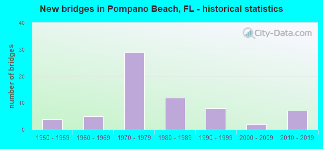
- New bridges - historical statistics
- 41950-1959
- 51960-1969
- 291970-1979
- 121980-1989
- 81990-1999
- 22000-2009
- 72010-2019
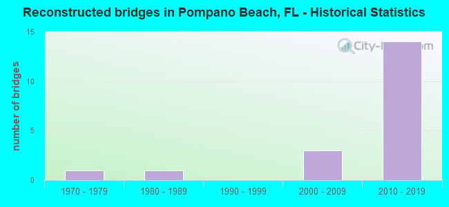
- Reconstructed bridges - Historical Statistics
- 11970-1979
- 11980-1989
- 01990-1999
- 32000-2009
- 142010-2019
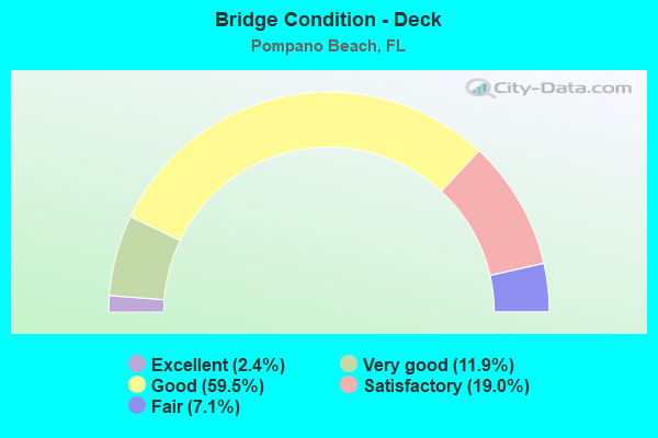
- Bridge Condition - Deck
- 2.4%Excellent
- 11.9%Very good
- 59.5%Good
- 19.0%Satisfactory
- 7.1%Fair
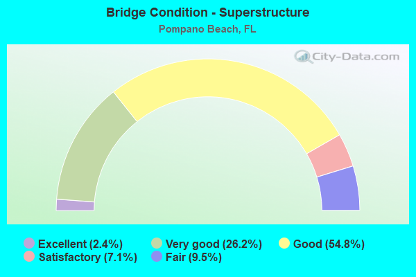
- Bridge Condition - Superstructure
- 2.4%Excellent
- 26.2%Very good
- 54.8%Good
- 7.1%Satisfactory
- 9.5%Fair
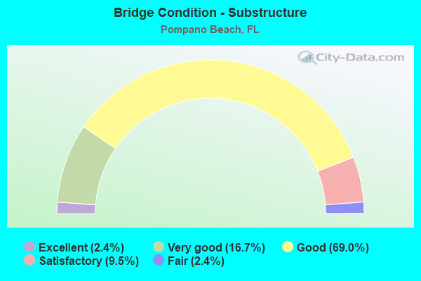
- Bridge Condition - Substructure
- 2.4%Excellent
- 16.7%Very good
- 69.0%Good
- 9.5%Satisfactory
- 2.4%Fair
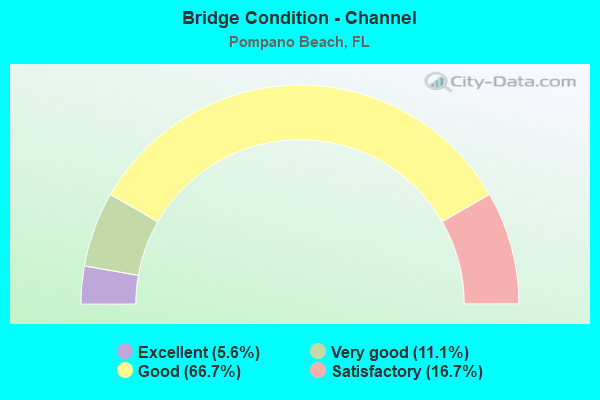
- Bridge Condition - Channel
- 5.6%Excellent
- 11.1%Very good
- 66.7%Good
- 16.7%Satisfactory
Find on map >> Show street view
Structure Number: 868116, Location: 0.5 MI. N. of SE15th St. (Lat: 26.218800, Lng: -80.109506), Route carried "on" structure: ServiceCity street , Year Built: 2015, Status: Open, Structure Length: 0.76m (2.49ft), Average Daily Traffic: 400 (year 2021), Average Future Daily Traffic: 694 (year 2042), Design Load: HL 93, Features Intersected: Charles Waterway, Facility Carried by Structure: SE 9th Ave.
Minimum Vertical Clearance: 30+ m (98+ ft), Kilometerpoint: 0.000, Lanes on structure: 2, Owner: City or Municipal Highway Agency, Approaching Roadway Width: 6.4m (21.0ft), Material/Design: Concrete, Design/Construction: Slab, Number Of Spans In Main Unit: 1, Length of Maximum Span: 7.6m (24.9ft), Curb or Sidewalk Widths: Left: 0.5m (1.6ft), Right: 1.5m (4.9ft), Curb-To-Curb Width: 6.4m (21.0ft), Out-to-Out Width: 13.7m (44.9ft)
Condition: Deck: Very good, Superstructure: Very good, Substructure: Very good, Channel: Very good, Operating Rating: 50.3 metric tons, Method Used To Determine Operating Rating: Load and Resistance Factor (LRFR), Inventory Rating: 38.8 metric tons, Method Used To Determine Inventory Rating: Load and Resistance Factor (LRFR), Structural Evaluation: Equal to present desirable criteria, Deck Geometry: Meets minimum limits, Waterway Adequacy: Equal to present desirable criteria, Approach Roadway Alignment: Better than present minimum criteria, Designated Inspection Frequency: Every 24 months, Underwater Inspection Frequency: Every 24 months, Inspection Date: March 2021, Underwater Inspection Date: March 2021, Deck Structure Type: Concrete Cast-file-Place
Find on map >> Show street view
Structure Number: 860011, Location: .8mi North of SR 844 (Lat: 26.261444, Lng: -80.083167), Route carried "under" structure: ServiceCity street , Year Built: 1966, Structure Length: 0. m, Average Daily Traffic: 93 (year 2019), Truck Traffic: 5%, Features Intersected: Hillsboro Inlet, Facility Carried by Structure: SR-A1A
Minimum Vertical Clearance: 2.80m (9.19ft), Kilometerpoint: 0.000, Lanes on structure: 2, Lanes under structure: 1, Material/Design: Steel, Design/Construction: Movable - Bascule, Length of Maximum Span: 22.7m (74.5ft)
Find on map >> Show street view
Structure Number: 860119, Location: 1mi. N of Atlantic Blvd. (Lat: 26.245750, Lng: -80.136722), Route carried "under" structure: County highway , Year Built: 1972, Structure Length: 0. m, Average Daily Traffic: 8,900 (year 2020), Truck Traffic: 9%, Features Intersected: NW 15th St., Facility Carried by Structure: SB I-95 (SR-9)
Minimum Vertical Clearance: 5.15m (16.90ft), Kilometerpoint: 1.477, Lanes on structure: 5, Lanes under structure: 2, Material/Design: Prestressed concrete, Design/Construction: Stringer/Multi-beam, Length of Maximum Span: 27.9m (91.5ft)
Find on map >> Show street view
Structure Number: 86012, Location: 2 mi. N of Atlantic Blvd. (Lat: 26.260519, Lng: -80.133278), Route carried "under" structure: City street , Year Built: 1972, Structure Length: 0. m, Average Daily Traffic: 51,500 (year 2020), Truck Traffic: 7%, Features Intersected: Copans Road, Facility Carried by Structure: I-95 SB (SR-9)
Minimum Vertical Clearance: 4.79m (15.72ft), Kilometerpoint: 1.819, Lanes on structure: 6, Lanes under structure: 7, Material/Design: Prestressed concrete, Design/Construction: Stringer/Multi-beam, Length of Maximum Span: 29.0m (95.1ft)
Find on map >> Show street view
Structure Number: 860121, Location: 1.0 Mi N of Copans Rd. (Lat: 26.274928, Lng: -80.125164), Route carried "under" structure: State highway 834, Year Built: 1974, Structure Length: 0. m, Average Daily Traffic: 62,000 (year 2020), Truck Traffic: 7%, Features Intersected: SR-834 (Sample Road), Facility Carried by Structure: SB I-95 (SR-9)
Minimum Vertical Clearance: 4.66m (15.29ft), Kilometerpoint: 12.495, Lanes on structure: 6, Lanes under structure: 8, Material/Design: Prestressed concrete, Design/Construction: Stringer/Multi-beam, Length of Maximum Span: 22.6m (74.1ft)
Find on map >> Show street view
Structure Number: 860178, Location: 1.0 Mi. N of Copans Rd. (Lat: 26.274956, Lng: -80.124925), Route carried "under" structure: State highway 834, Year Built: 1974, Structure Length: 0. m, Average Daily Traffic: 62,000 (year 2020), Truck Traffic: 7%, Features Intersected: SR-834 (Sample Rd.), Facility Carried by Structure: NB I-95 (SR-9)
Minimum Vertical Clearance: 4.60m (15.09ft), Kilometerpoint: 12.527, Lanes on structure: 6, Lanes under structure: 8, Material/Design: Prestressed concrete, Design/Construction: Stringer/Multi-beam, Length of Maximum Span: 22.6m (74.1ft)
Find on map >> Show street view
Structure Number: 860219, Location: 1mi. N of Atlantic Blvd. (Lat: 26.245750, Lng: -80.136444), Route carried "under" structure: County highway , Year Built: 1972, Structure Length: 0. m, Average Daily Traffic: 8,900 (year 2020), Truck Traffic: 9%, Features Intersected: NW 15th Street, Facility Carried by Structure: NB I-95 (SR-9)
Minimum Vertical Clearance: 5.21m (17.09ft), Kilometerpoint: 1.505, Lanes on structure: 5, Lanes under structure: 2, Material/Design: Prestressed concrete, Design/Construction: Stringer/Multi-beam, Length of Maximum Span: 27.9m (91.5ft)
Find on map >> Show street view
Structure Number: 86022, Location: 2 mi. N of Atlantic Blvd. (Lat: 26.260519, Lng: -80.132967), Route carried "under" structure: City street , Year Built: 1972, Structure Length: 0. m, Average Daily Traffic: 51,500 (year 2020), Truck Traffic: 7%, Features Intersected: Copans Rd., Facility Carried by Structure: I-95 NB (SR-9)
Minimum Vertical Clearance: 4.79m (15.72ft), Kilometerpoint: 1.851, Lanes on structure: 6, Lanes under structure: 7, Material/Design: Prestressed concrete, Design/Construction: Stringer/Multi-beam, Length of Maximum Span: 29.0m (95.1ft)
Find on map >> Show street view
Structure Number: 860231, Location: 2.0 Mi South of Copans Rd (Lat: 26.231517, Lng: -80.136567), Route carried "under" structure: State highway 814, Year Built: 1975, Structure Length: 0. m, Average Daily Traffic: 60,000 (year 2019), Truck Traffic: 5%, Features Intersected: SR-814 (Atlantic Blvd.), Facility Carried by Structure: SB I-95 (SR-9)
Minimum Vertical Clearance: 4.64m (15.22ft), Kilometerpoint: 8.089, Lanes on structure: 5, Lanes under structure: 8, Material/Design: Prestressed concrete, Design/Construction: Stringer/Multi-beam, Length of Maximum Span: 22.4m (73.5ft)
Find on map >> Show street view
Structure Number: 860232, Location: 2.0 Mi South of COPANS RD (Lat: 26.231514, Lng: -80.136344), Route carried "under" structure: State highway 814, Year Built: 1975, Structure Length: 0. m, Average Daily Traffic: 55,500 (year 2020), Truck Traffic: 5%, Features Intersected: SR-814 (Atlantic Blvd.), Facility Carried by Structure: NB I-95 (SR-9)
Minimum Vertical Clearance: 4.79m (15.72ft), Kilometerpoint: 8.114, Lanes on structure: 5, Lanes under structure: 8, Material/Design: Prestressed concrete, Design/Construction: Stringer/Multi-beam, Length of Maximum Span: 22.4m (73.5ft)
Find on map >> Show street view
Structure Number: 860233, Location: 1.2 Mi E of Powerline Rd (Lat: 26.226608, Lng: -80.136389), Route carried "under" structure: Interstate 95, Year Built: 1975, Structure Length: 0. m, Average Daily Traffic: 210,000 (year 2020), Truck Traffic: 8%, Features Intersected: I-95(SR-9), Facility Carried by Structure: SW 3rd St.
Minimum Vertical Clearance: 4.88m (16.01ft), Kilometerpoint: 29.029, Lanes on structure: 6, Lanes under structure: 12, Material/Design: Prestressed concrete, Design/Construction: Stringer/Multi-beam, Length of Maximum Span: 34.7m (113.8ft)
Find on map >> Show street view
Structure Number: 860235, Location: 0.2mi N of Atlantic Blvd. (Lat: 26.234278, Lng: -80.136647), Route carried "under" structure: Business City street , Year Built: 1975, Structure Length: 0. m, Average Daily Traffic: 12,000 (year 2020), Truck Traffic: 9%, Features Intersected: Hammonville/MLK Blvd., Facility Carried by Structure: SB I-95 (SR-9)
Minimum Vertical Clearance: 5.13m (16.83ft), Kilometerpoint: 3.169, Lanes on structure: 5, Lanes under structure: 5, Material/Design: Prestressed concrete, Design/Construction: Stringer/Multi-beam, Length of Maximum Span: 28.4m (93.2ft)
Find on map >> Show street view
Structure Number: 860236, Location: 0.2mi N of Atlantic Blvd. (Lat: 26.234194, Lng: -80.136306), Route carried "under" structure: City street , Year Built: 1975, Structure Length: 0. m, Average Daily Traffic: 12,000 (year 2020), Truck Traffic: 9%, Features Intersected: Hammonville/MLK Blvd, Facility Carried by Structure: NB I-95 (SR-9)
Minimum Vertical Clearance: 5.88m (19.29ft), Kilometerpoint: 3.183, Lanes on structure: 7, Lanes under structure: 5, Material/Design: Prestressed concrete, Design/Construction: Stringer/Multi-beam, Length of Maximum Span: 28.4m (93.2ft)
Find on map >> Show street view
Structure Number: 860241, Location: 0.6mi. N of Cypress Ck Rd (Lat: 26.210628, Lng: -80.137425), Route carried "under" structure: City street , Year Built: 1976, Structure Length: 0. m, Average Daily Traffic: 8,700 (year 2020), Truck Traffic: 9%, Features Intersected: Mc Nab Rd., Facility Carried by Structure: I-95 (SR-9) SB
Minimum Vertical Clearance: 5.70m (18.70ft), Kilometerpoint: 5.071, Lanes on structure: 5, Lanes under structure: 6, Material/Design: Prestressed concrete, Design/Construction: Stringer/Multi-beam, Length of Maximum Span: 29.6m (97.1ft)
Find on map >> Show street view
Structure Number: 860242, Location: 1mi. So. of Atlantic Blvd (Lat: 26.210611, Lng: -80.137167), Route carried "under" structure: City street , Year Built: 1976, Structure Length: 0. m, Average Daily Traffic: 11,600 (year 2019), Truck Traffic: 5%, Features Intersected: Mc Nab Rd., Facility Carried by Structure: I-95 (SR-9) NB
Minimum Vertical Clearance: 5.79m (19.00ft), Kilometerpoint: 5.071, Lanes on structure: 5, Lanes under structure: 6, Material/Design: Prestressed concrete, Design/Construction: Stringer/Multi-beam, Length of Maximum Span: 29.6m (97.1ft)
Find on map >> Show street view
Structure Number: 860372, Location: 0.5 MI. SO. OF SAMPLE RD (Lat: 26.259897, Lng: -80.167367), Route carried "under" structure: Business County highway , Year Built: 1982, Structure Length: 0. m, Average Daily Traffic: 45,850 (year 2021), Truck Traffic: 13%, Features Intersected: COPANS RD, Facility Carried by Structure: SR91 SB TPK 68.38
Minimum Vertical Clearance: 5.43m (17.81ft), Kilometerpoint: 34.046, Lanes on structure: 3, Lanes under structure: 5, Material/Design: Prestressed concrete, Design/Construction: Stringer/Multi-beam, Length of Maximum Span: 26.5m (86.9ft)
Find on map >> Show street view
Structure Number: 860373, Location: 0.5 MI.SO. OF SAMPLE ROAD (Lat: 26.259903, Lng: -80.167192), Route carried "under" structure: Business County highway , Year Built: 1983, Structure Length: 0. m, Average Daily Traffic: 45,850 (year 2021), Truck Traffic: 13%, Features Intersected: COPANS RD, Facility Carried by Structure: SR91 NB TPK 68.37
Minimum Vertical Clearance: 5.15m (16.90ft), Kilometerpoint: 34.038, Lanes on structure: 3, Lanes under structure: 5, Material/Design: Prestressed concrete, Design/Construction: Stringer/Multi-beam, Length of Maximum Span: 26.5m (86.9ft)
Find on map >> Show street view
Structure Number: 860405, Location: 0.1 MI SOUTH OF SAMPLE RD (Lat: 26.270639, Lng: -80.168867), Route carried "under" structure: State highway 91, Year Built: 1984, Structure Length: 0. m, Average Daily Traffic: 91,700 (year 2021), Truck Traffic: 13%, Features Intersected: SR 91 TPK(SAMPLE RD INT)
Minimum Vertical Clearance: 5.39m (17.68ft), Kilometerpoint: 35.258, Lanes on structure: 2, Lanes under structure: 7, Toll: On toll road, Material/Design: Prestressed concrete, Design/Construction: Stringer/Multi-beam, Length of Maximum Span: 24.4m (80.1ft)
Find on map >> Show street view
Structure Number: 860464, Location: S OF POMPANO SERVICE PLAZ (Lat: 26.219053, Lng: -80.188164), Route carried "under" structure: Business City street , Year Built: 1984, Structure Length: 0. m, Average Daily Traffic: 24,000 (year 2021), Truck Traffic: 9%, Features Intersected: NW 31ST AVE, Facility Carried by Structure: SR91 SB TPK 65.11
Minimum Vertical Clearance: 5.18m (16.99ft), Kilometerpoint: 1.833, Lanes on structure: 5, Lanes under structure: 4, Material/Design: Prestressed concrete, Design/Construction: Stringer/Multi-beam, Length of Maximum Span: 30.8m (101.0ft)
Find on map >> Show street view
Structure Number: 860465, Location: S OF POMPANO SERVICE PLAZ (Lat: 26.218631, Lng: -80.188203), Route carried "under" structure: Business City street , Year Built: 1984, Structure Length: 0. m, Average Daily Traffic: 24,000 (year 2021), Truck Traffic: 9%, Features Intersected: NW 31st AVE, Facility Carried by Structure: SR91 NB TPK 65.08
Minimum Vertical Clearance: 5.21m (17.09ft), Kilometerpoint: 1.802, Lanes on structure: 4, Lanes under structure: 4, Material/Design: Prestressed concrete, Design/Construction: Stringer/Multi-beam, Length of Maximum Span: 30.6m (100.4ft)
Find on map >> Show street view
Structure Number: 860587, Location: 2 MILES SOUTH OF SR-834 (Lat: 26.245206, Lng: -80.167486), Route carried "under" structure: State highway 91, Year Built: 1991, Structure Length: 0. m, Average Daily Traffic: 87,800 (year 2021), Truck Traffic: 13%, Features Intersected: SR 91 TPK, Facility Carried by Structure: HMMNDVLL RD 67.348
Minimum Vertical Clearance: 5.52m (18.11ft), Kilometerpoint: 32.399, Lanes on structure: 6, Lanes under structure: 6, Toll: On toll road, Material/Design: Prestressed concrete, Design/Construction: Stringer/Multi-beam, Length of Maximum Span: 26.8m (87.9ft)
Find on map >> Show street view
Structure Number: 860588, Location: 3.8 MI S OF SR-869 (Lat: 26.249128, Lng: -80.166572), Route carried "under" structure: State highway 91, Year Built: 1992, Structure Length: 0. m, Average Daily Traffic: 91,700 (year 2021), Truck Traffic: 13%, Features Intersected: SR 91 TPK (COCO CK INT)
Minimum Vertical Clearance: 5.18m (16.99ft), Kilometerpoint: 32.856, Lanes on structure: 2, Lanes under structure: 7, Toll: On toll road, Material/Design: Prestressed concrete, Design/Construction: Stringer/Multi-beam, Length of Maximum Span: 25.3m (83.0ft)
Find on map >> Show street view
Structure Number: 860636, Location: 0.4Mi N of Atlantic Blvd. (Lat: 26.237583, Lng: -80.142517), Route carried "under" structure: City street NA, Year Built: 2008, Structure Length: 0. m, Average Daily Traffic: 17,000 (year 2020), Truck Traffic: 3%, Features Intersected: DR MLK BLVD & SCL RR, Facility Carried by Structure: Andrews Ave.
Minimum Vertical Clearance: 5.03m (16.50ft), Kilometerpoint: 2.456, Lanes on structure: 4, Lanes under structure: 4, Material/Design: Steel continuous, Design/Construction: Stringer/Multi-beam, Length of Maximum Span: 75.6m (248.0ft)
Find on map >> Show street view
Structure Number: 860683, Location: 2.0 Mi South of Copans Rd (Lat: 26.231583, Lng: -80.136139), Route carried "under" structure: State highway 814, Year Built: 2019, Structure Length: 0. m, Average Daily Traffic: 57,000 (year 2020), Truck Traffic: 5%, Features Intersected: Atlantic Blvd, Facility Carried by Structure: NB I-95 Ent Rmp C
Minimum Vertical Clearance: 5.03m (16.50ft), Kilometerpoint: 8.114, Lanes on structure: 1, Lanes under structure: 8, Material/Design: Prestressed concrete, Design/Construction: Stringer/Multi-beam, Length of Maximum Span: 32.9m (107.9ft)
Find on map >> Show street view
Structure Number: 860684, Location: 2.0 Mi South of Copans Rd (Lat: 26.231583, Lng: -80.136778), Route carried "under" structure: State highway 814, Year Built: 2019, Structure Length: 0. m, Average Daily Traffic: 57,000 (year 2020), Truck Traffic: 5%, Features Intersected: Atlantic Blvd., Facility Carried by Structure: SB I-95 Exit Rmp D
Minimum Vertical Clearance: 5.03m (16.50ft), Kilometerpoint: 8.089, Lanes on structure: 1, Lanes under structure: 8, Material/Design: Prestressed concrete, Design/Construction: Stringer/Multi-beam, Length of Maximum Span: 32.9m (107.9ft)
Find on map >> Show street view
Structure Number: 869903, Location: 0.5 Mi. N of Sample Rd. (Lat: 26.280694, Lng: -80.125139), Route carried "under" structure: Interstate 95, Year Built: 2019, Structure Length: 0. m, Average Daily Traffic: 210,000 (year 2020), Truck Traffic: 8%, Features Intersected: I-95 NB/SB, Facility Carried by Structure: Ped. Overpass
Minimum Vertical Clearance: 5.58m (18.31ft), Kilometerpoint: 35.443, Lanes under structure: 11, Material/Design: Steel, Design/Construction: Truss - Thru, Length of Maximum Span: 39.8m (130.6ft)