Bridge Statistics for Port Huron, Michigan (MI)
Condition, Traffic, Stress, Structural Evaluation, Project Costs
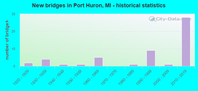
- New bridges - historical statistics
- 21920-1929
- 41930-1939
- 11940-1949
- 11950-1959
- 51960-1969
- 11980-1989
- 91990-1999
- 12000-2009
- 282010-2019
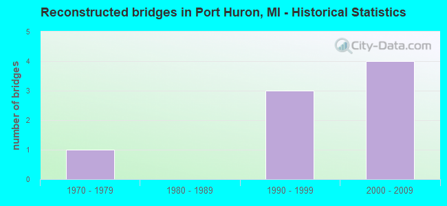
- Reconstructed bridges - Historical Statistics
- 11970-1979
- 01980-1989
- 31990-1999
- 42000-2009
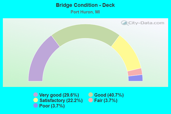
- Bridge Condition - Deck
- 29.6%Very good
- 40.7%Good
- 22.2%Satisfactory
- 3.7%Fair
- 3.7%Poor
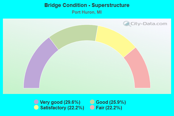
- Bridge Condition - Superstructure
- 29.6%Very good
- 25.9%Good
- 22.2%Satisfactory
- 22.2%Fair
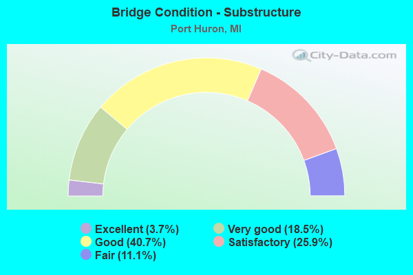
- Bridge Condition - Substructure
- 3.7%Excellent
- 18.5%Very good
- 40.7%Good
- 25.9%Satisfactory
- 11.1%Fair
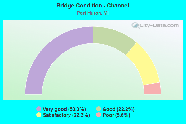
- Bridge Condition - Channel
- 50.0%Very good
- 22.2%Good
- 22.2%Satisfactory
- 5.6%Poor
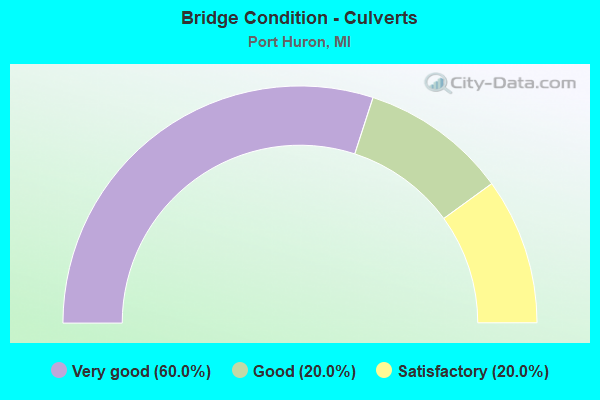
- Bridge Condition - Culverts
- 60.0%Very good
- 20.0%Good
- 20.0%Satisfactory
Find on map >> Show street view
Structure Number: 10111, Location: SEC. 16 PORT HURON TWP. (Lat: 42.961125, Lng: -82.452133), Route carried "under" structure: County highway 1210, Year Built: 1925, Structure Length: 0. m, Average Daily Traffic: 16,020 (year 1989), Features Intersected: 24TH STREET, Facility Carried by Structure: CN-GTC-GTW RR CO.
Minimum Vertical Clearance: 4.16m (13.65ft), Kilometerpoint: 2.203, Lanes under structure: 4, Material/Design: Steel, Design/Construction: Stringer/Multi-beam, Length of Maximum Span: 8.8m (28.9ft)
Find on map >> Show street view
Structure Number: 12762, Location: PORT HURON @ PLAZA (Lat: 42.998544, Lng: -82.439556), Route carried "under" structure: Ramp Interstate 94, Year Built: 1992, Structure Length: 0. m, Average Daily Traffic: 3,500 (year 1995), Truck Traffic: 3%, Features Intersected: EB I-94/I-69 ON RAMP
Minimum Vertical Clearance: 4.67m (15.32ft), Kilometerpoint: 0.220, Lanes on structure: 4, Lanes under structure: 2, Material/Design: Prestressed concrete, Design/Construction: Stringer/Multi-beam, Length of Maximum Span: 28.9m (94.8ft)
Find on map >> Show street view
Structure Number: 12763, Location: PORT HURON @ PLAZA (Lat: 42.998156, Lng: -82.436503), Route carried "under" structure: State highway 25, Year Built: 1993, Structure Length: 0. m, Average Daily Traffic: 21,992 (year 2007), Truck Traffic: 1%, Features Intersected: M-25 PINE GROVE AVE, Facility Carried by Structure: I-94 & I-69
Minimum Vertical Clearance: 4.55m (14.93ft), Kilometerpoint: 2.020, Lanes on structure: 4, Lanes under structure: 4, Material/Design: Prestressed concrete, Design/Construction: Stringer/Multi-beam, Length of Maximum Span: 35.3m (115.8ft)
Find on map >> Show street view
Structure Number: 13534, Location: I-69/I-94 INTERCHANGE (Lat: 42.972889, Lng: -82.490889), Route carried "under" structure: Interstate 69, Year Built: 2015, Structure Length: 0. m, Average Daily Traffic: 13,295 (year 2012), Truck Traffic: 12%, Features Intersected: I-69
Minimum Vertical Clearance: 11.66m (38.25ft), Kilometerpoint: 0.000, Lanes on structure: 1, Lanes under structure: 4, Material/Design: Steel continuous, Design/Construction: Stringer/Multi-beam, Length of Maximum Span: 69.2m (227.0ft)
Find on map >> Show street view
Structure Number: 13579, Location: W CITY LIMITS (Lat: 42.992825, Lng: -82.448272), Route carried "under" structure: City street , Year Built: 2011, Structure Length: 0. m, Average Daily Traffic: 150 (year 0000), Features Intersected: BLACK RIVER & SCOTT AVE, Facility Carried by Structure: PINE GROVE AV CONN
Minimum Vertical Clearance: 4.57m (14.99ft), Kilometerpoint: 0.237, Lanes on structure: 3, Lanes under structure: 2, Material/Design: Prestressed concrete, Design/Construction: Stringer/Multi-beam, Length of Maximum Span: 43.6m (143.0ft)
Find on map >> Show street view
Structure Number: 1358, Location: W CITY LIMITS (Lat: 42.992969, Lng: -82.448519), Route carried "under" structure: City street , Year Built: 2011, Structure Length: 0. m, Average Daily Traffic: 150 (year 0000), Features Intersected: BLACK RIVER & SCOTT AVE, Facility Carried by Structure: I-94 & I-69 EB
Minimum Vertical Clearance: 5.03m (16.50ft), Kilometerpoint: 0.208, Lanes on structure: 3, Lanes under structure: 2, Material/Design: Prestressed concrete, Design/Construction: Stringer/Multi-beam, Length of Maximum Span: 43.6m (143.0ft)
Find on map >> Show street view
Structure Number: 13581, Location: W CITY LIMITS (Lat: 42.995156, Lng: -82.444481), Route carried "under" structure: City street , Year Built: 2011, Structure Length: 0. m, Average Daily Traffic: 150 (year 0000), Features Intersected: BLACK RIVER & SCOTT AVE, Facility Carried by Structure: I-94 & I-69 WB
Minimum Vertical Clearance: 4.90m (16.08ft), Kilometerpoint: 0.200, Lanes on structure: 3, Lanes under structure: 2, Material/Design: Prestressed concrete, Design/Construction: Stringer/Multi-beam, Length of Maximum Span: 43.6m (143.0ft)
Find on map >> Show street view
Structure Number: 13687, Location: I-69, I-94 INTERCHANGE (Lat: 42.974000, Lng: -82.483400), Route carried "under" structure: Interstate 94, Year Built: 2015, Structure Length: 0. m, Average Daily Traffic: 27,633 (year 2012), Truck Traffic: 12%, Features Intersected: I-69, I-94, Facility Carried by Structure: MICHIGAN ROAD
Minimum Vertical Clearance: 5.97m (19.59ft), Kilometerpoint: 35.262, Lanes on structure: 2, Lanes under structure: 6, Material/Design: Steel continuous, Design/Construction: Stringer/Multi-beam, Length of Maximum Span: 36.0m (118.1ft)
Find on map >> Show street view
Structure Number: 13687, Location: I-69, I-94 INTERCHANGE (Lat: 42.974000, Lng: -82.483400), Route carried "under" structure: Interstate 69, Year Built: 2015, Structure Length: 0. m, Average Daily Traffic: 15,544 (year 2012), Truck Traffic: 12%, Features Intersected: I-69, I-94, Facility Carried by Structure: MICHIGAN ROAD
Minimum Vertical Clearance: 5.49m (18.01ft), Kilometerpoint: 42.781, Lanes on structure: 2, Lanes under structure: 6, Material/Design: Steel continuous, Design/Construction: Stringer/Multi-beam, Length of Maximum Span: 36.0m (118.1ft)