Bridge Statistics for Rochester Hills, Michigan (MI)
Condition, Traffic, Stress, Structural Evaluation, Project Costs
- National Bridge Inventory (NBI) Statistics
- 44Number of bridges
- 423ft / 129mTotal length
- $1,262,000Total costs
- 1,041,772Total average daily traffic
- 39,026Total average daily truck traffic
- National Bridge Inventory (NBI) Registered Bridges for Rochester Hills
- No street view available for this location
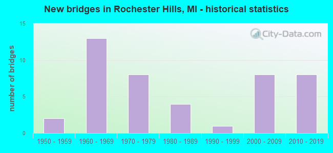
- New bridges - historical statistics
- 21950-1959
- 131960-1969
- 81970-1979
- 41980-1989
- 11990-1999
- 82000-2009
- 82010-2019
- Reconstructed bridges - Historical Statistics
- 11960-1969
- 01970-1979
- 01980-1989
- 31990-1999
- 32000-2009
- 32010-2019
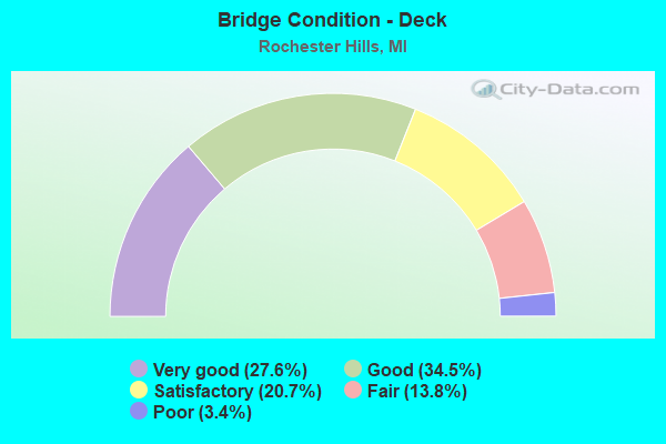
- Bridge Condition - Deck
- 27.6%Very good
- 34.5%Good
- 20.7%Satisfactory
- 13.8%Fair
- 3.4%Poor
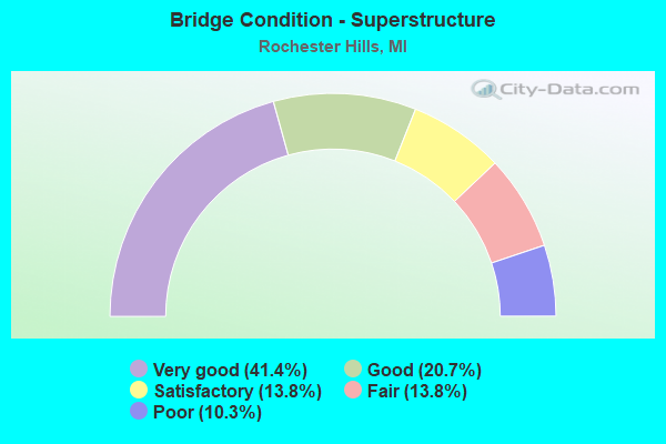
- Bridge Condition - Superstructure
- 41.4%Very good
- 20.7%Good
- 13.8%Satisfactory
- 13.8%Fair
- 10.3%Poor
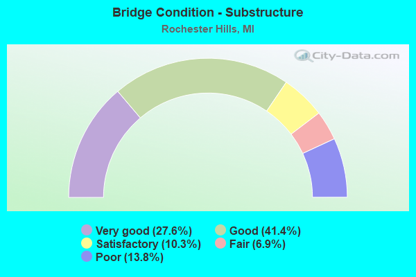
- Bridge Condition - Substructure
- 27.6%Very good
- 41.4%Good
- 10.3%Satisfactory
- 6.9%Fair
- 13.8%Poor
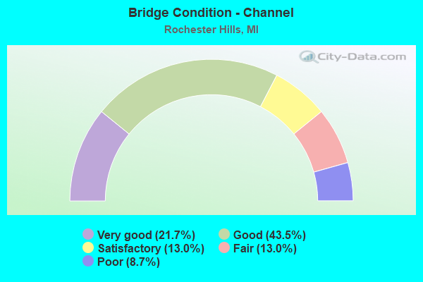
- Bridge Condition - Channel
- 21.7%Very good
- 43.5%Good
- 13.0%Satisfactory
- 13.0%Fair
- 8.7%Poor
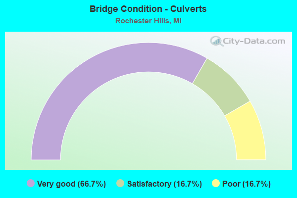
- Bridge Condition - Culverts
- 66.7%Very good
- 16.7%Satisfactory
- 16.7%Poor
Find on map >> Show street view
Structure Number: 828, Location: 3.0 MI S OF BENTON HARBOR (Lat: 42.062456, Lng: -86.448478), Route carried "on" structure: Interstate 94, Year Built: 1960, Year Reconstructed: 1965, Status: Open, Structure Length: 19.63m (64.40ft), Average Daily Traffic: 34,063 (year 2014), Truck Traffic: 19%, Average Future Daily Traffic: 36,163 (year 2035), Design Load: HS 20, Features Intersected: ST JOSEPH RIVER
Minimum Vertical Clearance: 30.48m (100.00ft), Kilometerpoint: 44.312, Lanes on structure: 3, Base Highway Network: Yes (Inventory Route: 136, Subroute: 2), Owner: State Highway Agency, Approaching Roadway Width: 14.1m (46.3ft), Skew: 1 degrees, Navigation Control: Yes ( Vertical Clearance: 6.0m (19.7ft), Horizontal Clearance: 24.0m (78.7ft)), Material/Design: Steel, Design/Construction: Stringer/Multi-beam, Number Of Spans In Main Unit: 8, Length of Maximum Span: 25.6m (84.0ft), Curb-To-Curb Width: 14.3m (46.9ft), Out-to-Out Width: 15.2m (49.9ft)
Condition: Deck: Satisfactory, Superstructure: Fair, Substructure: Satisfactory, Channel: Satisfactory, Operating Rating: 75.5 metric tons, Method Used To Determine Operating Rating: Load Factor (LF) rating reported by rating factor (RF) method using MS18 loading, Inventory Rating: 45.0 metric tons, Method Used To Determine Inventory Rating: Load Factor (LF) rating reported by rating factor (RF) method using MS18 loading, Structural Evaluation: Somewhat better than minimum adequacy, Deck Geometry: Meets minimum limits, Waterway Adequacy: Equal to present desirable criteria, Approach Roadway Alignment: Equal to present minimum criteria, Designated Inspection Frequency: Every 24 months, Underwater Inspection Frequency: Every 60 months, Inspection Date: July 2020, Underwater Inspection Date: June 2017, Deck Structure Type: Concrete Cast-file-Place, Wearing Surface/Protective System: Wearing Surface: Epoxy Overlay
Find on map >> Show street view
Structure Number: 6404, Location: 0.5 MI WEST OF MOUND RD (Lat: 42.742017, Lng: -83.067692), Route carried "on" structure: County highway , Year Built: 1961, Year Reconstructed: 2017, Status: Open, Structure Length: 1.22m (4.00ft), Average Daily Traffic: 3,400 (year 2017), Truck Traffic: 1%, Average Future Daily Traffic: 3,800 (year 2037), Design Load: Greater than HL93, Features Intersected: STONY CREEK, Facility Carried by Structure: 28 MILE ROAD
Minimum Vertical Clearance: 30.48m (100.00ft), Kilometerpoint: 2.377, Lanes on structure: 2, Owner: County Highway Agency, Approaching Roadway Width: 8.6m (28.2ft), Material/Design: Prestressed concrete, Design/Construction: Box Beam or Girders - Multiple, Number Of Spans In Main Unit: 1, Length of Maximum Span: 11.8m (38.7ft), Curb-To-Curb Width: 8.6m (28.2ft), Out-to-Out Width: 9.5m (31.2ft)
Condition: Deck: Very good, Superstructure: Very good, Substructure: Very good, Channel: Very good, Operating Rating: 84.6 metric tons, Method Used To Determine Operating Rating: Load and Resistance Factor Rating (LRFR) rating reported by rating factor(RF) method using HL-93 loadings, Inventory Rating: 65.1 metric tons, Method Used To Determine Inventory Rating: Load and Resistance Factor Rating (LRFR) rating reported by rating factor(RF) method using HL-93 loadings, Structural Evaluation: Equal to present desirable criteria, Deck Geometry: Meets minimum limits, Waterway Adequacy: Equal to present desirable criteria, Approach Roadway Alignment: Equal to present desirable criteria, Designated Inspection Frequency: Every 24 months, Underwater Inspection Frequency: Every 60 months, Inspection Date: October 2021, Underwater Inspection Date: August 2018, Deck Structure Type: Concrete Cast-file-Place, Wearing Surface/Protective System: Wearing Surface: Monolithic Concrete, Deck Protection: Epoxy Coated Reinforcing
Find on map >> Show street view
Structure Number: 6405, Location: 0.6 MI EAST OF MT VERNON (Lat: 42.763578, Lng: -83.074447), Route carried "on" structure: County highway , Year Built: 1960, Status: Posted for load, Structure Length: 0.88m (2.89ft), Average Daily Traffic: 110 (year 2009), Truck Traffic: 2%, Average Future Daily Traffic: 163 (year 2029), Design Load: H 20, Features Intersected: STONY CREEK, Facility Carried by Structure: INWOOD ROAD
Minimum Vertical Clearance: 30.48m (100.00ft), Kilometerpoint: 1.897, Lanes on structure: 2, Owner: County Highway Agency, Approaching Roadway Width: 10.0m (32.8ft), Material/Design: Steel, Design/Construction: Culvert, Number Of Spans In Main Unit: 2, Length of Maximum Span: 3.9m (12.8ft)
Condition: Channel: Satisfactory, Culverts: Poor, Operating Rating: 15.6 metric tons, Method Used To Determine Operating Rating: Load Factor (LF) rating reported by rating factor (RF) method using MS18 loading, Inventory Rating: 9.4 metric tons, Method Used To Determine Inventory Rating: Load Factor (LF) rating reported by rating factor (RF) method using MS18 loading, Structural Evaluation: High priority of corrective action, Waterway Adequacy: Better than present minimum criteria, Approach Roadway Alignment: Equal to present desirable criteria, Bridge Posting: Required (Relationship of Operating Rating to Maximum Legal Load: > 39.9% below), Designated Inspection Frequency: Every 12 months, Inspection Date: July 2021
Find on map >> Show street view
Structure Number: 6409, Location: 0.25 MI NORTH OF 26 MILE (Lat: 42.715447, Lng: -83.091792), Route carried "on" structure: County highway , Year Built: 2016, Status: Open, Structure Length: 1.37m (4.49ft), Average Daily Traffic: 121 (year 2003), Truck Traffic: 3%, Average Future Daily Traffic: 133 (year 2023), Design Load: HL 93, Features Intersected: STONY CREEK, Facility Carried by Structure: MT VERNON RD
Minimum Vertical Clearance: 30.48m (100.00ft), Kilometerpoint: 0.850, Lanes on structure: 2, Owner: County Highway Agency, Approaching Roadway Width: 5.1m (16.7ft), Material/Design: Steel, Design/Construction: Girder and Floorbeam System, Number Of Spans In Main Unit: 1, Length of Maximum Span: 13.4m (44.0ft), Curb-To-Curb Width: 5.5m (18.0ft), Out-to-Out Width: 5.5m (18.0ft)
Condition: Deck: Very good, Superstructure: Very good, Substructure: Very good, Channel: Good, Operating Rating: 62.9 metric tons, Method Used To Determine Operating Rating: Load and Resistance Factor Rating (LRFR) rating reported by rating factor(RF) method using HL-93 loadings, Inventory Rating: 48.6 metric tons, Method Used To Determine Inventory Rating: Load and Resistance Factor Rating (LRFR) rating reported by rating factor(RF) method using HL-93 loadings, Structural Evaluation: Equal to present desirable criteria, Waterway Adequacy: Better than present minimum criteria, Approach Roadway Alignment: Somewhat better than minimum adequacy, Designated Inspection Frequency: Every 24 months, Inspection Date: October 2020, Deck Structure Type: Steel plate, Wearing Surface/Protective System: Wearing Surface: Epoxy Overlay
Find on map >> Show street view
Structure Number: 7837, Location: 2.5 MI E OF I-75 (Lat: 42.644136, Lng: -83.189339), Route carried "on" structure: State highway 59, Year Built: 1966, Year Reconstructed: 2010, Status: Open, Structure Length: 6.18m (20.28ft), Average Daily Traffic: 39,243 (year 2007), Truck Traffic: 3%, Average Future Daily Traffic: 47,982 (year 2018), Design Load: HS 25 or greater, Features Intersected: CLINTON RIVER TRAIL
Minimum Vertical Clearance: 30.48m (100.00ft), Kilometerpoint: 42.445, Lanes on structure: 3, Base Highway Network: Yes (Inventory Route: 64, Subroute: 6), Owner: State Highway Agency, Approaching Roadway Width: 21.0m (68.9ft), Skew: 4 degrees, Material/Design: Steel, Design/Construction: Stringer/Multi-beam, Number Of Spans In Main Unit: 3, Length of Maximum Span: 23.0m (75.5ft), Curb-To-Curb Width: 19.8m (65.0ft), Out-to-Out Width: 20.8m (68.2ft)
Condition: Deck: Fair, Superstructure: Satisfactory, Substructure: Satisfactory, Operating Rating: 70.0 metric tons, Method Used To Determine Operating Rating: Load Factor (LF) rating reported by rating factor (RF) method using MS18 loading, Inventory Rating: 42.1 metric tons, Method Used To Determine Inventory Rating: Load Factor (LF) rating reported by rating factor (RF) method using MS18 loading, Structural Evaluation: Equal to present minimum criteria, Deck Geometry: Superior to present desirable criteria, Approach Roadway Alignment: Equal to present desirable criteria, Designated Inspection Frequency: Every 24 months, Inspection Date: May 2021, Deck Structure Type: Concrete Cast-file-Place, Wearing Surface/Protective System: Wearing Surface: Latex Concrete, Deck Protection: Epoxy Coated Reinforcing
Find on map >> Show street view
Structure Number: 7838, Location: 2.5 MI E OF I-75 (Lat: 42.644286, Lng: -83.188853), Route carried "on" structure: State highway 59, Year Built: 1967, Year Reconstructed: 2010, Status: Open, Structure Length: 6.20m (20.34ft), Average Daily Traffic: 39,243 (year 2007), Truck Traffic: 3%, Average Future Daily Traffic: 47,982 (year 2018), Design Load: HS 25 or greater, Features Intersected: CLINTON RIVER TRAIL
Minimum Vertical Clearance: 30.48m (100.00ft), Kilometerpoint: 7.809, Lanes on structure: 3, Base Highway Network: Yes (Inventory Route: 67, Subroute: 8), Owner: State Highway Agency, Approaching Roadway Width: 21.0m (68.9ft), Skew: 4 degrees, Material/Design: Steel, Design/Construction: Stringer/Multi-beam, Number Of Spans In Main Unit: 3, Length of Maximum Span: 23.0m (75.5ft), Curb-To-Curb Width: 19.8m (65.0ft), Out-to-Out Width: 20.9m (68.6ft)
Condition: Deck: Satisfactory, Superstructure: Fair, Substructure: Good, Operating Rating: 63.8 metric tons, Method Used To Determine Operating Rating: Load Factor (LF) rating reported by rating factor (RF) method using MS18 loading, Inventory Rating: 38.2 metric tons, Method Used To Determine Inventory Rating: Load Factor (LF) rating reported by rating factor (RF) method using MS18 loading, Structural Evaluation: Somewhat better than minimum adequacy, Deck Geometry: Superior to present desirable criteria, Approach Roadway Alignment: Equal to present desirable criteria, Designated Inspection Frequency: Every 24 months, Inspection Date: May 2021, Deck Structure Type: Concrete Cast-file-Place, Wearing Surface/Protective System: Wearing Surface: Latex Concrete, Deck Protection: Epoxy Coated Reinforcing
Find on map >> Show street view
Structure Number: 7843, Location: 3.4 MI E OF I-75 (Lat: 42.644436, Lng: -83.170836), Route carried "on" structure: County highway 2059, Year Built: 2011, Status: Open, Structure Length: 6.61m (21.69ft), Average Daily Traffic: 21,645 (year 2011), Truck Traffic: 3%, Average Future Daily Traffic: 22,800 (year 2015), Design Load: Greater than HL93, Features Intersected: M-59, Facility Carried by Structure: CROOKS RD
Minimum Vertical Clearance: 30.48m (100.00ft), Kilometerpoint: 16.749, Lanes on structure: 2, Lanes under structure: 6, Base Highway Network: Yes (Inventory Route: 65, Subroute: 10), Owner: State Highway Agency, Approaching Roadway Width: 15.8m (51.8ft), Material/Design: Prestressed concrete, Design/Construction: Stringer/Multi-beam, Number Of Spans In Main Unit: 2, Length of Maximum Span: 32.2m (105.6ft), Curb or Sidewalk Widths: Left: 3.7m (12.1ft), Right: 3.7m (12.1ft), Curb-To-Curb Width: 17.1m (56.1ft), Out-to-Out Width: 26.0m (85.3ft)
Condition: Deck: Good, Superstructure: Very good, Substructure: Very good, Operating Rating: 47.3 metric tons, Method Used To Determine Operating Rating: Load and Resistance Factor Rating (LRFR) rating reported by rating factor(RF) method using HL-93 loadings, Inventory Rating: 27.2 metric tons, Method Used To Determine Inventory Rating: Load and Resistance Factor Rating (LRFR) rating reported by rating factor(RF) method using HL-93 loadings, Structural Evaluation: Equal to present minimum criteria, Deck Geometry: Superior to present desirable criteria, Underclear: Somewhat better than minimum adequacy, Approach Roadway Alignment: Equal to present desirable criteria, Designated Inspection Frequency: Every 24 months, Inspection Date: September 2020, Deck Structure Type: Concrete Cast-file-Place, Wearing Surface/Protective System: Wearing Surface: Monolithic Concrete, Deck Protection: Epoxy Coated Reinforcing
Find on map >> Show street view
Structure Number: 7844, Location: 4.4 MI E OF I-75 (Lat: 42.641686, Lng: -83.152353), Route carried "on" structure: County highway 2059, Year Built: 1966, Status: Open, Structure Length: 8.57m (28.12ft), Average Daily Traffic: 18,303 (year 1996), Truck Traffic: 3%, Average Future Daily Traffic: 21,300 (year 2015), Design Load: H 20, Features Intersected: M-59, Facility Carried by Structure: LIVERNOIS RD
Minimum Vertical Clearance: 30.48m (100.00ft), Kilometerpoint: 10.385, Lanes on structure: 2, Lanes under structure: 4, Owner: State Highway Agency, Approaching Roadway Width: 10.3m (33.8ft), Skew: 4 degrees, Material/Design: Steel, Design/Construction: Stringer/Multi-beam, Number Of Spans In Main Unit: 4, Length of Maximum Span: 29.9m (98.1ft), Curb-To-Curb Width: 9.7m (31.8ft), Out-to-Out Width: 10.7m (35.1ft)
Condition: Deck: Good, Superstructure: Good, Substructure: Good, Operating Rating: 67.8 metric tons, Method Used To Determine Operating Rating: Load Factor (LF), Inventory Rating: 40.6 metric tons, Method Used To Determine Inventory Rating: Load Factor (LF), Structural Evaluation: Better than present minimum criteria, Deck Geometry: Meets minimum limits, Underclear: High priority of corrective action, Approach Roadway Alignment: Equal to present desirable criteria, Designated Inspection Frequency: Every 24 months, Inspection Date: May 2021, Deck Structure Type: Concrete Cast-file-Place, Wearing Surface/Protective System: Wearing Surface: Latex Concrete
Find on map >> Show street view
Structure Number: 7845, Location: 1.0 MI W OF M-150 (Lat: 42.635733, Lng: -83.145497), Route carried "on" structure: City street , Year Built: 1972, Year Reconstructed: 2009, Status: Open, Structure Length: 9.54m (31.30ft), Average Daily Traffic: 13,146 (year 2007), Truck Traffic: 3%, Average Future Daily Traffic: 58,967 (year 2018), Design Load: HS 20, Features Intersected: M-59, Facility Carried by Structure: AUBURN RD
Minimum Vertical Clearance: 30.48m (100.00ft), Kilometerpoint: 11.943, Lanes on structure: 2, Lanes under structure: 4, Owner: State Highway Agency, Approaching Roadway Width: 18.2m (59.7ft), Skew: 3 degrees, Material/Design: Steel, Design/Construction: Stringer/Multi-beam, Number Of Spans In Main Unit: 4, Length of Maximum Span: 34.7m (113.8ft), Curb-To-Curb Width: 14.8m (48.6ft), Out-to-Out Width: 16.0m (52.5ft)
Condition: Deck: Good, Superstructure: Very good, Substructure: Good, Operating Rating: 70.5 metric tons, Method Used To Determine Operating Rating: Load Factor (LF), Inventory Rating: 42.3 metric tons, Method Used To Determine Inventory Rating: Load Factor (LF), Structural Evaluation: Better than present minimum criteria, Deck Geometry: Superior to present desirable criteria, Underclear: High priority of corrective action, Approach Roadway Alignment: Equal to present desirable criteria, Designated Inspection Frequency: Every 24 months, Inspection Date: May 2021, Bridge Improvement Cost: $701,000, Roadway Improvement Cost: $66,000, Total Project Cost: $775,000, Deck Structure Type: Concrete Cast-file-Place, Wearing Surface/Protective System: Wearing Surface: Latex Concrete
Find on map >> Show street view
Structure Number: 7846, Location: @ M-150 (Lat: 42.628256, Lng: -83.131331), Route carried "on" structure: State highway 150, Year Built: 1970, Status: Open, Structure Length: 9.96m (32.68ft), Average Daily Traffic: 35,094 (year 2007), Truck Traffic: 10%, Average Future Daily Traffic: 26,104 (year 2018), Design Load: HS 20, Features Intersected: M-59
Minimum Vertical Clearance: 30.48m (100.00ft), Kilometerpoint: 14.749, Lanes on structure: 4, Lanes under structure: 6, Base Highway Network: Yes (Inventory Route: 441, Subroute: 38), Owner: State Highway Agency, Approaching Roadway Width: 28.0m (91.9ft), Skew: 32 degrees, Material/Design: Steel, Design/Construction: Stringer/Multi-beam, Number Of Spans In Main Unit: 4, Length of Maximum Span: 31.1m (102.0ft), Curb or Sidewalk Widths: Left: 0.2m (0.7ft), Right: 0.2m (0.7ft), Curb-To-Curb Width: 22.1m (72.5ft), Out-to-Out Width: 25.7m (84.3ft)
Condition: Deck: Satisfactory, Superstructure: Satisfactory, Substructure: Fair, Operating Rating: 65.3 metric tons, Method Used To Determine Operating Rating: Load Factor (LF), Inventory Rating: 39.2 metric tons, Method Used To Determine Inventory Rating: Load Factor (LF), Structural Evaluation: Somewhat better than minimum adequacy, Deck Geometry: Superior to present desirable criteria, Underclear: Meets minimum limits, Approach Roadway Alignment: Equal to present desirable criteria, Designated Inspection Frequency: Every 24 months, Inspection Date: August 2020, Bridge Improvement Cost: $810,000, Deck Structure Type: Concrete Cast-file-Place, Wearing Surface/Protective System: Wearing Surface: Latex Concrete
Find on map >> Show street view
Structure Number: 7847, Location: 4.0 MI W OF UTICA (Lat: 42.624833, Lng: -83.111139), Route carried "on" structure: State highway 59, Year Built: 1972, Year Reconstructed: 2009, Status: Open, Structure Length: 3.61m (11.84ft), Average Daily Traffic: 42,820 (year 2007), Truck Traffic: 3%, Average Future Daily Traffic: 65,390 (year 2035), Design Load: HS 20, Features Intersected: JOHN R RD
Minimum Vertical Clearance: 30.48m (100.00ft), Kilometerpoint: 49.631, Lanes on structure: 2, Lanes under structure: 2, Base Highway Network: Yes (Inventory Route: 64, Subroute: 6), Owner: State Highway Agency, Approaching Roadway Width: 12.8m (42.0ft), Material/Design: Steel, Design/Construction: Stringer/Multi-beam, Number Of Spans In Main Unit: 1, Length of Maximum Span: 36.1m (118.4ft), Curb-To-Curb Width: 19.9m (65.3ft), Out-to-Out Width: 20.9m (68.6ft)
Condition: Deck: Very good, Superstructure: Very good, Substructure: Good, Inventory Rating: 76.6 metric tons, Method Used To Determine Inventory Rating: Load Factor (LF), Structural Evaluation: Better than present minimum criteria, Deck Geometry: Superior to present desirable criteria, Underclear: Equal to present minimum criteria, Approach Roadway Alignment: Equal to present desirable criteria, Designated Inspection Frequency: Every 24 months, Inspection Date: May 2021, Deck Structure Type: Concrete Cast-file-Place, Wearing Surface/Protective System: Wearing Surface: Monolithic Concrete, Deck Protection: Epoxy Coated Reinforcing
Find on map >> Show street view
Structure Number: 785, Location: 4.0 MI W OF UTICA (Lat: 42.625047, Lng: -83.111153), Route carried "on" structure: State highway 59, Year Built: 1972, Year Reconstructed: 2009, Status: Open, Structure Length: 3.61m (11.84ft), Average Daily Traffic: 42,820 (year 2007), Truck Traffic: 5%, Average Future Daily Traffic: 65,390 (year 2035), Design Load: HS 20, Features Intersected: JOHN R RD
Minimum Vertical Clearance: 30.48m (100.00ft), Kilometerpoint: 14.953, Lanes on structure: 2, Lanes under structure: 2, Base Highway Network: Yes (Inventory Route: 67, Subroute: 8), Owner: State Highway Agency, Approaching Roadway Width: 12.8m (42.0ft), Material/Design: Steel, Design/Construction: Stringer/Multi-beam, Number Of Spans In Main Unit: 1, Length of Maximum Span: 36.1m (118.4ft), Curb-To-Curb Width: 19.9m (65.3ft), Out-to-Out Width: 20.9m (68.6ft)
Condition: Deck: Very good, Superstructure: Very good, Substructure: Good, Inventory Rating: 77.4 metric tons, Method Used To Determine Inventory Rating: Load Factor (LF), Structural Evaluation: Better than present minimum criteria, Deck Geometry: Superior to present desirable criteria, Underclear: Somewhat better than minimum adequacy, Approach Roadway Alignment: Equal to present desirable criteria, Designated Inspection Frequency: Every 24 months, Inspection Date: May 2021, Deck Structure Type: Concrete Cast-file-Place, Wearing Surface/Protective System: Wearing Surface: Monolithic Concrete, Deck Protection: Epoxy Coated Reinforcing
Find on map >> Show street view
Structure Number: 8151, Location: BET HAMLIN AND AVON RDS (Lat: 42.653675, Lng: -83.192822), Route carried "on" structure: County highway 2059, Year Built: 1959, Status: Open, Structure Length: 1.09m (3.58ft), Average Daily Traffic: 15,351 (year 1991), Truck Traffic: 7%, Average Future Daily Traffic: 19,600 (year 2010), Design Load: HS 20+Mod, Features Intersected: CLINTON RIVER, Facility Carried by Structure: ADAMS ROAD
Minimum Vertical Clearance: 30.48m (100.00ft), Kilometerpoint: 13.941, Lanes on structure: 2, Base Highway Network: Yes (Inventory Route: 441, Subroute: 61), Owner: County Highway Agency, Approaching Roadway Width: 9.7m (31.8ft), Material/Design: Prestressed concrete, Design/Construction: Box Beam or Girders - Multiple, Number Of Spans In Main Unit: 1, Length of Maximum Span: 9.1m (29.9ft), Curb or Sidewalk Widths: Left: 0.2m (0.7ft), Right: 0.2m (0.7ft), Curb-To-Curb Width: 9.1m (29.9ft), Out-to-Out Width: 10.3m (33.8ft)
Condition: Deck: Very good, Superstructure: Fair, Substructure: Fair, Channel: Fair, Operating Rating: 61.2 metric tons, Method Used To Determine Operating Rating: Load Factor (LF) rating reported by rating factor (RF) method using MS18 loading, Inventory Rating: 30.5 metric tons, Method Used To Determine Inventory Rating: Load Factor (LF) rating reported by rating factor (RF) method using MS18 loading, Structural Evaluation: Somewhat better than minimum adequacy, Deck Geometry: High priority of corrective action, Waterway Adequacy: Better than present minimum criteria, Approach Roadway Alignment: Equal to present desirable criteria, Length Of Structure Improvement: 1.52m (4.99ft), Designated Inspection Frequency: Every 24 months, Inspection Date: September 2020, Bridge Improvement Cost: $135,000, Roadway Improvement Cost: $14,000, Total Project Cost: $159,000 ( Estimate for 2050), Deck Structure Type: Other, Wearing Surface/Protective System: Wearing Surface: Bituminous, Membrane: Preformed Fabric
Find on map >> Show street view
Structure Number: 8152, Location: SOUTH OF ORION (Lat: 42.750592, Lng: -83.197283), Route carried "on" structure: County highway 6381, Year Built: 1986, Status: Open, Structure Length: 2.10m (6.89ft), Average Daily Traffic: 7,495 (year 1991), Average Future Daily Traffic: 15,000 (year 2010), Design Load: HS 20+Mod, Features Intersected: PAINT CREEK, Facility Carried by Structure: ADAMS ROAD
Minimum Vertical Clearance: 30.48m (100.00ft), Kilometerpoint: 24.695, Lanes on structure: 2, Owner: County Highway Agency, Approaching Roadway Width: 12.2m (40.0ft), Material/Design: Prestressed concrete, Design/Construction: Stringer/Multi-beam, Number Of Spans In Main Unit: 1, Length of Maximum Span: 20.1m (65.9ft), Curb-To-Curb Width: 12.2m (40.0ft), Out-to-Out Width: 13.2m (43.3ft)
Condition: Deck: Good, Superstructure: Very good, Substructure: Good, Channel: Good, Operating Rating: 78.7 metric tons, Method Used To Determine Operating Rating: Load Factor (LF) rating reported by rating factor (RF) method using MS18 loading, Inventory Rating: 38.9 metric tons, Method Used To Determine Inventory Rating: Load Factor (LF) rating reported by rating factor (RF) method using MS18 loading, Structural Evaluation: Better than present minimum criteria, Deck Geometry: Somewhat better than minimum adequacy, Waterway Adequacy: Equal to present desirable criteria, Approach Roadway Alignment: Equal to present desirable criteria, Designated Inspection Frequency: Every 24 months, Inspection Date: September 2020, Deck Structure Type: Concrete Cast-file-Place, Wearing Surface/Protective System: Wearing Surface: Monolithic Concrete, Deck Protection: Epoxy Coated Reinforcing
Find on map >> Show street view
Structure Number: 8153, Location: BET HAMLIN AND AVON RDS (Lat: 42.651886, Lng: -83.173811), Route carried "on" structure: County highway 2059, Year Built: 1987, Status: Open, Structure Length: 1.58m (5.18ft), Average Daily Traffic: 24,769 (year 2016), Truck Traffic: 7%, Average Future Daily Traffic: 28,484 (year 2036), Design Load: HS 20+Mod, Features Intersected: CLINTON RIVER, Facility Carried by Structure: CROOKS ROAD
Minimum Vertical Clearance: 30.48m (100.00ft), Kilometerpoint: 17.665, Lanes on structure: 3, Base Highway Network: Yes (Inventory Route: 65, Subroute: 10), Owner: County Highway Agency, Approaching Roadway Width: 15.2m (49.9ft), Skew: 1 degrees, Material/Design: Prestressed concrete, Design/Construction: Box Beam or Girders - Multiple, Number Of Spans In Main Unit: 1, Length of Maximum Span: 15.5m (50.9ft), Curb or Sidewalk Widths: Left: 2.4m (7.9ft), Right: 1.5m (4.9ft), Curb-To-Curb Width: 19.5m (64.0ft), Out-to-Out Width: 24.7m (81.0ft)
Condition: Deck: Satisfactory, Superstructure: Good, Substructure: Good, Channel: Good, Operating Rating: 54.4 metric tons, Method Used To Determine Operating Rating: Load Factor (LF) rating reported by rating factor (RF) method using MS18 loading, Inventory Rating: 32.4 metric tons, Method Used To Determine Inventory Rating: Load Factor (LF) rating reported by rating factor (RF) method using MS18 loading, Structural Evaluation: Better than present minimum criteria, Deck Geometry: Superior to present desirable criteria, Waterway Adequacy: Meets minimum limits, Approach Roadway Alignment: Equal to present desirable criteria, Designated Inspection Frequency: Every 24 months, Inspection Date: September 2020, Deck Structure Type: Concrete Cast-file-Place, Wearing Surface/Protective System: Wearing Surface: Monolithic Concrete, Deck Protection: Epoxy Coated Reinforcing
Find on map >> Show street view
Structure Number: 8154, Location: BET ORION AND SILVER BELL (Lat: 42.732256, Lng: -83.164058), Route carried "on" structure: County highway 2059, Year Built: 1989, Status: Open, Structure Length: 1.89m (6.20ft), Average Daily Traffic: 350 (year 1997), Truck Traffic: 5%, Average Future Daily Traffic: 500 (year 2017), Design Load: HS 20+Mod, Features Intersected: PAINT CREEK, Facility Carried by Structure: GALLAGHER RD
Minimum Vertical Clearance: 30.48m (100.00ft), Kilometerpoint: 1.244, Lanes on structure: 2, Owner: County Highway Agency, Approaching Roadway Width: 9.1m (29.9ft), Material/Design: Wood or Timber, Design/Construction: Slab, Number Of Spans In Main Unit: 1, Number Of Approach Spans: 2, Length of Maximum Span: 9.1m (29.9ft), Curb-To-Curb Width: 9.3m (30.5ft), Out-to-Out Width: 9.5m (31.2ft)
Condition: Deck: Satisfactory, Superstructure: Satisfactory, Substructure: Good, Channel: Satisfactory, Operating Rating: 54.0 metric tons, Method Used To Determine Operating Rating: Allowable Stress (AS), Inventory Rating: 38.0 metric tons, Method Used To Determine Inventory Rating: Allowable Stress (AS), Structural Evaluation: Equal to present minimum criteria, Deck Geometry: Equal to present minimum criteria, Waterway Adequacy: Equal to present desirable criteria, Approach Roadway Alignment: Equal to present minimum criteria, Designated Inspection Frequency: Every 24 months, Inspection Date: September 2020, Deck Structure Type: Wood or Timber, Wearing Surface/Protective System: Wearing Surface: Bituminous, Deck Protection: Other
Find on map >> Show street view
Structure Number: 8155, Location: BET SNELL AND COLLINS RDS (Lat: 42.732150, Lng: -83.160647), Route carried "on" structure: County highway 2059, Year Built: 2014, Status: Open, Structure Length: 1.15m (3.77ft), Average Daily Traffic: 8,437 (year 2011), Truck Traffic: 7%, Average Future Daily Traffic: 11,363 (year 2031), Design Load: Greater than HL93, Features Intersected: PAINT CREEK, Facility Carried by Structure: ORION RD
Minimum Vertical Clearance: 30.48m (100.00ft), Kilometerpoint: 4.341, Lanes on structure: 3, Owner: County Highway Agency, Approaching Roadway Width: 13.4m (44.0ft), Skew: 1 degrees, Material/Design: Concrete, Design/Construction: Culvert, Number Of Spans In Main Unit: 1, Length of Maximum Span: 10.7m (35.1ft), Curb or Sidewalk Widths: Left: 4.3m (14.1ft), Right: 0.0m, Curb-To-Curb Width: 14.6m (47.9ft), Out-to-Out Width: 20.2m (66.3ft)
Condition: Channel: Good, Culverts: Very good, Operating Rating: 49.6 metric tons, Method Used To Determine Operating Rating: Load and Resistance Factor Rating (LRFR) rating reported by rating factor(RF) method using HL-93 loadings, Inventory Rating: 38.2 metric tons, Method Used To Determine Inventory Rating: Load and Resistance Factor Rating (LRFR) rating reported by rating factor(RF) method using HL-93 loadings, Structural Evaluation: Equal to present desirable criteria, Deck Geometry: Somewhat better than minimum adequacy, Waterway Adequacy: Superior to present desirable criteria, Approach Roadway Alignment: Equal to present desirable criteria, Designated Inspection Frequency: Every 24 months, Inspection Date: September 2020
Find on map >> Show street view
Structure Number: 8156, Location: AT SNELL RD (Lat: 42.730903, Lng: -83.159436), Route carried "on" structure: County highway 2059, Year Built: 1996, Status: Open, Structure Length: 1.25m (4.10ft), Average Daily Traffic: 9,781 (year 2016), Truck Traffic: 5%, Average Future Daily Traffic: 11,248 (year 2036), Design Load: H 20, Features Intersected: PAINT CREEK, Facility Carried by Structure: ORION RD
Minimum Vertical Clearance: 30.48m (100.00ft), Kilometerpoint: 4.170, Lanes on structure: 3, Owner: County Highway Agency, Approaching Roadway Width: 10.4m (34.1ft), Material/Design: Prestressed concrete, Design/Construction: Box Beam or Girders - Multiple, Number Of Spans In Main Unit: 1, Length of Maximum Span: 12.1m (39.7ft), Curb-To-Curb Width: 17.1m (56.1ft), Out-to-Out Width: 18.1m (59.4ft)
Condition: Deck: Good, Superstructure: Good, Substructure: Good, Channel: Good, Operating Rating: 74.4 metric tons, Method Used To Determine Operating Rating: Load Factor (LF), Inventory Rating: 44.5 metric tons, Method Used To Determine Inventory Rating: Load Factor (LF), Structural Evaluation: Better than present minimum criteria, Deck Geometry: Superior to present desirable criteria, Waterway Adequacy: Equal to present desirable criteria, Approach Roadway Alignment: Equal to present minimum criteria, Designated Inspection Frequency: Every 24 months, Inspection Date: September 2020, Deck Structure Type: Concrete Cast-file-Place, Wearing Surface/Protective System: Wearing Surface: Integral Concrete
Find on map >> Show street view
Structure Number: 8161, Location: BET AVON AND HAMLIN (Lat: 42.665275, Lng: -83.153381), Route carried "on" structure: County highway 2059, Year Built: 2012, Status: Open, Structure Length: 2.11m (6.92ft), Average Daily Traffic: 15,959 (year 2012), Truck Traffic: 3%, Average Future Daily Traffic: 19,473 (year 2032), Design Load: HL 93, Features Intersected: CLINTON RIVER, Facility Carried by Structure: LIVERNOIS ROAD
Minimum Vertical Clearance: 30.48m (100.00ft), Kilometerpoint: 13.043, Lanes on structure: 5, Owner: County Highway Agency, Approaching Roadway Width: 18.3m (60.0ft), Skew: 3 degrees, Material/Design: Prestressed concrete, Design/Construction: Box Beam or Girders - Single/Spread, Number Of Spans In Main Unit: 1, Length of Maximum Span: 19.9m (65.3ft), Curb or Sidewalk Widths: Left: 3.0m (9.8ft), Right: 3.0m (9.8ft), Curb-To-Curb Width: 19.5m (64.0ft), Out-to-Out Width: 27.0m (88.6ft)
Condition: Deck: Very good, Superstructure: Very good, Substructure: Very good, Channel: Good, Operating Rating: 71.6 metric tons, Method Used To Determine Operating Rating: Load and Resistance Factor Rating (LRFR) rating reported by rating factor(RF) method using HL-93 loadings, Inventory Rating: 52.8 metric tons, Method Used To Determine Inventory Rating: Load and Resistance Factor Rating (LRFR) rating reported by rating factor(RF) method using HL-93 loadings, Structural Evaluation: Equal to present desirable criteria, Deck Geometry: Meets minimum limits, Waterway Adequacy: Equal to present desirable criteria, Approach Roadway Alignment: Equal to present desirable criteria, Designated Inspection Frequency: Every 24 months, Inspection Date: September 2020, Deck Structure Type: Concrete Cast-file-Place, Wearing Surface/Protective System: Wearing Surface: Monolithic Concrete, Deck Protection: Epoxy Coated Reinforcing
Find on map >> Show street view
Structure Number: 8181, Location: BET LIVERNOIS AND ROCHEST (Lat: 42.665925, Lng: -83.152872), Route carried "on" structure: County highway 2059, Year Built: 2012, Status: Open, Structure Length: 2.06m (6.76ft), Average Daily Traffic: 15,959 (year 2011), Truck Traffic: 3%, Average Future Daily Traffic: 19,473 (year 2031), Design Load: HL 93, Features Intersected: CLINTON RIVER, Facility Carried by Structure: AVON ROAD
Minimum Vertical Clearance: 30.48m (100.00ft), Kilometerpoint: 3.315, Lanes on structure: 5, Base Highway Network: Yes (Inventory Route: 60, Subroute: 2), Owner: County Highway Agency, Approaching Roadway Width: 19.5m (64.0ft), Material/Design: Prestressed concrete, Design/Construction: Stringer/Multi-beam, Number Of Spans In Main Unit: 1, Length of Maximum Span: 19.5m (64.0ft), Curb or Sidewalk Widths: Left: 3.0m (9.8ft), Right: 3.0m (9.8ft), Curb-To-Curb Width: 19.5m (64.0ft), Out-to-Out Width: 26.9m (88.3ft)
Condition: Deck: Very good, Superstructure: Very good, Substructure: Very good, Channel: Good, Operating Rating: 71.9 metric tons, Method Used To Determine Operating Rating: Load and Resistance Factor Rating (LRFR) rating reported by rating factor(RF) method using HL-93 loadings, Inventory Rating: 39.9 metric tons, Method Used To Determine Inventory Rating: Load and Resistance Factor Rating (LRFR) rating reported by rating factor(RF) method using HL-93 loadings, Structural Evaluation: Equal to present desirable criteria, Deck Geometry: Meets minimum limits, Waterway Adequacy: Equal to present desirable criteria, Approach Roadway Alignment: Equal to present desirable criteria, Designated Inspection Frequency: Every 24 months, Inspection Date: September 2020, Deck Structure Type: Concrete Cast-file-Place, Wearing Surface/Protective System: Wearing Surface: Monolithic Concrete, Deck Protection: Epoxy Coated Reinforcing
Find on map >> Show street view
Structure Number: 8182, Location: BET JOHN R AND DEQUINDRE (Lat: 42.671933, Lng: -83.096617), Route carried "on" structure: County highway 2059, Year Built: 1962, Status: Posted for load, Structure Length: 1.52m (4.99ft), Average Daily Traffic: 18,054 (year 2014), Truck Traffic: 3%, Average Future Daily Traffic: 25,000 (year 2038), Design Load: HS 20+Mod, Features Intersected: CLINTON RIVER, Facility Carried by Structure: AVON ROAD
Minimum Vertical Clearance: 30.48m (100.00ft), Kilometerpoint: 8.115, Lanes on structure: 2, Base Highway Network: Yes (Inventory Route: 60, Subroute: 2), Owner: County Highway Agency, Approaching Roadway Width: 10.3m (33.8ft), Material/Design: Prestressed concrete, Design/Construction: Box Beam or Girders - Multiple, Number Of Spans In Main Unit: 1, Length of Maximum Span: 14.3m (46.9ft), Curb or Sidewalk Widths: Left: 1.2m (3.9ft), Right: 1.2m (3.9ft), Curb-To-Curb Width: 8.3m (27.2ft), Out-to-Out Width: 10.8m (35.4ft)
Condition: Deck: Satisfactory, Superstructure: Poor, Substructure: Poor, Channel: Poor, Operating Rating: 42.8 metric tons, Method Used To Determine Operating Rating: Load Factor (LF) rating reported by rating factor (RF) method using MS18 loading, Inventory Rating: 25.6 metric tons, Method Used To Determine Inventory Rating: Load Factor (LF) rating reported by rating factor (RF) method using MS18 loading, Structural Evaluation: Meets minimum limits, Deck Geometry: High priority of replacement, Waterway Adequacy: Meets minimum limits, Approach Roadway Alignment: Meets minimum limits, Bridge Posting: Required (Relationship of Operating Rating to Maximum Legal Load: 20.0 - 29.9% below), Length Of Structure Improvement: 1.68m (5.51ft), Designated Inspection Frequency: Every 12 months, Inspection Date: April 2021, Bridge Improvement Cost: $232,000, Roadway Improvement Cost: $60,000, Total Project Cost: $292,000, Deck Structure Type: Concrete Cast-file-Place, Wearing Surface/Protective System: Wearing Surface: Bituminous
Find on map >> Show street view
Structure Number: 8184, Location: BET ROCHESTER AND DEQUIND (Lat: 42.685622, Lng: -83.107511), Route carried "on" structure: County highway 2059, Year Built: 2011, Status: Open, Structure Length: 1.58m (5.18ft), Average Daily Traffic: 15,500 (year 2010), Truck Traffic: 1%, Average Future Daily Traffic: 21,700 (year 2030), Design Load: Greater than HL93, Features Intersected: STONY CREEK, Facility Carried by Structure: PARKDALE RD
Minimum Vertical Clearance: 30.48m (100.00ft), Kilometerpoint: 2.036, Lanes on structure: 2, Owner: County Highway Agency, Approaching Roadway Width: 12.2m (40.0ft), Material/Design: Prestressed concrete, Design/Construction: Box Beam or Girders - Multiple, Number Of Spans In Main Unit: 1, Length of Maximum Span: 15.5m (50.9ft), Curb-To-Curb Width: 12.3m (40.4ft), Out-to-Out Width: 13.4m (44.0ft)
Condition: Deck: Good, Superstructure: Good, Substructure: Very good, Channel: Good, Operating Rating: 97.2 metric tons, Method Used To Determine Operating Rating: Load and Resistance Factor Rating (LRFR) rating reported by rating factor(RF) method using HL-93 loadings, Inventory Rating: 97.2 metric tons, Method Used To Determine Inventory Rating: Load and Resistance Factor Rating (LRFR) rating reported by rating factor(RF) method using HL-93 loadings, Structural Evaluation: Better than present minimum criteria, Deck Geometry: Somewhat better than minimum adequacy, Waterway Adequacy: Equal to present desirable criteria, Approach Roadway Alignment: Better than present minimum criteria, Designated Inspection Frequency: Every 24 months, Inspection Date: September 2020, Deck Structure Type: Concrete Cast-file-Place, Wearing Surface/Protective System: Wearing Surface: Integral Concrete
Find on map >> Show street view
Structure Number: 8189, Location: BET LIVERNOIS AND ROCHEST (Lat: 42.695394, Lng: -83.146589), Route carried "on" structure: County highway 2059, Year Built: 2006, Status: Open, Structure Length: 2.38m (7.81ft), Average Daily Traffic: 23,921 (year 2005), Truck Traffic: 5%, Average Future Daily Traffic: 32,218 (year 2025), Design Load: HS 20+Mod, Features Intersected: PAINT CREEK, Facility Carried by Structure: TIENKEN ROAD
Minimum Vertical Clearance: 30.48m (100.00ft), Kilometerpoint: 6.203, Lanes on structure: 4, Owner: County Highway Agency, Approaching Roadway Width: 11.0m (36.1ft), Skew: 3 degrees, Material/Design: Prestressed concrete, Design/Construction: Stringer/Multi-beam, Number Of Spans In Main Unit: 1, Length of Maximum Span: 22.3m (73.2ft), Curb or Sidewalk Widths: Left: 0.0m, Right: 3.0m (9.8ft), Curb-To-Curb Width: 20.7m (67.9ft), Out-to-Out Width: 25.1m (82.3ft)
Condition: Deck: Good, Superstructure: Very good, Substructure: Good, Channel: Good, Inventory Rating: 61.6 metric tons, Method Used To Determine Inventory Rating: Load Factor (LF), Structural Evaluation: Better than present minimum criteria, Deck Geometry: Superior to present desirable criteria, Waterway Adequacy: Better than present minimum criteria, Approach Roadway Alignment: Equal to present desirable criteria, Designated Inspection Frequency: Every 24 months, Inspection Date: September 2020, Deck Structure Type: Concrete Cast-file-Place, Wearing Surface/Protective System: Wearing Surface: Integral Concrete, Deck Protection: Epoxy Coated Reinforcing
Find on map >> Show street view
Structure Number: 8192, Location: EAST OF SHELDON (Lat: 42.697267, Lng: -83.116597), Route carried "on" structure: County highway , Year Built: 2010, Status: Open, Structure Length: 1.58m (5.18ft), Average Daily Traffic: 17,000 (year 2010), Truck Traffic: 1%, Average Future Daily Traffic: 23,800 (year 2030), Design Load: Greater than HL93, Features Intersected: STONY CREEK, Facility Carried by Structure: TIENKEN RD
Minimum Vertical Clearance: 30.48m (100.00ft), Kilometerpoint: 8.708, Lanes on structure: 2, Owner: County Highway Agency, Approaching Roadway Width: 8.8m (28.9ft), Skew: 1 degrees, Material/Design: Concrete, Design/Construction: Culvert, Number Of Spans In Main Unit: 1, Length of Maximum Span: 14.6m (47.9ft), Curb or Sidewalk Widths: Left: 0.0m, Right: 2.3m (7.5ft), Curb-To-Curb Width: 8.5m (27.9ft), Out-to-Out Width: 12.3m (40.4ft)
Condition: Channel: Good, Culverts: Satisfactory, Operating Rating: 60.9 metric tons, Method Used To Determine Operating Rating: Load and Resistance Factor Rating (LRFR) rating reported by rating factor(RF) method using HL-93 loadings, Inventory Rating: 47.0 metric tons, Method Used To Determine Inventory Rating: Load and Resistance Factor Rating (LRFR) rating reported by rating factor(RF) method using HL-93 loadings, Structural Evaluation: Equal to present minimum criteria, Deck Geometry: High priority of replacement, Waterway Adequacy: Equal to present desirable criteria, Approach Roadway Alignment: Equal to present desirable criteria, Designated Inspection Frequency: Every 24 months, Inspection Date: September 2020, Wearing Surface/Protective System: Wearing Surface: Bituminous, Membrane: Built-up
Find on map >> Show street view
Structure Number: 8193, Location: NORTH OF WASHINGTON RD (Lat: 42.707231, Lng: -83.102958), Route carried "on" structure: County highway , Year Built: 1967, Status: Open, Structure Length: 0.67m (2.20ft), Average Daily Traffic: 107 (year 1985), Average Future Daily Traffic: 150 (year 2010), Design Load: HS 20+Mod, Features Intersected: STONY CREEK, Facility Carried by Structure: WINKLER MILL
Minimum Vertical Clearance: 30.48m (100.00ft), Kilometerpoint: 0.216, Lanes on structure: 2, Owner: County Highway Agency, Approaching Roadway Width: 7.9m (25.9ft), Material/Design: Wood or Timber, Design/Construction: Slab, Number Of Spans In Main Unit: 1, Length of Maximum Span: 6.1m (20.0ft), Curb-To-Curb Width: 8.1m (26.6ft), Out-to-Out Width: 9.1m (29.9ft)
Condition: Deck: Fair, Superstructure: Fair, Substructure: Poor, Channel: Fair, Operating Rating: 49.0 metric tons, Method Used To Determine Operating Rating: Allowable Stress (AS), Inventory Rating: 32.0 metric tons, Method Used To Determine Inventory Rating: Allowable Stress (AS), Structural Evaluation: Meets minimum limits, Deck Geometry: Somewhat better than minimum adequacy, Waterway Adequacy: Meets minimum limits, Approach Roadway Alignment: High priority of corrective action, Designated Inspection Frequency: Every 12 months, Inspection Date: September 2021, Deck Structure Type: Wood or Timber, Wearing Surface/Protective System: Wearing Surface: Wood or Timber
Find on map >> Show street view
Structure Number: 8194, Location: WEST OF LIVERNOIS (Lat: 42.711083, Lng: -83.157506), Route carried "on" structure: County highway , Year Built: 1964, Status: Open, Structure Length: 0.91m (2.99ft), Average Daily Traffic: 5,000 (year 2015), Average Future Daily Traffic: 6,800 (year 2035), Design Load: HS 20+Mod, Features Intersected: PAINT CREEK, Facility Carried by Structure: DUTTON
Minimum Vertical Clearance: 30.48m (100.00ft), Kilometerpoint: 6.154, Lanes on structure: 2, Owner: County Highway Agency, Approaching Roadway Width: 8.2m (26.9ft), Material/Design: Prestressed concrete, Design/Construction: Box Beam or Girders - Multiple, Number Of Spans In Main Unit: 1, Length of Maximum Span: 8.2m (26.9ft), Curb or Sidewalk Widths: Left: 0.8m (2.6ft), Right: 0.8m (2.6ft), Curb-To-Curb Width: 8.3m (27.2ft), Out-to-Out Width: 10.2m (33.5ft)
Condition: Deck: Fair, Superstructure: Poor, Substructure: Poor, Channel: Fair, Operating Rating: 94.5 metric tons, Method Used To Determine Operating Rating: Load Factor (LF), Inventory Rating: 56.6 metric tons, Method Used To Determine Inventory Rating: Load Factor (LF), Structural Evaluation: Meets minimum limits, Deck Geometry: High priority of corrective action, Waterway Adequacy: Somewhat better than minimum adequacy, Approach Roadway Alignment: Equal to present desirable criteria, Length Of Structure Improvement: 2.44m (8.01ft), Designated Inspection Frequency: Every 12 months, Inspection Date: September 2021, Bridge Improvement Cost: $15,000, Roadway Improvement Cost: $2,000, Total Project Cost: $18,000, Deck Structure Type: Concrete Cast-file-Place, Wearing Surface/Protective System: Wearing Surface: Bituminous
Find on map >> Show street view
Structure Number: 8207, Location: BET ADAMS AND ORION (Lat: 42.739989, Lng: -83.169428), Route carried "on" structure: County highway , Year Built: 1958, Status: Posted for load, Structure Length: 1.06m (3.48ft), Average Daily Traffic: 1,750 (year 2015), Average Future Daily Traffic: 2,400 (year 2035), Design Load: HS 20+Mod, Features Intersected: PAINT CREEK, Facility Carried by Structure: GUNN
Minimum Vertical Clearance: 30.48m (100.00ft), Kilometerpoint: 3.752, Lanes on structure: 2, Owner: County Highway Agency, Approaching Roadway Width: 7.6m (24.9ft), Material/Design: Prestressed concrete, Design/Construction: Box Beam or Girders - Multiple, Number Of Spans In Main Unit: 1, Length of Maximum Span: 8.8m (28.9ft), Curb or Sidewalk Widths: Left: 0.4m (1.3ft), Right: 0.4m (1.3ft), Curb-To-Curb Width: 7.6m (24.9ft), Out-to-Out Width: 8.5m (27.9ft)
Condition: Deck: Poor, Superstructure: Poor, Substructure: Poor, Channel: Poor, Operating Rating: 30.7 metric tons, Method Used To Determine Operating Rating: Load Factor (LF), Inventory Rating: 18.4 metric tons, Method Used To Determine Inventory Rating: Load Factor (LF), Structural Evaluation: Meets minimum limits, Deck Geometry: Meets minimum limits, Waterway Adequacy: Equal to present minimum criteria, Approach Roadway Alignment: Equal to present desirable criteria, Bridge Posting: Required (Relationship of Operating Rating to Maximum Legal Load: 10.0 - 19.9% below), Length Of Structure Improvement: 1.83m (6.00ft), Designated Inspection Frequency: Every 12 months, Inspection Date: March 2021, Bridge Improvement Cost: $15,000, Roadway Improvement Cost: $2,000, Total Project Cost: $18,000 ( Estimate for 2050), Deck Structure Type: Concrete Cast-file-Place, Wearing Surface/Protective System: Wearing Surface: Gravel
Find on map >> Show street view
Structure Number: 8208, Location: BET ADAMS & ORION RD (Lat: 42.739853, Lng: -83.175447), Route carried "on" structure: County highway , Year Built: 1989, Status: Open, Structure Length: 2.74m (8.99ft), Average Daily Traffic: 352 (year 1997), Truck Traffic: 5%, Average Future Daily Traffic: 500 (year 2017), Design Load: HS 20+Mod, Features Intersected: PENN CENTRAL RAILROAD, Facility Carried by Structure: GUNN ROAD
Minimum Vertical Clearance: 30.48m (100.00ft), Kilometerpoint: 3.257, Lanes on structure: 2, Owner: County Highway Agency, Approaching Roadway Width: 8.5m (27.9ft), Skew: 4 degrees, Material/Design: Wood or Timber, Design/Construction: Slab, Number Of Spans In Main Unit: 1, Number Of Approach Spans: 2, Length of Maximum Span: 9.1m (29.9ft), Curb-To-Curb Width: 9.4m (30.8ft), Out-to-Out Width: 9.5m (31.2ft)
Condition: Deck: Fair, Superstructure: Satisfactory, Substructure: Satisfactory, Operating Rating: 53.0 metric tons, Method Used To Determine Operating Rating: Allowable Stress (AS), Inventory Rating: 36.0 metric tons, Method Used To Determine Inventory Rating: Allowable Stress (AS), Structural Evaluation: Equal to present minimum criteria, Deck Geometry: Equal to present minimum criteria, Approach Roadway Alignment: Equal to present desirable criteria, Designated Inspection Frequency: Every 24 months, Inspection Date: September 2020, Deck Structure Type: Wood or Timber, Wearing Surface/Protective System: Wearing Surface: Gravel, Deck Protection: Other
Find on map >> Show street view
Structure Number: 8277, Location: 0.1 MI N OF TIENKEN ROAD (Lat: 42.695944, Lng: -83.146989), Route carried "on" structure: City street , Year Built: 1965, Year Reconstructed: 1998, Status: Open, Structure Length: 1.83m (6.00ft), Average Daily Traffic: 1,662 (year 2008), Truck Traffic: 3%, Average Future Daily Traffic: 1,662 (year 2013), Design Load: HS 20, Features Intersected: PAINT CREEK, Facility Carried by Structure: KINGSCOVE ROAD
Minimum Vertical Clearance: 30.48m (100.00ft), Kilometerpoint: 0.066, Lanes on structure: 2, Owner: City or Municipal Highway Agency, Approaching Roadway Width: 11.0m (36.1ft), Material/Design: Prestressed concrete, Design/Construction: Box Beam or Girders - Multiple, Number Of Spans In Main Unit: 1, Length of Maximum Span: 18.0m (59.1ft), Curb or Sidewalk Widths: Left: 1.8m (5.9ft), Right: 0.5m (1.6ft), Curb-To-Curb Width: 10.7m (35.1ft), Out-to-Out Width: 14.3m (46.9ft)
Condition: Deck: Very good, Superstructure: Very good, Substructure: Very good, Channel: Very good, Operating Rating: 54.1 metric tons, Method Used To Determine Operating Rating: Load Factor (LF) rating reported by rating factor (RF) method using MS18 loading, Inventory Rating: 32.4 metric tons, Method Used To Determine Inventory Rating: Load Factor (LF) rating reported by rating factor (RF) method using MS18 loading, Structural Evaluation: Equal to present desirable criteria, Deck Geometry: Equal to present minimum criteria, Waterway Adequacy: Superior to present desirable criteria, Approach Roadway Alignment: Equal to present desirable criteria, Designated Inspection Frequency: Every 24 months, Inspection Date: November 2020, Deck Structure Type: Concrete Cast-file-Place, Wearing Surface/Protective System: Deck Protection: Epoxy Coated Reinforcing
Find on map >> Show street view
Structure Number: 8279, Location: 0.4 MILE N OF WALTON BLVD (Lat: 42.683633, Lng: -83.159017), Route carried "on" structure: City street , Year Built: 1965, Year Reconstructed: 2002, Status: Open, Structure Length: 0.91m (2.99ft), Average Daily Traffic: 1,589 (year 2008), Truck Traffic: 8%, Average Future Daily Traffic: 1,589 (year 2013), Design Load: HS 20, Features Intersected: SARGENT CREEK, Facility Carried by Structure: ROCHDALE ROAD
Minimum Vertical Clearance: 30.48m (100.00ft), Kilometerpoint: 0.240, Lanes on structure: 2, Owner: City or Municipal Highway Agency, Approaching Roadway Width: 7.9m (25.9ft), Material/Design: Concrete, Design/Construction: Culvert, Number Of Spans In Main Unit: 1, Length of Maximum Span: 8.5m (27.9ft), Curb or Sidewalk Widths: Left: 1.7m (5.6ft), Right: 1.7m (5.6ft), Curb-To-Curb Width: 8.2m (26.9ft), Out-to-Out Width: 12.2m (40.0ft)
Condition: Channel: Very good, Culverts: Very good, Operating Rating: 54.1 metric tons, Method Used To Determine Operating Rating: Load Factor (LF) rating reported by rating factor (RF) method using MS18 loading, Inventory Rating: 32.4 metric tons, Method Used To Determine Inventory Rating: Load Factor (LF) rating reported by rating factor (RF) method using MS18 loading, Structural Evaluation: Equal to present desirable criteria, Deck Geometry: Meets minimum limits, Waterway Adequacy: Superior to present desirable criteria, Approach Roadway Alignment: Equal to present desirable criteria, Designated Inspection Frequency: Every 24 months, Inspection Date: November 2020
Find on map >> Show street view
Structure Number: 828, Location: 0.3 MI N OF WALTON BLVD (Lat: 42.684608, Lng: -83.163728), Route carried "on" structure: City street , Year Built: 1965, Year Reconstructed: 2002, Status: Open, Structure Length: 0.81m (2.66ft), Average Daily Traffic: 809 (year 2008), Truck Traffic: 3%, Average Future Daily Traffic: 809 (year 2013), Design Load: HS 20, Features Intersected: SARGENT CREEK, Facility Carried by Structure: SHAGBARK ROAD
Minimum Vertical Clearance: 30.48m (100.00ft), Kilometerpoint: 0.579, Lanes on structure: 2, Owner: City or Municipal Highway Agency, Approaching Roadway Width: 7.9m (25.9ft), Material/Design: Concrete, Design/Construction: Culvert, Number Of Spans In Main Unit: 1, Length of Maximum Span: 7.6m (24.9ft), Curb or Sidewalk Widths: Left: 1.7m (5.6ft), Right: 1.7m (5.6ft), Curb-To-Curb Width: 8.5m (27.9ft), Out-to-Out Width: 12.3m (40.4ft)
Condition: Channel: Very good, Culverts: Very good, Operating Rating: 54.1 metric tons, Method Used To Determine Operating Rating: Load Factor (LF) rating reported by rating factor (RF) method using MS18 loading, Inventory Rating: 32.4 metric tons, Method Used To Determine Inventory Rating: Load Factor (LF) rating reported by rating factor (RF) method using MS18 loading, Structural Evaluation: Equal to present desirable criteria, Deck Geometry: Somewhat better than minimum adequacy, Waterway Adequacy: Superior to present desirable criteria, Approach Roadway Alignment: Equal to present desirable criteria, Length Of Structure Improvement: 0.81m (2.66ft), Designated Inspection Frequency: Every 24 months, Inspection Date: November 2020, Wearing Surface/Protective System: Wearing Surface: Bituminous, Deck Protection: Epoxy Coated Reinforcing
Find on map >> Show street view
Structure Number: 13104, Location: ROCHESTER HILLS (Lat: 42.645339, Lng: -83.193097), Route carried "on" structure: County highway , Year Built: 2004, Status: Open, Structure Length: 9.27m (30.41ft), Average Daily Traffic: 11,900 (year 2004), Truck Traffic: 2%, Average Future Daily Traffic: 11,900 (year 2015), Design Load: HS 25 or greater, Features Intersected: M-59, Facility Carried by Structure: NB ADAMS RD
Minimum Vertical Clearance: 30.48m (100.00ft), Kilometerpoint: 12.952, Lanes on structure: 3, Lanes under structure: 6, Base Highway Network: Yes (Inventory Route: 441, Subroute: 61), Owner: State Highway Agency, Approaching Roadway Width: 10.4m (34.1ft), Skew: 10 degrees, Material/Design: Prestressed concrete, Design/Construction: Box Beam or Girders - Multiple, Number Of Spans In Main Unit: 4, Length of Maximum Span: 38.4m (126.0ft), Curb or Sidewalk Widths: Left: 0.0m, Right: 4.3m (14.1ft), Curb-To-Curb Width: 13.4m (44.0ft), Out-to-Out Width: 19.0m (62.3ft)
Condition: Deck: Good, Superstructure: Good, Substructure: Good, Operating Rating: 85.2 metric tons, Method Used To Determine Operating Rating: Load Factor (LF), Inventory Rating: 41.2 metric tons, Method Used To Determine Inventory Rating: Load Factor (LF), Structural Evaluation: Better than present minimum criteria, Deck Geometry: Somewhat better than minimum adequacy, Underclear: Somewhat better than minimum adequacy, Approach Roadway Alignment: Equal to present desirable criteria, Designated Inspection Frequency: Every 24 months, Inspection Date: October 2021, Deck Structure Type: Concrete Cast-file-Place, Wearing Surface/Protective System: Wearing Surface: Monolithic Concrete, Deck Protection: Epoxy Coated Reinforcing
Find on map >> Show street view
Structure Number: 13105, Location: ROCHESTER HILLS (Lat: 42.645397, Lng: -83.193372), Route carried "on" structure: County highway , Year Built: 2004, Status: Open, Structure Length: 9.27m (30.41ft), Average Daily Traffic: 13,900 (year 2004), Truck Traffic: 2%, Average Future Daily Traffic: 13,900 (year 2015), Design Load: HS 25 or greater, Features Intersected: M-59, Facility Carried by Structure: SB ADAMS RD
Minimum Vertical Clearance: 30.48m (100.00ft), Kilometerpoint: 1.070, Lanes on structure: 3, Lanes under structure: 6, Base Highway Network: Yes (Inventory Route: 441, Subroute: 55), Owner: State Highway Agency, Approaching Roadway Width: 14.0m (45.9ft), Skew: 10 degrees, Material/Design: Prestressed concrete, Design/Construction: Box Beam or Girders - Multiple, Number Of Spans In Main Unit: 4, Length of Maximum Span: 38.4m (126.0ft), Curb-To-Curb Width: 17.1m (56.1ft), Out-to-Out Width: 18.1m (59.4ft)
Condition: Deck: Good, Superstructure: Good, Substructure: Very good, Operating Rating: 86.5 metric tons, Method Used To Determine Operating Rating: Load Factor (LF), Inventory Rating: 39.8 metric tons, Method Used To Determine Inventory Rating: Load Factor (LF), Structural Evaluation: Better than present minimum criteria, Deck Geometry: Superior to present desirable criteria, Underclear: Equal to present minimum criteria, Approach Roadway Alignment: Equal to present desirable criteria, Designated Inspection Frequency: Every 24 months, Inspection Date: October 2021, Deck Structure Type: Concrete Cast-file-Place, Wearing Surface/Protective System: Wearing Surface: Monolithic Concrete, Deck Protection: Epoxy Coated Reinforcing
Find on map >> Show street view
Structure Number: 13106, Location: ROCHESTER HILLS (Lat: 42.646314, Lng: -83.195958), Route carried "on" structure: Ramp State highway 59, Year Built: 2004, Status: Open, Structure Length: 2.71m (8.89ft), Average Daily Traffic: 8,600 (year 2004), Truck Traffic: 3%, Average Future Daily Traffic: 9,890 (year 2024), Design Load: HS 25 or greater, Features Intersected: ADAMS RD ON RAMP
Minimum Vertical Clearance: 30.48m (100.00ft), Kilometerpoint: 0.333, Lanes on structure: 4, Lanes under structure: 1, Owner: State Highway Agency, Approaching Roadway Width: 18.3m (60.0ft), Material/Design: Prestressed concrete, Design/Construction: Box Beam or Girders - Multiple, Number Of Spans In Main Unit: 1, Length of Maximum Span: 25.9m (85.0ft), Curb-To-Curb Width: 22.9m (75.1ft), Out-to-Out Width: 23.9m (78.4ft)
Condition: Deck: Good, Superstructure: Very good, Substructure: Good, Operating Rating: 82.0 metric tons, Method Used To Determine Operating Rating: Load Factor (LF) rating reported by rating factor (RF) method using MS18 loading, Inventory Rating: 42.8 metric tons, Method Used To Determine Inventory Rating: Load Factor (LF) rating reported by rating factor (RF) method using MS18 loading, Structural Evaluation: Better than present minimum criteria, Deck Geometry: Superior to present desirable criteria, Underclear: High priority of corrective action, Approach Roadway Alignment: Equal to present desirable criteria, Designated Inspection Frequency: Every 24 months, Inspection Date: October 2021, Deck Structure Type: Concrete Cast-file-Place, Wearing Surface/Protective System: Wearing Surface: Monolithic Concrete, Deck Protection: Epoxy Coated Reinforcing
Find on map >> Show street view
Structure Number: 13163, Location: 0.38 MILES W OF ADAMS RD (Lat: 42.659575, Lng: -83.200592), Route carried "on" structure: City street , Year Built: 2001, Status: Open, Structure Length: 0.78m (2.56ft), Average Daily Traffic: 887 (year 2008), Truck Traffic: 3%, Average Future Daily Traffic: 1,200 (year 2014), Design Load: HS 20, Features Intersected: GALLOWAY CREEK, Facility Carried by Structure: BUTLER RD
Minimum Vertical Clearance: 30.48m (100.00ft), Kilometerpoint: 1.738, Lanes on structure: 2, Owner: City or Municipal Highway Agency, Approaching Roadway Width: 7.6m (24.9ft), Material/Design: Concrete, Design/Construction: Culvert, Number Of Spans In Main Unit: 1, Length of Maximum Span: 7.3m (24.0ft), Curb or Sidewalk Widths: Left: 0.0m, Right: 2.4m (7.9ft), Curb-To-Curb Width: 7.6m (24.9ft), Out-to-Out Width: 14.7m (48.2ft)
Condition: Channel: Very good, Culverts: Very good, Operating Rating: 54.1 metric tons, Method Used To Determine Operating Rating: Load Factor (LF) rating reported by rating factor (RF) method using MS18 loading, Inventory Rating: 32.4 metric tons, Method Used To Determine Inventory Rating: Load Factor (LF) rating reported by rating factor (RF) method using MS18 loading, Structural Evaluation: Equal to present desirable criteria, Deck Geometry: Meets minimum limits, Waterway Adequacy: Equal to present desirable criteria, Approach Roadway Alignment: Equal to present desirable criteria, Designated Inspection Frequency: Every 24 months, Inspection Date: November 2020, Wearing Surface/Protective System: Wearing Surface: Bituminous
Find on map >> Show street view
Structure Number: 7843, Location: 3.4 MI E OF I-75 (Lat: 42.644436, Lng: -83.170836), Route carried "under" structure: State highway 59, Year Built: 2011, Structure Length: 0. m, Average Daily Traffic: 85,640 (year 2007), Truck Traffic: 3%, Features Intersected: M-59, Facility Carried by Structure: CROOKS RD
Minimum Vertical Clearance: 5.21m (17.09ft), Kilometerpoint: 43.974, Lanes on structure: 2, Lanes under structure: 6, Material/Design: Prestressed concrete, Design/Construction: Stringer/Multi-beam, Length of Maximum Span: 32.2m (105.6ft)
Find on map >> Show street view
Structure Number: 7844, Location: 4.4 MI E OF I-75 (Lat: 42.641686, Lng: -83.152353), Route carried "under" structure: State highway 59, Year Built: 1966, Structure Length: 0. m, Average Daily Traffic: 85,640 (year 2007), Truck Traffic: 3%, Features Intersected: M-59, Facility Carried by Structure: LIVERNOIS RD
Minimum Vertical Clearance: 5.11m (16.77ft), Kilometerpoint: 45.564, Lanes on structure: 2, Lanes under structure: 4, Material/Design: Steel, Design/Construction: Stringer/Multi-beam, Length of Maximum Span: 29.9m (98.1ft)
Find on map >> Show street view
Structure Number: 7845, Location: 1.0 MI W OF M-150 (Lat: 42.635733, Lng: -83.145497), Route carried "under" structure: State highway 59, Year Built: 1972, Structure Length: 0. m, Average Daily Traffic: 85,640 (year 2007), Truck Traffic: 3%, Features Intersected: M-59, Facility Carried by Structure: AUBURN RD
Minimum Vertical Clearance: 4.50m (14.76ft), Kilometerpoint: 46.410, Lanes on structure: 2, Lanes under structure: 4, Material/Design: Steel, Design/Construction: Stringer/Multi-beam, Length of Maximum Span: 34.7m (113.8ft)
Find on map >> Show street view
Structure Number: 7846, Location: @ M-150 (Lat: 42.628256, Lng: -83.131331), Route carried "under" structure: State highway 59, Year Built: 1970, Structure Length: 0. m, Average Daily Traffic: 85,640 (year 2007), Truck Traffic: 3%, Features Intersected: M-59, Facility Carried by Structure: M-150
Minimum Vertical Clearance: 4.80m (15.75ft), Kilometerpoint: 47.905, Lanes on structure: 4, Lanes under structure: 6, Material/Design: Steel, Design/Construction: Stringer/Multi-beam, Length of Maximum Span: 31.1m (102.0ft)
Find on map >> Show street view
Structure Number: 7847, Location: 4.0 MI W OF UTICA (Lat: 42.624833, Lng: -83.111139), Route carried "under" structure: County highway 2059, Year Built: 1972, Structure Length: 0. m, Average Daily Traffic: 10,980 (year 1974), Features Intersected: JOHN R RD, Facility Carried by Structure: M-59 EB
Minimum Vertical Clearance: 4.55m (14.93ft), Kilometerpoint: 19.767, Lanes on structure: 2, Lanes under structure: 2, Material/Design: Steel, Design/Construction: Stringer/Multi-beam, Length of Maximum Span: 36.1m (118.4ft)
Find on map >> Show street view
Structure Number: 785, Location: 4.0 MI W OF UTICA (Lat: 42.625047, Lng: -83.111153), Route carried "under" structure: County highway 2059, Year Built: 1972, Structure Length: 0. m, Average Daily Traffic: 10,980 (year 1974), Features Intersected: JOHN R RD, Facility Carried by Structure: M-59 WB
Minimum Vertical Clearance: 4.44m (14.57ft), Kilometerpoint: 19.791, Lanes on structure: 2, Lanes under structure: 2, Material/Design: Steel, Design/Construction: Stringer/Multi-beam, Length of Maximum Span: 36.1m (118.4ft)
Find on map >> Show street view
Structure Number: 13104, Location: ROCHESTER HILLS (Lat: 42.645339, Lng: -83.193097), Route carried "under" structure: State highway 59, Year Built: 2004, Structure Length: 0. m, Average Daily Traffic: 81,056 (year 2007), Truck Traffic: 2%, Features Intersected: M-59, Facility Carried by Structure: NB ADAMS RD
Minimum Vertical Clearance: 5.21m (17.09ft), Kilometerpoint: 42.118, Lanes on structure: 3, Lanes under structure: 6, Material/Design: Prestressed concrete, Design/Construction: Box Beam or Girders - Multiple, Length of Maximum Span: 38.4m (126.0ft)
Find on map >> Show street view
Structure Number: 13105, Location: ROCHESTER HILLS (Lat: 42.645397, Lng: -83.193372), Route carried "under" structure: State highway 59, Year Built: 2004, Structure Length: 0. m, Average Daily Traffic: 81,056 (year 2007), Truck Traffic: 2%, Features Intersected: M-59, Facility Carried by Structure: SB ADAMS RD
Minimum Vertical Clearance: 5.87m (19.26ft), Kilometerpoint: 42.094, Lanes on structure: 3, Lanes under structure: 6, Material/Design: Prestressed concrete, Design/Construction: Box Beam or Girders - Multiple, Length of Maximum Span: 38.4m (126.0ft)