Bridge Statistics for Rocky Mount, North Carolina (NC)
Condition, Traffic, Stress, Structural Evaluation, Project Costs
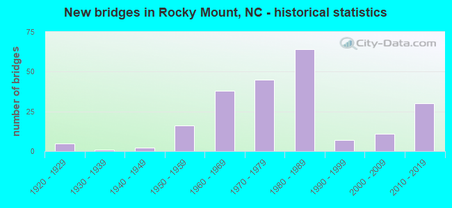
- New bridges - historical statistics
- 51920-1929
- 11930-1939
- 21940-1949
- 161950-1959
- 381960-1969
- 451970-1979
- 641980-1989
- 71990-1999
- 112000-2009
- 302010-2019
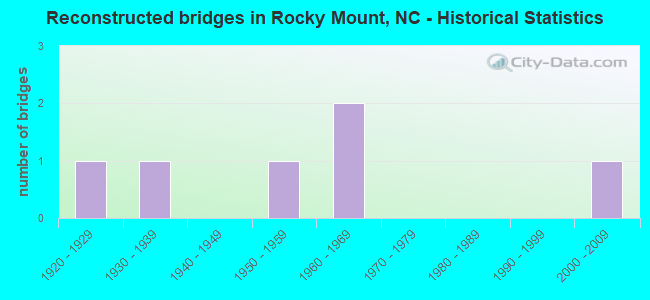
- Reconstructed bridges - Historical Statistics
- 11920-1929
- 11930-1939
- 01940-1949
- 11950-1959
- 21960-1969
- 01970-1979
- 01980-1989
- 01990-1999
- 12000-2009
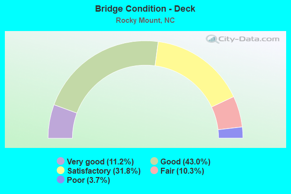
- Bridge Condition - Deck
- 11.2%Very good
- 43.0%Good
- 31.8%Satisfactory
- 10.3%Fair
- 3.7%Poor
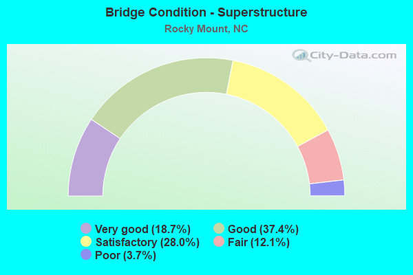
- Bridge Condition - Superstructure
- 18.7%Very good
- 37.4%Good
- 28.0%Satisfactory
- 12.1%Fair
- 3.7%Poor
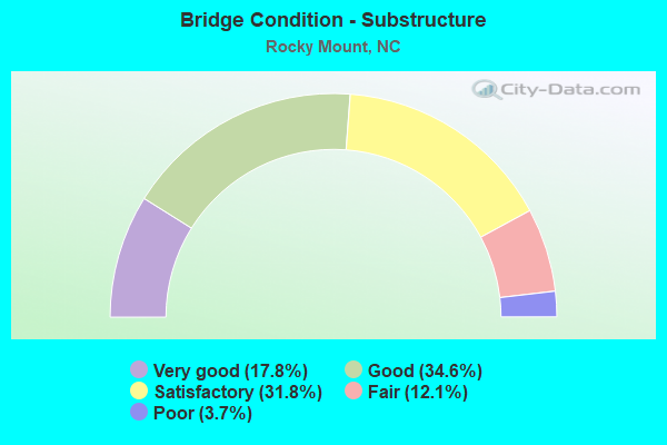
- Bridge Condition - Substructure
- 17.8%Very good
- 34.6%Good
- 31.8%Satisfactory
- 12.1%Fair
- 3.7%Poor
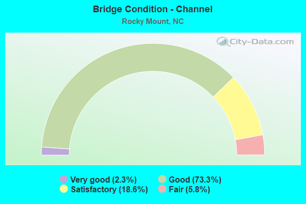
- Bridge Condition - Channel
- 2.3%Very good
- 73.3%Good
- 18.6%Satisfactory
- 5.8%Fair
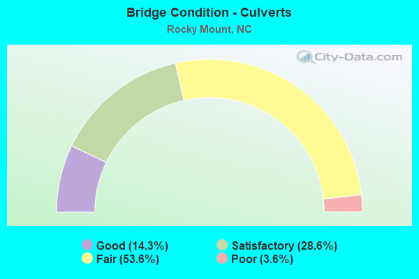
- Bridge Condition - Culverts
- 14.3%Good
- 28.6%Satisfactory
- 53.6%Fair
- 3.6%Poor
Find on map >> Show street view
Structure Number: 1270317, Location: 0.4MI.N. OF JCT.SR1717 (Lat: 35.926714, Lng: -77.846042), Route carried "on" structure: State highway 1613, Year Built: 1991, Status: Open, Structure Length: 1.70m (5.58ft), Average Daily Traffic: 1,200 (year 2017), Truck Traffic: 6%, Average Future Daily Traffic: 2,400 (year 2040), Design Load: HS 20+Mod, Features Intersected: GRAPE BRANCH
Minimum Vertical Clearance: 30+ m (98+ ft), Kilometerpoint: 0.000, Lanes on structure: 3, Owner: State Highway Agency, Approaching Roadway Width: 12.4m (40.7ft), Skew: 1 degrees, Material/Design: Concrete continuous, Design/Construction: Culvert, Number Of Spans In Main Unit: 4, Length of Maximum Span: 3.9m (12.8ft)
Condition: Channel: Satisfactory, Culverts: Fair, Operating Rating: 41.7 metric tons, Method Used To Determine Operating Rating: Field evaluation and documented engineering judgment, Inventory Rating: 32.6 metric tons, Method Used To Determine Inventory Rating: Field evaluation and documented engineering judgment, Structural Evaluation: Somewhat better than minimum adequacy, Waterway Adequacy: Better than present minimum criteria, Approach Roadway Alignment: Equal to present desirable criteria, Designated Inspection Frequency: Every 24 months, Inspection Date: June 2020
Find on map >> Show street view
Structure Number: 1270322, Location: 1 MI. N. OFJCT.US301 BUS. (Lat: 35.959706, Lng: -77.804744), Route carried "on" structure: State highway 43, Year Built: 1997, Status: Open, Structure Length: 19.17m (62.89ft), Average Daily Traffic: 6,700 (year 2015), Truck Traffic: 6%, Average Future Daily Traffic: 13,400 (year 2040), Design Load: HS 20+Mod, Features Intersected: TAR RIVER, Facility Carried by Structure: NC48
Minimum Vertical Clearance: 30+ m (98+ ft), Kilometerpoint: 0.000, Lanes on structure: 2, Owner: State Highway Agency, Approaching Roadway Width: 8.5m (27.9ft), Skew: 10 degrees, Material/Design: Prestressed concrete, Design/Construction: Slab, Number Of Spans In Main Unit: 12, Length of Maximum Span: 15.5m (50.9ft), Curb or Sidewalk Widths: Left: 1.5m (4.9ft), Right: 0.0m, Curb-To-Curb Width: 8.5m (27.9ft), Out-to-Out Width: 10.9m (35.8ft)
Condition: Deck: Good, Superstructure: Good, Substructure: Good, Channel: Good, Operating Rating: 89.8 metric tons, Method Used To Determine Operating Rating: Load Factor (LF), Inventory Rating: 56.2 metric tons, Method Used To Determine Inventory Rating: Load Factor (LF), Structural Evaluation: Better than present minimum criteria, Deck Geometry: High priority of corrective action, Waterway Adequacy: Better than present minimum criteria, Approach Roadway Alignment: Equal to present desirable criteria, Designated Inspection Frequency: Every 24 months, Inspection Date: September 2020, Deck Structure Type: Concrete Precast Panels, Wearing Surface/Protective System: Wearing Surface: Bituminous, Deck Protection: Epoxy Coated Reinforcing
Find on map >> Show street view
Structure Number: 1270331, Location: 0.2 MI.E. NC301 (Lat: 36.041492, Lng: -77.752758), Route carried "on" structure: State highway 1524, Year Built: 2005, Status: Open, Structure Length: 27.70m (90.88ft), Average Daily Traffic: 900 (year 2019), Truck Traffic: 7%, Average Future Daily Traffic: 1,800 (year 2040), Design Load: HS 20+Mod, Features Intersected: CSX R/R & TRIB.BEECH BR.
Minimum Vertical Clearance: 30+ m (98+ ft), Kilometerpoint: 0.000, Lanes on structure: 2, Owner: State Highway Agency, Approaching Roadway Width: 10.3m (33.8ft), Skew: 9 degrees, Material/Design: Steel continuous, Design/Construction: Stringer/Multi-beam, Number Of Spans In Main Unit: 7, Length of Maximum Span: 46.6m (152.9ft), Curb-To-Curb Width: 9.7m (31.8ft), Out-to-Out Width: 10.6m (34.8ft)
Condition: Deck: Very good, Superstructure: Very good, Substructure: Very good, Channel: Good, Operating Rating: 89.8 metric tons, Method Used To Determine Operating Rating: Load Factor (LF), Inventory Rating: 71.6 metric tons, Method Used To Determine Inventory Rating: Load Factor (LF), Structural Evaluation: Equal to present desirable criteria, Deck Geometry: Equal to present minimum criteria, Underclear: Superior to present desirable criteria, Waterway Adequacy: Superior to present desirable criteria, Approach Roadway Alignment: Equal to present desirable criteria, Designated Inspection Frequency: Every 24 months, Inspection Date: November 2020, Deck Structure Type: Concrete Cast-file-Place, Wearing Surface/Protective System: Wearing Surface: Monolithic Concrete, Deck Protection: Epoxy Coated Reinforcing
Find on map >> Show street view
Structure Number: 1270334, Location: 0.6 MI. E. JCT. SR1616 (Lat: 35.967667, Lng: -77.808667), Route carried "on" structure: State highway 1604, Year Built: 2013, Status: Open, Structure Length: 6.61m (21.69ft), Average Daily Traffic: 4,400 (year 2019), Truck Traffic: 6%, Average Future Daily Traffic: 8,800 (year 2040), Design Load: HL 93, Features Intersected: US301
Minimum Vertical Clearance: 30+ m (98+ ft), Kilometerpoint: 0.000, Lanes on structure: 2, Lanes under structure: 4, Owner: State Highway Agency, Approaching Roadway Width: 8.2m (26.9ft), Skew: 11 degrees, Material/Design: Steel continuous, Design/Construction: Stringer/Multi-beam, Number Of Spans In Main Unit: 2, Length of Maximum Span: 32.6m (107.0ft), Curb or Sidewalk Widths: Left: 1.6m (5.2ft), Right: 0.0m, Curb-To-Curb Width: 9.1m (29.9ft), Out-to-Out Width: 11.7m (38.4ft)
Condition: Deck: Good, Superstructure: Very good, Substructure: Good, Operating Rating: 89.8 metric tons, Method Used To Determine Operating Rating: Load and Resistance Factor (LRFR), Inventory Rating: 68.9 metric tons, Method Used To Determine Inventory Rating: Load and Resistance Factor (LRFR), Structural Evaluation: Better than present minimum criteria, Deck Geometry: Meets minimum limits, Underclear: Meets minimum limits, Approach Roadway Alignment: Equal to present desirable criteria, Designated Inspection Frequency: Every 24 months, Inspection Date: August 2021, Deck Structure Type: Concrete Cast-file-Place, Wearing Surface/Protective System: Wearing Surface: Monolithic Concrete, Deck Protection: Epoxy Coated Reinforcing
Find on map >> Show street view
Structure Number: 1270335, Location: 0.5 MI.E. OF JCT.NC43 (Lat: 36.002661, Lng: -77.821511), Route carried "on" structure: State highway 1613, Year Built: 2011, Status: Open, Structure Length: 3.04m (9.97ft), Average Daily Traffic: 3,750 (year 2013), Truck Traffic: 7%, Average Future Daily Traffic: 7,500 (year 2040), Design Load: HL 93, Features Intersected: HORNBEAM BRANCH
Minimum Vertical Clearance: 30+ m (98+ ft), Kilometerpoint: 1.981, Lanes on structure: 2, Owner: State Highway Agency, Approaching Roadway Width: 10.9m (35.8ft), Skew: 10 degrees, Material/Design: Prestressed concrete, Design/Construction: Stringer/Multi-beam, Number Of Spans In Main Unit: 1, Length of Maximum Span: 29.5m (96.8ft), Curb-To-Curb Width: 10.9m (35.8ft), Out-to-Out Width: 11.9m (39.0ft)
Condition: Deck: Good, Superstructure: Good, Substructure: Very good, Channel: Good, Operating Rating: 75.2 metric tons, Method Used To Determine Operating Rating: Load and Resistance Factor (LRFR), Inventory Rating: 45.3 metric tons, Method Used To Determine Inventory Rating: Load and Resistance Factor (LRFR), Structural Evaluation: Better than present minimum criteria, Deck Geometry: High priority of corrective action, Waterway Adequacy: Better than present minimum criteria, Approach Roadway Alignment: Equal to present desirable criteria, Designated Inspection Frequency: Every 24 months, Inspection Date: August 2020, Deck Structure Type: Concrete Cast-file-Place, Wearing Surface/Protective System: Wearing Surface: Monolithic Concrete, Membrane: Built-up, Deck Protection: Epoxy Coated Reinforcing
Find on map >> Show street view
Structure Number: 1270336, Location: 0.5MI.E. OF JCT.NC43 (Lat: 36.002503, Lng: -77.821358), Route carried "on" structure: State highway 1613, Year Built: 2011, Status: Open, Structure Length: 3.04m (9.97ft), Average Daily Traffic: 3,750 (year 2013), Truck Traffic: 6%, Average Future Daily Traffic: 7,500 (year 2040), Design Load: HL 93, Features Intersected: HORNBEAM BRANCH
Minimum Vertical Clearance: 30+ m (98+ ft), Kilometerpoint: 1.981, Lanes on structure: 2, Owner: State Highway Agency, Approaching Roadway Width: 10.9m (35.8ft), Skew: 10 degrees, Material/Design: Prestressed concrete, Design/Construction: Stringer/Multi-beam, Number Of Spans In Main Unit: 1, Length of Maximum Span: 29.5m (96.8ft), Curb-To-Curb Width: 10.9m (35.8ft), Out-to-Out Width: 11.9m (39.0ft)
Condition: Deck: Good, Superstructure: Very good, Substructure: Good, Channel: Good, Operating Rating: 75.2 metric tons, Method Used To Determine Operating Rating: Load and Resistance Factor (LRFR), Inventory Rating: 45.3 metric tons, Method Used To Determine Inventory Rating: Load and Resistance Factor (LRFR), Structural Evaluation: Better than present minimum criteria, Deck Geometry: High priority of corrective action, Waterway Adequacy: Better than present minimum criteria, Approach Roadway Alignment: Equal to present desirable criteria, Designated Inspection Frequency: Every 24 months, Inspection Date: August 2020, Deck Structure Type: Concrete Cast-file-Place, Wearing Surface/Protective System: Wearing Surface: Monolithic Concrete, Membrane: Built-up, Deck Protection: Epoxy Coated Reinforcing
Find on map >> Show street view
Structure Number: 1270337, Location: 0.6 MI. E. OF JCT. NC48 (Lat: 36.006550, Lng: -77.798919), Route carried "on" structure: State highway 1613, Year Built: 2011, Status: Open, Structure Length: 10.14m (33.27ft), Average Daily Traffic: 3,400 (year 2013), Truck Traffic: 6%, Average Future Daily Traffic: 6,800 (year 2025), Design Load: HL 93, Features Intersected: COMPASS CREEK
Minimum Vertical Clearance: 30+ m (98+ ft), Kilometerpoint: 2.286, Lanes on structure: 2, Owner: State Highway Agency, Approaching Roadway Width: 9.4m (30.8ft), Skew: 10 degrees, Material/Design: Prestressed concrete, Design/Construction: Stringer/Multi-beam, Number Of Spans In Main Unit: 3, Length of Maximum Span: 33.2m (108.9ft), Curb-To-Curb Width: 10.7m (35.1ft), Out-to-Out Width: 11.9m (39.0ft)
Condition: Deck: Good, Superstructure: Good, Substructure: Good, Channel: Good, Operating Rating: 83.4 metric tons, Method Used To Determine Operating Rating: Load and Resistance Factor (LRFR), Inventory Rating: 44.4 metric tons, Method Used To Determine Inventory Rating: Load and Resistance Factor (LRFR), Structural Evaluation: Better than present minimum criteria, Deck Geometry: Somewhat better than minimum adequacy, Waterway Adequacy: Better than present minimum criteria, Approach Roadway Alignment: Equal to present desirable criteria, Designated Inspection Frequency: Every 24 months, Inspection Date: August 2020, Deck Structure Type: Concrete Cast-file-Place, Wearing Surface/Protective System: Wearing Surface: Monolithic Concrete, Deck Protection: Epoxy Coated Reinforcing
Find on map >> Show street view
Structure Number: 1270338, Location: 0.6 MI.E. OF NC48 (Lat: 36.006378, Lng: -77.798811), Route carried "on" structure: State highway 1613, Year Built: 2011, Status: Open, Structure Length: 10.14m (33.27ft), Average Daily Traffic: 3,400 (year 2013), Truck Traffic: 6%, Average Future Daily Traffic: 6,800 (year 2025), Design Load: HL 93, Features Intersected: COMPASS CREEK
Minimum Vertical Clearance: 30+ m (98+ ft), Kilometerpoint: 2.286, Lanes on structure: 2, Owner: State Highway Agency, Approaching Roadway Width: 9.4m (30.8ft), Skew: 10 degrees, Material/Design: Prestressed concrete, Design/Construction: Stringer/Multi-beam, Number Of Spans In Main Unit: 3, Length of Maximum Span: 33.2m (108.9ft), Curb-To-Curb Width: 10.7m (35.1ft), Out-to-Out Width: 11.9m (39.0ft)
Condition: Deck: Good, Superstructure: Good, Substructure: Good, Channel: Good, Operating Rating: 83.4 metric tons, Method Used To Determine Operating Rating: Load and Resistance Factor (LRFR), Inventory Rating: 44.4 metric tons, Method Used To Determine Inventory Rating: Load and Resistance Factor (LRFR), Structural Evaluation: Better than present minimum criteria, Deck Geometry: Somewhat better than minimum adequacy, Waterway Adequacy: Better than present minimum criteria, Approach Roadway Alignment: Equal to present desirable criteria, Designated Inspection Frequency: Every 24 months, Inspection Date: August 2020, Deck Structure Type: Concrete Cast-file-Place, Wearing Surface/Protective System: Wearing Surface: Monolithic Concrete, Deck Protection: Epoxy Coated Reinforcing
Find on map >> Show street view
Structure Number: 1270345, Location: 0.1 MI.S. GLOUCESTER RD. (Lat: 35.948250, Lng: -77.861358), Route carried "on" structure: City street , Year Built: 2014, Status: Open, Structure Length: 0.67m (2.20ft), Average Daily Traffic: 100 (year 2017), Truck Traffic: 6%, Average Future Daily Traffic: 200 (year 2040), Design Load: HS 20, Features Intersected: BR. OF MAPLE CREEK, Facility Carried by Structure: WOODSTOCK RD.
Minimum Vertical Clearance: 30+ m (98+ ft), Kilometerpoint: 0.000, Lanes on structure: 2, Owner: City or Municipal Highway Agency, Approaching Roadway Width: 9.1m (29.9ft), Material/Design: Prestressed concrete, Design/Construction: Culvert, Number Of Spans In Main Unit: 2, Length of Maximum Span: 3.0m (9.8ft)
Condition: Channel: Good, Culverts: Good, Operating Rating: 41.7 metric tons, Method Used To Determine Operating Rating: Field evaluation and documented engineering judgment, Inventory Rating: 32.6 metric tons, Method Used To Determine Inventory Rating: Field evaluation and documented engineering judgment, Structural Evaluation: Better than present minimum criteria, Waterway Adequacy: Better than present minimum criteria, Approach Roadway Alignment: Equal to present desirable criteria, Designated Inspection Frequency: Every 24 months, Inspection Date: April 2020
Find on map >> Show street view
Structure Number: 1470504, Location: 1 MI. N. JCT. US13,US26 (Lat: 35.971697, Lng: -77.773100), Route carried "on" structure: Bypass US 264, Year Built: 2018, Status: Open, Structure Length: 3.65m (11.98ft), Average Daily Traffic: 9,000 (year 2018), Truck Traffic: 14%, Average Future Daily Traffic: 18,000 (year 2040), Design Load: HL 93, Features Intersected: SR1127
Minimum Vertical Clearance: 30+ m (98+ ft), Kilometerpoint: 36.881, Lanes on structure: 2, Lanes under structure: 2, Base Highway Network: Yes (Inventory Route: 2, Subroute: 64), Owner: State Highway Agency, Approaching Roadway Width: 12.8m (42.0ft), Skew: 12 degrees, Material/Design: Prestressed concrete, Design/Construction: Stringer/Multi-beam, Number Of Spans In Main Unit: 1, Length of Maximum Span: 35.6m (116.8ft), Curb-To-Curb Width: 12.6m (41.3ft), Out-to-Out Width: 13.7m (44.9ft)
Condition: Deck: Very good, Superstructure: Very good, Substructure: Very good, Operating Rating: 64.4 metric tons, Method Used To Determine Operating Rating: Load and Resistance Factor (LRFR), Inventory Rating: 47.1 metric tons, Method Used To Determine Inventory Rating: Load and Resistance Factor (LRFR), Structural Evaluation: Equal to present desirable criteria, Deck Geometry: Better than present minimum criteria, Underclear: Somewhat better than minimum adequacy, Approach Roadway Alignment: Equal to present desirable criteria, Designated Inspection Frequency: Every 24 months, Inspection Date: November 2020, Deck Structure Type: Concrete Cast-file-Place, Wearing Surface/Protective System: Wearing Surface: Monolithic Concrete, Deck Protection: Epoxy Coated Reinforcing
Find on map >> Show street view
Structure Number: 650133, Location: 0.3 MI.E. OF US301 BUS. (Lat: 35.958153, Lng: -77.785867), Route carried "under" structure: State highway 97, Year Built: 1981, Structure Length: 0. m, Average Daily Traffic: 1,700 (year 2017), Truck Traffic: 6%, Features Intersected: US64E
Minimum Vertical Clearance: 5.79m (19.00ft), Kilometerpoint: 0.000, Lanes on structure: 3, Lanes under structure: 2, Material/Design: Steel, Design/Construction: Stringer/Multi-beam, Length of Maximum Span: 33.2m (108.9ft)
Find on map >> Show street view
Structure Number: 650133, Location: 0.3 MI.E. OF US301 BUS. (Lat: 35.958153, Lng: -77.785867), Route carried "under" structure: State highway 97, Year Built: 1981, Structure Length: 0. m, Average Daily Traffic: 1,700 (year 2017), Truck Traffic: 6%, Features Intersected: US64E
Minimum Vertical Clearance: 5.75m (18.86ft), Kilometerpoint: 0.000, Lanes on structure: 3, Lanes under structure: 2, Material/Design: Steel, Design/Construction: Stringer/Multi-beam, Length of Maximum Span: 33.2m (108.9ft)
Find on map >> Show street view
Structure Number: 650134, Location: 0.3 MI.E. OF US301 BUS. (Lat: 35.958339, Lng: -77.785778), Route carried "under" structure: State highway 97, Year Built: 1981, Structure Length: 0. m, Average Daily Traffic: 1,750 (year 2015), Truck Traffic: 8%, Features Intersected: US64W, NC43
Minimum Vertical Clearance: 5.00m (16.40ft), Kilometerpoint: 0.000, Lanes on structure: 3, Lanes under structure: 2, Material/Design: Steel, Design/Construction: Stringer/Multi-beam, Length of Maximum Span: 33.2m (108.9ft)
Find on map >> Show street view
Structure Number: 650134, Location: 0.3 MI.E. OF US301 BUS. (Lat: 35.958339, Lng: -77.785778), Route carried "under" structure: State highway 97, Year Built: 1981, Structure Length: 0. m, Average Daily Traffic: 1,750 (year 2015), Truck Traffic: 8%, Features Intersected: US64W, NC43
Minimum Vertical Clearance: 5.10m (16.73ft), Kilometerpoint: 0.000, Lanes on structure: 3, Lanes under structure: 2, Material/Design: Steel, Design/Construction: Stringer/Multi-beam, Length of Maximum Span: 33.2m (108.9ft)
Find on map >> Show street view
Structure Number: 650138, Location: 0.7 MI. E. JCT. N.C.97 (Lat: 35.958950, Lng: -77.772744), Route carried "under" structure: State highway 1243, Year Built: 1981, Structure Length: 0. m, Average Daily Traffic: 2,600 (year 2015), Truck Traffic: 6%, Features Intersected: US64 E
Minimum Vertical Clearance: 4.95m (16.24ft), Kilometerpoint: 0.000, Lanes on structure: 2, Lanes under structure: 2, Material/Design: Steel, Design/Construction: Stringer/Multi-beam, Length of Maximum Span: 33.5m (109.9ft)
Find on map >> Show street view
Structure Number: 650139, Location: 0.7 MI. E. JCT. N.C.97 (Lat: 35.959164, Lng: -77.772547), Route carried "under" structure: State highway 1243, Year Built: 1981, Structure Length: 0. m, Average Daily Traffic: 2,600 (year 2018), Truck Traffic: 6%, Features Intersected: US64W BYP; NC43
Minimum Vertical Clearance: 5.76m (18.90ft), Kilometerpoint: 0.000, Lanes on structure: 2, Lanes under structure: 2, Material/Design: Steel, Design/Construction: Stringer/Multi-beam, Length of Maximum Span: 32.6m (107.0ft)
Find on map >> Show street view
Structure Number: 65014, Location: 0.3 MI.E. OF SR1232 (Lat: 35.945692, Lng: -77.759675), Route carried "under" structure: US 64, Year Built: 1981, Structure Length: 0. m, Average Daily Traffic: 16,000 (year 2018), Truck Traffic: 12%, Features Intersected: US64 BUS.
Minimum Vertical Clearance: 5.20m (17.06ft), Kilometerpoint: 143.867, Lanes on structure: 5, Lanes under structure: 2, Material/Design: Steel, Design/Construction: Stringer/Multi-beam, Length of Maximum Span: 36.5m (119.8ft)
Find on map >> Show street view
Structure Number: 65014, Location: 0.3 MI.E. OF SR1232 (Lat: 35.945692, Lng: -77.759675), Route carried "under" structure: US 64, Year Built: 1981, Structure Length: 0. m, Average Daily Traffic: 16,000 (year 2018), Truck Traffic: 12%, Features Intersected: US64 BUS.
Minimum Vertical Clearance: 5.23m (17.16ft), Kilometerpoint: 143.867, Lanes on structure: 5, Lanes under structure: 2, Material/Design: Steel, Design/Construction: Stringer/Multi-beam, Length of Maximum Span: 36.5m (119.8ft)
Find on map >> Show street view
Structure Number: 650145, Location: 0.4 MI.N.JCT.SR1232 (Lat: 35.935431, Lng: -77.730203), Route carried "under" structure: Bypass US 64, Year Built: 1985, Structure Length: 0. m, Average Daily Traffic: 10,500 (year 2015), Truck Traffic: 14%, Features Intersected: SR1233
Minimum Vertical Clearance: 4.85m (15.91ft), Kilometerpoint: 144.598, Lanes on structure: 2, Lanes under structure: 2, Material/Design: Prestressed concrete, Design/Construction: Stringer/Multi-beam, Length of Maximum Span: 27.1m (88.9ft)
Find on map >> Show street view
Structure Number: 650145, Location: 0.4 MI.N.JCT.SR1232 (Lat: 35.935431, Lng: -77.730203), Route carried "under" structure: Bypass US 64, Year Built: 1985, Structure Length: 0. m, Average Daily Traffic: 10,500 (year 2015), Truck Traffic: 14%, Features Intersected: SR1233
Minimum Vertical Clearance: 5.18m (16.99ft), Kilometerpoint: 144.598, Lanes on structure: 2, Lanes under structure: 2, Material/Design: Prestressed concrete, Design/Construction: Stringer/Multi-beam, Length of Maximum Span: 27.1m (88.9ft)
Find on map >> Show street view
Structure Number: 650146, Location: 0.2 MI.N.JCT.SR1232 (Lat: 35.932619, Lng: -77.709706), Route carried "under" structure: Bypass US 64, Year Built: 1986, Structure Length: 0. m, Average Daily Traffic: 10,500 (year 2015), Truck Traffic: 14%, Features Intersected: SR1226
Minimum Vertical Clearance: 4.97m (16.31ft), Kilometerpoint: 145.147, Lanes on structure: 2, Lanes under structure: 2, Material/Design: Prestressed concrete, Design/Construction: Stringer/Multi-beam, Length of Maximum Span: 27.1m (88.9ft)
Find on map >> Show street view
Structure Number: 650146, Location: 0.2 MI.N.JCT.SR1232 (Lat: 35.932619, Lng: -77.709706), Route carried "under" structure: Bypass US 64, Year Built: 1986, Structure Length: 0. m, Average Daily Traffic: 10,500 (year 2015), Truck Traffic: 14%, Features Intersected: SR1226
Minimum Vertical Clearance: 4.90m (16.08ft), Kilometerpoint: 145.147, Lanes on structure: 2, Lanes under structure: 2, Material/Design: Prestressed concrete, Design/Construction: Stringer/Multi-beam, Length of Maximum Span: 27.1m (88.9ft)
Find on map >> Show street view
Structure Number: 650343, Location: 0.3 MI.N.JCT SR1232 (Lat: 35.939872, Lng: -77.755333), Route carried "under" structure: Bypass US 64, Year Built: 2001, Structure Length: 0. m, Average Daily Traffic: 11,500 (year 2019), Truck Traffic: 12%, Features Intersected: NC43 BYPAS
Minimum Vertical Clearance: 5.41m (17.75ft), Kilometerpoint: 143.958, Lanes on structure: 2, Lanes under structure: 2, Material/Design: Prestressed concrete, Design/Construction: Stringer/Multi-beam, Length of Maximum Span: 21.0m (68.9ft)
Find on map >> Show street view
Structure Number: 650343, Location: 0.3 MI.N.JCT SR1232 (Lat: 35.939872, Lng: -77.755333), Route carried "under" structure: Bypass US 64, Year Built: 2001, Structure Length: 0. m, Average Daily Traffic: 11,500 (year 2019), Truck Traffic: 12%, Features Intersected: NC43 BYPAS
Minimum Vertical Clearance: 5.28m (17.32ft), Kilometerpoint: 143.958, Lanes on structure: 2, Lanes under structure: 2, Material/Design: Prestressed concrete, Design/Construction: Stringer/Multi-beam, Length of Maximum Span: 21.0m (68.9ft)
Find on map >> Show street view
Structure Number: 1270075, Location: 0.7 MI. N. SR1729 (Lat: 35.912861, Lng: -77.830614), Route carried "under" structure: State highway 97, Year Built: 1954, Structure Length: 0. m, Average Daily Traffic: 7,400 (year 2017), Truck Traffic: 12%, Features Intersected: US301BYP N
Minimum Vertical Clearance: 4.41m (14.47ft), Kilometerpoint: 0.000, Lanes on structure: 2, Lanes under structure: 2, Material/Design: Steel, Design/Construction: Stringer/Multi-beam, Length of Maximum Span: 14.9m (48.9ft)
Find on map >> Show street view
Structure Number: 1270078, Location: 0.7 MI.N. OF SR1729 (Lat: 35.912672, Lng: -77.830817), Route carried "under" structure: State highway 97, Year Built: 1963, Structure Length: 0. m, Average Daily Traffic: 7,300 (year 2017), Truck Traffic: 6%, Features Intersected: US301BYP S
Minimum Vertical Clearance: 4.82m (15.81ft), Kilometerpoint: 0.000, Lanes on structure: 3, Lanes under structure: 2, Material/Design: Steel, Design/Construction: Stringer/Multi-beam, Length of Maximum Span: 14.9m (48.9ft)
Find on map >> Show street view
Structure Number: 1270094, Location: 0.1 MI.E.JCT. US301B SBL (Lat: 35.936039, Lng: -77.799744), Route carried "under" structure: Business US 301, Year Built: 1957, Structure Length: 0. m, Average Daily Traffic: 2,500 (year 2013), Truck Traffic: 12%, Features Intersected: NC97
Minimum Vertical Clearance: 4.80m (15.75ft), Kilometerpoint: 0.000, Lanes on structure: 2, Lanes under structure: 3, Material/Design: Steel, Design/Construction: Stringer/Multi-beam, Length of Maximum Span: 21.6m (70.9ft)
Find on map >> Show street view
Structure Number: 1270094, Location: 0.1 MI.E.JCT. US301B SBL (Lat: 35.936039, Lng: -77.799744), Route carried "under" structure: Business US 301, Year Built: 1957, Structure Length: 0. m, Average Daily Traffic: 100 (year 2013), Truck Traffic: 7%, Features Intersected: NC97, Facility Carried by Structure: WASHINGTON ST.
Minimum Vertical Clearance: 4.67m (15.32ft), Kilometerpoint: 0.000, Lanes on structure: 2, Lanes under structure: 2, Material/Design: Steel, Design/Construction: Stringer/Multi-beam, Length of Maximum Span: 21.6m (70.9ft)
Find on map >> Show street view
Structure Number: 1270098, Location: 0.7 MI.N. OF SR1510 (Lat: 36.083511, Lng: -77.808881), Route carried "under" structure: Interstate 95, Year Built: 1966, Structure Length: 0. m, Average Daily Traffic: 23,000 (year 2019), Truck Traffic: 23%, Features Intersected: NC4,NC48
Minimum Vertical Clearance: 5.15m (16.90ft), Kilometerpoint: 44.684, Lanes on structure: 2, Lanes under structure: 2, Material/Design: Steel, Design/Construction: Stringer/Multi-beam, Length of Maximum Span: 24.6m (80.7ft)
Find on map >> Show street view
Structure Number: 1270098, Location: 0.7 MI.N. OF SR1510 (Lat: 36.083511, Lng: -77.808881), Route carried "under" structure: Interstate 95, Year Built: 1966, Structure Length: 0. m, Average Daily Traffic: 23,000 (year 2019), Truck Traffic: 23%, Features Intersected: NC4,NC48
Minimum Vertical Clearance: 5.00m (16.40ft), Kilometerpoint: 44.684, Lanes on structure: 2, Lanes under structure: 2, Material/Design: Steel, Design/Construction: Stringer/Multi-beam, Length of Maximum Span: 24.6m (80.7ft)
Find on map >> Show street view
Structure Number: 1270101, Location: 0.2 MI.N. JCT.SR1598 (Lat: 35.973525, Lng: -77.802269), Route carried "under" structure: Bypass US 301, Year Built: 1988, Structure Length: 0. m, Average Daily Traffic: 11,500 (year 2017), Truck Traffic: 12%, Features Intersected: NC43, NC48
Minimum Vertical Clearance: 4.74m (15.55ft), Kilometerpoint: 0.000, Lanes on structure: 5, Lanes under structure: 3, Material/Design: Concrete, Design/Construction: Slab, Length of Maximum Span: 31.0m (101.7ft)
Find on map >> Show street view
Structure Number: 1270101, Location: 0.2 MI.N. JCT.SR1598 (Lat: 35.973525, Lng: -77.802269), Route carried "under" structure: Bypass US 301, Year Built: 1988, Structure Length: 0. m, Average Daily Traffic: 11,500 (year 2017), Truck Traffic: 12%, Features Intersected: NC43, NC48
Minimum Vertical Clearance: 4.90m (16.08ft), Kilometerpoint: 0.000, Lanes on structure: 5, Lanes under structure: 3, Material/Design: Concrete, Design/Construction: Slab, Length of Maximum Span: 31.0m (101.7ft)
Find on map >> Show street view
Structure Number: 1270154, Location: 0.7MI N OF SR1770 (Lat: 35.981044, Lng: -77.897519), Route carried "under" structure: US 64, Year Built: 1960, Structure Length: 0. m, Average Daily Traffic: 20,250 (year 2019), Truck Traffic: 12%, Features Intersected: SR1603
Minimum Vertical Clearance: 4.85m (15.91ft), Kilometerpoint: 141.124, Lanes on structure: 2, Lanes under structure: 1, Material/Design: Steel, Design/Construction: Stringer/Multi-beam, Length of Maximum Span: 17.6m (57.7ft)
Find on map >> Show street view
Structure Number: 1270154, Location: 0.7MI N OF SR1770 (Lat: 35.981044, Lng: -77.897519), Route carried "under" structure: US 64, Year Built: 1960, Structure Length: 0. m, Average Daily Traffic: 20,250 (year 2019), Truck Traffic: 12%, Features Intersected: SR1603
Minimum Vertical Clearance: 5.41m (17.75ft), Kilometerpoint: 141.124, Lanes on structure: 2, Lanes under structure: 1, Material/Design: Steel, Design/Construction: Stringer/Multi-beam, Length of Maximum Span: 17.6m (57.7ft)
Find on map >> Show street view
Structure Number: 1270158, Location: 0.1 MI. E. OF JCT. SR1717 (Lat: 35.934692, Lng: -77.829864), Route carried "under" structure: Bypass US 301, Year Built: 1991, Structure Length: 0. m, Average Daily Traffic: 10,250 (year 2019), Truck Traffic: 12%, Features Intersected: SR1714
Minimum Vertical Clearance: 5.08m (16.67ft), Kilometerpoint: 0.000, Lanes on structure: 2, Lanes under structure: 2, Material/Design: Steel, Design/Construction: Stringer/Multi-beam, Length of Maximum Span: 28.3m (92.8ft)
Find on map >> Show street view
Structure Number: 1270158, Location: 0.1 MI. E. OF JCT. SR1717 (Lat: 35.934692, Lng: -77.829864), Route carried "under" structure: Bypass US 301, Year Built: 1991, Structure Length: 0. m, Average Daily Traffic: 10,250 (year 2019), Truck Traffic: 12%, Features Intersected: SR1714
Minimum Vertical Clearance: 4.99m (16.37ft), Kilometerpoint: 0.000, Lanes on structure: 2, Lanes under structure: 2, Material/Design: Steel, Design/Construction: Stringer/Multi-beam, Length of Maximum Span: 28.3m (92.8ft)
Find on map >> Show street view
Structure Number: 1270162, Location: 1.2MI.E.OF SR1603 (Lat: 35.981592, Lng: -77.876789), Route carried "under" structure: Ramp Interstate 95, Year Built: 1977, Structure Length: 0. m, Average Daily Traffic: 12,375 (year 2019), Truck Traffic: 16%, Features Intersected: US64 E
Minimum Vertical Clearance: 5.10m (16.73ft), Kilometerpoint: 42.062, Lanes on structure: 3, Lanes under structure: 2, Material/Design: Steel continuous, Design/Construction: Stringer/Multi-beam, Length of Maximum Span: 29.8m (97.8ft)
Find on map >> Show street view
Structure Number: 1270162, Location: 1.2MI.E.OF SR1603 (Lat: 35.981592, Lng: -77.876789), Route carried "under" structure: Interstate 95, Year Built: 1977, Structure Length: 0. m, Average Daily Traffic: 24,750 (year 2018), Truck Traffic: 16%, Features Intersected: US64 E
Minimum Vertical Clearance: 5.25m (17.22ft), Kilometerpoint: 42.062, Lanes on structure: 3, Lanes under structure: 2, Material/Design: Steel continuous, Design/Construction: Stringer/Multi-beam, Length of Maximum Span: 29.8m (97.8ft)
Find on map >> Show street view
Structure Number: 1270162, Location: 1.2MI.E.OF SR1603 (Lat: 35.981592, Lng: -77.876789), Route carried "under" structure: Ramp Interstate 95, Year Built: 1977, Structure Length: 0. m, Average Daily Traffic: 12,375 (year 2019), Truck Traffic: 16%, Features Intersected: US64 E
Minimum Vertical Clearance: 5.10m (16.73ft), Kilometerpoint: 42.062, Lanes on structure: 3, Lanes under structure: 2, Material/Design: Steel continuous, Design/Construction: Stringer/Multi-beam, Length of Maximum Span: 29.8m (97.8ft)
Find on map >> Show street view
Structure Number: 1270162, Location: 1.2MI.E.OF SR1603 (Lat: 35.981592, Lng: -77.876789), Route carried "under" structure: Interstate 95, Year Built: 1977, Structure Length: 0. m, Average Daily Traffic: 24,750 (year 2019), Truck Traffic: 16%, Features Intersected: US64 E
Minimum Vertical Clearance: 5.15m (16.90ft), Kilometerpoint: 42.062, Lanes on structure: 3, Lanes under structure: 2, Material/Design: Steel continuous, Design/Construction: Stringer/Multi-beam, Length of Maximum Span: 29.8m (97.8ft)
Find on map >> Show street view
Structure Number: 1270163, Location: 1.2 MI. E. OF JCT. SR1603 (Lat: 35.982072, Lng: -77.876622), Route carried "under" structure: Bypass Interstate 95, Year Built: 1977, Structure Length: 0. m, Average Daily Traffic: 21,000 (year 2015), Truck Traffic: 23%, Features Intersected: US64 W
Minimum Vertical Clearance: 5.63m (18.47ft), Kilometerpoint: 42.062, Lanes on structure: 4, Lanes under structure: 2, Material/Design: Steel continuous, Design/Construction: Stringer/Multi-beam, Length of Maximum Span: 27.7m (90.9ft)
Find on map >> Show street view
Structure Number: 1270163, Location: 1.2 MI. E. OF JCT. SR1603 (Lat: 35.982072, Lng: -77.876622), Route carried "under" structure: Ramp Interstate 95, Year Built: 1977, Structure Length: 0. m, Average Daily Traffic: 14,000 (year 2015), Truck Traffic: 23%, Features Intersected: US64 W
Minimum Vertical Clearance: 5.58m (18.31ft), Kilometerpoint: 42.062, Lanes on structure: 4, Lanes under structure: 2, Material/Design: Steel continuous, Design/Construction: Stringer/Multi-beam, Length of Maximum Span: 27.7m (90.9ft)
Find on map >> Show street view
Structure Number: 1270163, Location: 1.2 MI. E. OF JCT. SR1603 (Lat: 35.982072, Lng: -77.876622), Route carried "under" structure: Bypass Interstate 95, Year Built: 1977, Structure Length: 0. m, Average Daily Traffic: 21,000 (year 2015), Truck Traffic: 23%, Features Intersected: US64 W
Minimum Vertical Clearance: 5.58m (18.31ft), Kilometerpoint: 42.062, Lanes on structure: 4, Lanes under structure: 2, Material/Design: Steel continuous, Design/Construction: Stringer/Multi-beam, Length of Maximum Span: 27.7m (90.9ft)
Find on map >> Show street view
Structure Number: 1270163, Location: 1.2 MI. E. OF JCT. SR1603 (Lat: 35.982072, Lng: -77.876622), Route carried "under" structure: Ramp Interstate 95, Year Built: 1977, Structure Length: 0. m, Average Daily Traffic: 14,000 (year 2015), Truck Traffic: 23%, Features Intersected: US64 W
Minimum Vertical Clearance: 5.43m (17.81ft), Kilometerpoint: 42.062, Lanes on structure: 4, Lanes under structure: 2, Material/Design: Steel continuous, Design/Construction: Stringer/Multi-beam, Length of Maximum Span: 27.7m (90.9ft)
Find on map >> Show street view
Structure Number: 1270169, Location: 0.3 MI. N. JCT. SR1828 (Lat: 35.981011, Lng: -77.868442), Route carried "under" structure: US 64, Year Built: 1972, Structure Length: 0. m, Average Daily Traffic: 22,750 (year 2019), Truck Traffic: 12%, Features Intersected: SR1544
Minimum Vertical Clearance: 4.95m (16.24ft), Kilometerpoint: 141.733, Lanes on structure: 2, Lanes under structure: 2, Material/Design: Steel continuous, Design/Construction: Stringer/Multi-beam, Length of Maximum Span: 37.1m (121.7ft)
Find on map >> Show street view
Structure Number: 1270169, Location: 0.3 MI. N. JCT. SR1828 (Lat: 35.981011, Lng: -77.868442), Route carried "under" structure: Ramp US , Year Built: 1972, Structure Length: 0. m, Average Daily Traffic: 11,375 (year 2019), Truck Traffic: 12%, Features Intersected: SR1544, Facility Carried by Structure: US64E,COLLECTOR
Minimum Vertical Clearance: 5.35m (17.55ft), Kilometerpoint: 141.733, Lanes on structure: 2, Lanes under structure: 1, Material/Design: Steel continuous, Design/Construction: Stringer/Multi-beam, Length of Maximum Span: 37.1m (121.7ft)
Find on map >> Show street view
Structure Number: 1270169, Location: 0.3 MI. N. JCT. SR1828 (Lat: 35.981011, Lng: -77.868442), Route carried "under" structure: Ramp US , Year Built: 1972, Structure Length: 0. m, Average Daily Traffic: 11,375 (year 2019), Truck Traffic: 12%, Features Intersected: SR1544, Facility Carried by Structure: US64W,COLLECTOR
Minimum Vertical Clearance: 5.08m (16.67ft), Kilometerpoint: 141.733, Lanes on structure: 2, Lanes under structure: 1, Material/Design: Steel continuous, Design/Construction: Stringer/Multi-beam, Length of Maximum Span: 37.1m (121.7ft)
Find on map >> Show street view
Structure Number: 1270169, Location: 0.3 MI. N. JCT. SR1828 (Lat: 35.981011, Lng: -77.868442), Route carried "under" structure: US 64, Year Built: 1972, Structure Length: 0. m, Average Daily Traffic: 22,750 (year 2019), Truck Traffic: 12%, Features Intersected: SR1544
Minimum Vertical Clearance: 5.05m (16.57ft), Kilometerpoint: 141.733, Lanes on structure: 2, Lanes under structure: 2, Material/Design: Steel continuous, Design/Construction: Stringer/Multi-beam, Length of Maximum Span: 37.1m (121.7ft)
Find on map >> Show street view
Structure Number: 1270177, Location: 0.1 MI.W. JCT. SR1707 (Lat: 35.931272, Lng: -77.902967), Route carried "under" structure: Interstate 95, Year Built: 1977, Structure Length: 0. m, Average Daily Traffic: 19,250 (year 2018), Truck Traffic: 23%, Features Intersected: SR1603
Minimum Vertical Clearance: 5.10m (16.73ft), Kilometerpoint: 40.996, Lanes on structure: 2, Lanes under structure: 2, Material/Design: Steel continuous, Design/Construction: Stringer/Multi-beam, Length of Maximum Span: 52.1m (170.9ft)
Find on map >> Show street view
Structure Number: 1270177, Location: 0.1 MI.W. JCT. SR1707 (Lat: 35.931272, Lng: -77.902967), Route carried "under" structure: Interstate 95, Year Built: 1977, Structure Length: 0. m, Average Daily Traffic: 19,250 (year 2018), Truck Traffic: 23%, Features Intersected: SR1603
Minimum Vertical Clearance: 5.30m (17.39ft), Kilometerpoint: 0.000, Lanes on structure: 2, Lanes under structure: 2, Material/Design: Steel continuous, Design/Construction: Stringer/Multi-beam, Length of Maximum Span: 52.1m (170.9ft)
Find on map >> Show street view
Structure Number: 1270179, Location: 0.2 MI.N JCT SR1634 (Lat: 35.975669, Lng: -77.847261), Route carried "under" structure: US 64, Year Built: 1974, Structure Length: 0. m, Average Daily Traffic: 22,750 (year 2019), Truck Traffic: 12%, Features Intersected: SR1613
Minimum Vertical Clearance: 5.07m (16.63ft), Kilometerpoint: 141.428, Lanes on structure: 7, Lanes under structure: 2, Material/Design: Steel, Design/Construction: Stringer/Multi-beam, Length of Maximum Span: 27.4m (89.9ft)
Find on map >> Show street view
Structure Number: 1270179, Location: 0.2 MI.N JCT SR1634 (Lat: 35.975669, Lng: -77.847261), Route carried "under" structure: US 64, Year Built: 1974, Structure Length: 0. m, Average Daily Traffic: 22,750 (year 2019), Truck Traffic: 12%, Features Intersected: SR1613
Minimum Vertical Clearance: 5.08m (16.67ft), Kilometerpoint: 141.428, Lanes on structure: 7, Lanes under structure: 3, Material/Design: Steel, Design/Construction: Stringer/Multi-beam, Length of Maximum Span: 27.4m (89.9ft)
Find on map >> Show street view
Structure Number: 1270181, Location: 0.6MI E. SR1616 (Lat: 35.968194, Lng: -77.814472), Route carried "under" structure: Bypass US 301, Year Built: 2013, Structure Length: 0. m, Average Daily Traffic: 18,000 (year 2017), Truck Traffic: 12%, Features Intersected: SR1604 EB
Minimum Vertical Clearance: 6.70m (21.98ft), Kilometerpoint: 0.000, Lanes on structure: 2, Lanes under structure: 3, Material/Design: Steel continuous, Design/Construction: Stringer/Multi-beam, Length of Maximum Span: 32.6m (107.0ft)
Find on map >> Show street view
Structure Number: 1270181, Location: 0.6MI E. SR1616 (Lat: 35.968194, Lng: -77.814472), Route carried "under" structure: Bypass US 301, Year Built: 2013, Structure Length: 0. m, Average Daily Traffic: 18,000 (year 2017), Truck Traffic: 12%, Features Intersected: SR1604 EB
Minimum Vertical Clearance: 6.20m (20.34ft), Kilometerpoint: 0.000, Lanes on structure: 2, Lanes under structure: 4, Material/Design: Steel continuous, Design/Construction: Stringer/Multi-beam, Length of Maximum Span: 32.6m (107.0ft)
Find on map >> Show street view
Structure Number: 1270183, Location: 0.9 MI E. JCT SR1603 (Lat: 35.945117, Lng: -77.892411), Route carried "under" structure: Interstate 95, Year Built: 1978, Structure Length: 0. m, Average Daily Traffic: 19,250 (year 2018), Truck Traffic: 23%, Features Intersected: SR1700
Minimum Vertical Clearance: 6.07m (19.91ft), Kilometerpoint: 41.453, Lanes on structure: 2, Lanes under structure: 2, Material/Design: Steel continuous, Design/Construction: Stringer/Multi-beam, Length of Maximum Span: 37.1m (121.7ft)
Find on map >> Show street view
Structure Number: 1270183, Location: 0.9 MI E. JCT SR1603 (Lat: 35.945117, Lng: -77.892411), Route carried "under" structure: Interstate 95, Year Built: 1978, Structure Length: 0. m, Average Daily Traffic: 19,250 (year 2018), Truck Traffic: 23%, Features Intersected: SR1700
Minimum Vertical Clearance: 5.08m (16.67ft), Kilometerpoint: 41.453, Lanes on structure: 2, Lanes under structure: 2, Material/Design: Steel continuous, Design/Construction: Stringer/Multi-beam, Length of Maximum Span: 37.1m (121.7ft)
Find on map >> Show street view
Structure Number: 1270185, Location: 0.7 MI.W.OF SR1616 (Lat: 35.970600, Lng: -77.834019), Route carried "under" structure: US 64, Year Built: 1981, Structure Length: 0. m, Average Daily Traffic: 18,000 (year 2019), Truck Traffic: 12%, Features Intersected: US64B EBL
Minimum Vertical Clearance: 5.13m (16.83ft), Kilometerpoint: 0.000, Lanes on structure: 1, Lanes under structure: 2, Material/Design: Steel, Design/Construction: Stringer/Multi-beam, Length of Maximum Span: 31.3m (102.7ft)
Find on map >> Show street view
Structure Number: 1270185, Location: 0.7 MI.W.OF SR1616 (Lat: 35.970600, Lng: -77.834019), Route carried "under" structure: US 64, Year Built: 1981, Structure Length: 0. m, Average Daily Traffic: 18,000 (year 2019), Truck Traffic: 12%, Features Intersected: US64B EBL
Minimum Vertical Clearance: 5.18m (16.99ft), Kilometerpoint: 0.000, Lanes on structure: 1, Lanes under structure: 2, Material/Design: Steel, Design/Construction: Stringer/Multi-beam, Length of Maximum Span: 31.3m (102.7ft)
Find on map >> Show street view
Structure Number: 1270188, Location: 0.7MI W OF SR1616 (Lat: 35.970606, Lng: -77.833728), Route carried "under" structure: US 64, Year Built: 1981, Structure Length: 0. m, Average Daily Traffic: 17,000 (year 2013), Truck Traffic: 12%, Features Intersected: US64B WBL
Minimum Vertical Clearance: 5.25m (17.22ft), Kilometerpoint: 0.000, Lanes on structure: 2, Lanes under structure: 2, Material/Design: Steel, Design/Construction: Stringer/Multi-beam, Length of Maximum Span: 30.7m (100.7ft)
Find on map >> Show street view
Structure Number: 1270188, Location: 0.7MI W OF SR1616 (Lat: 35.970606, Lng: -77.833728), Route carried "under" structure: US 64, Year Built: 1981, Structure Length: 0. m, Average Daily Traffic: 17,000 (year 2013), Truck Traffic: 12%, Features Intersected: US64B WBL
Minimum Vertical Clearance: 5.18m (16.99ft), Kilometerpoint: 0.000, Lanes on structure: 2, Lanes under structure: 2, Material/Design: Steel, Design/Construction: Stringer/Multi-beam, Length of Maximum Span: 30.7m (100.7ft)
Find on map >> Show street view
Structure Number: 1270196, Location: 0.2M. W. JCT. SR1836 (Lat: 35.957358, Lng: -77.823783), Route carried "under" structure: Bypass US 301, Year Built: 2018, Structure Length: 0. m, Average Daily Traffic: 9,750 (year 2019), Truck Traffic: 12%, Features Intersected: US64E
Minimum Vertical Clearance: 5.91m (19.39ft), Kilometerpoint: 0.000, Lanes on structure: 3, Lanes under structure: 3, Material/Design: Steel continuous, Design/Construction: Stringer/Multi-beam, Length of Maximum Span: 32.9m (107.9ft)
Find on map >> Show street view
Structure Number: 1270196, Location: 0.2M. W. JCT. SR1836 (Lat: 35.957358, Lng: -77.823783), Route carried "under" structure: Bypass US 301, Year Built: 2018, Structure Length: 0. m, Average Daily Traffic: 9,750 (year 2019), Truck Traffic: 12%, Features Intersected: US64E
Minimum Vertical Clearance: 5.89m (19.32ft), Kilometerpoint: 0.000, Lanes on structure: 3, Lanes under structure: 2, Material/Design: Steel continuous, Design/Construction: Stringer/Multi-beam, Length of Maximum Span: 32.9m (107.9ft)
Find on map >> Show street view
Structure Number: 1270197, Location: 0.2 MI.S. OF JCT SR1524 (Lat: 36.040322, Lng: -77.762800), Route carried "under" structure: US 301, Year Built: 1967, Structure Length: 0. m, Average Daily Traffic: 8,500 (year 2015), Truck Traffic: 6%, Features Intersected: NC4
Minimum Vertical Clearance: 4.64m (15.22ft), Kilometerpoint: 0.000, Lanes on structure: 2, Lanes under structure: 2, Material/Design: Steel, Design/Construction: Stringer/Multi-beam, Length of Maximum Span: 22.2m (72.8ft)
Find on map >> Show street view
Structure Number: 1270198, Location: 0.2MI. W. JCT. SR1836 (Lat: 35.957469, Lng: -77.823719), Route carried "under" structure: Bypass US 301, Year Built: 2018, Structure Length: 0. m, Average Daily Traffic: 9,750 (year 2019), Truck Traffic: 12%, Features Intersected: US64W
Minimum Vertical Clearance: 5.99m (19.65ft), Kilometerpoint: 0.000, Lanes on structure: 2, Lanes under structure: 3, Material/Design: Steel continuous, Design/Construction: Stringer/Multi-beam, Length of Maximum Span: 32.9m (107.9ft)
Find on map >> Show street view
Structure Number: 1270198, Location: 0.2MI. W. JCT. SR1836 (Lat: 35.957469, Lng: -77.823719), Route carried "under" structure: Bypass US 301, Year Built: 2018, Structure Length: 0. m, Average Daily Traffic: 9,750 (year 2019), Truck Traffic: 12%, Features Intersected: US64W
Minimum Vertical Clearance: 6.29m (20.64ft), Kilometerpoint: 0.000, Lanes on structure: 2, Lanes under structure: 4, Material/Design: Steel continuous, Design/Construction: Stringer/Multi-beam, Length of Maximum Span: 32.9m (107.9ft)
Find on map >> Show street view
Structure Number: 12702, Location: 0.7 MI.W. OF SR1544 (Lat: 35.968728, Lng: -77.881919), Route carried "under" structure: Interstate 95, Year Built: 1976, Structure Length: 0. m, Average Daily Traffic: 19,250 (year 2018), Truck Traffic: 23%, Features Intersected: SR1770
Minimum Vertical Clearance: 5.13m (16.83ft), Kilometerpoint: 41.910, Lanes on structure: 2, Lanes under structure: 2, Material/Design: Steel continuous, Design/Construction: Stringer/Multi-beam, Length of Maximum Span: 33.8m (110.9ft)
Find on map >> Show street view
Structure Number: 12702, Location: 0.7 MI.W. OF SR1544 (Lat: 35.968728, Lng: -77.881919), Route carried "under" structure: Interstate 95, Year Built: 1976, Structure Length: 0. m, Average Daily Traffic: 19,250 (year 2018), Truck Traffic: 16%, Features Intersected: SR1770
Minimum Vertical Clearance: 5.23m (17.16ft), Kilometerpoint: 41.910, Lanes on structure: 2, Lanes under structure: 2, Material/Design: Steel continuous, Design/Construction: Stringer/Multi-beam, Length of Maximum Span: 33.8m (110.9ft)
Find on map >> Show street view
Structure Number: 1270203, Location: 0.1 MI.N. OF JCT.NC4 (Lat: 36.064058, Lng: -77.822119), Route carried "under" structure: Interstate 95, Year Built: 1966, Structure Length: 0. m, Average Daily Traffic: 23,500 (year 2019), Truck Traffic: 23%, Features Intersected: SR1522
Minimum Vertical Clearance: 4.95m (16.24ft), Kilometerpoint: 44.196, Lanes on structure: 3, Lanes under structure: 2, Material/Design: Steel, Design/Construction: Stringer/Multi-beam, Length of Maximum Span: 23.4m (76.8ft)
Find on map >> Show street view
Structure Number: 1270203, Location: 0.1 MI.N. OF JCT.NC4 (Lat: 36.064058, Lng: -77.822119), Route carried "under" structure: Interstate 95, Year Built: 1966, Structure Length: 0. m, Average Daily Traffic: 23,500 (year 2019), Truck Traffic: 23%, Features Intersected: SR1522
Minimum Vertical Clearance: 4.92m (16.14ft), Kilometerpoint: 44.196, Lanes on structure: 3, Lanes under structure: 3, Material/Design: Steel, Design/Construction: Stringer/Multi-beam, Length of Maximum Span: 23.4m (76.8ft)
Find on map >> Show street view
Structure Number: 1270209, Location: 0.4 MI.W.JCT US301 BYPASS (Lat: 35.969000, Lng: -77.825047), Route carried "under" structure: State lands road 1616, Year Built: 1980, Structure Length: 0. m, Average Daily Traffic: 6,000 (year 2013), Truck Traffic: 7%, Features Intersected: US64E
Minimum Vertical Clearance: 4.90m (16.08ft), Kilometerpoint: 0.000, Lanes on structure: 2, Lanes under structure: 2, Material/Design: Steel, Design/Construction: Stringer/Multi-beam, Length of Maximum Span: 42.6m (139.8ft)
Find on map >> Show street view
Structure Number: 1270209, Location: 0.4 MI.W.JCT US301 BYPASS (Lat: 35.969000, Lng: -77.825047), Route carried "under" structure: State lands road 1616, Year Built: 1980, Structure Length: 0. m, Average Daily Traffic: 6,000 (year 2013), Truck Traffic: 7%, Features Intersected: US64E
Minimum Vertical Clearance: 4.97m (16.31ft), Kilometerpoint: 0.000, Lanes on structure: 2, Lanes under structure: 2, Material/Design: Steel, Design/Construction: Stringer/Multi-beam, Length of Maximum Span: 42.6m (139.8ft)
Find on map >> Show street view
Structure Number: 127021, Location: 0.4 MI.W.OF US301 BYPASS (Lat: 35.969175, Lng: -77.824956), Route carried "under" structure: State highway 1616, Year Built: 1980, Structure Length: 0. m, Average Daily Traffic: 5,500 (year 2017), Truck Traffic: 7%, Features Intersected: US64W
Minimum Vertical Clearance: 5.20m (17.06ft), Kilometerpoint: 0.000, Lanes on structure: 2, Lanes under structure: 2, Material/Design: Steel, Design/Construction: Stringer/Multi-beam, Length of Maximum Span: 43.5m (142.7ft)
Find on map >> Show street view
Structure Number: 127021, Location: 0.4 MI.W.OF US301 BYPASS (Lat: 35.969175, Lng: -77.824956), Route carried "under" structure: US 1616, Year Built: 1980, Structure Length: 0. m, Average Daily Traffic: 5,500 (year 2017), Truck Traffic: 7%, Features Intersected: US64W
Minimum Vertical Clearance: 5.13m (16.83ft), Kilometerpoint: 0.000, Lanes on structure: 2, Lanes under structure: 2, Material/Design: Steel, Design/Construction: Stringer/Multi-beam, Length of Maximum Span: 43.5m (142.7ft)
Find on map >> Show street view
Structure Number: 1270214, Location: 0.4 MI.E.OF SR1616 (Lat: 35.965544, Lng: -77.817522), Route carried "under" structure: Bypass US 301, Year Built: 1980, Structure Length: 0. m, Average Daily Traffic: 9,500 (year 2018), Truck Traffic: 12%, Features Intersected: US64E.BYP
Minimum Vertical Clearance: 6.24m (20.47ft), Kilometerpoint: 0.000, Lanes on structure: 2, Lanes under structure: 4, Material/Design: Steel, Design/Construction: Stringer/Multi-beam, Length of Maximum Span: 43.2m (141.7ft)
Find on map >> Show street view
Structure Number: 1270214, Location: 0.4 MI.E.OF SR1616 (Lat: 35.965544, Lng: -77.817522), Route carried "under" structure: Bypass US 301, Year Built: 1980, Structure Length: 0. m, Average Daily Traffic: 9,500 (year 2018), Truck Traffic: 12%, Features Intersected: US64E.BYP
Minimum Vertical Clearance: 6.05m (19.85ft), Kilometerpoint: 0.000, Lanes on structure: 2, Lanes under structure: 4, Material/Design: Steel, Design/Construction: Stringer/Multi-beam, Length of Maximum Span: 43.2m (141.7ft)
Find on map >> Show street view
Structure Number: 1270215, Location: 0.4 MI. E. JCT. SR1616 (Lat: 35.965719, Lng: -77.817411), Route carried "under" structure: Bypass US 301, Year Built: 1980, Structure Length: 0. m, Average Daily Traffic: 17,500 (year 2018), Truck Traffic: 12%, Features Intersected: US64W
Minimum Vertical Clearance: 5.35m (17.55ft), Kilometerpoint: 0.000, Lanes on structure: 3, Lanes under structure: 2, Material/Design: Steel, Design/Construction: Stringer/Multi-beam, Length of Maximum Span: 43.2m (141.7ft)
Find on map >> Show street view
Structure Number: 1270215, Location: 0.4 MI. E. JCT. SR1616 (Lat: 35.965719, Lng: -77.817411), Route carried "under" structure: Bypass US 301, Year Built: 1980, Structure Length: 0. m, Average Daily Traffic: 17,500 (year 2018), Truck Traffic: 12%, Features Intersected: US64W
Minimum Vertical Clearance: 5.33m (17.49ft), Kilometerpoint: 0.000, Lanes on structure: 3, Lanes under structure: 2, Material/Design: Steel, Design/Construction: Stringer/Multi-beam, Length of Maximum Span: 43.2m (141.7ft)
Find on map >> Show street view
Structure Number: 1270216, Location: 0.1 MI. WEST JCT.BUS.301 (Lat: 35.964300, Lng: -77.805428), Route carried "under" structure: State highway 43, Year Built: 1980, Structure Length: 0. m, Average Daily Traffic: 6,512 (year 2017), Truck Traffic: 6%, Features Intersected: US64E
Minimum Vertical Clearance: 5.66m (18.57ft), Kilometerpoint: 0.000, Lanes on structure: 3, Lanes under structure: 2, Material/Design: Steel, Design/Construction: Stringer/Multi-beam, Length of Maximum Span: 37.7m (123.7ft)
Find on map >> Show street view
Structure Number: 1270216, Location: 0.1 MI. WEST JCT.BUS.301 (Lat: 35.964300, Lng: -77.805428), Route carried "under" structure: State highway 43, Year Built: 1980, Structure Length: 0. m, Average Daily Traffic: 6,512 (year 2017), Truck Traffic: 6%, Features Intersected: US64E
Minimum Vertical Clearance: 5.33m (17.49ft), Kilometerpoint: 0.000, Lanes on structure: 3, Lanes under structure: 2, Material/Design: Steel, Design/Construction: Stringer/Multi-beam, Length of Maximum Span: 37.7m (123.7ft)
Find on map >> Show street view
Structure Number: 1270217, Location: 0.1 MI W. JCT SR1604 (Lat: 35.964500, Lng: -77.805244), Route carried "under" structure: State highway 43, Year Built: 1980, Structure Length: 0. m, Average Daily Traffic: 5,000 (year 2013), Truck Traffic: 6%, Features Intersected: US64W BYPASS
Minimum Vertical Clearance: 5.73m (18.80ft), Kilometerpoint: 0.000, Lanes on structure: 3, Lanes under structure: 2, Material/Design: Steel, Design/Construction: Stringer/Multi-beam, Length of Maximum Span: 37.7m (123.7ft)
Find on map >> Show street view
Structure Number: 1270217, Location: 0.1 MI W. JCT SR1604 (Lat: 35.964500, Lng: -77.805244), Route carried "under" structure: State highway 43, Year Built: 1980, Structure Length: 0. m, Average Daily Traffic: 5,000 (year 2013), Truck Traffic: 6%, Features Intersected: US64W BYPASS
Minimum Vertical Clearance: 5.28m (17.32ft), Kilometerpoint: 0.000, Lanes on structure: 3, Lanes under structure: 2, Material/Design: Steel, Design/Construction: Stringer/Multi-beam, Length of Maximum Span: 37.7m (123.7ft)
Find on map >> Show street view
Structure Number: 1270221, Location: 0.2 MI.W. NC48 (Lat: 36.061219, Lng: -77.824281), Route carried "under" structure: Interstate 95, Year Built: 1966, Structure Length: 0. m, Average Daily Traffic: 23,500 (year 2019), Truck Traffic: 23%, Features Intersected: SR1544
Minimum Vertical Clearance: 5.28m (17.32ft), Kilometerpoint: 0.000, Lanes on structure: 2, Lanes under structure: 3, Material/Design: Steel, Design/Construction: Stringer/Multi-beam, Length of Maximum Span: 24.0m (78.7ft)
Find on map >> Show street view
Structure Number: 1270221, Location: 0.2 MI.W. NC48 (Lat: 36.061219, Lng: -77.824281), Route carried "under" structure: Interstate 95, Year Built: 1966, Structure Length: 0. m, Average Daily Traffic: 23,500 (year 2019), Truck Traffic: 23%, Features Intersected: SR1544
Minimum Vertical Clearance: 5.05m (16.57ft), Kilometerpoint: 0.000, Lanes on structure: 2, Lanes under structure: 2, Material/Design: Steel, Design/Construction: Stringer/Multi-beam, Length of Maximum Span: 24.0m (78.7ft)
Find on map >> Show street view
Structure Number: 1270224, Location: 0.1MI.W. JCT.NC48 (Lat: 36.075025, Lng: -77.813397), Route carried "under" structure: Interstate 95, Year Built: 1966, Structure Length: 0. m, Average Daily Traffic: 17,500 (year 2013), Truck Traffic: 23%, Features Intersected: SR1510
Minimum Vertical Clearance: 5.10m (16.73ft), Kilometerpoint: 0.000, Lanes on structure: 2, Lanes under structure: 2, Material/Design: Steel, Design/Construction: Stringer/Multi-beam, Length of Maximum Span: 22.5m (73.8ft)