Bridge Statistics for Rocky Mount, North Carolina (NC)
Condition, Traffic, Stress, Structural Evaluation, Project Costs
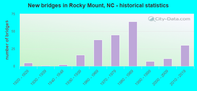
- New bridges - historical statistics
- 51920-1929
- 11930-1939
- 21940-1949
- 161950-1959
- 381960-1969
- 451970-1979
- 641980-1989
- 71990-1999
- 112000-2009
- 302010-2019
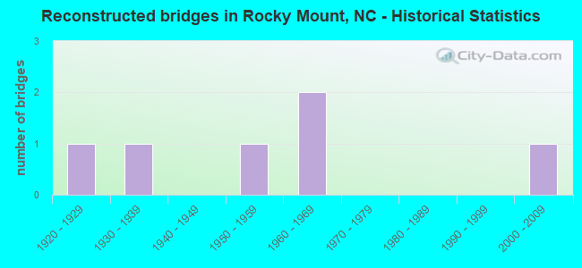
- Reconstructed bridges - Historical Statistics
- 11920-1929
- 11930-1939
- 01940-1949
- 11950-1959
- 21960-1969
- 01970-1979
- 01980-1989
- 01990-1999
- 12000-2009
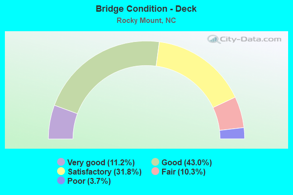
- Bridge Condition - Deck
- 11.2%Very good
- 43.0%Good
- 31.8%Satisfactory
- 10.3%Fair
- 3.7%Poor
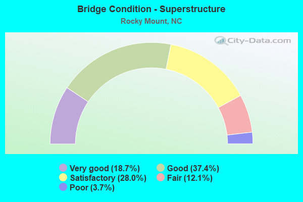
- Bridge Condition - Superstructure
- 18.7%Very good
- 37.4%Good
- 28.0%Satisfactory
- 12.1%Fair
- 3.7%Poor
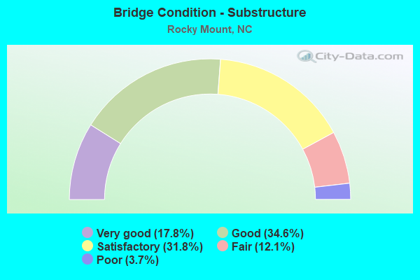
- Bridge Condition - Substructure
- 17.8%Very good
- 34.6%Good
- 31.8%Satisfactory
- 12.1%Fair
- 3.7%Poor
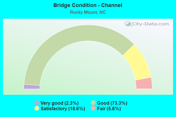
- Bridge Condition - Channel
- 2.3%Very good
- 73.3%Good
- 18.6%Satisfactory
- 5.8%Fair
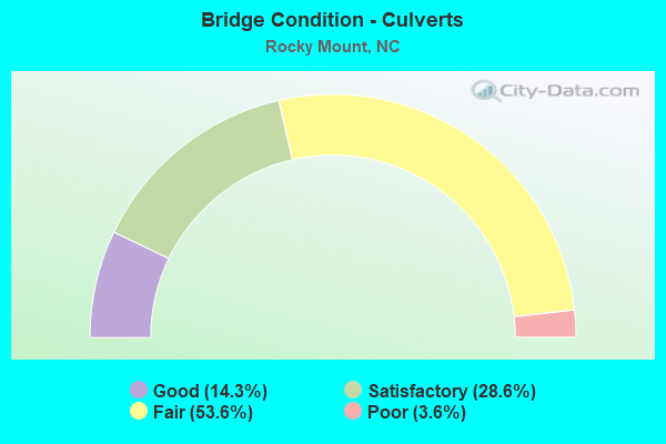
- Bridge Condition - Culverts
- 14.3%Good
- 28.6%Satisfactory
- 53.6%Fair
- 3.6%Poor
Find on map >> Show street view
Structure Number: 1270224, Location: 0.1MI.W. JCT.NC48 (Lat: 36.075025, Lng: -77.813397), Route carried "under" structure: Interstate 95, Year Built: 1966, Structure Length: 0. m, Average Daily Traffic: 17,500 (year 2013), Truck Traffic: 23%, Features Intersected: SR1510
Minimum Vertical Clearance: 5.15m (16.90ft), Kilometerpoint: 0.000, Lanes on structure: 2, Lanes under structure: 2, Material/Design: Steel, Design/Construction: Stringer/Multi-beam, Length of Maximum Span: 22.5m (73.8ft)
Find on map >> Show street view
Structure Number: 1270225, Location: 0.4 MI.E. OF JCT NC4 (Lat: 36.099472, Lng: -77.805608), Route carried "under" structure: Interstate 95, Year Built: 1966, Structure Length: 0. m, Average Daily Traffic: 20,500 (year 2018), Truck Traffic: 23%, Features Intersected: SR1515
Minimum Vertical Clearance: 5.05m (16.57ft), Kilometerpoint: 0.000, Lanes on structure: 2, Lanes under structure: 2, Material/Design: Steel, Design/Construction: Stringer/Multi-beam, Length of Maximum Span: 21.6m (70.9ft)
Find on map >> Show street view
Structure Number: 1270225, Location: 0.4 MI.E. OF JCT NC4 (Lat: 36.099472, Lng: -77.805608), Route carried "under" structure: Interstate 95, Year Built: 1966, Structure Length: 0. m, Average Daily Traffic: 20,500 (year 2018), Truck Traffic: 23%, Features Intersected: SR1515
Minimum Vertical Clearance: 4.96m (16.27ft), Kilometerpoint: 44.958, Lanes on structure: 2, Lanes under structure: 2, Material/Design: Steel, Design/Construction: Stringer/Multi-beam, Length of Maximum Span: 21.6m (70.9ft)
Find on map >> Show street view
Structure Number: 127029, Location: 1.5 MI.E.NC43 (Lat: 35.959203, Lng: -77.790175), Route carried "under" structure: Business US 301, Year Built: 1981, Structure Length: 0. m, Average Daily Traffic: 4,400 (year 2013), Truck Traffic: 12%, Features Intersected: US64E
Minimum Vertical Clearance: 5.90m (19.36ft), Kilometerpoint: 0.000, Lanes on structure: 3, Lanes under structure: 3, Material/Design: Steel, Design/Construction: Stringer/Multi-beam, Length of Maximum Span: 32.3m (106.0ft)
Find on map >> Show street view
Structure Number: 127029, Location: 1.5 MI.E.NC43 (Lat: 35.959203, Lng: -77.790175), Route carried "under" structure: Business US 301, Year Built: 1981, Structure Length: 0. m, Average Daily Traffic: 4,400 (year 2013), Truck Traffic: 12%, Features Intersected: US64E
Minimum Vertical Clearance: 5.63m (18.47ft), Kilometerpoint: 0.000, Lanes on structure: 3, Lanes under structure: 2, Material/Design: Steel, Design/Construction: Stringer/Multi-beam, Length of Maximum Span: 32.3m (106.0ft)
Find on map >> Show street view
Structure Number: 1270291, Location: 0.6 MI. NE. OF NC43 (Lat: 35.959381, Lng: -77.790086), Route carried "under" structure: Business US 301, Year Built: 1981, Structure Length: 0. m, Average Daily Traffic: 4,400 (year 2013), Truck Traffic: 12%, Features Intersected: US64 W
Minimum Vertical Clearance: 5.41m (17.75ft), Kilometerpoint: 0.000, Lanes on structure: 3, Lanes under structure: 3, Material/Design: Steel, Design/Construction: Stringer/Multi-beam, Length of Maximum Span: 32.3m (106.0ft)
Find on map >> Show street view
Structure Number: 1270291, Location: 0.6 MI. NE. OF NC43 (Lat: 35.959381, Lng: -77.790086), Route carried "under" structure: Business US 301, Year Built: 1981, Structure Length: 0. m, Average Daily Traffic: 4,400 (year 2013), Truck Traffic: 12%, Features Intersected: US64 W
Minimum Vertical Clearance: 5.10m (16.73ft), Kilometerpoint: 0.000, Lanes on structure: 3, Lanes under structure: 2, Material/Design: Steel, Design/Construction: Stringer/Multi-beam, Length of Maximum Span: 32.3m (106.0ft)
Find on map >> Show street view
Structure Number: 1270334, Location: 0.6 MI. E. JCT. SR1616 (Lat: 35.967667, Lng: -77.808667), Route carried "under" structure: Bypass US 301, Year Built: 2013, Structure Length: 0. m, Average Daily Traffic: 18,000 (year 2017), Truck Traffic: 12%, Features Intersected: SR1604W
Minimum Vertical Clearance: 6.29m (20.64ft), Kilometerpoint: 0.000, Lanes on structure: 2, Lanes under structure: 2, Material/Design: Steel continuous, Design/Construction: Stringer/Multi-beam, Length of Maximum Span: 32.6m (107.0ft)
Find on map >> Show street view
Structure Number: 1270334, Location: 0.6 MI. E. JCT. SR1616 (Lat: 35.967667, Lng: -77.808667), Route carried "under" structure: Bypass US 301, Year Built: 2013, Structure Length: 0. m, Average Daily Traffic: 18,000 (year 2017), Truck Traffic: 12%, Features Intersected: SR1604W
Minimum Vertical Clearance: 5.89m (19.32ft), Kilometerpoint: 0.000, Lanes on structure: 2, Lanes under structure: 2, Material/Design: Steel continuous, Design/Construction: Stringer/Multi-beam, Length of Maximum Span: 32.6m (107.0ft)
Find on map >> Show street view
Structure Number: 1470504, Location: 1 MI. N. JCT. US13,US26 (Lat: 35.971697, Lng: -77.773100), Route carried "under" structure: State highway 1127, Year Built: 2018, Structure Length: 0. m, Average Daily Traffic: 1,300 (year 2016), Truck Traffic: 6%, Features Intersected: US264N,SW BYP
Minimum Vertical Clearance: 4.87m (15.98ft), Kilometerpoint: 0.000, Lanes on structure: 2, Lanes under structure: 2, Material/Design: Prestressed concrete, Design/Construction: Stringer/Multi-beam, Length of Maximum Span: 35.6m (116.8ft)