Bridge Statistics for Rome, New York (NY)
Condition, Traffic, Stress, Structural Evaluation, Project Costs
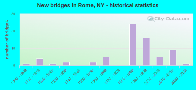
- New bridges - historical statistics
- 11900-1909
- 41910-1919
- 11920-1929
- 21930-1939
- 21950-1959
- 51960-1969
- 241980-1989
- 161990-1999
- 52000-2009
- 92010-2019
- 12020-2022
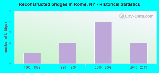
- Reconstructed bridges - Historical Statistics
- 11980-1989
- 21990-1999
- 42000-2009
- 22010-2019
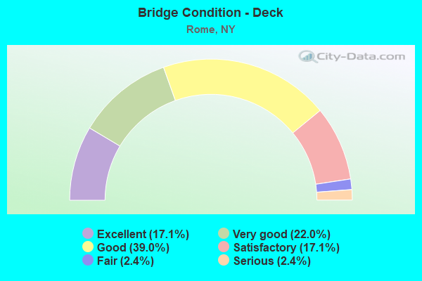
- Bridge Condition - Deck
- 17.1%Excellent
- 22.0%Very good
- 39.0%Good
- 17.1%Satisfactory
- 2.4%Fair
- 2.4%Serious
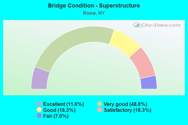
- Bridge Condition - Superstructure
- 11.6%Excellent
- 48.8%Very good
- 16.3%Good
- 16.3%Satisfactory
- 7.0%Fair
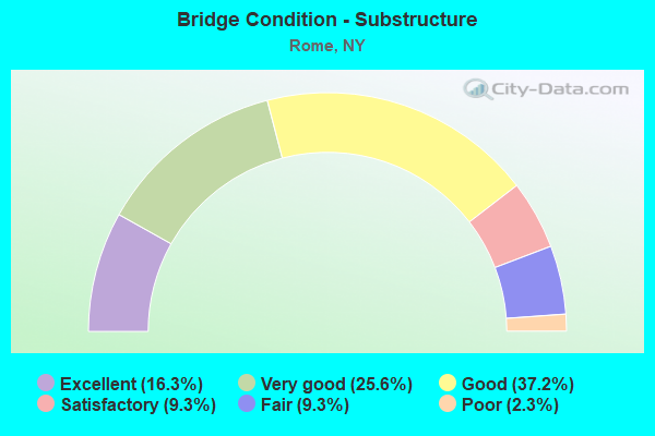
- Bridge Condition - Substructure
- 16.3%Excellent
- 25.6%Very good
- 37.2%Good
- 9.3%Satisfactory
- 9.3%Fair
- 2.3%Poor
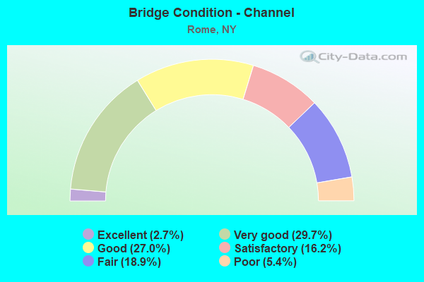
- Bridge Condition - Channel
- 2.7%Excellent
- 29.7%Very good
- 27.0%Good
- 16.2%Satisfactory
- 18.9%Fair
- 5.4%Poor
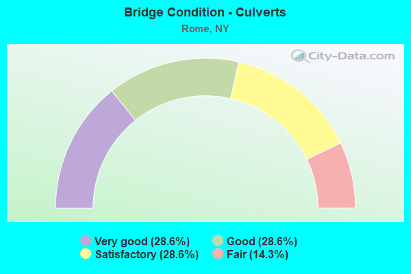
- Bridge Condition - Culverts
- 28.6%Very good
- 28.6%Good
- 28.6%Satisfactory
- 14.3%Fair
Find on map >> Show street view
Structure Number: 101884, Location: 0.8 MI W JCT RTS 233 & 69 (Lat: 43.192008, Lng: -75.452275), Route carried "on" structure: State highway 69, Year Built: 2013, Status: Open, Structure Length: 1.77m (5.81ft), Average Daily Traffic: 9,002 (year 2016), Truck Traffic: 7%, Average Future Daily Traffic: 11,234 (year 2040), Design Load: HL 93, Features Intersected: RTE 365
Minimum Vertical Clearance: 30+ m (98+ ft), Kilometerpoint: 39.935, Lanes on structure: 1, Lanes under structure: 2, Base Highway Network: Yes, Owner: State Highway Agency, Approaching Roadway Width: 8.2m (26.9ft), Skew: 2 degrees, Material/Design: Steel, Design/Construction: Stringer/Multi-beam, Number Of Spans In Main Unit: 1, Length of Maximum Span: 15.7m (51.5ft), Curb-To-Curb Width: 8.2m (26.9ft), Out-to-Out Width: 9.1m (29.9ft)
Condition: Deck: Excellent, Superstructure: Excellent, Substructure: Very good, Operating Rating: 55.3 metric tons, Method Used To Determine Operating Rating: Load Factor (LF), Inventory Rating: 32.7 metric tons, Method Used To Determine Inventory Rating: Load Factor (LF), Structural Evaluation: Equal to present desirable criteria, Deck Geometry: High priority of replacement, Underclear: Meets minimum limits, Approach Roadway Alignment: Equal to present desirable criteria, Length Of Structure Improvement: 1.76m (5.77ft), Designated Inspection Frequency: Every 24 months, Inspection Date: May 2021, Bridge Improvement Cost: $611,000, Roadway Improvement Cost: $358,000, Total Project Cost: $969,000 ( Estimate for 2021), Deck Structure Type: Concrete Cast-file-Place, Wearing Surface/Protective System: Wearing Surface: Integral Concrete, Deck Protection: Epoxy Coated Reinforcing
Find on map >> Show street view
Structure Number: 101885, Location: .6 MI W JCT SH233 & SH 69 (Lat: 43.192264, Lng: -75.448950), Route carried "on" structure: State highway 26, Year Built: 2013, Status: Open, Structure Length: 1.68m (5.51ft), Average Daily Traffic: 9,002 (year 2016), Truck Traffic: 7%, Average Future Daily Traffic: 11,234 (year 2040), Design Load: HL 93, Features Intersected: RTE 365
Minimum Vertical Clearance: 30+ m (98+ ft), Kilometerpoint: 39.935, Lanes on structure: 1, Lanes under structure: 2, Base Highway Network: Yes, Owner: State Highway Agency, Approaching Roadway Width: 8.2m (26.9ft), Material/Design: Steel, Design/Construction: Stringer/Multi-beam, Number Of Spans In Main Unit: 1, Length of Maximum Span: 14.9m (48.9ft), Curb-To-Curb Width: 8.2m (26.9ft), Out-to-Out Width: 9.1m (29.9ft)
Condition: Deck: Excellent, Superstructure: Excellent, Substructure: Very good, Operating Rating: 71.7 metric tons, Method Used To Determine Operating Rating: Load Factor (LF), Inventory Rating: 42.6 metric tons, Method Used To Determine Inventory Rating: Load Factor (LF), Structural Evaluation: Equal to present desirable criteria, Deck Geometry: High priority of replacement, Underclear: High priority of corrective action, Approach Roadway Alignment: Equal to present desirable criteria, Length Of Structure Improvement: 1.67m (5.48ft), Designated Inspection Frequency: Every 24 months, Inspection Date: May 2021, Bridge Improvement Cost: $652,000, Roadway Improvement Cost: $382,000, Total Project Cost: $1,034,000 ( Estimate for 2021), Deck Structure Type: Concrete Cast-file-Place, Wearing Surface/Protective System: Wearing Surface: Integral Concrete, Deck Protection: Epoxy Coated Reinforcing
Find on map >> Show street view
Structure Number: 1018861, Location: 0.4 MI S JCT RTS 49 & 26 (Lat: 43.199908, Lng: -75.453542), Route carried "on" structure: State highway 26, Year Built: 1997, Status: Open, Structure Length: 9.30m (30.51ft), Average Daily Traffic: 2,067 (year 2015), Truck Traffic: 8%, Average Future Daily Traffic: 2,076 (year 2040), Design Load: HS 25 or greater, Features Intersected: MARTIN STREET, CSX TRANS
Minimum Vertical Clearance: 30+ m (98+ ft), Kilometerpoint: 34.835, Lanes on structure: 2, Lanes under structure: 2, Base Highway Network: Yes, Owner: State Highway Agency, Approaching Roadway Width: 11.0m (36.1ft), Skew: 2 degrees, Material/Design: Steel continuous, Design/Construction: Stringer/Multi-beam, Number Of Spans In Main Unit: 2, Length of Maximum Span: 45.7m (149.9ft), Curb-To-Curb Width: 10.8m (35.4ft), Out-to-Out Width: 11.8m (38.7ft)
Condition: Deck: Good, Superstructure: Good, Substructure: Good, Operating Rating: 89.8 metric tons, Method Used To Determine Operating Rating: Load Factor (LF), Inventory Rating: 44.5 metric tons, Method Used To Determine Inventory Rating: Load Factor (LF), Structural Evaluation: Better than present minimum criteria, Deck Geometry: Somewhat better than minimum adequacy, Underclear: Superior to present desirable criteria, Approach Roadway Alignment: Equal to present desirable criteria, Length Of Structure Improvement: 9.29m (30.48ft), Designated Inspection Frequency: Every 24 months, Inspection Date: October 2021, Bridge Improvement Cost: $2,215,000, Roadway Improvement Cost: $1,297,000, Total Project Cost: $3,513,000 ( Estimate for 2021), Deck Structure Type: Concrete Cast-file-Place, Wearing Surface/Protective System: Wearing Surface: Integral Concrete, Deck Protection: Epoxy Coated Reinforcing
Find on map >> Show street view
Structure Number: 1018862, Location: 0.4 MI S JCT RTE 49+26 (Lat: 43.199903, Lng: -75.453356), Route carried "on" structure: State highway 26, Year Built: 1996, Status: Open, Structure Length: 9.30m (30.51ft), Average Daily Traffic: 7,520 (year 2017), Truck Traffic: 6%, Average Future Daily Traffic: 7,555 (year 2040), Design Load: HS 25 or greater, Features Intersected: MARTIN STREET, CSX TRANS
Minimum Vertical Clearance: 30+ m (98+ ft), Kilometerpoint: 35.430, Lanes on structure: 2, Lanes under structure: 2, Base Highway Network: Yes, Owner: State Highway Agency, Approaching Roadway Width: 11.0m (36.1ft), Skew: 2 degrees, Material/Design: Steel continuous, Design/Construction: Stringer/Multi-beam, Number Of Spans In Main Unit: 2, Length of Maximum Span: 45.7m (149.9ft), Curb-To-Curb Width: 11.0m (36.1ft), Out-to-Out Width: 11.8m (38.7ft)
Condition: Deck: Good, Superstructure: Very good, Substructure: Good, Operating Rating: 89.8 metric tons, Method Used To Determine Operating Rating: Load Factor (LF), Inventory Rating: 44.5 metric tons, Method Used To Determine Inventory Rating: Load Factor (LF), Structural Evaluation: Better than present minimum criteria, Deck Geometry: Equal to present minimum criteria, Underclear: Equal to present minimum criteria, Approach Roadway Alignment: Equal to present desirable criteria, Length Of Structure Improvement: 9.29m (30.48ft), Designated Inspection Frequency: Every 24 months, Inspection Date: September 2020, Bridge Improvement Cost: $2,204,000, Roadway Improvement Cost: $1,291,000, Total Project Cost: $3,495,000 ( Estimate for 2021), Deck Structure Type: Concrete Cast-file-Place, Wearing Surface/Protective System: Wearing Surface: Integral Concrete, Deck Protection: Epoxy Coated Reinforcing
Find on map >> Show street view
Structure Number: 102571, Location: 2.7 MI NE JCT RTS 46 & 49 (Lat: 43.224894, Lng: -75.541467), Route carried "on" structure: State highway 46, Year Built: 1982, Status: Open, Structure Length: 2.80m (9.19ft), Average Daily Traffic: 4,715 (year 2018), Truck Traffic: 6%, Average Future Daily Traffic: 4,737 (year 2040), Design Load: HS 20, Features Intersected: WOOD CREEK
Minimum Vertical Clearance: 30+ m (98+ ft), Kilometerpoint: 18.536, Lanes on structure: 2, Base Highway Network: Yes, Owner: State Highway Agency, Approaching Roadway Width: 14.6m (47.9ft), Skew: 4 degrees, Material/Design: Prestressed concrete, Design/Construction: Box Beam or Girders - Multiple, Number Of Spans In Main Unit: 1, Length of Maximum Span: 27.4m (89.9ft), Curb-To-Curb Width: 14.9m (48.9ft), Out-to-Out Width: 15.6m (51.2ft)
Condition: Deck: Very good, Superstructure: Satisfactory, Substructure: Satisfactory, Channel: Very good, Operating Rating: 72.3 metric tons, Method Used To Determine Operating Rating: Load and Resistance Factor Rating (LRFR) rating reported by rating factor(RF) method using HL-93 loadings, Inventory Rating: 44.1 metric tons, Method Used To Determine Inventory Rating: Load and Resistance Factor Rating (LRFR) rating reported by rating factor(RF) method using HL-93 loadings, Structural Evaluation: Equal to present minimum criteria, Deck Geometry: Superior to present desirable criteria, Waterway Adequacy: Equal to present minimum criteria, Approach Roadway Alignment: Equal to present desirable criteria, Length Of Structure Improvement: 2.80m (9.19ft), Designated Inspection Frequency: Every 24 months, Inspection Date: July 2020, Bridge Improvement Cost: $1,108,000, Roadway Improvement Cost: $649,000, Total Project Cost: $1,757,000 ( Estimate for 2021), Wearing Surface/Protective System: Wearing Surface: Bituminous, Membrane: Other
Find on map >> Show street view
Structure Number: 102573, Location: 05MI NWJCT RTS 46+26 (Lat: 43.214644, Lng: -75.470364), Route carried "on" structure: State highway 46, Year Built: 1952, Status: Open, Structure Length: 0.70m (2.30ft), Average Daily Traffic: 17,467 (year 2013), Truck Traffic: 6%, Average Future Daily Traffic: 17,549 (year 2040), Design Load: H 20, Features Intersected: WOOD CREEK
Minimum Vertical Clearance: 30+ m (98+ ft), Kilometerpoint: 25.068, Lanes on structure: 4, Base Highway Network: Yes, Owner: State Highway Agency, Approaching Roadway Width: 20.7m (67.9ft), Skew: 2 degrees, Material/Design: Concrete, Design/Construction: Culvert, Number Of Spans In Main Unit: 1, Length of Maximum Span: 6.0m (19.7ft), Curb or Sidewalk Widths: Left: 1.5m (4.9ft), Right: 1.5m (4.9ft), Curb-To-Curb Width: 20.7m (67.9ft), Out-to-Out Width: 27.4m (89.9ft)
Condition: Channel: Satisfactory, Culverts: Satisfactory, Operating Rating: 74.1 metric tons, Method Used To Determine Operating Rating: Field evaluation and documented engineering judgment, Inventory Rating: 32.7 metric tons, Method Used To Determine Inventory Rating: Field evaluation and documented engineering judgment, Structural Evaluation: Equal to present minimum criteria, Deck Geometry: Superior to present desirable criteria, Waterway Adequacy: Somewhat better than minimum adequacy, Approach Roadway Alignment: Equal to present desirable criteria, Length Of Structure Improvement: 0.70m (2.30ft), Designated Inspection Frequency: Every 24 months, Inspection Date: July 2020, Bridge Improvement Cost: $375,000, Roadway Improvement Cost: $219,000, Total Project Cost: $594,000 ( Estimate for 2021), Wearing Surface/Protective System: Wearing Surface: Bituminous
Find on map >> Show street view
Structure Number: 102574, Location: JCT RTS 46+26 (Lat: 43.209075, Lng: -75.457381), Route carried "on" structure: State highway 26, Year Built: 1960, Status: Open, Structure Length: 1.22m (4.00ft), Average Daily Traffic: 21,433 (year 2004), Truck Traffic: 7%, Average Future Daily Traffic: 30,006 (year 2024), Design Load: HS 20, Features Intersected: RTE 46
Minimum Vertical Clearance: 30+ m (98+ ft), Kilometerpoint: 2.703, Lanes on structure: 2, Lanes under structure: 1, Base Highway Network: Yes, Owner: State Highway Agency, Approaching Roadway Width: 7.3m (24.0ft), Material/Design: Concrete, Design/Construction: Frame, Number Of Spans In Main Unit: 1, Length of Maximum Span: 10.9m (35.8ft), Curb or Sidewalk Widths: Left: 2.3m (7.5ft), Right: 2.3m (7.5ft), Curb-To-Curb Width: 7.3m (24.0ft), Out-to-Out Width: 23.5m (77.1ft)
Condition: Deck: Good, Superstructure: Satisfactory, Substructure: Good, Operating Rating: 80.4 metric tons, Method Used To Determine Operating Rating: Field evaluation and documented engineering judgment, Inventory Rating: 32.7 metric tons, Method Used To Determine Inventory Rating: Field evaluation and documented engineering judgment, Structural Evaluation: Equal to present minimum criteria, Deck Geometry: High priority of replacement, Underclear: Meets minimum limits, Approach Roadway Alignment: Equal to present desirable criteria, Length Of Structure Improvement: 1.21m (3.97ft), Designated Inspection Frequency: Every 24 months, Inspection Date: November 2021, Bridge Improvement Cost: $1,616,000, Roadway Improvement Cost: $946,000, Total Project Cost: $2,562,000 ( Estimate for 2021)
Find on map >> Show street view
Structure Number: 102575, Location: 3.6 MI N JCT RTS 26 & 46 (Lat: 43.263917, Lng: -75.435744), Route carried "on" structure: State highway 46, Year Built: 1991, Status: Open, Structure Length: 3.90m (12.80ft), Average Daily Traffic: 10,179 (year 2018), Truck Traffic: 4%, Average Future Daily Traffic: 12,365 (year 2040), Design Load: HS 20, Features Intersected: MOHAWK RIVER
Minimum Vertical Clearance: 30+ m (98+ ft), Kilometerpoint: 33.194, Lanes on structure: 2, Base Highway Network: Yes, Owner: State Highway Agency, Approaching Roadway Width: 11.0m (36.1ft), Skew: 2 degrees, Material/Design: Steel, Design/Construction: Stringer/Multi-beam, Number Of Spans In Main Unit: 1, Length of Maximum Span: 37.7m (123.7ft), Curb-To-Curb Width: 12.2m (40.0ft), Out-to-Out Width: 12.8m (42.0ft)
Condition: Deck: Good, Superstructure: Good, Substructure: Good, Channel: Good, Operating Rating: 78.9 metric tons, Method Used To Determine Operating Rating: Load Factor (LF), Inventory Rating: 32.7 metric tons, Method Used To Determine Inventory Rating: Load Factor (LF), Structural Evaluation: Better than present minimum criteria, Deck Geometry: Somewhat better than minimum adequacy, Waterway Adequacy: Somewhat better than minimum adequacy, Approach Roadway Alignment: Equal to present desirable criteria, Length Of Structure Improvement: 3.90m (12.80ft), Designated Inspection Frequency: Every 24 months, Inspection Date: June 2021, Bridge Improvement Cost: $1,107,000, Roadway Improvement Cost: $648,000, Total Project Cost: $1,755,000 ( Estimate for 2021), Deck Structure Type: Concrete Cast-file-Place, Wearing Surface/Protective System: Wearing Surface: Integral Concrete, Deck Protection: Epoxy Coated Reinforcing
Find on map >> Show street view
Structure Number: 102576, Location: 4.2 MI N JCT RTS 26 & 46 (Lat: 43.271467, Lng: -75.429814), Route carried "on" structure: State highway 46, Year Built: 1991, Status: Open, Structure Length: 1.62m (5.31ft), Average Daily Traffic: 10,179 (year 2018), Truck Traffic: 4%, Average Future Daily Traffic: 12,365 (year 2040), Design Load: HS 20, Features Intersected: LARKINS CREEK
Minimum Vertical Clearance: 30+ m (98+ ft), Kilometerpoint: 34.175, Lanes on structure: 2, Base Highway Network: Yes, Owner: State Highway Agency, Approaching Roadway Width: 12.2m (40.0ft), Material/Design: Prestressed concrete, Design/Construction: Box Beam or Girders - Multiple, Number Of Spans In Main Unit: 1, Length of Maximum Span: 15.2m (49.9ft), Curb-To-Curb Width: 12.2m (40.0ft), Out-to-Out Width: 12.8m (42.0ft)
Condition: Deck: Very good, Superstructure: Excellent, Substructure: Excellent, Channel: Satisfactory, Operating Rating: 77.1 metric tons, Method Used To Determine Operating Rating: Load Factor (LF), Inventory Rating: 32.7 metric tons, Method Used To Determine Inventory Rating: Load Factor (LF), Structural Evaluation: Superior to present desirable criteria, Deck Geometry: Somewhat better than minimum adequacy, Waterway Adequacy: Somewhat better than minimum adequacy, Approach Roadway Alignment: Equal to present desirable criteria, Length Of Structure Improvement: 1.61m (5.28ft), Designated Inspection Frequency: Every 24 months, Inspection Date: August 2021, Bridge Improvement Cost: $429,000, Roadway Improvement Cost: $251,000, Total Project Cost: $680,000 ( Estimate for 2021), Wearing Surface/Protective System: Wearing Surface: Bituminous, Membrane: Other
Find on map >> Show street view
Structure Number: 102624, Location: JCT NY 365 & NY 49 (Lat: 43.203819, Lng: -75.410544), Route carried "on" structure: Ramp State highway , Year Built: 2005, Status: Open, Structure Length: 5.06m (16.60ft), Average Daily Traffic: 1,597 (year 2017), Truck Traffic: 11%, Average Future Daily Traffic: 1,993 (year 2040), Design Load: HS 25 or greater, Features Intersected: 49 49 26023010 WB, RTE, Facility Carried by Structure: RAMP NY 49EB TO/FM
Minimum Vertical Clearance: 30+ m (98+ ft), Kilometerpoint: 0.660, Lanes on structure: 2, Lanes under structure: 6, Owner: State Highway Agency, Approaching Roadway Width: 15.5m (50.9ft), Skew: 3 degrees, Material/Design: Steel, Design/Construction: Stringer/Multi-beam, Number Of Spans In Main Unit: 1, Length of Maximum Span: 49.2m (161.4ft), Curb-To-Curb Width: 15.6m (51.2ft), Out-to-Out Width: 16.6m (54.5ft)
Condition: Deck: Very good, Superstructure: Very good, Substructure: Very good, Operating Rating: 54.4 metric tons, Method Used To Determine Operating Rating: Load Factor (LF), Inventory Rating: 32.7 metric tons, Method Used To Determine Inventory Rating: Load Factor (LF), Structural Evaluation: Equal to present desirable criteria, Deck Geometry: Superior to present desirable criteria, Underclear: Meets minimum limits, Approach Roadway Alignment: Equal to present desirable criteria, Length Of Structure Improvement: 5.05m (16.57ft), Designated Inspection Frequency: Every 24 months, Inspection Date: June 2021, Bridge Improvement Cost: $1,997,000, Roadway Improvement Cost: $1,169,000, Total Project Cost: $3,167,000 ( Estimate for 2021), Deck Structure Type: Concrete Cast-file-Place, Wearing Surface/Protective System: Wearing Surface: Integral Concrete, Deck Protection: Epoxy Coated Reinforcing
Find on map >> Show street view
Structure Number: 102938, Location: 2.1 MI NW JCT RTS 69 & 46 (Lat: 43.249614, Lng: -75.525889), Route carried "on" structure: State highway 69, Year Built: 1993, Status: Open, Structure Length: 2.53m (8.30ft), Average Daily Traffic: 8,857 (year 2020), Truck Traffic: 7%, Average Future Daily Traffic: 10,759 (year 2040), Design Load: HS 20, Features Intersected: CANADA CREEK
Minimum Vertical Clearance: 30+ m (98+ ft), Kilometerpoint: 32.180, Lanes on structure: 2, Base Highway Network: Yes, Owner: State Highway Agency, Approaching Roadway Width: 11.0m (36.1ft), Material/Design: Steel, Design/Construction: Stringer/Multi-beam, Number Of Spans In Main Unit: 1, Length of Maximum Span: 24.3m (79.7ft), Curb-To-Curb Width: 11.0m (36.1ft), Out-to-Out Width: 11.6m (38.1ft)
Condition: Deck: Very good, Superstructure: Good, Substructure: Very good, Channel: Good, Operating Rating: 82.6 metric tons, Method Used To Determine Operating Rating: Load Factor (LF), Inventory Rating: 49.0 metric tons, Method Used To Determine Inventory Rating: Load Factor (LF), Structural Evaluation: Better than present minimum criteria, Deck Geometry: Meets minimum limits, Waterway Adequacy: Somewhat better than minimum adequacy, Approach Roadway Alignment: Equal to present desirable criteria, Length Of Structure Improvement: 2.52m (8.27ft), Designated Inspection Frequency: Every 24 months, Inspection Date: June 2021, Bridge Improvement Cost: $554,000, Roadway Improvement Cost: $324,000, Total Project Cost: $878,000 ( Estimate for 2021), Deck Structure Type: Concrete Cast-file-Place, Wearing Surface/Protective System: Wearing Surface: Bituminous, Deck Protection: Epoxy Coated Reinforcing
Find on map >> Show street view
Structure Number: 1069641, Location: 0.6 MI W JCT RTS 49 & 365 (Lat: 43.204217, Lng: -75.423631), Route carried "on" structure: State highway 49, Year Built: 1980, Year Reconstructed: 2014, Status: Open, Structure Length: 3.23m (10.60ft), Average Daily Traffic: 5,710 (year 2020), Truck Traffic: 13%, Average Future Daily Traffic: 7,126 (year 2040), Design Load: HS 20, Features Intersected: SERVICE (LADO) RO
Minimum Vertical Clearance: 30+ m (98+ ft), Kilometerpoint: 43.041, Lanes on structure: 2, Lanes under structure: 4, Base Highway Network: Yes, Owner: State Highway Agency, Approaching Roadway Width: 12.5m (41.0ft), Material/Design: Prestressed concrete, Design/Construction: Box Beam or Girders - Multiple, Number Of Spans In Main Unit: 1, Length of Maximum Span: 32.0m (105.0ft), Curb-To-Curb Width: 12.5m (41.0ft), Out-to-Out Width: 13.8m (45.3ft)
Condition: Deck: Satisfactory, Superstructure: Satisfactory, Substructure: Good, Operating Rating: 92.5 metric tons, Method Used To Determine Operating Rating: Load Factor (LF), Inventory Rating: 50.8 metric tons, Method Used To Determine Inventory Rating: Load Factor (LF), Structural Evaluation: Equal to present minimum criteria, Underclear: Somewhat better than minimum adequacy, Approach Roadway Alignment: Equal to present desirable criteria, Length Of Structure Improvement: 3.23m (10.60ft), Designated Inspection Frequency: Every 24 months, Inspection Date: April 2020, Bridge Improvement Cost: $1,110,000, Roadway Improvement Cost: $650,000, Total Project Cost: $1,760,000 ( Estimate for 2021), Wearing Surface/Protective System: Wearing Surface: Latex Concrete
Find on map >> Show street view
Structure Number: 1069642, Location: .6 MI W JCT SH 49 & SH365 (Lat: 43.204050, Lng: -75.423603), Route carried "on" structure: State highway 49, Year Built: 1980, Year Reconstructed: 2014, Status: Open, Structure Length: 3.29m (10.79ft), Average Daily Traffic: 5,710 (year 2020), Truck Traffic: 13%, Average Future Daily Traffic: 7,126 (year 2040), Design Load: HS 20, Features Intersected: SERVICE (LADO) RO
Minimum Vertical Clearance: 30+ m (98+ ft), Kilometerpoint: 43.041, Lanes on structure: 2, Lanes under structure: 4, Base Highway Network: Yes, Owner: State Highway Agency, Approaching Roadway Width: 12.5m (41.0ft), Material/Design: Prestressed concrete, Design/Construction: Box Beam or Girders - Multiple, Number Of Spans In Main Unit: 1, Length of Maximum Span: 32.0m (105.0ft), Curb-To-Curb Width: 12.5m (41.0ft), Out-to-Out Width: 13.8m (45.3ft)
Condition: Deck: Satisfactory, Superstructure: Satisfactory, Substructure: Good, Operating Rating: 92.5 metric tons, Method Used To Determine Operating Rating: Load Factor (LF), Inventory Rating: 50.8 metric tons, Method Used To Determine Inventory Rating: Load Factor (LF), Structural Evaluation: Equal to present minimum criteria, Underclear: Equal to present minimum criteria, Approach Roadway Alignment: Equal to present desirable criteria, Length Of Structure Improvement: 3.29m (10.79ft), Designated Inspection Frequency: Every 24 months, Inspection Date: April 2020, Bridge Improvement Cost: $1,137,000, Roadway Improvement Cost: $666,000, Total Project Cost: $1,803,000 ( Estimate for 2021), Wearing Surface/Protective System: Wearing Surface: Latex Concrete
Find on map >> Show street view
Structure Number: 106975, Location: SE CORNER OF ROME (Lat: 43.204869, Lng: -75.410908), Route carried "on" structure: Ramp State highway , Year Built: 1980, Status: Open, Structure Length: 3.51m (11.52ft), Average Daily Traffic: 1,597 (year 2017), Truck Traffic: 11%, Average Future Daily Traffic: 1,993 (year 2040), Design Load: HS 20, Features Intersected: RTE 365, Facility Carried by Structure: Alternate Other road 5 825
Minimum Vertical Clearance: 30+ m (98+ ft), Kilometerpoint: 0.772, Lanes on structure: 3, Lanes under structure: 2, Owner: State Highway Agency, Approaching Roadway Width: 16.8m (55.1ft), Skew: 3 degrees, Material/Design: Steel, Design/Construction: Stringer/Multi-beam, Number Of Spans In Main Unit: 2, Length of Maximum Span: 21.6m (70.9ft), Curb-To-Curb Width: 16.6m (54.5ft), Out-to-Out Width: 17.5m (57.4ft)
Condition: Deck: Satisfactory, Superstructure: Very good, Substructure: Fair, Operating Rating: 80.8 metric tons, Method Used To Determine Operating Rating: Field evaluation and documented engineering judgment, Inventory Rating: 32.7 metric tons, Method Used To Determine Inventory Rating: Field evaluation and documented engineering judgment, Structural Evaluation: Somewhat better than minimum adequacy, Deck Geometry: Superior to present desirable criteria, Underclear: High priority of corrective action, Approach Roadway Alignment: Equal to present desirable criteria, Length Of Structure Improvement: 3.50m (11.48ft), Designated Inspection Frequency: Every 24 months, Inspection Date: May 2020, Bridge Improvement Cost: $1,454,000, Roadway Improvement Cost: $852,000, Total Project Cost: $2,306,000 ( Estimate for 2021), Deck Structure Type: Concrete Cast-file-Place, Wearing Surface/Protective System: Wearing Surface: Integral Concrete
Find on map >> Show street view
Structure Number: 106976, Location: CITY OF ROME NY (Lat: 43.204969, Lng: -75.411453), Route carried "on" structure: Ramp Other road , Year Built: 1980, Status: Open, Structure Length: 2.90m (9.51ft), Average Daily Traffic: 1,616 (year 2017), Truck Traffic: 12%, Average Future Daily Traffic: 2,016 (year 2040), Design Load: HS 20, Features Intersected: RTE 365, Facility Carried by Structure: RAMP FM NY 825 TO
Minimum Vertical Clearance: 30+ m (98+ ft), Kilometerpoint: 0.145, Lanes on structure: 1, Lanes under structure: 2, Owner: State Highway Agency, Approaching Roadway Width: 7.3m (24.0ft), Material/Design: Steel, Design/Construction: Stringer/Multi-beam, Number Of Spans In Main Unit: 1, Length of Maximum Span: 28.3m (92.8ft), Curb-To-Curb Width: 7.3m (24.0ft), Out-to-Out Width: 8.3m (27.2ft)
Condition: Deck: Fair, Superstructure: Very good, Substructure: Good, Operating Rating: 71.7 metric tons, Method Used To Determine Operating Rating: Load Factor (LF), Inventory Rating: 42.6 metric tons, Method Used To Determine Inventory Rating: Load Factor (LF), Structural Evaluation: Better than present minimum criteria, Deck Geometry: Better than present minimum criteria, Underclear: Somewhat better than minimum adequacy, Approach Roadway Alignment: Equal to present desirable criteria, Length Of Structure Improvement: 2.89m (9.48ft), Designated Inspection Frequency: Every 24 months, Critical Feature Inspection Frequency: Every 24 months, Inspection Date: May 2020, Critical Feature Inspection Date: May 2020, Bridge Improvement Cost: $631,000, Roadway Improvement Cost: $370,000, Total Project Cost: $1,001,000 ( Estimate for 2021), Deck Structure Type: Concrete Cast-file-Place, Wearing Surface/Protective System: Wearing Surface: Integral Concrete
Find on map >> Show street view
Structure Number: 106979, Location: W JCT ROME ART & SH 233 (Lat: 43.194153, Lng: -75.441442), Route carried "on" structure: Ramp Other road , Year Built: 1980, Status: Open, Structure Length: 2.38m (7.81ft), Average Daily Traffic: 1,081 (year 2017), Truck Traffic: 7%, Average Future Daily Traffic: 1,349 (year 2040), Design Load: HS 20, Features Intersected: WHEELER CREEK, Facility Carried by Structure: RAMP RTE 233 to RT
Minimum Vertical Clearance: 30+ m (98+ ft), Kilometerpoint: 0.193, Lanes on structure: 1, Owner: State Highway Agency, Approaching Roadway Width: 7.6m (24.9ft), Skew: 2 degrees, Material/Design: Prestressed concrete, Design/Construction: Box Beam or Girders - Multiple, Number Of Spans In Main Unit: 1, Length of Maximum Span: 22.2m (72.8ft), Curb-To-Curb Width: 7.6m (24.9ft), Out-to-Out Width: 8.8m (28.9ft)
Condition: Deck: Satisfactory, Superstructure: Good, Substructure: Good, Channel: Very good, Inventory Rating: 62.6 metric tons, Method Used To Determine Inventory Rating: Load Factor (LF), Structural Evaluation: Better than present minimum criteria, Deck Geometry: Better than present minimum criteria, Waterway Adequacy: Equal to present minimum criteria, Approach Roadway Alignment: Equal to present desirable criteria, Length Of Structure Improvement: 2.37m (7.78ft), Designated Inspection Frequency: Every 24 months, Inspection Date: May 2020, Bridge Improvement Cost: $473,000, Roadway Improvement Cost: $277,000, Total Project Cost: $750,000 ( Estimate for 2021), Wearing Surface/Protective System: Wearing Surface: Bituminous, Membrane: Preformed Fabric
Find on map >> Show street view
Structure Number: 10698, Location: W OF JCT ROME ART&RTE 233 (Lat: 43.194086, Lng: -75.440764), Route carried "on" structure: Ramp Other road , Year Built: 1980, Year Reconstructed: 2019, Status: Open, Structure Length: 3.05m (10.01ft), Average Daily Traffic: 1,088 (year 2017), Truck Traffic: 10%, Average Future Daily Traffic: 1,357 (year 2040), Design Load: HL 93, Features Intersected: WHEELER CREEK, Facility Carried by Structure: RAMP FM NY 49WB TO
Minimum Vertical Clearance: 30+ m (98+ ft), Kilometerpoint: 0.290, Lanes on structure: 1, Owner: State Highway Agency, Approaching Roadway Width: 7.6m (24.9ft), Material/Design: Steel, Design/Construction: Stringer/Multi-beam, Number Of Spans In Main Unit: 1, Length of Maximum Span: 29.8m (97.8ft), Curb-To-Curb Width: 7.6m (24.9ft), Out-to-Out Width: 8.7m (28.5ft)
Condition: Deck: Excellent, Superstructure: Very good, Substructure: Excellent, Channel: Very good, Operating Rating: 93.9 metric tons, Method Used To Determine Operating Rating: Field evaluation and documented engineering judgment, Inventory Rating: 32.7 metric tons, Method Used To Determine Inventory Rating: Field evaluation and documented engineering judgment, Structural Evaluation: Equal to present desirable criteria, Deck Geometry: Better than present minimum criteria, Waterway Adequacy: Equal to present minimum criteria, Approach Roadway Alignment: Equal to present desirable criteria, Length Of Structure Improvement: 3.04m (9.97ft), Designated Inspection Frequency: Every 24 months, Critical Feature Inspection Frequency: Every 24 months, Inspection Date: June 2020, Critical Feature Inspection Date: June 2020, Bridge Improvement Cost: $587,000, Roadway Improvement Cost: $344,000, Total Project Cost: $931,000 ( Estimate for 2021), Deck Structure Type: Concrete Cast-file-Place, Wearing Surface/Protective System: Wearing Surface: Integral Concrete, Deck Protection: Epoxy Coated Reinforcing
Find on map >> Show street view
Structure Number: 106981, Location: N OF JCT ROME ART&RTE 233 (Lat: 43.194453, Lng: -75.437506), Route carried "on" structure: State highway 233, Year Built: 1980, Year Reconstructed: 2019, Status: Open, Structure Length: 2.35m (7.71ft), Average Daily Traffic: 7,759 (year 2018), Truck Traffic: 5%, Average Future Daily Traffic: 9,600 (year 2040), Design Load: HL 93, Features Intersected: WHEELER CREEK
Minimum Vertical Clearance: 30+ m (98+ ft), Kilometerpoint: 19.131, Lanes on structure: 3, Base Highway Network: Yes, Owner: State Highway Agency, Approaching Roadway Width: 21.3m (69.9ft), Skew: 2 degrees, Material/Design: Prestressed concrete, Design/Construction: Box Beam or Girders - Multiple, Number Of Spans In Main Unit: 1, Length of Maximum Span: 21.9m (71.9ft), Curb or Sidewalk Widths: Left: 4.0m (13.1ft), Right: 0.0m, Curb-To-Curb Width: 17.4m (57.1ft), Out-to-Out Width: 22.7m (74.5ft)
Condition: Deck: Very good, Superstructure: Satisfactory, Substructure: Very good, Channel: Very good, Operating Rating: 59.0 metric tons, Method Used To Determine Operating Rating: Load Factor (LF), Inventory Rating: 28.1 metric tons, Method Used To Determine Inventory Rating: Load Factor (LF), Structural Evaluation: Equal to present minimum criteria, Deck Geometry: Superior to present desirable criteria, Waterway Adequacy: Equal to present desirable criteria, Approach Roadway Alignment: Equal to present desirable criteria, Length Of Structure Improvement: 2.34m (7.68ft), Designated Inspection Frequency: Every 24 months, Inspection Date: April 2020, Bridge Improvement Cost: $1,316,000, Roadway Improvement Cost: $771,000, Total Project Cost: $2,087,000 ( Estimate for 2021), Wearing Surface/Protective System: Wearing Surface: Monolithic Concrete
Find on map >> Show street view
Structure Number: 1070031, Location: JCT ROME ART & SH 233 (Lat: 43.194106, Lng: -75.437192), Route carried "on" structure: State highway 49, Year Built: 1980, Status: Open, Structure Length: 4.11m (13.48ft), Average Daily Traffic: 7,136 (year 2020), Truck Traffic: 13%, Average Future Daily Traffic: 8,905 (year 2040), Design Load: HS 20, Features Intersected: RTE 233
Minimum Vertical Clearance: 30+ m (98+ ft), Kilometerpoint: 41.255, Lanes on structure: 3, Lanes under structure: 3, Base Highway Network: Yes, Owner: State Highway Agency, Approaching Roadway Width: 16.2m (53.1ft), Skew: 1 degrees, Material/Design: Steel, Design/Construction: Stringer/Multi-beam, Number Of Spans In Main Unit: 1, Length of Maximum Span: 39.6m (129.9ft), Curb-To-Curb Width: 16.2m (53.1ft), Out-to-Out Width: 17.1m (56.1ft)
Condition: Deck: Good, Superstructure: Very good, Substructure: Satisfactory, Operating Rating: 84.9 metric tons, Method Used To Determine Operating Rating: Load and Resistance Factor Rating (LRFR) rating reported by rating factor(RF) method using HL-93 loadings, Inventory Rating: 65.4 metric tons, Method Used To Determine Inventory Rating: Load and Resistance Factor Rating (LRFR) rating reported by rating factor(RF) method using HL-93 loadings, Structural Evaluation: Equal to present minimum criteria, Deck Geometry: Equal to present minimum criteria, Underclear: Equal to present minimum criteria, Approach Roadway Alignment: Equal to present desirable criteria, Length Of Structure Improvement: 4.11m (13.48ft), Designated Inspection Frequency: Every 24 months, Inspection Date: April 2020, Bridge Improvement Cost: $1,467,000, Roadway Improvement Cost: $859,000, Total Project Cost: $2,327,000 ( Estimate for 2021), Deck Structure Type: Concrete Cast-file-Place, Wearing Surface/Protective System: Wearing Surface: Monolithic Concrete, Deck Protection: Epoxy Coated Reinforcing
Find on map >> Show street view
Structure Number: 1070032, Location: JCT ROME ART & SH 233 (Lat: 43.193944, Lng: -75.437042), Route carried "on" structure: State highway 49, Year Built: 1980, Status: Open, Structure Length: 4.11m (13.48ft), Average Daily Traffic: 7,136 (year 2020), Truck Traffic: 13%, Average Future Daily Traffic: 8,905 (year 2040), Design Load: HS 20, Features Intersected: RTE 233
Minimum Vertical Clearance: 30+ m (98+ ft), Kilometerpoint: 41.255, Lanes on structure: 2, Lanes under structure: 3, Base Highway Network: Yes, Owner: State Highway Agency, Approaching Roadway Width: 12.5m (41.0ft), Skew: 1 degrees, Material/Design: Steel, Design/Construction: Stringer/Multi-beam, Number Of Spans In Main Unit: 1, Length of Maximum Span: 39.6m (129.9ft), Curb-To-Curb Width: 12.5m (41.0ft), Out-to-Out Width: 13.4m (44.0ft)
Condition: Deck: Good, Superstructure: Very good, Substructure: Satisfactory, Operating Rating: 87.2 metric tons, Method Used To Determine Operating Rating: Load and Resistance Factor Rating (LRFR) rating reported by rating factor(RF) method using HL-93 loadings, Inventory Rating: 67.4 metric tons, Method Used To Determine Inventory Rating: Load and Resistance Factor Rating (LRFR) rating reported by rating factor(RF) method using HL-93 loadings, Structural Evaluation: Equal to present minimum criteria, Deck Geometry: Better than present minimum criteria, Underclear: Equal to present minimum criteria, Approach Roadway Alignment: Equal to present desirable criteria, Length Of Structure Improvement: 4.11m (13.48ft), Designated Inspection Frequency: Every 24 months, Inspection Date: April 2020, Bridge Improvement Cost: $1,165,000, Roadway Improvement Cost: $682,000, Total Project Cost: $1,848,000 ( Estimate for 2021), Deck Structure Type: Concrete Cast-file-Place, Wearing Surface/Protective System: Wearing Surface: Latex Concrete, Deck Protection: Epoxy Coated Reinforcing
Find on map >> Show street view
Structure Number: 1090431, Location: 0.4 MI W JCT RTS 69 & 233 (Lat: 43.192981, Lng: -75.443331), Route carried "on" structure: State highway 49, Year Built: 1999, Status: Open, Structure Length: 1.28m (4.20ft), Average Daily Traffic: 9,795 (year 2011), Truck Traffic: 13%, Average Future Daily Traffic: 10,363 (year 2038), Design Load: HS 25 or greater, Features Intersected: WHEELER CREEK
Minimum Vertical Clearance: 30+ m (98+ ft), Kilometerpoint: 40.482, Lanes on structure: 3, Base Highway Network: Yes, Owner: State Highway Agency, Approaching Roadway Width: 18.6m (61.0ft), Skew: 5 degrees, Material/Design: Concrete, Design/Construction: Culvert, Number Of Spans In Main Unit: 1, Length of Maximum Span: 11.9m (39.0ft)
Condition: Channel: Good, Culverts: Very good, Operating Rating: 81.0 metric tons, Method Used To Determine Operating Rating: Field evaluation and documented engineering judgment, Inventory Rating: 40.8 metric tons, Method Used To Determine Inventory Rating: Field evaluation and documented engineering judgment, Structural Evaluation: Equal to present desirable criteria, Waterway Adequacy: Superior to present desirable criteria, Approach Roadway Alignment: Equal to present desirable criteria, Length Of Structure Improvement: 1.28m (4.20ft), Designated Inspection Frequency: Every 24 months, Inspection Date: May 2021, Bridge Improvement Cost: $965,000, Roadway Improvement Cost: $565,000, Total Project Cost: $1,531,000 ( Estimate for 2021)
Find on map >> Show street view
Structure Number: 1090432, Location: 0.4 MI W JCT RTS 69 & 233 (Lat: 43.191656, Lng: -75.444567), Route carried "on" structure: State highway 49, Year Built: 1999, Status: Open, Structure Length: 1.13m (3.71ft), Average Daily Traffic: 9,795 (year 2011), Truck Traffic: 13%, Average Future Daily Traffic: 10,363 (year 2038), Design Load: HS 25 or greater, Features Intersected: WHEELER CREEK
Minimum Vertical Clearance: 30+ m (98+ ft), Kilometerpoint: 40.482, Lanes on structure: 2, Base Highway Network: Yes, Owner: State Highway Agency, Approaching Roadway Width: 12.5m (41.0ft), Skew: 4 degrees, Material/Design: Concrete, Design/Construction: Culvert, Number Of Spans In Main Unit: 1, Length of Maximum Span: 10.4m (34.1ft)
Condition: Channel: Good, Culverts: Very good, Operating Rating: 79.9 metric tons, Method Used To Determine Operating Rating: Field evaluation and documented engineering judgment, Inventory Rating: 40.8 metric tons, Method Used To Determine Inventory Rating: Field evaluation and documented engineering judgment, Structural Evaluation: Equal to present desirable criteria, Waterway Adequacy: High priority of corrective action, Approach Roadway Alignment: Equal to present desirable criteria, Length Of Structure Improvement: 1.12m (3.67ft), Designated Inspection Frequency: Every 24 months, Inspection Date: May 2021, Bridge Improvement Cost: $573,000, Roadway Improvement Cost: $336,000, Total Project Cost: $909,000 ( Estimate for 2021)
Find on map >> Show street view
Structure Number: 109419, Location: 08MI W JCT RTS 233+69 (Lat: 43.190633, Lng: -75.449625), Route carried "on" structure: State highway 69, Year Built: 2013, Status: Open, Structure Length: 1.62m (5.31ft), Average Daily Traffic: 16,067 (year 2011), Truck Traffic: 13%, Average Future Daily Traffic: 20,051 (year 2040), Design Load: HL 93, Features Intersected: RTE 26
Minimum Vertical Clearance: 30+ m (98+ ft), Kilometerpoint: 40.209, Lanes on structure: 1, Lanes under structure: 1, Base Highway Network: Yes, Owner: State Highway Agency, Approaching Roadway Width: 8.2m (26.9ft), Skew: 2 degrees, Material/Design: Steel, Design/Construction: Stringer/Multi-beam, Number Of Spans In Main Unit: 1, Length of Maximum Span: 14.0m (45.9ft), Curb-To-Curb Width: 8.2m (26.9ft), Out-to-Out Width: 9.1m (29.9ft)
Condition: Deck: Very good, Superstructure: Very good, Substructure: Very good, Operating Rating: 67.1 metric tons, Method Used To Determine Operating Rating: Load Factor (LF), Inventory Rating: 39.9 metric tons, Method Used To Determine Inventory Rating: Load Factor (LF), Structural Evaluation: Equal to present desirable criteria, Deck Geometry: High priority of replacement, Underclear: Meets minimum limits, Approach Roadway Alignment: Equal to present desirable criteria, Length Of Structure Improvement: 1.61m (5.28ft), Designated Inspection Frequency: Every 24 months, Inspection Date: May 2021, Bridge Improvement Cost: $628,000, Roadway Improvement Cost: $368,000, Total Project Cost: $996,000 ( Estimate for 2021), Deck Structure Type: Concrete Cast-file-Place, Wearing Surface/Protective System: Wearing Surface: Integral Concrete, Deck Protection: Epoxy Coated Reinforcing
Find on map >> Show street view
Structure Number: 220635, Location: 2.5 MI W OF ROME (Lat: 43.223558, Lng: -75.536489), Route carried "on" structure: City street , Year Built: 2021, Status: Open, Structure Length: 3.11m (10.20ft), Average Daily Traffic: 35 (year 2019), Truck Traffic: 7%, Average Future Daily Traffic: 49 (year 2039), Design Load: HS 20, Features Intersected: WOOD CREEK, Facility Carried by Structure: SEIFERT ROAD
Minimum Vertical Clearance: 30+ m (98+ ft), Kilometerpoint: 2.301, Lanes on structure: 2, Owner: City or Municipal Highway Agency, Approaching Roadway Width: 8.5m (27.9ft), Skew: 3 degrees, Material/Design: Steel, Design/Construction: Stringer/Multi-beam, Number Of Spans In Main Unit: 1, Length of Maximum Span: 30.8m (101.0ft), Curb-To-Curb Width: 9.0m (29.5ft), Out-to-Out Width: 10.1m (33.1ft)
Condition: Deck: Excellent, Superstructure: Excellent, Substructure: Excellent, Channel: Very good, Operating Rating: 80.7 metric tons, Method Used To Determine Operating Rating: Load Factor (LF), Inventory Rating: 48.1 metric tons, Method Used To Determine Inventory Rating: Load Factor (LF), Structural Evaluation: Superior to present desirable criteria, Deck Geometry: Better than present minimum criteria, Waterway Adequacy: Meets minimum limits, Approach Roadway Alignment: Better than present minimum criteria, Length Of Structure Improvement: 2.19m (7.19ft), Designated Inspection Frequency: Every 24 months, Inspection Date: December 2021, Bridge Improvement Cost: $504,000, Roadway Improvement Cost: $295,000, Total Project Cost: $799,000 ( Estimate for 2021), Wearing Surface/Protective System: Wearing Surface: Integral Concrete
Find on map >> Show street view
Structure Number: 220636, Location: 3.0 MI NW OF ROME (Lat: 43.229622, Lng: -75.539967), Route carried "on" structure: City street , Year Built: 2011, Status: Open, Structure Length: 2.07m (6.79ft), Average Daily Traffic: 716 (year 2017), Truck Traffic: 6%, Average Future Daily Traffic: 1,002 (year 2037), Design Load: HS 25 or greater, Features Intersected: CANADA CREEK, Facility Carried by Structure: TANNERY ROAD
Minimum Vertical Clearance: 30+ m (98+ ft), Kilometerpoint: 0.370, Lanes on structure: 2, Owner: County Highway Agency, Approaching Roadway Width: 9.1m (29.9ft), Skew: 1 degrees, Material/Design: Prestressed concrete, Design/Construction: Box Beam or Girders - Multiple, Number Of Spans In Main Unit: 1, Length of Maximum Span: 19.2m (63.0ft), Curb-To-Curb Width: 9.1m (29.9ft), Out-to-Out Width: 10.2m (33.5ft)
Condition: Deck: Good, Superstructure: Very good, Substructure: Excellent, Channel: Good, Operating Rating: 87.1 metric tons, Method Used To Determine Operating Rating: Load Factor (LF), Inventory Rating: 43.5 metric tons, Method Used To Determine Inventory Rating: Load Factor (LF), Structural Evaluation: Equal to present desirable criteria, Deck Geometry: Equal to present minimum criteria, Waterway Adequacy: Somewhat better than minimum adequacy, Approach Roadway Alignment: Better than present minimum criteria, Length Of Structure Improvement: 2.07m (6.79ft), Designated Inspection Frequency: Every 24 months, Inspection Date: August 2021, Bridge Improvement Cost: $416,000, Roadway Improvement Cost: $244,000, Total Project Cost: $660,000 ( Estimate for 2021), Deck Structure Type: Concrete Cast-file-Place, Wearing Surface/Protective System: Wearing Surface: Integral Concrete, Deck Protection: Epoxy Coated Reinforcing
Find on map >> Show street view
Structure Number: 220637, Location: 4.5 MI NW OF ROME (Lat: 43.227031, Lng: -75.543217), Route carried "on" structure: Other road , Year Built: 2002, Status: Open, Structure Length: 2.47m (8.10ft), Average Daily Traffic: 1,105 (year 2016), Truck Traffic: 4%, Average Future Daily Traffic: 1,547 (year 2036), Design Load: HS 20, Features Intersected: CANADA CREEK, Facility Carried by Structure: OSWEGO ROAD
Minimum Vertical Clearance: 30+ m (98+ ft), Kilometerpoint: 6.854, Lanes on structure: 2, Owner: County Highway Agency, Approaching Roadway Width: 7.3m (24.0ft), Material/Design: Concrete, Design/Construction: Box Beam or Girders - Multiple, Number Of Spans In Main Unit: 1, Length of Maximum Span: 23.4m (76.8ft), Curb-To-Curb Width: 8.6m (28.2ft), Out-to-Out Width: 9.6m (31.5ft)
Condition: Deck: Satisfactory, Superstructure: Good, Substructure: Very good, Channel: Good, Inventory Rating: 61.7 metric tons, Method Used To Determine Inventory Rating: Load Factor (LF), Structural Evaluation: Better than present minimum criteria, Deck Geometry: Somewhat better than minimum adequacy, Waterway Adequacy: Somewhat better than minimum adequacy, Approach Roadway Alignment: Better than present minimum criteria, Length Of Structure Improvement: 2.46m (8.07ft), Designated Inspection Frequency: Every 24 months, Inspection Date: September 2020, Bridge Improvement Cost: $543,000, Roadway Improvement Cost: $318,000, Total Project Cost: $861,000 ( Estimate for 2021), Deck Structure Type: Concrete Cast-file-Place, Wearing Surface/Protective System: Wearing Surface: Monolithic Concrete, Deck Protection: Epoxy Coated Reinforcing
Find on map >> Show street view
Structure Number: 220638, Location: 2.5 MI W OF ROME (Lat: 43.241172, Lng: -75.531517), Route carried "on" structure: City street , Year Built: 2013, Status: Open, Structure Length: 1.98m (6.50ft), Average Daily Traffic: 716 (year 2017), Truck Traffic: 6%, Average Future Daily Traffic: 1,002 (year 2037), Design Load: HS 25 or greater, Features Intersected: CANADA CREEK, Facility Carried by Structure: TANNERY ROAD
Minimum Vertical Clearance: 30+ m (98+ ft), Kilometerpoint: 1.931, Lanes on structure: 2, Owner: City or Municipal Highway Agency, Approaching Roadway Width: 8.8m (28.9ft), Material/Design: Prestressed concrete, Design/Construction: Box Beam or Girders - Multiple, Number Of Spans In Main Unit: 1, Length of Maximum Span: 18.3m (60.0ft), Curb-To-Curb Width: 8.8m (28.9ft), Out-to-Out Width: 9.9m (32.5ft)
Condition: Deck: Excellent, Superstructure: Excellent, Substructure: Excellent, Channel: Very good, Operating Rating: 50.5 metric tons, Method Used To Determine Operating Rating: Load and Resistance Factor Rating (LRFR) rating reported by rating factor(RF) method using HL-93 loadings, Inventory Rating: 38.9 metric tons, Method Used To Determine Inventory Rating: Load and Resistance Factor Rating (LRFR) rating reported by rating factor(RF) method using HL-93 loadings, Structural Evaluation: Superior to present desirable criteria, Deck Geometry: Somewhat better than minimum adequacy, Waterway Adequacy: Equal to present minimum criteria, Approach Roadway Alignment: Equal to present minimum criteria, Length Of Structure Improvement: 1.98m (6.50ft), Designated Inspection Frequency: Every 24 months, Inspection Date: October 2021, Bridge Improvement Cost: $415,000, Roadway Improvement Cost: $243,000, Total Project Cost: $658,000 ( Estimate for 2021)
Find on map >> Show street view
Structure Number: 22064, Location: 3 MI SW OF ROME (Lat: 43.181172, Lng: -75.523442), Route carried "on" structure: City street , Year Built: 1939, Year Reconstructed: 1980, Status: Open, Structure Length: 0.79m (2.59ft), Average Daily Traffic: 114 (year 2018), Truck Traffic: 8%, Average Future Daily Traffic: 160 (year 2038), Design Load: H 10, Features Intersected: MUD CREEK, Facility Carried by Structure: BROWN HOAG ROAD
Minimum Vertical Clearance: 30+ m (98+ ft), Kilometerpoint: 0.772, Lanes on structure: 2, Owner: City or Municipal Highway Agency, Approaching Roadway Width: 4.9m (16.1ft), Material/Design: Steel, Design/Construction: Culvert, Number Of Spans In Main Unit: 1, Length of Maximum Span: 5.2m (17.1ft), Curb-To-Curb Width: 7.6m (24.9ft), Out-to-Out Width: 8.5m (27.9ft)
Condition: Channel: Fair, Culverts: Fair, Operating Rating: 32.1 metric tons, Method Used To Determine Operating Rating: Field evaluation and documented engineering judgment, Inventory Rating: 14.7 metric tons, Method Used To Determine Inventory Rating: Field evaluation and documented engineering judgment, Structural Evaluation: Meets minimum limits, Deck Geometry: Somewhat better than minimum adequacy, Waterway Adequacy: Meets minimum limits, Approach Roadway Alignment: Better than present minimum criteria, Length Of Structure Improvement: 0.79m (2.59ft), Designated Inspection Frequency: Every 24 months, Inspection Date: September 2020, Bridge Improvement Cost: $132,000, Roadway Improvement Cost: $77,000, Total Project Cost: $209,000 ( Estimate for 2021)
Find on map >> Show street view
Structure Number: 220641, Location: AT DELTA LAKE DAM (Lat: 43.273131, Lng: -75.429931), Route carried "on" structure: City street , Year Built: 1910, Year Reconstructed: 2001, Status: Posted for load, Structure Length: 3.23m (10.60ft), Average Daily Traffic: 713 (year 2017), Truck Traffic: 2%, Average Future Daily Traffic: 998 (year 2037), Design Load: H 10, Features Intersected: MOHAWK RIVER, Facility Carried by Structure: GOLF COURSE ROAD
Minimum Vertical Clearance: 3.51m (11.52ft), Kilometerpoint: 1.818, Lanes on structure: 1, Owner: City or Municipal Highway Agency, Approaching Roadway Width: 4.0m (13.1ft), Material/Design: Steel, Design/Construction: Truss - Thru, Number Of Spans In Main Unit: 1, Length of Maximum Span: 31.0m (101.7ft), Curb-To-Curb Width: 3.4m (11.2ft), Out-to-Out Width: 4.4m (14.4ft)
Condition: Deck: Satisfactory, Superstructure: Fair, Substructure: Fair, Channel: Good, Operating Rating: 3.2 metric tons, Method Used To Determine Operating Rating: Load and Resistance Factor Rating (LRFR) rating reported by rating factor(RF) method using HL-93 loadings, Inventory Rating: 2.6 metric tons, Method Used To Determine Inventory Rating: Load and Resistance Factor Rating (LRFR) rating reported by rating factor(RF) method using HL-93 loadings, Structural Evaluation: High priority of corrective action, Deck Geometry: High priority of replacement, Waterway Adequacy: Somewhat better than minimum adequacy, Approach Roadway Alignment: Equal to present minimum criteria, Bridge Posting: Required (Relationship of Operating Rating to Maximum Legal Load: > 39.9% below), Length Of Structure Improvement: 3.23m (10.60ft), Designated Inspection Frequency: Every 12 months, Critical Feature Inspection Frequency: Every 12 months, Underwater Inspection Frequency: Every 60 months, Inspection Date: October 2021, Critical Feature Inspection Date: October 2021, Underwater Inspection Date: August 2019, Bridge Improvement Cost: $1,644,000, Roadway Improvement Cost: $963,000, Total Project Cost: $2,607,000 ( Estimate for 2021), Deck Structure Type: Open Grating, Wearing Surface/Protective System: Wearing Surface: Other
Find on map >> Show street view
Structure Number: 220644, Location: IN ROME (Lat: 43.227164, Lng: -75.433217), Route carried "on" structure: State highway 825, Year Built: 2005, Status: Open, Structure Length: 6.19m (20.31ft), Average Daily Traffic: 12,860 (year 2015), Truck Traffic: 5%, Average Future Daily Traffic: 15,622 (year 2040), Design Load: HL 93, Features Intersected: Mohawk River Trail, MOHA
Minimum Vertical Clearance: 30+ m (98+ ft), Kilometerpoint: 3.620, Lanes on structure: 4, Base Highway Network: Yes, Owner: State Highway Agency, Approaching Roadway Width: 16.2m (53.1ft), Skew: 1 degrees, Material/Design: Steel, Design/Construction: Stringer/Multi-beam, Number Of Spans In Main Unit: 1, Length of Maximum Span: 61.3m (201.1ft), Curb or Sidewalk Widths: Left: 0.0m, Right: 3.0m (9.8ft), Curb-To-Curb Width: 16.2m (53.1ft), Out-to-Out Width: 20.5m (67.3ft)
Condition: Deck: Very good, Superstructure: Very good, Substructure: Excellent, Channel: Good, Operating Rating: 35.6 metric tons, Method Used To Determine Operating Rating: Load and Resistance Factor Rating (LRFR) rating reported by rating factor(RF) method using HL-93 loadings, Inventory Rating: 27.5 metric tons, Method Used To Determine Inventory Rating: Load and Resistance Factor Rating (LRFR) rating reported by rating factor(RF) method using HL-93 loadings, Structural Evaluation: Equal to present minimum criteria, Deck Geometry: Meets minimum limits, Waterway Adequacy: Equal to present minimum criteria, Approach Roadway Alignment: Equal to present desirable criteria, Length Of Structure Improvement: 6.18m (20.28ft), Designated Inspection Frequency: Every 24 months, Inspection Date: November 2021, Bridge Improvement Cost: $2,218,000, Roadway Improvement Cost: $1,299,000, Total Project Cost: $3,516,000 ( Estimate for 2021), Deck Structure Type: Concrete Cast-file-Place, Wearing Surface/Protective System: Wearing Surface: Monolithic Concrete, Deck Protection: Epoxy Coated Reinforcing
Find on map >> Show street view
Structure Number: 220646, Location: ROME (Lat: 43.208228, Lng: -75.452264), Route carried "on" structure: City street , Year Built: 1929, Status: Open, Structure Length: 4.11m (13.48ft), Average Daily Traffic: 11,726 (year 2020), Truck Traffic: 5%, Average Future Daily Traffic: 11,781 (year 2040), Design Load: HS 15, Features Intersected: MOHAWK RIVER, Facility Carried by Structure: E DOMINICK STREET
Minimum Vertical Clearance: 30+ m (98+ ft), Kilometerpoint: 0.225, Lanes on structure: 4, Owner: City or Municipal Highway Agency, Approaching Roadway Width: 14.0m (45.9ft), Material/Design: Concrete continuous, Design/Construction: Arch - Deck, Number Of Spans In Main Unit: 2, Length of Maximum Span: 19.8m (65.0ft), Curb or Sidewalk Widths: Left: 3.0m (9.8ft), Right: 3.0m (9.8ft), Curb-To-Curb Width: 14.0m (45.9ft), Out-to-Out Width: 20.7m (67.9ft)
Condition: Superstructure: Fair, Substructure: Poor, Channel: Fair, Operating Rating: 64.7 metric tons, Method Used To Determine Operating Rating: Field evaluation and documented engineering judgment, Inventory Rating: 22.0 metric tons, Method Used To Determine Inventory Rating: Field evaluation and documented engineering judgment, Structural Evaluation: Meets minimum limits, Deck Geometry: High priority of replacement, Waterway Adequacy: Meets minimum limits, Approach Roadway Alignment: Better than present minimum criteria, Length Of Structure Improvement: 4.11m (13.48ft), Designated Inspection Frequency: Every 24 months, Underwater Inspection Frequency: Every 60 months, Inspection Date: November 2020, Underwater Inspection Date: June 2020, Bridge Improvement Cost: $3,741,000, Roadway Improvement Cost: $2,191,000, Total Project Cost: $5,932,000 ( Estimate for 2021), Wearing Surface/Protective System: Wearing Surface: Bituminous
Find on map >> Show street view
Structure Number: 220647, Location: IN ROME (Lat: 43.207647, Lng: -75.453247), Route carried "on" structure: City street , Year Built: 1900, Year Reconstructed: 1999, Status: Open, Structure Length: 4.11m (13.48ft), Average Daily Traffic: 571 (year 2016), Truck Traffic: 4%, Average Future Daily Traffic: 799 (year 2036), Design Load: Railroad, Features Intersected: MOHAWK RIVER, Facility Carried by Structure: RAILROAD STREET
Minimum Vertical Clearance: 6.30m (20.67ft), Kilometerpoint: 0.161, Lanes on structure: 2, Owner: City or Municipal Highway Agency, Approaching Roadway Width: 6.1m (20.0ft), Skew: 3 degrees, Material/Design: Steel, Design/Construction: Truss - Thru, Number Of Spans In Main Unit: 1, Length of Maximum Span: 39.6m (129.9ft), Curb or Sidewalk Widths: Left: 1.4m (4.6ft), Right: 0.5m (1.6ft), Curb-To-Curb Width: 6.4m (21.0ft), Out-to-Out Width: 8.3m (27.2ft)
Condition: Deck: Serious, Superstructure: Fair, Substructure: Fair, Channel: Satisfactory, Operating Rating: 72.3 metric tons, Method Used To Determine Operating Rating: Field evaluation and documented engineering judgment, Inventory Rating: 23.0 metric tons, Method Used To Determine Inventory Rating: Field evaluation and documented engineering judgment, Structural Evaluation: Somewhat better than minimum adequacy, Deck Geometry: High priority of corrective action, Waterway Adequacy: Meets minimum limits, Approach Roadway Alignment: Somewhat better than minimum adequacy, Length Of Structure Improvement: 4.11m (13.48ft), Designated Inspection Frequency: Every 24 months, Critical Feature Inspection Frequency: Every 12 months, Inspection Date: September 2021, Critical Feature Inspection Date: September 2021, Bridge Improvement Cost: $2,670,000, Roadway Improvement Cost: $1,564,000, Total Project Cost: $4,234,000 ( Estimate for 2021), Deck Structure Type: Open Grating, Wearing Surface/Protective System: Wearing Surface: Other
Find on map >> Show street view
Structure Number: 220649, Location: IN ROME (Lat: 43.210747, Lng: -75.439633), Route carried "on" structure: City street , Year Built: 1969, Status: Open, Structure Length: 3.81m (12.50ft), Average Daily Traffic: 1,059 (year 2018), Truck Traffic: 4%, Average Future Daily Traffic: 1,483 (year 2038), Design Load: HS 20, Features Intersected: MOHAWK RIVER, Facility Carried by Structure: E.BLOOMFIELD ST.
Minimum Vertical Clearance: 30+ m (98+ ft), Kilometerpoint: 0.949, Lanes on structure: 4, Owner: City or Municipal Highway Agency, Approaching Roadway Width: 15.8m (51.8ft), Material/Design: Steel continuous, Design/Construction: Stringer/Multi-beam, Number Of Spans In Main Unit: 2, Length of Maximum Span: 18.2m (59.7ft), Curb or Sidewalk Widths: Left: 1.8m (5.9ft), Right: 1.8m (5.9ft), Curb-To-Curb Width: 15.8m (51.8ft), Out-to-Out Width: 20.1m (65.9ft)
Condition: Deck: Good, Superstructure: Satisfactory, Substructure: Fair, Channel: Fair, Operating Rating: 56.2 metric tons, Method Used To Determine Operating Rating: Load Factor (LF), Inventory Rating: 33.6 metric tons, Method Used To Determine Inventory Rating: Load Factor (LF), Structural Evaluation: Somewhat better than minimum adequacy, Deck Geometry: Meets minimum limits, Waterway Adequacy: Meets minimum limits, Approach Roadway Alignment: Better than present minimum criteria, Length Of Structure Improvement: 3.81m (12.50ft), Designated Inspection Frequency: Every 24 months, Inspection Date: July 2021, Bridge Improvement Cost: $1,701,000, Roadway Improvement Cost: $996,000, Total Project Cost: $2,696,000 ( Estimate for 2021), Deck Structure Type: Concrete Cast-file-Place, Wearing Surface/Protective System: Wearing Surface: Integral Concrete
Find on map >> Show street view
Structure Number: 22065, Location: IN ROME (Lat: 43.209900, Lng: -75.439794), Route carried "on" structure: City street , Year Built: 1985, Status: Open, Structure Length: 1.80m (5.91ft), Average Daily Traffic: 2,025 (year 2017), Truck Traffic: 4%, Average Future Daily Traffic: 2,835 (year 2037), Design Load: HS 20, Features Intersected: TRIB MOHAWK RIVER, Facility Carried by Structure: SIXTH STREET
Minimum Vertical Clearance: 30+ m (98+ ft), Kilometerpoint: 0.579, Lanes on structure: 2, Owner: City or Municipal Highway Agency, Approaching Roadway Width: 8.5m (27.9ft), Material/Design: Steel, Design/Construction: Stringer/Multi-beam, Number Of Spans In Main Unit: 1, Length of Maximum Span: 16.7m (54.8ft), Curb or Sidewalk Widths: Left: 1.5m (4.9ft), Right: 0.0m, Curb-To-Curb Width: 8.5m (27.9ft), Out-to-Out Width: 10.8m (35.4ft)
Condition: Deck: Good, Superstructure: Very good, Substructure: Very good, Channel: Satisfactory, Operating Rating: 78.0 metric tons, Method Used To Determine Operating Rating: Load Factor (LF), Inventory Rating: 46.3 metric tons, Method Used To Determine Inventory Rating: Load Factor (LF), Structural Evaluation: Equal to present desirable criteria, Deck Geometry: Meets minimum limits, Waterway Adequacy: Meets minimum limits, Approach Roadway Alignment: Equal to present desirable criteria, Length Of Structure Improvement: 1.79m (5.87ft), Designated Inspection Frequency: Every 24 months, Inspection Date: October 2020, Bridge Improvement Cost: $356,000, Roadway Improvement Cost: $208,000, Total Project Cost: $564,000 ( Estimate for 2021), Deck Structure Type: Concrete Cast-file-Place, Wearing Surface/Protective System: Wearing Surface: Integral Concrete
Find on map >> Show street view
Structure Number: 220651, Location: ROME (Lat: 43.215908, Lng: -75.468308), Route carried "on" structure: City street , Year Built: 1990, Status: Open, Structure Length: 1.04m (3.41ft), Average Daily Traffic: 3,730 (year 2020), Truck Traffic: 1%, Average Future Daily Traffic: 4,615 (year 2040), Design Load: H 15, Features Intersected: WOOD CREEK, Facility Carried by Structure: DOMINICK STREET
Minimum Vertical Clearance: 30+ m (98+ ft), Kilometerpoint: 0.660, Lanes on structure: 2, Owner: City or Municipal Highway Agency, Approaching Roadway Width: 12.2m (40.0ft), Material/Design: Concrete, Design/Construction: Arch - Deck, Number Of Spans In Main Unit: 1, Length of Maximum Span: 8.8m (28.9ft), Curb or Sidewalk Widths: Left: 3.3m (10.8ft), Right: 2.5m (8.2ft), Curb-To-Curb Width: 12.2m (40.0ft), Out-to-Out Width: 20.8m (68.2ft)
Condition: Superstructure: Very good, Substructure: Very good, Channel: Fair, Operating Rating: 47.8 metric tons, Method Used To Determine Operating Rating: Field evaluation and documented engineering judgment, Inventory Rating: 21.7 metric tons, Method Used To Determine Inventory Rating: Field evaluation and documented engineering judgment, Structural Evaluation: Somewhat better than minimum adequacy, Deck Geometry: Equal to present minimum criteria, Waterway Adequacy: Meets minimum limits, Approach Roadway Alignment: Equal to present desirable criteria, Length Of Structure Improvement: 1.03m (3.38ft), Designated Inspection Frequency: Every 24 months, Inspection Date: May 2020, Bridge Improvement Cost: $310,000, Roadway Improvement Cost: $181,000, Total Project Cost: $491,000 ( Estimate for 2021), Wearing Surface/Protective System: Wearing Surface: Bituminous
Find on map >> Show street view
Structure Number: 220652, Location: ROME (Lat: 43.218294, Lng: -75.431403), Route carried "on" structure: City street , Year Built: 1987, Year Reconstructed: 2021, Status: Open, Structure Length: 4.51m (14.80ft), Average Daily Traffic: 4,802 (year 2020), Truck Traffic: 4%, Average Future Daily Traffic: 5,833 (year 2040), Design Load: HS 20, Features Intersected: MOHAWK RIVER, Facility Carried by Structure: FLOYD AVENUE
Minimum Vertical Clearance: 30+ m (98+ ft), Kilometerpoint: 1.754, Lanes on structure: 2, Owner: City or Municipal Highway Agency, Approaching Roadway Width: 9.8m (32.2ft), Material/Design: Steel, Design/Construction: Stringer/Multi-beam, Number Of Spans In Main Unit: 1, Length of Maximum Span: 43.8m (143.7ft), Curb or Sidewalk Widths: Left: 1.5m (4.9ft), Right: 1.5m (4.9ft), Curb-To-Curb Width: 9.8m (32.2ft), Out-to-Out Width: 13.3m (43.6ft)
Condition: Deck: Excellent, Superstructure: Very good, Substructure: Very good, Channel: Very good, Inventory Rating: 59.9 metric tons, Method Used To Determine Inventory Rating: Load Factor (LF), Structural Evaluation: Equal to present desirable criteria, Deck Geometry: Meets minimum limits, Waterway Adequacy: Equal to present minimum criteria, Approach Roadway Alignment: Equal to present desirable criteria, Length Of Structure Improvement: 4.54m (14.90ft), Designated Inspection Frequency: Every 24 months, Inspection Date: December 2021, Bridge Improvement Cost: $1,128,000, Roadway Improvement Cost: $660,000, Total Project Cost: $1,788,000 ( Estimate for 2021), Deck Structure Type: Concrete Cast-file-Place, Wearing Surface/Protective System: Wearing Surface: Integral Concrete, Deck Protection: Epoxy Coated Reinforcing
Find on map >> Show street view
Structure Number: 22545, Location: 0.5 MI W JCT RTS 365 <233 (Lat: 43.190769, Lng: -75.444972), Route carried "on" structure: City street , Year Built: 1959, Year Reconstructed: 2008, Status: Open, Structure Length: 1.22m (4.00ft), Average Daily Traffic: 360 (year 2019), Truck Traffic: 4%, Average Future Daily Traffic: 504 (year 2039), Features Intersected: WHEELER CREEK, Facility Carried by Structure: LAMPHEAR ROAD
Minimum Vertical Clearance: 30+ m (98+ ft), Kilometerpoint: 3.218, Lanes on structure: 2, Owner: City or Municipal Highway Agency, Approaching Roadway Width: 6.4m (21.0ft), Skew: 5 degrees, Material/Design: Steel, Design/Construction: Culvert, Number Of Spans In Main Unit: 2, Length of Maximum Span: 5.7m (18.7ft)
Condition: Channel: Poor, Culverts: Good, Operating Rating: 76.7 metric tons, Method Used To Determine Operating Rating: Field evaluation and documented engineering judgment, Inventory Rating: 32.7 metric tons, Method Used To Determine Inventory Rating: Field evaluation and documented engineering judgment, Structural Evaluation: Better than present minimum criteria, Waterway Adequacy: Meets minimum limits, Approach Roadway Alignment: Better than present minimum criteria, Length Of Structure Improvement: 1.21m (3.97ft), Designated Inspection Frequency: Every 24 months, Inspection Date: May 2020, Bridge Improvement Cost: $152,000, Roadway Improvement Cost: $89,000, Total Project Cost: $241,000 ( Estimate for 2021)