Bridge Statistics for Rome, New York (NY)
Condition, Traffic, Stress, Structural Evaluation, Project Costs
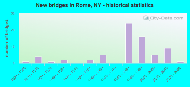
- New bridges - historical statistics
- 11900-1909
- 41910-1919
- 11920-1929
- 21930-1939
- 21950-1959
- 51960-1969
- 241980-1989
- 161990-1999
- 52000-2009
- 92010-2019
- 12020-2022
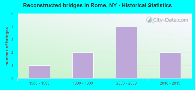
- Reconstructed bridges - Historical Statistics
- 11980-1989
- 21990-1999
- 42000-2009
- 22010-2019
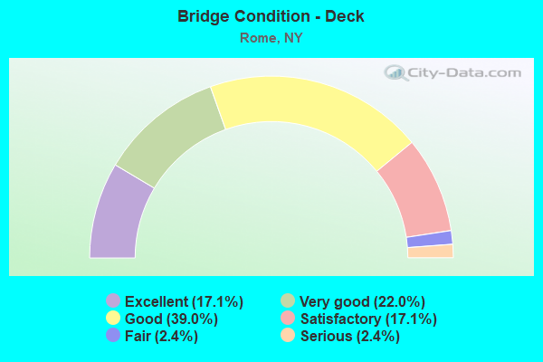
- Bridge Condition - Deck
- 17.1%Excellent
- 22.0%Very good
- 39.0%Good
- 17.1%Satisfactory
- 2.4%Fair
- 2.4%Serious
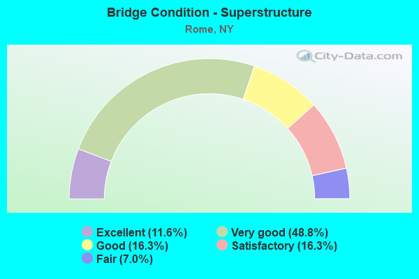
- Bridge Condition - Superstructure
- 11.6%Excellent
- 48.8%Very good
- 16.3%Good
- 16.3%Satisfactory
- 7.0%Fair
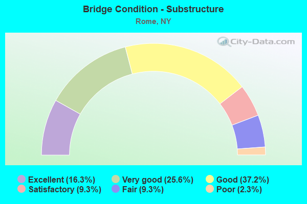
- Bridge Condition - Substructure
- 16.3%Excellent
- 25.6%Very good
- 37.2%Good
- 9.3%Satisfactory
- 9.3%Fair
- 2.3%Poor
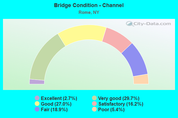
- Bridge Condition - Channel
- 2.7%Excellent
- 29.7%Very good
- 27.0%Good
- 16.2%Satisfactory
- 18.9%Fair
- 5.4%Poor
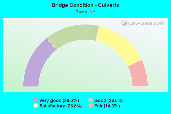
- Bridge Condition - Culverts
- 28.6%Very good
- 28.6%Good
- 28.6%Satisfactory
- 14.3%Fair
Find on map >> Show street view
Structure Number: 226328, Location: IN ROME (Lat: 43.217811, Lng: -75.465158), Route carried "on" structure: City street , Year Built: 1930, Status: Open, Structure Length: 0.85m (2.79ft), Average Daily Traffic: 768 (year 2017), Truck Traffic: 3%, Average Future Daily Traffic: 1,075 (year 2037), Features Intersected: WOOD CREEK, Facility Carried by Structure: WEST COURT STREET
Minimum Vertical Clearance: 32.69m (107.25ft), Kilometerpoint: 1.223, Lanes on structure: 2, Owner: City or Municipal Highway Agency, Approaching Roadway Width: 9.4m (30.8ft), Material/Design: Steel continuous, Design/Construction: Stringer/Multi-beam, Number Of Spans In Main Unit: 2, Length of Maximum Span: 3.9m (12.8ft), Curb or Sidewalk Widths: Left: 1.4m (4.6ft), Right: 2.1m (6.9ft), Curb-To-Curb Width: 9.4m (30.8ft), Out-to-Out Width: 18.3m (60.0ft)
Condition: Deck: Satisfactory, Superstructure: Satisfactory, Substructure: Satisfactory, Channel: Fair, Operating Rating: 72.8 metric tons, Method Used To Determine Operating Rating: Field evaluation and documented engineering judgment, Inventory Rating: 32.7 metric tons, Method Used To Determine Inventory Rating: Field evaluation and documented engineering judgment, Structural Evaluation: Equal to present minimum criteria, Deck Geometry: Equal to present minimum criteria, Waterway Adequacy: Meets minimum limits, Approach Roadway Alignment: Equal to present desirable criteria, Length Of Structure Improvement: 0.85m (2.79ft), Designated Inspection Frequency: Every 24 months, Inspection Date: June 2020, Bridge Improvement Cost: $353,000, Roadway Improvement Cost: $207,000, Total Project Cost: $559,000 ( Estimate for 2021), Wearing Surface/Protective System: Wearing Surface: Bituminous
Find on map >> Show street view
Structure Number: 226329, Location: ROME (Lat: 43.227506, Lng: -75.461500), Route carried "on" structure: City street , Year Built: 2003, Status: Open, Structure Length: 1.25m (4.10ft), Average Daily Traffic: 480 (year 2017), Truck Traffic: 3%, Average Future Daily Traffic: 672 (year 2037), Design Load: HS 25 or greater, Features Intersected: WOOD CREEK, Facility Carried by Structure: UNION STREET
Minimum Vertical Clearance: 30+ m (98+ ft), Kilometerpoint: 0.467, Lanes on structure: 2, Owner: City or Municipal Highway Agency, Approaching Roadway Width: 7.9m (25.9ft), Skew: 4 degrees, Material/Design: Concrete, Design/Construction: Frame, Number Of Spans In Main Unit: 1, Length of Maximum Span: 10.4m (34.1ft), Curb or Sidewalk Widths: Left: 3.1m (10.2ft), Right: 3.1m (10.2ft), Curb-To-Curb Width: 8.4m (27.6ft), Out-to-Out Width: 15.6m (51.2ft)
Condition: Deck: Very good, Superstructure: Very good, Substructure: Very good, Channel: Good, Operating Rating: 79.9 metric tons, Method Used To Determine Operating Rating: Field evaluation and documented engineering judgment, Inventory Rating: 40.8 metric tons, Method Used To Determine Inventory Rating: Field evaluation and documented engineering judgment, Structural Evaluation: Equal to present desirable criteria, Deck Geometry: Somewhat better than minimum adequacy, Waterway Adequacy: Meets minimum limits, Approach Roadway Alignment: Better than present minimum criteria, Length Of Structure Improvement: 1.24m (4.07ft), Designated Inspection Frequency: Every 24 months, Inspection Date: April 2021, Bridge Improvement Cost: $485,000, Roadway Improvement Cost: $284,000, Total Project Cost: $770,000 ( Estimate for 2021), Wearing Surface/Protective System: Wearing Surface: Bituminous, Membrane: Other
Find on map >> Show street view
Structure Number: 226911, Location: 0.5 MI N OF ROUTE 49 (Lat: 43.211775, Lng: -75.436606), Route carried "on" structure: City street , Year Built: 1966, Status: Open, Structure Length: 0.88m (2.89ft), Average Daily Traffic: 1,996 (year 2016), Truck Traffic: 5%, Average Future Daily Traffic: 2,794 (year 2036), Features Intersected: REVERE FEEDER FLOW, Facility Carried by Structure: CULVERTON STREET
Minimum Vertical Clearance: 30+ m (98+ ft), Kilometerpoint: 0.257, Lanes on structure: 2, Owner: City or Municipal Highway Agency, Approaching Roadway Width: 8.5m (27.9ft), Material/Design: Steel, Design/Construction: Culvert, Number Of Spans In Main Unit: 2, Length of Maximum Span: 3.6m (11.8ft), Curb or Sidewalk Widths: Left: 1.5m (4.9ft), Right: 0.0m
Condition: Channel: Satisfactory, Culverts: Good, Operating Rating: 75.1 metric tons, Method Used To Determine Operating Rating: Field evaluation and documented engineering judgment, Inventory Rating: 32.7 metric tons, Method Used To Determine Inventory Rating: Field evaluation and documented engineering judgment, Structural Evaluation: Better than present minimum criteria, Waterway Adequacy: Somewhat better than minimum adequacy, Approach Roadway Alignment: Equal to present desirable criteria, Length Of Structure Improvement: 0.88m (2.89ft), Designated Inspection Frequency: Every 24 months, Inspection Date: October 2020, Bridge Improvement Cost: $147,000, Roadway Improvement Cost: $86,000, Total Project Cost: $233,000 ( Estimate for 2021)
Find on map >> Show street view
Structure Number: 331094, Location: 1 MILE SOUTH OF ROME (Lat: 43.180803, Lng: -75.462322), Route carried "on" structure: County highway , Year Built: 1961, Year Reconstructed: 2007, Status: Open, Structure Length: 1.98m (6.50ft), Average Daily Traffic: 497 (year 2016), Truck Traffic: 4%, Average Future Daily Traffic: 696 (year 2036), Design Load: HS 20, Features Intersected: WHEELER CREEK, Facility Carried by Structure: CR44 LAWRENCE STRE
Minimum Vertical Clearance: 30+ m (98+ ft), Kilometerpoint: 1.754, Lanes on structure: 2, Owner: County Highway Agency, Approaching Roadway Width: 7.3m (24.0ft), Skew: 5 degrees, Material/Design: Steel, Design/Construction: Stringer/Multi-beam, Number Of Spans In Main Unit: 1, Length of Maximum Span: 17.4m (57.1ft), Curb-To-Curb Width: 7.8m (25.6ft), Out-to-Out Width: 8.8m (28.9ft)
Condition: Deck: Very good, Superstructure: Very good, Substructure: Good, Channel: Fair, Operating Rating: 76.2 metric tons, Method Used To Determine Operating Rating: Load Factor (LF), Inventory Rating: 45.4 metric tons, Method Used To Determine Inventory Rating: Load Factor (LF), Structural Evaluation: Better than present minimum criteria, Deck Geometry: Meets minimum limits, Waterway Adequacy: Somewhat better than minimum adequacy, Approach Roadway Alignment: Better than present minimum criteria, Length Of Structure Improvement: 1.98m (6.50ft), Designated Inspection Frequency: Every 24 months, Inspection Date: May 2021, Bridge Improvement Cost: $555,000, Roadway Improvement Cost: $325,000, Total Project Cost: $880,000 ( Estimate for 2021), Deck Structure Type: Concrete Cast-file-Place, Wearing Surface/Protective System: Wearing Surface: Integral Concrete, Deck Protection: Epoxy Coated Reinforcing
Find on map >> Show street view
Structure Number: 331095, Location: IN ROME (Lat: 43.240444, Lng: -75.435958), Route carried "on" structure: County highway , Year Built: 1986, Status: Open, Structure Length: 7.35m (24.11ft), Average Daily Traffic: 1,915 (year 2018), Truck Traffic: 5%, Average Future Daily Traffic: 2,369 (year 2040), Design Load: HS 20, Features Intersected: MOHAWK RIVER, Facility Carried by Structure: CR47 WRIGHT SETTLE
Minimum Vertical Clearance: 30+ m (98+ ft), Kilometerpoint: 0.000, Lanes on structure: 2, Owner: County Highway Agency, Approaching Roadway Width: 10.4m (34.1ft), Material/Design: Steel, Design/Construction: Stringer/Multi-beam, Number Of Spans In Main Unit: 2, Length of Maximum Span: 45.1m (148.0ft), Curb-To-Curb Width: 10.4m (34.1ft), Out-to-Out Width: 11.0m (36.1ft)
Condition: Deck: Good, Superstructure: Good, Substructure: Good, Channel: Satisfactory, Operating Rating: 73.5 metric tons, Method Used To Determine Operating Rating: Load Factor (LF), Inventory Rating: 43.5 metric tons, Method Used To Determine Inventory Rating: Load Factor (LF), Structural Evaluation: Better than present minimum criteria, Deck Geometry: Equal to present minimum criteria, Waterway Adequacy: Somewhat better than minimum adequacy, Approach Roadway Alignment: Equal to present desirable criteria, Length Of Structure Improvement: 7.34m (24.08ft), Designated Inspection Frequency: Every 24 months, Inspection Date: August 2020, Bridge Improvement Cost: $1,343,000, Roadway Improvement Cost: $786,000, Total Project Cost: $2,129,000 ( Estimate for 2021), Deck Structure Type: Concrete Cast-file-Place, Wearing Surface/Protective System: Wearing Surface: Integral Concrete, Deck Protection: Epoxy Coated Reinforcing
Find on map >> Show street view
Structure Number: 331096, Location: IN ROME (Lat: 43.249589, Lng: -75.414533), Route carried "on" structure: County highway , Year Built: 2010, Status: Open, Structure Length: 1.16m (3.81ft), Average Daily Traffic: 1,201 (year 2018), Truck Traffic: 4%, Average Future Daily Traffic: 1,485 (year 2040), Design Load: HS 25 or greater, Features Intersected: SIX MILE CREEK, Facility Carried by Structure: CR47 BUTTERNUT ROA
Minimum Vertical Clearance: 30+ m (98+ ft), Kilometerpoint: 2.623, Lanes on structure: 2, Owner: County Highway Agency, Approaching Roadway Width: 8.5m (27.9ft), Material/Design: Concrete, Design/Construction: Frame, Number Of Spans In Main Unit: 1, Length of Maximum Span: 11.0m (36.1ft), Curb-To-Curb Width: 7.5m (24.6ft), Out-to-Out Width: 8.4m (27.6ft)
Condition: Deck: Excellent, Superstructure: Very good, Substructure: Excellent, Channel: Poor, Operating Rating: 80.4 metric tons, Method Used To Determine Operating Rating: Field evaluation and documented engineering judgment, Inventory Rating: 40.8 metric tons, Method Used To Determine Inventory Rating: Field evaluation and documented engineering judgment, Structural Evaluation: Equal to present desirable criteria, Deck Geometry: Meets minimum limits, Waterway Adequacy: Meets minimum limits, Approach Roadway Alignment: Better than present minimum criteria, Length Of Structure Improvement: 1.15m (3.77ft), Designated Inspection Frequency: Every 24 months, Inspection Date: October 2020, Bridge Improvement Cost: $310,000, Roadway Improvement Cost: $181,000, Total Project Cost: $491,000 ( Estimate for 2021), Wearing Surface/Protective System: Wearing Surface: Bituminous
Find on map >> Show street view
Structure Number: 331097, Location: 3 MILES SW OF ROME (Lat: 43.177389, Lng: -75.530856), Route carried "on" structure: County highway , Year Built: 1984, Status: Open, Structure Length: 0.70m (2.30ft), Average Daily Traffic: 575 (year 2017), Truck Traffic: 4%, Average Future Daily Traffic: 805 (year 2037), Features Intersected: MUD CREEK, Facility Carried by Structure: CR50 GREENWAY NEW
Minimum Vertical Clearance: 30+ m (98+ ft), Kilometerpoint: 4.940, Lanes on structure: 2, Owner: County Highway Agency, Approaching Roadway Width: 8.2m (26.9ft), Skew: 1 degrees, Material/Design: Steel, Design/Construction: Culvert, Number Of Spans In Main Unit: 2, Length of Maximum Span: 3.0m (9.8ft)
Condition: Channel: Fair, Culverts: Satisfactory, Operating Rating: 74.8 metric tons, Method Used To Determine Operating Rating: Field evaluation and documented engineering judgment, Inventory Rating: 32.7 metric tons, Method Used To Determine Inventory Rating: Field evaluation and documented engineering judgment, Structural Evaluation: Equal to present minimum criteria, Waterway Adequacy: Meets minimum limits, Approach Roadway Alignment: Better than present minimum criteria, Length Of Structure Improvement: 0.70m (2.30ft), Designated Inspection Frequency: Every 24 months, Inspection Date: August 2020, Bridge Improvement Cost: $112,000, Roadway Improvement Cost: $66,000, Total Project Cost: $178,000 ( Estimate for 2021), Wearing Surface/Protective System: Wearing Surface: Bituminous
Find on map >> Show street view
Structure Number: 4018871, Location: 0.6 MI S JCT RTS 46 & 26 (Lat: 43.202064, Lng: -75.454558), Route carried "on" structure: State highway 26, Year Built: 1997, Status: Open, Structure Length: 17.37m (56.99ft), Average Daily Traffic: 7,520 (year 2017), Truck Traffic: 6%, Average Future Daily Traffic: 7,555 (year 2040), Design Load: HS 25 or greater, Features Intersected: E.WHITESBORO ST, BARGE C
Minimum Vertical Clearance: 30+ m (98+ ft), Kilometerpoint: 35.575, Lanes on structure: 2, Lanes under structure: 2, Base Highway Network: Yes, Owner: State Highway Agency, Approaching Roadway Width: 11.0m (36.1ft), Skew: 1 degrees, Navigation Control: Yes ( Vertical Clearance: 11.5m (37.7ft), Horizontal Clearance: 13.7m (44.9ft)), Material/Design: Steel continuous, Design/Construction: Stringer/Multi-beam, Number Of Spans In Main Unit: 4, Length of Maximum Span: 50.9m (167.0ft), Curb-To-Curb Width: 10.9m (35.8ft), Out-to-Out Width: 11.8m (38.7ft)
Condition: Deck: Good, Superstructure: Very good, Substructure: Good, Channel: Very good, Operating Rating: 78.0 metric tons, Method Used To Determine Operating Rating: Load Factor (LF), Inventory Rating: 47.2 metric tons, Method Used To Determine Inventory Rating: Load Factor (LF), Structural Evaluation: Better than present minimum criteria, Deck Geometry: Somewhat better than minimum adequacy, Underclear: Superior to present desirable criteria, Waterway Adequacy: Equal to present desirable criteria, Approach Roadway Alignment: Equal to present desirable criteria, Length Of Structure Improvement: 17.37m (56.99ft), Designated Inspection Frequency: Every 24 months, Inspection Date: May 2021, Bridge Improvement Cost: $3,211,000, Roadway Improvement Cost: $1,881,000, Total Project Cost: $5,092,000 ( Estimate for 2021), Deck Structure Type: Concrete Cast-file-Place, Wearing Surface/Protective System: Wearing Surface: Integral Concrete, Deck Protection: Epoxy Coated Reinforcing
Find on map >> Show street view
Structure Number: 4018872, Location: 0.6 MI S JCT RTE 46+26 (Lat: 43.201067, Lng: -75.453914), Route carried "on" structure: State highway 26, Year Built: 1996, Status: Open, Structure Length: 18.04m (59.19ft), Average Daily Traffic: 7,520 (year 2017), Truck Traffic: 6%, Average Future Daily Traffic: 7,555 (year 2040), Design Load: HS 25 or greater, Features Intersected: E. WHITESBORO ST, BARGE
Minimum Vertical Clearance: 30.18m (99.02ft), Kilometerpoint: 35.575, Lanes on structure: 2, Lanes under structure: 2, Base Highway Network: Yes, Owner: State Highway Agency, Approaching Roadway Width: 11.0m (36.1ft), Skew: 1 degrees, Navigation Control: Yes ( Vertical Clearance: 11.5m (37.7ft), Horizontal Clearance: 13.7m (44.9ft)), Material/Design: Steel continuous, Design/Construction: Stringer/Multi-beam, Number Of Spans In Main Unit: 4, Length of Maximum Span: 50.9m (167.0ft), Curb-To-Curb Width: 10.8m (35.4ft), Out-to-Out Width: 11.8m (38.7ft)
Condition: Deck: Good, Superstructure: Very good, Substructure: Good, Channel: Good, Operating Rating: 79.8 metric tons, Method Used To Determine Operating Rating: Load Factor (LF), Inventory Rating: 48.1 metric tons, Method Used To Determine Inventory Rating: Load Factor (LF), Structural Evaluation: Better than present minimum criteria, Deck Geometry: Somewhat better than minimum adequacy, Underclear: Superior to present desirable criteria, Waterway Adequacy: Equal to present minimum criteria, Approach Roadway Alignment: Equal to present desirable criteria, Length Of Structure Improvement: 18.04m (59.19ft), Designated Inspection Frequency: Every 24 months, Inspection Date: June 2020, Bridge Improvement Cost: $3,336,000, Roadway Improvement Cost: $1,954,000, Total Project Cost: $5,290,000 ( Estimate for 2021), Deck Structure Type: Concrete Cast-file-Place, Wearing Surface/Protective System: Wearing Surface: Integral Concrete, Deck Protection: Epoxy Coated Reinforcing
Find on map >> Show street view
Structure Number: 420645, Location: S JAMES ST /CANAL IN ROME (Lat: 43.201583, Lng: -75.467342), Route carried "on" structure: City street , Year Built: 1991, Status: Open, Structure Length: 8.69m (28.51ft), Average Daily Traffic: 4,501 (year 2020), Truck Traffic: 4%, Average Future Daily Traffic: 5,569 (year 2040), Design Load: HS 20, Features Intersected: ERIE BARGE CANAL, Facility Carried by Structure: SOUTH JAMES ST
Minimum Vertical Clearance: 5.13m (16.83ft), Kilometerpoint: 1.818, Lanes on structure: 2, Owner: City or Municipal Highway Agency, Approaching Roadway Width: 9.8m (32.2ft), Navigation Control: Yes ( Vertical Clearance: 6.7m (22.0ft), Horizontal Clearance: 31.6m (103.7ft)), Material/Design: Steel, Design/Construction: Truss - Thru, Number Of Spans In Main Unit: 1, Length of Maximum Span: 85.3m (279.9ft), Curb or Sidewalk Widths: Left: 0.0m, Right: 1.5m (4.9ft), Curb-To-Curb Width: 9.8m (32.2ft), Out-to-Out Width: 12.6m (41.3ft)
Condition: Deck: Good, Superstructure: Good, Substructure: Good, Channel: Very good, Operating Rating: 59.0 metric tons, Method Used To Determine Operating Rating: Load Factor (LF), Inventory Rating: 40.8 metric tons, Method Used To Determine Inventory Rating: Load Factor (LF), Structural Evaluation: Better than present minimum criteria, Deck Geometry: Meets minimum limits, Waterway Adequacy: Equal to present minimum criteria, Approach Roadway Alignment: Equal to present desirable criteria, Length Of Structure Improvement: 8.68m (28.48ft), Designated Inspection Frequency: Every 24 months, Critical Feature Inspection Frequency: Every 24 months, Inspection Date: August 2021, Critical Feature Inspection Date: August 2021, Bridge Improvement Cost: $7,889,000, Roadway Improvement Cost: $4,620,000, Total Project Cost: $12,509,000 ( Estimate for 2021), Deck Structure Type: Concrete Cast-file-Place, Wearing Surface/Protective System: Wearing Surface: Integral Concrete, Deck Protection: Epoxy Coated Reinforcing
Find on map >> Show street view
Structure Number: 442604, Location: OVER BARGE CANAL S ROME (Lat: 43.200783, Lng: -75.448308), Route carried "on" structure: City street , Year Built: 1992, Status: Open, Structure Length: 7.32m (24.02ft), Average Daily Traffic: 4,465 (year 2020), Truck Traffic: 5%, Average Future Daily Traffic: 5,524 (year 2040), Design Load: HS 20, Features Intersected: ERIE BARGE CANAL, Facility Carried by Structure: MILL ST
Minimum Vertical Clearance: 5.11m (16.77ft), Kilometerpoint: 0.161, Lanes on structure: 2, Owner: State Highway Agency, Approaching Roadway Width: 9.1m (29.9ft), Navigation Control: Yes ( Vertical Clearance: 6.4m (21.0ft), Horizontal Clearance: 42.6m (139.8ft)), Material/Design: Steel, Design/Construction: Truss - Thru, Number Of Spans In Main Unit: 1, Length of Maximum Span: 71.6m (234.9ft), Curb or Sidewalk Widths: Left: 1.5m (4.9ft), Right: 0.0m, Curb-To-Curb Width: 9.1m (29.9ft), Out-to-Out Width: 11.4m (37.4ft)
Condition: Deck: Good, Superstructure: Very good, Substructure: Good, Channel: Excellent, Operating Rating: 69.9 metric tons, Method Used To Determine Operating Rating: Load Factor (LF), Inventory Rating: 35.4 metric tons, Method Used To Determine Inventory Rating: Load Factor (LF), Structural Evaluation: Better than present minimum criteria, Deck Geometry: Meets minimum limits, Waterway Adequacy: Equal to present minimum criteria, Approach Roadway Alignment: Equal to present desirable criteria, Length Of Structure Improvement: 7.31m (23.98ft), Designated Inspection Frequency: Every 24 months, Critical Feature Inspection Frequency: Every 24 months, Inspection Date: October 2020, Critical Feature Inspection Date: October 2020, Bridge Improvement Cost: $6,582,000, Roadway Improvement Cost: $3,854,000, Total Project Cost: $10,436,000 ( Estimate for 2021), Deck Structure Type: Concrete Cast-file-Place, Wearing Surface/Protective System: Wearing Surface: Integral Concrete, Deck Protection: Epoxy Coated Reinforcing
Find on map >> Show street view
Structure Number: 4426331, Location: 1.3 MI E JCT 69 & BARGE C (Lat: 43.201481, Lng: -75.428108), Route carried "on" structure: State highway 49, Year Built: 1980, Status: Open, Structure Length: 34.53m (113.29ft), Average Daily Traffic: 7,136 (year 2015), Truck Traffic: 10%, Average Future Daily Traffic: 8,905 (year 2040), Design Load: HS 20, Features Intersected: Relief, MA&N Railroad, N
Minimum Vertical Clearance: 30+ m (98+ ft), Kilometerpoint: 42.252, Lanes on structure: 3, Lanes under structure: 1, Base Highway Network: Yes, Owner: State Highway Agency, Approaching Roadway Width: 14.0m (45.9ft), Navigation Control: Yes ( Vertical Clearance: 11.2m (36.7ft), Horizontal Clearance: 31.6m (103.7ft)), Material/Design: Steel continuous, Design/Construction: Stringer/Multi-beam, Number Of Spans In Main Unit: 7, Length of Maximum Span: 60.3m (197.8ft), Curb-To-Curb Width: 14.1m (46.3ft), Out-to-Out Width: 15.1m (49.5ft)
Condition: Deck: Good, Superstructure: Very good, Substructure: Good, Channel: Very good, Operating Rating: 53.5 metric tons, Method Used To Determine Operating Rating: Load Factor (LF), Inventory Rating: 31.8 metric tons, Method Used To Determine Inventory Rating: Load Factor (LF), Structural Evaluation: Better than present minimum criteria, Deck Geometry: Meets minimum limits, Underclear: Somewhat better than minimum adequacy, Waterway Adequacy: Equal to present minimum criteria, Approach Roadway Alignment: Equal to present desirable criteria, Length Of Structure Improvement: 34.53m (113.29ft), Designated Inspection Frequency: Every 24 months, Underwater Inspection Frequency: Every 60 months, Inspection Date: December 2020, Underwater Inspection Date: August 2017, Bridge Improvement Cost: $7,861,000, Roadway Improvement Cost: $4,604,000, Total Project Cost: $12,465,000 ( Estimate for 2021), Deck Structure Type: Concrete Cast-file-Place, Wearing Surface/Protective System: Wearing Surface: Monolithic Concrete, Deck Protection: Epoxy Coated Reinforcing
Find on map >> Show street view
Structure Number: 4426332, Location: 1.3 MI E JCT SH69 & CANAL (Lat: 43.201453, Lng: -75.427756), Route carried "on" structure: State highway 49, Year Built: 1980, Status: Open, Structure Length: 33.77m (110.79ft), Average Daily Traffic: 7,136 (year 2015), Truck Traffic: 10%, Average Future Daily Traffic: 8,905 (year 2040), Design Load: HS 20, Features Intersected: Relief, MA&N Railroad, N
Minimum Vertical Clearance: 30+ m (98+ ft), Kilometerpoint: 42.252, Lanes on structure: 3, Lanes under structure: 1, Base Highway Network: Yes, Owner: State Highway Agency, Approaching Roadway Width: 14.0m (45.9ft), Navigation Control: Yes ( Vertical Clearance: 11.2m (36.7ft), Horizontal Clearance: 31.6m (103.7ft)), Material/Design: Steel continuous, Design/Construction: Stringer/Multi-beam, Number Of Spans In Main Unit: 7, Length of Maximum Span: 57.9m (190.0ft), Curb-To-Curb Width: 14.2m (46.6ft), Out-to-Out Width: 15.2m (49.9ft)
Condition: Deck: Good, Superstructure: Very good, Substructure: Good, Channel: Very good, Operating Rating: 77.1 metric tons, Method Used To Determine Operating Rating: Load Factor (LF), Inventory Rating: 46.3 metric tons, Method Used To Determine Inventory Rating: Load Factor (LF), Structural Evaluation: Better than present minimum criteria, Deck Geometry: Meets minimum limits, Underclear: Better than present minimum criteria, Waterway Adequacy: Equal to present minimum criteria, Approach Roadway Alignment: Equal to present desirable criteria, Length Of Structure Improvement: 33.77m (110.79ft), Designated Inspection Frequency: Every 24 months, Underwater Inspection Frequency: Every 60 months, Inspection Date: December 2020, Underwater Inspection Date: August 2017, Bridge Improvement Cost: $7,697,000, Roadway Improvement Cost: $4,508,000, Total Project Cost: $12,205,000 ( Estimate for 2021), Deck Structure Type: Concrete Cast-file-Place, Wearing Surface/Protective System: Wearing Surface: Latex Concrete, Deck Protection: Epoxy Coated Reinforcing
Find on map >> Show street view
Structure Number: 101884, Location: 0.8 MI W JCT RTS 233 & 69 (Lat: 43.192008, Lng: -75.452275), Route carried "under" structure: Ramp State highway 365, Year Built: 2013, Structure Length: 0. m, Average Daily Traffic: 2,000 (year 1981), Features Intersected: RTE 365, Facility Carried by Structure: RTE 69
Minimum Vertical Clearance: 5.28m (17.32ft), Kilometerpoint: 18.005, Lanes on structure: 1, Lanes under structure: 2, Material/Design: Steel, Design/Construction: Stringer/Multi-beam, Length of Maximum Span: 15.7m (51.5ft)
Find on map >> Show street view
Structure Number: 101885, Location: .6 MI W JCT SH233 & SH 69 (Lat: 43.192264, Lng: -75.448950), Route carried "under" structure: Ramp State highway 365, Year Built: 2013, Structure Length: 0. m, Average Daily Traffic: 2,000 (year 1981), Features Intersected: RTE 365, Facility Carried by Structure: RTE 26
Minimum Vertical Clearance: 5.13m (16.83ft), Kilometerpoint: 18.005, Lanes on structure: 1, Lanes under structure: 2, Material/Design: Steel, Design/Construction: Stringer/Multi-beam, Length of Maximum Span: 14.9m (48.9ft)
Find on map >> Show street view
Structure Number: 1018861, Location: 0.4 MI S JCT RTS 49 & 26 (Lat: 43.199908, Lng: -75.453542), Route carried "under" structure: City street , Year Built: 1997, Structure Length: 0. m, Average Daily Traffic: 501 (year 2019), Truck Traffic: 7%, Features Intersected: MARTIN STREET, CSX TRANS, Facility Carried by Structure: RTE 26
Minimum Vertical Clearance: 9.14m (29.99ft), Kilometerpoint: 0.499, Lanes on structure: 2, Lanes under structure: 2, Material/Design: Steel continuous, Design/Construction: Stringer/Multi-beam, Length of Maximum Span: 45.7m (149.9ft)
Find on map >> Show street view
Structure Number: 1018862, Location: 0.4 MI S JCT RTE 49+26 (Lat: 43.199903, Lng: -75.453356), Route carried "under" structure: City street , Year Built: 1996, Structure Length: 0. m, Average Daily Traffic: 501 (year 2019), Truck Traffic: 7%, Features Intersected: MARTIN STREET, CSX TRANS, Facility Carried by Structure: RTE 26
Minimum Vertical Clearance: 9.99m (32.78ft), Kilometerpoint: 0.274, Lanes on structure: 2, Lanes under structure: 2, Material/Design: Steel continuous, Design/Construction: Stringer/Multi-beam, Length of Maximum Span: 45.7m (149.9ft)
Find on map >> Show street view
Structure Number: 102574, Location: JCT RTS 46+26 (Lat: 43.209075, Lng: -75.457381), Route carried "under" structure: State highway 46, Year Built: 1960, Structure Length: 0. m, Average Daily Traffic: 17,259 (year 1995), Features Intersected: RTE 46, Facility Carried by Structure: RTE 26
Minimum Vertical Clearance: 4.60m (15.09ft), Kilometerpoint: 8.190, Lanes on structure: 2, Lanes under structure: 1, Material/Design: Concrete, Design/Construction: Frame, Length of Maximum Span: 10.9m (35.8ft)
Find on map >> Show street view
Structure Number: 102624, Location: JCT NY 365 & NY 49 (Lat: 43.203819, Lng: -75.410544), Route carried "under" structure: State highway 49, Year Built: 2005, Structure Length: 0. m, Average Daily Traffic: 14,871 (year 2000), Features Intersected: 49 49 26023010 WB, RTE
Minimum Vertical Clearance: 5.26m (17.26ft), Kilometerpoint: 12.035, Lanes on structure: 2, Lanes under structure: 4, Material/Design: Steel, Design/Construction: Stringer/Multi-beam, Length of Maximum Span: 49.2m (161.4ft)
Find on map >> Show street view
Structure Number: 1069641, Location: 0.6 MI W JCT RTS 49 & 365 (Lat: 43.204217, Lng: -75.423631), Route carried "under" structure: ServiceOther road , Year Built: 1980, Structure Length: 0. m, Average Daily Traffic: 100 (year 2021), Features Intersected: SERVICE (LADO) RO, Facility Carried by Structure: RTE 49
Minimum Vertical Clearance: 4.54m (14.90ft), Kilometerpoint: 0.000, Lanes on structure: 2, Lanes under structure: 4, Material/Design: Prestressed concrete, Design/Construction: Box Beam or Girders - Multiple, Length of Maximum Span: 32.0m (105.0ft)
Find on map >> Show street view
Structure Number: 1069642, Location: .6 MI W JCT SH 49 & SH365 (Lat: 43.204050, Lng: -75.423603), Route carried "under" structure: ServiceOther road , Year Built: 1980, Structure Length: 0. m, Average Daily Traffic: 100 (year 2021), Features Intersected: SERVICE (LADO) RO, Facility Carried by Structure: RTE 49
Minimum Vertical Clearance: 4.57m (14.99ft), Kilometerpoint: 0.000, Lanes on structure: 2, Lanes under structure: 4, Material/Design: Prestressed concrete, Design/Construction: Box Beam or Girders - Multiple, Length of Maximum Span: 32.0m (105.0ft)
Find on map >> Show street view
Structure Number: 106975, Location: SE CORNER OF ROME (Lat: 43.204869, Lng: -75.410908), Route carried "under" structure: State highway 365, Year Built: 1980, Structure Length: 0. m, Average Daily Traffic: 100 (year 2021), Features Intersected: RTE 365, Facility Carried by Structure: Alternate Other road 5 825
Minimum Vertical Clearance: 4.70m (15.42ft), Kilometerpoint: 0.000, Lanes on structure: 3, Lanes under structure: 2, Material/Design: Steel, Design/Construction: Stringer/Multi-beam, Length of Maximum Span: 21.6m (70.9ft)
Find on map >> Show street view
Structure Number: 106976, Location: CITY OF ROME NY (Lat: 43.204969, Lng: -75.411453), Route carried "under" structure: State highway 365, Year Built: 1980, Structure Length: 0. m, Average Daily Traffic: 100 (year 2021), Features Intersected: RTE 365, Facility Carried by Structure: RAMP FM NY 825 TO
Minimum Vertical Clearance: 4.67m (15.32ft), Kilometerpoint: 0.000, Lanes on structure: 1, Lanes under structure: 2, Material/Design: Steel, Design/Construction: Stringer/Multi-beam, Length of Maximum Span: 28.3m (92.8ft)
Find on map >> Show street view
Structure Number: 1070031, Location: JCT ROME ART & SH 233 (Lat: 43.194106, Lng: -75.437192), Route carried "under" structure: State highway 233, Year Built: 1980, Structure Length: 0. m, Average Daily Traffic: 11,333 (year 2012), Features Intersected: RTE 233, Facility Carried by Structure: RTE 49
Minimum Vertical Clearance: 4.95m (16.24ft), Kilometerpoint: 18.664, Lanes on structure: 3, Lanes under structure: 3, Material/Design: Steel, Design/Construction: Stringer/Multi-beam, Length of Maximum Span: 39.6m (129.9ft)
Find on map >> Show street view
Structure Number: 1070032, Location: JCT ROME ART & SH 233 (Lat: 43.193944, Lng: -75.437042), Route carried "under" structure: State highway 233, Year Built: 1980, Structure Length: 0. m, Average Daily Traffic: 11,333 (year 2012), Features Intersected: RTE 233, Facility Carried by Structure: RTE 49
Minimum Vertical Clearance: 4.70m (15.42ft), Kilometerpoint: 18.664, Lanes on structure: 2, Lanes under structure: 3, Material/Design: Steel, Design/Construction: Stringer/Multi-beam, Length of Maximum Span: 39.6m (129.9ft)
Find on map >> Show street view
Structure Number: 109419, Location: 08MI W JCT RTS 233+69 (Lat: 43.190633, Lng: -75.449625), Route carried "under" structure: Ramp State highway 26, Year Built: 2013, Structure Length: 0. m, Average Daily Traffic: 4,133 (year 2015), Truck Traffic: 8%, Features Intersected: RTE 26, Facility Carried by Structure: RTE 69
Minimum Vertical Clearance: 4.75m (15.58ft), Kilometerpoint: 34.143, Lanes on structure: 1, Lanes under structure: 1, Material/Design: Steel, Design/Construction: Stringer/Multi-beam, Length of Maximum Span: 14.0m (45.9ft)
Find on map >> Show street view
Structure Number: 4018871, Location: 0.6 MI S JCT RTS 46 & 26 (Lat: 43.202064, Lng: -75.454558), Route carried "under" structure: ServiceCity street , Year Built: 1997, Structure Length: 0. m, Average Daily Traffic: 100 (year 2021), Features Intersected: E.WHITESBORO ST, BARGE C, Facility Carried by Structure: RTE 26
Minimum Vertical Clearance: 5.41m (17.75ft), Kilometerpoint: 0.000, Lanes on structure: 2, Lanes under structure: 2, Material/Design: Steel continuous, Design/Construction: Stringer/Multi-beam, Length of Maximum Span: 50.9m (167.0ft)
Find on map >> Show street view
Structure Number: 4018872, Location: 0.6 MI S JCT RTE 46+26 (Lat: 43.201067, Lng: -75.453914), Route carried "under" structure: ServiceOther road , Year Built: 1996, Structure Length: 0. m, Average Daily Traffic: 300 (year 2021), Features Intersected: E. WHITESBORO ST, BARGE, Facility Carried by Structure: RTE 26
Minimum Vertical Clearance: 5.16m (16.93ft), Kilometerpoint: 0.000, Lanes on structure: 2, Lanes under structure: 2, Material/Design: Steel continuous, Design/Construction: Stringer/Multi-beam, Length of Maximum Span: 50.9m (167.0ft)
Find on map >> Show street view
Structure Number: 4426331, Location: 1.3 MI E JCT 69 & BARGE C (Lat: 43.201481, Lng: -75.428108), Route carried "under" structure: Ramp State highway , Year Built: 1980, Structure Length: 0. m, Average Daily Traffic: 1,547 (year 1988), Features Intersected: Relief, MA&N Railroad, N, Facility Carried by Structure: RTE 49
Minimum Vertical Clearance: 6.65m (21.82ft), Kilometerpoint: 0.000, Lanes on structure: 3, Lanes under structure: 1, Material/Design: Steel continuous, Design/Construction: Stringer/Multi-beam, Length of Maximum Span: 60.3m (197.8ft)
Find on map >> Show street view
Structure Number: 4426332, Location: 1.3 MI E JCT SH69 & CANAL (Lat: 43.201453, Lng: -75.427756), Route carried "under" structure: Ramp State highway , Year Built: 1980, Structure Length: 0. m, Average Daily Traffic: 1,547 (year 1988), Features Intersected: Relief, MA&N Railroad, N, Facility Carried by Structure: RTE 49
Minimum Vertical Clearance: 6.27m (20.57ft), Kilometerpoint: 0.000, Lanes on structure: 3, Lanes under structure: 1, Material/Design: Steel continuous, Design/Construction: Stringer/Multi-beam, Length of Maximum Span: 57.9m (190.0ft)
Find on map >> Show street view
Structure Number: 771508, Location: SO JAMES ST. IN S.W. ROME (Lat: 43.200269, Lng: -75.468722), Route carried "under" structure: City street , Year Built: 1912, Structure Length: 0. m, Average Daily Traffic: 4,380 (year 1982), Features Intersected: SOUTH JAMES ST, Facility Carried by Structure: CSX TRANSPRTATION
Minimum Vertical Clearance: 3.61m (11.84ft), Kilometerpoint: 0.000, Lanes under structure: 2, Material/Design: Concrete, Design/Construction: Arch - Deck, Length of Maximum Span: 10.9m (35.8ft)
Find on map >> Show street view
Structure Number: 771509, Location: LAWRENCE ST. IN S.W. ROME (Lat: 43.199992, Lng: -75.456558), Route carried "under" structure: City street , Year Built: 1912, Structure Length: 0. m, Average Daily Traffic: 1,040 (year 1981), Features Intersected: LAWRENCE STREET, Facility Carried by Structure: CSX TRANSPRTATION
Minimum Vertical Clearance: 3.28m (10.76ft), Kilometerpoint: 0.000, Lanes under structure: 2, Material/Design: Concrete, Design/Construction: Arch - Deck, Length of Maximum Span: 10.9m (35.8ft)
Find on map >> Show street view
Structure Number: 77151, Location: MILL ST. S.W. ROME (Lat: 43.199775, Lng: -75.448364), Route carried "under" structure: City street , Year Built: 1912, Structure Length: 0. m, Average Daily Traffic: 4,465 (year 2020), Truck Traffic: 5%, Features Intersected: MILL STREET (SB), Facility Carried by Structure: CSX TRANSPRTATION
Minimum Vertical Clearance: 4.09m (13.42ft), Kilometerpoint: 0.048, Lanes under structure: 3, Material/Design: Concrete, Design/Construction: Arch - Deck, Length of Maximum Span: 10.9m (35.8ft)