Bridge Statistics for Rye, New York (NY)
Condition, Traffic, Stress, Structural Evaluation, Project Costs
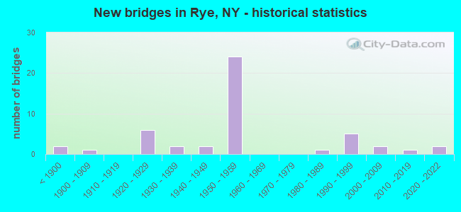
- New bridges - historical statistics
- 2Before 1900
- 11900-1909
- 61920-1929
- 21930-1939
- 21940-1949
- 241950-1959
- 11980-1989
- 51990-1999
- 22000-2009
- 12010-2019
- 22020-2022
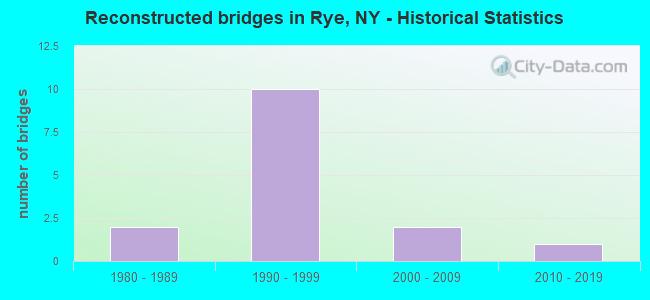
- Reconstructed bridges - Historical Statistics
- 21980-1989
- 101990-1999
- 22000-2009
- 12010-2019
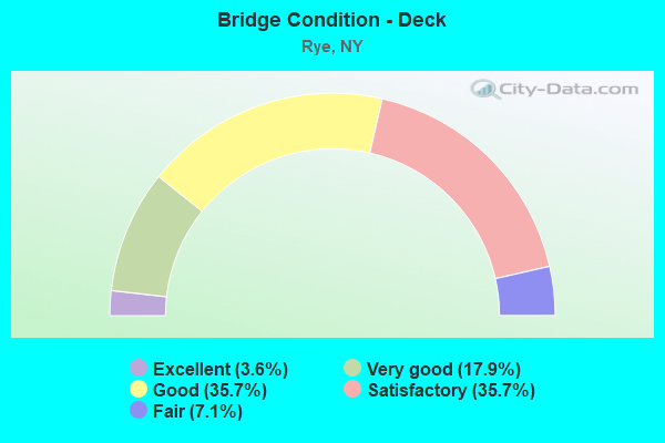
- Bridge Condition - Deck
- 3.6%Excellent
- 17.9%Very good
- 35.7%Good
- 35.7%Satisfactory
- 7.1%Fair
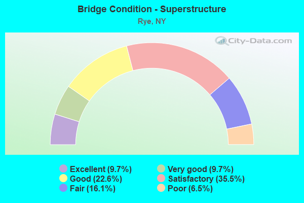
- Bridge Condition - Superstructure
- 9.7%Excellent
- 9.7%Very good
- 22.6%Good
- 35.5%Satisfactory
- 16.1%Fair
- 6.5%Poor
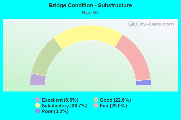
- Bridge Condition - Substructure
- 6.5%Excellent
- 22.6%Good
- 38.7%Satisfactory
- 29.0%Fair
- 3.2%Poor
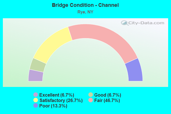
- Bridge Condition - Channel
- 6.7%Excellent
- 6.7%Good
- 26.7%Satisfactory
- 46.7%Fair
- 13.3%Poor
Find on map >> Show street view
Structure Number: 100009, Location: JCT US 1 & I287 (Lat: 40.991708, Lng: -73.677261), Route carried "on" structure: US 1, Year Built: 1959, Year Reconstructed: 1993, Status: Open, Structure Length: 8.32m (27.30ft), Average Daily Traffic: 20,841 (year 2020), Truck Traffic: 4%, Average Future Daily Traffic: 20,938 (year 2040), Design Load: HS 20+Mod, Features Intersected: 287I287I87011104 WB, RTE
Minimum Vertical Clearance: 30+ m (98+ ft), Kilometerpoint: 17.120, Lanes on structure: 4, Lanes under structure: 6, Base Highway Network: Yes, Owner: State Highway Agency, Approaching Roadway Width: 14.6m (47.9ft), Skew: 3 degrees, Material/Design: Steel, Design/Construction: Stringer/Multi-beam, Number Of Spans In Main Unit: 4, Length of Maximum Span: 22.5m (73.8ft), Curb or Sidewalk Widths: Left: 1.5m (4.9ft), Right: 1.5m (4.9ft), Curb-To-Curb Width: 14.6m (47.9ft), Out-to-Out Width: 18.3m (60.0ft)
Condition: Deck: Satisfactory, Superstructure: Satisfactory, Substructure: Fair, Operating Rating: 76.2 metric tons, Method Used To Determine Operating Rating: Load Factor (LF), Inventory Rating: 45.4 metric tons, Method Used To Determine Inventory Rating: Load Factor (LF), Structural Evaluation: Somewhat better than minimum adequacy, Deck Geometry: High priority of replacement, Underclear: High priority of corrective action, Approach Roadway Alignment: Equal to present desirable criteria, Length Of Structure Improvement: 8.32m (27.30ft), Designated Inspection Frequency: Every 24 months, Inspection Date: November 2021, Bridge Improvement Cost: $5,894,000, Roadway Improvement Cost: $3,452,000, Total Project Cost: $9,346,000 ( Estimate for 2021), Deck Structure Type: Concrete Cast-file-Place, Wearing Surface/Protective System: Wearing Surface: Bituminous, Membrane: Other
Find on map >> Show street view
Structure Number: 103732, Location: 06 MI NW JCT 120 & NETHRY (Lat: 40.993906, Lng: -73.686617), Route carried "on" structure: State highway 120, Year Built: 1994, Status: Open, Structure Length: 1.49m (4.89ft), Average Daily Traffic: 4,416 (year 2017), Truck Traffic: 3%, Average Future Daily Traffic: 5,364 (year 2040), Design Load: HS 20, Features Intersected: BLIND BROOK
Minimum Vertical Clearance: 30+ m (98+ ft), Kilometerpoint: 1.464, Lanes on structure: 2, Base Highway Network: Yes, Owner: State Highway Agency, Approaching Roadway Width: 9.1m (29.9ft), Skew: 1 degrees, Material/Design: Prestressed concrete, Design/Construction: Box Beam or Girders - Multiple, Number Of Spans In Main Unit: 1, Length of Maximum Span: 14.0m (45.9ft), Curb or Sidewalk Widths: Left: 1.5m (4.9ft), Right: 1.6m (5.2ft), Curb-To-Curb Width: 9.1m (29.9ft), Out-to-Out Width: 12.9m (42.3ft)
Condition: Deck: Very good, Superstructure: Good, Substructure: Good, Channel: Satisfactory, Operating Rating: 70.8 metric tons, Method Used To Determine Operating Rating: Load Factor (LF), Inventory Rating: 28.1 metric tons, Method Used To Determine Inventory Rating: Load Factor (LF), Structural Evaluation: Better than present minimum criteria, Deck Geometry: Meets minimum limits, Waterway Adequacy: Equal to present minimum criteria, Approach Roadway Alignment: Equal to present desirable criteria, Length Of Structure Improvement: 1.49m (4.89ft), Designated Inspection Frequency: Every 24 months, Inspection Date: November 2020, Bridge Improvement Cost: $553,000, Roadway Improvement Cost: $324,000, Total Project Cost: $876,000 ( Estimate for 2021), Wearing Surface/Protective System: Wearing Surface: Bituminous
Find on map >> Show street view
Structure Number: 1049859, Location: .2 MI E JCT I287 & US 1 (Lat: 40.989397, Lng: -73.674442), Route carried "on" structure: Interstate 287, Year Built: 1957, Year Reconstructed: 2009, Status: Open, Structure Length: 9.08m (29.79ft), Average Daily Traffic: 45,761 (year 2016), Truck Traffic: 15%, Average Future Daily Traffic: 77,491 (year 2040), Design Load: HS 20+Mod, Features Intersected: RAMPS J R & D, MNRR NH L
Minimum Vertical Clearance: 30+ m (98+ ft), Kilometerpoint: 22.767, Lanes on structure: 5, Lanes under structure: 3, Base Highway Network: Yes, Owner: State Highway Agency, Approaching Roadway Width: 32.0m (105.0ft), Skew: 20 degrees, Material/Design: Steel, Design/Construction: Stringer/Multi-beam, Number Of Spans In Main Unit: 4, Length of Maximum Span: 29.5m (96.8ft), Curb-To-Curb Width: 29.0m (95.1ft), Out-to-Out Width: 30.9m (101.4ft)
Condition: Deck: Satisfactory, Superstructure: Satisfactory, Substructure: Satisfactory, Operating Rating: 50.8 metric tons, Method Used To Determine Operating Rating: Load Factor (LF), Inventory Rating: 30.8 metric tons, Method Used To Determine Inventory Rating: Load Factor (LF), Structural Evaluation: Equal to present minimum criteria, Deck Geometry: Superior to present desirable criteria, Underclear: Better than present minimum criteria, Approach Roadway Alignment: Equal to present desirable criteria, Length Of Structure Improvement: 9.08m (29.79ft), Designated Inspection Frequency: Every 24 months, Inspection Date: December 2021, Bridge Improvement Cost: $10,430,000, Roadway Improvement Cost: $6,108,000, Total Project Cost: $16,538,000 ( Estimate for 2021), Deck Structure Type: Concrete Cast-file-Place, Wearing Surface/Protective System: Wearing Surface: Latex Concrete
Find on map >> Show street view
Structure Number: 1049879, Location: 0.2MI NW JCT I287&NE THRY (Lat: 40.988136, Lng: -73.672047), Route carried "on" structure: Ramp Interstate 287, Year Built: 1958, Year Reconstructed: 1990, Status: Open, Structure Length: 7.89m (25.89ft), Average Daily Traffic: 45,761 (year 2016), Truck Traffic: 15%, Average Future Daily Traffic: 77,491 (year 2040), Design Load: HS 20+Mod, Features Intersected: MIDLAND AVENUE
Minimum Vertical Clearance: 30+ m (98+ ft), Kilometerpoint: 23.025, Lanes on structure: 5, Lanes under structure: 2, Base Highway Network: Yes, Owner: State Highway Agency, Approaching Roadway Width: 29.9m (98.1ft), Skew: 20 degrees, Material/Design: Steel, Design/Construction: Stringer/Multi-beam, Number Of Spans In Main Unit: 3, Length of Maximum Span: 25.9m (85.0ft), Curb-To-Curb Width: 29.3m (96.1ft), Out-to-Out Width: 31.3m (102.7ft)
Condition: Deck: Satisfactory, Superstructure: Satisfactory, Substructure: Satisfactory, Operating Rating: 71.3 metric tons, Method Used To Determine Operating Rating: Load and Resistance Factor Rating (LRFR) rating reported by rating factor(RF) method using HL-93 loadings, Inventory Rating: 55.1 metric tons, Method Used To Determine Inventory Rating: Load and Resistance Factor Rating (LRFR) rating reported by rating factor(RF) method using HL-93 loadings, Structural Evaluation: Equal to present minimum criteria, Deck Geometry: Superior to present desirable criteria, Underclear: Better than present minimum criteria, Approach Roadway Alignment: Equal to present desirable criteria, Length Of Structure Improvement: 7.89m (25.89ft), Designated Inspection Frequency: Every 24 months, Inspection Date: September 2021, Bridge Improvement Cost: $9,390,000, Roadway Improvement Cost: $5,499,000, Total Project Cost: $14,889,000 ( Estimate for 2021), Deck Structure Type: Concrete Cast-file-Place, Wearing Surface/Protective System: Wearing Surface: Integral Concrete, Deck Protection: Epoxy Coated Reinforcing
Find on map >> Show street view
Structure Number: 200005, Location: JCT RTE 1&PLAYLAND PKWY (Lat: 40.971558, Lng: -73.693694), Route carried "on" structure: US 1, Year Built: 1941, Status: Open, Structure Length: 1.92m (6.30ft), Average Daily Traffic: 8,415 (year 2017), Truck Traffic: 3%, Average Future Daily Traffic: 8,454 (year 2040), Features Intersected: PLAYLAND PARKWAY
Minimum Vertical Clearance: 30+ m (98+ ft), Kilometerpoint: 14.433, Lanes on structure: 2, Lanes under structure: 4, Base Highway Network: Yes, Owner: City or Municipal Highway Agency, Approaching Roadway Width: 11.7m (38.4ft), Skew: 20 degrees, Material/Design: Concrete, Design/Construction: Frame, Number Of Spans In Main Unit: 1, Length of Maximum Span: 18.5m (60.7ft), Curb or Sidewalk Widths: Left: 0.0m, Right: 1.5m (4.9ft), Curb-To-Curb Width: 11.1m (36.4ft), Out-to-Out Width: 22.0m (72.2ft)
Condition: Deck: Satisfactory, Superstructure: Fair, Substructure: Fair, Operating Rating: 56.2 metric tons, Method Used To Determine Operating Rating: Field evaluation and documented engineering judgment, Inventory Rating: 20.3 metric tons, Method Used To Determine Inventory Rating: Field evaluation and documented engineering judgment, Structural Evaluation: Somewhat better than minimum adequacy, Deck Geometry: Meets minimum limits, Underclear: High priority of corrective action, Approach Roadway Alignment: Meets minimum limits, Length Of Structure Improvement: 1.92m (6.30ft), Designated Inspection Frequency: Every 24 months, Inspection Date: March 2021, Bridge Improvement Cost: $2,095,000, Roadway Improvement Cost: $1,227,000, Total Project Cost: $3,322,000 ( Estimate for 2021), Deck Structure Type: Concrete Cast-file-Place, Wearing Surface/Protective System: Wearing Surface: Bituminous
Find on map >> Show street view
Structure Number: 222525, Location: 1.6 MI SW OF PORT CHESTER (Lat: 40.986669, Lng: -73.685800), Route carried "on" structure: Business City street , Year Built: 1989, Status: Open, Structure Length: 0.94m (3.08ft), Average Daily Traffic: 3,028 (year 2021), Truck Traffic: 4%, Average Future Daily Traffic: 4,239 (year 0000), Design Load: HS 20+Mod, Features Intersected: BLIND BROOK, Facility Carried by Structure: HIGHLAND ROAD
Minimum Vertical Clearance: 30+ m (98+ ft), Kilometerpoint: 0.145, Lanes on structure: 2, Owner: City or Municipal Highway Agency, Approaching Roadway Width: 11.0m (36.1ft), Material/Design: Prestressed concrete, Design/Construction: Box Beam or Girders - Multiple, Number Of Spans In Main Unit: 1, Length of Maximum Span: 9.1m (29.9ft), Curb or Sidewalk Widths: Left: 1.8m (5.9ft), Right: 1.8m (5.9ft), Curb-To-Curb Width: 11.0m (36.1ft), Out-to-Out Width: 15.2m (49.9ft)
Condition: Deck: Satisfactory, Superstructure: Satisfactory, Substructure: Satisfactory, Channel: Satisfactory, Operating Rating: 52.8 metric tons, Method Used To Determine Operating Rating: Load and Resistance Factor Rating (LRFR) rating reported by rating factor(RF) method using HL-93 loadings, Inventory Rating: 39.2 metric tons, Method Used To Determine Inventory Rating: Load and Resistance Factor Rating (LRFR) rating reported by rating factor(RF) method using HL-93 loadings, Structural Evaluation: Equal to present minimum criteria, Deck Geometry: Somewhat better than minimum adequacy, Waterway Adequacy: Meets minimum limits, Approach Roadway Alignment: Equal to present desirable criteria, Length Of Structure Improvement: 0.94m (3.08ft), Designated Inspection Frequency: Every 24 months, Inspection Date: July 2021, Bridge Improvement Cost: $470,000, Roadway Improvement Cost: $276,000, Total Project Cost: $746,000 ( Estimate for 2021), Deck Structure Type: Concrete Cast-file-Place, Wearing Surface/Protective System: Wearing Surface: Integral Concrete, Deck Protection: Epoxy Coated Reinforcing
Find on map >> Show street view
Structure Number: 222526, Location: 2.9 MI NE MAMARONECK RYE (Lat: 40.982500, Lng: -73.685367), Route carried "on" structure: City street , Year Built: 1928, Status: Open, Structure Length: 1.01m (3.31ft), Average Daily Traffic: 2,904 (year 2016), Truck Traffic: 1%, Average Future Daily Traffic: 4,066 (year 2036), Features Intersected: BLIND BROOK, Facility Carried by Structure: LOCUST AVENUE
Minimum Vertical Clearance: 30+ m (98+ ft), Kilometerpoint: 1.335, Lanes on structure: 2, Owner: City or Municipal Highway Agency, Approaching Roadway Width: 9.8m (32.2ft), Material/Design: Concrete, Design/Construction: Tee Beam, Number Of Spans In Main Unit: 1, Length of Maximum Span: 8.8m (28.9ft), Curb or Sidewalk Widths: Left: 1.8m (5.9ft), Right: 1.8m (5.9ft), Curb-To-Curb Width: 9.8m (32.2ft), Out-to-Out Width: 14.9m (48.9ft)
Condition: Deck: Satisfactory, Superstructure: Poor, Substructure: Fair, Channel: Fair, Operating Rating: 37.3 metric tons, Method Used To Determine Operating Rating: Load and Resistance Factor Rating (LRFR) rating reported by rating factor(RF) method using HL-93 loadings, Inventory Rating: 28.5 metric tons, Method Used To Determine Inventory Rating: Load and Resistance Factor Rating (LRFR) rating reported by rating factor(RF) method using HL-93 loadings, Structural Evaluation: Meets minimum limits, Deck Geometry: Meets minimum limits, Waterway Adequacy: Meets minimum limits, Approach Roadway Alignment: Equal to present minimum criteria, Length Of Structure Improvement: 1.00m (3.28ft), Designated Inspection Frequency: Every 24 months, Inspection Date: March 2021, Bridge Improvement Cost: $759,000, Roadway Improvement Cost: $444,000, Total Project Cost: $1,203,000 ( Estimate for 2021), Deck Structure Type: Concrete Cast-file-Place, Wearing Surface/Protective System: Wearing Surface: Bituminous
Find on map >> Show street view
Structure Number: 222527, Location: AT CITY OF RYE (Lat: 40.979872, Lng: -73.684675), Route carried "on" structure: City street , Year Built: 1929, Status: Posted for load, Structure Length: 1.07m (3.51ft), Average Daily Traffic: 1,621 (year 2017), Truck Traffic: 4%, Average Future Daily Traffic: 2,269 (year 2037), Features Intersected: BLIND BROOK, Facility Carried by Structure: ORCHARD AVENUE
Minimum Vertical Clearance: 30+ m (98+ ft), Kilometerpoint: 0.032, Lanes on structure: 2, Owner: City or Municipal Highway Agency, Approaching Roadway Width: 9.1m (29.9ft), Skew: 2 degrees, Material/Design: Steel, Design/Construction: Stringer/Multi-beam, Number Of Spans In Main Unit: 1, Length of Maximum Span: 9.1m (29.9ft), Curb or Sidewalk Widths: Left: 2.4m (7.9ft), Right: 2.4m (7.9ft), Curb-To-Curb Width: 9.1m (29.9ft), Out-to-Out Width: 15.0m (49.2ft)
Condition: Deck: Satisfactory, Superstructure: Satisfactory, Substructure: Fair, Channel: Fair, Operating Rating: 12.7 metric tons, Method Used To Determine Operating Rating: Field evaluation and documented engineering judgment, Inventory Rating: 12.7 metric tons, Method Used To Determine Inventory Rating: Field evaluation and documented engineering judgment, Structural Evaluation: Meets minimum limits, Deck Geometry: Somewhat better than minimum adequacy, Waterway Adequacy: Meets minimum limits, Approach Roadway Alignment: Equal to present desirable criteria, Bridge Posting: Required (Relationship of Operating Rating to Maximum Legal Load: > 39.9% below), Length Of Structure Improvement: 1.06m (3.48ft), Designated Inspection Frequency: Every 12 months, Inspection Date: April 2021, Bridge Improvement Cost: $1,296,000, Roadway Improvement Cost: $759,000, Total Project Cost: $2,055,000 ( Estimate for 2021), Deck Structure Type: Concrete Cast-file-Place, Wearing Surface/Protective System: Wearing Surface: Bituminous
Find on map >> Show street view
Structure Number: 222528, Location: AT 2700 FT S JCT 95 &120 (Lat: 40.978717, Lng: -73.685278), Route carried "on" structure: City street , Year Built: 2013, Status: Open, Structure Length: 1.31m (4.30ft), Average Daily Traffic: 1,329 (year 2016), Truck Traffic: 2%, Average Future Daily Traffic: 1,644 (year 2040), Design Load: HS 25 or greater, Features Intersected: BLIND BROOK, Facility Carried by Structure: CENTRAL AVENUE
Minimum Vertical Clearance: 30+ m (98+ ft), Kilometerpoint: 1.078, Lanes on structure: 2, Owner: City or Municipal Highway Agency, Approaching Roadway Width: 7.3m (24.0ft), Material/Design: Prestressed concrete, Design/Construction: Box Beam or Girders - Multiple, Number Of Spans In Main Unit: 1, Length of Maximum Span: 12.8m (42.0ft), Curb or Sidewalk Widths: Left: 1.8m (5.9ft), Right: 1.8m (5.9ft), Curb-To-Curb Width: 7.3m (24.0ft), Out-to-Out Width: 11.9m (39.0ft)
Condition: Deck: Very good, Superstructure: Excellent, Substructure: Excellent, Channel: Excellent, Operating Rating: 34.0 metric tons, Method Used To Determine Operating Rating: Load and Resistance Factor Rating (LRFR) rating reported by rating factor(RF) method using HL-93 loadings, Inventory Rating: 26.2 metric tons, Method Used To Determine Inventory Rating: Load and Resistance Factor Rating (LRFR) rating reported by rating factor(RF) method using HL-93 loadings, Structural Evaluation: Equal to present minimum criteria, Deck Geometry: Meets minimum limits, Waterway Adequacy: Equal to present desirable criteria, Approach Roadway Alignment: Equal to present desirable criteria, Length Of Structure Improvement: 1.31m (4.30ft), Designated Inspection Frequency: Every 24 months, Inspection Date: July 2021, Bridge Improvement Cost: $620,000, Roadway Improvement Cost: $363,000, Total Project Cost: $983,000 ( Estimate for 2021), Wearing Surface/Protective System: Wearing Surface: Monolithic Concrete
Find on map >> Show street view
Structure Number: 222529, Location: 0.38 MI N PLAYLAND PKWY (Lat: 40.974850, Lng: -73.687558), Route carried "on" structure: US 1, Year Built: 1934, Status: Open, Structure Length: 1.34m (4.40ft), Average Daily Traffic: 4,663 (year 2018), Truck Traffic: 3%, Average Future Daily Traffic: 4,684 (year 2040), Features Intersected: BLIND BROOK
Minimum Vertical Clearance: 30+ m (98+ ft), Kilometerpoint: 15.060, Lanes on structure: 2, Base Highway Network: Yes, Owner: City or Municipal Highway Agency, Approaching Roadway Width: 11.3m (37.1ft), Skew: 20 degrees, Material/Design: Masonry, Design/Construction: Arch - Deck, Number Of Spans In Main Unit: 1, Length of Maximum Span: 10.9m (35.8ft), Curb or Sidewalk Widths: Left: 0.0m, Right: 1.5m (4.9ft), Curb-To-Curb Width: 11.3m (37.1ft), Out-to-Out Width: 19.8m (65.0ft)
Condition: Superstructure: Fair, Substructure: Satisfactory, Channel: Poor, Operating Rating: 60.1 metric tons, Method Used To Determine Operating Rating: Field evaluation and documented engineering judgment, Inventory Rating: 15.8 metric tons, Method Used To Determine Inventory Rating: Field evaluation and documented engineering judgment, Structural Evaluation: Meets minimum limits, Deck Geometry: Somewhat better than minimum adequacy, Waterway Adequacy: Meets minimum limits, Approach Roadway Alignment: Meets minimum limits, Length Of Structure Improvement: 1.34m (4.40ft), Designated Inspection Frequency: Every 24 months, Inspection Date: March 2021, Bridge Improvement Cost: $912,000, Roadway Improvement Cost: $534,000, Total Project Cost: $1,446,000 ( Estimate for 2021), Wearing Surface/Protective System: Wearing Surface: Bituminous
Find on map >> Show street view
Structure Number: 22253, Location: 2.0 MILES NE MAMARONECK (Lat: 40.962428, Lng: -73.689261), Route carried "on" structure: City street , Year Built: 1993, Status: Open, Structure Length: 2.93m (9.61ft), Average Daily Traffic: 4,443 (year 2017), Truck Traffic: 2%, Average Future Daily Traffic: 5,397 (year 2040), Design Load: HS 20, Features Intersected: BLIND BROOK, Facility Carried by Structure: OAKLAND BEACH AVE
Minimum Vertical Clearance: 30+ m (98+ ft), Kilometerpoint: 0.917, Lanes on structure: 2, Owner: County Highway Agency, Maintenance Responsibility: City or Municipal Highway Agency, Approaching Roadway Width: 8.5m (27.9ft), Skew: 1 degrees, Material/Design: Prestressed concrete, Design/Construction: Box Beam or Girders - Multiple, Number Of Spans In Main Unit: 3, Length of Maximum Span: 9.1m (29.9ft), Curb or Sidewalk Widths: Left: 1.7m (5.6ft), Right: 1.7m (5.6ft), Curb-To-Curb Width: 8.5m (27.9ft), Out-to-Out Width: 12.5m (41.0ft)
Condition: Deck: Satisfactory, Superstructure: Satisfactory, Substructure: Good, Channel: Satisfactory, Operating Rating: 30.5 metric tons, Method Used To Determine Operating Rating: Load and Resistance Factor Rating (LRFR) rating reported by rating factor(RF) method using HL-93 loadings, Inventory Rating: 23.7 metric tons, Method Used To Determine Inventory Rating: Load and Resistance Factor Rating (LRFR) rating reported by rating factor(RF) method using HL-93 loadings, Structural Evaluation: Equal to present minimum criteria, Deck Geometry: Meets minimum limits, Waterway Adequacy: Somewhat better than minimum adequacy, Approach Roadway Alignment: Equal to present desirable criteria, Length Of Structure Improvement: 2.92m (9.58ft), Designated Inspection Frequency: Every 24 months, Inspection Date: March 2021, Bridge Improvement Cost: $1,316,000, Roadway Improvement Cost: $771,000, Total Project Cost: $2,087,000 ( Estimate for 2021), Deck Structure Type: Concrete Cast-file-Place, Wearing Surface/Protective System: Wearing Surface: Integral Concrete, Deck Protection: Epoxy Coated Reinforcing
Find on map >> Show street view
Structure Number: 226528, Location: 2.1 MI SW OF PORT CHESTER (Lat: 40.975650, Lng: -73.687250), Route carried "on" structure: Other road , Year Built: 1870, Status: Posted for load, Structure Length: 0.98m (3.22ft), Average Daily Traffic: 118 (year 1997), Truck Traffic: 3%, Average Future Daily Traffic: 165 (year 2017), Features Intersected: BLIND BROOK, Facility Carried by Structure: NATURE PR PARK RD
Minimum Vertical Clearance: 30+ m (98+ ft), Kilometerpoint: 0.000, Lanes on structure: 1, Owner: City or Municipal Highway Agency, Approaching Roadway Width: 4.3m (14.1ft), Skew: 1 degrees, Material/Design: Masonry, Design/Construction: Arch - Deck, Number Of Spans In Main Unit: 1, Length of Maximum Span: 8.5m (27.9ft), Curb-To-Curb Width: 4.3m (14.1ft), Out-to-Out Width: 5.5m (18.0ft)
Condition: Superstructure: Fair, Substructure: Fair, Channel: Fair, Operating Rating: 4.5 metric tons, Method Used To Determine Operating Rating: Field evaluation and documented engineering judgment, Inventory Rating: 4.5 metric tons, Method Used To Determine Inventory Rating: Field evaluation and documented engineering judgment, Structural Evaluation: High priority of corrective action, Deck Geometry: High priority of replacement, Waterway Adequacy: Equal to present desirable criteria, Approach Roadway Alignment: Equal to present desirable criteria, Bridge Posting: Required (Relationship of Operating Rating to Maximum Legal Load: > 39.9% below), Length Of Structure Improvement: 0.97m (3.18ft), Designated Inspection Frequency: Every 12 months, Inspection Date: March 2021, Bridge Improvement Cost: $183,000, Roadway Improvement Cost: $107,000, Total Project Cost: $290,000 ( Estimate for 2021), Wearing Surface/Protective System: Wearing Surface: Bituminous
Find on map >> Show street view
Structure Number: 226568, Location: 1.5 MI NE MAMARONECK RYE (Lat: 40.969244, Lng: -73.705447), Route carried "on" structure: City street , Year Built: 1929, Year Reconstructed: 2002, Status: Open, Structure Length: 0.73m (2.40ft), Average Daily Traffic: 2,027 (year 2020), Truck Traffic: 4%, Average Future Daily Traffic: 2,462 (year 2040), Features Intersected: BEAVER SWAMP BRK, Facility Carried by Structure: OSBORN ROAD
Minimum Vertical Clearance: 30+ m (98+ ft), Kilometerpoint: 0.660, Lanes on structure: 2, Owner: City or Municipal Highway Agency, Approaching Roadway Width: 9.4m (30.8ft), Skew: 1 degrees, Material/Design: Concrete, Design/Construction: Slab, Number Of Spans In Main Unit: 1, Length of Maximum Span: 6.0m (19.7ft), Curb or Sidewalk Widths: Left: 2.1m (6.9ft), Right: 1.2m (3.9ft), Curb-To-Curb Width: 9.4m (30.8ft), Out-to-Out Width: 14.9m (48.9ft)
Condition: Deck: Fair, Superstructure: Satisfactory, Substructure: Satisfactory, Channel: Fair, Operating Rating: 51.4 metric tons, Method Used To Determine Operating Rating: Field evaluation and documented engineering judgment, Inventory Rating: 22.0 metric tons, Method Used To Determine Inventory Rating: Field evaluation and documented engineering judgment, Structural Evaluation: Somewhat better than minimum adequacy, Deck Geometry: Meets minimum limits, Waterway Adequacy: Meets minimum limits, Approach Roadway Alignment: Equal to present desirable criteria, Length Of Structure Improvement: 0.73m (2.40ft), Designated Inspection Frequency: Every 24 months, Inspection Date: March 2021, Bridge Improvement Cost: $558,000, Roadway Improvement Cost: $327,000, Total Project Cost: $885,000 ( Estimate for 2021), Wearing Surface/Protective System: Wearing Surface: Bituminous
Find on map >> Show street view
Structure Number: 334801, Location: 1.2 MI NE MAMARONECK/RYE (Lat: 40.964867, Lng: -73.708469), Route carried "on" structure: County highway , Year Built: 1927, Status: Open, Structure Length: 0.82m (2.69ft), Average Daily Traffic: 2,229 (year 2017), Truck Traffic: 1%, Average Future Daily Traffic: 2,707 (year 2040), Features Intersected: BEAVER SWAMP BRK, Facility Carried by Structure: COUNTY ROAD 36
Minimum Vertical Clearance: 30+ m (98+ ft), Kilometerpoint: 0.386, Lanes on structure: 2, Owner: County Highway Agency, Approaching Roadway Width: 9.8m (32.2ft), Material/Design: Concrete, Design/Construction: Slab, Number Of Spans In Main Unit: 1, Length of Maximum Span: 7.6m (24.9ft), Curb or Sidewalk Widths: Left: 2.1m (6.9ft), Right: 2.1m (6.9ft), Curb-To-Curb Width: 9.7m (31.8ft), Out-to-Out Width: 14.8m (48.6ft)
Condition: Deck: Good, Superstructure: Good, Substructure: Good, Channel: Fair, Operating Rating: 51.2 metric tons, Method Used To Determine Operating Rating: Field evaluation and documented engineering judgment, Inventory Rating: 23.6 metric tons, Method Used To Determine Inventory Rating: Field evaluation and documented engineering judgment, Structural Evaluation: Equal to present minimum criteria, Deck Geometry: Meets minimum limits, Waterway Adequacy: Meets minimum limits, Approach Roadway Alignment: Equal to present desirable criteria, Length Of Structure Improvement: 0.82m (2.69ft), Designated Inspection Frequency: Every 24 months, Inspection Date: April 2021, Bridge Improvement Cost: $419,000, Roadway Improvement Cost: $245,000, Total Project Cost: $665,000 ( Estimate for 2021), Wearing Surface/Protective System: Wearing Surface: Bituminous
Find on map >> Show street view
Structure Number: 334806, Location: 2.9 MI NE MAMARONECK RYE (Lat: 40.983400, Lng: -73.687106), Route carried "on" structure: County highway , Year Built: 1928, Status: Open, Structure Length: 0.91m (2.99ft), Average Daily Traffic: 6,685 (year 2018), Truck Traffic: 3%, Average Future Daily Traffic: 8,120 (year 2040), Features Intersected: BLIND BROOK, Facility Carried by Structure: THEODORE FREMD AV
Minimum Vertical Clearance: 30+ m (98+ ft), Kilometerpoint: 2.526, Lanes on structure: 4, Owner: County Highway Agency, Approaching Roadway Width: 12.8m (42.0ft), Skew: 4 degrees, Material/Design: Steel, Design/Construction: Stringer/Multi-beam, Number Of Spans In Main Unit: 1, Length of Maximum Span: 8.5m (27.9ft), Curb or Sidewalk Widths: Left: 1.8m (5.9ft), Right: 1.7m (5.6ft), Curb-To-Curb Width: 20.7m (67.9ft), Out-to-Out Width: 24.4m (80.1ft)
Condition: Deck: Good, Superstructure: Satisfactory, Substructure: Fair, Channel: Fair, Operating Rating: 64.4 metric tons, Method Used To Determine Operating Rating: Load Factor (LF), Inventory Rating: 38.1 metric tons, Method Used To Determine Inventory Rating: Load Factor (LF), Structural Evaluation: Somewhat better than minimum adequacy, Deck Geometry: Superior to present desirable criteria, Waterway Adequacy: Meets minimum limits, Approach Roadway Alignment: Equal to present minimum criteria, Length Of Structure Improvement: 0.91m (2.99ft), Designated Inspection Frequency: Every 24 months, Inspection Date: April 2021, Bridge Improvement Cost: $2,364,000, Roadway Improvement Cost: $1,384,000, Total Project Cost: $3,748,000 ( Estimate for 2021), Deck Structure Type: Concrete Cast-file-Place, Wearing Surface/Protective System: Wearing Surface: Bituminous
Find on map >> Show street view
Structure Number: 334823, Location: 2.1 MI NE MAMARONECK RYE (Lat: 40.972889, Lng: -73.694667), Route carried "on" structure: County highway , Year Built: 1954, Year Reconstructed: 2012, Status: Open, Structure Length: 2.04m (6.69ft), Average Daily Traffic: 7,768 (year 2018), Truck Traffic: 3%, Average Future Daily Traffic: 9,436 (year 2040), Features Intersected: PLAYLAND PARKWAY SB, PLA, Facility Carried by Structure: OLD POST ROAD
Minimum Vertical Clearance: 30+ m (98+ ft), Kilometerpoint: 2.333, Lanes on structure: 2, Lanes under structure: 4, Owner: County Highway Agency, Approaching Roadway Width: 9.1m (29.9ft), Material/Design: Steel, Design/Construction: Stringer/Multi-beam, Number Of Spans In Main Unit: 1, Length of Maximum Span: 18.8m (61.7ft), Curb or Sidewalk Widths: Left: 1.5m (4.9ft), Right: 0.6m (2.0ft), Curb-To-Curb Width: 8.5m (27.9ft), Out-to-Out Width: 11.6m (38.1ft)
Condition: Deck: Satisfactory, Superstructure: Satisfactory, Substructure: Satisfactory, Operating Rating: 63.8 metric tons, Method Used To Determine Operating Rating: Load and Resistance Factor Rating (LRFR) rating reported by rating factor(RF) method using HL-93 loadings, Inventory Rating: 49.2 metric tons, Method Used To Determine Inventory Rating: Load and Resistance Factor Rating (LRFR) rating reported by rating factor(RF) method using HL-93 loadings, Structural Evaluation: Equal to present minimum criteria, Deck Geometry: High priority of replacement, Underclear: High priority of corrective action, Approach Roadway Alignment: Equal to present desirable criteria, Length Of Structure Improvement: 2.04m (6.69ft), Designated Inspection Frequency: Every 24 months, Inspection Date: April 2021, Bridge Improvement Cost: $1,684,000, Roadway Improvement Cost: $986,000, Total Project Cost: $2,671,000 ( Estimate for 2021), Deck Structure Type: Concrete Cast-file-Place, Wearing Surface/Protective System: Wearing Surface: Bituminous
Find on map >> Show street view
Structure Number: 3349, Location: 2.1 MI NE MAMARONECK RYE (Lat: 40.968697, Lng: -73.689406), Route carried "on" structure: County highway , Year Built: 1954, Year Reconstructed: 2004, Status: Open, Structure Length: 1.77m (5.81ft), Average Daily Traffic: 6,355 (year 2017), Truck Traffic: 5%, Average Future Daily Traffic: 7,720 (year 2040), Features Intersected: BLIND BROOK, Facility Carried by Structure: PLAYLAND PARKWAY
Minimum Vertical Clearance: 30+ m (98+ ft), Kilometerpoint: 0.998, Lanes on structure: 4, Owner: County Highway Agency, Approaching Roadway Width: 12.2m (40.0ft), Material/Design: Prestressed concrete, Design/Construction: Box Beam or Girders - Multiple, Number Of Spans In Main Unit: 2, Length of Maximum Span: 8.5m (27.9ft), Curb or Sidewalk Widths: Left: 0.0m, Right: 2.1m (6.9ft), Curb-To-Curb Width: 15.4m (50.5ft), Out-to-Out Width: 18.3m (60.0ft)
Condition: Deck: Good, Superstructure: Good, Substructure: Satisfactory, Channel: Satisfactory, Operating Rating: 67.9 metric tons, Method Used To Determine Operating Rating: Field evaluation and documented engineering judgment, Inventory Rating: 29.4 metric tons, Method Used To Determine Inventory Rating: Field evaluation and documented engineering judgment, Structural Evaluation: Equal to present minimum criteria, Deck Geometry: Meets minimum limits, Waterway Adequacy: Meets minimum limits, Approach Roadway Alignment: Equal to present desirable criteria, Length Of Structure Improvement: 1.76m (5.77ft), Designated Inspection Frequency: Every 24 months, Inspection Date: March 2021, Bridge Improvement Cost: $938,000, Roadway Improvement Cost: $550,000, Total Project Cost: $1,488,000 ( Estimate for 2021), Wearing Surface/Protective System: Wearing Surface: Bituminous
Find on map >> Show street view
Structure Number: 335851, Location: 2.9 MI NE MAMARONECK RYE (Lat: 40.967386, Lng: -73.671447), Route carried "on" structure: Other road , Year Built: 1927, Year Reconstructed: 1997, Status: Open, Structure Length: 0.73m (2.40ft), Average Daily Traffic: 504 (year 1997), Truck Traffic: 3%, Average Future Daily Traffic: 706 (year 2017), Design Load: HS 25 or greater, Features Intersected: PLAYLAND LAKE, Facility Carried by Structure: MANURSING ISL RD
Minimum Vertical Clearance: 30+ m (98+ ft), Kilometerpoint: 0.000, Lanes on structure: 2, Owner: County Highway Agency, Approaching Roadway Width: 9.1m (29.9ft), Material/Design: Prestressed concrete, Design/Construction: Box Beam or Girders - Multiple, Number Of Spans In Main Unit: 1, Length of Maximum Span: 6.7m (22.0ft), Curb or Sidewalk Widths: Left: 4.6m (15.1ft), Right: 4.6m (15.1ft), Curb-To-Curb Width: 9.1m (29.9ft), Out-to-Out Width: 19.4m (63.6ft)
Condition: Deck: Good, Superstructure: Good, Substructure: Satisfactory, Channel: Good, Operating Rating: 25.9 metric tons, Method Used To Determine Operating Rating: Load and Resistance Factor Rating (LRFR) rating reported by rating factor(RF) method using HL-93 loadings, Inventory Rating: 20.1 metric tons, Method Used To Determine Inventory Rating: Load and Resistance Factor Rating (LRFR) rating reported by rating factor(RF) method using HL-93 loadings, Structural Evaluation: Somewhat better than minimum adequacy, Deck Geometry: Equal to present minimum criteria, Waterway Adequacy: Equal to present minimum criteria, Approach Roadway Alignment: Equal to present desirable criteria, Length Of Structure Improvement: 0.73m (2.40ft), Designated Inspection Frequency: Every 24 months, Inspection Date: June 2021, Bridge Improvement Cost: $1,170,000, Roadway Improvement Cost: $685,000, Total Project Cost: $1,855,000 ( Estimate for 2021), Wearing Surface/Protective System: Wearing Surface: Bituminous, Membrane: Other
Find on map >> Show street view
Structure Number: 3364859, Location: 2.1 MI NE MAMARONECK RYE (Lat: 40.976222, Lng: -73.698225), Route carried "on" structure: County highway , Year Built: 1956, Year Reconstructed: 1996, Status: Open, Structure Length: 4.79m (15.72ft), Average Daily Traffic: 6,992 (year 2018), Truck Traffic: 4%, Average Future Daily Traffic: 7,024 (year 2040), Design Load: HS 20, Features Intersected: THEO FRMO AV-CR54, MNRR, Facility Carried by Structure: PLAYLAND PARKWAY
Minimum Vertical Clearance: 30+ m (98+ ft), Kilometerpoint: 2.124, Lanes on structure: 4, Lanes under structure: 3, Owner: State Toll Authority, Approaching Roadway Width: 19.8m (65.0ft), Skew: 20 degrees, Material/Design: Steel, Design/Construction: Stringer/Multi-beam, Number Of Spans In Main Unit: 2, Length of Maximum Span: 23.1m (75.8ft), Curb-To-Curb Width: 19.1m (62.7ft), Out-to-Out Width: 20.6m (67.6ft)
Condition: Deck: Good, Superstructure: Very good, Substructure: Satisfactory, Operating Rating: 61.2 metric tons, Method Used To Determine Operating Rating: Load and Resistance Factor Rating (LRFR) rating reported by rating factor(RF) method using HL-93 loadings, Inventory Rating: 47.3 metric tons, Method Used To Determine Inventory Rating: Load and Resistance Factor Rating (LRFR) rating reported by rating factor(RF) method using HL-93 loadings, Structural Evaluation: Equal to present minimum criteria, Deck Geometry: Equal to present minimum criteria, Underclear: Equal to present minimum criteria, Approach Roadway Alignment: Equal to present desirable criteria, Length Of Structure Improvement: 4.78m (15.68ft), Designated Inspection Frequency: Every 24 months, Inspection Date: December 2020, Bridge Improvement Cost: $5,411,000, Roadway Improvement Cost: $3,169,000, Total Project Cost: $8,579,000 ( Estimate for 2021), Deck Structure Type: Concrete Cast-file-Place, Wearing Surface/Protective System: Wearing Surface: Bituminous, Membrane: Other, Deck Protection: Galvanized Reinforcing
Find on map >> Show street view
Structure Number: 500008, Location: JCT RTE 1&I95 AT RYE (Lat: 40.987333, Lng: -73.680269), Route carried "on" structure: US 1, Year Built: 1958, Year Reconstructed: 1991, Status: Open, Structure Length: 4.42m (14.50ft), Average Daily Traffic: 10,542 (year 2020), Truck Traffic: 6%, Average Future Daily Traffic: 10,591 (year 2040), Design Load: HS 20+Mod, Features Intersected: 95IX South bound, RTE I9
Minimum Vertical Clearance: 30+ m (98+ ft), Kilometerpoint: 16.605, Lanes on structure: 2, Lanes under structure: 8, Base Highway Network: Yes, Owner: State Toll Authority, Approaching Roadway Width: 14.3m (46.9ft), Skew: 22 degrees, Material/Design: Steel, Design/Construction: Stringer/Multi-beam, Number Of Spans In Main Unit: 2, Length of Maximum Span: 21.3m (69.9ft), Curb or Sidewalk Widths: Left: 1.5m (4.9ft), Right: 0.0m, Curb-To-Curb Width: 14.6m (47.9ft), Out-to-Out Width: 16.9m (55.4ft)
Condition: Deck: Good, Superstructure: Satisfactory, Substructure: Poor, Operating Rating: 63.5 metric tons, Method Used To Determine Operating Rating: Load Factor (LF), Inventory Rating: 36.3 metric tons, Method Used To Determine Inventory Rating: Load Factor (LF), Structural Evaluation: Meets minimum limits, Deck Geometry: Superior to present desirable criteria, Underclear: High priority of corrective action, Approach Roadway Alignment: Equal to present desirable criteria, Length Of Structure Improvement: 4.41m (14.47ft), Designated Inspection Frequency: Every 24 months, Inspection Date: June 2020, Bridge Improvement Cost: $4,016,000, Roadway Improvement Cost: $2,352,000, Total Project Cost: $6,368,000 ( Estimate for 2021), Deck Structure Type: Concrete Cast-file-Place, Wearing Surface/Protective System: Wearing Surface: Integral Concrete, Deck Protection: Epoxy Coated Reinforcing
Find on map >> Show street view
Structure Number: 5037319, Location: 0.8 MI W JCT RTS I95+287 (Lat: 40.986125, Lng: -73.684225), Route carried "on" structure: Interstate 95, Year Built: 1957, Year Reconstructed: 1995, Status: Open, Structure Length: 13.56m (44.49ft), Average Daily Traffic: 91,678 (year 2018), Truck Traffic: 14%, Average Future Daily Traffic: 155,247 (year 2040), Design Load: HS 20+Mod, Features Intersected: STATION PARKING, 120 PUR
Minimum Vertical Clearance: 30+ m (98+ ft), Kilometerpoint: 15.929, Lanes on structure: 7, Lanes under structure: 5, Base Highway Network: Yes, Toll: On Interstate toll segment, Owner: State Toll Authority, Approaching Roadway Width: 33.5m (109.9ft), Skew: 20 degrees, Material/Design: Steel, Design/Construction: Stringer/Multi-beam, Number Of Spans In Main Unit: 8, Length of Maximum Span: 23.2m (76.1ft), Curb-To-Curb Width: 33.7m (110.6ft), Out-to-Out Width: 35.7m (117.1ft)
Condition: Deck: Good, Superstructure: Good, Substructure: Good, Operating Rating: 50.2 metric tons, Method Used To Determine Operating Rating: Load and Resistance Factor Rating (LRFR) rating reported by rating factor(RF) method using HL-93 loadings, Inventory Rating: 38.6 metric tons, Method Used To Determine Inventory Rating: Load and Resistance Factor Rating (LRFR) rating reported by rating factor(RF) method using HL-93 loadings, Structural Evaluation: Better than present minimum criteria, Deck Geometry: Superior to present desirable criteria, Underclear: Meets minimum limits, Approach Roadway Alignment: Equal to present desirable criteria, Length Of Structure Improvement: 13.56m (44.49ft), Designated Inspection Frequency: Every 24 months, Inspection Date: July 2021, Bridge Improvement Cost: $18,559,000, Roadway Improvement Cost: $10,868,000, Total Project Cost: $29,427,000 ( Estimate for 2021), Deck Structure Type: Concrete Cast-file-Place, Wearing Surface/Protective System: Wearing Surface: Bituminous, Deck Protection: Epoxy Coated Reinforcing
Find on map >> Show street view
Structure Number: 534824, Location: .9 MI E JCT I95 & SH 127 (Lat: 40.978186, Lng: -73.696683), Route carried "on" structure: County highway , Year Built: 1996, Status: Open, Structure Length: 7.92m (25.98ft), Average Daily Traffic: 4,375 (year 2020), Truck Traffic: 4%, Average Future Daily Traffic: 5,314 (year 2040), Design Load: HS 25 or greater, Features Intersected: RTE I95, MNRR NH LINE, Facility Carried by Structure: COUNTY ROAD 73
Minimum Vertical Clearance: 30+ m (98+ ft), Kilometerpoint: 1.480, Lanes on structure: 2, Lanes under structure: 8, Owner: State Toll Authority, Approaching Roadway Width: 10.1m (33.1ft), Skew: 1 degrees, Material/Design: Steel continuous, Design/Construction: Stringer/Multi-beam, Number Of Spans In Main Unit: 3, Length of Maximum Span: 30.2m (99.1ft), Curb or Sidewalk Widths: Left: 0.0m, Right: 1.5m (4.9ft), Curb-To-Curb Width: 10.1m (33.1ft), Out-to-Out Width: 12.3m (40.4ft)
Condition: Deck: Very good, Superstructure: Excellent, Substructure: Good, Operating Rating: 51.7 metric tons, Method Used To Determine Operating Rating: Load Factor (LF), Inventory Rating: 30.8 metric tons, Method Used To Determine Inventory Rating: Load Factor (LF), Structural Evaluation: Better than present minimum criteria, Deck Geometry: Meets minimum limits, Underclear: High priority of corrective action, Approach Roadway Alignment: Equal to present desirable criteria, Length Of Structure Improvement: 7.92m (25.98ft), Designated Inspection Frequency: Every 24 months, Inspection Date: Febuary 2020, Bridge Improvement Cost: $4,556,000, Roadway Improvement Cost: $2,668,000, Total Project Cost: $7,224,000 ( Estimate for 2021), Deck Structure Type: Concrete Cast-file-Place, Wearing Surface/Protective System: Wearing Surface: Integral Concrete, Deck Protection: Epoxy Coated Reinforcing
Find on map >> Show street view
Structure Number: 5514749, Location: 0.5 MI E JCT RTS I95<127 (Lat: 40.974847, Lng: -73.703642), Route carried "on" structure: Interstate 95, Year Built: 1956, Status: Open, Structure Length: 1.25m (4.10ft), Average Daily Traffic: 83,384 (year 2019), Truck Traffic: 15%, Average Future Daily Traffic: 141,202 (year 2040), Design Load: HS 20+Mod, Features Intersected: BEAVER SWAMP BROOK
Minimum Vertical Clearance: 30+ m (98+ ft), Kilometerpoint: 13.902, Lanes on structure: 7, Base Highway Network: Yes, Toll: On Interstate toll segment, Owner: State Toll Authority, Approaching Roadway Width: 32.3m (106.0ft), Skew: 20 degrees, Material/Design: Concrete continuous, Design/Construction: Culvert, Number Of Spans In Main Unit: 2, Length of Maximum Span: 6.1m (20.0ft), Curb-To-Curb Width: 32.9m (107.9ft), Out-to-Out Width: 39.9m (130.9ft)
Condition: Channel: Poor, Culverts: Satisfactory, Operating Rating: 76.9 metric tons, Method Used To Determine Operating Rating: Field evaluation and documented engineering judgment, Inventory Rating: 32.7 metric tons, Method Used To Determine Inventory Rating: Field evaluation and documented engineering judgment, Structural Evaluation: Equal to present minimum criteria, Deck Geometry: Better than present minimum criteria, Waterway Adequacy: Meets minimum limits, Approach Roadway Alignment: Equal to present desirable criteria, Length Of Structure Improvement: 1.24m (4.07ft), Designated Inspection Frequency: Every 24 months, Inspection Date: May 2021, Bridge Improvement Cost: $2,914,000, Roadway Improvement Cost: $1,706,000, Total Project Cost: $4,620,000 ( Estimate for 2021)
Find on map >> Show street view
Structure Number: 5514759, Location: .8 MI E JCT I95 & SH 127 (Lat: 40.976917, Lng: -73.698981), Route carried "on" structure: Ramp Other road , Year Built: 1956, Year Reconstructed: 1997, Status: Open, Structure Length: 3.51m (11.52ft), Average Daily Traffic: 2,534 (year 2018), Truck Traffic: 4%, Average Future Daily Traffic: 4,291 (year 2040), Design Load: HS 20+Mod, Features Intersected: 95IX Southbound, RTE I95, Facility Carried by Structure: PLAYLAND PARKWAY
Minimum Vertical Clearance: 30+ m (98+ ft), Kilometerpoint: 0.064, Lanes on structure: 2, Lanes under structure: 7, Owner: State Toll Authority, Approaching Roadway Width: 13.4m (44.0ft), Skew: 20 degrees, Material/Design: Steel, Design/Construction: Stringer/Multi-beam, Number Of Spans In Main Unit: 2, Length of Maximum Span: 18.3m (60.0ft), Curb-To-Curb Width: 14.3m (46.9ft), Out-to-Out Width: 15.1m (49.5ft)
Condition: Deck: Good, Superstructure: Good, Substructure: Fair, Operating Rating: 67.1 metric tons, Method Used To Determine Operating Rating: Load Factor (LF), Inventory Rating: 40.8 metric tons, Method Used To Determine Inventory Rating: Load Factor (LF), Structural Evaluation: Somewhat better than minimum adequacy, Deck Geometry: Superior to present desirable criteria, Underclear: High priority of corrective action, Approach Roadway Alignment: Equal to present desirable criteria, Length Of Structure Improvement: 3.50m (11.48ft), Designated Inspection Frequency: Every 24 months, Inspection Date: June 2021, Bridge Improvement Cost: $3,566,000, Roadway Improvement Cost: $2,088,000, Total Project Cost: $5,654,000 ( Estimate for 2021), Deck Structure Type: Concrete Cast-file-Place, Wearing Surface/Protective System: Wearing Surface: Bituminous, Membrane: Other, Deck Protection: Galvanized Reinforcing
Find on map >> Show street view
Structure Number: 551476, Location: 0.7 MI SW JCT RTS I95 + 1 (Lat: 40.981111, Lng: -73.692147), Route carried "on" structure: City street , Year Built: 1956, Year Reconstructed: 1997, Status: Open, Structure Length: 3.57m (11.71ft), Average Daily Traffic: 745 (year 2018), Truck Traffic: 1%, Average Future Daily Traffic: 921 (year 2040), Design Load: HS 20+Mod, Features Intersected: 95IX SB, RTE I95, Facility Carried by Structure: CENTRAL AVENUE
Minimum Vertical Clearance: 30+ m (98+ ft), Kilometerpoint: 0.434, Lanes on structure: 2, Lanes under structure: 6, Owner: State Toll Authority, Approaching Roadway Width: 9.1m (29.9ft), Skew: 1 degrees, Material/Design: Steel, Design/Construction: Stringer/Multi-beam, Number Of Spans In Main Unit: 2, Length of Maximum Span: 17.1m (56.1ft), Curb or Sidewalk Widths: Left: 0.8m (2.6ft), Right: 0.8m (2.6ft), Curb-To-Curb Width: 9.1m (29.9ft), Out-to-Out Width: 11.3m (37.1ft)
Condition: Deck: Fair, Superstructure: Satisfactory, Substructure: Satisfactory, Operating Rating: 76.2 metric tons, Method Used To Determine Operating Rating: Load Factor (LF), Inventory Rating: 45.4 metric tons, Method Used To Determine Inventory Rating: Load Factor (LF), Structural Evaluation: Equal to present minimum criteria, Deck Geometry: Equal to present minimum criteria, Underclear: High priority of corrective action, Approach Roadway Alignment: Equal to present desirable criteria, Length Of Structure Improvement: 3.56m (11.68ft), Designated Inspection Frequency: Every 24 months, Inspection Date: June 2021, Bridge Improvement Cost: $2,264,000, Roadway Improvement Cost: $1,326,000, Total Project Cost: $3,590,000 ( Estimate for 2021), Deck Structure Type: Concrete Cast-file-Place, Wearing Surface/Protective System: Wearing Surface: Bituminous, Membrane: Other
Find on map >> Show street view
Structure Number: 5514779, Location: 0.5 MI SW JCT I-95 & US 1 (Lat: 40.983078, Lng: -73.689111), Route carried "on" structure: Interstate 95, Year Built: 1956, Year Reconstructed: 1995, Status: Open, Structure Length: 1.80m (5.91ft), Average Daily Traffic: 91,678 (year 2018), Truck Traffic: 14%, Average Future Daily Traffic: 155,247 (year 2040), Design Load: HS 20+Mod, Features Intersected: LOCUST AVENUE
Minimum Vertical Clearance: 30+ m (98+ ft), Kilometerpoint: 15.430, Lanes on structure: 6, Lanes under structure: 2, Base Highway Network: Yes, Toll: On Interstate toll segment, Owner: State Toll Authority, Approaching Roadway Width: 30.2m (99.1ft), Skew: 22 degrees, Material/Design: Steel, Design/Construction: Stringer/Multi-beam, Number Of Spans In Main Unit: 1, Length of Maximum Span: 16.8m (55.1ft), Curb-To-Curb Width: 30.1m (98.8ft), Out-to-Out Width: 32.1m (105.3ft)
Condition: Deck: Good, Superstructure: Good, Substructure: Satisfactory, Operating Rating: 88.9 metric tons, Method Used To Determine Operating Rating: Load Factor (LF), Inventory Rating: 53.5 metric tons, Method Used To Determine Inventory Rating: Load Factor (LF), Structural Evaluation: Equal to present minimum criteria, Deck Geometry: Superior to present desirable criteria, Underclear: High priority of corrective action, Approach Roadway Alignment: Equal to present desirable criteria, Length Of Structure Improvement: 1.79m (5.87ft), Designated Inspection Frequency: Every 24 months, Inspection Date: April 2021, Bridge Improvement Cost: $5,211,000, Roadway Improvement Cost: $3,051,000, Total Project Cost: $8,262,000 ( Estimate for 2021), Deck Structure Type: Concrete Cast-file-Place, Wearing Surface/Protective System: Wearing Surface: Epoxy Overlay, Deck Protection: Epoxy Coated Reinforcing
Find on map >> Show street view
Structure Number: 5514789, Location: 0.4 MI SW JCT 95IX & US 1 (Lat: 40.984833, Lng: -73.686664), Route carried "on" structure: Interstate 95, Year Built: 1955, Status: Open, Structure Length: 0.91m (2.99ft), Average Daily Traffic: 91,678 (year 2018), Truck Traffic: 14%, Average Future Daily Traffic: 155,247 (year 2040), Design Load: HS 20+Mod, Features Intersected: BLIND BROOK
Minimum Vertical Clearance: 30+ m (98+ ft), Kilometerpoint: 15.704, Lanes on structure: 6, Base Highway Network: Yes, Toll: On Interstate toll segment, Owner: State Toll Authority, Approaching Roadway Width: 28.3m (92.8ft), Skew: 20 degrees, Material/Design: Concrete, Design/Construction: Arch - Deck, Number Of Spans In Main Unit: 1, Length of Maximum Span: 7.9m (25.9ft), Curb-To-Curb Width: 31.4m (103.0ft), Out-to-Out Width: 32.6m (107.0ft)
Condition: Superstructure: Fair, Substructure: Satisfactory, Channel: Fair, Operating Rating: 77.7 metric tons, Method Used To Determine Operating Rating: Field evaluation and documented engineering judgment, Inventory Rating: 29.4 metric tons, Method Used To Determine Inventory Rating: Field evaluation and documented engineering judgment, Structural Evaluation: Somewhat better than minimum adequacy, Deck Geometry: Superior to present desirable criteria, Waterway Adequacy: Meets minimum limits, Approach Roadway Alignment: Equal to present desirable criteria, Length Of Structure Improvement: 0.91m (2.99ft), Designated Inspection Frequency: Every 24 months, Inspection Date: March 2021, Bridge Improvement Cost: $1,024,000, Roadway Improvement Cost: $599,000, Total Project Cost: $1,623,000 ( Estimate for 2021)
Find on map >> Show street view
Structure Number: 5514799, Location: 0.3 MI W JCT I95 & I287 (Lat: 40.987864, Lng: -73.676419), Route carried "on" structure: Interstate 95, Year Built: 1956, Year Reconstructed: 1995, Status: Open, Structure Length: 11.95m (39.21ft), Average Daily Traffic: 59,963 (year 2018), Truck Traffic: 14%, Average Future Daily Traffic: 101,541 (year 2040), Design Load: HS 20+Mod, Features Intersected: RAMP D OF 95IX, MNRR NH
Minimum Vertical Clearance: 30+ m (98+ ft), Kilometerpoint: 16.605, Lanes on structure: 6, Lanes under structure: 2, Base Highway Network: Yes, Toll: On Interstate toll segment, Owner: State Toll Authority, Approaching Roadway Width: 30.2m (99.1ft), Skew: 22 degrees, Material/Design: Steel, Design/Construction: Stringer/Multi-beam, Number Of Spans In Main Unit: 5, Length of Maximum Span: 44.2m (145.0ft), Curb-To-Curb Width: 30.1m (98.8ft), Out-to-Out Width: 32.1m (105.3ft)
Condition: Deck: Good, Superstructure: Fair, Substructure: Fair, Operating Rating: 59.0 metric tons, Method Used To Determine Operating Rating: Load Factor (LF), Inventory Rating: 32.7 metric tons, Method Used To Determine Inventory Rating: Load Factor (LF), Structural Evaluation: Somewhat better than minimum adequacy, Deck Geometry: Superior to present desirable criteria, Underclear: Somewhat better than minimum adequacy, Approach Roadway Alignment: Equal to present desirable criteria, Length Of Structure Improvement: 11.94m (39.17ft), Designated Inspection Frequency: Every 24 months, Inspection Date: September 2021, Bridge Improvement Cost: $17,097,000, Roadway Improvement Cost: $10,012,000, Total Project Cost: $27,109,000 ( Estimate for 2021), Deck Structure Type: Concrete Cast-file-Place, Wearing Surface/Protective System: Wearing Surface: Bituminous, Deck Protection: Epoxy Coated Reinforcing
Find on map >> Show street view
Structure Number: 5514809, Location: .1 MI W JCT RTS 287 & I95 (Lat: 40.987408, Lng: -73.672628), Route carried "on" structure: Interstate 95, Year Built: 2000, Status: Open, Structure Length: 6.61m (21.69ft), Average Daily Traffic: 59,963 (year 2018), Truck Traffic: 14%, Average Future Daily Traffic: 101,541 (year 2040), Design Load: HS 25 or greater, Features Intersected: MIDLAND AVENUE
Minimum Vertical Clearance: 30+ m (98+ ft), Kilometerpoint: 16.943, Lanes on structure: 7, Lanes under structure: 2, Base Highway Network: Yes, Toll: On Interstate toll segment, Owner: State Toll Authority, Approaching Roadway Width: 34.7m (113.8ft), Skew: 22 degrees, Material/Design: Steel, Design/Construction: Stringer/Multi-beam, Number Of Spans In Main Unit: 1, Length of Maximum Span: 64.6m (211.9ft), Curb-To-Curb Width: 34.0m (111.5ft), Out-to-Out Width: 35.7m (117.1ft)
Condition: Deck: Very good, Superstructure: Very good, Substructure: Good, Operating Rating: 82.6 metric tons, Method Used To Determine Operating Rating: Load Factor (LF), Inventory Rating: 49.0 metric tons, Method Used To Determine Inventory Rating: Load Factor (LF), Structural Evaluation: Better than present minimum criteria, Deck Geometry: Superior to present desirable criteria, Underclear: Equal to present minimum criteria, Approach Roadway Alignment: Equal to present desirable criteria, Length Of Structure Improvement: 6.61m (21.69ft), Designated Inspection Frequency: Every 24 months, Inspection Date: September 2021, Bridge Improvement Cost: $9,747,000, Roadway Improvement Cost: $5,708,000, Total Project Cost: $15,454,000 ( Estimate for 2021), Deck Structure Type: Concrete Cast-file-Place, Wearing Surface/Protective System: Wearing Surface: Integral Concrete, Deck Protection: Galvanized Reinforcing
Find on map >> Show street view
Structure Number: 552003, Location: JCT I287 & I95 (Lat: 40.987411, Lng: -73.670431), Route carried "on" structure: Ramp Interstate 287, Year Built: 2020, Status: Open, Structure Length: 16.67m (54.69ft), Average Daily Traffic: 45,761 (year 2016), Truck Traffic: 15%, Average Future Daily Traffic: 77,491 (year 2040), Design Load: HL 93, Features Intersected: 95IX - South Bound, 95IX
Minimum Vertical Clearance: 30+ m (98+ ft), Kilometerpoint: 23.186, Lanes on structure: 2, Lanes under structure: 4, Base Highway Network: Yes, Owner: State Highway Agency, Maintenance Responsibility: State Toll Authority, Approaching Roadway Width: 7.6m (24.9ft), Material/Design: Steel, Design/Construction: Stringer/Multi-beam, Number Of Spans In Main Unit: 3, Length of Maximum Span: 56.4m (185.0ft), Curb-To-Curb Width: 12.2m (40.0ft), Out-to-Out Width: 13.1m (43.0ft)
Condition: Deck: Excellent, Superstructure: Excellent, Substructure: Excellent, Inventory Rating: 40.8 metric tons, Method Used To Determine Inventory Rating: Field evaluation and documented engineering judgment, Structural Evaluation: Superior to present desirable criteria, Deck Geometry: Superior to present desirable criteria, Underclear: High priority of corrective action, Approach Roadway Alignment: Equal to present desirable criteria, Length Of Structure Improvement: 16.67m (54.69ft), Designated Inspection Frequency: Every 24 months, Inspection Date: September 2020, Bridge Improvement Cost: $8,269,000, Roadway Improvement Cost: $4,842,000, Total Project Cost: $13,111,000 ( Estimate for 2021), Deck Structure Type: Concrete Cast-file-Place, Wearing Surface/Protective System: Wearing Surface: Monolithic Concrete, Deck Protection: Galvanized Reinforcing
Find on map >> Show street view
Structure Number: 700007, Location: .1 MILE S JCT U.S.1 & I95 (Lat: 40.986408, Lng: -73.680719), Route carried "on" structure: US 1, Year Built: 1991, Status: Open, Structure Length: 9.30m (30.51ft), Average Daily Traffic: 9,368 (year 2019), Truck Traffic: 6%, Average Future Daily Traffic: 9,412 (year 2040), Design Load: HS 20+Mod, Features Intersected: MNRR NH LINE, PARKING LO
Minimum Vertical Clearance: 30+ m (98+ ft), Kilometerpoint: 16.444, Lanes on structure: 4, Base Highway Network: Yes, Owner: City or Municipal Highway Agency, Approaching Roadway Width: 14.6m (47.9ft), Skew: 3 degrees, Material/Design: Steel continuous, Design/Construction: Stringer/Multi-beam, Number Of Spans In Main Unit: 3, Length of Maximum Span: 34.4m (112.9ft), Curb or Sidewalk Widths: Left: 1.5m (4.9ft), Right: 0.0m, Curb-To-Curb Width: 14.6m (47.9ft), Out-to-Out Width: 16.9m (55.4ft)
Condition: Deck: Very good, Superstructure: Very good, Substructure: Good, Operating Rating: 46.3 metric tons, Method Used To Determine Operating Rating: Load Factor (LF), Inventory Rating: 27.2 metric tons, Method Used To Determine Inventory Rating: Load Factor (LF), Structural Evaluation: Equal to present minimum criteria, Deck Geometry: High priority of replacement, Underclear: High priority of corrective action, Approach Roadway Alignment: Equal to present desirable criteria, Length Of Structure Improvement: 9.29m (30.48ft), Designated Inspection Frequency: Every 24 months, Inspection Date: December 2021, Bridge Improvement Cost: $6,798,000, Roadway Improvement Cost: $3,981,000, Total Project Cost: $10,779,000 ( Estimate for 2021), Deck Structure Type: Concrete Cast-file-Place, Wearing Surface/Protective System: Wearing Surface: Integral Concrete, Deck Protection: Epoxy Coated Reinforcing
Find on map >> Show street view
Structure Number: 771256, Location: 2.2 MI SW OF PORT CHESTER (Lat: 40.980944, Lng: -73.691817), Route carried "on" structure: City street , Year Built: 1898, Year Reconstructed: 2015, Status: Posted for load, Structure Length: 1.98m (6.50ft), Average Daily Traffic: 745 (year 2018), Truck Traffic: 1%, Average Future Daily Traffic: 921 (year 2040), Features Intersected: MNRR NH LINE, Facility Carried by Structure: CENTRAL AVENUE
Minimum Vertical Clearance: 30+ m (98+ ft), Kilometerpoint: 0.467, Lanes on structure: 2, Owner: Railroad, Maintenance Responsibility: City or Municipal Highway Agency, Approaching Roadway Width: 7.6m (24.9ft), Skew: 1 degrees, Material/Design: Steel, Design/Construction: Girder and Floorbeam System, Number Of Spans In Main Unit: 1, Number Of Approach Spans: 1, Length of Maximum Span: 17.0m (55.8ft), Curb or Sidewalk Widths: Left: 0.0m, Right: 1.2m (3.9ft), Curb-To-Curb Width: 7.9m (25.9ft), Out-to-Out Width: 10.1m (33.1ft)
Condition: Deck: Satisfactory, Superstructure: Poor, Substructure: Fair, Operating Rating: 9.1 metric tons, Method Used To Determine Operating Rating: Allowable Stress (AS), Inventory Rating: 5.4 metric tons, Method Used To Determine Inventory Rating: Allowable Stress (AS), Structural Evaluation: High priority of corrective action, Deck Geometry: Somewhat better than minimum adequacy, Underclear: High priority of corrective action, Approach Roadway Alignment: Equal to present minimum criteria, Bridge Posting: Required (Relationship of Operating Rating to Maximum Legal Load: > 39.9% below), Length Of Structure Improvement: 1.98m (6.50ft), Designated Inspection Frequency: Every 12 months, Critical Feature Inspection Frequency: Every 12 months, Inspection Date: December 2021, Critical Feature Inspection Date: December 2021, Bridge Improvement Cost: $1,556,000, Roadway Improvement Cost: $911,000, Total Project Cost: $2,467,000 ( Estimate for 2021), Deck Structure Type: Wood or Timber, Wearing Surface/Protective System: Wearing Surface: Bituminous
Find on map >> Show street view
Structure Number: 100009, Location: JCT US 1 & I287 (Lat: 40.991708, Lng: -73.677261), Route carried "under" structure: Interstate 287, Year Built: 1959, Structure Length: 0. m, Average Daily Traffic: 35,800 (year 1977), Features Intersected: 287I287I87011104 WB, RTE, Facility Carried by Structure: RTE 1
Minimum Vertical Clearance: 6.48m (21.26ft), Kilometerpoint: 7.369, Lanes on structure: 4, Lanes under structure: 3, Material/Design: Steel, Design/Construction: Stringer/Multi-beam, Length of Maximum Span: 22.5m (73.8ft)
Find on map >> Show street view
Structure Number: 1049859, Location: .2 MI E JCT I287 & US 1 (Lat: 40.989397, Lng: -73.674442), Route carried "under" structure: Ramp Other road , Year Built: 1957, Structure Length: 0. m, Average Daily Traffic: 12,500 (year 1986), Features Intersected: RAMPS J R & D, MNRR NH L, Facility Carried by Structure: RTE I287
Minimum Vertical Clearance: 7.72m (25.33ft), Kilometerpoint: 0.000, Lanes on structure: 5, Lanes under structure: 3, Material/Design: Steel, Design/Construction: Stringer/Multi-beam, Length of Maximum Span: 29.5m (96.8ft)
Find on map >> Show street view
Structure Number: 1049879, Location: 0.2MI NW JCT I287&NE THRY (Lat: 40.988136, Lng: -73.672047), Route carried "under" structure: City street , Year Built: 1958, Structure Length: 0. m, Average Daily Traffic: 1,723 (year 2016), Truck Traffic: 3%, Features Intersected: MIDLAND AVENUE, Facility Carried by Structure: RTE I287
Minimum Vertical Clearance: 14.99m (49.18ft), Kilometerpoint: 2.574, Lanes on structure: 5, Lanes under structure: 2, Material/Design: Steel, Design/Construction: Stringer/Multi-beam, Length of Maximum Span: 25.9m (85.0ft)
Find on map >> Show street view
Structure Number: 200005, Location: JCT RTE 1&PLAYLAND PKWY (Lat: 40.971558, Lng: -73.693694), Route carried "under" structure: US , Year Built: 1941, Structure Length: 0. m, Average Daily Traffic: 6,355 (year 2017), Truck Traffic: 5%, Features Intersected: PLAYLAND PARKWAY, Facility Carried by Structure: RTE 1
Minimum Vertical Clearance: 4.24m (13.91ft), Kilometerpoint: 0.998, Lanes on structure: 2, Lanes under structure: 4, Material/Design: Concrete, Design/Construction: Frame, Length of Maximum Span: 18.5m (60.7ft)
Find on map >> Show street view
Structure Number: 334823, Location: 2.1 MI NE MAMARONECK RYE (Lat: 40.972889, Lng: -73.694667), Route carried "under" structure: City street , Year Built: 1954, Structure Length: 0. m, Average Daily Traffic: 6,992 (year 2018), Truck Traffic: 4%, Features Intersected: PLAYLAND PARKWAY SB, PLA, Facility Carried by Structure: OLD POST ROAD
Minimum Vertical Clearance: 4.72m (15.49ft), Kilometerpoint: 1.496, Lanes on structure: 2, Lanes under structure: 2, Material/Design: Steel, Design/Construction: Stringer/Multi-beam, Length of Maximum Span: 18.8m (61.7ft)
Find on map >> Show street view
Structure Number: 3364859, Location: 2.1 MI NE MAMARONECK RYE (Lat: 40.976222, Lng: -73.698225), Route carried "under" structure: County highway , Year Built: 1956, Structure Length: 0. m, Average Daily Traffic: 6,000 (year 2021), Features Intersected: THEO FRMO AV-CR54, MNRR, Facility Carried by Structure: PLAYLAND PARKWAY
Minimum Vertical Clearance: 6.01m (19.72ft), Kilometerpoint: 0.000, Lanes on structure: 4, Lanes under structure: 3, Material/Design: Steel, Design/Construction: Stringer/Multi-beam, Length of Maximum Span: 23.1m (75.8ft)
Find on map >> Show street view
Structure Number: 500008, Location: JCT RTE 1&I95 AT RYE (Lat: 40.987333, Lng: -73.680269), Route carried "under" structure: Interstate 95, Year Built: 1958, Structure Length: 0. m, Average Daily Traffic: 35,800 (year 1977), Features Intersected: 95IX South bound, RTE I9, Facility Carried by Structure: RTE 1
Minimum Vertical Clearance: 4.62m (15.16ft), Kilometerpoint: 22.059, Lanes on structure: 2, Lanes under structure: 4, Toll: On Interstate toll segment, Material/Design: Steel, Design/Construction: Stringer/Multi-beam, Length of Maximum Span: 21.3m (69.9ft)
Find on map >> Show street view
Structure Number: 534824, Location: .9 MI E JCT I95 & SH 127 (Lat: 40.978186, Lng: -73.696683), Route carried "under" structure: Interstate 95, Year Built: 1996, Structure Length: 0. m, Average Daily Traffic: 20,000 (year 1997), Features Intersected: RTE I95, MNRR NH LINE, Facility Carried by Structure: COUNTY ROAD 73
Minimum Vertical Clearance: 5.87m (19.26ft), Kilometerpoint: 20.322, Lanes on structure: 2, Lanes under structure: 8, Material/Design: Steel continuous, Design/Construction: Stringer/Multi-beam, Length of Maximum Span: 30.2m (99.1ft)
Find on map >> Show street view
Structure Number: 5514759, Location: .8 MI E JCT I95 & SH 127 (Lat: 40.976917, Lng: -73.698981), Route carried "under" structure: Interstate 95, Year Built: 1956, Structure Length: 0. m, Average Daily Traffic: 35,500 (year 2021), Features Intersected: 95IX Southbound, RTE I95, Facility Carried by Structure: PLAYLAND PARKWAY
Minimum Vertical Clearance: 7.95m (26.08ft), Kilometerpoint: 20.080, Lanes on structure: 2, Lanes under structure: 3, Toll: On Interstate toll segment, Material/Design: Steel, Design/Construction: Stringer/Multi-beam, Length of Maximum Span: 18.3m (60.0ft)
Find on map >> Show street view
Structure Number: 551476, Location: 0.7 MI SW JCT RTS I95 + 1 (Lat: 40.981111, Lng: -73.692147), Route carried "under" structure: Interstate 95, Year Built: 1956, Structure Length: 0. m, Average Daily Traffic: 35,500 (year 2021), Features Intersected: 95IX SB, RTE I95, Facility Carried by Structure: CENTRAL AVENUE
Minimum Vertical Clearance: 4.62m (15.16ft), Kilometerpoint: 20.820, Lanes on structure: 2, Lanes under structure: 3, Toll: On Interstate toll segment, Material/Design: Steel, Design/Construction: Stringer/Multi-beam, Length of Maximum Span: 17.1m (56.1ft)