Bridge Statistics for Rye, New York (NY)
Condition, Traffic, Stress, Structural Evaluation, Project Costs
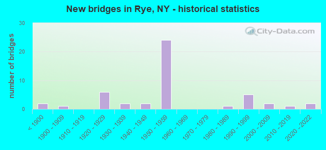
- New bridges - historical statistics
- 2Before 1900
- 11900-1909
- 61920-1929
- 21930-1939
- 21940-1949
- 241950-1959
- 11980-1989
- 51990-1999
- 22000-2009
- 12010-2019
- 22020-2022
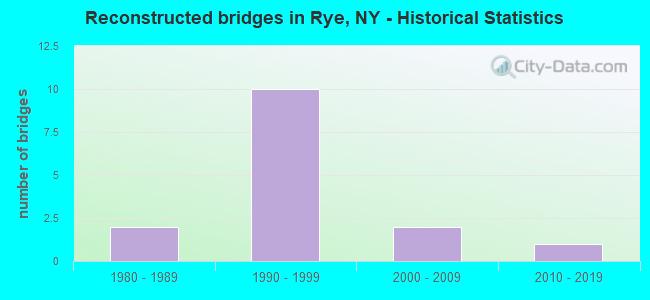
- Reconstructed bridges - Historical Statistics
- 21980-1989
- 101990-1999
- 22000-2009
- 12010-2019
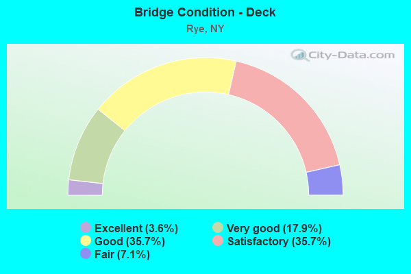
- Bridge Condition - Deck
- 3.6%Excellent
- 17.9%Very good
- 35.7%Good
- 35.7%Satisfactory
- 7.1%Fair
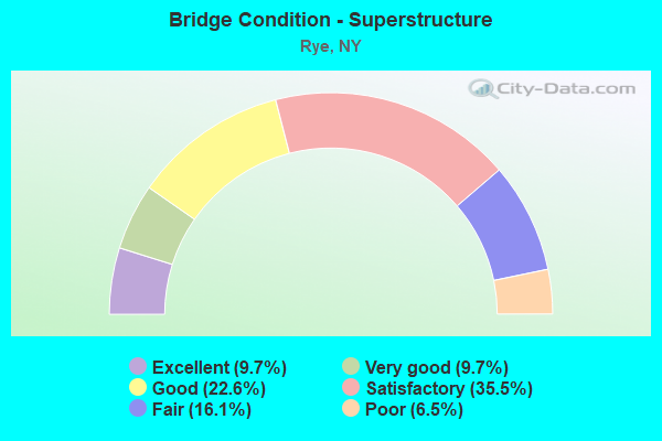
- Bridge Condition - Superstructure
- 9.7%Excellent
- 9.7%Very good
- 22.6%Good
- 35.5%Satisfactory
- 16.1%Fair
- 6.5%Poor
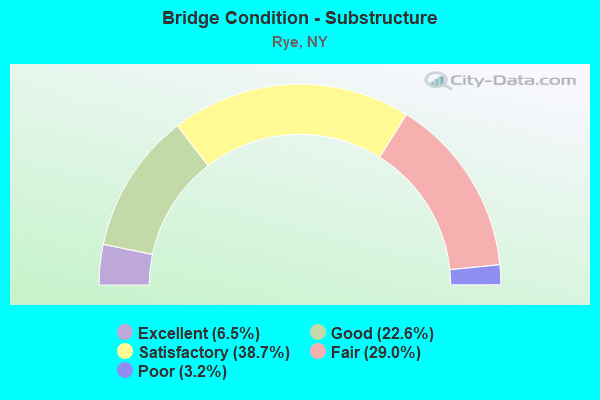
- Bridge Condition - Substructure
- 6.5%Excellent
- 22.6%Good
- 38.7%Satisfactory
- 29.0%Fair
- 3.2%Poor
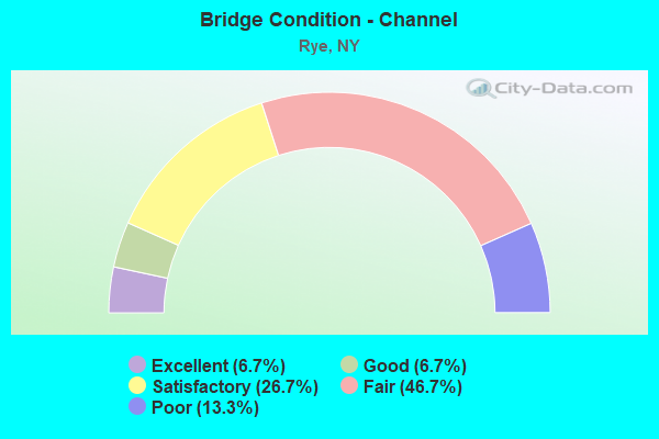
- Bridge Condition - Channel
- 6.7%Excellent
- 6.7%Good
- 26.7%Satisfactory
- 46.7%Fair
- 13.3%Poor
Find on map >> Show street view
Structure Number: 5514779, Location: 0.5 MI SW JCT I-95 & US 1 (Lat: 40.983078, Lng: -73.689111), Route carried "under" structure: City street , Year Built: 1956, Structure Length: 0. m, Average Daily Traffic: 2,155 (year 2020), Truck Traffic: 2%, Features Intersected: LOCUST AVENUE, Facility Carried by Structure: RTE I95
Minimum Vertical Clearance: 4.32m (14.17ft), Kilometerpoint: 0.981, Lanes on structure: 6, Lanes under structure: 2, Material/Design: Steel, Design/Construction: Stringer/Multi-beam, Length of Maximum Span: 16.8m (55.1ft)
Find on map >> Show street view
Structure Number: 5514799, Location: 0.3 MI W JCT I95 & I287 (Lat: 40.987864, Lng: -73.676419), Route carried "under" structure: Ramp Other road , Year Built: 1956, Structure Length: 0. m, Average Daily Traffic: 4,000 (year 2021), Features Intersected: RAMP D OF 95IX, MNRR NH, Facility Carried by Structure: RTE I95
Minimum Vertical Clearance: 8.56m (28.08ft), Kilometerpoint: 0.000, Lanes on structure: 6, Lanes under structure: 2, Toll: On Interstate toll segment, Material/Design: Steel, Design/Construction: Stringer/Multi-beam, Length of Maximum Span: 44.2m (145.0ft)
Find on map >> Show street view
Structure Number: 5514809, Location: .1 MI W JCT RTS 287 & I95 (Lat: 40.987408, Lng: -73.672628), Route carried "under" structure: County highway , Year Built: 2000, Structure Length: 0. m, Average Daily Traffic: 1,723 (year 2016), Truck Traffic: 3%, Features Intersected: MIDLAND AVENUE, Facility Carried by Structure: RTE I95
Minimum Vertical Clearance: 7.72m (25.33ft), Kilometerpoint: 2.462, Lanes on structure: 7, Lanes under structure: 2, Material/Design: Steel, Design/Construction: Stringer/Multi-beam, Length of Maximum Span: 64.6m (211.9ft)
Find on map >> Show street view
Structure Number: 552003, Location: JCT I287 & I95 (Lat: 40.987411, Lng: -73.670431), Route carried "under" structure: Interstate , Year Built: 2020, Structure Length: 0. m, Average Daily Traffic: 147,599 (year 2015), Features Intersected: 95IX - South Bound, 95IX, Facility Carried by Structure: RTE 287
Minimum Vertical Clearance: 6.12m (20.08ft), Kilometerpoint: 22.912, Lanes on structure: 2, Lanes under structure: 2, Toll: On Interstate toll segment, Material/Design: Steel, Design/Construction: Stringer/Multi-beam, Length of Maximum Span: 56.4m (185.0ft)
Find on map >> Show street view
Structure Number: 70373, Location: JCT RR&PURCHASE ST AT RYE (Lat: 40.985567, Lng: -73.684383), Route carried "under" structure: City street 120, Year Built: 1930, Structure Length: 0. m, Average Daily Traffic: 8,300 (year 1977), Features Intersected: RTE 120, Facility Carried by Structure: MNRR NH LINE
Minimum Vertical Clearance: 3.58m (11.75ft), Kilometerpoint: 0.000, Lanes under structure: 2, Material/Design: Steel, Design/Construction: Stringer/Multi-beam, Length of Maximum Span: 15.8m (51.8ft)
Find on map >> Show street view
Structure Number: 771257, Location: 1.8 MI SW OF PORT CHESTER (Lat: 40.982961, Lng: -73.688808), Route carried "under" structure: City street , Year Built: 1905, Structure Length: 0. m, Truck Traffic: 4%, Features Intersected: LOCUST AVENUE, Facility Carried by Structure: MNRR NH LINE
Minimum Vertical Clearance: 2.97m (9.74ft), Kilometerpoint: 0.998, Lanes under structure: 2, Material/Design: Steel, Design/Construction: Girder and Floorbeam System, Length of Maximum Span: 14.3m (46.9ft)