Bridge Statistics for Salina, Kansas (KS)
Condition, Traffic, Stress, Structural Evaluation, Project Costs
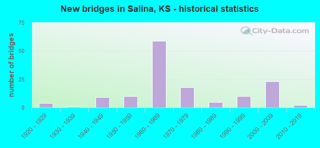
- New bridges - historical statistics
- 41920-1929
- 11930-1939
- 91940-1949
- 101950-1959
- 591960-1969
- 181970-1979
- 51980-1989
- 101990-1999
- 232000-2009
- 22010-2019
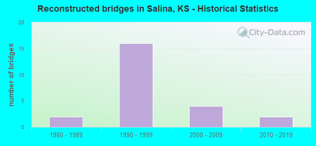
- Reconstructed bridges - Historical Statistics
- 21980-1989
- 161990-1999
- 42000-2009
- 22010-2019
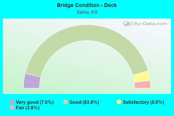
- Bridge Condition - Deck
- 7.5%Very good
- 83.8%Good
- 5.0%Satisfactory
- 3.8%Fair
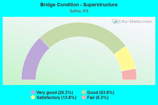
- Bridge Condition - Superstructure
- 26.3%Very good
- 53.8%Good
- 13.8%Satisfactory
- 6.3%Fair
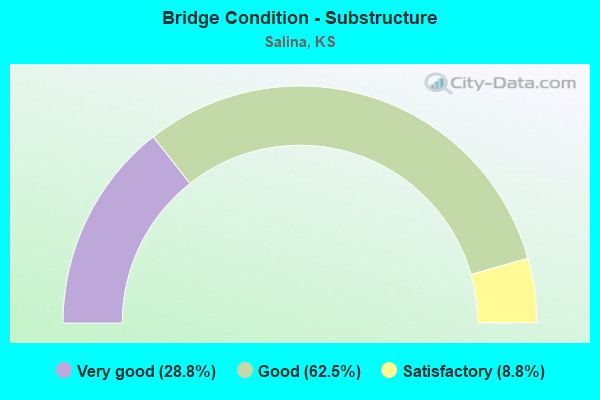
- Bridge Condition - Substructure
- 28.8%Very good
- 62.5%Good
- 8.8%Satisfactory
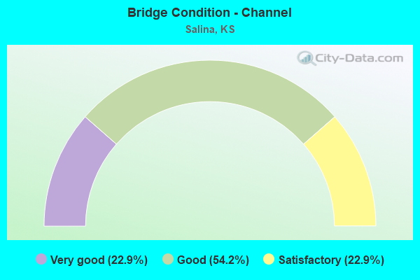
- Bridge Condition - Channel
- 22.9%Very good
- 54.2%Good
- 22.9%Satisfactory
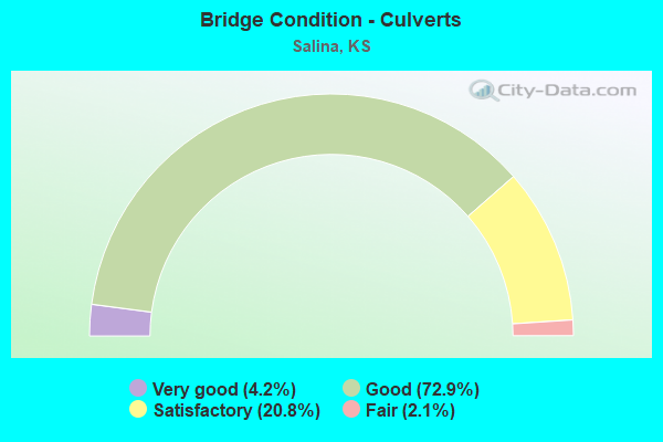
- Bridge Condition - Culverts
- 4.2%Very good
- 72.9%Good
- 20.8%Satisfactory
- 2.1%Fair
Find on map >> Show street view
Structure Number: 85001, Location: 3.1E OF SALINA (Lat: 38.841703, Lng: -97.555836), Route carried "on" structure: County highway 190, Year Built: 1960, Status: Posted for load, Structure Length: 0.76m (2.49ft), Average Daily Traffic: 1,668 (year 2019), Truck Traffic: 6%, Average Future Daily Traffic: 2,035 (year 2043), Features Intersected: LOCAL DRAINAGE
Minimum Vertical Clearance: 30.47m (99.97ft), Kilometerpoint: 0.644, Lanes on structure: 2, Owner: County Highway Agency, Approaching Roadway Width: 7.3m (24.0ft), Material/Design: Concrete, Design/Construction: Culvert, Number Of Spans In Main Unit: 2, Length of Maximum Span: 3.7m (12.1ft), Curb-To-Curb Width: 8.5m (27.9ft), Out-to-Out Width: 9.1m (29.9ft)
Condition: Channel: Satisfactory, Culverts: Good, Operating Rating: 29.4 metric tons, Method Used To Determine Operating Rating: Load Factor (LF), Inventory Rating: 17.6 metric tons, Method Used To Determine Inventory Rating: Load Factor (LF), Structural Evaluation: Meets minimum limits, Deck Geometry: Somewhat better than minimum adequacy, Waterway Adequacy: Equal to present minimum criteria, Approach Roadway Alignment: Equal to present desirable criteria, Length Of Structure Improvement: 0.76m (2.49ft), Designated Inspection Frequency: Every 24 months, Inspection Date: January 2021, Bridge Improvement Cost: $37,000, Roadway Improvement Cost: $4,000, Total Project Cost: $56,000
Find on map >> Show street view
Structure Number: 85002, Location: 3.8E OF SALINA (Lat: 38.841719, Lng: -97.543231), Route carried "on" structure: County highway 190, Year Built: 1960, Status: Open, Structure Length: 1.80m (5.91ft), Average Daily Traffic: 2,470 (year 2020), Truck Traffic: 6%, Average Future Daily Traffic: 1,674 (year 2043), Design Load: H 15, Features Intersected: EAST DRY CREEK
Minimum Vertical Clearance: 30.47m (99.97ft), Kilometerpoint: 1.722, Lanes on structure: 2, Owner: County Highway Agency, Approaching Roadway Width: 7.3m (24.0ft), Material/Design: Concrete, Design/Construction: Culvert, Number Of Spans In Main Unit: 4, Length of Maximum Span: 4.3m (14.1ft), Curb-To-Curb Width: 8.5m (27.9ft), Out-to-Out Width: 9.1m (29.9ft)
Condition: Channel: Satisfactory, Culverts: Good, Operating Rating: 54.4 metric tons, Method Used To Determine Operating Rating: Field evaluation and documented engineering judgment, Inventory Rating: 32.7 metric tons, Method Used To Determine Inventory Rating: Field evaluation and documented engineering judgment, Structural Evaluation: Better than present minimum criteria, Deck Geometry: Meets minimum limits, Waterway Adequacy: Equal to present minimum criteria, Approach Roadway Alignment: Equal to present desirable criteria, Length Of Structure Improvement: 2.01m (6.59ft), Designated Inspection Frequency: Every 24 months, Inspection Date: Febuary 2021, Bridge Improvement Cost: $150,000, Roadway Improvement Cost: $25,000, Total Project Cost: $200,000
Find on map >> Show street view
Structure Number: 85029, Location: 4.0W 0.9S OF SALINA (Lat: 38.829456, Lng: -97.686647), Route carried "on" structure: County highway 450, Year Built: 1981, Status: Open, Structure Length: 1.95m (6.40ft), Average Daily Traffic: 478 (year 2020), Truck Traffic: 6%, Average Future Daily Traffic: 584 (year 2043), Design Load: H 20, Features Intersected: LOCAL DRAINAGE
Minimum Vertical Clearance: 30.47m (99.97ft), Kilometerpoint: 24.376, Lanes on structure: 2, Owner: County Highway Agency, Approaching Roadway Width: 7.3m (24.0ft), Material/Design: Concrete, Design/Construction: Culvert, Number Of Spans In Main Unit: 6, Length of Maximum Span: 3.0m (9.8ft), Curb-To-Curb Width: 11.0m (36.1ft), Out-to-Out Width: 11.4m (37.4ft)
Condition: Channel: Good, Culverts: Good, Operating Rating: 30.6 metric tons, Method Used To Determine Operating Rating: Allowable Stress (AS), Inventory Rating: 19.8 metric tons, Method Used To Determine Inventory Rating: Allowable Stress (AS), Structural Evaluation: Somewhat better than minimum adequacy, Deck Geometry: Better than present minimum criteria, Waterway Adequacy: Equal to present desirable criteria, Approach Roadway Alignment: Equal to present desirable criteria, Length Of Structure Improvement: 2.13m (6.99ft), Designated Inspection Frequency: Every 24 months, Inspection Date: Febuary 2021, Bridge Improvement Cost: $100,000, Roadway Improvement Cost: $35,000, Total Project Cost: $165,000
Find on map >> Show street view
Structure Number: 85039, Location: 2.5E OF SHIPTON (Lat: 38.914389, Lng: -97.640953), Route carried "on" structure: County highway 523, Year Built: 1952, Year Reconstructed: 2004, Status: Open, Structure Length: 8.32m (27.30ft), Average Daily Traffic: 137 (year 2017), Truck Traffic: 6%, Average Future Daily Traffic: 167 (year 2043), Design Load: HS 20, Features Intersected: SALINE RIVER
Minimum Vertical Clearance: 30.47m (99.97ft), Kilometerpoint: 11.183, Lanes on structure: 2, Owner: County Highway Agency, Approaching Roadway Width: 7.3m (24.0ft), Material/Design: Steel continuous, Design/Construction: Stringer/Multi-beam, Number Of Spans In Main Unit: 3, Length of Maximum Span: 31.7m (104.0ft), Curb-To-Curb Width: 8.6m (28.2ft), Out-to-Out Width: 9.2m (30.2ft)
Condition: Deck: Very good, Superstructure: Very good, Substructure: Good, Channel: Good, Operating Rating: 85.3 metric tons, Method Used To Determine Operating Rating: Load and Resistance Factor (LRFR), Inventory Rating: 51.2 metric tons, Method Used To Determine Inventory Rating: Load and Resistance Factor (LRFR), Structural Evaluation: Better than present minimum criteria, Deck Geometry: Equal to present minimum criteria, Waterway Adequacy: Equal to present desirable criteria, Approach Roadway Alignment: Superior to present desirable criteria, Designated Inspection Frequency: Every 24 months, Inspection Date: Febuary 2021, Deck Structure Type: Concrete Cast-file-Place, Wearing Surface/Protective System: Deck Protection: Epoxy Coated Reinforcing
Find on map >> Show street view
Structure Number: 85043, Location: 5.2W OF SALINA (Lat: 38.841781, Lng: -97.708583), Route carried "on" structure: County highway 592, Year Built: 1997, Status: Open, Structure Length: 4.94m (16.21ft), Average Daily Traffic: 1,059 (year 2017), Truck Traffic: 6%, Average Future Daily Traffic: 1,292 (year 2043), Design Load: HS 20, Features Intersected: MULBERRY CREEK
Minimum Vertical Clearance: 30.47m (99.97ft), Kilometerpoint: 14.159, Lanes on structure: 2, Owner: County Highway Agency, Approaching Roadway Width: 7.3m (24.0ft), Skew: 3 degrees, Material/Design: Concrete continuous, Design/Construction: Slab, Number Of Spans In Main Unit: 3, Length of Maximum Span: 19.5m (64.0ft), Curb-To-Curb Width: 9.8m (32.2ft), Out-to-Out Width: 10.4m (34.1ft)
Condition: Deck: Good, Superstructure: Good, Substructure: Very good, Channel: Good, Operating Rating: 77.6 metric tons, Method Used To Determine Operating Rating: Load Factor (LF), Inventory Rating: 46.4 metric tons, Method Used To Determine Inventory Rating: Load Factor (LF), Structural Evaluation: Better than present minimum criteria, Deck Geometry: Somewhat better than minimum adequacy, Waterway Adequacy: Equal to present minimum criteria, Approach Roadway Alignment: Equal to present desirable criteria, Designated Inspection Frequency: Every 24 months, Inspection Date: Febuary 2021, Deck Structure Type: Concrete Cast-file-Place, Wearing Surface/Protective System: Deck Protection: Epoxy Coated Reinforcing
Find on map >> Show street view
Structure Number: 85044, Location: 3.2W OF SALINA (Lat: 38.841581, Lng: -97.691067), Route carried "on" structure: County highway 592, Year Built: 2007, Status: Open, Structure Length: 9.88m (32.41ft), Average Daily Traffic: 1,232 (year 2017), Truck Traffic: 6%, Average Future Daily Traffic: 1,503 (year 2043), Design Load: HS 20+Mod, Features Intersected: MULBERRY CREEK
Minimum Vertical Clearance: 30.47m (99.97ft), Kilometerpoint: 15.768, Lanes on structure: 2, Owner: County Highway Agency, Approaching Roadway Width: 7.3m (24.0ft), Skew: 3 degrees, Material/Design: Concrete continuous, Design/Construction: Slab, Number Of Spans In Main Unit: 5, Length of Maximum Span: 21.9m (71.9ft), Curb-To-Curb Width: 10.4m (34.1ft), Out-to-Out Width: 11.0m (36.1ft)
Condition: Deck: Good, Superstructure: Very good, Substructure: Very good, Channel: Good, Operating Rating: 80.5 metric tons, Method Used To Determine Operating Rating: Allowable Stress (AS), Inventory Rating: 48.2 metric tons, Method Used To Determine Inventory Rating: Allowable Stress (AS), Structural Evaluation: Equal to present desirable criteria, Deck Geometry: Equal to present minimum criteria, Waterway Adequacy: Equal to present desirable criteria, Approach Roadway Alignment: Equal to present desirable criteria, Designated Inspection Frequency: Every 24 months, Inspection Date: Febuary 2021, Deck Structure Type: Concrete Cast-file-Place, Wearing Surface/Protective System: Wearing Surface: Monolithic Concrete, Deck Protection: Epoxy Coated Reinforcing
Find on map >> Show street view
Structure Number: 85045, Location: 0.4W OF SALINA (Lat: 38.841667, Lng: -97.637483), Route carried "on" structure: County highway 4844, Year Built: 1962, Status: Posted for load, Structure Length: 1.34m (4.40ft), Average Daily Traffic: 7,001 (year 2017), Truck Traffic: 6%, Average Future Daily Traffic: 8,541 (year 2043), Design Load: H 20, Features Intersected: LOCAL DRAINAGE
Minimum Vertical Clearance: 30.47m (99.97ft), Kilometerpoint: 20.306, Lanes on structure: 2, Owner: County Highway Agency, Approaching Roadway Width: 10.3m (33.8ft), Skew: 4 degrees, Material/Design: Concrete, Design/Construction: Culvert, Number Of Spans In Main Unit: 3, Length of Maximum Span: 4.3m (14.1ft)
Condition: Channel: Satisfactory, Culverts: Satisfactory, Operating Rating: 31.5 metric tons, Method Used To Determine Operating Rating: Load Factor (LF), Inventory Rating: 18.9 metric tons, Method Used To Determine Inventory Rating: Load Factor (LF), Structural Evaluation: Meets minimum limits, Waterway Adequacy: Equal to present minimum criteria, Approach Roadway Alignment: Equal to present desirable criteria, Bridge Posting: Required (Relationship of Operating Rating to Maximum Legal Load: 20.0 - 29.9% below), Length Of Structure Improvement: 1.52m (4.99ft), Designated Inspection Frequency: Every 24 months, Inspection Date: Febuary 2021, Other Special Inspection Date: November 2020, Bridge Improvement Cost: $75,000, Roadway Improvement Cost: $15,000, Total Project Cost: $100,000
Find on map >> Show street view
Structure Number: 85048, Location: 1.2W OF MENTOR (Lat: 38.740069, Lng: -97.626500), Route carried "on" structure: County highway 593, Year Built: 2004, Status: Open, Structure Length: 0.68m (2.23ft), Average Daily Traffic: 454 (year 2020), Truck Traffic: 6%, Average Future Daily Traffic: 613 (year 2043), Design Load: HS 20+Mod, Features Intersected: DRY CREEK
Minimum Vertical Clearance: 30.47m (99.97ft), Kilometerpoint: 5.310, Lanes on structure: 2, Owner: County Highway Agency, Approaching Roadway Width: 7.3m (24.0ft), Material/Design: Concrete, Design/Construction: Culvert, Number Of Spans In Main Unit: 2, Length of Maximum Span: 3.0m (9.8ft), Curb-To-Curb Width: 9.2m (30.2ft), Out-to-Out Width: 25.9m (85.0ft)
Condition: Channel: Good, Culverts: Good, Operating Rating: 68.6 metric tons, Method Used To Determine Operating Rating: Allowable Stress (AS), Inventory Rating: 41.1 metric tons, Method Used To Determine Inventory Rating: Allowable Stress (AS), Structural Evaluation: Better than present minimum criteria, Deck Geometry: Equal to present minimum criteria, Waterway Adequacy: Equal to present desirable criteria, Approach Roadway Alignment: Equal to present desirable criteria, Designated Inspection Frequency: Every 24 months, Inspection Date: Febuary 2021
Find on map >> Show street view
Structure Number: 8507, Location: 1.0S 4.0W OF SALINA (Lat: 38.827183, Lng: -97.691400), Route carried "on" structure: County highway 1057, Year Built: 1962, Status: Open, Structure Length: 2.56m (8.40ft), Average Daily Traffic: 1,615 (year 2020), Truck Traffic: 6%, Average Future Daily Traffic: 2,249 (year 2043), Design Load: H 15, Features Intersected: LOCAL DRAINAGE
Minimum Vertical Clearance: 30.47m (99.97ft), Kilometerpoint: 0.209, Lanes on structure: 2, Owner: County Highway Agency, Approaching Roadway Width: 7.3m (24.0ft), Material/Design: Concrete, Design/Construction: Culvert, Number Of Spans In Main Unit: 8, Length of Maximum Span: 3.0m (9.8ft), Curb-To-Curb Width: 9.8m (32.2ft), Out-to-Out Width: 10.4m (34.1ft)
Condition: Channel: Good, Culverts: Satisfactory, Operating Rating: 31.5 metric tons, Method Used To Determine Operating Rating: Allowable Stress (AS), Inventory Rating: 19.8 metric tons, Method Used To Determine Inventory Rating: Allowable Stress (AS), Structural Evaluation: Somewhat better than minimum adequacy, Deck Geometry: Somewhat better than minimum adequacy, Waterway Adequacy: Equal to present minimum criteria, Approach Roadway Alignment: Equal to present desirable criteria, Designated Inspection Frequency: Every 24 months, Inspection Date: Febuary 2021
Find on map >> Show street view
Structure Number: 85071, Location: 1.0S 3.0W OF SALINA (Lat: 38.827150, Lng: -97.676172), Route carried "on" structure: County highway 1057, Year Built: 1962, Status: Open, Structure Length: 0.76m (2.49ft), Average Daily Traffic: 2,398 (year 2015), Truck Traffic: 6%, Average Future Daily Traffic: 2,878 (year 2043), Design Load: H 15, Features Intersected: LOCAL DRAINAGE
Minimum Vertical Clearance: 30.47m (99.97ft), Kilometerpoint: 1.609, Lanes on structure: 2, Owner: County Highway Agency, Approaching Roadway Width: 7.3m (24.0ft), Material/Design: Concrete, Design/Construction: Culvert, Number Of Spans In Main Unit: 3, Length of Maximum Span: 2.4m (7.9ft)
Condition: Channel: Good, Culverts: Good, Operating Rating: 25.2 metric tons, Method Used To Determine Operating Rating: Allowable Stress (AS), Inventory Rating: 16.2 metric tons, Method Used To Determine Inventory Rating: Allowable Stress (AS), Structural Evaluation: Meets minimum limits, Waterway Adequacy: Equal to present minimum criteria, Approach Roadway Alignment: Equal to present desirable criteria, Length Of Structure Improvement: 0.91m (2.99ft), Designated Inspection Frequency: Every 24 months, Inspection Date: Febuary 2021, Bridge Improvement Cost: $40,000, Roadway Improvement Cost: $10,000, Total Project Cost: $75,000
Find on map >> Show street view
Structure Number: 85072, Location: 1.0S 1.6W OF SALINA (Lat: 38.827147, Lng: -97.652403), Route carried "on" structure: County highway 1057, Year Built: 1962, Status: Open, Structure Length: 0.64m (2.10ft), Average Daily Traffic: 2,954 (year 2017), Truck Traffic: 6%, Average Future Daily Traffic: 3,604 (year 2043), Design Load: H 15, Features Intersected: LOCAL DRAINAGE
Minimum Vertical Clearance: 30.47m (99.97ft), Kilometerpoint: 4.023, Lanes on structure: 2, Owner: County Highway Agency, Approaching Roadway Width: 7.9m (25.9ft), Material/Design: Concrete, Design/Construction: Culvert, Number Of Spans In Main Unit: 2, Length of Maximum Span: 3.0m (9.8ft), Curb-To-Curb Width: 9.8m (32.2ft), Out-to-Out Width: 10.4m (34.1ft)
Condition: Channel: Good, Culverts: Good, Operating Rating: 24.3 metric tons, Method Used To Determine Operating Rating: Allowable Stress (AS), Inventory Rating: 12.6 metric tons, Method Used To Determine Inventory Rating: Allowable Stress (AS), Structural Evaluation: Meets minimum limits, Deck Geometry: Meets minimum limits, Waterway Adequacy: Equal to present minimum criteria, Approach Roadway Alignment: Equal to present desirable criteria, Length Of Structure Improvement: 0.91m (2.99ft), Designated Inspection Frequency: Every 24 months, Inspection Date: Febuary 2021, Bridge Improvement Cost: $40,000, Roadway Improvement Cost: $10,000, Total Project Cost: $75,000
Find on map >> Show street view
Structure Number: 85073, Location: 1.0S 1.5W OF SALINA (Lat: 38.827147, Lng: -97.646469), Route carried "on" structure: County highway 1057, Year Built: 1962, Status: Open, Structure Length: 1.62m (5.31ft), Average Daily Traffic: 3,074 (year 2017), Truck Traffic: 6%, Average Future Daily Traffic: 3,750 (year 2043), Design Load: H 15, Features Intersected: LOCAL DRAINAGE
Minimum Vertical Clearance: 30.47m (99.97ft), Kilometerpoint: 4.103, Lanes on structure: 2, Owner: County Highway Agency, Approaching Roadway Width: 7.9m (25.9ft), Material/Design: Concrete, Design/Construction: Culvert, Number Of Spans In Main Unit: 5, Length of Maximum Span: 3.0m (9.8ft), Curb-To-Curb Width: 9.8m (32.2ft), Out-to-Out Width: 10.4m (34.1ft)
Condition: Channel: Good, Culverts: Good, Operating Rating: 31.5 metric tons, Method Used To Determine Operating Rating: Allowable Stress (AS), Inventory Rating: 18.9 metric tons, Method Used To Determine Inventory Rating: Allowable Stress (AS), Structural Evaluation: Somewhat better than minimum adequacy, Deck Geometry: Meets minimum limits, Waterway Adequacy: Equal to present minimum criteria, Approach Roadway Alignment: Equal to present desirable criteria, Length Of Structure Improvement: 1.83m (6.00ft), Designated Inspection Frequency: Every 24 months, Inspection Date: Febuary 2021, Bridge Improvement Cost: $75,000, Roadway Improvement Cost: $15,000, Total Project Cost: $120,000
Find on map >> Show street view
Structure Number: 85074, Location: 1.0S 4.0E OF SALINA (Lat: 38.827200, Lng: -97.550381), Route carried "on" structure: County highway 1057, Year Built: 1999, Status: Open, Structure Length: 1.34m (4.40ft), Average Daily Traffic: 1,725 (year 2020), Truck Traffic: 6%, Average Future Daily Traffic: 2,004 (year 2043), Design Load: HS 20, Features Intersected: LOCAL DRAINAGE
Minimum Vertical Clearance: 30.47m (99.97ft), Kilometerpoint: 12.711, Lanes on structure: 2, Owner: County Highway Agency, Approaching Roadway Width: 7.3m (24.0ft), Material/Design: Concrete, Design/Construction: Culvert, Number Of Spans In Main Unit: 4, Length of Maximum Span: 3.0m (9.8ft), Curb-To-Curb Width: 9.1m (29.9ft), Out-to-Out Width: 12.6m (41.3ft)
Condition: Channel: Good, Culverts: Good, Operating Rating: 74.7 metric tons, Method Used To Determine Operating Rating: Allowable Stress (AS), Inventory Rating: 44.1 metric tons, Method Used To Determine Inventory Rating: Allowable Stress (AS), Structural Evaluation: Better than present minimum criteria, Deck Geometry: Somewhat better than minimum adequacy, Waterway Adequacy: Equal to present minimum criteria, Approach Roadway Alignment: Equal to present desirable criteria, Designated Inspection Frequency: Every 24 months, Inspection Date: Febuary 2021
Find on map >> Show street view
Structure Number: 85075, Location: 1.7S 4.6E OF SALINA (Lat: 38.816025, Lng: -97.539064), Route carried "on" structure: County highway 1057, Year Built: 2001, Status: Open, Structure Length: 1.10m (3.61ft), Average Daily Traffic: 1,453 (year 2017), Truck Traffic: 6%, Average Future Daily Traffic: 1,773 (year 2043), Design Load: HS 20+Mod, Features Intersected: LOCAL DRAINAGE
Minimum Vertical Clearance: 30.47m (99.97ft), Kilometerpoint: 14.803, Lanes on structure: 2, Owner: County Highway Agency, Approaching Roadway Width: 7.3m (24.0ft), Skew: 3 degrees, Material/Design: Concrete, Design/Construction: Culvert, Number Of Spans In Main Unit: 3, Length of Maximum Span: 3.5m (11.5ft)
Condition: Channel: Satisfactory, Culverts: Good, Operating Rating: 90.1 metric tons, Method Used To Determine Operating Rating: Allowable Stress (AS), Inventory Rating: 54.0 metric tons, Method Used To Determine Inventory Rating: Allowable Stress (AS), Structural Evaluation: Better than present minimum criteria, Waterway Adequacy: Equal to present desirable criteria, Approach Roadway Alignment: Superior to present desirable criteria, Designated Inspection Frequency: Every 24 months, Inspection Date: Febuary 2021
Find on map >> Show street view
Structure Number: 85086, Location: 3.0W 0.2N OF SALINA (Lat: 38.844342, Lng: -97.668222), Route carried "on" structure: County highway 1710, Year Built: 1956, Year Reconstructed: 2018, Status: Open, Structure Length: 8.50m (27.89ft), Average Daily Traffic: 1,336 (year 2017), Truck Traffic: 6%, Average Future Daily Traffic: 1,634 (year 2043), Design Load: HL 93, Features Intersected: MULBERRY CREEK
Minimum Vertical Clearance: 30.47m (99.97ft), Kilometerpoint: 0.322, Lanes on structure: 2, Owner: County Highway Agency, Approaching Roadway Width: 7.3m (24.0ft), Material/Design: Concrete, Design/Construction: Stringer/Multi-beam, Number Of Spans In Main Unit: 5, Length of Maximum Span: 18.3m (60.0ft), Curb-To-Curb Width: 9.1m (29.9ft), Out-to-Out Width: 9.8m (32.2ft)
Condition: Deck: Very good, Superstructure: Very good, Substructure: Good, Channel: Good, Operating Rating: 66.6 metric tons, Method Used To Determine Operating Rating: Allowable Stress (AS), Inventory Rating: 38.2 metric tons, Method Used To Determine Inventory Rating: Allowable Stress (AS), Structural Evaluation: Better than present minimum criteria, Deck Geometry: Somewhat better than minimum adequacy, Waterway Adequacy: Better than present minimum criteria, Approach Roadway Alignment: Equal to present desirable criteria, Designated Inspection Frequency: Every 24 months, Inspection Date: Febuary 2021, Deck Structure Type: Concrete Cast-file-Place, Wearing Surface/Protective System: Wearing Surface: Monolithic Concrete, Deck Protection: Epoxy Coated Reinforcing
Find on map >> Show street view
Structure Number: 85087, Location: 3.0W 0.7N OF SALINA (Lat: 38.852547, Lng: -97.668228), Route carried "on" structure: County highway 1710, Year Built: 1958, Status: Open, Structure Length: 1.49m (4.89ft), Average Daily Traffic: 1,322 (year 2017), Truck Traffic: 6%, Average Future Daily Traffic: 1,613 (year 2043), Design Load: H 15, Features Intersected: LOCAL DRAINAGE
Minimum Vertical Clearance: 30.47m (99.97ft), Kilometerpoint: 1.175, Lanes on structure: 2, Owner: County Highway Agency, Approaching Roadway Width: 7.3m (24.0ft), Material/Design: Concrete, Design/Construction: Culvert, Number Of Spans In Main Unit: 5, Length of Maximum Span: 2.7m (8.9ft)
Condition: Channel: Satisfactory, Culverts: Good, Operating Rating: 27.0 metric tons, Method Used To Determine Operating Rating: Allowable Stress (AS), Inventory Rating: 16.2 metric tons, Method Used To Determine Inventory Rating: Allowable Stress (AS), Structural Evaluation: Meets minimum limits, Waterway Adequacy: Equal to present minimum criteria, Approach Roadway Alignment: Equal to present desirable criteria, Length Of Structure Improvement: 1.52m (4.99ft), Designated Inspection Frequency: Every 24 months, Inspection Date: Febuary 2021, Bridge Improvement Cost: $75,000, Roadway Improvement Cost: $15,000, Total Project Cost: $100,000, Wearing Surface/Protective System: Wearing Surface: Bituminous
Find on map >> Show street view
Structure Number: 85088, Location: 4.0E 0.4N OF SALINA (Lat: 38.848983, Lng: -97.538886), Route carried "on" structure: County highway 1763, Year Built: 1966, Status: Open, Structure Length: 1.40m (4.59ft), Average Daily Traffic: 1,680 (year 2020), Truck Traffic: 6%, Average Future Daily Traffic: 1,740 (year 2043), Design Load: H 20, Features Intersected: EAST DRY CREEK
Minimum Vertical Clearance: 30.47m (99.97ft), Kilometerpoint: 2.301, Lanes on structure: 2, Owner: County Highway Agency, Approaching Roadway Width: 7.6m (24.9ft), Skew: 4 degrees, Material/Design: Concrete, Design/Construction: Culvert, Number Of Spans In Main Unit: 2, Length of Maximum Span: 7.0m (23.0ft)
Condition: Channel: Satisfactory, Culverts: Good, Operating Rating: 63.9 metric tons, Method Used To Determine Operating Rating: Allowable Stress (AS), Inventory Rating: 40.5 metric tons, Method Used To Determine Inventory Rating: Allowable Stress (AS), Structural Evaluation: Better than present minimum criteria, Waterway Adequacy: Better than present minimum criteria, Approach Roadway Alignment: Equal to present desirable criteria, Designated Inspection Frequency: Every 24 months, Inspection Date: Febuary 2021
Find on map >> Show street view
Structure Number: 85089, Location: 4.0E 1.3N OF SALINA (Lat: 38.860644, Lng: -97.538917), Route carried "on" structure: County highway 1763, Year Built: 2006, Status: Open, Structure Length: 9.49m (31.14ft), Average Daily Traffic: 1,981 (year 2017), Truck Traffic: 10%, Average Future Daily Traffic: 2,417 (year 2043), Design Load: HS 20+Mod, Features Intersected: SMOKY HILL RIVER
Minimum Vertical Clearance: 30.47m (99.97ft), Kilometerpoint: 3.733, Lanes on structure: 2, Owner: County Highway Agency, Approaching Roadway Width: 7.3m (24.0ft), Material/Design: Prestressed concrete continuous, Design/Construction: Stringer/Multi-beam, Number Of Spans In Main Unit: 3, Length of Maximum Span: 31.4m (103.0ft), Curb-To-Curb Width: 9.8m (32.2ft), Out-to-Out Width: 10.4m (34.1ft)
Condition: Deck: Good, Superstructure: Very good, Substructure: Very good, Channel: Good, Operating Rating: 60.7 metric tons, Method Used To Determine Operating Rating: Load and Resistance Factor (LRFR), Inventory Rating: 36.3 metric tons, Method Used To Determine Inventory Rating: Load and Resistance Factor (LRFR), Structural Evaluation: Equal to present desirable criteria, Deck Geometry: Somewhat better than minimum adequacy, Waterway Adequacy: Meets minimum limits, Approach Roadway Alignment: Equal to present desirable criteria, Designated Inspection Frequency: Every 24 months, Inspection Date: Febuary 2021, Deck Structure Type: Concrete Cast-file-Place, Wearing Surface/Protective System: Wearing Surface: Monolithic Concrete, Deck Protection: Epoxy Coated Reinforcing
Find on map >> Show street view
Structure Number: 8509, Location: 1.0E 3.2N OF SALINA (Lat: 38.887653, Lng: -97.593653), Route carried "on" structure: County highway 1778, Year Built: 2007, Status: Open, Structure Length: 12.50m (41.01ft), Average Daily Traffic: 1,265 (year 2017), Truck Traffic: 6%, Average Future Daily Traffic: 1,544 (year 2043), Design Load: HS 20, Features Intersected: SALINE RIVER
Minimum Vertical Clearance: 30.47m (99.97ft), Kilometerpoint: 2.735, Lanes on structure: 2, Owner: County Highway Agency, Approaching Roadway Width: 10.3m (33.8ft), Skew: 3 degrees, Material/Design: Steel continuous, Design/Construction: Stringer/Multi-beam, Number Of Spans In Main Unit: 3, Length of Maximum Span: 48.2m (158.1ft), Curb-To-Curb Width: 10.4m (34.1ft), Out-to-Out Width: 11.0m (36.1ft)
Condition: Deck: Good, Superstructure: Very good, Substructure: Very good, Channel: Very good, Operating Rating: 61.3 metric tons, Method Used To Determine Operating Rating: Load Factor (LF), Inventory Rating: 36.7 metric tons, Method Used To Determine Inventory Rating: Load Factor (LF), Structural Evaluation: Equal to present desirable criteria, Deck Geometry: Equal to present minimum criteria, Waterway Adequacy: Equal to present desirable criteria, Approach Roadway Alignment: Equal to present desirable criteria, Designated Inspection Frequency: Every 24 months, Inspection Date: Febuary 2021, Deck Structure Type: Concrete Cast-file-Place, Wearing Surface/Protective System: Deck Protection: Epoxy Coated Reinforcing
Find on map >> Show street view
Structure Number: 85097, Location: 1.2E OF MENTOR (Lat: 38.740431, Lng: -97.580622), Route carried "on" structure: County highway 1944, Year Built: 1982, Status: Open, Structure Length: 10.85m (35.60ft), Average Daily Traffic: 79 (year 2019), Truck Traffic: 6%, Average Future Daily Traffic: 96 (year 2043), Design Load: H 20, Features Intersected: SMOKY HILL RIVER
Minimum Vertical Clearance: 30.47m (99.97ft), Kilometerpoint: 2.751, Lanes on structure: 2, Owner: County Highway Agency, Approaching Roadway Width: 7.3m (24.0ft), Skew: 4 degrees, Material/Design: Prestressed concrete continuous, Design/Construction: Stringer/Multi-beam, Number Of Spans In Main Unit: 4, Length of Maximum Span: 26.8m (87.9ft), Curb-To-Curb Width: 8.5m (27.9ft), Out-to-Out Width: 9.1m (29.9ft)
Condition: Deck: Good, Superstructure: Good, Substructure: Good, Channel: Good, Operating Rating: 44.5 metric tons, Method Used To Determine Operating Rating: Load Factor (LF), Inventory Rating: 25.5 metric tons, Method Used To Determine Inventory Rating: Load Factor (LF), Structural Evaluation: Equal to present minimum criteria, Deck Geometry: Better than present minimum criteria, Waterway Adequacy: Better than present minimum criteria, Approach Roadway Alignment: Somewhat better than minimum adequacy, Designated Inspection Frequency: Every 24 months, Inspection Date: Febuary 2021, Deck Structure Type: Concrete Cast-file-Place, Wearing Surface/Protective System: Wearing Surface: Epoxy Overlay, Membrane: Epoxy
Find on map >> Show street view
Structure Number: 851, Location: 2.3 E OF I-135 (Lat: 38.798217, Lng: -97.575014), Route carried "on" structure: City street , Year Built: 1958, Status: Open, Structure Length: 6.77m (22.21ft), Average Daily Traffic: 4,870 (year 2014), Truck Traffic: 6%, Average Future Daily Traffic: 7,700 (year 2043), Design Load: H 15, Features Intersected: SMOKY HILL RIVER, Facility Carried by Structure: MAGNOLIA ROAD
Minimum Vertical Clearance: 30.47m (99.97ft), Kilometerpoint: 1.609, Lanes on structure: 2, Owner: City or Municipal Highway Agency, Approaching Roadway Width: 7.3m (24.0ft), Material/Design: Concrete continuous, Design/Construction: Box Beam or Girders - Multiple, Number Of Spans In Main Unit: 3, Length of Maximum Span: 25.9m (85.0ft), Curb-To-Curb Width: 7.3m (24.0ft), Out-to-Out Width: 7.9m (25.9ft)
Condition: Deck: Good, Superstructure: Good, Substructure: Good, Channel: Good, Operating Rating: 27.4 metric tons, Method Used To Determine Operating Rating: Load Factor (LF), Inventory Rating: 16.4 metric tons, Method Used To Determine Inventory Rating: Load Factor (LF), Structural Evaluation: Meets minimum limits, Deck Geometry: High priority of replacement, Waterway Adequacy: Better than present minimum criteria, Approach Roadway Alignment: Equal to present desirable criteria, Length Of Structure Improvement: 6.77m (22.21ft), Designated Inspection Frequency: Every 24 months, Inspection Date: November 2021, Bridge Improvement Cost: $283,000, Roadway Improvement Cost: $28,000, Total Project Cost: $424,000, Deck Structure Type: Concrete Cast-file-Place, Wearing Surface/Protective System: Wearing Surface: Low Slump Concrete
Find on map >> Show street view
Structure Number: 85101, Location: 3.4E 3.0S OF SALINA (Lat: 38.798194, Lng: -97.550436), Route carried "on" structure: County highway 1057, Year Built: 1972, Status: Open, Structure Length: 0.98m (3.22ft), Average Daily Traffic: 1,725 (year 2020), Truck Traffic: 6%, Average Future Daily Traffic: 1,052 (year 2043), Design Load: H 20, Features Intersected: EAST DRY CREEK
Minimum Vertical Clearance: 30.47m (99.97ft), Kilometerpoint: 3.862, Lanes on structure: 2, Owner: County Highway Agency, Approaching Roadway Width: 7.3m (24.0ft), Material/Design: Concrete, Design/Construction: Culvert, Number Of Spans In Main Unit: 3, Length of Maximum Span: 3.0m (9.8ft), Curb-To-Curb Width: 11.4m (37.4ft), Out-to-Out Width: 11.9m (39.0ft)
Condition: Channel: Good, Culverts: Good, Operating Rating: 28.8 metric tons, Method Used To Determine Operating Rating: Allowable Stress (AS), Inventory Rating: 18.0 metric tons, Method Used To Determine Inventory Rating: Allowable Stress (AS), Structural Evaluation: Somewhat better than minimum adequacy, Deck Geometry: Equal to present minimum criteria, Waterway Adequacy: Equal to present minimum criteria, Approach Roadway Alignment: Equal to present desirable criteria, Length Of Structure Improvement: 1.07m (3.51ft), Designated Inspection Frequency: Every 24 months, Inspection Date: Febuary 2021, Bridge Improvement Cost: $50,000, Roadway Improvement Cost: $15,000, Total Project Cost: $80,000
Find on map >> Show street view
Structure Number: 85102, Location: 1.0W 0.4N OF SALINA (Lat: 38.848903, Lng: -97.623511), Route carried "on" structure: County highway , Year Built: 2003, Status: Open, Structure Length: 1.30m (4.27ft), Average Daily Traffic: 4,497 (year 2017), Truck Traffic: 6%, Average Future Daily Traffic: 5,486 (year 2043), Design Load: HS 20+Mod, Features Intersected: DRY CREEK DIVERSION, Facility Carried by Structure: FAU 4844 458.9-789
Minimum Vertical Clearance: 30.47m (99.97ft), Kilometerpoint: 0.000, Lanes on structure: 2, Owner: County Highway Agency, Approaching Roadway Width: 7.5m (24.6ft), Material/Design: Concrete, Design/Construction: Culvert, Number Of Spans In Main Unit: 2, Length of Maximum Span: 6.1m (20.0ft), Curb-To-Curb Width: 11.0m (36.1ft), Out-to-Out Width: 11.6m (38.1ft)
Condition: Channel: Good, Culverts: Good, Operating Rating: 90.6 metric tons, Method Used To Determine Operating Rating: Allowable Stress (AS), Inventory Rating: 67.4 metric tons, Method Used To Determine Inventory Rating: Allowable Stress (AS), Structural Evaluation: Better than present minimum criteria, Deck Geometry: Somewhat better than minimum adequacy, Waterway Adequacy: Equal to present desirable criteria, Approach Roadway Alignment: Equal to present desirable criteria, Designated Inspection Frequency: Every 24 months, Inspection Date: Febuary 2021
Find on map >> Show street view
Structure Number: 85077780476, Location: 1.0S 2.4W OF SMOLAN (Lat: 38.725686, Lng: -97.728978), Route carried "on" structure: County highway , Year Built: 1943, Status: Posted for load, Structure Length: 0.88m (2.89ft), Average Daily Traffic: 19 (year 2018), Average Future Daily Traffic: 23 (year 2043), Features Intersected: WATERWAY, Facility Carried by Structure: LOCAL 476-777.8
Minimum Vertical Clearance: 30.47m (99.97ft), Kilometerpoint: 0.000, Lanes on structure: 2, Owner: County Highway Agency, Approaching Roadway Width: 3.9m (12.8ft), Material/Design: Concrete, Design/Construction: Culvert, Number Of Spans In Main Unit: 3, Length of Maximum Span: 2.7m (8.9ft)
Condition: Channel: Satisfactory, Culverts: Satisfactory, Operating Rating: 6.3 metric tons, Method Used To Determine Operating Rating: Allowable Stress (AS), Inventory Rating: 5.4 metric tons, Method Used To Determine Inventory Rating: Allowable Stress (AS), Structural Evaluation: High priority of corrective action, Waterway Adequacy: Equal to present desirable criteria, Approach Roadway Alignment: Equal to present desirable criteria, Bridge Posting: Required (Relationship of Operating Rating to Maximum Legal Load: > 39.9% below), Length Of Structure Improvement: 0.88m (2.89ft), Designated Inspection Frequency: Every 24 months, Inspection Date: January 2021, Bridge Improvement Cost: $81,000, Roadway Improvement Cost: $8,000, Total Project Cost: $122,000
Find on map >> Show street view
Structure Number: 850779004723, Location: 3.3S 1.6E OF BAVARIA (Lat: 38.749000, Lng: -97.724739), Route carried "on" structure: County highway , Year Built: 1943, Status: Posted for load, Structure Length: 0.79m (2.59ft), Average Daily Traffic: 44 (year 2018), Average Future Daily Traffic: 54 (year 2043), Features Intersected: WATERWAY, Facility Carried by Structure: LOCAL 779-472.3
Minimum Vertical Clearance: 30.47m (99.97ft), Kilometerpoint: 0.000, Lanes on structure: 2, Owner: County Highway Agency, Approaching Roadway Width: 5.4m (17.7ft), Material/Design: Concrete, Design/Construction: Culvert, Number Of Spans In Main Unit: 3, Length of Maximum Span: 2.4m (7.9ft)
Condition: Channel: Satisfactory, Culverts: Good, Operating Rating: 7.2 metric tons, Method Used To Determine Operating Rating: Allowable Stress (AS), Inventory Rating: 5.4 metric tons, Method Used To Determine Inventory Rating: Allowable Stress (AS), Structural Evaluation: High priority of replacement, Waterway Adequacy: Better than present minimum criteria, Approach Roadway Alignment: Equal to present desirable criteria, Bridge Posting: Required (Relationship of Operating Rating to Maximum Legal Load: > 39.9% below), Length Of Structure Improvement: 0.91m (2.99ft), Designated Inspection Frequency: Every 24 months, Inspection Date: January 2021, Bridge Improvement Cost: $73,000, Roadway Improvement Cost: $7,000, Total Project Cost: $109,000
Find on map >> Show street view
Structure Number: 850779004766, Location: 1.6S 2.1W OF SMOLAN (Lat: 38.719300, Lng: -97.724636), Route carried "on" structure: County highway , Year Built: 1962, Status: Posted for load, Structure Length: 0.98m (3.22ft), Average Daily Traffic: 28 (year 2019), Average Future Daily Traffic: 34 (year 2043), Features Intersected: WATERWAY, Facility Carried by Structure: LOCAL 779-476.6
Minimum Vertical Clearance: 30.47m (99.97ft), Kilometerpoint: 0.000, Lanes on structure: 2, Owner: County Highway Agency, Approaching Roadway Width: 5.5m (18.0ft), Material/Design: Steel, Design/Construction: Stringer/Multi-beam, Number Of Spans In Main Unit: 1, Length of Maximum Span: 9.4m (30.8ft), Curb-To-Curb Width: 7.3m (24.0ft), Out-to-Out Width: 7.3m (24.0ft)
Condition: Deck: Good, Superstructure: Good, Substructure: Good, Channel: Good, Operating Rating: 20.7 metric tons, Method Used To Determine Operating Rating: Allowable Stress (AS), Inventory Rating: 13.5 metric tons, Method Used To Determine Inventory Rating: Allowable Stress (AS), Structural Evaluation: Meets minimum limits, Deck Geometry: Equal to present minimum criteria, Waterway Adequacy: Equal to present desirable criteria, Approach Roadway Alignment: Equal to present desirable criteria, Length Of Structure Improvement: 0.91m (2.99ft), Designated Inspection Frequency: Every 24 months, Inspection Date: Febuary 2021, Bridge Improvement Cost: $90,000, Roadway Improvement Cost: $30,000, Total Project Cost: $150,000, Deck Structure Type: Corrugated Steel, Wearing Surface/Protective System: Wearing Surface: Gravel
Find on map >> Show street view
Structure Number: 85077950464, Location: 1.0N 2.1E OF BAVARIA (Lat: 38.812747, Lng: -97.715089), Route carried "on" structure: County highway , Year Built: 1960, Status: Posted for load, Structure Length: 0.79m (2.59ft), Average Daily Traffic: 141 (year 2017), Truck Traffic: 6%, Average Future Daily Traffic: 172 (year 2043), Features Intersected: WATERWAY, Facility Carried by Structure: LOCAL 464-779.5
Minimum Vertical Clearance: 30.47m (99.97ft), Kilometerpoint: 0.000, Lanes on structure: 2, Owner: County Highway Agency, Approaching Roadway Width: 5.5m (18.0ft), Material/Design: Concrete, Design/Construction: Culvert, Number Of Spans In Main Unit: 3, Length of Maximum Span: 2.4m (7.9ft), Curb-To-Curb Width: 7.3m (24.0ft), Out-to-Out Width: 7.9m (25.9ft)
Condition: Channel: Good, Culverts: Good, Operating Rating: 13.5 metric tons, Method Used To Determine Operating Rating: Allowable Stress (AS), Inventory Rating: 9.9 metric tons, Method Used To Determine Inventory Rating: Allowable Stress (AS), Structural Evaluation: High priority of corrective action, Deck Geometry: Somewhat better than minimum adequacy, Waterway Adequacy: Equal to present desirable criteria, Approach Roadway Alignment: Equal to present desirable criteria, Bridge Posting: Required (Relationship of Operating Rating to Maximum Legal Load: 30.0 - 39.9% below), Length Of Structure Improvement: 0.79m (2.59ft), Designated Inspection Frequency: Every 24 months, Inspection Date: Febuary 2021, Bridge Improvement Cost: $33,000, Roadway Improvement Cost: $3,000, Total Project Cost: $50,000
Find on map >> Show street view
Structure Number: 850785004609, Location: 1.3W OF SALINA (Lat: 38.827372, Lng: -97.668233), Route carried "on" structure: County highway , Year Built: 1962, Status: Open, Structure Length: 0.79m (2.59ft), Average Daily Traffic: 209 (year 2017), Truck Traffic: 6%, Average Future Daily Traffic: 255 (year 2043), Design Load: H 15, Features Intersected: LOCAL DRAINAGE, Facility Carried by Structure: LOCAL 785-460.9
Minimum Vertical Clearance: 30.47m (99.97ft), Kilometerpoint: 0.000, Lanes on structure: 2, Owner: County Highway Agency, Approaching Roadway Width: 6.1m (20.0ft), Material/Design: Concrete, Design/Construction: Culvert, Number Of Spans In Main Unit: 3, Length of Maximum Span: 2.4m (7.9ft), Curb-To-Curb Width: 7.3m (24.0ft), Out-to-Out Width: 7.9m (25.9ft)
Condition: Channel: Good, Culverts: Good, Operating Rating: 24.3 metric tons, Method Used To Determine Operating Rating: Allowable Stress (AS), Inventory Rating: 19.8 metric tons, Method Used To Determine Inventory Rating: Allowable Stress (AS), Structural Evaluation: Somewhat better than minimum adequacy, Deck Geometry: Somewhat better than minimum adequacy, Waterway Adequacy: Equal to present desirable criteria, Approach Roadway Alignment: Equal to present desirable criteria, Designated Inspection Frequency: Every 24 months, Inspection Date: Febuary 2021
Find on map >> Show street view
Structure Number: 850787004488, Location: 0.2N 2.0E OF SHIPTON (Lat: 38.916672, Lng: -97.649322), Route carried "on" structure: County highway 8505, Year Built: 1997, Status: Open, Structure Length: 4.97m (16.31ft), Average Daily Traffic: 77 (year 2020), Truck Traffic: 6%, Average Future Daily Traffic: 112 (year 2043), Design Load: HS 20, Features Intersected: SALINE RIVER, Facility Carried by Structure: MINOR 787-448.8
Minimum Vertical Clearance: 30.47m (99.97ft), Kilometerpoint: 0.000, Lanes on structure: 2, Owner: County Highway Agency, Approaching Roadway Width: 9.8m (32.2ft), Skew: 2 degrees, Material/Design: Concrete continuous, Design/Construction: Slab, Number Of Spans In Main Unit: 3, Length of Maximum Span: 19.5m (64.0ft), Curb-To-Curb Width: 9.8m (32.2ft), Out-to-Out Width: 10.4m (34.1ft)
Condition: Deck: Good, Superstructure: Good, Substructure: Very good, Channel: Good, Operating Rating: 77.9 metric tons, Method Used To Determine Operating Rating: Load Factor (LF), Inventory Rating: 46.6 metric tons, Method Used To Determine Inventory Rating: Load Factor (LF), Structural Evaluation: Better than present minimum criteria, Deck Geometry: Equal to present desirable criteria, Waterway Adequacy: Equal to present desirable criteria, Approach Roadway Alignment: Better than present minimum criteria, Designated Inspection Frequency: Every 24 months, Inspection Date: Febuary 2021, Deck Structure Type: Concrete Cast-file-Place, Wearing Surface/Protective System: Deck Protection: Epoxy Coated Reinforcing
Find on map >> Show street view
Structure Number: 850787004626, Location: 1.6S 2.0W OF SALINA (Lat: 38.816167, Lng: -97.649700), Route carried "on" structure: County highway , Year Built: 1963, Status: Posted for load, Structure Length: 1.60m (5.25ft), Average Daily Traffic: 2 (year 2017), Average Future Daily Traffic: 3 (year 2043), Features Intersected: DRAINAGE DITCH, Facility Carried by Structure: LOCAL 787-462.6
Minimum Vertical Clearance: 30.47m (99.97ft), Kilometerpoint: 0.000, Lanes on structure: 2, Owner: County Highway Agency, Approaching Roadway Width: 4.2m (13.8ft), Material/Design: Steel, Design/Construction: Stringer/Multi-beam, Number Of Spans In Main Unit: 1, Length of Maximum Span: 15.6m (51.2ft), Curb-To-Curb Width: 6.1m (20.0ft), Out-to-Out Width: 6.1m (20.0ft)
Condition: Deck: Fair, Superstructure: Satisfactory, Substructure: Satisfactory, Channel: Satisfactory, Operating Rating: 13.2 metric tons, Method Used To Determine Operating Rating: Allowable Stress (AS), Inventory Rating: 9.9 metric tons, Method Used To Determine Inventory Rating: Allowable Stress (AS), Structural Evaluation: High priority of corrective action, Deck Geometry: Somewhat better than minimum adequacy, Waterway Adequacy: Equal to present desirable criteria, Approach Roadway Alignment: Equal to present desirable criteria, Bridge Posting: Required (Relationship of Operating Rating to Maximum Legal Load: > 39.9% below), Length Of Structure Improvement: 1.62m (5.31ft), Designated Inspection Frequency: Every 24 months, Inspection Date: Febuary 2021, Bridge Improvement Cost: $56,000, Roadway Improvement Cost: $6,000, Total Project Cost: $84,000, Deck Structure Type: Wood or Timber, Wearing Surface/Protective System: Wearing Surface: Wood or Timber
Find on map >> Show street view
Structure Number: 850787004645, Location: 2.5S 2.0W OF SALINA (Lat: 38.806172, Lng: -97.649747), Route carried "on" structure: County highway , Year Built: 1925, Status: Posted for load, Structure Length: 1.19m (3.90ft), Average Daily Traffic: 18 (year 2017), Average Future Daily Traffic: 22 (year 2043), Features Intersected: STREAM, Facility Carried by Structure: LOCAL 787-464.5
Minimum Vertical Clearance: 30.47m (99.97ft), Kilometerpoint: 0.000, Lanes on structure: 2, Owner: County Highway Agency, Approaching Roadway Width: 6.0m (19.7ft), Material/Design: Steel, Design/Construction: Stringer/Multi-beam, Number Of Spans In Main Unit: 2, Length of Maximum Span: 5.8m (19.0ft), Curb-To-Curb Width: 6.2m (20.3ft), Out-to-Out Width: 6.6m (21.7ft)
Condition: Deck: Good, Superstructure: Satisfactory, Substructure: Satisfactory, Channel: Good, Operating Rating: 9.1 metric tons, Method Used To Determine Operating Rating: Load Factor (LF), Inventory Rating: 5.4 metric tons, Method Used To Determine Inventory Rating: Load Factor (LF), Structural Evaluation: High priority of replacement, Deck Geometry: Somewhat better than minimum adequacy, Waterway Adequacy: Equal to present desirable criteria, Approach Roadway Alignment: Equal to present desirable criteria, Bridge Posting: Required (Relationship of Operating Rating to Maximum Legal Load: > 39.9% below), Length Of Structure Improvement: 1.92m (6.30ft), Designated Inspection Frequency: Every 24 months, Inspection Date: Febuary 2021, Bridge Improvement Cost: $62,000, Roadway Improvement Cost: $6,000, Total Project Cost: $92,000, Deck Structure Type: Concrete Cast-file-Place, Wearing Surface/Protective System: Wearing Surface: Gravel
Find on map >> Show street view
Structure Number: 85078720454, Location: 0.2E OF TRENTON (Lat: 38.885356, Lng: -97.647625), Route carried "on" structure: County highway , Year Built: 1970, Status: Open, Structure Length: 0.76m (2.49ft), Average Daily Traffic: 119 (year 2017), Truck Traffic: 6%, Average Future Daily Traffic: 145 (year 2043), Design Load: H 20, Features Intersected: LOCAL DRAINAGE, Facility Carried by Structure: LOCAL 454-787.2
Minimum Vertical Clearance: 30.47m (99.97ft), Kilometerpoint: 0.000, Lanes on structure: 2, Owner: County Highway Agency, Approaching Roadway Width: 6.1m (20.0ft), Material/Design: Concrete, Design/Construction: Culvert, Number Of Spans In Main Unit: 3, Length of Maximum Span: 2.4m (7.9ft), Curb-To-Curb Width: 10.1m (33.1ft), Out-to-Out Width: 10.7m (35.1ft)
Condition: Channel: Satisfactory, Culverts: Good, Operating Rating: 28.8 metric tons, Method Used To Determine Operating Rating: Allowable Stress (AS), Inventory Rating: 18.0 metric tons, Method Used To Determine Inventory Rating: Allowable Stress (AS), Structural Evaluation: Somewhat better than minimum adequacy, Deck Geometry: Better than present minimum criteria, Waterway Adequacy: Equal to present desirable criteria, Approach Roadway Alignment: Equal to present desirable criteria, Designated Inspection Frequency: Every 24 months, Inspection Date: Febuary 2021
Find on map >> Show street view
Structure Number: 85078750454, Location: 3.0N 1.5W OF SALINA (Lat: 38.885344, Lng: -97.643047), Route carried "on" structure: County highway , Year Built: 1970, Status: Posted for load, Structure Length: 1.95m (6.40ft), Average Daily Traffic: 4 (year 2020), Average Future Daily Traffic: 6 (year 2043), Design Load: H 10, Features Intersected: DRAINAGE DITCH, Facility Carried by Structure: LOCAL 454-787.5
Minimum Vertical Clearance: 30.47m (99.97ft), Kilometerpoint: 0.000, Lanes on structure: 2, Owner: County Highway Agency, Approaching Roadway Width: 4.6m (15.1ft), Material/Design: Steel continuous, Design/Construction: Stringer/Multi-beam, Number Of Spans In Main Unit: 3, Length of Maximum Span: 8.8m (28.9ft), Curb-To-Curb Width: 4.9m (16.1ft), Out-to-Out Width: 4.9m (16.1ft)
Condition: Deck: Very good, Superstructure: Good, Substructure: Good, Channel: Good, Operating Rating: 14.4 metric tons, Method Used To Determine Operating Rating: Load Factor (LF), Inventory Rating: 8.0 metric tons, Method Used To Determine Inventory Rating: Load Factor (LF), Structural Evaluation: High priority of corrective action, Deck Geometry: High priority of corrective action, Waterway Adequacy: Equal to present desirable criteria, Approach Roadway Alignment: Equal to present desirable criteria, Bridge Posting: Required (Relationship of Operating Rating to Maximum Legal Load: > 39.9% below), Length Of Structure Improvement: 1.95m (6.40ft), Designated Inspection Frequency: Every 24 months, Inspection Date: Febuary 2021, Bridge Improvement Cost: $54,000, Roadway Improvement Cost: $5,000, Total Project Cost: $82,000, Deck Structure Type: Concrete Cast-file-Place
Find on map >> Show street view
Structure Number: 85078900454, Location: 3.0N 1.0W OF SALINA (Lat: 38.885239, Lng: -97.630822), Route carried "on" structure: County highway 8522, Year Built: 1971, Status: Open, Structure Length: 1.31m (4.30ft), Average Daily Traffic: 28 (year 2017), Average Future Daily Traffic: 34 (year 2043), Features Intersected: WATERWAY, Facility Carried by Structure: MINOR 789-454
Minimum Vertical Clearance: 30.47m (99.97ft), Kilometerpoint: 0.000, Lanes on structure: 2, Owner: County Highway Agency, Approaching Roadway Width: 6.1m (20.0ft), Material/Design: Concrete, Design/Construction: Culvert, Number Of Spans In Main Unit: 4, Length of Maximum Span: 3.0m (9.8ft), Curb-To-Curb Width: 8.5m (27.9ft), Out-to-Out Width: 9.1m (29.9ft)
Condition: Channel: Satisfactory, Culverts: Good, Operating Rating: 31.5 metric tons, Method Used To Determine Operating Rating: Allowable Stress (AS), Inventory Rating: 19.8 metric tons, Method Used To Determine Inventory Rating: Allowable Stress (AS), Structural Evaluation: Somewhat better than minimum adequacy, Deck Geometry: Better than present minimum criteria, Waterway Adequacy: Equal to present desirable criteria, Approach Roadway Alignment: Equal to present desirable criteria, Designated Inspection Frequency: Every 24 months, Inspection Date: Febuary 2021
Find on map >> Show street view
Structure Number: 850789004585, Location: 0.5N 1.0W OF SALINA (Lat: 38.848925, Lng: -97.630561), Route carried "on" structure: County highway , Year Built: 1967, Status: Open, Structure Length: 1.25m (4.10ft), Average Daily Traffic: 155 (year 2017), Truck Traffic: 6%, Average Future Daily Traffic: 189 (year 2043), Design Load: H 15, Features Intersected: FLOOD CONTROL CHANNEL, Facility Carried by Structure: LOCAL 458.5-789
Minimum Vertical Clearance: 30.47m (99.97ft), Kilometerpoint: 0.000, Lanes on structure: 2, Owner: County Highway Agency, Approaching Roadway Width: 6.0m (19.7ft), Material/Design: Concrete, Design/Construction: Culvert, Number Of Spans In Main Unit: 2, Length of Maximum Span: 6.1m (20.0ft)
Condition: Channel: Satisfactory, Culverts: Good, Operating Rating: 60.3 metric tons, Method Used To Determine Operating Rating: Allowable Stress (AS), Inventory Rating: 32.4 metric tons, Method Used To Determine Inventory Rating: Allowable Stress (AS), Structural Evaluation: Better than present minimum criteria, Waterway Adequacy: Equal to present desirable criteria, Approach Roadway Alignment: Equal to present desirable criteria, Designated Inspection Frequency: Every 24 months, Inspection Date: Febuary 2021
Find on map >> Show street view
Structure Number: 850789004747, Location: 2.8E 0.7S OF SMOLAN (Lat: 38.729731, Lng: -97.631664), Route carried "on" structure: County highway , Year Built: 2001, Status: Open, Structure Length: 1.31m (4.30ft), Average Daily Traffic: 4 (year 2020), Average Future Daily Traffic: 5 (year 2043), Design Load: HS 20+Mod, Features Intersected: MIDDLE DRY CREEK, Facility Carried by Structure: LOCAL 789-474.7
Minimum Vertical Clearance: 30.47m (99.97ft), Kilometerpoint: 0.000, Lanes on structure: 2, Owner: County Highway Agency, Approaching Roadway Width: 6.0m (19.7ft), Skew: 3 degrees, Material/Design: Concrete, Design/Construction: Culvert, Number Of Spans In Main Unit: 3, Length of Maximum Span: 4.2m (13.8ft), Curb-To-Curb Width: 8.5m (27.9ft), Out-to-Out Width: 9.1m (29.9ft)
Condition: Channel: Good, Culverts: Good, Operating Rating: 89.8 metric tons, Method Used To Determine Operating Rating: Allowable Stress (AS), Inventory Rating: 59.9 metric tons, Method Used To Determine Inventory Rating: Allowable Stress (AS), Structural Evaluation: Better than present minimum criteria, Deck Geometry: Better than present minimum criteria, Waterway Adequacy: Equal to present desirable criteria, Approach Roadway Alignment: Equal to present desirable criteria, Designated Inspection Frequency: Every 24 months, Inspection Date: January 2021
Find on map >> Show street view
Structure Number: 85078920466, Location: 0.5 MI W/O I-135 (Lat: 38.798192, Lng: -97.627753), Route carried "on" structure: City street 4804, Year Built: 1960, Status: Open, Structure Length: 1.01m (3.31ft), Average Daily Traffic: 3,377 (year 2017), Truck Traffic: 6%, Average Future Daily Traffic: 4,120 (year 2043), Design Load: H 20, Features Intersected: DRY CREEK, Facility Carried by Structure: MAGNOLIA ROAD
Minimum Vertical Clearance: 5.42m (17.78ft), Kilometerpoint: 0.000, Lanes on structure: 2, Owner: City or Municipal Highway Agency, Approaching Roadway Width: 9.8m (32.2ft), Skew: 3 degrees, Material/Design: Concrete, Design/Construction: Culvert, Number Of Spans In Main Unit: 2, Length of Maximum Span: 4.9m (16.1ft), Curb-To-Curb Width: 8.5m (27.9ft), Out-to-Out Width: 9.8m (32.2ft)
Condition: Channel: Satisfactory, Culverts: Satisfactory, Operating Rating: 43.7 metric tons, Method Used To Determine Operating Rating: Load Factor (LF), Inventory Rating: 26.1 metric tons, Method Used To Determine Inventory Rating: Load Factor (LF), Structural Evaluation: Equal to present minimum criteria, Deck Geometry: Meets minimum limits, Waterway Adequacy: Better than present minimum criteria, Approach Roadway Alignment: Equal to present desirable criteria, Length Of Structure Improvement: 12.00m (39.37ft), Designated Inspection Frequency: Every 24 months, Inspection Date: November 2021, Bridge Improvement Cost: $130,000, Roadway Improvement Cost: $80,000, Total Project Cost: $230,000
Find on map >> Show street view
Structure Number: 850789604583, Location: 1.4 E/O I-135 (Lat: 38.852572, Lng: -97.619653), Route carried "on" structure: City street , Year Built: 1950, Year Reconstructed: 2014, Status: Open, Structure Length: 1.60m (5.25ft), Average Daily Traffic: 277 (year 2016), Truck Traffic: 6%, Average Future Daily Traffic: 300 (year 2043), Features Intersected: DRY CREEK, Facility Carried by Structure: GRAND AVENUE
Minimum Vertical Clearance: 30.47m (99.97ft), Kilometerpoint: 0.000, Lanes on structure: 2, Owner: City or Municipal Highway Agency, Approaching Roadway Width: 7.5m (24.6ft), Skew: 2 degrees, Material/Design: Steel, Design/Construction: Stringer/Multi-beam, Number Of Spans In Main Unit: 1, Length of Maximum Span: 15.6m (51.2ft), Curb-To-Curb Width: 7.3m (24.0ft), Out-to-Out Width: 8.1m (26.6ft)
Condition: Deck: Fair, Superstructure: Satisfactory, Substructure: Satisfactory, Channel: Satisfactory, Operating Rating: 65.0 metric tons, Method Used To Determine Operating Rating: Load Factor (LF), Inventory Rating: 38.8 metric tons, Method Used To Determine Inventory Rating: Load Factor (LF), Structural Evaluation: Equal to present minimum criteria, Deck Geometry: Somewhat better than minimum adequacy, Waterway Adequacy: Better than present minimum criteria, Approach Roadway Alignment: Equal to present desirable criteria, Length Of Structure Improvement: 0.61m (2.00ft), Designated Inspection Frequency: Every 24 months, Inspection Date: November 2021, Bridge Improvement Cost: $40,000, Roadway Improvement Cost: $20,000, Total Project Cost: $75,000, Deck Structure Type: Concrete Cast-file-Place, Wearing Surface/Protective System: Wearing Surface: Bituminous
Find on map >> Show street view
Structure Number: 85078970454, Location: 3.0N 0.3W OF SALINA (Lat: 38.885189, Lng: -97.615167), Route carried "on" structure: County highway , Year Built: 1970, Status: Posted for load, Structure Length: 2.44m (8.01ft), Average Daily Traffic: 4 (year 2020), Average Future Daily Traffic: 6 (year 2043), Design Load: H 10, Features Intersected: DRAINAGE DITCH, Facility Carried by Structure: LOCAL 454-789.8
Minimum Vertical Clearance: 30.47m (99.97ft), Kilometerpoint: 0.000, Lanes on structure: 2, Owner: County Highway Agency, Approaching Roadway Width: 4.3m (14.1ft), Material/Design: Steel continuous, Design/Construction: Stringer/Multi-beam, Number Of Spans In Main Unit: 3, Length of Maximum Span: 9.1m (29.9ft), Curb-To-Curb Width: 4.9m (16.1ft), Out-to-Out Width: 4.9m (16.1ft)
Condition: Deck: Good, Superstructure: Good, Substructure: Good, Channel: Good, Operating Rating: 31.9 metric tons, Method Used To Determine Operating Rating: Load Factor (LF), Inventory Rating: 19.1 metric tons, Method Used To Determine Inventory Rating: Load Factor (LF), Structural Evaluation: Somewhat better than minimum adequacy, Deck Geometry: High priority of corrective action, Waterway Adequacy: Equal to present desirable criteria, Approach Roadway Alignment: Equal to present desirable criteria, Bridge Posting: Required (Relationship of Operating Rating to Maximum Legal Load: 30.0 - 39.9% below), Length Of Structure Improvement: 2.44m (8.01ft), Designated Inspection Frequency: Every 24 months, Inspection Date: Febuary 2021, Bridge Improvement Cost: $68,000, Roadway Improvement Cost: $7,000, Total Project Cost: $102,000, Deck Structure Type: Concrete Cast-file-Place
Find on map >> Show street view
Structure Number: 850793004741, Location: 0.1S 0.5E OF MENTOR (Lat: 38.738364, Lng: -97.594644), Route carried "on" structure: County highway , Year Built: 1960, Status: Posted for load, Structure Length: 5.38m (17.65ft), Average Daily Traffic: 643 (year 2017), Truck Traffic: 6%, Average Future Daily Traffic: 784 (year 2043), Design Load: H 15, Features Intersected: FLOOD CONTROL CHANNEL, Facility Carried by Structure: LOCAL 793-474.1
Minimum Vertical Clearance: 30.47m (99.97ft), Kilometerpoint: 0.000, Lanes on structure: 2, Owner: County Highway Agency, Approaching Roadway Width: 6.7m (22.0ft), Skew: 3 degrees, Material/Design: Concrete continuous, Design/Construction: Box Beam or Girders - Multiple, Number Of Spans In Main Unit: 3, Length of Maximum Span: 20.7m (67.9ft), Curb or Sidewalk Widths: Left: 0.3m (1.0ft), Right: 0.3m (1.0ft), Curb-To-Curb Width: 7.3m (24.0ft), Out-to-Out Width: 7.9m (25.9ft)
Condition: Deck: Good, Superstructure: Good, Substructure: Good, Channel: Satisfactory, Operating Rating: 33.1 metric tons, Method Used To Determine Operating Rating: Load Factor (LF), Inventory Rating: 19.8 metric tons, Method Used To Determine Inventory Rating: Load Factor (LF), Structural Evaluation: Somewhat better than minimum adequacy, Deck Geometry: Meets minimum limits, Waterway Adequacy: Better than present minimum criteria, Approach Roadway Alignment: Equal to present desirable criteria, Bridge Posting: Required (Relationship of Operating Rating to Maximum Legal Load: 0.1 - 9.9% below), Length Of Structure Improvement: 6.10m (20.01ft), Designated Inspection Frequency: Every 24 months, Inspection Date: Febuary 2021, Other Special Inspection Date: November 2020, Bridge Improvement Cost: $450,000, Roadway Improvement Cost: $100,000, Total Project Cost: $600,000, Deck Structure Type: Concrete Cast-file-Place, Wearing Surface/Protective System: Wearing Surface: Epoxy Overlay, Membrane: Epoxy
Find on map >> Show street view
Structure Number: 850795004885, Location: 2.1E OF BRIDGEPORT (Lat: 38.631381, Lng: -97.575100), Route carried "on" structure: County highway , Year Built: 1945, Status: Posted for load, Structure Length: 1.01m (3.31ft), Average Daily Traffic: 72 (year 2019), Average Future Daily Traffic: 88 (year 2043), Features Intersected: STREAM, Facility Carried by Structure: LOCAL 795-488.5
Minimum Vertical Clearance: 30.47m (99.97ft), Kilometerpoint: 0.000, Lanes on structure: 2, Owner: County Highway Agency, Approaching Roadway Width: 7.0m (23.0ft), Material/Design: Concrete, Design/Construction: Culvert, Number Of Spans In Main Unit: 3, Length of Maximum Span: 3.4m (11.2ft), Curb-To-Curb Width: 7.0m (23.0ft), Out-to-Out Width: 7.8m (25.6ft)
Condition: Channel: Good, Culverts: Good, Operating Rating: 13.5 metric tons, Method Used To Determine Operating Rating: Allowable Stress (AS), Inventory Rating: 9.9 metric tons, Method Used To Determine Inventory Rating: Allowable Stress (AS), Structural Evaluation: High priority of corrective action, Deck Geometry: Somewhat better than minimum adequacy, Waterway Adequacy: Equal to present desirable criteria, Approach Roadway Alignment: Equal to present desirable criteria, Bridge Posting: Required (Relationship of Operating Rating to Maximum Legal Load: 30.0 - 39.9% below), Length Of Structure Improvement: 1.01m (3.31ft), Designated Inspection Frequency: Every 24 months, Inspection Date: Febuary 2021, Bridge Improvement Cost: $40,000, Roadway Improvement Cost: $4,000, Total Project Cost: $60,000
Find on map >> Show street view
Structure Number: 850795304585, Location: 2.0E 0.5N OF SALINA (Lat: 38.848911, Lng: -97.571283), Route carried "on" structure: County highway , Year Built: 1982, Status: Open, Structure Length: 7.75m (25.43ft), Average Daily Traffic: 1,070 (year 2020), Truck Traffic: 8%, Average Future Daily Traffic: 1,313 (year 2043), Design Load: HS 20, Features Intersected: SMOKY HILL RIVER, Facility Carried by Structure: (FAU) 458.5-795.3
Minimum Vertical Clearance: 30.47m (99.97ft), Kilometerpoint: 0.000, Lanes on structure: 2, Owner: County Highway Agency, Approaching Roadway Width: 7.3m (24.0ft), Skew: 4 degrees, Material/Design: Prestressed concrete continuous, Design/Construction: Stringer/Multi-beam, Number Of Spans In Main Unit: 3, Length of Maximum Span: 27.4m (89.9ft), Curb-To-Curb Width: 8.5m (27.9ft), Out-to-Out Width: 9.1m (29.9ft)
Condition: Deck: Good, Superstructure: Good, Substructure: Good, Channel: Good, Operating Rating: 49.6 metric tons, Method Used To Determine Operating Rating: Load Factor (LF), Inventory Rating: 29.7 metric tons, Method Used To Determine Inventory Rating: Load Factor (LF), Structural Evaluation: Better than present minimum criteria, Deck Geometry: Somewhat better than minimum adequacy, Waterway Adequacy: Better than present minimum criteria, Approach Roadway Alignment: Equal to present desirable criteria, Designated Inspection Frequency: Every 24 months, Inspection Date: Febuary 2021, Other Special Inspection Date: November 2020, Deck Structure Type: Concrete Cast-file-Place, Wearing Surface/Protective System: Wearing Surface: Epoxy Overlay, Membrane: Epoxy
Find on map >> Show street view
Structure Number: 8507953047, Location: 2.0N 1.5E OF MENTOR (Lat: 38.768911, Lng: -97.570014), Route carried "on" structure: County highway 8512, Year Built: 1984, Status: Open, Structure Length: 7.39m (24.25ft), Average Daily Traffic: 554 (year 2019), Truck Traffic: 6%, Average Future Daily Traffic: 676 (year 2043), Design Load: HS 20, Features Intersected: SMOKY HILL RIVER, Facility Carried by Structure: MINOR 470-795.3
Minimum Vertical Clearance: 30.47m (99.97ft), Kilometerpoint: 0.000, Lanes on structure: 2, Owner: County Highway Agency, Approaching Roadway Width: 6.7m (22.0ft), Skew: 1 degrees, Material/Design: Prestressed concrete continuous, Design/Construction: Stringer/Multi-beam, Number Of Spans In Main Unit: 3, Length of Maximum Span: 27.4m (89.9ft), Curb-To-Curb Width: 8.5m (27.9ft), Out-to-Out Width: 9.1m (29.9ft)
Condition: Deck: Good, Superstructure: Good, Substructure: Good, Channel: Satisfactory, Operating Rating: 56.9 metric tons, Method Used To Determine Operating Rating: Load Factor (LF), Inventory Rating: 31.0 metric tons, Method Used To Determine Inventory Rating: Load Factor (LF), Structural Evaluation: Better than present minimum criteria, Deck Geometry: Somewhat better than minimum adequacy, Waterway Adequacy: Equal to present desirable criteria, Approach Roadway Alignment: Equal to present minimum criteria, Designated Inspection Frequency: Every 24 months, Inspection Date: Febuary 2021, Other Special Inspection Date: November 2020, Deck Structure Type: Concrete Cast-file-Place, Wearing Surface/Protective System: Wearing Surface: Epoxy Overlay, Membrane: Epoxy, Deck Protection: Epoxy Coated Reinforcing