Bridge Statistics for Salina, Kansas (KS)
Condition, Traffic, Stress, Structural Evaluation, Project Costs
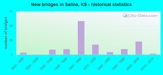
- New bridges - historical statistics
- 41920-1929
- 11930-1939
- 91940-1949
- 101950-1959
- 591960-1969
- 181970-1979
- 51980-1989
- 101990-1999
- 232000-2009
- 22010-2019
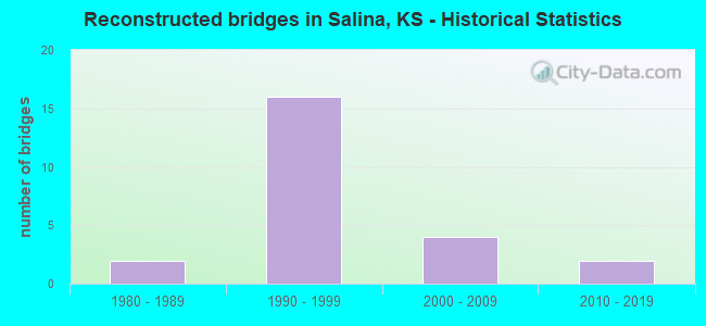
- Reconstructed bridges - Historical Statistics
- 21980-1989
- 161990-1999
- 42000-2009
- 22010-2019
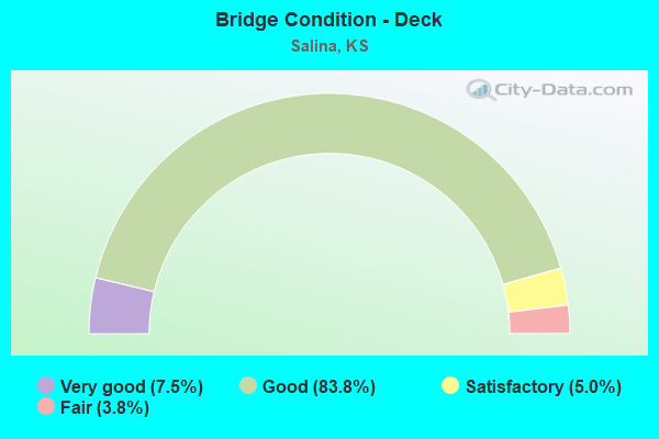
- Bridge Condition - Deck
- 7.5%Very good
- 83.8%Good
- 5.0%Satisfactory
- 3.8%Fair
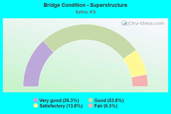
- Bridge Condition - Superstructure
- 26.3%Very good
- 53.8%Good
- 13.8%Satisfactory
- 6.3%Fair
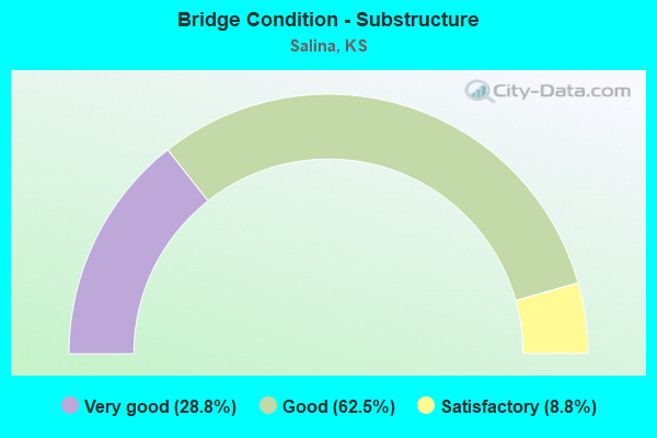
- Bridge Condition - Substructure
- 28.8%Very good
- 62.5%Good
- 8.8%Satisfactory
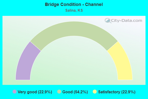
- Bridge Condition - Channel
- 22.9%Very good
- 54.2%Good
- 22.9%Satisfactory
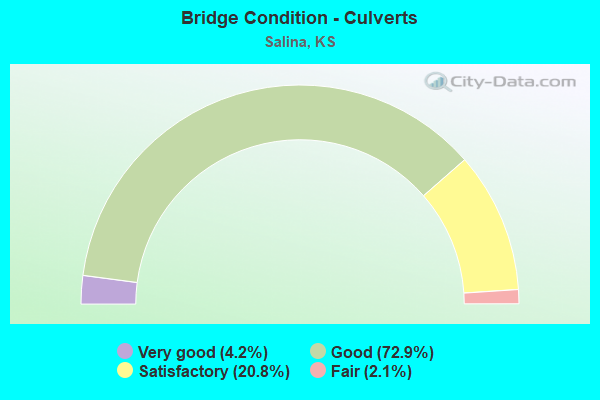
- Bridge Condition - Culverts
- 4.2%Very good
- 72.9%Good
- 20.8%Satisfactory
- 2.1%Fair
Find on map >> Show street view
Structure Number: 999914300851041, Location: 2.62 MI N I70, SDRD EAST (Lat: 38.914167, Lng: -97.611667), Route carried "on" structure: County highway 523, Year Built: 1948, Status: Open, Structure Length: 2.27m (7.45ft), Average Daily Traffic: 825 (year 2020), Average Future Daily Traffic: 3,389 (year 2041), Design Load: H 15, Features Intersected: SALINE RIVER DRAINAGE, Facility Carried by Structure: SHIPTON RD. 100W
Minimum Vertical Clearance: 30.47m (99.97ft), Kilometerpoint: 4.545, Lanes on structure: 2, Owner: State Highway Agency, Approaching Roadway Width: 7.3m (24.0ft), Material/Design: Concrete continuous, Design/Construction: Slab, Number Of Spans In Main Unit: 3, Length of Maximum Span: 8.5m (27.9ft), Curb-To-Curb Width: 7.3m (24.0ft), Out-to-Out Width: 7.8m (25.6ft)
Condition: Deck: Fair, Superstructure: Good, Substructure: Good, Channel: Good, Operating Rating: 47.2 metric tons, Method Used To Determine Operating Rating: Load Factor (LF), Inventory Rating: 28.1 metric tons, Method Used To Determine Inventory Rating: Load Factor (LF), Structural Evaluation: Better than present minimum criteria, Deck Geometry: Meets minimum limits, Waterway Adequacy: Equal to present minimum criteria, Approach Roadway Alignment: Somewhat better than minimum adequacy, Length Of Structure Improvement: 7.45m (24.44ft), Designated Inspection Frequency: Every 24 months, Inspection Date: May 2020, Deck Structure Type: Concrete Cast-file-Place, Wearing Surface/Protective System: Wearing Surface: Monolithic Concrete
Find on map >> Show street view
Structure Number: 999914300851051, Location: 0.82 MI E US81 (Lat: 38.922500, Lng: -97.630556), Route carried "on" structure: State highway 143, Year Built: 1969, Status: Open, Structure Length: 0.73m (2.40ft), Average Daily Traffic: 2,810 (year 2020), Truck Traffic: 8%, Average Future Daily Traffic: 3,567 (year 2041), Design Load: H 20, Features Intersected: SALINE RIVER DRAINAGE
Minimum Vertical Clearance: 30.47m (99.97ft), Kilometerpoint: 6.716, Lanes on structure: 2, Owner: State Highway Agency, Approaching Roadway Width: 9.1m (29.9ft), Skew: 3 degrees, Material/Design: Concrete, Design/Construction: Culvert, Number Of Spans In Main Unit: 2, Length of Maximum Span: 3.0m (9.8ft), Curb-To-Curb Width: 13.4m (44.0ft), Out-to-Out Width: 30.0m (98.4ft)
Condition: Channel: Good, Culverts: Good, Operating Rating: 48.1 metric tons, Method Used To Determine Operating Rating: Load Factor (LF), Inventory Rating: 29.0 metric tons, Method Used To Determine Inventory Rating: Load Factor (LF), Structural Evaluation: Better than present minimum criteria, Deck Geometry: Better than present minimum criteria, Waterway Adequacy: Better than present minimum criteria, Approach Roadway Alignment: Better than present minimum criteria, Length Of Structure Improvement: 2.39m (7.84ft), Designated Inspection Frequency: Every 24 months, Inspection Date: May 2020, Deck Structure Type: Concrete Cast-file-Place, Wearing Surface/Protective System: Wearing Surface: Bituminous
Find on map >> Show street view
Structure Number: 999914300851671, Location: 0.50 MI N I70 (Lat: 38.883611, Lng: -97.612222), Route carried "on" structure: State highway 143, Year Built: 2014, Status: Open, Structure Length: 1.33m (4.36ft), Average Daily Traffic: 5,110 (year 2020), Truck Traffic: 5%, Average Future Daily Traffic: 6,487 (year 2041), Design Load: HL 93, Features Intersected: MULBERRY CREEK DRAINAGE
Minimum Vertical Clearance: 30.47m (99.97ft), Kilometerpoint: 1.310, Lanes on structure: 5, Owner: State Highway Agency, Approaching Roadway Width: 25.6m (84.0ft), Material/Design: Concrete, Design/Construction: Culvert, Number Of Spans In Main Unit: 3, Length of Maximum Span: 4.3m (14.1ft), Curb-To-Curb Width: 25.6m (84.0ft), Out-to-Out Width: 37.5m (123.0ft)
Condition: Channel: Very good, Culverts: Very good, Operating Rating: 58.0 metric tons, Method Used To Determine Operating Rating: Load and Resistance Factor Rating (LRFR) rating reported by rating factor(RF) method using HL-93 loadings, Inventory Rating: 44.7 metric tons, Method Used To Determine Inventory Rating: Load and Resistance Factor Rating (LRFR) rating reported by rating factor(RF) method using HL-93 loadings, Structural Evaluation: Equal to present desirable criteria, Deck Geometry: Superior to present desirable criteria, Waterway Adequacy: Equal to present desirable criteria, Approach Roadway Alignment: Equal to present desirable criteria, Length Of Structure Improvement: 4.37m (14.34ft), Designated Inspection Frequency: Every 24 months, Inspection Date: May 2020, Wearing Surface/Protective System: Wearing Surface: Bituminous, Deck Protection: Epoxy Coated Reinforcing
Find on map >> Show street view
Structure Number: 999907000850561, Location: 14.07 MI E LINCOLN COLN (Lat: 38.876944, Lng: -97.668056), Route carried "under" structure: Interstate 70, Year Built: 1964, Structure Length: 0. m, Average Daily Traffic: 9,562 (year 2020), Truck Traffic: 28%, Features Intersected: I70 HWY, EB/WB, Facility Carried by Structure: RS1710
Minimum Vertical Clearance: 5.11m (16.77ft), Kilometerpoint: 22.632, Lanes on structure: 2, Lanes under structure: 4, Material/Design: Concrete continuous, Design/Construction: Box Beam or Girders - Multiple, Length of Maximum Span: 21.3m (69.9ft)
Find on map >> Show street view
Structure Number: 999907000851621, Location: 1.10 MI E K143 HWY (Lat: 38.881667, Lng: -97.594167), Route carried "under" structure: Interstate 70, Year Built: 2004, Structure Length: 0. m, Average Daily Traffic: 8,904 (year 2020), Truck Traffic: 21%, Features Intersected: I70 HWY, EB/WB, Facility Carried by Structure: RS1778, OHIO ST.
Minimum Vertical Clearance: 5.09m (16.70ft), Kilometerpoint: 29.229, Lanes on structure: 2, Lanes under structure: 4, Material/Design: Steel continuous, Design/Construction: Stringer/Multi-beam, Length of Maximum Span: 32.5m (106.6ft)
Find on map >> Show street view
Structure Number: 999913500850121, Location: 3.03 MI N NJCT K4 (Lat: 38.725278, Lng: -97.620278), Route carried "under" structure: Interstate 135, Year Built: 1966, Structure Length: 0. m, Average Daily Traffic: 7,690 (year 2020), Truck Traffic: 25%, Features Intersected: I135HWY WL-EL, Facility Carried by Structure: LOCAL ROAD
Minimum Vertical Clearance: 4.97m (16.31ft), Kilometerpoint: 12.944, Lanes on structure: 2, Lanes under structure: 4, Material/Design: Concrete continuous, Design/Construction: Box Beam or Girders - Multiple, Length of Maximum Span: 22.6m (74.1ft)
Find on map >> Show street view
Structure Number: 999913500850151, Location: JCT K104/I135, SB (Lat: 38.740000, Lng: -97.618056), Route carried "under" structure: State highway 104, Year Built: 1966, Structure Length: 0. m, Average Daily Traffic: 860 (year 2020), Truck Traffic: 13%, Features Intersected: RS0593 LT, K104 HWY RT, Facility Carried by Structure: I135 US81, SB
Minimum Vertical Clearance: 4.77m (15.65ft), Kilometerpoint: 0.095, Lanes on structure: 2, Lanes under structure: 2, Material/Design: Concrete continuous, Design/Construction: Slab, Length of Maximum Span: 13.7m (44.9ft)
Find on map >> Show street view
Structure Number: 999913500850161, Location: JCT K104/I135, NB (Lat: 38.740000, Lng: -97.617778), Route carried "under" structure: State highway 104, Year Built: 1966, Structure Length: 0. m, Average Daily Traffic: 860 (year 2020), Truck Traffic: 13%, Features Intersected: RS0593 LT, K104 HWY RT, Facility Carried by Structure: I135 US81, NB
Minimum Vertical Clearance: 4.67m (15.32ft), Kilometerpoint: 0.069, Lanes on structure: 2, Lanes under structure: 2, Material/Design: Concrete continuous, Design/Construction: Slab, Length of Maximum Span: 13.7m (44.9ft)
Find on map >> Show street view
Structure Number: 999913500850171, Location: 1.00 MI N K104 (Lat: 38.754444, Lng: -97.618056), Route carried "under" structure: Interstate 135, Year Built: 1963, Structure Length: 0. m, Average Daily Traffic: 7,994 (year 2020), Truck Traffic: 25%, Features Intersected: I135 HWY WL-EL, Facility Carried by Structure: LOCAL ROAD
Minimum Vertical Clearance: 5.08m (16.67ft), Kilometerpoint: 16.200, Lanes on structure: 2, Lanes under structure: 4, Material/Design: Concrete continuous, Design/Construction: Box Beam or Girders - Multiple, Length of Maximum Span: 20.7m (67.9ft)
Find on map >> Show street view
Structure Number: 999913500850271, Location: 2.35MI N MAGNOLIA ST (Lat: 38.826944, Lng: -97.639722), Route carried "under" structure: Interstate 135, Year Built: 1963, Structure Length: 0. m, Average Daily Traffic: 10,776 (year 2020), Truck Traffic: 21%, Features Intersected: I135 HWY WL-EL, Facility Carried by Structure: URB4816, CRWFRD
Minimum Vertical Clearance: 5.06m (16.60ft), Kilometerpoint: 24.848, Lanes on structure: 4, Lanes under structure: 4, Material/Design: Concrete continuous, Design/Construction: Slab, Length of Maximum Span: 21.6m (70.9ft)
Find on map >> Show street view
Structure Number: 999913500850301, Location: JCT K140/I135 SB (Lat: 38.841389, Lng: -97.646389), Route carried "under" structure: State highway 140, Year Built: 1963, Structure Length: 0. m, Average Daily Traffic: 1,140 (year 2020), Truck Traffic: 14%, Features Intersected: K140 HIGHWAY, Facility Carried by Structure: I135 HWY SB
Minimum Vertical Clearance: 4.59m (15.06ft), Kilometerpoint: 26.937, Lanes on structure: 2, Lanes under structure: 6, Material/Design: Concrete continuous, Design/Construction: Slab, Length of Maximum Span: 13.8m (45.3ft)
Find on map >> Show street view
Structure Number: 999913500850311, Location: JCT K140/I135, NB (Lat: 38.841389, Lng: -97.646111), Route carried "under" structure: State highway 140, Year Built: 1963, Structure Length: 0. m, Average Daily Traffic: 1,140 (year 2020), Truck Traffic: 14%, Features Intersected: K140 HIGHWAY, Facility Carried by Structure: I135 HWY NB
Minimum Vertical Clearance: 4.55m (14.93ft), Kilometerpoint: 26.963, Lanes on structure: 2, Lanes under structure: 6, Material/Design: Concrete continuous, Design/Construction: Slab, Length of Maximum Span: 13.8m (45.3ft)
Find on map >> Show street view
Structure Number: 999913500850391, Location: JCT I70/I135, SB (Lat: 38.874444, Lng: -97.645556), Route carried "under" structure: Interstate 70, Year Built: 1963, Structure Length: 0. m, Average Daily Traffic: 8,651 (year 2020), Truck Traffic: 30%, Features Intersected: I70 HIGHWAY, Facility Carried by Structure: I135 HWY SB
Minimum Vertical Clearance: 5.03m (16.50ft), Kilometerpoint: 24.618, Lanes on structure: 3, Lanes under structure: 6, Material/Design: Concrete continuous, Design/Construction: Box Beam or Girders - Multiple, Length of Maximum Span: 23.2m (76.1ft)
Find on map >> Show street view
Structure Number: 999913500850401, Location: JCT I70/I135, NB (Lat: 38.874444, Lng: -97.645000), Route carried "under" structure: Interstate 70, Year Built: 1970, Structure Length: 0. m, Average Daily Traffic: 8,651 (year 2020), Truck Traffic: 30%, Features Intersected: I70 HIGHWAY, Facility Carried by Structure: I135 HWY NB
Minimum Vertical Clearance: 5.11m (16.77ft), Kilometerpoint: 24.649, Lanes on structure: 3, Lanes under structure: 6, Material/Design: Steel continuous, Design/Construction: Stringer/Multi-beam, Length of Maximum Span: 23.2m (76.1ft)
Find on map >> Show street view
Structure Number: 999913500851501, Location: 2.08 MI N OF K-104 (Lat: 38.768611, Lng: -97.617778), Route carried "under" structure: Interstate 135, Year Built: 1990, Structure Length: 0. m, Average Daily Traffic: 7,994 (year 2020), Truck Traffic: 25%, Features Intersected: I-135 HWY WL-EL, Facility Carried by Structure: WATERWELL ROAD
Minimum Vertical Clearance: 4.97m (16.31ft), Kilometerpoint: 17.790, Lanes on structure: 2, Lanes under structure: 4, Material/Design: Prestressed concrete continuous, Design/Construction: Stringer/Multi-beam, Length of Maximum Span: 33.7m (110.6ft)
Find on map >> Show street view
Structure Number: 999913500851511, Location: I-135/MAGNOLIA INTERCNG (Lat: 38.798056, Lng: -97.618333), Route carried "under" structure: Interstate 135, Year Built: 1998, Structure Length: 0. m, Average Daily Traffic: 10,727 (year 2020), Truck Traffic: 20%, Features Intersected: I-135 HWY, Facility Carried by Structure: Magnolia St.
Minimum Vertical Clearance: 4.98m (16.34ft), Kilometerpoint: 21.063, Lanes on structure: 2, Lanes under structure: 4, Material/Design: Steel continuous, Design/Construction: Stringer/Multi-beam, Length of Maximum Span: 28.7m (94.2ft)