Bridge Statistics for Sandston, Virginia (VA)
Condition, Traffic, Stress, Structural Evaluation, Project Costs
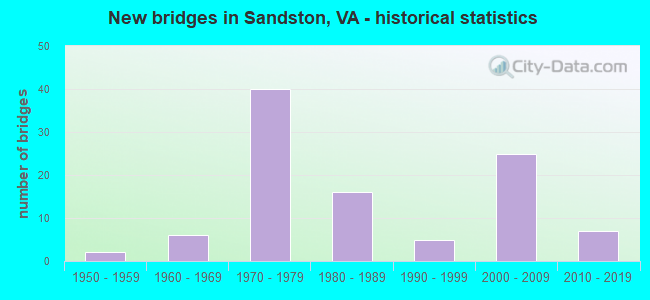
- New bridges - historical statistics
- 21950-1959
- 61960-1969
- 401970-1979
- 161980-1989
- 51990-1999
- 252000-2009
- 72010-2019
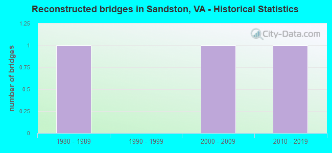
- Reconstructed bridges - Historical Statistics
- 11980-1989
- 01990-1999
- 12000-2009
- 12010-2019
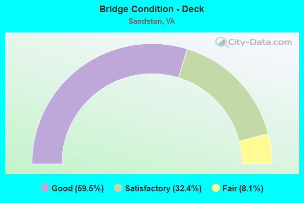
- Bridge Condition - Deck
- 59.5%Good
- 32.4%Satisfactory
- 8.1%Fair
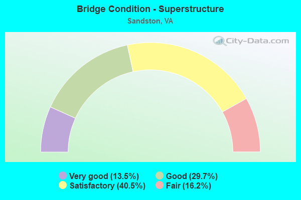
- Bridge Condition - Superstructure
- 13.5%Very good
- 29.7%Good
- 40.5%Satisfactory
- 16.2%Fair
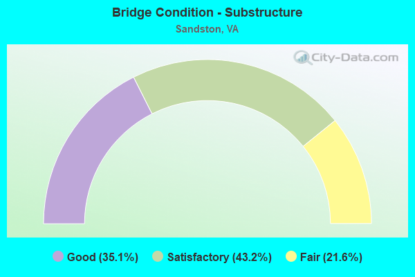
- Bridge Condition - Substructure
- 35.1%Good
- 43.2%Satisfactory
- 21.6%Fair
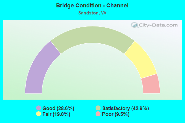
- Bridge Condition - Channel
- 28.6%Good
- 42.9%Satisfactory
- 19.0%Fair
- 9.5%Poor
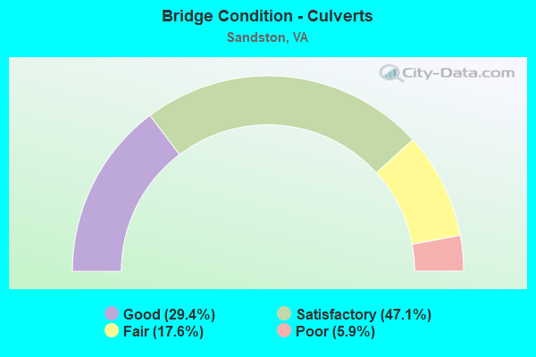
- Bridge Condition - Culverts
- 29.4%Good
- 47.1%Satisfactory
- 17.6%Fair
- 5.9%Poor
Find on map >> Show street view
Structure Number: 962, Location: .2 WILMSBG & .2 DRYBR CT (Lat: 37.523006, Lng: -77.281175), Route carried "on" structure: County highway 7589, Year Built: 1979, Status: Open, Structure Length: 14.07m (46.16ft), Average Daily Traffic: 490 (year 2020), Truck Traffic: 8%, Average Future Daily Traffic: 541 (year 2040), Design Load: HS 20+Mod, Features Intersected: RTE I 64, Facility Carried by Structure: DRY BRIDGE ROAD
Minimum Vertical Clearance: 30+ m (98+ ft), Kilometerpoint: 1.315, Lanes on structure: 2, Lanes under structure: 8, Owner: State Highway Agency, Approaching Roadway Width: 11.0m (36.1ft), Material/Design: Steel continuous, Design/Construction: Stringer/Multi-beam, Number Of Spans In Main Unit: 4, Length of Maximum Span: 36.3m (119.1ft), Curb-To-Curb Width: 10.4m (34.1ft), Out-to-Out Width: 11.6m (38.1ft)
Condition: Deck: Satisfactory, Superstructure: Fair, Substructure: Satisfactory, Operating Rating: 75.3 metric tons, Method Used To Determine Operating Rating: Load and Resistance Factor (LRFR), Inventory Rating: 58.1 metric tons, Method Used To Determine Inventory Rating: Load and Resistance Factor (LRFR), Structural Evaluation: Somewhat better than minimum adequacy, Deck Geometry: Equal to present minimum criteria, Underclear: Equal to present minimum criteria, Approach Roadway Alignment: Equal to present desirable criteria, Designated Inspection Frequency: Every 24 months, Inspection Date: January 2022, Deck Structure Type: Concrete Cast-file-Place, Wearing Surface/Protective System: Deck Protection: Epoxy Coated Reinforcing
Find on map >> Show street view
Structure Number: 9628, Location: 0.60FINLAY ST0.30HOLLY AV (Lat: 37.531028, Lng: -77.344661), Route carried "on" structure: County highway 7607, Year Built: 1964, Status: Open, Structure Length: 8.56m (28.08ft), Average Daily Traffic: 9,014 (year 2020), Truck Traffic: 2%, Average Future Daily Traffic: 11,055 (year 2040), Design Load: HS 20, Features Intersected: I-64, Facility Carried by Structure: OAKLEYS LANE
Minimum Vertical Clearance: 30+ m (98+ ft), Kilometerpoint: 1.718, Lanes on structure: 2, Lanes under structure: 6, Owner: State Highway Agency, Approaching Roadway Width: 9.1m (29.9ft), Material/Design: Steel, Design/Construction: Stringer/Multi-beam, Number Of Spans In Main Unit: 4, Length of Maximum Span: 25.0m (82.0ft), Curb or Sidewalk Widths: Left: 0.5m (1.6ft), Right: 0.5m (1.6ft), Curb-To-Curb Width: 8.5m (27.9ft), Out-to-Out Width: 10.1m (33.1ft)
Condition: Deck: Fair, Superstructure: Fair, Substructure: Satisfactory, Operating Rating: 55.3 metric tons, Method Used To Determine Operating Rating: Load and Resistance Factor (LRFR), Inventory Rating: 42.6 metric tons, Method Used To Determine Inventory Rating: Load and Resistance Factor (LRFR), Structural Evaluation: Somewhat better than minimum adequacy, Deck Geometry: Meets minimum limits, Underclear: Somewhat better than minimum adequacy, Approach Roadway Alignment: Equal to present desirable criteria, Designated Inspection Frequency: Every 24 months, Inspection Date: May 2020, Deck Structure Type: Concrete Cast-file-Place
Find on map >> Show street view
Structure Number: 9645, Location: 0010STRWHLL0015VAR CH RD (Lat: 37.456831, Lng: -77.309442), Route carried "on" structure: County highway 75590, Year Built: 1986, Status: Open, Structure Length: 0.64m (2.10ft), Average Daily Traffic: 2,589 (year 2020), Truck Traffic: 3%, Average Future Daily Traffic: 2,848 (year 2040), Design Load: HS 20+Mod, Features Intersected: DEERLICK CREEK, Facility Carried by Structure: DARBYTOWN ROAD
Minimum Vertical Clearance: 30+ m (98+ ft), Kilometerpoint: 10.185, Lanes on structure: 2, Owner: County Highway Agency, Approaching Roadway Width: 7.3m (24.0ft), Material/Design: Concrete, Design/Construction: Culvert, Number Of Spans In Main Unit: 2, Length of Maximum Span: 3.0m (9.8ft)
Condition: Channel: Satisfactory, Culverts: Satisfactory, Operating Rating: 54.4 metric tons, Method Used To Determine Operating Rating: Load Factor (LF), Inventory Rating: 32.7 metric tons, Method Used To Determine Inventory Rating: Load Factor (LF), Structural Evaluation: Equal to present minimum criteria, Waterway Adequacy: Equal to present desirable criteria, Approach Roadway Alignment: Equal to present desirable criteria, Designated Inspection Frequency: Every 24 months, Inspection Date: July 2021
Find on map >> Show street view
Structure Number: 965, Location: .7 LA FRA RD .3 POP SP RD (Lat: 37.488444, Lng: -77.270022), Route carried "on" structure: County highway , Year Built: 1955, Status: Open, Structure Length: 0.85m (2.79ft), Average Daily Traffic: 1,631 (year 2011), Truck Traffic: 10%, Average Future Daily Traffic: 2,500 (year 2025), Design Load: HS 20, Features Intersected: WHITE OAK CREEK, Facility Carried by Structure: PORTUGEE ROAD
Minimum Vertical Clearance: 30+ m (98+ ft), Kilometerpoint: 0.000, Lanes on structure: 2, Owner: County Highway Agency, Approaching Roadway Width: 7.3m (24.0ft), Material/Design: Concrete, Design/Construction: Culvert, Number Of Spans In Main Unit: 3, Length of Maximum Span: 2.7m (8.9ft), Curb-To-Curb Width: 10.9m (35.8ft), Out-to-Out Width: 11.6m (38.1ft)
Condition: Channel: Good, Culverts: Fair, Operating Rating: 55.9 metric tons, Method Used To Determine Operating Rating: Load Factor (LF), Inventory Rating: 38.1 metric tons, Method Used To Determine Inventory Rating: Load Factor (LF), Structural Evaluation: Somewhat better than minimum adequacy, Deck Geometry: Equal to present minimum criteria, Waterway Adequacy: Better than present minimum criteria, Approach Roadway Alignment: Equal to present desirable criteria, Designated Inspection Frequency: Every 24 months, Inspection Date: August 2020, Deck Structure Type: Concrete Cast-file-Place, Wearing Surface/Protective System: Wearing Surface: Bituminous
Find on map >> Show street view
Structure Number: 9651, Location: .5 60 .67 OLD OAKLEY'S LN (Lat: 37.525786, Lng: -77.343583), Route carried "on" structure: County highway , Year Built: 1963, Status: Open, Structure Length: 1.16m (3.81ft), Average Daily Traffic: 9,014 (year 2020), Truck Traffic: 2%, Average Future Daily Traffic: 11,055 (year 2040), Design Load: HS 20, Features Intersected: GILLIES CREEK, Facility Carried by Structure: OAKLEY'S LANE
Minimum Vertical Clearance: 30+ m (98+ ft), Kilometerpoint: 0.805, Lanes on structure: 3, Owner: County Highway Agency, Approaching Roadway Width: 14.6m (47.9ft), Material/Design: Concrete, Design/Construction: Culvert, Number Of Spans In Main Unit: 4, Length of Maximum Span: 2.4m (7.9ft), Curb-To-Curb Width: 14.6m (47.9ft), Out-to-Out Width: 15.2m (49.9ft)
Condition: Channel: Good, Culverts: Satisfactory, Operating Rating: 39.6 metric tons, Method Used To Determine Operating Rating: Load Factor (LF), Inventory Rating: 23.4 metric tons, Method Used To Determine Inventory Rating: Load Factor (LF), Structural Evaluation: Somewhat better than minimum adequacy, Deck Geometry: Somewhat better than minimum adequacy, Waterway Adequacy: Equal to present minimum criteria, Approach Roadway Alignment: Equal to present desirable criteria, Designated Inspection Frequency: Every 24 months, Inspection Date: August 2020, Deck Structure Type: Concrete Cast-file-Place, Wearing Surface/Protective System: Wearing Surface: Bituminous
Find on map >> Show street view
Structure Number: 9652, Location: 2.40 GRAPEVINE RD 0.40 60 (Lat: 37.519639, Lng: -77.238342), Route carried "on" structure: County highway , Year Built: 1954, Status: Open, Structure Length: 0.70m (2.30ft), Average Daily Traffic: 570 (year 2020), Truck Traffic: 2%, Average Future Daily Traffic: 670 (year 2038), Design Load: HS 20, Features Intersected: BOAR SWAMP, Facility Carried by Structure: MEADOW ROAD
Minimum Vertical Clearance: 30+ m (98+ ft), Kilometerpoint: 0.000, Lanes on structure: 2, Owner: County Highway Agency, Approaching Roadway Width: 7.3m (24.0ft), Material/Design: Concrete, Design/Construction: Culvert, Number Of Spans In Main Unit: 2, Length of Maximum Span: 3.0m (9.8ft)
Condition: Channel: Poor, Culverts: Poor, Operating Rating: 49.0 metric tons, Method Used To Determine Operating Rating: Load Factor (LF), Inventory Rating: 29.0 metric tons, Method Used To Determine Inventory Rating: Load Factor (LF), Structural Evaluation: Meets minimum limits, Waterway Adequacy: Equal to present minimum criteria, Approach Roadway Alignment: Somewhat better than minimum adequacy, Length Of Structure Improvement: 0.64m (2.10ft), Designated Inspection Frequency: Every 12 months, Inspection Date: August 2021, Bridge Improvement Cost: $80,000, Roadway Improvement Cost: $18,000, Total Project Cost: $109,000
Find on map >> Show street view
Structure Number: 9672, Location: 0.2 DRYBRGE & 0.2 GRPEVIN (Lat: 37.529875, Lng: -77.274658), Route carried "on" structure: County highway 7628, Year Built: 1978, Status: Open, Structure Length: 22.37m (73.39ft), Average Daily Traffic: 566 (year 2020), Truck Traffic: 4%, Average Future Daily Traffic: 792 (year 2040), Design Load: HS 20+Mod, Features Intersected: ROUTE I-295, Facility Carried by Structure: MEADOW ROAD
Minimum Vertical Clearance: 30+ m (98+ ft), Kilometerpoint: 3.202, Lanes on structure: 2, Lanes under structure: 11, Owner: State Highway Agency, Approaching Roadway Width: 11.3m (37.1ft), Skew: 4 degrees, Material/Design: Steel continuous, Design/Construction: Stringer/Multi-beam, Number Of Spans In Main Unit: 4, Length of Maximum Span: 60.4m (198.2ft), Curb-To-Curb Width: 10.4m (34.1ft), Out-to-Out Width: 11.6m (38.1ft)
Condition: Deck: Fair, Superstructure: Satisfactory, Substructure: Satisfactory, Inventory Rating: 79.8 metric tons, Method Used To Determine Inventory Rating: Load and Resistance Factor (LRFR), Structural Evaluation: Equal to present minimum criteria, Deck Geometry: Equal to present minimum criteria, Underclear: Somewhat better than minimum adequacy, Approach Roadway Alignment: Equal to present desirable criteria, Designated Inspection Frequency: Every 24 months, Inspection Date: October 2021, Deck Structure Type: Concrete Cast-file-Place, Wearing Surface/Protective System: Deck Protection: Epoxy Coated Reinforcing
Find on map >> Show street view
Structure Number: 9681, Location: 0.26WILLBG RD0.36MEADOW R (Lat: 37.524725, Lng: -77.280414), Route carried "on" structure: County highway 7589, Year Built: 1979, Status: Open, Structure Length: 4.09m (13.42ft), Average Daily Traffic: 492 (year 2020), Truck Traffic: 6%, Average Future Daily Traffic: 541 (year 2040), Design Load: HS 20+Mod, Features Intersected: NS RAILWAY, Facility Carried by Structure: DRY BRIDGE ROAD
Minimum Vertical Clearance: 30+ m (98+ ft), Kilometerpoint: 1.392, Lanes on structure: 2, Owner: State Highway Agency, Approaching Roadway Width: 11.0m (36.1ft), Material/Design: Steel continuous, Design/Construction: Stringer/Multi-beam, Number Of Spans In Main Unit: 3, Length of Maximum Span: 15.8m (51.8ft), Curb-To-Curb Width: 10.4m (34.1ft), Out-to-Out Width: 11.6m (38.1ft)
Condition: Deck: Satisfactory, Superstructure: Satisfactory, Substructure: Satisfactory, Operating Rating: 77.1 metric tons, Method Used To Determine Operating Rating: Load and Resistance Factor (LRFR), Inventory Rating: 59.0 metric tons, Method Used To Determine Inventory Rating: Load and Resistance Factor (LRFR), Structural Evaluation: Equal to present minimum criteria, Deck Geometry: Equal to present minimum criteria, Underclear: Somewhat better than minimum adequacy, Approach Roadway Alignment: Equal to present desirable criteria, Designated Inspection Frequency: Every 24 months, Inspection Date: October 2021, Deck Structure Type: Concrete Cast-file-Place, Wearing Surface/Protective System: Deck Protection: Epoxy Coated Reinforcing
Find on map >> Show street view
Structure Number: 9707, Location: 0.43BEULAH RD0.05TURNER R (Lat: 37.477169, Lng: -77.304794), Route carried "on" structure: County highway 7723, Year Built: 1987, Status: Open, Structure Length: 7.99m (26.21ft), Average Daily Traffic: 729 (year 2020), Truck Traffic: 13%, Average Future Daily Traffic: 1,021 (year 2040), Design Load: HS 20+Mod, Features Intersected: I-295, Facility Carried by Structure: CHARLES CITY ROAD
Minimum Vertical Clearance: 30+ m (98+ ft), Kilometerpoint: 8.302, Lanes on structure: 2, Lanes under structure: 8, Owner: State Highway Agency, Approaching Roadway Width: 11.7m (38.4ft), Material/Design: Steel continuous, Design/Construction: Stringer/Multi-beam, Number Of Spans In Main Unit: 2, Length of Maximum Span: 39.4m (129.3ft), Curb-To-Curb Width: 11.7m (38.4ft), Out-to-Out Width: 12.7m (41.7ft)
Condition: Deck: Good, Superstructure: Satisfactory, Substructure: Fair, Operating Rating: 52.5 metric tons, Method Used To Determine Operating Rating: Load and Resistance Factor (LRFR), Inventory Rating: 40.5 metric tons, Method Used To Determine Inventory Rating: Load and Resistance Factor (LRFR), Structural Evaluation: Somewhat better than minimum adequacy, Deck Geometry: Better than present minimum criteria, Underclear: Equal to present minimum criteria, Approach Roadway Alignment: Equal to present desirable criteria, Designated Inspection Frequency: Every 24 months, Inspection Date: May 2020, Deck Structure Type: Concrete Cast-file-Place, Wearing Surface/Protective System: Deck Protection: Epoxy Coated Reinforcing
Find on map >> Show street view
Structure Number: 9748, Location: 0.9 WHTSDE RD & 1.98 156 (Lat: 37.510333, Lng: -77.275800), Route carried "on" structure: US 60, Year Built: 1979, Status: Open, Structure Length: 23.53m (77.20ft), Average Daily Traffic: 14,006 (year 2020), Truck Traffic: 5%, Average Future Daily Traffic: 19,610 (year 2040), Design Load: HS 20+Mod, Features Intersected: RTE I 295, Facility Carried by Structure: WBL WILLIAMSBURG
Minimum Vertical Clearance: 30+ m (98+ ft), Kilometerpoint: 322.724, Lanes on structure: 3, Lanes under structure: 12, Owner: State Highway Agency, Approaching Roadway Width: 16.5m (54.1ft), Material/Design: Steel, Design/Construction: Stringer/Multi-beam, Number Of Spans In Main Unit: 1, Number Of Approach Spans: 6, Length of Maximum Span: 37.2m (122.0ft), Curb-To-Curb Width: 15.8m (51.8ft), Out-to-Out Width: 17.1m (56.1ft)
Condition: Deck: Satisfactory, Superstructure: Fair, Substructure: Fair, Operating Rating: 59.9 metric tons, Method Used To Determine Operating Rating: Load and Resistance Factor (LRFR), Inventory Rating: 45.4 metric tons, Method Used To Determine Inventory Rating: Load and Resistance Factor (LRFR), Structural Evaluation: Somewhat better than minimum adequacy, Deck Geometry: Better than present minimum criteria, Underclear: Somewhat better than minimum adequacy, Approach Roadway Alignment: Equal to present desirable criteria, Designated Inspection Frequency: Every 24 months, Inspection Date: October 2021, Deck Structure Type: Concrete Cast-file-Place, Wearing Surface/Protective System: Deck Protection: Epoxy Coated Reinforcing
Find on map >> Show street view
Structure Number: 975, Location: 0.7 DRYBRGE & 1.6 MT.ZION (Lat: 37.510181, Lng: -77.275906), Route carried "on" structure: US 60, Year Built: 1979, Status: Open, Structure Length: 23.44m (76.90ft), Average Daily Traffic: 14,006 (year 2020), Truck Traffic: 5%, Average Future Daily Traffic: 19,610 (year 2040), Design Load: HS 20, Features Intersected: RTE I 295, Facility Carried by Structure: EBL WILLIAMSBURG
Minimum Vertical Clearance: 5.66m (18.57ft), Kilometerpoint: 322.725, Lanes on structure: 3, Lanes under structure: 12, Base Highway Network: Yes, Owner: State Highway Agency, Approaching Roadway Width: 16.5m (54.1ft), Material/Design: Steel, Design/Construction: Stringer/Multi-beam, Number Of Spans In Main Unit: 1, Number Of Approach Spans: 6, Length of Maximum Span: 36.9m (121.1ft), Curb-To-Curb Width: 15.8m (51.8ft), Out-to-Out Width: 17.1m (56.1ft)
Condition: Deck: Fair, Superstructure: Fair, Substructure: Satisfactory, Operating Rating: 58.6 metric tons, Method Used To Determine Operating Rating: Load and Resistance Factor (LRFR), Inventory Rating: 45.2 metric tons, Method Used To Determine Inventory Rating: Load and Resistance Factor (LRFR), Structural Evaluation: Somewhat better than minimum adequacy, Deck Geometry: Better than present minimum criteria, Underclear: Equal to present desirable criteria, Approach Roadway Alignment: Equal to present desirable criteria, Length Of Structure Improvement: 23.44m (76.90ft), Designated Inspection Frequency: Every 24 months, Inspection Date: October 2021, Bridge Improvement Cost: $250,000, Roadway Improvement Cost: $75,000, Total Project Cost: $330,000, Deck Structure Type: Concrete Cast-file-Place, Wearing Surface/Protective System: Deck Protection: Epoxy Coated Reinforcing
Find on map >> Show street view
Structure Number: 977, Location: 0.75 LABRNM & 1.23 TO 156 (Lat: 37.532125, Lng: -77.349336), Route carried "on" structure: Interstate 64, Year Built: 1965, Status: Open, Structure Length: 1.46m (4.79ft), Average Daily Traffic: 21,119 (year 2020), Truck Traffic: 4%, Average Future Daily Traffic: 29,567 (year 2040), Design Load: HS 20, Features Intersected: GILLIES CREEK
Minimum Vertical Clearance: 30+ m (98+ ft), Kilometerpoint: 316.474, Lanes on structure: 3, Base Highway Network: Yes, Owner: State Highway Agency, Approaching Roadway Width: 17.1m (56.1ft), Skew: 4 degrees, Material/Design: Concrete, Design/Construction: Culvert, Number Of Spans In Main Unit: 4, Length of Maximum Span: 3.4m (11.2ft)
Condition: Channel: Fair, Culverts: Satisfactory, Operating Rating: 72.1 metric tons, Method Used To Determine Operating Rating: Load and Resistance Factor (LRFR), Inventory Rating: 55.6 metric tons, Method Used To Determine Inventory Rating: Load and Resistance Factor (LRFR), Structural Evaluation: Equal to present minimum criteria, Waterway Adequacy: Equal to present desirable criteria, Approach Roadway Alignment: Equal to present desirable criteria, Designated Inspection Frequency: Every 24 months, Inspection Date: October 2021
Find on map >> Show street view
Structure Number: 9771, Location: 0.76 LABRNM & 1.21 TO 156 (Lat: 37.531825, Lng: -77.349022), Route carried "on" structure: Interstate 64, Year Built: 1965, Status: Open, Structure Length: 1.46m (4.79ft), Average Daily Traffic: 21,526 (year 2020), Truck Traffic: 4%, Average Future Daily Traffic: 30,136 (year 2040), Design Load: HS 20, Features Intersected: GILLIES CREEK
Minimum Vertical Clearance: 30+ m (98+ ft), Kilometerpoint: 316.506, Lanes on structure: 3, Base Highway Network: Yes, Owner: State Highway Agency, Approaching Roadway Width: 17.1m (56.1ft), Skew: 4 degrees, Material/Design: Concrete, Design/Construction: Culvert, Number Of Spans In Main Unit: 4, Length of Maximum Span: 3.4m (11.2ft)
Condition: Channel: Fair, Culverts: Satisfactory, Operating Rating: 54.4 metric tons, Method Used To Determine Operating Rating: Field evaluation and documented engineering judgment, Inventory Rating: 32.7 metric tons, Method Used To Determine Inventory Rating: Field evaluation and documented engineering judgment, Structural Evaluation: Equal to present minimum criteria, Waterway Adequacy: Equal to present minimum criteria, Approach Roadway Alignment: Equal to present desirable criteria, Designated Inspection Frequency: Every 24 months, Inspection Date: October 2021
Find on map >> Show street view
Structure Number: 9812, Location: 0.2564 WB CR 0.25295 WB C (Lat: 37.522561, Lng: -77.267806), Route carried "on" structure: Ramp Interstate 64, Year Built: 1979, Year Reconstructed: 1992, Status: Open, Structure Length: 5.84m (19.16ft), Average Daily Traffic: 10,969 (year 2020), Truck Traffic: 17%, Average Future Daily Traffic: 15,357 (year 2040), Design Load: HS 20+Mod, Features Intersected: SOUTHERN RAILWAY
Minimum Vertical Clearance: 30+ m (98+ ft), Kilometerpoint: 0.402, Lanes on structure: 2, Base Highway Network: Yes, Owner: State Highway Agency, Approaching Roadway Width: 12.8m (42.0ft), Skew: 4 degrees, Material/Design: Steel, Design/Construction: Stringer/Multi-beam, Number Of Spans In Main Unit: 3, Length of Maximum Span: 19.6m (64.3ft), Curb-To-Curb Width: 11.9m (39.0ft), Out-to-Out Width: 12.9m (42.3ft)
Condition: Deck: Good, Superstructure: Satisfactory, Substructure: Satisfactory, Operating Rating: 96.8 metric tons, Method Used To Determine Operating Rating: Load and Resistance Factor (LRFR), Inventory Rating: 74.5 metric tons, Method Used To Determine Inventory Rating: Load and Resistance Factor (LRFR), Structural Evaluation: Equal to present minimum criteria, Deck Geometry: Superior to present desirable criteria, Underclear: Better than present minimum criteria, Approach Roadway Alignment: Equal to present desirable criteria, Designated Inspection Frequency: Every 24 months, Inspection Date: October 2020, Deck Structure Type: Concrete Cast-file-Place, Wearing Surface/Protective System: Deck Protection: Epoxy Coated Reinforcing
Find on map >> Show street view
Structure Number: 9814, Location: .33 64W CD & .16 295W CD (Lat: 37.523803, Lng: -77.268850), Route carried "on" structure: Ramp Interstate 64, Year Built: 1979, Status: Open, Structure Length: 0.67m (2.20ft), Average Daily Traffic: 10,969 (year 2020), Truck Traffic: 17%, Average Future Daily Traffic: 15,357 (year 2040), Design Load: HS 20+Mod, Features Intersected: STREAM
Minimum Vertical Clearance: 30+ m (98+ ft), Kilometerpoint: 0.531, Lanes on structure: 2, Base Highway Network: Yes, Owner: State Highway Agency, Approaching Roadway Width: 9.1m (29.9ft), Skew: 4 degrees, Material/Design: Concrete, Design/Construction: Culvert, Number Of Spans In Main Unit: 2, Length of Maximum Span: 3.2m (10.5ft)
Condition: Channel: Poor, Culverts: Fair, Operating Rating: 54.4 metric tons, Method Used To Determine Operating Rating: Field evaluation and documented engineering judgment, Inventory Rating: 32.7 metric tons, Method Used To Determine Inventory Rating: Field evaluation and documented engineering judgment, Structural Evaluation: Somewhat better than minimum adequacy, Waterway Adequacy: Equal to present desirable criteria, Approach Roadway Alignment: Equal to present desirable criteria, Designated Inspection Frequency: Every 24 months, Inspection Date: December 2021
Find on map >> Show street view
Structure Number: 99, Location: 2.12 FR 156 & .84 TO 33 (Lat: 37.521736, Lng: -77.270586), Route carried "on" structure: Interstate 295, Year Built: 1979, Status: Open, Structure Length: 15.65m (51.35ft), Average Daily Traffic: 10,894 (year 2020), Truck Traffic: 12%, Average Future Daily Traffic: 15,252 (year 2040), Design Load: HS 20+Mod, Features Intersected: RTE I 64 & CD RD
Minimum Vertical Clearance: 30+ m (98+ ft), Kilometerpoint: 38.864, Lanes on structure: 3, Lanes under structure: 10, Base Highway Network: Yes, Owner: State Highway Agency, Approaching Roadway Width: 18.3m (60.0ft), Skew: 1 degrees, Material/Design: Steel, Design/Construction: Stringer/Multi-beam, Number Of Spans In Main Unit: 4, Length of Maximum Span: 37.8m (124.0ft), Curb-To-Curb Width: 17.7m (58.1ft), Out-to-Out Width: 18.9m (62.0ft)
Condition: Deck: Good, Superstructure: Good, Substructure: Satisfactory, Operating Rating: 89.8 metric tons, Method Used To Determine Operating Rating: Load and Resistance Factor (LRFR), Inventory Rating: 80.7 metric tons, Method Used To Determine Inventory Rating: Load and Resistance Factor (LRFR), Structural Evaluation: Equal to present minimum criteria, Deck Geometry: Better than present minimum criteria, Underclear: Equal to present minimum criteria, Approach Roadway Alignment: Equal to present desirable criteria, Designated Inspection Frequency: Every 24 months, Inspection Date: November 2021, Deck Structure Type: Concrete Cast-file-Place, Wearing Surface/Protective System: Deck Protection: Epoxy Coated Reinforcing
Find on map >> Show street view
Structure Number: 9902, Location: .86 MEADOW RD & .54 TO 60 (Lat: 37.521900, Lng: -77.271161), Route carried "on" structure: Interstate 295, Year Built: 1979, Status: Open, Structure Length: 15.65m (51.35ft), Average Daily Traffic: 10,389 (year 2020), Truck Traffic: 25%, Average Future Daily Traffic: 14,545 (year 2040), Design Load: HS 20+Mod, Features Intersected: RTE I 64 & CD RDS
Minimum Vertical Clearance: 30+ m (98+ ft), Kilometerpoint: 38.880, Lanes on structure: 3, Lanes under structure: 10, Base Highway Network: Yes, Owner: State Highway Agency, Approaching Roadway Width: 18.3m (60.0ft), Skew: 1 degrees, Material/Design: Steel, Design/Construction: Stringer/Multi-beam, Number Of Spans In Main Unit: 4, Length of Maximum Span: 37.8m (124.0ft), Curb-To-Curb Width: 17.7m (58.1ft), Out-to-Out Width: 18.9m (62.0ft)
Condition: Deck: Good, Superstructure: Good, Substructure: Satisfactory, Operating Rating: 76.0 metric tons, Method Used To Determine Operating Rating: Load and Resistance Factor (LRFR), Inventory Rating: 58.6 metric tons, Method Used To Determine Inventory Rating: Load and Resistance Factor (LRFR), Structural Evaluation: Equal to present minimum criteria, Deck Geometry: Better than present minimum criteria, Underclear: Equal to present minimum criteria, Approach Roadway Alignment: Equal to present desirable criteria, Designated Inspection Frequency: Every 24 months, Inspection Date: November 2021, Deck Structure Type: Concrete Cast-file-Place, Wearing Surface/Protective System: Deck Protection: Epoxy Coated Reinforcing
Find on map >> Show street view
Structure Number: 9904, Location: 2.12 FR 156 & 0.84 TO 33 (Lat: 37.521628, Lng: -77.269956), Route carried "on" structure: Ramp Interstate 295, Year Built: 1979, Status: Open, Structure Length: 15.65m (51.35ft), Average Daily Traffic: 8,331 (year 2020), Truck Traffic: 11%, Average Future Daily Traffic: 9,164 (year 2040), Design Load: HS 20+Mod, Features Intersected: RTE I-64 & CD RDS
Minimum Vertical Clearance: 15.85m (52.00ft), Kilometerpoint: 2.285, Lanes on structure: 3, Lanes under structure: 10, Base Highway Network: Yes, Owner: State Highway Agency, Approaching Roadway Width: 16.5m (54.1ft), Skew: 1 degrees, Material/Design: Steel, Design/Construction: Stringer/Multi-beam, Number Of Spans In Main Unit: 4, Length of Maximum Span: 37.8m (124.0ft), Curb-To-Curb Width: 16.1m (52.8ft), Out-to-Out Width: 17.1m (56.1ft)
Condition: Deck: Satisfactory, Superstructure: Satisfactory, Substructure: Fair, Operating Rating: 99.6 metric tons, Method Used To Determine Operating Rating: Load and Resistance Factor (LRFR), Inventory Rating: 76.8 metric tons, Method Used To Determine Inventory Rating: Load and Resistance Factor (LRFR), Structural Evaluation: Somewhat better than minimum adequacy, Deck Geometry: Superior to present desirable criteria, Underclear: Equal to present minimum criteria, Approach Roadway Alignment: Equal to present desirable criteria, Designated Inspection Frequency: Every 24 months, Inspection Date: November 2021, Deck Structure Type: Concrete Cast-file-Place, Wearing Surface/Protective System: Deck Protection: Epoxy Coated Reinforcing
Find on map >> Show street view
Structure Number: 9906, Location: 2.11 FR 156 & 0.9 TO 33 (Lat: 37.522103, Lng: -77.271886), Route carried "on" structure: Ramp Interstate 295, Year Built: 1979, Status: Open, Structure Length: 15.65m (51.35ft), Average Daily Traffic: 7,319 (year 2020), Truck Traffic: 18%, Average Future Daily Traffic: 8,051 (year 2040), Design Load: HS 20+Mod, Features Intersected: RTE I 64 & CD RDS
Minimum Vertical Clearance: 30+ m (98+ ft), Kilometerpoint: 1.706, Lanes on structure: 3, Lanes under structure: 10, Base Highway Network: Yes, Owner: State Highway Agency, Approaching Roadway Width: 16.5m (54.1ft), Skew: 1 degrees, Material/Design: Steel, Design/Construction: Stringer/Multi-beam, Number Of Spans In Main Unit: 4, Length of Maximum Span: 37.8m (124.0ft), Curb-To-Curb Width: 15.8m (51.8ft), Out-to-Out Width: 17.1m (56.1ft)
Condition: Deck: Satisfactory, Superstructure: Satisfactory, Substructure: Fair, Operating Rating: 97.3 metric tons, Method Used To Determine Operating Rating: Load and Resistance Factor (LRFR), Inventory Rating: 75.0 metric tons, Method Used To Determine Inventory Rating: Load and Resistance Factor (LRFR), Structural Evaluation: Somewhat better than minimum adequacy, Deck Geometry: Superior to present desirable criteria, Underclear: Better than present minimum criteria, Approach Roadway Alignment: Equal to present desirable criteria, Designated Inspection Frequency: Every 24 months, Inspection Date: November 2021, Deck Structure Type: Concrete Cast-file-Place, Wearing Surface/Protective System: Deck Protection: Epoxy Coated Reinforcing
Find on map >> Show street view
Structure Number: 9908, Location: 2.0 FR 156 & 0.16 TO I-64 (Lat: 37.523469, Lng: -77.270783), Route carried "on" structure: Interstate 295, Year Built: 1979, Status: Open, Structure Length: 4.65m (15.26ft), Average Daily Traffic: 10,894 (year 2020), Truck Traffic: 11%, Average Future Daily Traffic: 15,252 (year 2040), Design Load: HS 20+Mod, Features Intersected: NS RAILWAY
Minimum Vertical Clearance: 30+ m (98+ ft), Kilometerpoint: 38.449, Lanes on structure: 3, Base Highway Network: Yes, Owner: State Highway Agency, Approaching Roadway Width: 17.8m (58.4ft), Skew: 1 degrees, Material/Design: Steel, Design/Construction: Stringer/Multi-beam, Number Of Spans In Main Unit: 3, Length of Maximum Span: 16.8m (55.1ft), Curb-To-Curb Width: 17.8m (58.4ft), Out-to-Out Width: 18.8m (61.7ft)
Condition: Deck: Satisfactory, Superstructure: Fair, Substructure: Fair, Operating Rating: 90.6 metric tons, Method Used To Determine Operating Rating: Load and Resistance Factor (LRFR), Inventory Rating: 72.6 metric tons, Method Used To Determine Inventory Rating: Load and Resistance Factor (LRFR), Structural Evaluation: Somewhat better than minimum adequacy, Deck Geometry: Better than present minimum criteria, Underclear: Equal to present minimum criteria, Approach Roadway Alignment: Equal to present desirable criteria, Designated Inspection Frequency: Every 24 months, Inspection Date: October 2021, Deck Structure Type: Concrete Cast-file-Place, Wearing Surface/Protective System: Deck Protection: Epoxy Coated Reinforcing
Find on map >> Show street view
Structure Number: 9909, Location: 2.0 FR 156 & 0.16 TO I-64 (Lat: 37.523544, Lng: -77.271339), Route carried "on" structure: Interstate 295, Year Built: 1979, Status: Open, Structure Length: 4.65m (15.26ft), Average Daily Traffic: 10,389 (year 2020), Truck Traffic: 11%, Average Future Daily Traffic: 14,545 (year 2040), Design Load: HS 20+Mod, Features Intersected: NS RAILWAY
Minimum Vertical Clearance: 30+ m (98+ ft), Kilometerpoint: 38.449, Lanes on structure: 3, Base Highway Network: Yes, Owner: State Highway Agency, Approaching Roadway Width: 18.3m (60.0ft), Skew: 1 degrees, Material/Design: Steel, Design/Construction: Stringer/Multi-beam, Number Of Spans In Main Unit: 3, Length of Maximum Span: 16.2m (53.1ft), Curb-To-Curb Width: 17.8m (58.4ft), Out-to-Out Width: 18.8m (61.7ft)
Condition: Deck: Good, Superstructure: Satisfactory, Substructure: Fair, Operating Rating: 96.2 metric tons, Method Used To Determine Operating Rating: Load and Resistance Factor (LRFR), Inventory Rating: 73.5 metric tons, Method Used To Determine Inventory Rating: Load and Resistance Factor (LRFR), Structural Evaluation: Somewhat better than minimum adequacy, Deck Geometry: Better than present minimum criteria, Underclear: Equal to present minimum criteria, Approach Roadway Alignment: Equal to present desirable criteria, Designated Inspection Frequency: Every 24 months, Inspection Date: October 2021, Deck Structure Type: Concrete Cast-file-Place, Wearing Surface/Protective System: Deck Protection: Epoxy Coated Reinforcing
Find on map >> Show street view
Structure Number: 991, Location: 2.0 Fr 156 & .16 I-64 (Lat: 37.523344, Lng: -77.270072), Route carried "on" structure: Ramp Interstate 295, Year Built: 1979, Status: Open, Structure Length: 4.57m (14.99ft), Average Daily Traffic: 3,800 (year 2020), Truck Traffic: 11%, Average Future Daily Traffic: 6,468 (year 2040), Design Load: HS 20+Mod, Features Intersected: NS RAILWAY
Minimum Vertical Clearance: 30+ m (98+ ft), Kilometerpoint: 2.494, Lanes on structure: 2, Base Highway Network: Yes, Owner: State Highway Agency, Approaching Roadway Width: 13.1m (43.0ft), Skew: 1 degrees, Material/Design: Steel, Design/Construction: Stringer/Multi-beam, Number Of Spans In Main Unit: 3, Length of Maximum Span: 16.2m (53.1ft), Curb-To-Curb Width: 12.3m (40.4ft), Out-to-Out Width: 13.4m (44.0ft)
Condition: Deck: Good, Superstructure: Satisfactory, Substructure: Fair, Operating Rating: 89.9 metric tons, Method Used To Determine Operating Rating: Load and Resistance Factor (LRFR), Inventory Rating: 69.1 metric tons, Method Used To Determine Inventory Rating: Load and Resistance Factor (LRFR), Structural Evaluation: Somewhat better than minimum adequacy, Deck Geometry: Superior to present desirable criteria, Underclear: Somewhat better than minimum adequacy, Approach Roadway Alignment: Equal to present desirable criteria, Designated Inspection Frequency: Every 24 months, Inspection Date: November 2021, Deck Structure Type: Concrete Cast-file-Place, Wearing Surface/Protective System: Deck Protection: Epoxy Coated Reinforcing
Find on map >> Show street view
Structure Number: 9911, Location: 2.0 156 & .16 I-64 (Lat: 37.523678, Lng: -77.272050), Route carried "on" structure: Ramp Interstate 295, Year Built: 1979, Status: Open, Structure Length: 4.27m (14.01ft), Average Daily Traffic: 3,775 (year 2020), Truck Traffic: 10%, Average Future Daily Traffic: 5,285 (year 2040), Design Load: HS 20+Mod, Features Intersected: NS RAILWAY
Minimum Vertical Clearance: 30+ m (98+ ft), Kilometerpoint: 1.448, Lanes on structure: 2, Base Highway Network: Yes, Owner: State Highway Agency, Approaching Roadway Width: 12.8m (42.0ft), Skew: 1 degrees, Material/Design: Steel, Design/Construction: Stringer/Multi-beam, Number Of Spans In Main Unit: 3, Length of Maximum Span: 14.7m (48.2ft), Curb-To-Curb Width: 12.3m (40.4ft), Out-to-Out Width: 13.4m (44.0ft)
Condition: Deck: Satisfactory, Superstructure: Fair, Substructure: Fair, Operating Rating: 89.8 metric tons, Method Used To Determine Operating Rating: Load and Resistance Factor (LRFR), Inventory Rating: 69.1 metric tons, Method Used To Determine Inventory Rating: Load and Resistance Factor (LRFR), Structural Evaluation: Somewhat better than minimum adequacy, Deck Geometry: Superior to present desirable criteria, Underclear: Somewhat better than minimum adequacy, Approach Roadway Alignment: Equal to present desirable criteria, Designated Inspection Frequency: Every 24 months, Inspection Date: November 2021, Deck Structure Type: Concrete Cast-file-Place, Wearing Surface/Protective System: Deck Protection: Epoxy Coated Reinforcing
Find on map >> Show street view
Structure Number: 9912, Location: 0.20295 SB CR0.2064 WB CR (Lat: 37.523956, Lng: -77.273739), Route carried "on" structure: Ramp Interstate 295, Year Built: 1979, Status: Open, Structure Length: 5.03m (16.50ft), Average Daily Traffic: 307 (year 2020), Truck Traffic: 11%, Average Future Daily Traffic: 430 (year 2040), Design Load: HS 20+Mod, Features Intersected: NS RAILWAY
Minimum Vertical Clearance: 30+ m (98+ ft), Kilometerpoint: 0.241, Lanes on structure: 1, Base Highway Network: Yes, Owner: State Highway Agency, Approaching Roadway Width: 8.8m (28.9ft), Skew: 3 degrees, Material/Design: Steel, Design/Construction: Stringer/Multi-beam, Number Of Spans In Main Unit: 3, Length of Maximum Span: 18.0m (59.1ft), Curb-To-Curb Width: 8.7m (28.5ft), Out-to-Out Width: 9.7m (31.8ft)
Condition: Deck: Good, Superstructure: Satisfactory, Substructure: Satisfactory, Operating Rating: 63.2 metric tons, Method Used To Determine Operating Rating: Load and Resistance Factor (LRFR), Inventory Rating: 48.8 metric tons, Method Used To Determine Inventory Rating: Load and Resistance Factor (LRFR), Structural Evaluation: Equal to present minimum criteria, Deck Geometry: Superior to present desirable criteria, Underclear: Somewhat better than minimum adequacy, Approach Roadway Alignment: Equal to present desirable criteria, Designated Inspection Frequency: Every 24 months, Inspection Date: October 2021, Deck Structure Type: Concrete Cast-file-Place, Wearing Surface/Protective System: Deck Protection: Epoxy Coated Reinforcing
Find on map >> Show street view
Structure Number: 9975, Location: 0.72 TO 60 & 5.29 TO 5 (Lat: 37.501622, Lng: -77.282675), Route carried "on" structure: Interstate 295, Year Built: 1987, Status: Open, Structure Length: 10.35m (33.96ft), Average Daily Traffic: 17,767 (year 2020), Truck Traffic: 24%, Average Future Daily Traffic: 24,874 (year 2040), Design Load: HS 20+Mod, Features Intersected: WHITE OAK SWAMP CREEK
Minimum Vertical Clearance: 30+ m (98+ ft), Kilometerpoint: 41.062, Lanes on structure: 5, Base Highway Network: Yes, Owner: State Highway Agency, Approaching Roadway Width: 25.1m (82.3ft), Material/Design: Prestressed concrete, Design/Construction: Stringer/Multi-beam, Number Of Spans In Main Unit: 6, Length of Maximum Span: 16.5m (54.1ft), Curb-To-Curb Width: 25.1m (82.3ft), Out-to-Out Width: 26.2m (86.0ft)
Condition: Deck: Satisfactory, Superstructure: Satisfactory, Substructure: Satisfactory, Channel: Satisfactory, Operating Rating: 99.8 metric tons, Method Used To Determine Operating Rating: Load and Resistance Factor (LRFR), Inventory Rating: 66.2 metric tons, Method Used To Determine Inventory Rating: Load and Resistance Factor (LRFR), Structural Evaluation: Equal to present minimum criteria, Deck Geometry: Better than present minimum criteria, Waterway Adequacy: Equal to present desirable criteria, Approach Roadway Alignment: Equal to present desirable criteria, Designated Inspection Frequency: Every 24 months, Inspection Date: September 2020, Deck Structure Type: Concrete Cast-file-Place, Wearing Surface/Protective System: Deck Protection: Epoxy Coated Reinforcing
Find on map >> Show street view
Structure Number: 9976, Location: 0.72 TO 60 & 05.29 TO 5 (Lat: 37.501431, Lng: -77.282406), Route carried "on" structure: Interstate 295, Year Built: 1987, Status: Open, Structure Length: 10.35m (33.96ft), Average Daily Traffic: 10,894 (year 2020), Truck Traffic: 22%, Average Future Daily Traffic: 15,252 (year 2040), Design Load: HS 20+Mod, Features Intersected: WHITE OAK SWAMP CREEK
Minimum Vertical Clearance: 30+ m (98+ ft), Kilometerpoint: 41.062, Lanes on structure: 4, Base Highway Network: Yes, Owner: State Highway Agency, Approaching Roadway Width: 21.5m (70.5ft), Material/Design: Prestressed concrete, Design/Construction: Stringer/Multi-beam, Number Of Spans In Main Unit: 6, Length of Maximum Span: 16.5m (54.1ft), Curb-To-Curb Width: 21.5m (70.5ft), Out-to-Out Width: 22.5m (73.8ft)
Condition: Deck: Satisfactory, Superstructure: Satisfactory, Substructure: Satisfactory, Channel: Fair, Operating Rating: 78.9 metric tons, Method Used To Determine Operating Rating: Load and Resistance Factor (LRFR), Inventory Rating: 51.7 metric tons, Method Used To Determine Inventory Rating: Load and Resistance Factor (LRFR), Structural Evaluation: Equal to present minimum criteria, Deck Geometry: Better than present minimum criteria, Waterway Adequacy: Equal to present desirable criteria, Approach Roadway Alignment: Equal to present desirable criteria, Designated Inspection Frequency: Every 24 months, Inspection Date: September 2020, Deck Structure Type: Concrete Cast-file-Place, Wearing Surface/Protective System: Deck Protection: Epoxy Coated Reinforcing
Find on map >> Show street view
Structure Number: 9977, Location: 1.75 TO 60 & 4.26 FR 5 (Lat: 37.490236, Lng: -77.294650), Route carried "on" structure: Interstate 295, Year Built: 1987, Status: Open, Structure Length: 6.21m (20.37ft), Average Daily Traffic: 17,767 (year 2020), Truck Traffic: 24%, Average Future Daily Traffic: 24,874 (year 2040), Design Load: HS 20+Mod, Features Intersected: PORTUGEE ROAD
Minimum Vertical Clearance: 30+ m (98+ ft), Kilometerpoint: 42.719, Lanes on structure: 3, Lanes under structure: 2, Base Highway Network: Yes, Owner: State Highway Agency, Approaching Roadway Width: 18.6m (61.0ft), Skew: 3 degrees, Material/Design: Steel, Design/Construction: Stringer/Multi-beam, Number Of Spans In Main Unit: 3, Length of Maximum Span: 31.8m (104.3ft), Curb-To-Curb Width: 17.8m (58.4ft), Out-to-Out Width: 18.8m (61.7ft)
Condition: Deck: Satisfactory, Superstructure: Good, Substructure: Satisfactory, Operating Rating: 52.6 metric tons, Method Used To Determine Operating Rating: Load and Resistance Factor (LRFR), Inventory Rating: 40.8 metric tons, Method Used To Determine Inventory Rating: Load and Resistance Factor (LRFR), Structural Evaluation: Equal to present minimum criteria, Deck Geometry: Better than present minimum criteria, Underclear: Superior to present desirable criteria, Approach Roadway Alignment: Equal to present desirable criteria, Designated Inspection Frequency: Every 24 months, Inspection Date: September 2020, Deck Structure Type: Concrete Cast-file-Place, Wearing Surface/Protective System: Deck Protection: Epoxy Coated Reinforcing
Find on map >> Show street view
Structure Number: 9979, Location: 1.75 TO 60 & 4.26 FR 5 (Lat: 37.490211, Lng: -77.294242), Route carried "on" structure: Interstate 295, Year Built: 1987, Status: Open, Structure Length: 6.21m (20.37ft), Average Daily Traffic: 18,176 (year 2020), Truck Traffic: 22%, Average Future Daily Traffic: 25,446 (year 2040), Design Load: HS 20+Mod, Features Intersected: PORTUGEE ROAD
Minimum Vertical Clearance: 30+ m (98+ ft), Kilometerpoint: 42.719, Lanes on structure: 3, Lanes under structure: 2, Base Highway Network: Yes, Owner: State Highway Agency, Approaching Roadway Width: 18.6m (61.0ft), Skew: 3 degrees, Material/Design: Steel, Design/Construction: Stringer/Multi-beam, Number Of Spans In Main Unit: 3, Length of Maximum Span: 31.8m (104.3ft), Curb-To-Curb Width: 17.8m (58.4ft), Out-to-Out Width: 18.8m (61.7ft)
Condition: Deck: Good, Superstructure: Good, Substructure: Satisfactory, Operating Rating: 73.5 metric tons, Method Used To Determine Operating Rating: Load and Resistance Factor (LRFR), Inventory Rating: 56.2 metric tons, Method Used To Determine Inventory Rating: Load and Resistance Factor (LRFR), Structural Evaluation: Equal to present minimum criteria, Deck Geometry: Better than present minimum criteria, Underclear: Superior to present desirable criteria, Approach Roadway Alignment: Equal to present desirable criteria, Designated Inspection Frequency: Every 24 months, Inspection Date: September 2020, Deck Structure Type: Concrete Cast-file-Place, Wearing Surface/Protective System: Deck Protection: Epoxy Coated Reinforcing
Find on map >> Show street view
Structure Number: 9981, Location: 01.88 TO 60 & 4.13 FR 5 (Lat: 37.488775, Lng: -77.296039), Route carried "on" structure: Interstate 295, Year Built: 1987, Status: Open, Structure Length: 4.94m (16.21ft), Average Daily Traffic: 17,767 (year 2020), Truck Traffic: 22%, Average Future Daily Traffic: 24,874 (year 2040), Design Load: HS 20+Mod, Features Intersected: CSX TRANSPORTATION
Minimum Vertical Clearance: 30+ m (98+ ft), Kilometerpoint: 42.928, Lanes on structure: 3, Base Highway Network: Yes, Owner: State Highway Agency, Approaching Roadway Width: 18.6m (61.0ft), Skew: 2 degrees, Material/Design: Steel, Design/Construction: Stringer/Multi-beam, Number Of Spans In Main Unit: 3, Length of Maximum Span: 23.2m (76.1ft), Curb-To-Curb Width: 17.8m (58.4ft), Out-to-Out Width: 18.8m (61.7ft)
Condition: Deck: Good, Superstructure: Satisfactory, Substructure: Satisfactory, Operating Rating: 78.7 metric tons, Method Used To Determine Operating Rating: Load and Resistance Factor (LRFR), Inventory Rating: 60.8 metric tons, Method Used To Determine Inventory Rating: Load and Resistance Factor (LRFR), Structural Evaluation: Equal to present minimum criteria, Deck Geometry: Better than present minimum criteria, Underclear: Equal to present minimum criteria, Approach Roadway Alignment: Equal to present desirable criteria, Designated Inspection Frequency: Every 24 months, Inspection Date: September 2020, Deck Structure Type: Concrete Cast-file-Place, Wearing Surface/Protective System: Deck Protection: Epoxy Coated Reinforcing
Find on map >> Show street view
Structure Number: 9984, Location: 3.65 FR 5 & 2.36 TO 60 (Lat: 37.482739, Lng: -77.300553), Route carried "on" structure: Interstate 295, Year Built: 1987, Status: Open, Structure Length: 6.92m (22.70ft), Average Daily Traffic: 18,176 (year 2020), Truck Traffic: 22%, Average Future Daily Traffic: 25,446 (year 2040), Design Load: HS 20+Mod, Features Intersected: WHITE OAK SWAMP CREEK
Minimum Vertical Clearance: 30+ m (98+ ft), Kilometerpoint: 43.700, Lanes on structure: 3, Base Highway Network: Yes, Owner: State Highway Agency, Approaching Roadway Width: 18.6m (61.0ft), Material/Design: Prestressed concrete, Design/Construction: Stringer/Multi-beam, Number Of Spans In Main Unit: 4, Length of Maximum Span: 16.5m (54.1ft), Curb-To-Curb Width: 17.8m (58.4ft), Out-to-Out Width: 18.8m (61.7ft)
Condition: Deck: Satisfactory, Superstructure: Satisfactory, Substructure: Satisfactory, Channel: Good, Inventory Rating: 61.7 metric tons, Method Used To Determine Inventory Rating: Load and Resistance Factor (LRFR), Structural Evaluation: Equal to present minimum criteria, Deck Geometry: Better than present minimum criteria, Waterway Adequacy: Equal to present desirable criteria, Approach Roadway Alignment: Equal to present desirable criteria, Designated Inspection Frequency: Every 24 months, Inspection Date: September 2020, Deck Structure Type: Concrete Cast-file-Place, Wearing Surface/Protective System: Deck Protection: Epoxy Coated Reinforcing
Find on map >> Show street view
Structure Number: 9987, Location: 4.13 TO 60 & 1.88 TO 5 (Lat: 37.459639, Lng: -77.314394), Route carried "on" structure: Interstate 295, Year Built: 1987, Status: Open, Structure Length: 3.78m (12.40ft), Average Daily Traffic: 15,617 (year 2020), Truck Traffic: 22%, Average Future Daily Traffic: 21,864 (year 2040), Design Load: HS 20+Mod, Features Intersected: DARBYTOWN ROAD
Minimum Vertical Clearance: 30+ m (98+ ft), Kilometerpoint: 46.548, Lanes on structure: 3, Lanes under structure: 2, Base Highway Network: Yes, Owner: State Highway Agency, Approaching Roadway Width: 18.6m (61.0ft), Material/Design: Steel, Design/Construction: Stringer/Multi-beam, Number Of Spans In Main Unit: 1, Length of Maximum Span: 36.6m (120.1ft), Curb-To-Curb Width: 17.8m (58.4ft), Out-to-Out Width: 18.8m (61.7ft)
Condition: Deck: Good, Superstructure: Satisfactory, Substructure: Satisfactory, Inventory Rating: 69.9 metric tons, Method Used To Determine Inventory Rating: Load and Resistance Factor (LRFR), Structural Evaluation: Equal to present minimum criteria, Deck Geometry: Better than present minimum criteria, Underclear: Better than present minimum criteria, Approach Roadway Alignment: Equal to present desirable criteria, Designated Inspection Frequency: Every 24 months, Inspection Date: September 2020, Deck Structure Type: Concrete Precast Panels, Wearing Surface/Protective System: Deck Protection: Epoxy Coated Reinforcing
Find on map >> Show street view
Structure Number: 9989, Location: 5.10 TO 60 & 0.91 TO 5 (Lat: 37.448033, Lng: -77.324753), Route carried "on" structure: Interstate 295, Year Built: 1987, Status: Open, Structure Length: 7.86m (25.79ft), Average Daily Traffic: 15,564 (year 2020), Truck Traffic: 24%, Average Future Daily Traffic: 21,790 (year 2040), Design Load: HS 20+Mod, Features Intersected: FOURMILE CREEK
Minimum Vertical Clearance: 30+ m (98+ ft), Kilometerpoint: 48.109, Lanes on structure: 3, Base Highway Network: Yes, Owner: State Highway Agency, Approaching Roadway Width: 18.6m (61.0ft), Skew: 1 degrees, Material/Design: Prestressed concrete, Design/Construction: Stringer/Multi-beam, Number Of Spans In Main Unit: 4, Length of Maximum Span: 18.9m (62.0ft), Curb or Sidewalk Widths: Left: 0.2m (0.7ft), Right: 0.2m (0.7ft), Curb-To-Curb Width: 17.8m (58.4ft), Out-to-Out Width: 18.8m (61.7ft)
Condition: Deck: Good, Superstructure: Satisfactory, Substructure: Good, Channel: Good, Operating Rating: 89.8 metric tons, Method Used To Determine Operating Rating: Load and Resistance Factor (LRFR), Inventory Rating: 62.6 metric tons, Method Used To Determine Inventory Rating: Load and Resistance Factor (LRFR), Structural Evaluation: Equal to present minimum criteria, Deck Geometry: Better than present minimum criteria, Waterway Adequacy: Equal to present desirable criteria, Approach Roadway Alignment: Equal to present desirable criteria, Designated Inspection Frequency: Every 24 months, Inspection Date: August 2021, Deck Structure Type: Concrete Precast Panels, Wearing Surface/Protective System: Deck Protection: Epoxy Coated Reinforcing
Find on map >> Show street view
Structure Number: 23656, Location: 0010OAKLEY 0080AIRPORT DR (Lat: 37.525300, Lng: -77.342483), Route carried "on" structure: County highway 77160, Year Built: 1991, Status: Open, Structure Length: 1.70m (5.58ft), Average Daily Traffic: 8,974 (year 2020), Truck Traffic: 3%, Average Future Daily Traffic: 12,564 (year 2040), Design Load: HS 20, Features Intersected: GILLIES CREEK, Facility Carried by Structure: AUDUBON DRIVE
Minimum Vertical Clearance: 30+ m (98+ ft), Kilometerpoint: 0.000, Lanes on structure: 2, Owner: County Highway Agency, Approaching Roadway Width: 16.0m (52.5ft), Skew: 3 degrees, Material/Design: Concrete, Design/Construction: Culvert, Number Of Spans In Main Unit: 4, Length of Maximum Span: 3.0m (9.8ft)
Condition: Channel: Satisfactory, Culverts: Satisfactory, Operating Rating: 54.4 metric tons, Method Used To Determine Operating Rating: Load Factor (LF), Inventory Rating: 32.7 metric tons, Method Used To Determine Inventory Rating: Load Factor (LF), Structural Evaluation: Equal to present minimum criteria, Waterway Adequacy: Better than present minimum criteria, Approach Roadway Alignment: Equal to present desirable criteria, Designated Inspection Frequency: Every 24 months, Inspection Date: May 2021
Find on map >> Show street view
Structure Number: 23657, Location: 0040OAKLEY 0050AIRPORT DR (Lat: 37.525228, Lng: -77.337239), Route carried "on" structure: County highway 77160, Year Built: 1991, Status: Open, Structure Length: 1.28m (4.20ft), Average Daily Traffic: 8,974 (year 2020), Truck Traffic: 10%, Average Future Daily Traffic: 12,564 (year 2040), Design Load: HS 20, Features Intersected: GILLIES CREEK, Facility Carried by Structure: AUDUBON DRIVE
Minimum Vertical Clearance: 30+ m (98+ ft), Kilometerpoint: 0.000, Lanes on structure: 2, Owner: County Highway Agency, Approaching Roadway Width: 15.8m (51.8ft), Skew: 3 degrees, Material/Design: Concrete, Design/Construction: Culvert, Number Of Spans In Main Unit: 3, Length of Maximum Span: 3.0m (9.8ft)
Condition: Channel: Satisfactory, Culverts: Satisfactory, Operating Rating: 54.4 metric tons, Method Used To Determine Operating Rating: Load Factor (LF), Inventory Rating: 32.7 metric tons, Method Used To Determine Inventory Rating: Load Factor (LF), Structural Evaluation: Equal to present minimum criteria, Waterway Adequacy: Better than present minimum criteria, Approach Roadway Alignment: Equal to present desirable criteria, Designated Inspection Frequency: Every 24 months, Inspection Date: May 2021
Find on map >> Show street view
Structure Number: 23716, Location: .2 Ch Cty Rd .5 Drbytwn R (Lat: 37.498200, Lng: -77.350189), Route carried "on" structure: County highway 75553, Year Built: 1992, Status: Open, Structure Length: 5.76m (18.90ft), Average Daily Traffic: 20,320 (year 2020), Truck Traffic: 1%, Average Future Daily Traffic: 28,448 (year 2040), Design Load: HS 20, Features Intersected: CSX RAILWAY, Facility Carried by Structure: LABURNUM AVENUE
Minimum Vertical Clearance: 30+ m (98+ ft), Kilometerpoint: 4.907, Lanes on structure: 6, Base Highway Network: Yes, Owner: County Highway Agency, Approaching Roadway Width: 11.9m (39.0ft), Skew: 20 degrees, Material/Design: Steel continuous, Design/Construction: Stringer/Multi-beam, Number Of Spans In Main Unit: 3, Length of Maximum Span: 29.3m (96.1ft), Curb or Sidewalk Widths: Left: 1.5m (4.9ft), Right: 1.5m (4.9ft), Curb-To-Curb Width: 23.8m (78.1ft), Out-to-Out Width: 32.3m (106.0ft)
Condition: Deck: Good, Superstructure: Very good, Substructure: Good, Operating Rating: 59.0 metric tons, Method Used To Determine Operating Rating: Load and Resistance Factor (LRFR), Inventory Rating: 45.4 metric tons, Method Used To Determine Inventory Rating: Load and Resistance Factor (LRFR), Structural Evaluation: Better than present minimum criteria, Deck Geometry: Somewhat better than minimum adequacy, Underclear: Better than present minimum criteria, Approach Roadway Alignment: Equal to present desirable criteria, Designated Inspection Frequency: Every 24 months, Inspection Date: July 2021, Deck Structure Type: Concrete Cast-file-Place, Wearing Surface/Protective System: Wearing Surface: Monolithic Concrete
Find on map >> Show street view
Structure Number: 25642, Location: .24 FR 295S & 1.00 TO 64E (Lat: 37.523639, Lng: -77.271661), Route carried "on" structure: Ramp Interstate 295, Year Built: 2001, Status: Open, Structure Length: 5.00m (16.40ft), Average Daily Traffic: 11,307 (year 2020), Truck Traffic: 7%, Average Future Daily Traffic: 15,830 (year 2040), Design Load: HS 20+Mod, Features Intersected: NS RAILWAY
Minimum Vertical Clearance: 30+ m (98+ ft), Kilometerpoint: 0.000, Lanes on structure: 2, Base Highway Network: Yes, Owner: State Highway Agency, Approaching Roadway Width: 13.1m (43.0ft), Skew: 1 degrees, Material/Design: Steel continuous, Design/Construction: Stringer/Multi-beam, Number Of Spans In Main Unit: 3, Length of Maximum Span: 19.5m (64.0ft), Curb-To-Curb Width: 13.0m (42.7ft), Out-to-Out Width: 14.0m (45.9ft)
Condition: Deck: Good, Superstructure: Good, Substructure: Good, Operating Rating: 53.5 metric tons, Method Used To Determine Operating Rating: Load and Resistance Factor (LRFR), Inventory Rating: 41.3 metric tons, Method Used To Determine Inventory Rating: Load and Resistance Factor (LRFR), Structural Evaluation: Better than present minimum criteria, Deck Geometry: Superior to present desirable criteria, Underclear: Superior to present desirable criteria, Approach Roadway Alignment: Equal to present desirable criteria, Designated Inspection Frequency: Every 24 months, Inspection Date: October 2021, Deck Structure Type: Concrete Cast-file-Place, Wearing Surface/Protective System: Deck Protection: Epoxy Coated Reinforcing
Find on map >> Show street view
Structure Number: 25643, Location: .37 FR 295E & 0.87 TO 64E (Lat: 37.521981, Lng: -77.271611), Route carried "on" structure: Ramp Interstate 295, Year Built: 2001, Status: Open, Structure Length: 46.70m (153.22ft), Average Daily Traffic: 11,307 (year 2020), Truck Traffic: 17%, Average Future Daily Traffic: 15,830 (year 2040), Design Load: HS 20+Mod, Features Intersected: I- 64 AND I-295
Minimum Vertical Clearance: 30+ m (98+ ft), Kilometerpoint: 0.000, Lanes on structure: 2, Lanes under structure: 34, Base Highway Network: Yes, Owner: State Highway Agency, Approaching Roadway Width: 12.8m (42.0ft), Skew: 9 degrees, Material/Design: Steel continuous, Design/Construction: Stringer/Multi-beam, Number Of Spans In Main Unit: 12, Length of Maximum Span: 50.0m (164.0ft), Curb-To-Curb Width: 13.0m (42.7ft), Out-to-Out Width: 14.0m (45.9ft)
Condition: Deck: Satisfactory, Superstructure: Good, Substructure: Good, Operating Rating: 50.6 metric tons, Method Used To Determine Operating Rating: Load and Resistance Factor (LRFR), Inventory Rating: 38.8 metric tons, Method Used To Determine Inventory Rating: Load and Resistance Factor (LRFR), Structural Evaluation: Better than present minimum criteria, Deck Geometry: Superior to present desirable criteria, Underclear: Equal to present minimum criteria, Approach Roadway Alignment: Equal to present minimum criteria, Designated Inspection Frequency: Every 24 months, Critical Feature Inspection Frequency: Every 12 months, Inspection Date: May 2021, Critical Feature Inspection Date: May 2021, Deck Structure Type: Concrete Cast-file-Place, Wearing Surface/Protective System: Deck Protection: Epoxy Coated Reinforcing
Find on map >> Show street view
Structure Number: 27157, Location: 1.2 FR RTE. 5 (Lat: 37.471150, Lng: -77.362250), Route carried "on" structure: County highway , Year Built: 2002, Status: Open, Structure Length: 7.22m (23.69ft), Average Daily Traffic: 2,000 (year 2002), Truck Traffic: 1%, Average Future Daily Traffic: 3,080 (year 2032), Design Load: HS 20+Mod, Features Intersected: ROUTE 0895, Facility Carried by Structure: WILLSON ROAD
Minimum Vertical Clearance: 30+ m (98+ ft), Kilometerpoint: 0.000, Lanes on structure: 2, Lanes under structure: 4, Owner: State Highway Agency, Maintenance Responsibility: Private, Approaching Roadway Width: 11.9m (39.0ft), Material/Design: Steel continuous, Design/Construction: Stringer/Multi-beam, Number Of Spans In Main Unit: 2, Length of Maximum Span: 36.3m (119.1ft), Curb-To-Curb Width: 12.0m (39.4ft), Out-to-Out Width: 13.0m (42.7ft)
Condition: Deck: Good, Superstructure: Good, Substructure: Good, Operating Rating: 66.6 metric tons, Method Used To Determine Operating Rating: Load Factor (LF), Inventory Rating: 39.6 metric tons, Method Used To Determine Inventory Rating: Load Factor (LF), Structural Evaluation: Better than present minimum criteria, Deck Geometry: Equal to present minimum criteria, Underclear: Better than present minimum criteria, Approach Roadway Alignment: Equal to present desirable criteria, Designated Inspection Frequency: Every 24 months, Inspection Date: April 2020, Deck Structure Type: Concrete Cast-file-Place, Wearing Surface/Protective System: Deck Protection: Epoxy Coated Reinforcing
Find on map >> Show street view
Structure Number: 27206, Location: 3.0 FR. INT. LABURNUM AVE (Lat: 37.478208, Lng: -77.351594), Route carried "on" structure: State highway 895, Year Built: 2002, Status: Open, Structure Length: 3.44m (11.29ft), Average Daily Traffic: 4,821 (year 2020), Truck Traffic: 8%, Average Future Daily Traffic: 6,749 (year 2040), Design Load: HS 20+Mod, Features Intersected: DARBYTOWN ROAD
Minimum Vertical Clearance: 30+ m (98+ ft), Kilometerpoint: 8.753, Lanes on structure: 2, Lanes under structure: 2, Base Highway Network: Yes, Toll: On toll road, Owner: State Highway Agency, Maintenance Responsibility: Private, Approaching Roadway Width: 12.5m (41.0ft), Material/Design: Steel, Design/Construction: Stringer/Multi-beam, Number Of Spans In Main Unit: 1, Length of Maximum Span: 34.1m (111.9ft), Curb-To-Curb Width: 12.6m (41.3ft), Out-to-Out Width: 13.6m (44.6ft)
Condition: Deck: Good, Superstructure: Very good, Substructure: Good, Operating Rating: 74.7 metric tons, Method Used To Determine Operating Rating: Load Factor (LF), Inventory Rating: 45.0 metric tons, Method Used To Determine Inventory Rating: Load Factor (LF), Structural Evaluation: Better than present minimum criteria, Deck Geometry: Better than present minimum criteria, Underclear: Equal to present minimum criteria, Approach Roadway Alignment: Equal to present desirable criteria, Designated Inspection Frequency: Every 24 months, Inspection Date: April 2020, Deck Structure Type: Concrete Cast-file-Place, Wearing Surface/Protective System: Deck Protection: Epoxy Coated Reinforcing
Find on map >> Show street view
Structure Number: 27207, Location: 4.0 FR LABURNUM AVE (Lat: 37.477322, Lng: -77.333517), Route carried "on" structure: State highway 895, Year Built: 2002, Year Reconstructed: 2011, Status: Open, Structure Length: 3.47m (11.38ft), Average Daily Traffic: 2,982 (year 2020), Truck Traffic: 7%, Average Future Daily Traffic: 4,175 (year 2040), Design Load: HS 20+Mod, Features Intersected: MONAHAN ROAD
Minimum Vertical Clearance: 30+ m (98+ ft), Kilometerpoint: 10.362, Lanes on structure: 3, Lanes under structure: 2, Base Highway Network: Yes, Toll: On toll road, Owner: State Highway Agency, Maintenance Responsibility: Private, Approaching Roadway Width: 16.2m (53.1ft), Skew: 1 degrees, Material/Design: Steel, Design/Construction: Stringer/Multi-beam, Number Of Spans In Main Unit: 1, Length of Maximum Span: 34.2m (112.2ft), Curb-To-Curb Width: 16.2m (53.1ft), Out-to-Out Width: 17.2m (56.4ft)
Condition: Deck: Good, Superstructure: Good, Substructure: Good, Operating Rating: 68.4 metric tons, Method Used To Determine Operating Rating: Load Factor (LF), Inventory Rating: 41.4 metric tons, Method Used To Determine Inventory Rating: Load Factor (LF), Structural Evaluation: Better than present minimum criteria, Deck Geometry: Equal to present minimum criteria, Underclear: Superior to present desirable criteria, Approach Roadway Alignment: Equal to present desirable criteria, Designated Inspection Frequency: Every 24 months, Inspection Date: April 2020, Deck Structure Type: Concrete Cast-file-Place, Wearing Surface/Protective System: Deck Protection: Epoxy Coated Reinforcing
Find on map >> Show street view
Structure Number: 27208, Location: 4.0 FR LABURNUM AVE (Lat: 37.477536, Lng: -77.333492), Route carried "on" structure: State highway 895, Year Built: 2002, Status: Open, Structure Length: 3.47m (11.38ft), Average Daily Traffic: 4,821 (year 2020), Truck Traffic: 8%, Average Future Daily Traffic: 6,749 (year 2040), Design Load: HS 20+Mod, Features Intersected: MONAHAN ROAD
Minimum Vertical Clearance: 30+ m (98+ ft), Kilometerpoint: 10.362, Lanes on structure: 2, Lanes under structure: 2, Base Highway Network: Yes, Toll: On toll road, Owner: State Highway Agency, Maintenance Responsibility: Private, Approaching Roadway Width: 12.6m (41.3ft), Skew: 1 degrees, Material/Design: Steel, Design/Construction: Stringer/Multi-beam, Number Of Spans In Main Unit: 1, Length of Maximum Span: 34.2m (112.2ft), Curb-To-Curb Width: 12.6m (41.3ft), Out-to-Out Width: 13.6m (44.6ft)
Condition: Deck: Good, Superstructure: Very good, Substructure: Good, Operating Rating: 68.4 metric tons, Method Used To Determine Operating Rating: Load Factor (LF), Inventory Rating: 41.4 metric tons, Method Used To Determine Inventory Rating: Load Factor (LF), Structural Evaluation: Better than present minimum criteria, Deck Geometry: Better than present minimum criteria, Underclear: Superior to present desirable criteria, Approach Roadway Alignment: Equal to present desirable criteria, Designated Inspection Frequency: Every 24 months, Inspection Date: April 2020, Deck Structure Type: Concrete Cast-file-Place, Wearing Surface/Protective System: Deck Protection: Epoxy Coated Reinforcing
Find on map >> Show street view
Structure Number: 27263, Location: 2.0 LABURNUM AVE - MM3.9 (Lat: 37.474631, Lng: -77.357025), Route carried "on" structure: State highway 895, Year Built: 2002, Status: Open, Structure Length: 0.82m (2.69ft), Average Daily Traffic: 7,803 (year 2020), Truck Traffic: 7%, Average Future Daily Traffic: 8,583 (year 2040), Design Load: HS 20+Mod, Features Intersected: STREAM, Facility Carried by Structure: POCAHONTAS PARKWAY
Minimum Vertical Clearance: 30+ m (98+ ft), Kilometerpoint: 8.029, Lanes on structure: 4, Base Highway Network: Yes, Toll: On toll road, Owner: State Highway Agency, Maintenance Responsibility: Private, Approaching Roadway Width: 14.6m (47.9ft), Skew: 24 degrees, Material/Design: Concrete, Design/Construction: Culvert, Number Of Spans In Main Unit: 4, Length of Maximum Span: 2.1m (6.9ft)
Condition: Channel: Good, Culverts: Good, Operating Rating: 89.8 metric tons, Method Used To Determine Operating Rating: Field evaluation and documented engineering judgment, Inventory Rating: 89.8 metric tons, Method Used To Determine Inventory Rating: Field evaluation and documented engineering judgment, Structural Evaluation: Better than present minimum criteria, Waterway Adequacy: Equal to present desirable criteria, Approach Roadway Alignment: Equal to present desirable criteria, Designated Inspection Frequency: Every 24 months, Inspection Date: June 2020