Bridge Statistics for Sandston, Virginia (VA)
Condition, Traffic, Stress, Structural Evaluation, Project Costs
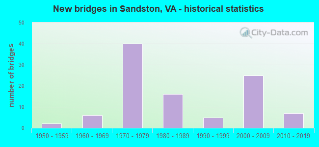
- New bridges - historical statistics
- 21950-1959
- 61960-1969
- 401970-1979
- 161980-1989
- 51990-1999
- 252000-2009
- 72010-2019
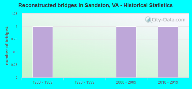
- Reconstructed bridges - Historical Statistics
- 11980-1989
- 01990-1999
- 12000-2009
- 12010-2019
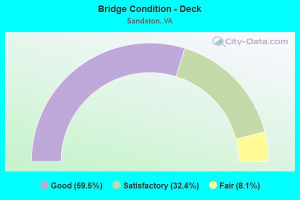
- Bridge Condition - Deck
- 59.5%Good
- 32.4%Satisfactory
- 8.1%Fair
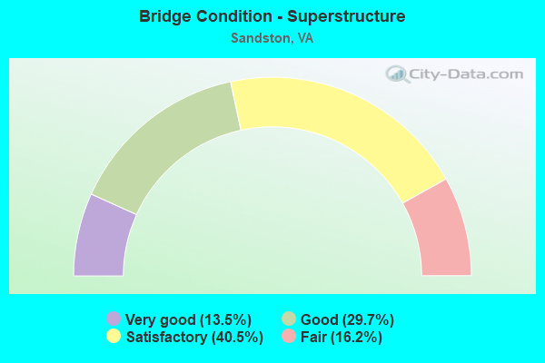
- Bridge Condition - Superstructure
- 13.5%Very good
- 29.7%Good
- 40.5%Satisfactory
- 16.2%Fair
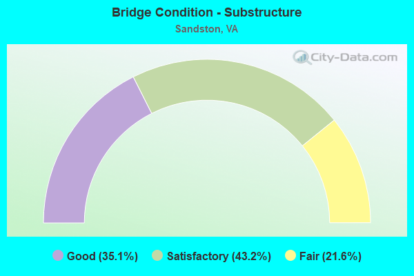
- Bridge Condition - Substructure
- 35.1%Good
- 43.2%Satisfactory
- 21.6%Fair
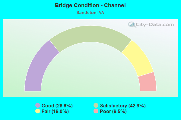
- Bridge Condition - Channel
- 28.6%Good
- 42.9%Satisfactory
- 19.0%Fair
- 9.5%Poor
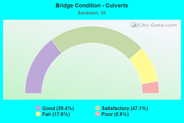
- Bridge Condition - Culverts
- 29.4%Good
- 47.1%Satisfactory
- 17.6%Fair
- 5.9%Poor
Find on map >> Show street view
Structure Number: 27264, Location: 2.2 LABURNUM AVE - MM3.3 (Lat: 37.479214, Lng: -77.348603), Route carried "on" structure: State highway 895, Year Built: 2002, Status: Open, Structure Length: 1.40m (4.59ft), Average Daily Traffic: 7,803 (year 2020), Truck Traffic: 7%, Average Future Daily Traffic: 8,583 (year 2040), Design Load: HS 20+Mod, Features Intersected: STREAM, Facility Carried by Structure: POCAHONTAS PARKWAY
Minimum Vertical Clearance: 30+ m (98+ ft), Kilometerpoint: 8.994, Lanes on structure: 4, Base Highway Network: Yes, Toll: On toll road, Owner: State Highway Agency, Maintenance Responsibility: Private, Approaching Roadway Width: 14.6m (47.9ft), Skew: 24 degrees, Material/Design: Concrete, Design/Construction: Culvert, Number Of Spans In Main Unit: 3, Length of Maximum Span: 4.6m (15.1ft)
Condition: Channel: Satisfactory, Culverts: Good, Operating Rating: 89.8 metric tons, Method Used To Determine Operating Rating: Field evaluation and documented engineering judgment, Inventory Rating: 89.8 metric tons, Method Used To Determine Inventory Rating: Field evaluation and documented engineering judgment, Structural Evaluation: Better than present minimum criteria, Waterway Adequacy: Equal to present desirable criteria, Approach Roadway Alignment: Equal to present desirable criteria, Designated Inspection Frequency: Every 24 months, Inspection Date: June 2020
Find on map >> Show street view
Structure Number: 27265, Location: 3.2 FR. I-295 MM 3.2 (Lat: 37.479622, Lng: -77.344669), Route carried "on" structure: State highway 895, Year Built: 2002, Year Reconstructed: 2010, Status: Open, Structure Length: 1.01m (3.31ft), Average Daily Traffic: 7,803 (year 2020), Truck Traffic: 7%, Average Future Daily Traffic: 8,583 (year 2040), Design Load: HS 20+Mod, Features Intersected: STREAM, Facility Carried by Structure: POCAHONTAS PARKWAY
Minimum Vertical Clearance: 30+ m (98+ ft), Kilometerpoint: 9.236, Lanes on structure: 5, Base Highway Network: Yes, Toll: On toll road, Owner: State Highway Agency, Maintenance Responsibility: Private, Approaching Roadway Width: 14.6m (47.9ft), Skew: 22 degrees, Material/Design: Concrete, Design/Construction: Culvert, Number Of Spans In Main Unit: 3, Length of Maximum Span: 3.4m (11.2ft)
Condition: Channel: Good, Culverts: Good, Operating Rating: 89.8 metric tons, Method Used To Determine Operating Rating: Field evaluation and documented engineering judgment, Inventory Rating: 89.8 metric tons, Method Used To Determine Inventory Rating: Field evaluation and documented engineering judgment, Structural Evaluation: Better than present minimum criteria, Waterway Adequacy: Equal to present desirable criteria, Approach Roadway Alignment: Equal to present desirable criteria, Designated Inspection Frequency: Every 24 months, Inspection Date: June 2020
Find on map >> Show street view
Structure Number: 27318, Location: 3.2 FR. RTE 5 (Lat: 37.473175, Lng: -77.306014), Route carried "on" structure: Ramp Interstate 295, Year Built: 2002, Status: Open, Structure Length: 9.57m (31.40ft), Average Daily Traffic: 15,564 (year 2020), Truck Traffic: 22%, Average Future Daily Traffic: 21,790 (year 2040), Design Load: HS 20+Mod, Features Intersected: I-295
Minimum Vertical Clearance: 30+ m (98+ ft), Kilometerpoint: 0.000, Lanes on structure: 1, Lanes under structure: 7, Base Highway Network: Yes, Toll: On toll road, Owner: State Highway Agency, Maintenance Responsibility: Private, Approaching Roadway Width: 8.8m (28.9ft), Skew: 2 degrees, Material/Design: Steel continuous, Design/Construction: Stringer/Multi-beam, Number Of Spans In Main Unit: 2, Length of Maximum Span: 49.4m (162.1ft), Curb-To-Curb Width: 9.0m (29.5ft), Out-to-Out Width: 10.0m (32.8ft)
Condition: Deck: Good, Superstructure: Good, Substructure: Good, Operating Rating: 53.3 metric tons, Method Used To Determine Operating Rating: Load and Resistance Factor (LRFR), Inventory Rating: 41.2 metric tons, Method Used To Determine Inventory Rating: Load and Resistance Factor (LRFR), Structural Evaluation: Better than present minimum criteria, Deck Geometry: Superior to present desirable criteria, Underclear: Better than present minimum criteria, Approach Roadway Alignment: Equal to present minimum criteria, Designated Inspection Frequency: Every 24 months, Inspection Date: October 2020, Deck Structure Type: Concrete Cast-file-Place, Wearing Surface/Protective System: Deck Protection: Epoxy Coated Reinforcing
Find on map >> Show street view
Structure Number: 27368, Location: 1.7 FR I-295 (Lat: 37.478514, Lng: -77.338883), Route carried "on" structure: State highway 895, Year Built: 2002, Status: Open, Structure Length: 1.11m (3.64ft), Average Daily Traffic: 7,803 (year 2020), Truck Traffic: 7%, Average Future Daily Traffic: 8,583 (year 2040), Design Load: HS 20+Mod, Features Intersected: STREAM, Facility Carried by Structure: POCAHONTAS PARKWAY
Minimum Vertical Clearance: 30+ m (98+ ft), Kilometerpoint: 9.334, Lanes on structure: 6, Base Highway Network: Yes, Toll: On toll road, Owner: State Highway Agency, Maintenance Responsibility: Private, Approaching Roadway Width: 29.3m (96.1ft), Skew: 20 degrees, Material/Design: Concrete, Design/Construction: Culvert, Number Of Spans In Main Unit: 3, Length of Maximum Span: 3.0m (9.8ft)
Condition: Channel: Satisfactory, Culverts: Satisfactory, Operating Rating: 89.8 metric tons, Method Used To Determine Operating Rating: Field evaluation and documented engineering judgment, Inventory Rating: 89.8 metric tons, Method Used To Determine Inventory Rating: Field evaluation and documented engineering judgment, Structural Evaluation: Equal to present minimum criteria, Waterway Adequacy: Equal to present desirable criteria, Approach Roadway Alignment: Equal to present desirable criteria, Designated Inspection Frequency: Every 24 months, Inspection Date: January 2021
Find on map >> Show street view
Structure Number: 27394, Location: .81 DARBYTN .58 CHAR CITY (Lat: 37.474086, Lng: -77.319381), Route carried "on" structure: County highway , Year Built: 2004, Status: Open, Structure Length: 7.89m (25.89ft), Average Daily Traffic: 728 (year 2020), Truck Traffic: 7%, Average Future Daily Traffic: 801 (year 2040), Design Load: HS 20+Mod, Features Intersected: ROUTE 895 POCAHONTAS PKW, Facility Carried by Structure: BRITTON ROAD
Minimum Vertical Clearance: 30+ m (98+ ft), Kilometerpoint: 1.046, Lanes on structure: 2, Lanes under structure: 4, Owner: State Highway Agency, Maintenance Responsibility: Private, Approaching Roadway Width: 9.9m (32.5ft), Skew: 3 degrees, Material/Design: Prestressed concrete continuous, Design/Construction: Stringer/Multi-beam, Number Of Spans In Main Unit: 2, Length of Maximum Span: 38.1m (125.0ft), Curb-To-Curb Width: 9.9m (32.5ft), Out-to-Out Width: 10.9m (35.8ft)
Condition: Deck: Good, Superstructure: Good, Substructure: Good, Operating Rating: 88.4 metric tons, Method Used To Determine Operating Rating: Load and Resistance Factor (LRFR), Inventory Rating: 63.0 metric tons, Method Used To Determine Inventory Rating: Load and Resistance Factor (LRFR), Structural Evaluation: Better than present minimum criteria, Deck Geometry: Equal to present minimum criteria, Underclear: Better than present minimum criteria, Approach Roadway Alignment: Equal to present desirable criteria, Designated Inspection Frequency: Every 24 months, Inspection Date: August 2020, Deck Structure Type: Concrete Cast-file-Place, Wearing Surface/Protective System: Deck Protection: Epoxy Coated Reinforcing
Find on map >> Show street view
Structure Number: 27603, Location: 0.05 FR FISHER CREST LANE (Lat: 37.470508, Lng: -77.262356), Route carried "on" structure: County highway 77230, Year Built: 1998, Status: Open, Structure Length: 0.79m (2.59ft), Average Daily Traffic: 729 (year 2020), Truck Traffic: 3%, Average Future Daily Traffic: 1,021 (year 2040), Design Load: HS 20+Mod, Features Intersected: DEEP RUN CREEK, Facility Carried by Structure: CHARLES CITY ROAD
Minimum Vertical Clearance: 30+ m (98+ ft), Kilometerpoint: 12.148, Lanes on structure: 2, Owner: County Highway Agency, Approaching Roadway Width: 7.3m (24.0ft), Material/Design: Concrete, Design/Construction: Culvert, Number Of Spans In Main Unit: 2, Length of Maximum Span: 3.7m (12.1ft)
Condition: Channel: Satisfactory, Culverts: Satisfactory, Operating Rating: 68.0 metric tons, Method Used To Determine Operating Rating: Field evaluation and documented engineering judgment, Inventory Rating: 40.8 metric tons, Method Used To Determine Inventory Rating: Field evaluation and documented engineering judgment, Structural Evaluation: Equal to present minimum criteria, Waterway Adequacy: Superior to present desirable criteria, Approach Roadway Alignment: Equal to present desirable criteria, Designated Inspection Frequency: Every 24 months, Inspection Date: July 2021
Find on map >> Show street view
Structure Number: 27604, Location: 0.10 AUDUBON .20 DEAD END (Lat: 37.526092, Lng: -77.330047), Route carried "on" structure: County highway , Year Built: 1995, Status: Open, Structure Length: 1.12m (3.67ft), Average Daily Traffic: 2,262 (year 2017), Truck Traffic: 5%, Average Future Daily Traffic: 2,679 (year 2034), Design Load: HS 20+Mod, Features Intersected: STREAM, Facility Carried by Structure: INTERNATNL CENT DR
Minimum Vertical Clearance: 30+ m (98+ ft), Kilometerpoint: 0.000, Lanes on structure: 2, Owner: County Highway Agency, Approaching Roadway Width: 15.9m (52.2ft), Skew: 3 degrees, Material/Design: Concrete, Design/Construction: Culvert, Number Of Spans In Main Unit: 4, Length of Maximum Span: 2.1m (6.9ft)
Condition: Channel: Satisfactory, Culverts: Fair, Operating Rating: 64.4 metric tons, Method Used To Determine Operating Rating: Load Factor (LF), Inventory Rating: 38.1 metric tons, Method Used To Determine Inventory Rating: Load Factor (LF), Structural Evaluation: Somewhat better than minimum adequacy, Waterway Adequacy: Superior to present desirable criteria, Approach Roadway Alignment: Equal to present desirable criteria, Designated Inspection Frequency: Every 24 months, Inspection Date: July 2021
Find on map >> Show street view
Structure Number: 29518, Location: .4 FR 895 EB/3.3 To 60 (Lat: 37.478794, Lng: -77.339847), Route carried "on" structure: Bypass Other road 281, Year Built: 2011, Status: Open, Structure Length: 6.00m (19.69ft), Average Daily Traffic: 3,553 (year 2020), Truck Traffic: 10%, Average Future Daily Traffic: 4,974 (year 2040), Design Load: HS 20+Mod, Features Intersected: RTE 895, Facility Carried by Structure: AIRPORT DRIVE
Minimum Vertical Clearance: 30+ m (98+ ft), Kilometerpoint: 0.000, Lanes on structure: 2, Lanes under structure: 4, Toll: On toll road, Owner: State Highway Agency, Maintenance Responsibility: Private, Approaching Roadway Width: 21.0m (68.9ft), Skew: 21 degrees, Material/Design: Prestressed concrete continuous, Design/Construction: Stringer/Multi-beam, Number Of Spans In Main Unit: 2, Length of Maximum Span: 31.1m (102.0ft), Curb-To-Curb Width: 8.1m (26.6ft), Out-to-Out Width: 22.0m (72.2ft)
Condition: Deck: Good, Superstructure: Good, Substructure: Good, Operating Rating: 48.8 metric tons, Method Used To Determine Operating Rating: Load Factor (LF), Inventory Rating: 34.3 metric tons, Method Used To Determine Inventory Rating: Load Factor (LF), Structural Evaluation: Better than present minimum criteria, Deck Geometry: High priority of corrective action, Underclear: Superior to present desirable criteria, Approach Roadway Alignment: Equal to present minimum criteria, Designated Inspection Frequency: Every 24 months, Inspection Date: March 2021, Deck Structure Type: Concrete Cast-file-Place, Wearing Surface/Protective System: Deck Protection: Epoxy Coated Reinforcing
Find on map >> Show street view
Structure Number: 29519, Location: 1.1 FR 895/2.2 TO 60 (Lat: 37.494069, Lng: -77.341239), Route carried "on" structure: County highway 281, Year Built: 2011, Status: Open, Structure Length: 3.34m (10.96ft), Average Daily Traffic: 3,553 (year 2020), Truck Traffic: 10%, Average Future Daily Traffic: 4,974 (year 2040), Design Load: HS 20+Mod, Features Intersected: SPROUSE ROAD, Facility Carried by Structure: AIRPORT DRIVE
Minimum Vertical Clearance: 30+ m (98+ ft), Kilometerpoint: 0.000, Lanes on structure: 4, Lanes under structure: 4, Base Highway Network: Yes, Toll: On toll road, Owner: State Highway Agency, Maintenance Responsibility: Private, Approaching Roadway Width: 25.8m (84.6ft), Skew: 21 degrees, Material/Design: Prestressed concrete, Design/Construction: Stringer/Multi-beam, Number Of Spans In Main Unit: 1, Length of Maximum Span: 32.8m (107.6ft), Curb-To-Curb Width: 21.0m (68.9ft), Out-to-Out Width: 26.8m (87.9ft)
Condition: Deck: Good, Superstructure: Very good, Substructure: Good, Operating Rating: 61.6 metric tons, Method Used To Determine Operating Rating: Load and Resistance Factor (LRFR), Inventory Rating: 47.5 metric tons, Method Used To Determine Inventory Rating: Load and Resistance Factor (LRFR), Structural Evaluation: Better than present minimum criteria, Deck Geometry: Superior to present desirable criteria, Underclear: Superior to present desirable criteria, Approach Roadway Alignment: Superior to present desirable criteria, Designated Inspection Frequency: Every 24 months, Inspection Date: March 2021, Deck Structure Type: Concrete Cast-file-Place, Wearing Surface/Protective System: Wearing Surface: Monolithic Concrete, Deck Protection: Epoxy Coated Reinforcing
Find on map >> Show street view
Structure Number: 2952, Location: 1.3 FR 895/2 TO 60 (Lat: 37.478814, Lng: -77.339931), Route carried "on" structure: State highway 281, Year Built: 2011, Status: Open, Structure Length: 4.92m (16.14ft), Average Daily Traffic: 3,553 (year 2020), Truck Traffic: 2%, Average Future Daily Traffic: 4,974 (year 2040), Design Load: HS 20+Mod, Features Intersected: CSX RAILROAD, Facility Carried by Structure: AIRPORT DRIVE
Minimum Vertical Clearance: 30+ m (98+ ft), Kilometerpoint: 0.000, Lanes on structure: 4, Toll: On toll road, Owner: State Highway Agency, Maintenance Responsibility: Private, Approaching Roadway Width: 25.8m (84.6ft), Skew: 20 degrees, Material/Design: Steel, Design/Construction: Stringer/Multi-beam, Number Of Spans In Main Unit: 1, Length of Maximum Span: 48.5m (159.1ft), Curb-To-Curb Width: 25.8m (84.6ft), Out-to-Out Width: 26.8m (87.9ft)
Condition: Deck: Good, Superstructure: Very good, Substructure: Good, Operating Rating: 89.8 metric tons, Method Used To Determine Operating Rating: Load Factor (LF), Inventory Rating: 58.8 metric tons, Method Used To Determine Inventory Rating: Load Factor (LF), Structural Evaluation: Better than present minimum criteria, Deck Geometry: Superior to present desirable criteria, Underclear: Equal to present desirable criteria, Approach Roadway Alignment: Somewhat better than minimum adequacy, Designated Inspection Frequency: Every 24 months, Inspection Date: March 2021, Deck Structure Type: Concrete Cast-file-Place, Wearing Surface/Protective System: Wearing Surface: Monolithic Concrete, Deck Protection: Epoxy Coated Reinforcing
Find on map >> Show street view
Structure Number: 30216, Location: .11 FR TECHNOLOGY BLVD (Lat: 37.491389, Lng: -77.238667), Route carried "on" structure: County highway , Year Built: 2013, Status: Open, Structure Length: 0.85m (2.79ft), Average Daily Traffic: 14,007 (year 2019), Truck Traffic: 10%, Average Future Daily Traffic: 16,589 (year 2038), Design Load: HS 20, Features Intersected: WHITE OAK CREEK, Facility Carried by Structure: WHITE OAK CREEK DR
Minimum Vertical Clearance: 30+ m (98+ ft), Kilometerpoint: 0.000, Lanes on structure: 2, Owner: County Highway Agency, Approaching Roadway Width: 12.3m (40.4ft), Skew: 1 degrees, Material/Design: Concrete, Design/Construction: Culvert, Number Of Spans In Main Unit: 4, Length of Maximum Span: 1.8m (5.9ft)
Condition: Channel: Fair, Culverts: Good, Operating Rating: 54.4 metric tons, Method Used To Determine Operating Rating: Load Factor (LF), Inventory Rating: 32.7 metric tons, Method Used To Determine Inventory Rating: Load Factor (LF), Structural Evaluation: Better than present minimum criteria, Waterway Adequacy: Superior to present desirable criteria, Approach Roadway Alignment: Equal to present desirable criteria, Designated Inspection Frequency: Every 24 months, Inspection Date: June 2021
Find on map >> Show street view
Structure Number: 31517, Location: .04frFireAcad .16toFalcon (Lat: 37.511278, Lng: -77.307194), Route carried "on" structure: County highway , Year Built: 2015, Status: Open, Structure Length: 0.64m (2.10ft), Average Daily Traffic: 100 (year 2021), Average Future Daily Traffic: 118 (year 2038), Design Load: HS 20, Features Intersected: White Oak Swamp Crk, Facility Carried by Structure: Eastside Road
Minimum Vertical Clearance: 30+ m (98+ ft), Kilometerpoint: 0.000, Lanes on structure: 2, Owner: County Highway Agency, Approaching Roadway Width: 15.8m (51.8ft), Skew: 2 degrees, Material/Design: Concrete, Design/Construction: Culvert, Number Of Spans In Main Unit: 2, Length of Maximum Span: 2.7m (8.9ft)
Condition: Channel: Satisfactory, Culverts: Good, Operating Rating: 54.5 metric tons, Method Used To Determine Operating Rating: Field evaluation and documented engineering judgment, Inventory Rating: 32.7 metric tons, Method Used To Determine Inventory Rating: Field evaluation and documented engineering judgment, Structural Evaluation: Better than present minimum criteria, Waterway Adequacy: Equal to present minimum criteria, Approach Roadway Alignment: Equal to present desirable criteria, Designated Inspection Frequency: Every 24 months, Inspection Date: March 2021
Find on map >> Show street view
Structure Number: 962, Location: .2 WILMSBG & .2 DRYBR CT (Lat: 37.523006, Lng: -77.281175), Route carried "under" structure: Interstate 64, Year Built: 1979, Structure Length: 0. m, Average Daily Traffic: 64,000 (year 2020), Truck Traffic: 10%, Features Intersected: RTE I 64, Facility Carried by Structure: DRY BRIDGE ROAD
Minimum Vertical Clearance: 6.30m (20.67ft), Kilometerpoint: 322.605, Lanes on structure: 2, Lanes under structure: 4, Material/Design: Steel continuous, Design/Construction: Stringer/Multi-beam, Length of Maximum Span: 36.3m (119.1ft)
Find on map >> Show street view
Structure Number: 962, Location: .2 WILMSBG & .2 DRYBR CT (Lat: 37.523006, Lng: -77.281175), Route carried "under" structure: Ramp Interstate 64, Year Built: 1979, Structure Length: 0. m, Average Daily Traffic: 3,500 (year 2020), Truck Traffic: 24%, Features Intersected: RTE I 64, Facility Carried by Structure: DRY BRIDGE ROAD
Minimum Vertical Clearance: 5.73m (18.80ft), Kilometerpoint: 0.161, Lanes on structure: 2, Lanes under structure: 2, Material/Design: Steel continuous, Design/Construction: Stringer/Multi-beam, Length of Maximum Span: 36.3m (119.1ft)
Find on map >> Show street view
Structure Number: 962, Location: .2 WILMSBG & .2 DRYBR CT (Lat: 37.523006, Lng: -77.281175), Route carried "under" structure: Ramp Interstate 64, Year Built: 1979, Structure Length: 0. m, Average Daily Traffic: 3,400 (year 2020), Truck Traffic: 14%, Features Intersected: RTE I 64, Facility Carried by Structure: DRY BRIDGE ROAD
Minimum Vertical Clearance: 6.17m (20.24ft), Kilometerpoint: 2.188, Lanes on structure: 2, Lanes under structure: 2, Material/Design: Steel continuous, Design/Construction: Stringer/Multi-beam, Length of Maximum Span: 36.3m (119.1ft)
Find on map >> Show street view
Structure Number: 9628, Location: 0.60FINLAY ST0.30HOLLY AV (Lat: 37.531028, Lng: -77.344661), Route carried "under" structure: Interstate 64, Year Built: 1964, Structure Length: 0. m, Average Daily Traffic: 53,000 (year 2019), Truck Traffic: 4%, Features Intersected: I-64, Facility Carried by Structure: OAKLEYS LANE
Minimum Vertical Clearance: 5.28m (17.32ft), Kilometerpoint: 316.651, Lanes on structure: 2, Lanes under structure: 6, Material/Design: Steel, Design/Construction: Stringer/Multi-beam, Length of Maximum Span: 25.0m (82.0ft)
Find on map >> Show street view
Structure Number: 9632, Location: 0.07WOODVIEW 0.2833 (60) (Lat: 37.513489, Lng: -77.240464), Route carried "under" structure: Interstate 64, Year Built: 1964, Structure Length: 0. m, Average Daily Traffic: 76,000 (year 2017), Truck Traffic: 9%, Features Intersected: ROUTE 0064, Facility Carried by Structure: MEADOW ROAD
Minimum Vertical Clearance: 5.36m (17.59ft), Kilometerpoint: 326.418, Lanes on structure: 2, Lanes under structure: 4, Material/Design: Steel, Design/Construction: Stringer/Multi-beam, Length of Maximum Span: 25.4m (83.3ft)
Find on map >> Show street view
Structure Number: 9672, Location: 0.2 DRYBRGE & 0.2 GRPEVIN (Lat: 37.529875, Lng: -77.274658), Route carried "under" structure: Ramp Interstate 295, Year Built: 1978, Structure Length: 0. m, Average Daily Traffic: 16,000 (year 2020), Truck Traffic: 12%, Features Intersected: ROUTE I-295, Facility Carried by Structure: MEADOW ROAD
Minimum Vertical Clearance: 5.74m (18.83ft), Kilometerpoint: 3.363, Lanes on structure: 2, Lanes under structure: 2, Material/Design: Steel continuous, Design/Construction: Stringer/Multi-beam, Length of Maximum Span: 60.4m (198.2ft)
Find on map >> Show street view
Structure Number: 9672, Location: 0.2 DRYBRGE & 0.2 GRPEVIN (Lat: 37.529875, Lng: -77.274658), Route carried "under" structure: Interstate 295, Year Built: 1978, Structure Length: 0. m, Average Daily Traffic: 60,000 (year 2020), Truck Traffic: 12%, Features Intersected: ROUTE I-295, Facility Carried by Structure: MEADOW ROAD
Minimum Vertical Clearance: 6.53m (21.42ft), Kilometerpoint: 37.184, Lanes on structure: 2, Lanes under structure: 7, Material/Design: Steel continuous, Design/Construction: Stringer/Multi-beam, Length of Maximum Span: 60.4m (198.2ft)
Find on map >> Show street view
Structure Number: 9672, Location: 0.2 DRYBRGE & 0.2 GRPEVIN (Lat: 37.529875, Lng: -77.274658), Route carried "under" structure: Ramp Interstate 295, Year Built: 1978, Structure Length: 0. m, Average Daily Traffic: 2,000 (year 1997), Features Intersected: ROUTE I-295, Facility Carried by Structure: MEADOW ROAD
Minimum Vertical Clearance: 4.95m (16.24ft), Kilometerpoint: 0.386, Lanes on structure: 2, Lanes under structure: 2, Material/Design: Steel continuous, Design/Construction: Stringer/Multi-beam, Length of Maximum Span: 60.4m (198.2ft)
Find on map >> Show street view
Structure Number: 9705, Location: 1.01BEULAH RD0.63PORTUGEE (Lat: 37.496894, Lng: -77.286856), Route carried "under" structure: Interstate 295, Year Built: 1987, Structure Length: 0. m, Average Daily Traffic: 44,000 (year 2019), Truck Traffic: 23%, Features Intersected: ROUTE I-295, Facility Carried by Structure: LAFRANCE ROAD
Minimum Vertical Clearance: 5.36m (17.59ft), Kilometerpoint: 41.979, Lanes on structure: 2, Lanes under structure: 6, Material/Design: Steel continuous, Design/Construction: Frame, Length of Maximum Span: 26.9m (88.3ft)
Find on map >> Show street view
Structure Number: 9707, Location: 0.43BEULAH RD0.05TURNER R (Lat: 37.477169, Lng: -77.304794), Route carried "under" structure: Interstate 295, Year Built: 1987, Structure Length: 0. m, Average Daily Traffic: 43,000 (year 2018), Truck Traffic: 22%, Features Intersected: I-295, Facility Carried by Structure: CHARLES CITY ROAD
Minimum Vertical Clearance: 5.61m (18.41ft), Kilometerpoint: 44.521, Lanes on structure: 2, Lanes under structure: 8, Material/Design: Steel continuous, Design/Construction: Stringer/Multi-beam, Length of Maximum Span: 39.4m (129.3ft)
Find on map >> Show street view
Structure Number: 9748, Location: 0.9 WHTSDE RD & 1.98 156 (Lat: 37.510333, Lng: -77.275800), Route carried "under" structure: Ramp Interstate 295, Year Built: 1979, Structure Length: 0. m, Average Daily Traffic: 2,000 (year 1999), Truck Traffic: 2%, Features Intersected: RTE I 295, Facility Carried by Structure: WBL WILLIAMSBURG
Minimum Vertical Clearance: 5.05m (16.57ft), Kilometerpoint: 2.961, Lanes on structure: 3, Lanes under structure: 3, Material/Design: Steel, Design/Construction: Stringer/Multi-beam, Length of Maximum Span: 37.2m (122.0ft)
Find on map >> Show street view
Structure Number: 9748, Location: 0.9 WHTSDE RD & 1.98 156 (Lat: 37.510333, Lng: -77.275800), Route carried "under" structure: Ramp Interstate 295, Year Built: 1979, Structure Length: 0. m, Average Daily Traffic: 2,000 (year 1999), Truck Traffic: 2%, Features Intersected: RTE I 295, Facility Carried by Structure: WBL WILLIAMSBURG
Minimum Vertical Clearance: 5.26m (17.26ft), Kilometerpoint: 1.046, Lanes on structure: 3, Lanes under structure: 3, Material/Design: Steel, Design/Construction: Stringer/Multi-beam, Length of Maximum Span: 37.2m (122.0ft)
Find on map >> Show street view
Structure Number: 9748, Location: 0.9 WHTSDE RD & 1.98 156 (Lat: 37.510333, Lng: -77.275800), Route carried "under" structure: Interstate 295, Year Built: 1979, Structure Length: 0. m, Average Daily Traffic: 36,000 (year 2020), Truck Traffic: 24%, Features Intersected: RTE I 295, Facility Carried by Structure: WBL WILLIAMSBURG
Minimum Vertical Clearance: 5.69m (18.67ft), Kilometerpoint: 39.437, Lanes on structure: 3, Lanes under structure: 6, Material/Design: Steel, Design/Construction: Stringer/Multi-beam, Length of Maximum Span: 37.2m (122.0ft)
Find on map >> Show street view
Structure Number: 975, Location: 0.7 DRYBRGE & 1.6 MT.ZION (Lat: 37.510181, Lng: -77.275906), Route carried "under" structure: Ramp Interstate 295, Year Built: 1979, Structure Length: 0. m, Average Daily Traffic: 11,000 (year 2017), Features Intersected: RTE I 295, Facility Carried by Structure: EBL WILLIAMSBURG
Minimum Vertical Clearance: 5.61m (18.41ft), Kilometerpoint: 0.965, Lanes on structure: 3, Lanes under structure: 3, Material/Design: Steel, Design/Construction: Stringer/Multi-beam, Length of Maximum Span: 36.9m (121.1ft)
Find on map >> Show street view
Structure Number: 975, Location: 0.7 DRYBRGE & 1.6 MT.ZION (Lat: 37.510181, Lng: -77.275906), Route carried "under" structure: Ramp Interstate 295, Year Built: 1979, Structure Length: 0. m, Average Daily Traffic: 13,000 (year 2017), Truck Traffic: 2%, Features Intersected: RTE I 295, Facility Carried by Structure: EBL WILLIAMSBURG
Minimum Vertical Clearance: 5.31m (17.42ft), Kilometerpoint: 3.041, Lanes on structure: 3, Lanes under structure: 3, Material/Design: Steel, Design/Construction: Stringer/Multi-beam, Length of Maximum Span: 36.9m (121.1ft)
Find on map >> Show street view
Structure Number: 975, Location: 0.7 DRYBRGE & 1.6 MT.ZION (Lat: 37.510181, Lng: -77.275906), Route carried "under" structure: Interstate 295, Year Built: 1979, Structure Length: 0. m, Average Daily Traffic: 36,000 (year 2020), Truck Traffic: 24%, Features Intersected: RTE I 295, Facility Carried by Structure: EBL WILLIAMSBURG
Minimum Vertical Clearance: 6.04m (19.82ft), Kilometerpoint: 39.453, Lanes on structure: 3, Lanes under structure: 6, Material/Design: Steel, Design/Construction: Stringer/Multi-beam, Length of Maximum Span: 36.9m (121.1ft)
Find on map >> Show street view
Structure Number: 99, Location: 2.12 FR 156 & .84 TO 33 (Lat: 37.521736, Lng: -77.270586), Route carried "under" structure: Ramp Interstate 64, Year Built: 1979, Structure Length: 0. m, Average Daily Traffic: 7,900 (year 2014), Truck Traffic: 18%, Features Intersected: RTE I 64 & CD RD, Facility Carried by Structure: NBL ROUTE 0295
Minimum Vertical Clearance: 5.56m (18.24ft), Kilometerpoint: 1.239, Lanes on structure: 3, Lanes under structure: 3, Material/Design: Steel, Design/Construction: Stringer/Multi-beam, Length of Maximum Span: 37.8m (124.0ft)
Find on map >> Show street view
Structure Number: 99, Location: 2.12 FR 156 & .84 TO 33 (Lat: 37.521736, Lng: -77.270586), Route carried "under" structure: Ramp Interstate 64, Year Built: 1979, Structure Length: 0. m, Average Daily Traffic: 3,900 (year 2014), Truck Traffic: 12%, Features Intersected: RTE I 64 & CD RD, Facility Carried by Structure: NBL ROUTE 0295
Minimum Vertical Clearance: 5.13m (16.83ft), Kilometerpoint: 1.512, Lanes on structure: 3, Lanes under structure: 3, Material/Design: Steel, Design/Construction: Stringer/Multi-beam, Length of Maximum Span: 37.8m (124.0ft)
Find on map >> Show street view
Structure Number: 99, Location: 2.12 FR 156 & .84 TO 33 (Lat: 37.521736, Lng: -77.270586), Route carried "under" structure: Interstate 64, Year Built: 1979, Structure Length: 0. m, Average Daily Traffic: 64,000 (year 2020), Truck Traffic: 11%, Features Intersected: RTE I 64 & CD RD, Facility Carried by Structure: NBL ROUTE 0295
Minimum Vertical Clearance: 5.79m (19.00ft), Kilometerpoint: 323.409, Lanes on structure: 3, Lanes under structure: 4, Material/Design: Steel, Design/Construction: Stringer/Multi-beam, Length of Maximum Span: 37.8m (124.0ft)
Find on map >> Show street view
Structure Number: 9902, Location: .86 MEADOW RD & .54 TO 60 (Lat: 37.521900, Lng: -77.271161), Route carried "under" structure: Ramp Interstate 64, Year Built: 1979, Structure Length: 0. m, Average Daily Traffic: 3,900 (year 2020), Truck Traffic: 12%, Features Intersected: RTE I 64 & CD RDS, Facility Carried by Structure: SBL ROUTE 0295
Minimum Vertical Clearance: 5.16m (16.93ft), Kilometerpoint: 1.432, Lanes on structure: 3, Lanes under structure: 3, Material/Design: Steel, Design/Construction: Stringer/Multi-beam, Length of Maximum Span: 37.8m (124.0ft)
Find on map >> Show street view
Structure Number: 9902, Location: .86 MEADOW RD & .54 TO 60 (Lat: 37.521900, Lng: -77.271161), Route carried "under" structure: Ramp Interstate 64, Year Built: 1979, Structure Length: 0. m, Average Daily Traffic: 3,600 (year 2020), Truck Traffic: 18%, Features Intersected: RTE I 64 & CD RDS, Facility Carried by Structure: SBL ROUTE 0295
Minimum Vertical Clearance: 5.66m (18.57ft), Kilometerpoint: 1.319, Lanes on structure: 3, Lanes under structure: 3, Material/Design: Steel, Design/Construction: Stringer/Multi-beam, Length of Maximum Span: 37.8m (124.0ft)
Find on map >> Show street view
Structure Number: 9902, Location: .86 MEADOW RD & .54 TO 60 (Lat: 37.521900, Lng: -77.271161), Route carried "under" structure: Interstate 64, Year Built: 1979, Structure Length: 0. m, Average Daily Traffic: 64,000 (year 2020), Truck Traffic: 22%, Features Intersected: RTE I 64 & CD RDS, Facility Carried by Structure: SBL ROUTE 0295
Minimum Vertical Clearance: 5.87m (19.26ft), Kilometerpoint: 323.361, Lanes on structure: 3, Lanes under structure: 4, Material/Design: Steel, Design/Construction: Stringer/Multi-beam, Length of Maximum Span: 37.8m (124.0ft)
Find on map >> Show street view
Structure Number: 9904, Location: 2.12 FR 156 & 0.84 TO 33 (Lat: 37.521628, Lng: -77.269956), Route carried "under" structure: Interstate 64, Year Built: 1979, Structure Length: 0. m, Average Daily Traffic: 43,000 (year 2020), Truck Traffic: 4%, Features Intersected: RTE I-64 & CD RDS, Facility Carried by Structure: WBL RTE 0295 COLL
Minimum Vertical Clearance: 5.94m (19.49ft), Kilometerpoint: 323.457, Lanes on structure: 3, Lanes under structure: 4, Material/Design: Steel, Design/Construction: Stringer/Multi-beam, Length of Maximum Span: 37.8m (124.0ft)
Find on map >> Show street view
Structure Number: 9904, Location: 2.12 FR 156 & 0.84 TO 33 (Lat: 37.521628, Lng: -77.269956), Route carried "under" structure: Ramp Interstate 64, Year Built: 1979, Structure Length: 0. m, Average Daily Traffic: 2,000 (year 1999), Truck Traffic: 2%, Features Intersected: RTE I-64 & CD RDS, Facility Carried by Structure: WBL RTE 0295 COLL
Minimum Vertical Clearance: 5.76m (18.90ft), Kilometerpoint: 1.158, Lanes on structure: 3, Lanes under structure: 3, Material/Design: Steel, Design/Construction: Stringer/Multi-beam, Length of Maximum Span: 37.8m (124.0ft)
Find on map >> Show street view
Structure Number: 9904, Location: 2.12 FR 156 & 0.84 TO 33 (Lat: 37.521628, Lng: -77.269956), Route carried "under" structure: Ramp Interstate 64, Year Built: 1979, Structure Length: 0. m, Average Daily Traffic: 2,000 (year 1999), Truck Traffic: 2%, Features Intersected: RTE I-64 & CD RDS, Facility Carried by Structure: WBL RTE 0295 COLL
Minimum Vertical Clearance: 5.18m (16.99ft), Kilometerpoint: 1.593, Lanes on structure: 3, Lanes under structure: 3, Material/Design: Steel, Design/Construction: Stringer/Multi-beam, Length of Maximum Span: 37.8m (124.0ft)
Find on map >> Show street view
Structure Number: 9906, Location: 2.11 FR 156 & 0.9 TO 33 (Lat: 37.522103, Lng: -77.271886), Route carried "under" structure: Ramp Interstate 64, Year Built: 1979, Structure Length: 0. m, Average Daily Traffic: 3,200 (year 2014), Truck Traffic: 5%, Features Intersected: RTE I 64 & CD RDS, Facility Carried by Structure: SBL RTE 0295 COLL
Minimum Vertical Clearance: 5.18m (16.99ft), Kilometerpoint: 1.368, Lanes on structure: 3, Lanes under structure: 3, Material/Design: Steel, Design/Construction: Stringer/Multi-beam, Length of Maximum Span: 37.8m (124.0ft)
Find on map >> Show street view
Structure Number: 9906, Location: 2.11 FR 156 & 0.9 TO 33 (Lat: 37.522103, Lng: -77.271886), Route carried "under" structure: Interstate 64, Year Built: 1979, Structure Length: 0. m, Average Daily Traffic: 43,000 (year 2020), Truck Traffic: 4%, Features Intersected: RTE I 64 & CD RDS, Facility Carried by Structure: SBL RTE 0295 COLL
Minimum Vertical Clearance: 5.97m (19.59ft), Kilometerpoint: 323.312, Lanes on structure: 3, Lanes under structure: 4, Material/Design: Steel, Design/Construction: Stringer/Multi-beam, Length of Maximum Span: 37.8m (124.0ft)
Find on map >> Show street view
Structure Number: 9906, Location: 2.11 FR 156 & 0.9 TO 33 (Lat: 37.522103, Lng: -77.271886), Route carried "under" structure: Ramp Interstate 64, Year Built: 1979, Structure Length: 0. m, Average Daily Traffic: 7,900 (year 2014), Truck Traffic: 18%, Features Intersected: RTE I 64 & CD RDS, Facility Carried by Structure: SBL RTE 0295 COLL
Minimum Vertical Clearance: 5.72m (18.77ft), Kilometerpoint: 1.400, Lanes on structure: 3, Lanes under structure: 3, Material/Design: Steel, Design/Construction: Stringer/Multi-beam, Length of Maximum Span: 37.8m (124.0ft)
Find on map >> Show street view
Structure Number: 9977, Location: 1.75 TO 60 & 4.26 FR 5 (Lat: 37.490236, Lng: -77.294650), Route carried "under" structure: County highway , Year Built: 1987, Structure Length: 0. m, Average Daily Traffic: 1,000 (year 1994), Features Intersected: PORTUGEE ROAD, Facility Carried by Structure: SBL ROUTE 0295
Minimum Vertical Clearance: 7.62m (25.00ft), Kilometerpoint: 0.000, Lanes on structure: 3, Lanes under structure: 2, Material/Design: Steel, Design/Construction: Stringer/Multi-beam, Length of Maximum Span: 31.8m (104.3ft)
Find on map >> Show street view
Structure Number: 9979, Location: 1.75 TO 60 & 4.26 FR 5 (Lat: 37.490211, Lng: -77.294242), Route carried "under" structure: Interstate , Year Built: 1987, Structure Length: 0. m, Average Daily Traffic: 1,000 (year 1994), Features Intersected: PORTUGEE ROAD, Facility Carried by Structure: NBL ROUTE 0295
Minimum Vertical Clearance: 7.64m (25.07ft), Kilometerpoint: 0.000, Lanes on structure: 3, Lanes under structure: 2, Material/Design: Steel, Design/Construction: Stringer/Multi-beam, Length of Maximum Span: 31.8m (104.3ft)
Find on map >> Show street view
Structure Number: 9985, Location: 04.13 TO 60 & 1.88 TO 5 (Lat: 37.459900, Lng: -77.314914), Route carried "under" structure: County highway , Year Built: 1987, Structure Length: 0. m, Average Daily Traffic: 3,100 (year 2019), Truck Traffic: 3%, Features Intersected: DARBYTOWN ROAD, Facility Carried by Structure: SBL ROUTE 0295
Minimum Vertical Clearance: 5.11m (16.77ft), Kilometerpoint: 9.332, Lanes on structure: 3, Lanes under structure: 2, Material/Design: Steel, Design/Construction: Stringer/Multi-beam, Length of Maximum Span: 37.8m (124.0ft)
Find on map >> Show street view
Structure Number: 9987, Location: 4.13 TO 60 & 1.88 TO 5 (Lat: 37.459639, Lng: -77.314394), Route carried "under" structure: Interstate , Year Built: 1987, Structure Length: 0. m, Average Daily Traffic: 3,100 (year 2019), Truck Traffic: 3%, Features Intersected: DARBYTOWN ROAD, Facility Carried by Structure: NBL ROUTE 0295
Minimum Vertical Clearance: 5.01m (16.44ft), Kilometerpoint: 9.332, Lanes on structure: 3, Lanes under structure: 2, Material/Design: Steel, Design/Construction: Stringer/Multi-beam, Length of Maximum Span: 36.6m (120.1ft)
Find on map >> Show street view
Structure Number: 25643, Location: .37 FR 295E & 0.87 TO 64E (Lat: 37.521981, Lng: -77.271611), Route carried "under" structure: Interstate 64, Year Built: 2001, Structure Length: 0. m, Average Daily Traffic: 32,220 (year 2008), Truck Traffic: 4%, Features Intersected: I- 64 AND I-295, Facility Carried by Structure: SB I-295 FLYOVER
Minimum Vertical Clearance: 10.08m (33.07ft), Kilometerpoint: 323.345, Lanes on structure: 2, Lanes under structure: 4, Material/Design: Steel continuous, Design/Construction: Stringer/Multi-beam, Length of Maximum Span: 50.0m (164.0ft)
Find on map >> Show street view
Structure Number: 25643, Location: .37 FR 295E & 0.87 TO 64E (Lat: 37.521981, Lng: -77.271611), Route carried "under" structure: Interstate 295, Year Built: 2001, Structure Length: 0. m, Average Daily Traffic: 21,050 (year 2008), Truck Traffic: 12%, Features Intersected: I- 64 AND I-295
Minimum Vertical Clearance: 5.87m (19.26ft), Kilometerpoint: 39.018, Lanes on structure: 2, Lanes under structure: 6, Material/Design: Steel continuous, Design/Construction: Stringer/Multi-beam, Length of Maximum Span: 50.0m (164.0ft)
Find on map >> Show street view
Structure Number: 25643, Location: .37 FR 295E & 0.87 TO 64E (Lat: 37.521981, Lng: -77.271611), Route carried "under" structure: Ramp Interstate 64, Year Built: 2001, Structure Length: 0. m, Average Daily Traffic: 2,000 (year 1999), Features Intersected: I- 64 AND I-295, Facility Carried by Structure: SB I-295 FLYOVER
Minimum Vertical Clearance: 9.12m (29.92ft), Kilometerpoint: 1.352, Lanes on structure: 2, Lanes under structure: 3, Material/Design: Steel continuous, Design/Construction: Stringer/Multi-beam, Length of Maximum Span: 50.0m (164.0ft)
Find on map >> Show street view
Structure Number: 25643, Location: .37 FR 295E & 0.87 TO 64E (Lat: 37.521981, Lng: -77.271611), Route carried "under" structure: Ramp Interstate 64, Year Built: 2001, Structure Length: 0. m, Average Daily Traffic: 2,000 (year 1999), Features Intersected: I- 64 AND I-295, Facility Carried by Structure: SB I-295 FLYOVER
Minimum Vertical Clearance: 10.41m (34.15ft), Kilometerpoint: 1.400, Lanes on structure: 2, Lanes under structure: 3, Material/Design: Steel continuous, Design/Construction: Stringer/Multi-beam, Length of Maximum Span: 50.0m (164.0ft)
Find on map >> Show street view
Structure Number: 25643, Location: .37 FR 295E & 0.87 TO 64E (Lat: 37.521981, Lng: -77.271611), Route carried "under" structure: Ramp Interstate 295, Year Built: 2001, Structure Length: 0. m, Average Daily Traffic: 20,000 (year 1994), Features Intersected: I- 64 AND I-295
Minimum Vertical Clearance: 5.43m (17.81ft), Kilometerpoint: 2.011, Lanes on structure: 2, Lanes under structure: 18, Material/Design: Steel continuous, Design/Construction: Stringer/Multi-beam, Length of Maximum Span: 50.0m (164.0ft)
Find on map >> Show street view
Structure Number: 27157, Location: 1.2 FR RTE. 5 (Lat: 37.471150, Lng: -77.362250), Route carried "under" structure: State highway 895, Year Built: 2002, Structure Length: 0. m, Average Daily Traffic: 6,476 (year 2008), Truck Traffic: 3%, Features Intersected: ROUTE 0895, Facility Carried by Structure: WILLSON ROAD
Minimum Vertical Clearance: 5.36m (17.59ft), Kilometerpoint: 8.093, Lanes on structure: 2, Lanes under structure: 4, Toll: On toll road, Material/Design: Steel continuous, Design/Construction: Stringer/Multi-beam, Length of Maximum Span: 36.3m (119.1ft)
Find on map >> Show street view
Structure Number: 272, Location: 3.0 FR. INT. LABURNUM AVE (Lat: 37.478042, Lng: -77.351383), Route carried "under" structure: County highway 7559, Year Built: 2002, Structure Length: 0. m, Average Daily Traffic: 3,320 (year 2008), Truck Traffic: 2%, Features Intersected: DARBYTOWN ROAD, Facility Carried by Structure: EBL 00895
Minimum Vertical Clearance: 5.41m (17.75ft), Kilometerpoint: 5.680, Lanes on structure: 2, Lanes under structure: 2, Material/Design: Steel, Design/Construction: Stringer/Multi-beam, Length of Maximum Span: 34.1m (111.9ft)
Find on map >> Show street view
Structure Number: 27206, Location: 3.0 FR. INT. LABURNUM AVE (Lat: 37.478208, Lng: -77.351594), Route carried "under" structure: County highway 7559, Year Built: 2002, Structure Length: 0. m, Average Daily Traffic: 3,320 (year 2008), Truck Traffic: 2%, Features Intersected: DARBYTOWN ROAD, Facility Carried by Structure: WBL 895
Minimum Vertical Clearance: 6.62m (21.72ft), Kilometerpoint: 5.648, Lanes on structure: 2, Lanes under structure: 2, Material/Design: Steel, Design/Construction: Stringer/Multi-beam, Length of Maximum Span: 34.1m (111.9ft)
Find on map >> Show street view
Structure Number: 27207, Location: 4.0 FR LABURNUM AVE (Lat: 37.477322, Lng: -77.333517), Route carried "under" structure: County highway , Year Built: 2002, Structure Length: 0. m, Average Daily Traffic: 500 (year 2002), Features Intersected: MONAHAN ROAD, Facility Carried by Structure: EBL 00895
Minimum Vertical Clearance: 5.77m (18.93ft), Kilometerpoint: 0.000, Lanes on structure: 3, Lanes under structure: 2, Material/Design: Steel, Design/Construction: Stringer/Multi-beam, Length of Maximum Span: 34.2m (112.2ft)
Find on map >> Show street view
Structure Number: 27208, Location: 4.0 FR LABURNUM AVE (Lat: 37.477536, Lng: -77.333492), Route carried "under" structure: County highway , Year Built: 2002, Structure Length: 0. m, Average Daily Traffic: 500 (year 2002), Features Intersected: MONAHAN ROAD, Facility Carried by Structure: WBL 00895
Minimum Vertical Clearance: 5.49m (18.01ft), Kilometerpoint: 0.000, Lanes on structure: 2, Lanes under structure: 2, Material/Design: Steel, Design/Construction: Stringer/Multi-beam, Length of Maximum Span: 34.2m (112.2ft)
Find on map >> Show street view
Structure Number: 2721, Location: 0.0 FR I-295 (Lat: 37.470786, Lng: -77.308483), Route carried "under" structure: Interstate 295, Year Built: 2002, Structure Length: 0. m, Average Daily Traffic: 15,082 (year 2008), Truck Traffic: 10%, Features Intersected: ROUTE I-295, Facility Carried by Structure: LOOP B OF 895 EBL
Minimum Vertical Clearance: 6.02m (19.75ft), Kilometerpoint: 44.923, Lanes on structure: 1, Lanes under structure: 6, Material/Design: Steel continuous, Design/Construction: Stringer/Multi-beam, Length of Maximum Span: 42.7m (140.1ft)
Find on map >> Show street view
Structure Number: 27318, Location: 3.2 FR. RTE 5 (Lat: 37.473175, Lng: -77.306014), Route carried "under" structure: Interstate 295, Year Built: 2002, Structure Length: 0. m, Average Daily Traffic: 30,165 (year 2008), Truck Traffic: 10%, Features Intersected: I-295
Minimum Vertical Clearance: 5.61m (18.41ft), Kilometerpoint: 44.618, Lanes on structure: 1, Lanes under structure: 7, Material/Design: Steel continuous, Design/Construction: Stringer/Multi-beam, Length of Maximum Span: 49.4m (162.1ft)
Find on map >> Show street view
Structure Number: 27394, Location: .81 DARBYTN .58 CHAR CITY (Lat: 37.474086, Lng: -77.319381), Route carried "under" structure: State highway 895, Year Built: 2004, Structure Length: 0. m, Average Daily Traffic: 6,476 (year 2008), Truck Traffic: 3%, Features Intersected: ROUTE 895 POCAHONTAS PKW, Facility Carried by Structure: BRITTON ROAD
Minimum Vertical Clearance: 5.64m (18.50ft), Kilometerpoint: 11.472, Lanes on structure: 2, Lanes under structure: 4, Toll: On toll road, Material/Design: Prestressed concrete continuous, Design/Construction: Stringer/Multi-beam, Length of Maximum Span: 38.1m (125.0ft)
Find on map >> Show street view
Structure Number: 29518, Location: .4 FR 895 EB/3.3 To 60 (Lat: 37.478794, Lng: -77.339847), Route carried "under" structure: State highway 895, Year Built: 2011, Structure Length: 0. m, Average Daily Traffic: 5,400 (year 2012), Truck Traffic: 8%, Features Intersected: RTE 895, Facility Carried by Structure: AIRPORT DRIVE
Minimum Vertical Clearance: 5.41m (17.75ft), Kilometerpoint: 0.000, Lanes on structure: 2, Lanes under structure: 4, Toll: On toll road, Material/Design: Prestressed concrete continuous, Design/Construction: Stringer/Multi-beam, Length of Maximum Span: 31.1m (102.0ft)
Find on map >> Show street view
Structure Number: 29519, Location: 1.1 FR 895/2.2 TO 60 (Lat: 37.494069, Lng: -77.341239), Route carried "under" structure: County highway , Year Built: 2011, Structure Length: 0. m, Average Daily Traffic: 100 (year 2011), Truck Traffic: 10%, Features Intersected: SPROUSE ROAD, Facility Carried by Structure: AIRPORT DRIVE
Minimum Vertical Clearance: 5.79m (19.00ft), Kilometerpoint: 0.000, Lanes on structure: 4, Lanes under structure: 2, Material/Design: Prestressed concrete, Design/Construction: Stringer/Multi-beam, Length of Maximum Span: 32.8m (107.6ft)