Bridge Statistics for Scranton, Pennsylvania (PA)
Condition, Traffic, Stress, Structural Evaluation, Project Costs
- National Bridge Inventory (NBI) Statistics
- 113Number of bridges
- 774ft / 236mTotal length
- $17,504,000Total costs
- 1,238,086Total average daily traffic
- 124,769Total average daily truck traffic
- National Bridge Inventory (NBI) Registered Bridges for Scranton
- No street view available for this location
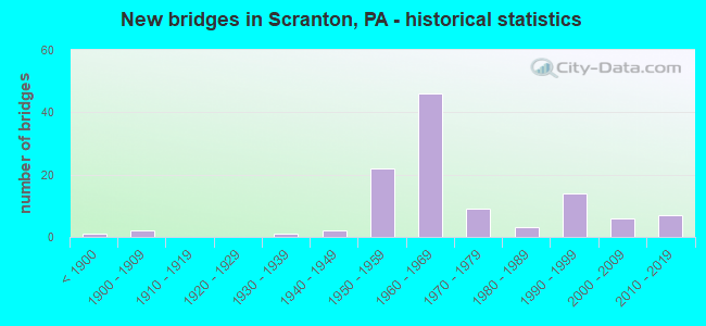
- New bridges - historical statistics
- 1Before 1900
- 21900-1909
- 11930-1939
- 21940-1949
- 221950-1959
- 461960-1969
- 91970-1979
- 31980-1989
- 141990-1999
- 62000-2009
- 72010-2019
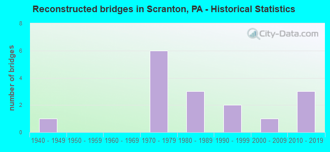
- Reconstructed bridges - Historical Statistics
- 11940-1949
- 01950-1959
- 01960-1969
- 61970-1979
- 31980-1989
- 21990-1999
- 12000-2009
- 32010-2019
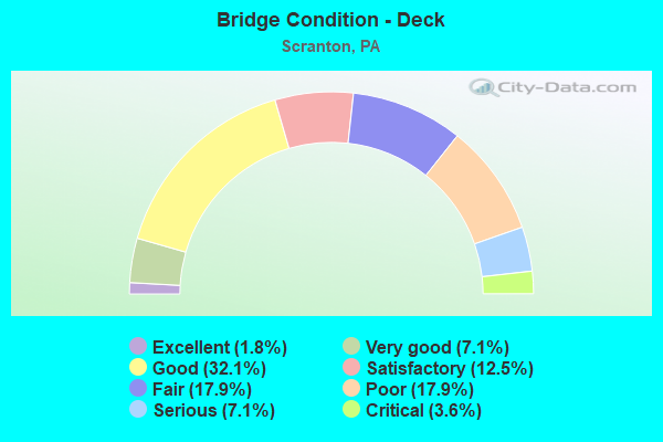
- Bridge Condition - Deck
- 1.8%Excellent
- 7.1%Very good
- 32.1%Good
- 12.5%Satisfactory
- 17.9%Fair
- 17.9%Poor
- 7.1%Serious
- 3.6%Critical
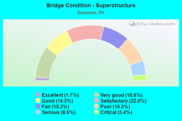
- Bridge Condition - Superstructure
- 1.7%Excellent
- 18.6%Very good
- 15.3%Good
- 22.0%Satisfactory
- 15.3%Fair
- 15.3%Poor
- 8.5%Serious
- 3.4%Critical
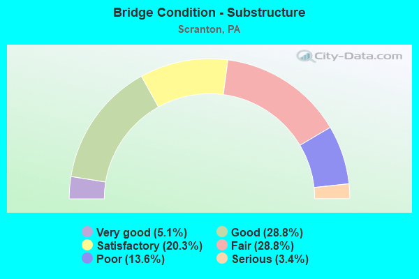
- Bridge Condition - Substructure
- 5.1%Very good
- 28.8%Good
- 20.3%Satisfactory
- 28.8%Fair
- 13.6%Poor
- 3.4%Serious
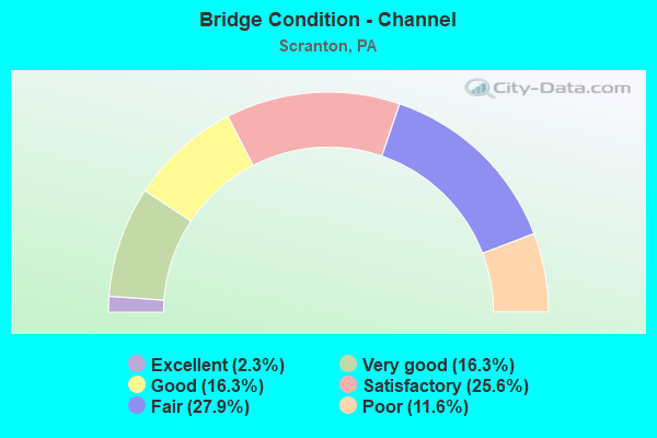
- Bridge Condition - Channel
- 2.3%Excellent
- 16.3%Very good
- 16.3%Good
- 25.6%Satisfactory
- 27.9%Fair
- 11.6%Poor
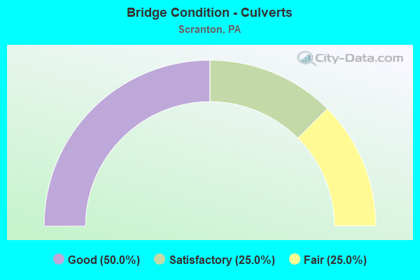
- Bridge Condition - Culverts
- 50.0%Good
- 25.0%Satisfactory
- 25.0%Fair
Find on map >> Show street view
Structure Number: 20442, Location: SCRANTON CITY RIVER ST (Lat: 41.393406, Lng: -75.651361), Route carried "under" structure: Interstate 81, Year Built: 1965, Structure Length: 0. m, Average Daily Traffic: 29,801 (year 2021), Truck Traffic: 19%, Features Intersected: SR 0081 I-81, Facility Carried by Structure: SR 3102 RIVER ST
Minimum Vertical Clearance: 5.70m (18.70ft), Kilometerpoint: 8.303, Lanes on structure: 4, Lanes under structure: 3, Material/Design: Steel, Design/Construction: Stringer/Multi-beam, Length of Maximum Span: 25.6m (84.0ft)
Find on map >> Show street view
Structure Number: 20442, Location: SCRANTON CITY RIVER ST (Lat: 41.393406, Lng: -75.651361), Route carried "under" structure: Interstate 81, Year Built: 1965, Structure Length: 0. m, Average Daily Traffic: 30,052 (year 2021), Truck Traffic: 19%, Features Intersected: SR 0081 I-81, Facility Carried by Structure: SR 3102 RIVER ST
Minimum Vertical Clearance: 5.43m (17.81ft), Kilometerpoint: 8.447, Lanes on structure: 4, Lanes under structure: 4, Material/Design: Steel, Design/Construction: Stringer/Multi-beam, Length of Maximum Span: 25.6m (84.0ft)
Find on map >> Show street view
Structure Number: 20443, Location: SCRANTON CTY OV MOOSIC ST (Lat: 41.478333, Lng: -75.563333), Route carried "under" structure: State highway 307, Year Built: 1965, Structure Length: 0. m, Average Daily Traffic: 8,152 (year 2021), Truck Traffic: 1%, Features Intersected: SR 0307 MOOSIC ST, Facility Carried by Structure: SR 0081 I-81 SB
Minimum Vertical Clearance: 4.44m (14.57ft), Kilometerpoint: 17.923, Lanes on structure: 2, Lanes under structure: 2, Material/Design: Prestressed concrete, Design/Construction: Stringer/Multi-beam, Length of Maximum Span: 26.5m (86.9ft)
Find on map >> Show street view
Structure Number: 20443, Location: SCRANTON CTY OV MOOSIC ST (Lat: 41.478333, Lng: -75.563333), Route carried "under" structure: State highway 307, Year Built: 1965, Structure Length: 0. m, Average Daily Traffic: 8,152 (year 2021), Truck Traffic: 1%, Features Intersected: SR 0307 MOOSIC ST, Facility Carried by Structure: SR 0081 I-81 SB
Minimum Vertical Clearance: 4.79m (15.72ft), Kilometerpoint: 17.923, Lanes on structure: 2, Lanes under structure: 2, Material/Design: Prestressed concrete, Design/Construction: Stringer/Multi-beam, Length of Maximum Span: 26.5m (86.9ft)
Find on map >> Show street view
Structure Number: 20444, Location: SCRANTON CITY OVER SR8005 (Lat: 41.395975, Lng: -75.644211), Route carried "under" structure: Ramp State highway , Year Built: 1966, Structure Length: 0. m, Average Daily Traffic: 3,739 (year 2021), Truck Traffic: 7%, Features Intersected: SR 8005, Facility Carried by Structure: SR 0081 I-81 NB
Minimum Vertical Clearance: 4.55m (14.93ft), Kilometerpoint: 0.000, Lanes on structure: 2, Lanes under structure: 2, Material/Design: Prestressed concrete, Design/Construction: Stringer/Multi-beam, Length of Maximum Span: 23.8m (78.1ft)
Find on map >> Show street view
Structure Number: 20445, Location: SCRANTON CITY OV RMPS A&C (Lat: 41.396422, Lng: -75.645519), Route carried "under" structure: Ramp State highway , Year Built: 1966, Structure Length: 0. m, Average Daily Traffic: 3,739 (year 2021), Truck Traffic: 7%, Features Intersected: SR 8005 RAMPS A & C, Facility Carried by Structure: SR 0081 I-81 SB
Minimum Vertical Clearance: 12.10m (39.70ft), Kilometerpoint: 0.000, Lanes on structure: 3, Lanes under structure: 2, Material/Design: Steel, Design/Construction: Stringer/Multi-beam, Length of Maximum Span: 31.4m (103.0ft)
Find on map >> Show street view
Structure Number: 20445, Location: SCRANTON CITY OV RMPS A&C (Lat: 41.396422, Lng: -75.645519), Route carried "under" structure: Ramp State highway , Year Built: 1966, Structure Length: 0. m, Average Daily Traffic: 4,421 (year 2021), Truck Traffic: 7%, Features Intersected: SR 8005 RAMPS A & C, Facility Carried by Structure: SR 0081 I-81 SB
Minimum Vertical Clearance: 4.95m (16.24ft), Kilometerpoint: 0.000, Lanes on structure: 3, Lanes under structure: 1, Material/Design: Steel, Design/Construction: Stringer/Multi-beam, Length of Maximum Span: 31.4m (103.0ft)
Find on map >> Show street view
Structure Number: 20456, Location: SCRANTON CTY OVER BLD AVE (Lat: 41.447889, Lng: -75.633278), Route carried "under" structure: City street , Year Built: 1958, Structure Length: 0. m, Average Daily Traffic: 200 (year 1992), Truck Traffic: 1%, Features Intersected: BOULEVARD AVENUE, Facility Carried by Structure: SR 0081 I-81
Minimum Vertical Clearance: 7.90m (25.92ft), Kilometerpoint: 0.000, Lanes on structure: 2, Lanes under structure: 2, Material/Design: Steel continuous, Design/Construction: Stringer/Multi-beam, Length of Maximum Span: 15.2m (49.9ft)
Find on map >> Show street view
Structure Number: 20459, Location: SCRANTON CTY OV N MAIN AV (Lat: 41.449917, Lng: -75.637739), Route carried "under" structure: City street , Year Built: 1958, Structure Length: 0. m, Average Daily Traffic: 200 (year 1992), Truck Traffic: 1%, Features Intersected: NORTH MAIN AVE, Facility Carried by Structure: SR 0081 I-81
Minimum Vertical Clearance: 4.68m (15.35ft), Kilometerpoint: 0.000, Lanes on structure: 3, Lanes under structure: 5, Material/Design: Steel, Design/Construction: Stringer/Multi-beam, Length of Maximum Span: 23.2m (76.1ft)
Find on map >> Show street view
Structure Number: 2046, Location: SCRANTON CITY ROCKWELL AV (Lat: 41.454997, Lng: -75.648300), Route carried "under" structure: Interstate 81, Year Built: 1958, Structure Length: 0. m, Average Daily Traffic: 26,651 (year 2022), Truck Traffic: 15%, Features Intersected: SR 0081 I-81, Facility Carried by Structure: SR 2107 COLIERY RD
Minimum Vertical Clearance: 5.16m (16.93ft), Kilometerpoint: 18.837, Lanes on structure: 2, Lanes under structure: 2, Material/Design: Steel continuous, Design/Construction: Stringer/Multi-beam, Length of Maximum Span: 25.3m (83.0ft)
Find on map >> Show street view
Structure Number: 2046, Location: SCRANTON CITY ROCKWELL AV (Lat: 41.454997, Lng: -75.648300), Route carried "under" structure: Interstate 81, Year Built: 1958, Structure Length: 0. m, Average Daily Traffic: 28,029 (year 2022), Truck Traffic: 15%, Features Intersected: SR 0081 I-81, Facility Carried by Structure: SR 2107 COLIERY RD
Minimum Vertical Clearance: 5.16m (16.93ft), Kilometerpoint: 18.924, Lanes on structure: 2, Lanes under structure: 4, Material/Design: Steel continuous, Design/Construction: Stringer/Multi-beam, Length of Maximum Span: 25.3m (83.0ft)
Find on map >> Show street view
Structure Number: 20461, Location: SCRANTON CITY OVER BUS 6 (Lat: 41.456892, Lng: -75.659981), Route carried "under" structure: US 6B, Year Built: 1958, Structure Length: 0. m, Average Daily Traffic: 15,525 (year 2022), Truck Traffic: 2%, Features Intersected: SR 6006 BUSINESS 6, Facility Carried by Structure: SR 0081 I-81
Minimum Vertical Clearance: 5.15m (16.90ft), Kilometerpoint: 0.369, Lanes on structure: 3, Lanes under structure: 3, Material/Design: Steel, Design/Construction: Stringer/Multi-beam, Length of Maximum Span: 26.8m (87.9ft)
Find on map >> Show street view
Structure Number: 20461, Location: SCRANTON CITY OVER BUS 6 (Lat: 41.456892, Lng: -75.659981), Route carried "under" structure: Ramp State highway , Year Built: 1958, Structure Length: 0. m, Average Daily Traffic: 3,803 (year 2021), Truck Traffic: 7%, Features Intersected: SR 6006 BUSINESS 6, Facility Carried by Structure: SR 0081 I-81
Minimum Vertical Clearance: 6.48m (21.26ft), Kilometerpoint: 0.000, Lanes on structure: 3, Lanes under structure: 1, Material/Design: Steel, Design/Construction: Stringer/Multi-beam, Length of Maximum Span: 26.8m (87.9ft)
Find on map >> Show street view
Structure Number: 20461, Location: SCRANTON CITY OVER BUS 6 (Lat: 41.456892, Lng: -75.659981), Route carried "under" structure: US 6B, Year Built: 1958, Structure Length: 0. m, Average Daily Traffic: 16,264 (year 2022), Truck Traffic: 4%, Features Intersected: SR 6006 BUSINESS 6, Facility Carried by Structure: SR 0081 I-81
Minimum Vertical Clearance: 5.63m (18.47ft), Kilometerpoint: 0.360, Lanes on structure: 3, Lanes under structure: 2, Material/Design: Steel, Design/Construction: Stringer/Multi-beam, Length of Maximum Span: 26.8m (87.9ft)
Find on map >> Show street view
Structure Number: 20564, Location: SCRANTON CTY OVER I-81 NB (Lat: 41.395536, Lng: -75.646625), Route carried "under" structure: Ramp State highway , Year Built: 1965, Structure Length: 0. m, Average Daily Traffic: 4,421 (year 2021), Truck Traffic: 7%, Features Intersected: SR 0081 I-81 NORTHBOUND, Facility Carried by Structure: TR 307 MOOSIC ST
Minimum Vertical Clearance: 4.65m (15.26ft), Kilometerpoint: 0.000, Lanes on structure: 2, Lanes under structure: 2, Material/Design: Prestressed concrete, Design/Construction: Stringer/Multi-beam, Length of Maximum Span: 34.1m (111.9ft)
Find on map >> Show street view
Structure Number: 20564, Location: SCRANTON CTY OVER I-81 NB (Lat: 41.395536, Lng: -75.646625), Route carried "under" structure: Interstate 81, Year Built: 1965, Structure Length: 0. m, Average Daily Traffic: 29,801 (year 2021), Truck Traffic: 19%, Features Intersected: SR 0081 I-81 NORTHBOUND, Facility Carried by Structure: TR 307 MOOSIC ST
Minimum Vertical Clearance: 5.28m (17.32ft), Kilometerpoint: 9.107, Lanes on structure: 2, Lanes under structure: 2, Material/Design: Prestressed concrete, Design/Construction: Stringer/Multi-beam, Length of Maximum Span: 34.1m (111.9ft)
Find on map >> Show street view
Structure Number: 20566, Location: SCRANTON OVER I-81 SR8005 (Lat: 41.396194, Lng: -75.648306), Route carried "under" structure: Ramp State highway , Year Built: 1966, Structure Length: 0. m, Average Daily Traffic: 3,543 (year 2021), Truck Traffic: 7%, Features Intersected: SR 8005 RAMP B, Facility Carried by Structure: TR 307 MOOSIC ST
Minimum Vertical Clearance: 4.43m (14.53ft), Kilometerpoint: 0.000, Lanes on structure: 2, Lanes under structure: 2, Material/Design: Prestressed concrete, Design/Construction: Box Beam or Girders - Single/Spread, Length of Maximum Span: 14.9m (48.9ft)
Find on map >> Show street view
Structure Number: 20951, Location: SCRANTON CITY (Lat: 41.425786, Lng: -75.710014), Route carried "under" structure: Business City street LOCL, Year Built: 1958, Structure Length: 0. m, Average Daily Traffic: 200 (year 1992), Features Intersected: DIVISION STREET, Facility Carried by Structure: PA TPK (I-476)
Minimum Vertical Clearance: 4.52m (14.83ft), Kilometerpoint: 0.000, Lanes on structure: 4, Lanes under structure: 2, Toll: On toll road, Material/Design: Concrete, Design/Construction: Tee Beam, Length of Maximum Span: 10.4m (34.1ft)
Find on map >> Show street view
Structure Number: 20952, Location: SCRANTON CITY (Lat: 41.434472, Lng: -75.702714), Route carried "under" structure: Interstate 476, Year Built: 1957, Structure Length: 0. m, Average Daily Traffic: 6,895 (year 2001), Truck Traffic: 19%, Features Intersected: PA TPK (I-476), Facility Carried by Structure: SR3003, LR952
Minimum Vertical Clearance: 4.50m (14.76ft), Kilometerpoint: 0.000, Lanes on structure: 2, Lanes under structure: 4, Material/Design: Steel, Design/Construction: Stringer/Multi-beam, Length of Maximum Span: 36.0m (118.1ft)
Find on map >> Show street view
Structure Number: 20963, Location: SCR C SR8005 RMP A OVER C (Lat: 41.396717, Lng: -75.645578), Route carried "under" structure: Ramp State highway , Year Built: 1966, Structure Length: 0. m, Average Daily Traffic: 3,739 (year 2021), Truck Traffic: 7%, Features Intersected: SR 8005 RAMP C, Facility Carried by Structure: SR 8005 RAMP A
Minimum Vertical Clearance: 4.81m (15.78ft), Kilometerpoint: 0.000, Lanes on structure: 1, Lanes under structure: 2, Material/Design: Steel, Design/Construction: Stringer/Multi-beam, Length of Maximum Span: 17.1m (56.1ft)
Find on map >> Show street view
Structure Number: 20968, Location: SCRANTON SPRUCE ST COMPLX (Lat: 41.404697, Lng: -75.660169), Route carried "under" structure: Ramp State highway , Year Built: 1969, Structure Length: 0. m, Average Daily Traffic: 2,733 (year 2022), Truck Traffic: 7%, Features Intersected: ROAR BR;RR;8025;SERV RD., Facility Carried by Structure: SR 8025
Minimum Vertical Clearance: 5.52m (18.11ft), Kilometerpoint: 0.000, Lanes on structure: 2, Lanes under structure: 3, Material/Design: Prestressed concrete, Design/Construction: Stringer/Multi-beam, Length of Maximum Span: 28.0m (91.9ft)
Find on map >> Show street view
Structure Number: 20968, Location: SCRANTON SPRUCE ST COMPLX (Lat: 41.404697, Lng: -75.660169), Route carried "under" structure: ServiceCity street , Year Built: 1969, Structure Length: 0. m, Average Daily Traffic: 1 (year 2004), Features Intersected: ROAR BR;RR;8025;SERV RD., Facility Carried by Structure: SR 8025
Minimum Vertical Clearance: 4.75m (15.58ft), Kilometerpoint: 0.000, Lanes on structure: 2, Lanes under structure: 2, Material/Design: Prestressed concrete, Design/Construction: Stringer/Multi-beam, Length of Maximum Span: 28.0m (91.9ft)
Find on map >> Show street view
Structure Number: 20969, Location: CTY SCRANTON SPRUCE COMPL (Lat: 41.403019, Lng: -75.660914), Route carried "under" structure: Ramp State highway , Year Built: 1969, Structure Length: 0. m, Average Daily Traffic: 2,819 (year 2022), Truck Traffic: 7%, Features Intersected: RAMP D SR 8025, Facility Carried by Structure: RAMP B SR 8025
Minimum Vertical Clearance: 5.33m (17.49ft), Kilometerpoint: 0.000, Lanes on structure: 1, Lanes under structure: 1, Material/Design: Prestressed concrete, Design/Construction: Stringer/Multi-beam, Length of Maximum Span: 11.0m (36.1ft)
Find on map >> Show street view
Structure Number: 39656, Location: SCRANTON OVR OLYPHANT AVE (Lat: 41.443039, Lng: -75.628386), Route carried "under" structure: City street , Year Built: 1997, Structure Length: 0. m, Average Daily Traffic: 200 (year 1992), Truck Traffic: 1%, Features Intersected: OLYPHANT AVENUE, Facility Carried by Structure: SR 0081 I-81 NB
Minimum Vertical Clearance: 4.99m (16.37ft), Kilometerpoint: 0.000, Lanes on structure: 2, Lanes under structure: 2, Material/Design: Prestressed concrete, Design/Construction: Box Beam or Girders - Single/Spread, Length of Maximum Span: 15.8m (51.8ft)
Find on map >> Show street view
Structure Number: 39666, Location: I-81 NB OVER ASH STREET (Lat: 41.406067, Lng: -75.631208), Route carried "under" structure: City street , Year Built: 1996, Structure Length: 0. m, Average Daily Traffic: 200 (year 1992), Truck Traffic: 1%, Features Intersected: ASH STREET, Facility Carried by Structure: SR 0081 I-81 NB
Minimum Vertical Clearance: 6.00m (19.69ft), Kilometerpoint: 0.000, Lanes on structure: 3, Lanes under structure: 2, Material/Design: Prestressed concrete, Design/Construction: Stringer/Multi-beam, Length of Maximum Span: 28.3m (92.8ft)
Find on map >> Show street view
Structure Number: 39667, Location: I-81 SB OVER ASH STREET (Lat: 41.346417, Lng: -75.729236), Route carried "under" structure: City street , Year Built: 1996, Structure Length: 0. m, Average Daily Traffic: 200 (year 1992), Truck Traffic: 1%, Features Intersected: ASH STREET, Facility Carried by Structure: SR 0081 I-81 SB
Minimum Vertical Clearance: 4.54m (14.90ft), Kilometerpoint: 0.000, Lanes on structure: 3, Lanes under structure: 2, Material/Design: Prestressed concrete, Design/Construction: Stringer/Multi-beam, Length of Maximum Span: 28.3m (92.8ft)
Find on map >> Show street view
Structure Number: 42133, Location: SCRANTON CITY OVER I-81 (Lat: 41.371344, Lng: -75.683722), Route carried "under" structure: Interstate 81, Year Built: 2003, Structure Length: 0. m, Average Daily Traffic: 35,976 (year 2021), Truck Traffic: 16%, Features Intersected: SR 0081 I-81, Facility Carried by Structure: SR 3016 DAVIS ST
Minimum Vertical Clearance: 5.28m (17.32ft), Kilometerpoint: 4.445, Lanes on structure: 3, Lanes under structure: 3, Material/Design: Prestressed concrete, Design/Construction: Box Beam or Girders - Single/Spread, Length of Maximum Span: 33.8m (110.9ft)
Find on map >> Show street view
Structure Number: 42133, Location: SCRANTON CITY OVER I-81 (Lat: 41.371344, Lng: -75.683722), Route carried "under" structure: Interstate 81, Year Built: 2003, Structure Length: 0. m, Average Daily Traffic: 35,595 (year 2021), Truck Traffic: 16%, Features Intersected: SR 0081 I-81, Facility Carried by Structure: SR 3016 DAVIS ST
Minimum Vertical Clearance: 5.28m (17.32ft), Kilometerpoint: 4.342, Lanes on structure: 3, Lanes under structure: 2, Material/Design: Prestressed concrete, Design/Construction: Box Beam or Girders - Single/Spread, Length of Maximum Span: 33.8m (110.9ft)
Find on map >> Show street view
Structure Number: 5474, Location: SCRANTON CTY .1 M E TR307 (Lat: 41.399731, Lng: -75.651683), Route carried "under" structure: State highway , Year Built: 2017, Structure Length: 0. m, Average Daily Traffic: 10,898 (year 2020), Truck Traffic: 4%, Features Intersected: SR 3022, ROARING BRK, RR, Facility Carried by Structure: SR6011 HARRISON AV
Minimum Vertical Clearance: 6.10m (20.01ft), Kilometerpoint: 0.000, Lanes on structure: 2, Lanes under structure: 2, Material/Design: Steel continuous, Design/Construction: Stringer/Multi-beam, Length of Maximum Span: 62.5m (205.1ft)
Find on map >> Show street view
Structure Number: 5474, Location: SCRANTON CTY .1 M E TR307 (Lat: 41.399731, Lng: -75.651683), Route carried "under" structure: State highway , Year Built: 2017, Structure Length: 0. m, Average Daily Traffic: 8,181 (year 2020), Truck Traffic: 5%, Features Intersected: SR 3022, ROARING BRK, RR, Facility Carried by Structure: SR6011 HARRISON AV
Minimum Vertical Clearance: 6.10m (20.01ft), Kilometerpoint: 0.000, Lanes on structure: 2, Lanes under structure: 2, Material/Design: Steel continuous, Design/Construction: Stringer/Multi-beam, Length of Maximum Span: 62.5m (205.1ft)