Bridge Statistics for Shreveport, Louisiana (LA)
Condition, Traffic, Stress, Structural Evaluation, Project Costs
- National Bridge Inventory (NBI) Statistics
- 597Number of bridges
- 16,152ft / 4,923mTotal length
- $170,149,000Total costs
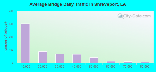
- 10,099,910Total average daily traffic
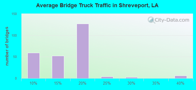
- 802,012Total average daily truck traffic
- National Bridge Inventory (NBI) Registered Bridges for Shreveport
- No street view available for this location
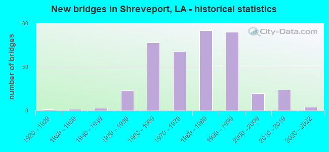
- New bridges - historical statistics
- 11920-1929
- 21930-1939
- 31940-1949
- 231950-1959
- 781960-1969
- 681970-1979
- 921980-1989
- 901990-1999
- 202000-2009
- 242010-2019
- 42020-2022
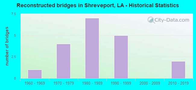
- Reconstructed bridges - Historical Statistics
- 11960-1969
- 41970-1979
- 71980-1989
- 51990-1999
- 02000-2009
- 22010-2019
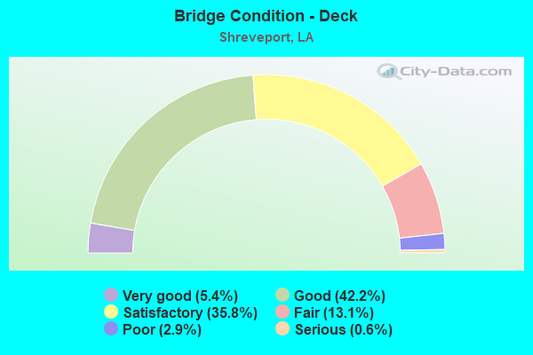
- Bridge Condition - Deck
- 5.4%Very good
- 42.2%Good
- 35.8%Satisfactory
- 13.1%Fair
- 2.9%Poor
- 0.6%Serious
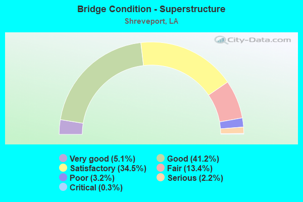
- Bridge Condition - Superstructure
- 5.1%Very good
- 41.2%Good
- 34.5%Satisfactory
- 13.4%Fair
- 3.2%Poor
- 2.2%Serious
- 0.3%Critical
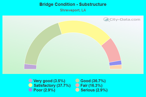
- Bridge Condition - Substructure
- 3.5%Very good
- 36.7%Good
- 37.7%Satisfactory
- 16.3%Fair
- 2.9%Poor
- 2.9%Serious
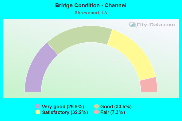
- Bridge Condition - Channel
- 26.9%Very good
- 33.5%Good
- 32.2%Satisfactory
- 7.3%Fair
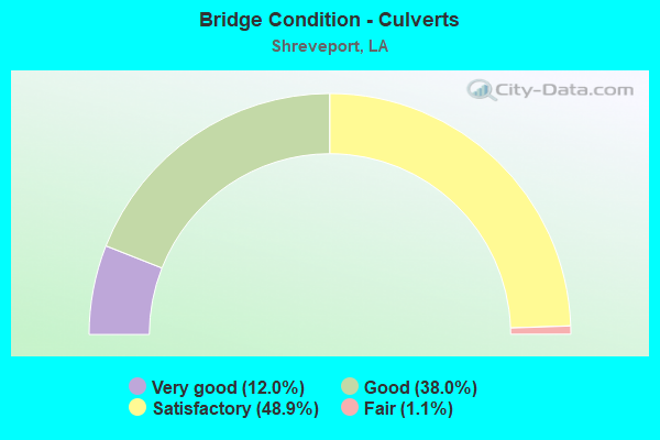
- Bridge Condition - Culverts
- 12.0%Very good
- 38.0%Good
- 48.9%Satisfactory
- 1.1%Fair
Find on map >> Show street view
Structure Number: 40904270102732, Location: 2.4 MI. W. OF US 171 (Lat: 32.419150, Lng: -93.829711), Route carried "on" structure: State highway 3132, Year Built: 1984, Status: Open, Structure Length: 10.36m (33.99ft), Average Daily Traffic: 23,800 (year 2016), Truck Traffic: 14%, Average Future Daily Traffic: 32,992 (year 2036), Design Load: HS 20, Features Intersected: T. & P. RR
Minimum Vertical Clearance: 30+ m (98+ ft), Kilometerpoint: 11.977, Lanes on structure: 2, Lanes under structure: 1, Base Highway Network: Yes (Inventory Route: 427-01-2, Subroute: 10), Owner: State Highway Agency, Approaching Roadway Width: 11.9m (39.0ft), Skew: 11 degrees, Material/Design: Prestressed concrete, Design/Construction: Stringer/Multi-beam, Number Of Spans In Main Unit: 4, Length of Maximum Span: 25.9m (85.0ft), Curb-To-Curb Width: 12.2m (40.0ft), Out-to-Out Width: 13.0m (42.7ft)
Condition: Deck: Good, Superstructure: Good, Substructure: Good, Operating Rating: 57.1 metric tons, Method Used To Determine Operating Rating: Load Factor (LF), Inventory Rating: 33.6 metric tons, Method Used To Determine Inventory Rating: Load Factor (LF), Structural Evaluation: Better than present minimum criteria, Deck Geometry: Better than present minimum criteria, Underclear: Better than present minimum criteria, Approach Roadway Alignment: Equal to present desirable criteria, Designated Inspection Frequency: Every 24 months, Inspection Date: January 2021, Deck Structure Type: Concrete Cast-file-Place
Find on map >> Show street view
Structure Number: 40904270102961, Location: 2.0 MI. E. OF LA 511 (Lat: 32.418050, Lng: -93.827311), Route carried "on" structure: State highway 3132, Year Built: 1984, Status: Open, Structure Length: 0.94m (3.08ft), Average Daily Traffic: 47,600 (year 2016), Truck Traffic: 14%, Average Future Daily Traffic: 54,988 (year 2036), Design Load: HS 20, Features Intersected: DRAIN
Minimum Vertical Clearance: 30+ m (98+ ft), Kilometerpoint: 4.806, Lanes on structure: 4, Base Highway Network: Yes (Inventory Route: 427-01-1, Subroute: 10), Owner: State Highway Agency, Approaching Roadway Width: 40.2m (131.9ft), Skew: 10 degrees, Material/Design: Concrete, Design/Construction: Culvert, Number Of Spans In Main Unit: 4, Length of Maximum Span: 2.1m (6.9ft)
Condition: Channel: Fair, Culverts: Satisfactory, Operating Rating: 42.1 metric tons, Method Used To Determine Operating Rating: Load and Resistance Factor Rating (LRFR) rating reported by rating factor(RF) method using HL-93 loadings, Inventory Rating: 32.4 metric tons, Method Used To Determine Inventory Rating: Load and Resistance Factor Rating (LRFR) rating reported by rating factor(RF) method using HL-93 loadings, Structural Evaluation: Equal to present minimum criteria, Waterway Adequacy: Equal to present desirable criteria, Approach Roadway Alignment: Equal to present desirable criteria, Designated Inspection Frequency: Every 24 months, Inspection Date: January 2021, Deck Structure Type: Concrete Cast-file-Place
Find on map >> Show street view
Structure Number: 40904270103681, Location: 2.7 MI. E. OF LA 511 (Lat: 32.417200, Lng: -93.815089), Route carried "on" structure: State highway 3132, Year Built: 1990, Status: Open, Structure Length: 6.61m (21.69ft), Average Daily Traffic: 23,800 (year 2016), Truck Traffic: 14%, Average Future Daily Traffic: 32,992 (year 2036), Design Load: HS 20, Features Intersected: LA 3132, WALKER ROAD
Minimum Vertical Clearance: 30+ m (98+ ft), Kilometerpoint: 5.937, Lanes on structure: 2, Lanes under structure: 4, Base Highway Network: Yes (Inventory Route: 427-01-1, Subroute: 10), Owner: State Highway Agency, Approaching Roadway Width: 11.9m (39.0ft), Skew: 10 degrees, Material/Design: Prestressed concrete, Design/Construction: Stringer/Multi-beam, Number Of Spans In Main Unit: 1, Number Of Approach Spans: 2, Length of Maximum Span: 33.2m (108.9ft), Curb-To-Curb Width: 12.2m (40.0ft), Out-to-Out Width: 13.0m (42.7ft)
Condition: Deck: Good, Superstructure: Good, Substructure: Good, Operating Rating: 64.4 metric tons, Method Used To Determine Operating Rating: Load Factor (LF), Inventory Rating: 31.7 metric tons, Method Used To Determine Inventory Rating: Load Factor (LF), Structural Evaluation: Better than present minimum criteria, Deck Geometry: Better than present minimum criteria, Underclear: Superior to present desirable criteria, Approach Roadway Alignment: Equal to present desirable criteria, Designated Inspection Frequency: Every 24 months, Inspection Date: Febuary 2022, Deck Structure Type: Concrete Cast-file-Place
Find on map >> Show street view
Structure Number: 40904270103682, Location: 1.5 MI. W. OF US 171 (Lat: 32.417439, Lng: -93.814381), Route carried "on" structure: State highway 3132, Year Built: 1990, Status: Open, Structure Length: 6.61m (21.69ft), Average Daily Traffic: 23,800 (year 2016), Truck Traffic: 14%, Average Future Daily Traffic: 32,992 (year 2036), Design Load: HS 20, Features Intersected: LA 3132, WALKER ROAD
Minimum Vertical Clearance: 30+ m (98+ ft), Kilometerpoint: 10.495, Lanes on structure: 2, Lanes under structure: 4, Base Highway Network: Yes (Inventory Route: 427-01-2, Subroute: 10), Owner: State Highway Agency, Approaching Roadway Width: 11.9m (39.0ft), Skew: 10 degrees, Material/Design: Prestressed concrete, Design/Construction: Stringer/Multi-beam, Number Of Spans In Main Unit: 1, Number Of Approach Spans: 2, Length of Maximum Span: 33.2m (108.9ft), Curb-To-Curb Width: 12.2m (40.0ft), Out-to-Out Width: 13.0m (42.7ft)
Condition: Deck: Good, Superstructure: Good, Substructure: Good, Operating Rating: 64.4 metric tons, Method Used To Determine Operating Rating: Load Factor (LF), Inventory Rating: 31.7 metric tons, Method Used To Determine Inventory Rating: Load Factor (LF), Structural Evaluation: Better than present minimum criteria, Deck Geometry: Better than present minimum criteria, Underclear: Better than present minimum criteria, Approach Roadway Alignment: Equal to present desirable criteria, Designated Inspection Frequency: Every 24 months, Inspection Date: Febuary 2022, Deck Structure Type: Concrete Cast-file-Place
Find on map >> Show street view
Structure Number: 40904270104691, Location: 3.7 MI. E. OF LA 511 (Lat: 32.417119, Lng: -93.797800), Route carried "on" structure: State highway 3132, Year Built: 1991, Status: Open, Structure Length: 6.61m (21.69ft), Average Daily Traffic: 23,800 (year 2016), Truck Traffic: 14%, Average Future Daily Traffic: 32,992 (year 2036), Design Load: HS 20, Features Intersected: JEWELLA AVE
Minimum Vertical Clearance: 30+ m (98+ ft), Kilometerpoint: 7.567, Lanes on structure: 2, Lanes under structure: 4, Base Highway Network: Yes (Inventory Route: 427-01-1, Subroute: 10), Owner: State Highway Agency, Approaching Roadway Width: 12.2m (40.0ft), Skew: 10 degrees, Material/Design: Prestressed concrete, Design/Construction: Stringer/Multi-beam, Number Of Spans In Main Unit: 3, Length of Maximum Span: 33.2m (108.9ft), Curb-To-Curb Width: 12.3m (40.4ft), Out-to-Out Width: 13.0m (42.7ft)
Condition: Deck: Good, Superstructure: Good, Substructure: Satisfactory, Operating Rating: 65.3 metric tons, Method Used To Determine Operating Rating: Load Factor (LF), Inventory Rating: 39.0 metric tons, Method Used To Determine Inventory Rating: Load Factor (LF), Structural Evaluation: Equal to present minimum criteria, Deck Geometry: Better than present minimum criteria, Underclear: Superior to present desirable criteria, Approach Roadway Alignment: Equal to present desirable criteria, Designated Inspection Frequency: Every 24 months, Inspection Date: Febuary 2021, Deck Structure Type: Concrete Cast-file-Place
Find on map >> Show street view
Structure Number: 40904270104692, Location: 3.2 MI. W. OF I-49 (Lat: 32.417361, Lng: -93.797039), Route carried "on" structure: State highway 3132, Year Built: 1991, Status: Open, Structure Length: 6.61m (21.69ft), Average Daily Traffic: 23,800 (year 2016), Truck Traffic: 14%, Average Future Daily Traffic: 32,992 (year 2036), Design Load: HS 20, Features Intersected: JEWELLA AVE
Minimum Vertical Clearance: 30+ m (98+ ft), Kilometerpoint: 8.866, Lanes on structure: 2, Lanes under structure: 4, Base Highway Network: Yes (Inventory Route: 427-01-2, Subroute: 10), Owner: State Highway Agency, Approaching Roadway Width: 12.2m (40.0ft), Skew: 10 degrees, Material/Design: Prestressed concrete, Design/Construction: Stringer/Multi-beam, Number Of Spans In Main Unit: 3, Length of Maximum Span: 33.2m (108.9ft), Curb-To-Curb Width: 12.3m (40.4ft), Out-to-Out Width: 13.0m (42.7ft)
Condition: Deck: Good, Superstructure: Good, Substructure: Satisfactory, Operating Rating: 65.3 metric tons, Method Used To Determine Operating Rating: Load Factor (LF), Inventory Rating: 39.0 metric tons, Method Used To Determine Inventory Rating: Load Factor (LF), Structural Evaluation: Equal to present minimum criteria, Deck Geometry: Better than present minimum criteria, Approach Roadway Alignment: Equal to present desirable criteria, Designated Inspection Frequency: Every 24 months, Inspection Date: Febuary 2021, Deck Structure Type: Concrete Cast-file-Place
Find on map >> Show street view
Structure Number: 40904270105141, Location: 4.2 MI. E. OF LA 511 (Lat: 32.415900, Lng: -93.790300), Route carried "on" structure: State highway 3132, Year Built: 1979, Status: Open, Structure Length: 20.48m (67.19ft), Average Daily Traffic: 47,600 (year 2016), Truck Traffic: 14%, Average Future Daily Traffic: 32,992 (year 2036), Design Load: HS 20, Features Intersected: US171,SPRR
Minimum Vertical Clearance: 30+ m (98+ ft), Kilometerpoint: 8.290, Lanes on structure: 2, Lanes under structure: 4, Base Highway Network: Yes (Inventory Route: 427-01-1, Subroute: 10), Owner: State Highway Agency, Approaching Roadway Width: 14.9m (48.9ft), Skew: 19 degrees, Material/Design: Prestressed concrete, Design/Construction: Stringer/Multi-beam, Number Of Spans In Main Unit: 10, Length of Maximum Span: 25.0m (82.0ft), Curb-To-Curb Width: 12.2m (40.0ft), Out-to-Out Width: 13.0m (42.7ft)
Condition: Deck: Good, Superstructure: Good, Substructure: Good, Operating Rating: 84.4 metric tons, Method Used To Determine Operating Rating: Load Factor (LF), Inventory Rating: 38.1 metric tons, Method Used To Determine Inventory Rating: Load Factor (LF), Structural Evaluation: Better than present minimum criteria, Deck Geometry: Somewhat better than minimum adequacy, Underclear: Better than present minimum criteria, Approach Roadway Alignment: Equal to present desirable criteria, Designated Inspection Frequency: Every 24 months, Inspection Date: January 2021, Deck Structure Type: Concrete Cast-file-Place
Find on map >> Show street view
Structure Number: 40904270105142, Location: 2.6 MI. W. OF I-49 (Lat: 32.415650, Lng: -93.788000), Route carried "on" structure: State highway 3132, Year Built: 1978, Status: Open, Structure Length: 19.48m (63.91ft), Average Daily Traffic: 47,600 (year 2016), Truck Traffic: 14%, Average Future Daily Traffic: 32,992 (year 2036), Design Load: HS 20, Features Intersected: US171,SPRR
Minimum Vertical Clearance: 30+ m (98+ ft), Kilometerpoint: 7.998, Lanes on structure: 2, Lanes under structure: 4, Base Highway Network: Yes (Inventory Route: 427-01-2, Subroute: 10), Owner: State Highway Agency, Approaching Roadway Width: 13.1m (43.0ft), Skew: 19 degrees, Material/Design: Prestressed concrete, Design/Construction: Stringer/Multi-beam, Number Of Spans In Main Unit: 9, Length of Maximum Span: 24.4m (80.1ft), Curb-To-Curb Width: 14.2m (46.6ft), Out-to-Out Width: 15.0m (49.2ft)
Condition: Deck: Good, Superstructure: Good, Substructure: Good, Operating Rating: 60.8 metric tons, Method Used To Determine Operating Rating: Load Factor (LF), Inventory Rating: 33.6 metric tons, Method Used To Determine Inventory Rating: Load Factor (LF), Structural Evaluation: Better than present minimum criteria, Deck Geometry: Superior to present desirable criteria, Underclear: Better than present minimum criteria, Approach Roadway Alignment: Better than present minimum criteria, Designated Inspection Frequency: Every 24 months, Inspection Date: January 2021, Deck Structure Type: Concrete Cast-file-Place
Find on map >> Show street view
Structure Number: 40904270105195, Location: 0.1 MI. E. OF US 171 (Lat: 32.414650, Lng: -93.789100), Route carried "on" structure: Ramp State highway 3132, Year Built: 1979, Status: Open, Structure Length: 8.26m (27.10ft), Average Daily Traffic: 1,770 (year 2016), Truck Traffic: 8%, Average Future Daily Traffic: 2,088 (year 2036), Design Load: HS 20, Features Intersected: SPRR
Minimum Vertical Clearance: 30+ m (98+ ft), Kilometerpoint: 0.140, Lanes on structure: 1, Owner: State Highway Agency, Approaching Roadway Width: 7.6m (24.9ft), Skew: 6 degrees, Material/Design: Prestressed concrete, Design/Construction: Stringer/Multi-beam, Number Of Spans In Main Unit: 5, Length of Maximum Span: 19.2m (63.0ft), Curb-To-Curb Width: 7.6m (24.9ft), Out-to-Out Width: 8.5m (27.9ft)
Condition: Deck: Good, Superstructure: Good, Substructure: Good, Operating Rating: 79.8 metric tons, Method Used To Determine Operating Rating: Load Factor (LF), Inventory Rating: 39.9 metric tons, Method Used To Determine Inventory Rating: Load Factor (LF), Structural Evaluation: Better than present minimum criteria, Deck Geometry: Better than present minimum criteria, Underclear: Better than present minimum criteria, Approach Roadway Alignment: Equal to present minimum criteria, Designated Inspection Frequency: Every 24 months, Inspection Date: January 2021, Deck Structure Type: Concrete Cast-file-Place
Find on map >> Show street view
Structure Number: 40904270105761, Location: 1.1 MI. N. OF LA 526 (Lat: 32.417431, Lng: -93.780250), Route carried "on" structure: County highway , Year Built: 1978, Status: Open, Structure Length: 10.18m (33.40ft), Average Daily Traffic: 4,660 (year 2015), Average Future Daily Traffic: 5,498 (year 2036), Design Load: HS 20, Features Intersected: LA 3132, Facility Carried by Structure: KINGSTON RD
Minimum Vertical Clearance: 30+ m (98+ ft), Kilometerpoint: 9.297, Lanes on structure: 2, Lanes under structure: 4, Owner: State Highway Agency, Approaching Roadway Width: 15.5m (50.9ft), Skew: 5 degrees, Material/Design: Prestressed concrete, Design/Construction: Stringer/Multi-beam, Number Of Spans In Main Unit: 4, Length of Maximum Span: 31.1m (102.0ft), Curb or Sidewalk Widths: Left: 1.2m (3.9ft), Right: 1.2m (3.9ft), Curb-To-Curb Width: 15.6m (51.2ft), Out-to-Out Width: 18.7m (61.4ft)
Condition: Deck: Good, Superstructure: Good, Substructure: Good, Operating Rating: 67.1 metric tons, Method Used To Determine Operating Rating: Load Factor (LF), Inventory Rating: 34.5 metric tons, Method Used To Determine Inventory Rating: Load Factor (LF), Structural Evaluation: Better than present minimum criteria, Deck Geometry: Superior to present desirable criteria, Underclear: Somewhat better than minimum adequacy, Approach Roadway Alignment: Equal to present desirable criteria, Designated Inspection Frequency: Every 24 months, Inspection Date: January 2021, Deck Structure Type: Concrete Cast-file-Place
Find on map >> Show street view
Structure Number: 40904270106331, Location: 1.1 MI. E. OF US 171 (Lat: 32.420350, Lng: -93.771531), Route carried "on" structure: State highway 3132, Year Built: 1979, Status: Open, Structure Length: 5.49m (18.01ft), Average Daily Traffic: 47,600 (year 2016), Truck Traffic: 14%, Average Future Daily Traffic: 32,992 (year 2036), Design Load: HS 20, Features Intersected: BRUSH BAYOU
Minimum Vertical Clearance: 30+ m (98+ ft), Kilometerpoint: 10.189, Lanes on structure: 2, Base Highway Network: Yes (Inventory Route: 427-01-1, Subroute: 10), Owner: State Highway Agency, Approaching Roadway Width: 11.6m (38.1ft), Skew: 10 degrees, Material/Design: Prestressed concrete, Design/Construction: Stringer/Multi-beam, Number Of Spans In Main Unit: 3, Length of Maximum Span: 18.3m (60.0ft), Curb-To-Curb Width: 12.3m (40.4ft), Out-to-Out Width: 13.0m (42.7ft)
Condition: Deck: Good, Superstructure: Good, Substructure: Satisfactory, Channel: Satisfactory, Operating Rating: 79.8 metric tons, Method Used To Determine Operating Rating: Load Factor (LF), Inventory Rating: 37.2 metric tons, Method Used To Determine Inventory Rating: Load Factor (LF), Structural Evaluation: Equal to present minimum criteria, Deck Geometry: Somewhat better than minimum adequacy, Waterway Adequacy: Equal to present desirable criteria, Approach Roadway Alignment: Equal to present desirable criteria, Designated Inspection Frequency: Every 24 months, Inspection Date: Febuary 2021, Deck Structure Type: Concrete Cast-file-Place
Find on map >> Show street view
Structure Number: 40904270106332, Location: 1.5 MI. W. OF I-49 (Lat: 32.420661, Lng: -93.770850), Route carried "on" structure: State highway 3132, Year Built: 1979, Status: Open, Structure Length: 5.49m (18.01ft), Average Daily Traffic: 47,600 (year 2016), Truck Traffic: 14%, Average Future Daily Traffic: 32,992 (year 2036), Design Load: HS 20, Features Intersected: BRUSH BAYOU
Minimum Vertical Clearance: 30+ m (98+ ft), Kilometerpoint: 6.251, Lanes on structure: 2, Base Highway Network: Yes (Inventory Route: 427-01-2, Subroute: 10), Owner: State Highway Agency, Approaching Roadway Width: 11.6m (38.1ft), Skew: 10 degrees, Material/Design: Prestressed concrete, Design/Construction: Stringer/Multi-beam, Number Of Spans In Main Unit: 3, Length of Maximum Span: 18.3m (60.0ft), Curb-To-Curb Width: 12.3m (40.4ft), Out-to-Out Width: 13.0m (42.7ft)
Condition: Deck: Good, Superstructure: Good, Substructure: Satisfactory, Channel: Very good, Operating Rating: 78.9 metric tons, Method Used To Determine Operating Rating: Load Factor (LF), Inventory Rating: 33.6 metric tons, Method Used To Determine Inventory Rating: Load Factor (LF), Structural Evaluation: Equal to present minimum criteria, Deck Geometry: Somewhat better than minimum adequacy, Waterway Adequacy: Equal to present desirable criteria, Approach Roadway Alignment: Equal to present desirable criteria, Designated Inspection Frequency: Every 24 months, Inspection Date: Febuary 2021, Deck Structure Type: Concrete Cast-file-Place
Find on map >> Show street view
Structure Number: 40904270106791, Location: 1.61 MI. E. OF US 171 (Lat: 32.420411, Lng: -93.763500), Route carried "on" structure: State highway 3132, Year Built: 1988, Status: Open, Structure Length: 6.68m (21.92ft), Average Daily Traffic: 47,600 (year 2016), Truck Traffic: 14%, Average Future Daily Traffic: 32,992 (year 2036), Design Load: HS 20, Features Intersected: LINWOOD AVE.
Minimum Vertical Clearance: 30+ m (98+ ft), Kilometerpoint: 10.945, Lanes on structure: 2, Lanes under structure: 4, Base Highway Network: Yes (Inventory Route: 427-01-1, Subroute: 10), Owner: State Highway Agency, Approaching Roadway Width: 11.9m (39.0ft), Skew: 10 degrees, Material/Design: Prestressed concrete, Design/Construction: Stringer/Multi-beam, Number Of Spans In Main Unit: 3, Length of Maximum Span: 33.2m (108.9ft), Curb-To-Curb Width: 12.2m (40.0ft), Out-to-Out Width: 13.0m (42.7ft)
Condition: Deck: Good, Superstructure: Good, Substructure: Good, Operating Rating: 65.3 metric tons, Method Used To Determine Operating Rating: Load Factor (LF), Inventory Rating: 39.0 metric tons, Method Used To Determine Inventory Rating: Load Factor (LF), Structural Evaluation: Better than present minimum criteria, Deck Geometry: Somewhat better than minimum adequacy, Underclear: Superior to present desirable criteria, Approach Roadway Alignment: Equal to present desirable criteria, Designated Inspection Frequency: Every 24 months, Inspection Date: Febuary 2022, Deck Structure Type: Concrete Cast-file-Place
Find on map >> Show street view
Structure Number: 40904270106792, Location: 0.8 MI. W. OF I-49 (Lat: 32.420669, Lng: -93.762789), Route carried "on" structure: State highway 3132, Year Built: 1988, Status: Open, Structure Length: 6.68m (21.92ft), Average Daily Traffic: 47,600 (year 2016), Truck Traffic: 14%, Average Future Daily Traffic: 32,992 (year 2036), Design Load: HS 20, Features Intersected: LINWOOD AVE.
Minimum Vertical Clearance: 30+ m (98+ ft), Kilometerpoint: 5.486, Lanes on structure: 2, Lanes under structure: 4, Base Highway Network: Yes (Inventory Route: 427-01-2, Subroute: 10), Owner: State Highway Agency, Approaching Roadway Width: 15.2m (49.9ft), Skew: 10 degrees, Material/Design: Prestressed concrete, Design/Construction: Stringer/Multi-beam, Number Of Spans In Main Unit: 3, Length of Maximum Span: 33.2m (108.9ft), Curb-To-Curb Width: 15.9m (52.2ft), Out-to-Out Width: 16.7m (54.8ft)
Condition: Deck: Good, Superstructure: Good, Substructure: Good, Operating Rating: 65.3 metric tons, Method Used To Determine Operating Rating: Load Factor (LF), Inventory Rating: 39.0 metric tons, Method Used To Determine Inventory Rating: Load Factor (LF), Structural Evaluation: Better than present minimum criteria, Deck Geometry: Superior to present desirable criteria, Underclear: Superior to present desirable criteria, Approach Roadway Alignment: Equal to present desirable criteria, Designated Inspection Frequency: Every 24 months, Inspection Date: Febuary 2022, Deck Structure Type: Other
Find on map >> Show street view
Structure Number: 40904270107351, Location: 1.7 MI. N. OF LA 526 (Lat: 32.418989, Lng: -93.752669), Route carried "on" structure: City street , Year Built: 1991, Status: Open, Structure Length: 24.72m (81.10ft), Average Daily Traffic: 4,230 (year 2015), Average Future Daily Traffic: 4,991 (year 2036), Design Load: HS 20, Features Intersected: LA 3132, Facility Carried by Structure: ST VINCENT AVE
Minimum Vertical Clearance: 30+ m (98+ ft), Kilometerpoint: 11.840, Lanes on structure: 4, Lanes under structure: 5, Owner: State Highway Agency, Approaching Roadway Width: 15.9m (52.2ft), Skew: 24 degrees, Material/Design: Steel continuous, Design/Construction: Girder and Floorbeam System, Number Of Spans In Main Unit: 5, Length of Maximum Span: 58.8m (192.9ft), Curb or Sidewalk Widths: Left: 1.5m (4.9ft), Right: 1.5m (4.9ft), Curb-To-Curb Width: 17.0m (55.8ft), Out-to-Out Width: 20.8m (68.2ft)
Condition: Deck: Good, Superstructure: Good, Substructure: Good, Operating Rating: 59.0 metric tons, Method Used To Determine Operating Rating: Load Factor (LF), Inventory Rating: 35.4 metric tons, Method Used To Determine Inventory Rating: Load Factor (LF), Structural Evaluation: Better than present minimum criteria, Deck Geometry: Somewhat better than minimum adequacy, Underclear: Better than present minimum criteria, Approach Roadway Alignment: Better than present minimum criteria, Designated Inspection Frequency: Every 24 months, Inspection Date: Febuary 2021, Deck Structure Type: Concrete Cast-file-Place
Find on map >> Show street view
Structure Number: 40904270107781, Location: 2.7 MI. E. OF US 171 (Lat: 32.418569, Lng: -93.746900), Route carried "on" structure: State highway 3132, Year Built: 1977, Status: Open, Structure Length: 11.80m (38.71ft), Average Daily Traffic: 43,700 (year 2016), Truck Traffic: 14%, Average Future Daily Traffic: 29,948 (year 2036), Design Load: HS 20, Features Intersected: KCS RR
Minimum Vertical Clearance: 30+ m (98+ ft), Kilometerpoint: 12.526, Lanes on structure: 2, Base Highway Network: Yes (Inventory Route: 427-01-1, Subroute: 10), Owner: State Highway Agency, Approaching Roadway Width: 11.9m (39.0ft), Skew: 13 degrees, Material/Design: Prestressed concrete, Design/Construction: Stringer/Multi-beam, Number Of Spans In Main Unit: 8, Length of Maximum Span: 31.1m (102.0ft), Curb-To-Curb Width: 12.3m (40.4ft), Out-to-Out Width: 13.2m (43.3ft)
Condition: Deck: Satisfactory, Superstructure: Satisfactory, Substructure: Satisfactory, Operating Rating: 70.7 metric tons, Method Used To Determine Operating Rating: Load Factor (LF), Inventory Rating: 35.4 metric tons, Method Used To Determine Inventory Rating: Load Factor (LF), Structural Evaluation: Equal to present minimum criteria, Deck Geometry: Somewhat better than minimum adequacy, Underclear: Equal to present minimum criteria, Approach Roadway Alignment: Equal to present desirable criteria, Designated Inspection Frequency: Every 24 months, Inspection Date: Febuary 2022, Deck Structure Type: Concrete Cast-file-Place
Find on map >> Show street view
Structure Number: 40904270107782, Location: 0.5 MI. W. OF LA 523 (Lat: 32.418661, Lng: -93.745789), Route carried "on" structure: State highway 3132, Year Built: 1977, Status: Open, Structure Length: 11.80m (38.71ft), Average Daily Traffic: 43,700 (year 2016), Truck Traffic: 14%, Average Future Daily Traffic: 29,948 (year 2036), Design Load: HS 20, Features Intersected: KCS RR
Minimum Vertical Clearance: 30+ m (98+ ft), Kilometerpoint: 3.875, Lanes on structure: 2, Base Highway Network: Yes (Inventory Route: 427-01-2, Subroute: 10), Owner: State Highway Agency, Approaching Roadway Width: 11.9m (39.0ft), Skew: 13 degrees, Material/Design: Prestressed concrete, Design/Construction: Stringer/Multi-beam, Number Of Spans In Main Unit: 8, Length of Maximum Span: 31.1m (102.0ft), Curb-To-Curb Width: 12.3m (40.4ft), Out-to-Out Width: 13.2m (43.3ft)
Condition: Deck: Satisfactory, Superstructure: Satisfactory, Substructure: Fair, Operating Rating: 70.7 metric tons, Method Used To Determine Operating Rating: Load Factor (LF), Inventory Rating: 35.4 metric tons, Method Used To Determine Inventory Rating: Load Factor (LF), Structural Evaluation: Somewhat better than minimum adequacy, Deck Geometry: Somewhat better than minimum adequacy, Underclear: Equal to present minimum criteria, Approach Roadway Alignment: Equal to present desirable criteria, Designated Inspection Frequency: Every 24 months, Inspection Date: Febuary 2022, Deck Structure Type: Concrete Cast-file-Place
Find on map >> Show street view
Structure Number: 40904270108361, Location: 1.1 MI. E. OF I-49 (Lat: 32.415919, Lng: -93.737781), Route carried "on" structure: State highway 3132, Year Built: 1995, Status: Open, Structure Length: 6.58m (21.59ft), Average Daily Traffic: 21,850 (year 2016), Truck Traffic: 14%, Average Future Daily Traffic: 29,948 (year 2036), Design Load: HS 20, Features Intersected: LA 523
Minimum Vertical Clearance: 30+ m (98+ ft), Kilometerpoint: 13.432, Lanes on structure: 3, Lanes under structure: 6, Base Highway Network: Yes (Inventory Route: 427-01-1, Subroute: 10), Owner: State Highway Agency, Approaching Roadway Width: 15.5m (50.9ft), Skew: 10 degrees, Material/Design: Prestressed concrete, Design/Construction: Stringer/Multi-beam, Number Of Spans In Main Unit: 3, Length of Maximum Span: 32.9m (107.9ft), Curb-To-Curb Width: 15.8m (51.8ft), Out-to-Out Width: 16.8m (55.1ft)
Condition: Deck: Good, Superstructure: Good, Substructure: Satisfactory, Operating Rating: 76.2 metric tons, Method Used To Determine Operating Rating: Load Factor (LF), Inventory Rating: 42.6 metric tons, Method Used To Determine Inventory Rating: Load Factor (LF), Structural Evaluation: Equal to present minimum criteria, Deck Geometry: Somewhat better than minimum adequacy, Approach Roadway Alignment: Equal to present desirable criteria, Designated Inspection Frequency: Every 24 months, Inspection Date: Febuary 2021, Deck Structure Type: Concrete Cast-file-Place
Find on map >> Show street view
Structure Number: 40904270108362, Location: 0.8 MI. W. OF LA 526 (Lat: 32.415919, Lng: -93.737000), Route carried "on" structure: State highway 3132, Year Built: 1995, Status: Open, Structure Length: 6.58m (21.59ft), Average Daily Traffic: 21,850 (year 2016), Truck Traffic: 14%, Average Future Daily Traffic: 29,948 (year 2036), Design Load: HS 20, Features Intersected: LA 523
Minimum Vertical Clearance: 30+ m (98+ ft), Kilometerpoint: 2.993, Lanes on structure: 2, Lanes under structure: 6, Base Highway Network: Yes (Inventory Route: 427-01-2, Subroute: 10), Owner: State Highway Agency, Approaching Roadway Width: 15.5m (50.9ft), Skew: 10 degrees, Material/Design: Prestressed concrete, Design/Construction: Stringer/Multi-beam, Number Of Spans In Main Unit: 3, Length of Maximum Span: 32.9m (107.9ft), Curb-To-Curb Width: 12.1m (39.7ft), Out-to-Out Width: 13.1m (43.0ft)
Condition: Deck: Good, Superstructure: Good, Substructure: Satisfactory, Operating Rating: 76.2 metric tons, Method Used To Determine Operating Rating: Load Factor (LF), Inventory Rating: 42.6 metric tons, Method Used To Determine Inventory Rating: Load Factor (LF), Structural Evaluation: Equal to present minimum criteria, Deck Geometry: Equal to present minimum criteria, Underclear: High priority of corrective action, Approach Roadway Alignment: Equal to present desirable criteria, Designated Inspection Frequency: Every 24 months, Inspection Date: Febuary 2021, Deck Structure Type: Concrete Cast-file-Place
Find on map >> Show street view
Structure Number: 40904270108921, Location: 0.6 MI. E. OF LA 523 (Lat: 32.412861, Lng: -93.728961), Route carried "on" structure: State highway 3132, Year Built: 1977, Status: Open, Structure Length: 7.07m (23.20ft), Average Daily Traffic: 43,700 (year 2016), Truck Traffic: 14%, Average Future Daily Traffic: 29,948 (year 2036), Design Load: HS 20, Features Intersected: BAYOU PIERRE
Minimum Vertical Clearance: 30+ m (98+ ft), Kilometerpoint: 14.341, Lanes on structure: 2, Base Highway Network: Yes (Inventory Route: 427-01-1, Subroute: 10), Owner: State Highway Agency, Approaching Roadway Width: 15.2m (49.9ft), Skew: 17 degrees, Material/Design: Prestressed concrete, Design/Construction: Stringer/Multi-beam, Number Of Spans In Main Unit: 4, Length of Maximum Span: 17.7m (58.1ft), Curb-To-Curb Width: 8.5m (27.9ft), Out-to-Out Width: 16.8m (55.1ft)
Condition: Deck: Good, Superstructure: Good, Substructure: Satisfactory, Channel: Very good, Operating Rating: 77.1 metric tons, Method Used To Determine Operating Rating: Load Factor (LF), Inventory Rating: 33.6 metric tons, Method Used To Determine Inventory Rating: Load Factor (LF), Structural Evaluation: Equal to present minimum criteria, Deck Geometry: Meets minimum limits, Waterway Adequacy: Equal to present desirable criteria, Approach Roadway Alignment: Equal to present desirable criteria, Designated Inspection Frequency: Every 24 months, Inspection Date: Febuary 2021, Deck Structure Type: Concrete Cast-file-Place
Find on map >> Show street view
Structure Number: 40904270108922, Location: 0.2 MI. W. OF LA 526 (Lat: 32.412811, Lng: -93.728000), Route carried "on" structure: State highway 3132, Year Built: 1977, Status: Open, Structure Length: 7.07m (23.20ft), Average Daily Traffic: 43,700 (year 2016), Truck Traffic: 14%, Average Future Daily Traffic: 29,948 (year 2036), Design Load: HS 20, Features Intersected: BAYOU PIERRE
Minimum Vertical Clearance: 30+ m (98+ ft), Kilometerpoint: 2.082, Lanes on structure: 2, Base Highway Network: Yes (Inventory Route: 427-01-2, Subroute: 10), Owner: State Highway Agency, Approaching Roadway Width: 15.2m (49.9ft), Skew: 17 degrees, Material/Design: Prestressed concrete, Design/Construction: Stringer/Multi-beam, Number Of Spans In Main Unit: 4, Length of Maximum Span: 17.7m (58.1ft), Curb-To-Curb Width: 15.9m (52.2ft), Out-to-Out Width: 16.8m (55.1ft)
Condition: Deck: Good, Superstructure: Good, Substructure: Satisfactory, Channel: Satisfactory, Operating Rating: 76.2 metric tons, Method Used To Determine Operating Rating: Load Factor (LF), Inventory Rating: 34.5 metric tons, Method Used To Determine Inventory Rating: Load Factor (LF), Structural Evaluation: Equal to present minimum criteria, Deck Geometry: Superior to present desirable criteria, Waterway Adequacy: Equal to present desirable criteria, Approach Roadway Alignment: Equal to present desirable criteria, Designated Inspection Frequency: Every 24 months, Inspection Date: Febuary 2021, Deck Structure Type: Concrete Cast-file-Place
Find on map >> Show street view
Structure Number: 40904270109081, Location: 0.7 MI. E. OF LA 523 (Lat: 32.411981, Lng: -93.726400), Route carried "on" structure: State highway 3132, Year Built: 2007, Status: Open, Structure Length: 19.99m (65.58ft), Average Daily Traffic: 21,850 (year 2016), Truck Traffic: 14%, Average Future Daily Traffic: 29,948 (year 2036), Design Load: HS 20, Features Intersected: LA 526 BERT KOUNS IND. L
Minimum Vertical Clearance: 30+ m (98+ ft), Kilometerpoint: 14.597, Lanes on structure: 2, Lanes under structure: 5, Base Highway Network: Yes (Inventory Route: 427-01-1, Subroute: 10), Owner: State Highway Agency, Approaching Roadway Width: 11.6m (38.1ft), Skew: 30 degrees, Material/Design: Prestressed concrete, Design/Construction: Stringer/Multi-beam, Number Of Spans In Main Unit: 1, Number Of Approach Spans: 8, Length of Maximum Span: 40.2m (131.9ft), Curb-To-Curb Width: 12.0m (39.4ft), Out-to-Out Width: 13.0m (42.7ft)
Condition: Deck: Very good, Superstructure: Very good, Substructure: Good, Operating Rating: 53.5 metric tons, Method Used To Determine Operating Rating: Load and Resistance Factor Rating (LRFR) rating reported by rating factor(RF) method using HL-93 loadings, Inventory Rating: 24.6 metric tons, Method Used To Determine Inventory Rating: Load and Resistance Factor Rating (LRFR) rating reported by rating factor(RF) method using HL-93 loadings, Structural Evaluation: Equal to present minimum criteria, Deck Geometry: Equal to present minimum criteria, Underclear: Superior to present desirable criteria, Approach Roadway Alignment: Equal to present desirable criteria, Designated Inspection Frequency: Every 24 months, Inspection Date: Febuary 2021, Deck Structure Type: Concrete Cast-file-Place, Wearing Surface/Protective System: Deck Protection: Epoxy Coated Reinforcing
Find on map >> Show street view
Structure Number: 40904270109082, Location: 1.1 MI. W. OF LA 526 (Lat: 32.411539, Lng: -93.724300), Route carried "on" structure: State highway 3132, Year Built: 2007, Status: Open, Structure Length: 19.99m (65.58ft), Average Daily Traffic: 21,850 (year 2016), Truck Traffic: 14%, Average Future Daily Traffic: 29,948 (year 2036), Design Load: HS 20, Features Intersected: LA 526 BERT KOUNS IND. L
Minimum Vertical Clearance: 30+ m (98+ ft), Kilometerpoint: 1.706, Lanes on structure: 2, Lanes under structure: 5, Base Highway Network: Yes (Inventory Route: 427-01-2, Subroute: 10), Owner: State Highway Agency, Approaching Roadway Width: 11.6m (38.1ft), Skew: 30 degrees, Material/Design: Prestressed concrete, Design/Construction: Stringer/Multi-beam, Number Of Spans In Main Unit: 1, Number Of Approach Spans: 8, Length of Maximum Span: 40.2m (131.9ft), Curb-To-Curb Width: 12.1m (39.7ft), Out-to-Out Width: 13.0m (42.7ft)
Condition: Deck: Very good, Superstructure: Very good, Substructure: Good, Operating Rating: 39.9 metric tons, Method Used To Determine Operating Rating: Load Factor (LF), Inventory Rating: 32.7 metric tons, Method Used To Determine Inventory Rating: Load Factor (LF), Structural Evaluation: Better than present minimum criteria, Deck Geometry: Equal to present minimum criteria, Underclear: Superior to present desirable criteria, Approach Roadway Alignment: Equal to present desirable criteria, Designated Inspection Frequency: Every 24 months, Inspection Date: Febuary 2021, Deck Structure Type: Concrete Cast-file-Place, Wearing Surface/Protective System: Deck Protection: Epoxy Coated Reinforcing
Find on map >> Show street view
Structure Number: 40904510100681, Location: 3.04 MI WEST OF LA 169 (Lat: 32.456161, Lng: -94.033000), Route carried "on" structure: Interstate 20, Year Built: 1964, Status: Open, Structure Length: 4.27m (14.01ft), Average Daily Traffic: 18,300 (year 2016), Truck Traffic: 36%, Average Future Daily Traffic: 25,558 (year 2036), Design Load: HS 20, Features Intersected: CROSS BAYOU
Minimum Vertical Clearance: 30+ m (98+ ft), Kilometerpoint: 1.090, Lanes on structure: 2, Base Highway Network: Yes (Inventory Route: 451-01-1, Subroute: 10), Owner: State Highway Agency, Approaching Roadway Width: 13.4m (44.0ft), Skew: 10 degrees, Material/Design: Concrete, Design/Construction: Slab, Number Of Spans In Main Unit: 7, Length of Maximum Span: 6.1m (20.0ft), Curb-To-Curb Width: 12.2m (40.0ft), Out-to-Out Width: 13.9m (45.6ft)
Condition: Deck: Fair, Superstructure: Fair, Substructure: Fair, Channel: Satisfactory, Operating Rating: 61.7 metric tons, Method Used To Determine Operating Rating: Load Factor (LF), Inventory Rating: 37.2 metric tons, Method Used To Determine Inventory Rating: Load Factor (LF), Structural Evaluation: Somewhat better than minimum adequacy, Deck Geometry: Better than present minimum criteria, Waterway Adequacy: Equal to present desirable criteria, Approach Roadway Alignment: Equal to present desirable criteria, Designated Inspection Frequency: Every 24 months, Inspection Date: March 2020, Deck Structure Type: Concrete Cast-file-Place
Find on map >> Show street view
Structure Number: 40904510106282, Location: .6 MI EAST OF US80 (Lat: 32.443911, Lng: -93.937900), Route carried "on" structure: Interstate 20, Year Built: 1965, Status: Open, Structure Length: 12.56m (41.21ft), Average Daily Traffic: 25,600 (year 2018), Truck Traffic: 19%, Average Future Daily Traffic: 38,232 (year 2036), Design Load: HS 20, Features Intersected: M.P. RR
Minimum Vertical Clearance: 30+ m (98+ ft), Kilometerpoint: 20.973, Lanes on structure: 2, Base Highway Network: Yes (Inventory Route: 451-01-2, Subroute: 10), Owner: State Highway Agency, Approaching Roadway Width: 12.2m (40.0ft), Skew: 10 degrees, Material/Design: Steel, Design/Construction: Stringer/Multi-beam, Number Of Spans In Main Unit: 8, Length of Maximum Span: 16.8m (55.1ft), Curb-To-Curb Width: 8.6m (28.2ft), Out-to-Out Width: 10.2m (33.5ft)
Condition: Deck: Serious, Superstructure: Fair, Substructure: Fair, Operating Rating: 39.5 metric tons, Method Used To Determine Operating Rating: Load and Resistance Factor Rating (LRFR) rating reported by rating factor(RF) method using HL-93 loadings, Inventory Rating: 30.5 metric tons, Method Used To Determine Inventory Rating: Load and Resistance Factor Rating (LRFR) rating reported by rating factor(RF) method using HL-93 loadings, Structural Evaluation: Somewhat better than minimum adequacy, Deck Geometry: High priority of corrective action, Underclear: Meets minimum limits, Approach Roadway Alignment: Equal to present desirable criteria, Length Of Structure Improvement: 13.47m (44.19ft), Designated Inspection Frequency: Every 12 months, Critical Feature Inspection Frequency: Every 12 months, Inspection Date: June 2021, Critical Feature Inspection Date: June 2021, Bridge Improvement Cost: $1,149,000, Total Project Cost: $1,723,000 ( Estimate for 2016), Deck Structure Type: Concrete Cast-file-Place
Find on map >> Show street view
Structure Number: 40904510106311, Location: .6 MI EAST OF US 80 (Lat: 32.443639, Lng: -93.938600), Route carried "on" structure: Interstate 20, Year Built: 1965, Status: Open, Structure Length: 12.56m (41.21ft), Average Daily Traffic: 25,600 (year 2018), Truck Traffic: 19%, Average Future Daily Traffic: 38,232 (year 2036), Design Load: HS 20, Features Intersected: M.P. RR
Minimum Vertical Clearance: 30+ m (98+ ft), Kilometerpoint: 10.155, Lanes on structure: 2, Base Highway Network: Yes (Inventory Route: 451-01-1, Subroute: 10), Owner: State Highway Agency, Approaching Roadway Width: 12.2m (40.0ft), Skew: 10 degrees, Material/Design: Steel, Design/Construction: Stringer/Multi-beam, Number Of Spans In Main Unit: 8, Length of Maximum Span: 16.8m (55.1ft), Curb-To-Curb Width: 8.7m (28.5ft), Out-to-Out Width: 10.2m (33.5ft)
Condition: Deck: Poor, Superstructure: Poor, Substructure: Fair, Operating Rating: 36.0 metric tons, Method Used To Determine Operating Rating: Load and Resistance Factor Rating (LRFR) rating reported by rating factor(RF) method using HL-93 loadings, Inventory Rating: 27.9 metric tons, Method Used To Determine Inventory Rating: Load and Resistance Factor Rating (LRFR) rating reported by rating factor(RF) method using HL-93 loadings, Structural Evaluation: Meets minimum limits, Deck Geometry: High priority of corrective action, Underclear: Meets minimum limits, Approach Roadway Alignment: Equal to present desirable criteria, Length Of Structure Improvement: 13.47m (44.19ft), Designated Inspection Frequency: Every 12 months, Critical Feature Inspection Frequency: Every 12 months, Inspection Date: June 2021, Critical Feature Inspection Date: June 2021, Bridge Improvement Cost: $1,149,000, Total Project Cost: $1,723,000 ( Estimate for 2016), Deck Structure Type: Concrete Cast-file-Place
Find on map >> Show street view
Structure Number: 40904510110601, Location: 1.9 MI EAST OF LA 526 (Lat: 32.450931, Lng: -93.865700), Route carried "on" structure: County highway , Year Built: 1977, Status: Open, Structure Length: 8.29m (27.20ft), Average Daily Traffic: 35,800 (year 2015), Average Future Daily Traffic: 42,244 (year 2036), Design Load: HS 20, Features Intersected: I-20, Facility Carried by Structure: PINES RD
Minimum Vertical Clearance: 30+ m (98+ ft), Kilometerpoint: 17.048, Lanes on structure: 6, Lanes under structure: 4, Base Highway Network: Yes (Inventory Route: 451-01-1, Subroute: 10), Owner: State Highway Agency, Approaching Roadway Width: 26.2m (86.0ft), Skew: 20 degrees, Material/Design: Prestressed concrete, Design/Construction: Stringer/Multi-beam, Number Of Spans In Main Unit: 4, Length of Maximum Span: 25.9m (85.0ft), Curb-To-Curb Width: 25.6m (84.0ft), Out-to-Out Width: 26.4m (86.6ft)
Condition: Deck: Satisfactory, Superstructure: Satisfactory, Substructure: Satisfactory, Operating Rating: 86.2 metric tons, Method Used To Determine Operating Rating: Load Factor (LF), Inventory Rating: 45.4 metric tons, Method Used To Determine Inventory Rating: Load Factor (LF), Structural Evaluation: Equal to present minimum criteria, Deck Geometry: Somewhat better than minimum adequacy, Underclear: Somewhat better than minimum adequacy, Approach Roadway Alignment: Equal to present desirable criteria, Designated Inspection Frequency: Every 24 months, Inspection Date: March 2020, Deck Structure Type: Concrete Cast-file-Place
Find on map >> Show street view
Structure Number: 40904510111687, Location: I-220 RAMPS OVER I-20 (Lat: 32.454731, Lng: -93.847889), Route carried "on" structure: Ramp Interstate 20, Year Built: 1985, Status: Open, Structure Length: 19.20m (62.99ft), Average Daily Traffic: 7,160 (year 2016), Truck Traffic: 19%, Average Future Daily Traffic: 8,448 (year 2036), Design Load: HS 20, Features Intersected: I-20 RAMP W-N OVER I-20
Minimum Vertical Clearance: 30+ m (98+ ft), Kilometerpoint: 0.286, Lanes on structure: 1, Lanes under structure: 5, Owner: State Highway Agency, Approaching Roadway Width: 7.9m (25.9ft), Material/Design: Steel continuous, Design/Construction: Stringer/Multi-beam, Number Of Spans In Main Unit: 1, Number Of Approach Spans: 4, Length of Maximum Span: 47.2m (154.9ft), Curb-To-Curb Width: 7.6m (24.9ft), Out-to-Out Width: 8.5m (27.9ft)
Condition: Deck: Satisfactory, Superstructure: Satisfactory, Substructure: Satisfactory, Operating Rating: 30.8 metric tons, Method Used To Determine Operating Rating: Load Factor (LF), Inventory Rating: 18.1 metric tons, Method Used To Determine Inventory Rating: Load Factor (LF), Structural Evaluation: Meets minimum limits, Deck Geometry: Better than present minimum criteria, Underclear: Superior to present desirable criteria, Approach Roadway Alignment: Equal to present minimum criteria, Designated Inspection Frequency: Every 24 months, Inspection Date: March 2020, Deck Structure Type: Concrete Cast-file-Place
Find on map >> Show street view
Structure Number: 40904510111816, Location: I-220 RAMPS OVER I-20 (Lat: 32.454311, Lng: -93.843000), Route carried "on" structure: Ramp Interstate 20, Year Built: 1980, Status: Open, Structure Length: 37.73m (123.79ft), Average Daily Traffic: 5,440 (year 2016), Truck Traffic: 19%, Average Future Daily Traffic: 6,419 (year 2036), Design Load: HS 20, Features Intersected: ON RAMP TO I-20 WBL
Minimum Vertical Clearance: 30+ m (98+ ft), Kilometerpoint: 0.486, Lanes on structure: 1, Lanes under structure: 8, Owner: State Highway Agency, Approaching Roadway Width: 7.6m (24.9ft), Skew: 4 degrees, Material/Design: Steel continuous, Design/Construction: Stringer/Multi-beam, Number Of Spans In Main Unit: 3, Length of Maximum Span: 133.5m (438.0ft), Curb-To-Curb Width: 7.6m (24.9ft), Out-to-Out Width: 8.5m (27.9ft)
Condition: Deck: Fair, Superstructure: Satisfactory, Substructure: Satisfactory, Operating Rating: 53.5 metric tons, Method Used To Determine Operating Rating: Load Factor (LF), Inventory Rating: 30.8 metric tons, Method Used To Determine Inventory Rating: Load Factor (LF), Structural Evaluation: Equal to present minimum criteria, Deck Geometry: Better than present minimum criteria, Underclear: Equal to present minimum criteria, Approach Roadway Alignment: Equal to present desirable criteria, Designated Inspection Frequency: Every 24 months, Inspection Date: March 2020, Deck Structure Type: Concrete Cast-file-Place
Find on map >> Show street view
Structure Number: 40904510112961, Location: 1.0 MI EAST OF I-220 (Lat: 32.461189, Lng: -93.827500), Route carried "on" structure: County highway , Year Built: 1965, Status: Open, Structure Length: 9.21m (30.22ft), Average Daily Traffic: 28,450 (year 2015), Average Future Daily Traffic: 33,571 (year 2036), Design Load: HS 20, Features Intersected: I-20, Facility Carried by Structure: MONKHOUSE DR
Minimum Vertical Clearance: 30+ m (98+ ft), Kilometerpoint: 20.844, Lanes on structure: 4, Lanes under structure: 6, Base Highway Network: Yes (Inventory Route: 451-01-1, Subroute: 10), Owner: State Highway Agency, Approaching Roadway Width: 25.3m (83.0ft), Skew: 22 degrees, Material/Design: Steel, Design/Construction: Stringer/Multi-beam, Number Of Spans In Main Unit: 4, Length of Maximum Span: 27.4m (89.9ft), Curb or Sidewalk Widths: Left: 1.5m (4.9ft), Right: 1.5m (4.9ft), Curb-To-Curb Width: 20.2m (66.3ft), Out-to-Out Width: 23.9m (78.4ft)
Condition: Deck: Satisfactory, Superstructure: Satisfactory, Substructure: Satisfactory, Operating Rating: 73.5 metric tons, Method Used To Determine Operating Rating: Load Factor (LF), Inventory Rating: 44.4 metric tons, Method Used To Determine Inventory Rating: Load Factor (LF), Structural Evaluation: Equal to present minimum criteria, Deck Geometry: Better than present minimum criteria, Underclear: Better than present minimum criteria, Approach Roadway Alignment: Equal to present desirable criteria, Designated Inspection Frequency: Every 24 months, Inspection Date: March 2020, Deck Structure Type: Concrete Cast-file-Place, Wearing Surface/Protective System: Wearing Surface: Monolithic Concrete
Find on map >> Show street view
Structure Number: 40904510113421, Location: 1.5 MI EAST OF I-220 (Lat: 32.464050, Lng: -93.820300), Route carried "on" structure: Interstate 20, Year Built: 1965, Status: Open, Structure Length: 0.70m (2.30ft), Average Daily Traffic: 56,900 (year 2016), Truck Traffic: 19%, Average Future Daily Traffic: 67,142 (year 2036), Design Load: HS 20, Features Intersected: DRAIN
Minimum Vertical Clearance: 30+ m (98+ ft), Kilometerpoint: 9.622, Lanes on structure: 6, Base Highway Network: Yes (Inventory Route: 451-01-2, Subroute: 10), Owner: State Highway Agency, Approaching Roadway Width: 30.5m (100.1ft), Skew: 10 degrees, Material/Design: Concrete, Design/Construction: Culvert, Number Of Spans In Main Unit: 3, Length of Maximum Span: 2.4m (7.9ft), Curb-To-Curb Width: 15.2m (49.9ft), Out-to-Out Width: 23.8m (78.1ft)
Condition: Channel: Good, Culverts: Good, Operating Rating: 42.1 metric tons, Method Used To Determine Operating Rating: Load and Resistance Factor Rating (LRFR) rating reported by rating factor(RF) method using HL-93 loadings, Inventory Rating: 32.4 metric tons, Method Used To Determine Inventory Rating: Load and Resistance Factor Rating (LRFR) rating reported by rating factor(RF) method using HL-93 loadings, Structural Evaluation: Better than present minimum criteria, Deck Geometry: High priority of replacement, Waterway Adequacy: Equal to present desirable criteria, Approach Roadway Alignment: Equal to present desirable criteria, Length Of Structure Improvement: 1.31m (4.30ft), Designated Inspection Frequency: Every 24 months, Inspection Date: March 2020, Bridge Improvement Cost: $139,000, Total Project Cost: $208,000 ( Estimate for 2016), Deck Structure Type: Concrete Cast-file-Place
Find on map >> Show street view
Structure Number: 40904510114331, Location: 2.4 MI EAST OF I-220 (Lat: 32.469400, Lng: -93.806000), Route carried "on" structure: Interstate 20, Year Built: 1965, Status: Open, Structure Length: 4.45m (14.60ft), Average Daily Traffic: 28,450 (year 2016), Truck Traffic: 19%, Average Future Daily Traffic: 40,285 (year 2036), Design Load: HS 20, Features Intersected: BROADWAY ST
Minimum Vertical Clearance: 30+ m (98+ ft), Kilometerpoint: 23.060, Lanes on structure: 3, Lanes under structure: 2, Base Highway Network: Yes (Inventory Route: 451-01-1, Subroute: 10), Owner: State Highway Agency, Approaching Roadway Width: 14.0m (45.9ft), Skew: 32 degrees, Material/Design: Concrete continuous, Design/Construction: Tee Beam, Number Of Spans In Main Unit: 3, Length of Maximum Span: 18.3m (60.0ft), Curb-To-Curb Width: 12.4m (40.7ft), Out-to-Out Width: 13.9m (45.6ft)
Condition: Deck: Satisfactory, Superstructure: Satisfactory, Substructure: Satisfactory, Operating Rating: 53.5 metric tons, Method Used To Determine Operating Rating: Load Factor (LF), Inventory Rating: 31.7 metric tons, Method Used To Determine Inventory Rating: Load Factor (LF), Structural Evaluation: Equal to present minimum criteria, Deck Geometry: High priority of replacement, Underclear: Somewhat better than minimum adequacy, Approach Roadway Alignment: Equal to present desirable criteria, Length Of Structure Improvement: 5.36m (17.59ft), Designated Inspection Frequency: Every 24 months, Inspection Date: March 2020, Bridge Improvement Cost: $464,000, Total Project Cost: $696,000 ( Estimate for 2016), Deck Structure Type: Concrete Cast-file-Place
Find on map >> Show street view
Structure Number: 40904510114332, Location: 2.4 MI EAST OF I-220 (Lat: 32.469739, Lng: -93.805500), Route carried "on" structure: Interstate 20, Year Built: 1965, Status: Open, Structure Length: 4.45m (14.60ft), Average Daily Traffic: 28,450 (year 2016), Truck Traffic: 19%, Average Future Daily Traffic: 40,285 (year 2036), Design Load: HS 20, Features Intersected: BROADWAY ST
Minimum Vertical Clearance: 30+ m (98+ ft), Kilometerpoint: 8.093, Lanes on structure: 3, Lanes under structure: 2, Base Highway Network: Yes (Inventory Route: 451-01-2, Subroute: 10), Owner: State Highway Agency, Approaching Roadway Width: 14.0m (45.9ft), Skew: 32 degrees, Material/Design: Concrete continuous, Design/Construction: Tee Beam, Number Of Spans In Main Unit: 3, Length of Maximum Span: 18.3m (60.0ft), Curb-To-Curb Width: 12.4m (40.7ft), Out-to-Out Width: 13.9m (45.6ft)
Condition: Deck: Satisfactory, Superstructure: Satisfactory, Substructure: Satisfactory, Operating Rating: 53.5 metric tons, Method Used To Determine Operating Rating: Load Factor (LF), Inventory Rating: 31.7 metric tons, Method Used To Determine Inventory Rating: Load Factor (LF), Structural Evaluation: Equal to present minimum criteria, Deck Geometry: High priority of replacement, Underclear: Somewhat better than minimum adequacy, Approach Roadway Alignment: Equal to present desirable criteria, Length Of Structure Improvement: 5.36m (17.59ft), Designated Inspection Frequency: Every 24 months, Inspection Date: March 2020, Bridge Improvement Cost: $464,000, Total Project Cost: $696,000 ( Estimate for 2016), Deck Structure Type: Concrete Cast-file-Place
Find on map >> Show street view
Structure Number: 40904510114861, Location: 2.93 MI EAST OF I-220 (Lat: 32.472069, Lng: -93.797600), Route carried "on" structure: Interstate 20, Year Built: 1965, Status: Open, Structure Length: 5.27m (17.29ft), Average Daily Traffic: 31,450 (year 2016), Truck Traffic: 19%, Average Future Daily Traffic: 44,533 (year 2036), Design Load: HS 20, Features Intersected: JEWELLA AVE
Minimum Vertical Clearance: 30+ m (98+ ft), Kilometerpoint: 23.908, Lanes on structure: 3, Lanes under structure: 4, Base Highway Network: Yes (Inventory Route: 451-01-1, Subroute: 10), Owner: State Highway Agency, Approaching Roadway Width: 16.8m (55.1ft), Skew: 12 degrees, Material/Design: Concrete continuous, Design/Construction: Tee Beam, Number Of Spans In Main Unit: 3, Length of Maximum Span: 24.1m (79.1ft), Curb-To-Curb Width: 12.3m (40.4ft), Out-to-Out Width: 13.9m (45.6ft)
Condition: Deck: Fair, Superstructure: Fair, Substructure: Fair, Operating Rating: 64.4 metric tons, Method Used To Determine Operating Rating: Load Factor (LF), Inventory Rating: 38.1 metric tons, Method Used To Determine Inventory Rating: Load Factor (LF), Structural Evaluation: Somewhat better than minimum adequacy, Deck Geometry: High priority of replacement, Underclear: Meets minimum limits, Approach Roadway Alignment: Equal to present desirable criteria, Length Of Structure Improvement: 6.19m (20.31ft), Designated Inspection Frequency: Every 24 months, Inspection Date: Febuary 2021, Bridge Improvement Cost: $530,000, Total Project Cost: $795,000 ( Estimate for 2016), Deck Structure Type: Concrete Cast-file-Place
Find on map >> Show street view
Structure Number: 40904510114862, Location: 2.93 MI EAST OF I-220 (Lat: 32.472450, Lng: -93.796900), Route carried "on" structure: Interstate 20, Year Built: 1965, Status: Open, Structure Length: 5.27m (17.29ft), Average Daily Traffic: 31,450 (year 2016), Truck Traffic: 19%, Average Future Daily Traffic: 44,533 (year 2036), Design Load: HS 20, Features Intersected: JEWELLA AVE
Minimum Vertical Clearance: 30+ m (98+ ft), Kilometerpoint: 7.232, Lanes on structure: 2, Lanes under structure: 4, Base Highway Network: Yes (Inventory Route: 451-01-2, Subroute: 10), Owner: State Highway Agency, Approaching Roadway Width: 16.8m (55.1ft), Skew: 12 degrees, Material/Design: Concrete continuous, Design/Construction: Tee Beam, Number Of Spans In Main Unit: 3, Length of Maximum Span: 24.1m (79.1ft), Curb-To-Curb Width: 12.3m (40.4ft), Out-to-Out Width: 13.9m (45.6ft)
Condition: Deck: Fair, Superstructure: Fair, Substructure: Fair, Operating Rating: 64.4 metric tons, Method Used To Determine Operating Rating: Load Factor (LF), Inventory Rating: 38.1 metric tons, Method Used To Determine Inventory Rating: Load Factor (LF), Structural Evaluation: Somewhat better than minimum adequacy, Deck Geometry: Better than present minimum criteria, Underclear: Meets minimum limits, Approach Roadway Alignment: Equal to present desirable criteria, Designated Inspection Frequency: Every 24 months, Inspection Date: Febuary 2021, Deck Structure Type: Concrete Cast-file-Place
Find on map >> Show street view
Structure Number: 40904510115401, Location: 3.47 MI EAST OF I-220 (Lat: 32.474531, Lng: -93.788900), Route carried "on" structure: Interstate 20, Year Built: 1965, Status: Open, Structure Length: 1.71m (5.61ft), Average Daily Traffic: 31,450 (year 2016), Truck Traffic: 19%, Average Future Daily Traffic: 44,533 (year 2036), Design Load: HS 20, Features Intersected: HUDSON ST
Minimum Vertical Clearance: 30+ m (98+ ft), Kilometerpoint: 24.773, Lanes on structure: 3, Lanes under structure: 2, Base Highway Network: Yes (Inventory Route: 451-01-1, Subroute: 10), Owner: State Highway Agency, Approaching Roadway Width: 16.8m (55.1ft), Skew: 12 degrees, Material/Design: Concrete, Design/Construction: Slab, Number Of Spans In Main Unit: 1, Length of Maximum Span: 15.5m (50.9ft), Curb-To-Curb Width: 14.7m (48.2ft), Out-to-Out Width: 16.3m (53.5ft)
Condition: Deck: Satisfactory, Superstructure: Satisfactory, Substructure: Satisfactory, Operating Rating: 55.3 metric tons, Method Used To Determine Operating Rating: Load Factor (LF), Inventory Rating: 32.7 metric tons, Method Used To Determine Inventory Rating: Load Factor (LF), Structural Evaluation: Equal to present minimum criteria, Deck Geometry: Meets minimum limits, Underclear: High priority of corrective action, Approach Roadway Alignment: Equal to present desirable criteria, Designated Inspection Frequency: Every 24 months, Inspection Date: March 2020, Deck Structure Type: Concrete Cast-file-Place
Find on map >> Show street view
Structure Number: 40904510115402, Location: 3.47 MI EAST OF I-220 (Lat: 32.474839, Lng: -93.788400), Route carried "on" structure: Interstate 20, Year Built: 1965, Status: Open, Structure Length: 1.71m (5.61ft), Average Daily Traffic: 31,450 (year 2016), Truck Traffic: 19%, Average Future Daily Traffic: 44,533 (year 2036), Design Load: HS 20, Features Intersected: HUDSON ST
Minimum Vertical Clearance: 30+ m (98+ ft), Kilometerpoint: 6.391, Lanes on structure: 3, Lanes under structure: 2, Base Highway Network: Yes (Inventory Route: 451-01-2, Subroute: 10), Owner: State Highway Agency, Approaching Roadway Width: 16.8m (55.1ft), Skew: 12 degrees, Material/Design: Concrete, Design/Construction: Slab, Number Of Spans In Main Unit: 1, Length of Maximum Span: 15.5m (50.9ft), Curb-To-Curb Width: 14.7m (48.2ft), Out-to-Out Width: 16.3m (53.5ft)
Condition: Deck: Satisfactory, Superstructure: Satisfactory, Substructure: Good, Operating Rating: 39.9 metric tons, Method Used To Determine Operating Rating: Load Factor (LF), Inventory Rating: 32.7 metric tons, Method Used To Determine Inventory Rating: Load Factor (LF), Structural Evaluation: Equal to present minimum criteria, Deck Geometry: Meets minimum limits, Underclear: High priority of corrective action, Approach Roadway Alignment: Equal to present desirable criteria, Designated Inspection Frequency: Every 24 months, Inspection Date: March 2020, Deck Structure Type: Concrete Cast-file-Place
Find on map >> Show street view
Structure Number: 40904510115981, Location: I-20 OVER US 71 (Lat: 32.478461, Lng: -93.780400), Route carried "on" structure: Interstate 20, Year Built: 1965, Status: Open, Structure Length: 6.58m (21.59ft), Average Daily Traffic: 28,000 (year 2016), Truck Traffic: 19%, Average Future Daily Traffic: 39,648 (year 2036), Design Load: HS 20, Features Intersected: I-20 OVER US 171/HEARNE
Minimum Vertical Clearance: 30+ m (98+ ft), Kilometerpoint: 25.693, Lanes on structure: 3, Lanes under structure: 4, Base Highway Network: Yes (Inventory Route: 451-01-1, Subroute: 10), Owner: State Highway Agency, Approaching Roadway Width: 16.8m (55.1ft), Skew: 14 degrees, Material/Design: Concrete continuous, Design/Construction: Tee Beam, Number Of Spans In Main Unit: 4, Length of Maximum Span: 22.6m (74.1ft), Curb-To-Curb Width: 12.3m (40.4ft), Out-to-Out Width: 13.9m (45.6ft)
Condition: Deck: Satisfactory, Superstructure: Satisfactory, Substructure: Good, Operating Rating: 57.1 metric tons, Method Used To Determine Operating Rating: Load Factor (LF), Inventory Rating: 34.5 metric tons, Method Used To Determine Inventory Rating: Load Factor (LF), Structural Evaluation: Equal to present minimum criteria, Deck Geometry: Meets minimum limits, Underclear: Equal to present minimum criteria, Approach Roadway Alignment: Equal to present desirable criteria, Designated Inspection Frequency: Every 24 months, Inspection Date: March 2020, Deck Structure Type: Concrete Cast-file-Place
Find on map >> Show street view
Structure Number: 40904510115982, Location: I-20 OVER US 71 (Lat: 32.479219, Lng: -93.779700), Route carried "on" structure: Interstate 20, Year Built: 1965, Status: Open, Structure Length: 6.58m (21.59ft), Average Daily Traffic: 28,000 (year 2016), Truck Traffic: 19%, Average Future Daily Traffic: 39,648 (year 2036), Design Load: HS 20, Features Intersected: I-20 OVER US 171/HEARNE
Minimum Vertical Clearance: 30+ m (98+ ft), Kilometerpoint: 5.423, Lanes on structure: 2, Lanes under structure: 4, Base Highway Network: Yes (Inventory Route: 451-01-2, Subroute: 10), Owner: State Highway Agency, Approaching Roadway Width: 16.8m (55.1ft), Skew: 14 degrees, Material/Design: Concrete continuous, Design/Construction: Tee Beam, Number Of Spans In Main Unit: 4, Length of Maximum Span: 22.6m (74.1ft), Curb-To-Curb Width: 12.3m (40.4ft), Out-to-Out Width: 13.9m (45.6ft)
Condition: Deck: Satisfactory, Superstructure: Satisfactory, Substructure: Good, Operating Rating: 42.6 metric tons, Method Used To Determine Operating Rating: Load Factor (LF), Inventory Rating: 25.4 metric tons, Method Used To Determine Inventory Rating: Load Factor (LF), Structural Evaluation: Equal to present minimum criteria, Deck Geometry: Better than present minimum criteria, Underclear: Meets minimum limits, Approach Roadway Alignment: Equal to present desirable criteria, Designated Inspection Frequency: Every 24 months, Inspection Date: March 2020, Deck Structure Type: Concrete Cast-file-Place
Find on map >> Show street view
Structure Number: 40904510116221, Location: .3 MI EAST OF US 71 (Lat: 32.480861, Lng: -93.777300), Route carried "on" structure: Interstate 20, Year Built: 1965, Status: Open, Structure Length: 17.22m (56.50ft), Average Daily Traffic: 28,000 (year 2016), Truck Traffic: 19%, Average Future Daily Traffic: 39,648 (year 2036), Design Load: HS 20, Features Intersected: KINGS HWY & PORTLAND AVE
Minimum Vertical Clearance: 30+ m (98+ ft), Kilometerpoint: 26.086, Lanes on structure: 4, Lanes under structure: 6, Base Highway Network: Yes (Inventory Route: 451-01-1, Subroute: 10), Owner: State Highway Agency, Approaching Roadway Width: 16.8m (55.1ft), Skew: 19 degrees, Material/Design: Concrete continuous, Design/Construction: Box Beam or Girders - Multiple, Number Of Spans In Main Unit: 8, Length of Maximum Span: 26.8m (87.9ft), Curb-To-Curb Width: 18.4m (60.4ft), Out-to-Out Width: 20.0m (65.6ft)
Condition: Deck: Satisfactory, Superstructure: Satisfactory, Substructure: Good, Operating Rating: 52.6 metric tons, Method Used To Determine Operating Rating: Load Factor (LF), Inventory Rating: 31.7 metric tons, Method Used To Determine Inventory Rating: Load Factor (LF), Structural Evaluation: Equal to present minimum criteria, Deck Geometry: Meets minimum limits, Underclear: Equal to present minimum criteria, Approach Roadway Alignment: Equal to present desirable criteria, Designated Inspection Frequency: Every 24 months, Inspection Date: March 2020, Deck Structure Type: Concrete Cast-file-Place
Find on map >> Show street view
Structure Number: 40904510116222, Location: .3 MI EAST OF US 71 (Lat: 32.482011, Lng: -93.776300), Route carried "on" structure: Interstate 20, Year Built: 1965, Status: Open, Structure Length: 11.77m (38.62ft), Average Daily Traffic: 28,000 (year 2016), Truck Traffic: 19%, Average Future Daily Traffic: 39,648 (year 2036), Design Load: HS 20, Features Intersected: KINGS HWY & PORTLAND AVE
Minimum Vertical Clearance: 30+ m (98+ ft), Kilometerpoint: 4.978, Lanes on structure: 4, Lanes under structure: 6, Base Highway Network: Yes (Inventory Route: 451-01-2, Subroute: 10), Owner: State Highway Agency, Approaching Roadway Width: 16.8m (55.1ft), Skew: 19 degrees, Material/Design: Concrete continuous, Design/Construction: Box Beam or Girders - Multiple, Number Of Spans In Main Unit: 6, Length of Maximum Span: 27.4m (89.9ft), Curb-To-Curb Width: 18.4m (60.4ft), Out-to-Out Width: 20.0m (65.6ft)
Condition: Deck: Satisfactory, Superstructure: Satisfactory, Substructure: Good, Operating Rating: 66.2 metric tons, Method Used To Determine Operating Rating: Load Factor (LF), Inventory Rating: 36.3 metric tons, Method Used To Determine Inventory Rating: Load Factor (LF), Structural Evaluation: Equal to present minimum criteria, Deck Geometry: Meets minimum limits, Underclear: Equal to present minimum criteria, Approach Roadway Alignment: Equal to present desirable criteria, Designated Inspection Frequency: Every 24 months, Inspection Date: March 2020, Deck Structure Type: Concrete Cast-file-Place