Bridge Statistics for Shreveport, Louisiana (LA)
Condition, Traffic, Stress, Structural Evaluation, Project Costs
- National Bridge Inventory (NBI) Statistics
- 597Number of bridges
- 16,152ft / 4,923mTotal length
- $170,149,000Total costs
- 10,099,910Total average daily traffic
- 802,012Total average daily truck traffic
- National Bridge Inventory (NBI) Registered Bridges for Shreveport
- No street view available for this location
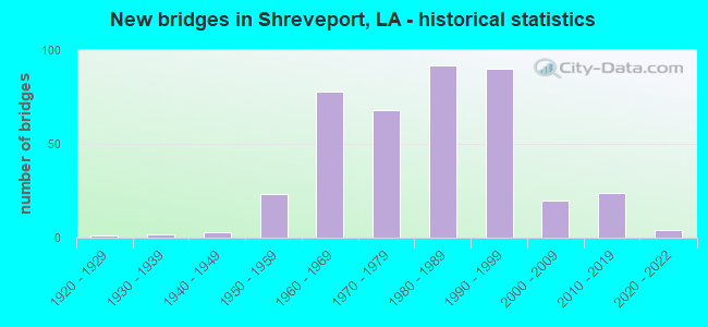
- New bridges - historical statistics
- 11920-1929
- 21930-1939
- 31940-1949
- 231950-1959
- 781960-1969
- 681970-1979
- 921980-1989
- 901990-1999
- 202000-2009
- 242010-2019
- 42020-2022
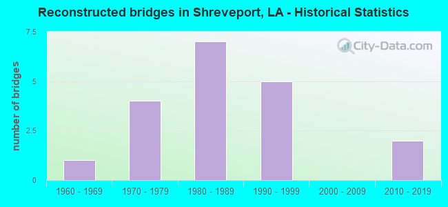
- Reconstructed bridges - Historical Statistics
- 11960-1969
- 41970-1979
- 71980-1989
- 51990-1999
- 02000-2009
- 22010-2019
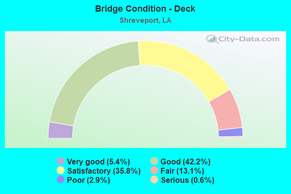
- Bridge Condition - Deck
- 5.4%Very good
- 42.2%Good
- 35.8%Satisfactory
- 13.1%Fair
- 2.9%Poor
- 0.6%Serious
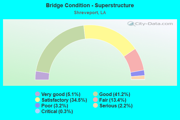
- Bridge Condition - Superstructure
- 5.1%Very good
- 41.2%Good
- 34.5%Satisfactory
- 13.4%Fair
- 3.2%Poor
- 2.2%Serious
- 0.3%Critical
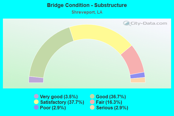
- Bridge Condition - Substructure
- 3.5%Very good
- 36.7%Good
- 37.7%Satisfactory
- 16.3%Fair
- 2.9%Poor
- 2.9%Serious
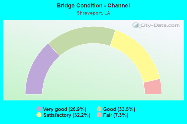
- Bridge Condition - Channel
- 26.9%Very good
- 33.5%Good
- 32.2%Satisfactory
- 7.3%Fair
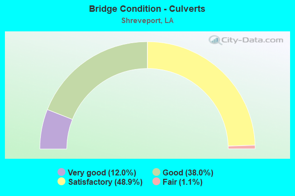
- Bridge Condition - Culverts
- 12.0%Very good
- 38.0%Good
- 48.9%Satisfactory
- 1.1%Fair
Find on map >> Show street view
Structure Number: 40904513005622, Location: 5.4 MI NORTH OF I-20 (Lat: 32.528700, Lng: -93.802500), Route carried "on" structure: Interstate 220, Year Built: 1979, Year Reconstructed: 2019, Status: Open, Structure Length: 9.75m (31.99ft), Average Daily Traffic: 35,800 (year 2016), Truck Traffic: 19%, Average Future Daily Traffic: 48,285 (year 2036), Design Load: HS 20, Features Intersected: RUSSELL ROAD
Minimum Vertical Clearance: 30+ m (98+ ft), Kilometerpoint: 4.184, Lanes on structure: 3, Lanes under structure: 2, Base Highway Network: Yes (Inventory Route: 451-30-2, Subroute: 10), Owner: State Highway Agency, Approaching Roadway Width: 16.2m (53.1ft), Skew: 10 degrees, Material/Design: Steel continuous, Design/Construction: Girder and Floorbeam System, Number Of Spans In Main Unit: 3, Length of Maximum Span: 43.3m (142.1ft), Curb-To-Curb Width: 16.3m (53.5ft), Out-to-Out Width: 17.1m (56.1ft)
Condition: Deck: Good, Superstructure: Satisfactory, Substructure: Satisfactory, Operating Rating: 39.5 metric tons, Method Used To Determine Operating Rating: Load and Resistance Factor Rating (LRFR) rating reported by rating factor(RF) method using HL-93 loadings, Inventory Rating: 30.5 metric tons, Method Used To Determine Inventory Rating: Load and Resistance Factor Rating (LRFR) rating reported by rating factor(RF) method using HL-93 loadings, Structural Evaluation: Equal to present minimum criteria, Deck Geometry: Equal to present minimum criteria, Underclear: Equal to present minimum criteria, Approach Roadway Alignment: Equal to present desirable criteria, Designated Inspection Frequency: Every 24 months, Inspection Date: Febuary 2021, Deck Structure Type: Concrete Cast-file-Place
Find on map >> Show street view
Structure Number: 40904513007791, Location: I-220 OVER US 71 (Lat: 32.553731, Lng: -93.781700), Route carried "on" structure: Interstate 220, Year Built: 1979, Status: Open, Structure Length: 9.30m (30.51ft), Average Daily Traffic: 35,800 (year 2016), Truck Traffic: 19%, Average Future Daily Traffic: 48,285 (year 2036), Design Load: HS 20, Features Intersected: US 71
Minimum Vertical Clearance: 30+ m (98+ ft), Kilometerpoint: 12.505, Lanes on structure: 3, Lanes under structure: 4, Base Highway Network: Yes (Inventory Route: 451-30-1, Subroute: 10), Owner: State Highway Agency, Approaching Roadway Width: 11.6m (38.1ft), Skew: 10 degrees, Material/Design: Steel continuous, Design/Construction: Girder and Floorbeam System, Number Of Spans In Main Unit: 3, Length of Maximum Span: 42.1m (138.1ft), Curb-To-Curb Width: 15.8m (51.8ft), Out-to-Out Width: 16.7m (54.8ft)
Condition: Deck: Satisfactory, Superstructure: Fair, Substructure: Fair, Operating Rating: 26.9 metric tons, Method Used To Determine Operating Rating: Load and Resistance Factor Rating (LRFR) rating reported by rating factor(RF) method using HL-93 loadings, Inventory Rating: 20.7 metric tons, Method Used To Determine Inventory Rating: Load and Resistance Factor Rating (LRFR) rating reported by rating factor(RF) method using HL-93 loadings, Structural Evaluation: Somewhat better than minimum adequacy, Deck Geometry: Somewhat better than minimum adequacy, Underclear: Equal to present minimum criteria, Approach Roadway Alignment: Equal to present desirable criteria, Length Of Structure Improvement: 10.21m (33.50ft), Designated Inspection Frequency: Every 24 months, Inspection Date: Febuary 2022, Bridge Improvement Cost: $1,130,000, Total Project Cost: $1,695,000 ( Estimate for 2016), Deck Structure Type: Concrete Cast-file-Place
Find on map >> Show street view
Structure Number: 40904513007792, Location: I-220 OVER US 71 (Lat: 32.554619, Lng: -93.781200), Route carried "on" structure: Interstate 220, Year Built: 1979, Status: Open, Structure Length: 9.30m (30.51ft), Average Daily Traffic: 35,800 (year 2016), Truck Traffic: 19%, Average Future Daily Traffic: 48,285 (year 2036), Design Load: HS 20, Features Intersected: US 71
Minimum Vertical Clearance: 30+ m (98+ ft), Kilometerpoint: 0.703, Lanes on structure: 3, Lanes under structure: 4, Base Highway Network: Yes (Inventory Route: 451-30-2, Subroute: 10), Owner: State Highway Agency, Approaching Roadway Width: 11.6m (38.1ft), Skew: 10 degrees, Material/Design: Steel continuous, Design/Construction: Girder and Floorbeam System, Number Of Spans In Main Unit: 3, Length of Maximum Span: 42.1m (138.1ft), Curb-To-Curb Width: 15.8m (51.8ft), Out-to-Out Width: 16.7m (54.8ft)
Condition: Deck: Satisfactory, Superstructure: Fair, Substructure: Fair, Operating Rating: 24.6 metric tons, Method Used To Determine Operating Rating: Load and Resistance Factor Rating (LRFR) rating reported by rating factor(RF) method using HL-93 loadings, Inventory Rating: 19.1 metric tons, Method Used To Determine Inventory Rating: Load and Resistance Factor Rating (LRFR) rating reported by rating factor(RF) method using HL-93 loadings, Structural Evaluation: Meets minimum limits, Deck Geometry: Somewhat better than minimum adequacy, Underclear: Superior to present desirable criteria, Approach Roadway Alignment: Equal to present desirable criteria, Length Of Structure Improvement: 10.21m (33.50ft), Designated Inspection Frequency: Every 24 months, Inspection Date: Febuary 2022, Bridge Improvement Cost: $1,130,000, Total Project Cost: $1,695,000 ( Estimate for 2016), Deck Structure Type: Concrete Cast-file-Place
Find on map >> Show street view
Structure Number: 40904550800001, Location: 4.0 MI S OF LA 526 INTG (Lat: 32.339139, Lng: -93.751589), Route carried "on" structure: Interstate 49, Year Built: 1989, Status: Open, Structure Length: 16.79m (55.09ft), Average Daily Traffic: 21,000 (year 2016), Truck Traffic: 36%, Average Future Daily Traffic: 29,736 (year 2036), Design Load: HS 20, Features Intersected: CYRPESS BAYOU
Minimum Vertical Clearance: 30+ m (98+ ft), Kilometerpoint: 0.000, Lanes on structure: 2, Base Highway Network: Yes (Inventory Route: 455-08-1, Subroute: 10), Owner: State Highway Agency, Approaching Roadway Width: 12.2m (40.0ft), Skew: 10 degrees, Material/Design: Prestressed concrete, Design/Construction: Stringer/Multi-beam, Number Of Spans In Main Unit: 11, Length of Maximum Span: 15.2m (49.9ft), Curb-To-Curb Width: 12.2m (40.0ft), Out-to-Out Width: 13.0m (42.7ft)
Condition: Deck: Good, Superstructure: Good, Substructure: Good, Channel: Good, Operating Rating: 66.2 metric tons, Method Used To Determine Operating Rating: Load Factor (LF), Inventory Rating: 32.7 metric tons, Method Used To Determine Inventory Rating: Load Factor (LF), Structural Evaluation: Better than present minimum criteria, Deck Geometry: Better than present minimum criteria, Waterway Adequacy: Equal to present desirable criteria, Approach Roadway Alignment: Equal to present desirable criteria, Designated Inspection Frequency: Every 24 months, Underwater Inspection Frequency: Every 60 months, Inspection Date: January 2021, Underwater Inspection Date: June 2020, Deck Structure Type: Concrete Cast-file-Place
Find on map >> Show street view
Structure Number: 40904550800002, Location: 4.0 MI S OF LA 526 INTR (Lat: 32.340681, Lng: -93.751961), Route carried "on" structure: Interstate 49, Year Built: 1989, Status: Open, Structure Length: 16.79m (55.09ft), Average Daily Traffic: 21,000 (year 2016), Truck Traffic: 36%, Average Future Daily Traffic: 29,736 (year 2036), Design Load: HS 20, Features Intersected: CYPRESS BAYOU
Minimum Vertical Clearance: 30+ m (98+ ft), Kilometerpoint: 17.976, Lanes on structure: 2, Base Highway Network: Yes (Inventory Route: 455-08-2, Subroute: 10), Owner: State Highway Agency, Approaching Roadway Width: 12.2m (40.0ft), Skew: 10 degrees, Material/Design: Prestressed concrete, Design/Construction: Stringer/Multi-beam, Number Of Spans In Main Unit: 11, Length of Maximum Span: 15.2m (49.9ft), Curb-To-Curb Width: 12.2m (40.0ft), Out-to-Out Width: 13.0m (42.7ft)
Condition: Deck: Good, Superstructure: Good, Substructure: Satisfactory, Channel: Good, Operating Rating: 66.2 metric tons, Method Used To Determine Operating Rating: Load Factor (LF), Inventory Rating: 32.7 metric tons, Method Used To Determine Inventory Rating: Load Factor (LF), Structural Evaluation: Equal to present minimum criteria, Deck Geometry: Better than present minimum criteria, Waterway Adequacy: Equal to present desirable criteria, Approach Roadway Alignment: Equal to present desirable criteria, Designated Inspection Frequency: Every 24 months, Underwater Inspection Frequency: Every 60 months, Inspection Date: January 2021, Underwater Inspection Date: June 2020, Deck Structure Type: Concrete Cast-file-Place
Find on map >> Show street view
Structure Number: 40904550800441, Location: 3.6 M S OF LA 526 INTR (Lat: 32.345489, Lng: -93.751600), Route carried "on" structure: Interstate 49, Year Built: 1989, Status: Open, Structure Length: 4.60m (15.09ft), Average Daily Traffic: 21,000 (year 2016), Truck Traffic: 36%, Average Future Daily Traffic: 29,736 (year 2036), Design Load: HS 20, Features Intersected: CYPRESS SLOUGH
Minimum Vertical Clearance: 30+ m (98+ ft), Kilometerpoint: 0.703, Lanes on structure: 2, Base Highway Network: Yes (Inventory Route: 455-08-1, Subroute: 10), Owner: State Highway Agency, Approaching Roadway Width: 12.2m (40.0ft), Skew: 10 degrees, Material/Design: Prestressed concrete, Design/Construction: Stringer/Multi-beam, Number Of Spans In Main Unit: 3, Length of Maximum Span: 15.2m (49.9ft), Curb-To-Curb Width: 12.2m (40.0ft), Out-to-Out Width: 13.0m (42.7ft)
Condition: Deck: Good, Superstructure: Satisfactory, Substructure: Good, Channel: Very good, Operating Rating: 66.2 metric tons, Method Used To Determine Operating Rating: Load Factor (LF), Inventory Rating: 32.7 metric tons, Method Used To Determine Inventory Rating: Load Factor (LF), Structural Evaluation: Equal to present minimum criteria, Deck Geometry: Better than present minimum criteria, Waterway Adequacy: Equal to present desirable criteria, Approach Roadway Alignment: Equal to present desirable criteria, Designated Inspection Frequency: Every 24 months, Underwater Inspection Frequency: Every 60 months, Inspection Date: January 2021, Underwater Inspection Date: November 2020, Deck Structure Type: Concrete Cast-file-Place
Find on map >> Show street view
Structure Number: 40904550800442, Location: 3.6 M S OF LA 526 INTR (Lat: 32.345981, Lng: -93.751900), Route carried "on" structure: Interstate 49, Year Built: 1989, Status: Open, Structure Length: 4.60m (15.09ft), Average Daily Traffic: 21,000 (year 2016), Truck Traffic: 36%, Average Future Daily Traffic: 29,736 (year 2036), Design Load: HS 20, Features Intersected: CYPRESS SLOUGH
Minimum Vertical Clearance: 30+ m (98+ ft), Kilometerpoint: 17.389, Lanes on structure: 2, Base Highway Network: Yes (Inventory Route: 455-08-2, Subroute: 10), Owner: State Highway Agency, Approaching Roadway Width: 12.2m (40.0ft), Skew: 10 degrees, Material/Design: Prestressed concrete, Design/Construction: Stringer/Multi-beam, Number Of Spans In Main Unit: 3, Length of Maximum Span: 15.2m (49.9ft), Curb-To-Curb Width: 12.2m (40.0ft), Out-to-Out Width: 13.0m (42.7ft)
Condition: Deck: Good, Superstructure: Good, Substructure: Satisfactory, Channel: Very good, Operating Rating: 64.4 metric tons, Method Used To Determine Operating Rating: Load Factor (LF), Inventory Rating: 34.5 metric tons, Method Used To Determine Inventory Rating: Load Factor (LF), Structural Evaluation: Equal to present minimum criteria, Deck Geometry: Better than present minimum criteria, Waterway Adequacy: Equal to present desirable criteria, Approach Roadway Alignment: Equal to present desirable criteria, Designated Inspection Frequency: Every 24 months, Underwater Inspection Frequency: Every 60 months, Inspection Date: January 2021, Underwater Inspection Date: November 2020, Deck Structure Type: Concrete Cast-file-Place
Find on map >> Show street view
Structure Number: 40904550801181, Location: 2.97 MI SOUTH OF LA 526 (Lat: 32.356300, Lng: -93.752450), Route carried "on" structure: County highway , Year Built: 2005, Status: Open, Structure Length: 12.01m (39.40ft), Average Daily Traffic: 42,000 (year 2015), Average Future Daily Traffic: 49,560 (year 2036), Design Load: HS 20, Features Intersected: I-49, Facility Carried by Structure: SOUTHERN LOOP
Minimum Vertical Clearance: 30+ m (98+ ft), Kilometerpoint: 1.886, Lanes on structure: 2, Lanes under structure: 4, Owner: State Highway Agency, Approaching Roadway Width: 14.6m (47.9ft), Skew: 10 degrees, Material/Design: Prestressed concrete continuous, Design/Construction: Stringer/Multi-beam, Number Of Spans In Main Unit: 4, Length of Maximum Span: 32.9m (107.9ft), Curb-To-Curb Width: 14.7m (48.2ft), Out-to-Out Width: 20.3m (66.6ft)
Condition: Deck: Good, Superstructure: Good, Substructure: Good, Operating Rating: 72.6 metric tons, Method Used To Determine Operating Rating: Load Factor (LF), Inventory Rating: 41.7 metric tons, Method Used To Determine Inventory Rating: Load Factor (LF), Structural Evaluation: Better than present minimum criteria, Deck Geometry: Superior to present desirable criteria, Approach Roadway Alignment: Equal to present desirable criteria, Designated Inspection Frequency: Every 24 months, Inspection Date: January 2021, Deck Structure Type: Concrete Cast-file-Place
Find on map >> Show street view
Structure Number: 40904550802281, Location: 1.8 M S OF LA 526 INTR (Lat: 32.372261, Lng: -93.751700), Route carried "on" structure: Interstate 49, Year Built: 1989, Status: Open, Structure Length: 0.67m (2.20ft), Average Daily Traffic: 42,000 (year 2016), Truck Traffic: 19%, Average Future Daily Traffic: 49,560 (year 2036), Design Load: HS 20, Features Intersected: DRAIN
Minimum Vertical Clearance: 30+ m (98+ ft), Kilometerpoint: 3.671, Lanes on structure: 4, Base Highway Network: Yes (Inventory Route: 455-08-1, Subroute: 10), Owner: State Highway Agency, Approaching Roadway Width: 23.2m (76.1ft), Skew: 13 degrees, Material/Design: Concrete, Design/Construction: Culvert, Number Of Spans In Main Unit: 3, Length of Maximum Span: 1.8m (5.9ft), Curb-To-Curb Width: 23.2m (76.1ft), Out-to-Out Width: 74.4m (244.1ft)
Condition: Channel: Good, Culverts: Satisfactory, Operating Rating: 42.1 metric tons, Method Used To Determine Operating Rating: Load and Resistance Factor Rating (LRFR) rating reported by rating factor(RF) method using HL-93 loadings, Inventory Rating: 32.4 metric tons, Method Used To Determine Inventory Rating: Load and Resistance Factor Rating (LRFR) rating reported by rating factor(RF) method using HL-93 loadings, Structural Evaluation: Equal to present minimum criteria, Deck Geometry: Superior to present desirable criteria, Waterway Adequacy: Equal to present desirable criteria, Approach Roadway Alignment: Equal to present desirable criteria, Designated Inspection Frequency: Every 24 months, Inspection Date: January 2021, Deck Structure Type: Concrete Cast-file-Place
Find on map >> Show street view
Structure Number: 40904550802581, Location: 1.5 M SO OF LA 526 INTR (Lat: 32.376581, Lng: -93.751400), Route carried "on" structure: County highway , Year Built: 1989, Status: Open, Structure Length: 8.87m (29.10ft), Average Daily Traffic: 4,200 (year 2015), Average Future Daily Traffic: 4,956 (year 2036), Design Load: HS 20, Features Intersected: I-49 UNDER MAYO ROAD, Facility Carried by Structure: MAYO RD
Minimum Vertical Clearance: 30+ m (98+ ft), Kilometerpoint: 4.142, Lanes on structure: 2, Lanes under structure: 4, Base Highway Network: Yes (Inventory Route: 455-08-1, Subroute: 10), Owner: State Highway Agency, Approaching Roadway Width: 13.4m (44.0ft), Material/Design: Steel continuous, Design/Construction: Girder and Floorbeam System, Number Of Spans In Main Unit: 2, Length of Maximum Span: 74.4m (244.1ft), Curb-To-Curb Width: 13.4m (44.0ft), Out-to-Out Width: 14.3m (46.9ft)
Condition: Deck: Satisfactory, Superstructure: Satisfactory, Substructure: Good, Operating Rating: 62.6 metric tons, Method Used To Determine Operating Rating: Load Factor (LF), Inventory Rating: 37.2 metric tons, Method Used To Determine Inventory Rating: Load Factor (LF), Structural Evaluation: Equal to present minimum criteria, Deck Geometry: Better than present minimum criteria, Underclear: Superior to present desirable criteria, Approach Roadway Alignment: Equal to present desirable criteria, Designated Inspection Frequency: Every 24 months, Inspection Date: Febuary 2022, Deck Structure Type: Concrete Cast-file-Place
Find on map >> Show street view
Structure Number: 40904550803571, Location: 0.5 M S OF LA 526 INTR (Lat: 32.390931, Lng: -93.751400), Route carried "on" structure: County highway , Year Built: 1989, Status: Open, Structure Length: 9.60m (31.50ft), Average Daily Traffic: 4,200 (year 2015), Average Future Daily Traffic: 4,956 (year 2036), Design Load: HS 20, Features Intersected: I-49 UNDR FLOURNOY-LUCAS, Facility Carried by Structure: FLOURNOY LUCAS RD
Minimum Vertical Clearance: 30+ m (98+ ft), Kilometerpoint: 5.734, Lanes on structure: 2, Lanes under structure: 4, Base Highway Network: Yes (Inventory Route: 455-08-1, Subroute: 10), Owner: State Highway Agency, Approaching Roadway Width: 13.4m (44.0ft), Material/Design: Steel continuous, Design/Construction: Girder and Floorbeam System, Number Of Spans In Main Unit: 2, Length of Maximum Span: 49.4m (162.1ft), Curb-To-Curb Width: 13.4m (44.0ft), Out-to-Out Width: 14.3m (46.9ft)
Condition: Deck: Good, Superstructure: Good, Substructure: Good, Operating Rating: 61.7 metric tons, Method Used To Determine Operating Rating: Load Factor (LF), Inventory Rating: 36.3 metric tons, Method Used To Determine Inventory Rating: Load Factor (LF), Structural Evaluation: Better than present minimum criteria, Deck Geometry: Better than present minimum criteria, Underclear: Superior to present desirable criteria, Approach Roadway Alignment: Equal to present desirable criteria, Designated Inspection Frequency: Every 24 months, Inspection Date: January 2021, Deck Structure Type: Concrete Cast-file-Place
Find on map >> Show street view
Structure Number: 40904550804051, Location: 1.35M SOUTH OF LA3132 INT (Lat: 32.397861, Lng: -93.751700), Route carried "on" structure: Interstate 49, Year Built: 1991, Status: Open, Structure Length: 10.09m (33.10ft), Average Daily Traffic: 21,000 (year 2016), Truck Traffic: 19%, Average Future Daily Traffic: 29,736 (year 2036), Design Load: HS 20, Features Intersected: LA 526 INT
Minimum Vertical Clearance: 30+ m (98+ ft), Kilometerpoint: 6.508, Lanes on structure: 2, Lanes under structure: 6, Base Highway Network: Yes (Inventory Route: 455-08-1, Subroute: 10), Owner: State Highway Agency, Approaching Roadway Width: 11.6m (38.1ft), Skew: 10 degrees, Material/Design: Steel continuous, Design/Construction: Box Beam or Girders - Multiple, Number Of Spans In Main Unit: 3, Length of Maximum Span: 44.8m (147.0ft), Curb-To-Curb Width: 12.2m (40.0ft), Out-to-Out Width: 13.0m (42.7ft)
Condition: Deck: Satisfactory, Superstructure: Good, Substructure: Good, Operating Rating: 44.4 metric tons, Method Used To Determine Operating Rating: Load Factor (LF), Inventory Rating: 32.7 metric tons, Method Used To Determine Inventory Rating: Load Factor (LF), Structural Evaluation: Better than present minimum criteria, Deck Geometry: Better than present minimum criteria, Approach Roadway Alignment: Equal to present desirable criteria, Designated Inspection Frequency: Every 24 months, Critical Feature Inspection Frequency: Every 24 months, Inspection Date: January 2021, Critical Feature Inspection Date: January 2021, Deck Structure Type: Concrete Cast-file-Place
Find on map >> Show street view
Structure Number: 40904550804052, Location: 1.35M SOUTH OF LA3132 INT (Lat: 32.398900, Lng: -93.752100), Route carried "on" structure: Interstate 49, Year Built: 1991, Status: Open, Structure Length: 10.09m (33.10ft), Average Daily Traffic: 21,000 (year 2016), Truck Traffic: 19%, Average Future Daily Traffic: 29,736 (year 2036), Design Load: HS 20, Features Intersected: LA 526 INT
Minimum Vertical Clearance: 30+ m (98+ ft), Kilometerpoint: 11.523, Lanes on structure: 2, Lanes under structure: 6, Base Highway Network: Yes (Inventory Route: 455-08-2, Subroute: 10), Owner: State Highway Agency, Approaching Roadway Width: 11.6m (38.1ft), Skew: 10 degrees, Material/Design: Steel continuous, Design/Construction: Box Beam or Girders - Multiple, Number Of Spans In Main Unit: 3, Length of Maximum Span: 44.8m (147.0ft), Curb-To-Curb Width: 12.2m (40.0ft), Out-to-Out Width: 13.0m (42.7ft)
Condition: Deck: Satisfactory, Superstructure: Good, Substructure: Good, Operating Rating: 27.2 metric tons, Method Used To Determine Operating Rating: Load and Resistance Factor Rating (LRFR) rating reported by rating factor(RF) method using HL-93 loadings, Inventory Rating: 21.1 metric tons, Method Used To Determine Inventory Rating: Load and Resistance Factor Rating (LRFR) rating reported by rating factor(RF) method using HL-93 loadings, Structural Evaluation: Somewhat better than minimum adequacy, Deck Geometry: Better than present minimum criteria, Underclear: High priority of corrective action, Approach Roadway Alignment: Better than present minimum criteria, Designated Inspection Frequency: Every 24 months, Critical Feature Inspection Frequency: Every 24 months, Inspection Date: January 2021, Critical Feature Inspection Date: January 2021, Deck Structure Type: Concrete Cast-file-Place
Find on map >> Show street view
Structure Number: 40904550805237, Location: RAMP SE AT LA 3132 INTG (Lat: 32.414731, Lng: -93.750800), Route carried "on" structure: Ramp Interstate 49, Year Built: 1991, Status: Open, Structure Length: 69.01m (226.41ft), Average Daily Traffic: 4,180 (year 2016), Truck Traffic: 19%, Average Future Daily Traffic: 4,932 (year 2036), Design Load: HS 20, Features Intersected: ST VINCENT & KCS R/R
Minimum Vertical Clearance: 30+ m (98+ ft), Kilometerpoint: 0.557, Lanes on structure: 1, Lanes under structure: 9, Owner: State Highway Agency, Approaching Roadway Width: 8.2m (26.9ft), Material/Design: Concrete continuous, Design/Construction: Box Beam or Girders - Multiple, Number Of Spans In Main Unit: 20, Length of Maximum Span: 37.8m (124.0ft), Curb-To-Curb Width: 8.1m (26.6ft), Out-to-Out Width: 8.9m (29.2ft)
Condition: Deck: Good, Superstructure: Good, Substructure: Good, Operating Rating: 59.0 metric tons, Method Used To Determine Operating Rating: Load Factor (LF), Inventory Rating: 35.4 metric tons, Method Used To Determine Inventory Rating: Load Factor (LF), Structural Evaluation: Better than present minimum criteria, Deck Geometry: Superior to present desirable criteria, Underclear: Somewhat better than minimum adequacy, Approach Roadway Alignment: Equal to present desirable criteria, Designated Inspection Frequency: Every 24 months, Inspection Date: June 2020, Deck Structure Type: Concrete Cast-file-Place
Find on map >> Show street view
Structure Number: 40904550805276, Location: RAMP WS AT LA 3132 INTG (Lat: 32.418150, Lng: -93.752100), Route carried "on" structure: Ramp Interstate 49, Year Built: 1991, Status: Open, Structure Length: 27.74m (91.01ft), Average Daily Traffic: 4,180 (year 2016), Truck Traffic: 19%, Average Future Daily Traffic: 4,932 (year 2036), Design Load: HS 20, Features Intersected: MT ZION RD
Minimum Vertical Clearance: 30+ m (98+ ft), Kilometerpoint: 0.517, Lanes on structure: 1, Lanes under structure: 2, Owner: State Highway Agency, Approaching Roadway Width: 9.4m (30.8ft), Material/Design: Concrete continuous, Design/Construction: Box Beam or Girders - Multiple, Number Of Spans In Main Unit: 8, Length of Maximum Span: 37.5m (123.0ft), Curb-To-Curb Width: 9.5m (31.2ft), Out-to-Out Width: 10.3m (33.8ft)
Condition: Deck: Good, Superstructure: Good, Substructure: Good, Operating Rating: 80.7 metric tons, Method Used To Determine Operating Rating: Load Factor (LF), Inventory Rating: 49.0 metric tons, Method Used To Determine Inventory Rating: Load Factor (LF), Structural Evaluation: Better than present minimum criteria, Deck Geometry: Superior to present desirable criteria, Underclear: Superior to present desirable criteria, Approach Roadway Alignment: Better than present minimum criteria, Designated Inspection Frequency: Every 24 months, Inspection Date: August 2021, Deck Structure Type: Concrete Cast-file-Place
Find on map >> Show street view
Structure Number: 40904550805287, Location: RAMP SW AT LA 3132 INTG (Lat: 32.415450, Lng: -93.750561), Route carried "on" structure: Ramp Interstate 49, Year Built: 1991, Status: Open, Structure Length: 68.82m (225.79ft), Average Daily Traffic: 4,180 (year 2016), Truck Traffic: 19%, Average Future Daily Traffic: 4,932 (year 2036), Design Load: HS 20, Features Intersected: RAMPS ES & WN
Minimum Vertical Clearance: 30+ m (98+ ft), Kilometerpoint: 0.143, Lanes on structure: 1, Lanes under structure: 6, Owner: State Highway Agency, Approaching Roadway Width: 9.1m (29.9ft), Material/Design: Steel continuous, Design/Construction: Box Beam or Girders - Multiple, Number Of Spans In Main Unit: 4, Number Of Approach Spans: 13, Length of Maximum Span: 59.4m (194.9ft), Curb-To-Curb Width: 10.1m (33.1ft), Out-to-Out Width: 10.9m (35.8ft)
Condition: Deck: Good, Superstructure: Good, Substructure: Good, Operating Rating: 56.2 metric tons, Method Used To Determine Operating Rating: Load Factor (LF), Inventory Rating: 33.6 metric tons, Method Used To Determine Inventory Rating: Load Factor (LF), Structural Evaluation: Better than present minimum criteria, Deck Geometry: Superior to present desirable criteria, Underclear: Somewhat better than minimum adequacy, Approach Roadway Alignment: Better than present minimum criteria, Designated Inspection Frequency: Every 24 months, Critical Feature Inspection Frequency: Every 24 months, Inspection Date: June 2020, Critical Feature Inspection Date: June 2020, Deck Structure Type: Concrete Cast-file-Place
Find on map >> Show street view
Structure Number: 40904550805326, Location: RAMP ES AT LA 3132 INTG (Lat: 32.419281, Lng: -93.746300), Route carried "on" structure: Ramp Interstate 49, Year Built: 1991, Status: Open, Structure Length: 68.95m (226.21ft), Average Daily Traffic: 4,180 (year 2016), Truck Traffic: 19%, Average Future Daily Traffic: 4,932 (year 2036), Design Load: HS 20, Features Intersected: I-49 & KCS R/R
Minimum Vertical Clearance: 5.49m (18.01ft), Kilometerpoint: 0.093, Lanes on structure: 1, Lanes under structure: 12, Owner: State Highway Agency, Approaching Roadway Width: 12.8m (42.0ft), Material/Design: Steel continuous, Design/Construction: Box Beam or Girders - Multiple, Number Of Spans In Main Unit: 4, Number Of Approach Spans: 13, Length of Maximum Span: 59.4m (194.9ft), Curb-To-Curb Width: 9.8m (32.2ft), Out-to-Out Width: 10.6m (34.8ft)
Condition: Deck: Good, Superstructure: Good, Substructure: Good, Operating Rating: 63.5 metric tons, Method Used To Determine Operating Rating: Load Factor (LF), Inventory Rating: 32.7 metric tons, Method Used To Determine Inventory Rating: Load Factor (LF), Structural Evaluation: Better than present minimum criteria, Deck Geometry: Superior to present desirable criteria, Underclear: Meets minimum limits, Approach Roadway Alignment: Equal to present minimum criteria, Designated Inspection Frequency: Every 24 months, Critical Feature Inspection Frequency: Every 24 months, Inspection Date: June 2020, Critical Feature Inspection Date: June 2020, Deck Structure Type: Concrete Cast-file-Place
Find on map >> Show street view
Structure Number: 40904550805401, Location: 1.35M NORTH OF LA 526 (Lat: 32.417100, Lng: -93.750300), Route carried "on" structure: Interstate 49, Year Built: 1991, Status: Open, Structure Length: 74.22m (243.50ft), Average Daily Traffic: 29,250 (year 2016), Truck Traffic: 19%, Average Future Daily Traffic: 29,594 (year 2036), Design Load: HS 20, Features Intersected: LA 3132/RAMPS/T&P RR
Minimum Vertical Clearance: 5.41m (17.75ft), Kilometerpoint: 8.658, Lanes on structure: 3, Lanes under structure: 10, Base Highway Network: Yes (Inventory Route: 455-08-1, Subroute: 10), Owner: State Highway Agency, Approaching Roadway Width: 18.3m (60.0ft), Skew: 11 degrees, Material/Design: Prestressed concrete, Design/Construction: Stringer/Multi-beam, Number Of Spans In Main Unit: 27, Length of Maximum Span: 38.1m (125.0ft), Curb-To-Curb Width: 18.4m (60.4ft), Out-to-Out Width: 19.1m (62.7ft)
Condition: Deck: Good, Superstructure: Good, Substructure: Good, Operating Rating: 66.2 metric tons, Method Used To Determine Operating Rating: Load Factor (LF), Inventory Rating: 32.7 metric tons, Method Used To Determine Inventory Rating: Load Factor (LF), Structural Evaluation: Better than present minimum criteria, Deck Geometry: Equal to present desirable criteria, Underclear: Equal to present minimum criteria, Approach Roadway Alignment: Equal to present desirable criteria, Designated Inspection Frequency: Every 24 months, Inspection Date: Febuary 2022, Deck Structure Type: Concrete Cast-file-Place
Find on map >> Show street view
Structure Number: 40904550805402, Location: 1.35M NORTH OF LA 526 (Lat: 32.423661, Lng: -93.749900), Route carried "on" structure: Interstate 49, Year Built: 1991, Status: Open, Structure Length: 71.93m (235.99ft), Average Daily Traffic: 29,250 (year 2016), Truck Traffic: 19%, Average Future Daily Traffic: 42,126 (year 2036), Design Load: HS 20, Features Intersected: LA 3132/RAMPS/T&P RR
Minimum Vertical Clearance: 5.44m (17.85ft), Kilometerpoint: 8.739, Lanes on structure: 3, Lanes under structure: 10, Base Highway Network: Yes (Inventory Route: 455-08-2, Subroute: 10), Owner: State Highway Agency, Approaching Roadway Width: 18.3m (60.0ft), Skew: 11 degrees, Material/Design: Prestressed concrete, Design/Construction: Stringer/Multi-beam, Number Of Spans In Main Unit: 27, Length of Maximum Span: 38.1m (125.0ft), Curb-To-Curb Width: 18.3m (60.0ft), Out-to-Out Width: 19.1m (62.7ft)
Condition: Deck: Good, Superstructure: Good, Substructure: Good, Operating Rating: 62.6 metric tons, Method Used To Determine Operating Rating: Load Factor (LF), Inventory Rating: 32.7 metric tons, Method Used To Determine Inventory Rating: Load Factor (LF), Structural Evaluation: Better than present minimum criteria, Deck Geometry: Better than present minimum criteria, Underclear: Equal to present minimum criteria, Approach Roadway Alignment: Equal to present desirable criteria, Designated Inspection Frequency: Every 24 months, Inspection Date: Febuary 2022, Deck Structure Type: Concrete Cast-file-Place
Find on map >> Show street view
Structure Number: 40904550805705, Location: 1.65M NORTH OF LA 526 INT (Lat: 32.418781, Lng: -93.752700), Route carried "on" structure: Ramp Interstate 49, Year Built: 1991, Status: Open, Structure Length: 62.15m (203.90ft), Average Daily Traffic: 4,180 (year 2016), Truck Traffic: 19%, Average Future Daily Traffic: 4,932 (year 2036), Design Load: HS 20, Features Intersected: I-49/RAMPS/KCS RR
Minimum Vertical Clearance: 5.61m (18.41ft), Kilometerpoint: 0.121, Lanes on structure: 1, Lanes under structure: 11, Owner: State Highway Agency, Approaching Roadway Width: 9.8m (32.2ft), Material/Design: Steel continuous, Design/Construction: Box Beam or Girders - Multiple, Number Of Spans In Main Unit: 7, Number Of Approach Spans: 7, Length of Maximum Span: 69.2m (227.0ft), Curb-To-Curb Width: 9.8m (32.2ft), Out-to-Out Width: 10.6m (34.8ft)
Condition: Deck: Good, Superstructure: Good, Substructure: Good, Operating Rating: 64.4 metric tons, Method Used To Determine Operating Rating: Load Factor (LF), Inventory Rating: 32.7 metric tons, Method Used To Determine Inventory Rating: Load Factor (LF), Structural Evaluation: Better than present minimum criteria, Deck Geometry: Superior to present desirable criteria, Underclear: Meets minimum limits, Approach Roadway Alignment: Better than present minimum criteria, Designated Inspection Frequency: Every 24 months, Critical Feature Inspection Frequency: Every 24 months, Inspection Date: June 2020, Critical Feature Inspection Date: June 2020, Deck Structure Type: Concrete Cast-file-Place
Find on map >> Show street view
Structure Number: 40904550805758, Location: 1.35M NORTH OF LA 526 (Lat: 32.422089, Lng: -93.749861), Route carried "on" structure: Ramp Interstate 49, Year Built: 1991, Status: Open, Structure Length: 63.70m (208.99ft), Average Daily Traffic: 4,180 (year 2016), Truck Traffic: 19%, Average Future Daily Traffic: 7,021 (year 2036), Design Load: HS 20, Features Intersected: RAMPS/T&P RR
Minimum Vertical Clearance: 30+ m (98+ ft), Kilometerpoint: 0.303, Lanes on structure: 2, Lanes under structure: 3, Owner: State Highway Agency, Approaching Roadway Width: 13.1m (43.0ft), Material/Design: Steel continuous, Design/Construction: Box Beam or Girders - Multiple, Number Of Spans In Main Unit: 4, Number Of Approach Spans: 13, Length of Maximum Span: 59.4m (194.9ft), Curb-To-Curb Width: 13.2m (43.3ft), Out-to-Out Width: 14.0m (45.9ft)
Condition: Deck: Good, Superstructure: Satisfactory, Substructure: Good, Operating Rating: 67.1 metric tons, Method Used To Determine Operating Rating: Load Factor (LF), Inventory Rating: 39.9 metric tons, Method Used To Determine Inventory Rating: Load Factor (LF), Structural Evaluation: Equal to present minimum criteria, Deck Geometry: Superior to present desirable criteria, Underclear: Somewhat better than minimum adequacy, Approach Roadway Alignment: Better than present minimum criteria, Designated Inspection Frequency: Every 24 months, Critical Feature Inspection Frequency: Every 24 months, Inspection Date: June 2020, Critical Feature Inspection Date: June 2020, Deck Structure Type: Concrete Cast-file-Place
Find on map >> Show street view
Structure Number: 40904550805858, Location: 1.40M NORTH OF LA 526 INT (Lat: 32.423469, Lng: -93.750100), Route carried "on" structure: Ramp Interstate 49, Year Built: 1991, Status: Open, Structure Length: 47.37m (155.41ft), Average Daily Traffic: 5,850 (year 2016), Truck Traffic: 19%, Average Future Daily Traffic: 7,021 (year 2036), Design Load: HS 20, Features Intersected: T & P R/R
Minimum Vertical Clearance: 30+ m (98+ ft), Kilometerpoint: 0.306, Lanes on structure: 1, Owner: State Highway Agency, Approaching Roadway Width: 9.4m (30.8ft), Material/Design: Concrete continuous, Design/Construction: Box Beam or Girders - Multiple, Number Of Spans In Main Unit: 15, Length of Maximum Span: 32.3m (106.0ft), Curb-To-Curb Width: 9.5m (31.2ft), Out-to-Out Width: 10.3m (33.8ft)
Condition: Deck: Good, Superstructure: Good, Substructure: Good, Operating Rating: 60.8 metric tons, Method Used To Determine Operating Rating: Load Factor (LF), Inventory Rating: 33.6 metric tons, Method Used To Determine Inventory Rating: Load Factor (LF), Structural Evaluation: Better than present minimum criteria, Deck Geometry: Superior to present desirable criteria, Underclear: Equal to present minimum criteria, Approach Roadway Alignment: Equal to present desirable criteria, Designated Inspection Frequency: Every 24 months, Inspection Date: August 2021, Deck Structure Type: Concrete Cast-file-Place
Find on map >> Show street view
Structure Number: 40904550805865, Location: 1.81M NORTH OF LA 526 INT (Lat: 32.419089, Lng: -93.745419), Route carried "on" structure: Ramp Interstate 49, Year Built: 1991, Status: Open, Structure Length: 67.73m (222.21ft), Average Daily Traffic: 4,180 (year 2016), Truck Traffic: 19%, Average Future Daily Traffic: 4,932 (year 2036), Design Load: HS 20, Features Intersected: KCS/T&P RR
Minimum Vertical Clearance: 30+ m (98+ ft), Kilometerpoint: 0.563, Lanes on structure: 2, Owner: State Highway Agency, Approaching Roadway Width: 13.1m (43.0ft), Material/Design: Steel continuous, Design/Construction: Box Beam or Girders - Multiple, Number Of Spans In Main Unit: 3, Number Of Approach Spans: 16, Length of Maximum Span: 55.5m (182.1ft), Curb-To-Curb Width: 13.2m (43.3ft), Out-to-Out Width: 14.0m (45.9ft)
Condition: Deck: Good, Superstructure: Satisfactory, Substructure: Good, Operating Rating: 67.1 metric tons, Method Used To Determine Operating Rating: Load Factor (LF), Inventory Rating: 36.3 metric tons, Method Used To Determine Inventory Rating: Load Factor (LF), Structural Evaluation: Equal to present minimum criteria, Deck Geometry: Superior to present desirable criteria, Underclear: Equal to present minimum criteria, Approach Roadway Alignment: Better than present minimum criteria, Designated Inspection Frequency: Every 24 months, Inspection Date: June 2020, Deck Structure Type: Concrete Cast-file-Place
Find on map >> Show street view
Structure Number: 40904550806111, Location: 1.9 MI NORTH OF LA 526 (Lat: 32.426989, Lng: -93.751600), Route carried "on" structure: Interstate 49, Year Built: 1991, Status: Open, Structure Length: 121.49m (398.59ft), Average Daily Traffic: 29,250 (year 2016), Truck Traffic: 19%, Average Future Daily Traffic: 42,126 (year 2036), Design Load: HS 20, Features Intersected: CITY STS/KCS RR
Minimum Vertical Clearance: 30+ m (98+ ft), Kilometerpoint: 9.830, Lanes on structure: 3, Lanes under structure: 8, Base Highway Network: Yes (Inventory Route: 455-08-1, Subroute: 10), Owner: State Highway Agency, Approaching Roadway Width: 25.6m (84.0ft), Skew: 10 degrees, Material/Design: Steel, Design/Construction: Girder and Floorbeam System, Number Of Spans In Main Unit: 4, Number Of Approach Spans: 41, Length of Maximum Span: 46.6m (152.9ft), Curb-To-Curb Width: 18.3m (60.0ft), Out-to-Out Width: 19.1m (62.7ft)
Condition: Deck: Good, Superstructure: Satisfactory, Substructure: Good, Operating Rating: 54.4 metric tons, Method Used To Determine Operating Rating: Load Factor (LF), Inventory Rating: 32.7 metric tons, Method Used To Determine Inventory Rating: Load Factor (LF), Structural Evaluation: Equal to present minimum criteria, Deck Geometry: Better than present minimum criteria, Underclear: Somewhat better than minimum adequacy, Approach Roadway Alignment: Equal to present desirable criteria, Designated Inspection Frequency: Every 24 months, Critical Feature Inspection Frequency: Every 24 months, Inspection Date: June 2020, Critical Feature Inspection Date: June 2020, Deck Structure Type: Concrete Cast-file-Place
Find on map >> Show street view
Structure Number: 40904550806112, Location: 0.5 MI NORTH OF LA 3132 (Lat: 32.437219, Lng: -93.756100), Route carried "on" structure: Interstate 49, Year Built: 1991, Status: Open, Structure Length: 121.49m (398.59ft), Average Daily Traffic: 29,250 (year 2016), Truck Traffic: 19%, Average Future Daily Traffic: 42,126 (year 2036), Design Load: HS 20, Features Intersected: CITY STS/KCS RR
Minimum Vertical Clearance: 30+ m (98+ ft), Kilometerpoint: 7.108, Lanes on structure: 3, Lanes under structure: 8, Base Highway Network: Yes (Inventory Route: 455-08-2, Subroute: 10), Owner: State Highway Agency, Approaching Roadway Width: 21.9m (71.9ft), Skew: 19 degrees, Material/Design: Steel, Design/Construction: Girder and Floorbeam System, Number Of Spans In Main Unit: 3, Number Of Approach Spans: 42, Length of Maximum Span: 38.7m (127.0ft), Curb-To-Curb Width: 18.3m (60.0ft), Out-to-Out Width: 19.1m (62.7ft)
Condition: Deck: Good, Superstructure: Satisfactory, Substructure: Good, Operating Rating: 54.4 metric tons, Method Used To Determine Operating Rating: Load Factor (LF), Inventory Rating: 32.7 metric tons, Method Used To Determine Inventory Rating: Load Factor (LF), Structural Evaluation: Equal to present minimum criteria, Deck Geometry: Better than present minimum criteria, Underclear: Somewhat better than minimum adequacy, Approach Roadway Alignment: Equal to present desirable criteria, Designated Inspection Frequency: Every 24 months, Critical Feature Inspection Frequency: Every 24 months, Inspection Date: June 2020, Critical Feature Inspection Date: June 2020, Deck Structure Type: Concrete Cast-file-Place
Find on map >> Show street view
Structure Number: 40904550807191, Location: I-49 OVER LA 511 (Lat: 32.441761, Lng: -93.756300), Route carried "on" structure: Interstate 49, Year Built: 1993, Status: Open, Structure Length: 3.84m (12.60ft), Average Daily Traffic: 29,250 (year 2016), Truck Traffic: 19%, Average Future Daily Traffic: 42,126 (year 2036), Design Load: HS 20, Features Intersected: LA 511
Minimum Vertical Clearance: 30+ m (98+ ft), Kilometerpoint: 11.542, Lanes on structure: 3, Lanes under structure: 7, Base Highway Network: Yes (Inventory Route: 455-08-1, Subroute: 10), Owner: State Highway Agency, Approaching Roadway Width: 18.3m (60.0ft), Skew: 10 degrees, Material/Design: Prestressed concrete, Design/Construction: Stringer/Multi-beam, Number Of Spans In Main Unit: 1, Length of Maximum Span: 38.4m (126.0ft), Curb-To-Curb Width: 18.4m (60.4ft), Out-to-Out Width: 19.4m (63.6ft)
Condition: Deck: Good, Superstructure: Good, Substructure: Good, Operating Rating: 89.8 metric tons, Method Used To Determine Operating Rating: Load Factor (LF), Inventory Rating: 49.9 metric tons, Method Used To Determine Inventory Rating: Load Factor (LF), Structural Evaluation: Better than present minimum criteria, Deck Geometry: Equal to present desirable criteria, Underclear: Equal to present minimum criteria, Approach Roadway Alignment: Equal to present desirable criteria, Designated Inspection Frequency: Every 24 months, Inspection Date: Febuary 2021, Deck Structure Type: Concrete Cast-file-Place
Find on map >> Show street view
Structure Number: 40904550807192, Location: I-49 OVER LA 511 (Lat: 32.442089, Lng: -93.756600), Route carried "on" structure: Interstate 49, Year Built: 1993, Status: Open, Structure Length: 3.84m (12.60ft), Average Daily Traffic: 29,250 (year 2016), Truck Traffic: 19%, Average Future Daily Traffic: 42,126 (year 2036), Design Load: HS 20, Features Intersected: LA 511
Minimum Vertical Clearance: 30+ m (98+ ft), Kilometerpoint: 6.568, Lanes on structure: 3, Lanes under structure: 7, Base Highway Network: Yes (Inventory Route: 455-08-2, Subroute: 10), Owner: State Highway Agency, Approaching Roadway Width: 18.3m (60.0ft), Skew: 10 degrees, Material/Design: Prestressed concrete, Design/Construction: Stringer/Multi-beam, Number Of Spans In Main Unit: 1, Length of Maximum Span: 38.4m (126.0ft), Curb-To-Curb Width: 18.4m (60.4ft), Out-to-Out Width: 19.2m (63.0ft)
Condition: Deck: Good, Superstructure: Good, Substructure: Good, Operating Rating: 89.8 metric tons, Method Used To Determine Operating Rating: Load Factor (LF), Inventory Rating: 50.8 metric tons, Method Used To Determine Inventory Rating: Load Factor (LF), Structural Evaluation: Better than present minimum criteria, Deck Geometry: Equal to present desirable criteria, Underclear: High priority of corrective action, Approach Roadway Alignment: Equal to present desirable criteria, Designated Inspection Frequency: Every 24 months, Inspection Date: Febuary 2021, Deck Structure Type: Concrete Cast-file-Place
Find on map >> Show street view
Structure Number: 40904550807631, Location: I-49 @ 63RD ST (Loc Rd) (Lat: 32.448400, Lng: -93.756500), Route carried "on" structure: Interstate 49, Year Built: 1988, Status: Open, Structure Length: 2.53m (8.30ft), Average Daily Traffic: 31,000 (year 2016), Truck Traffic: 19%, Average Future Daily Traffic: 43,896 (year 2036), Design Load: HS 20, Features Intersected: I-49 OVER 63RD. STREET
Minimum Vertical Clearance: 30+ m (98+ ft), Kilometerpoint: 12.279, Lanes on structure: 4, Lanes under structure: 2, Base Highway Network: Yes (Inventory Route: 455-08-1, Subroute: 10), Owner: State Highway Agency, Approaching Roadway Width: 21.9m (71.9ft), Skew: 10 degrees, Material/Design: Prestressed concrete, Design/Construction: Stringer/Multi-beam, Number Of Spans In Main Unit: 1, Length of Maximum Span: 25.3m (83.0ft), Curb-To-Curb Width: 21.9m (71.9ft), Out-to-Out Width: 23.0m (75.5ft)
Condition: Deck: Good, Superstructure: Good, Substructure: Good, Operating Rating: 48.1 metric tons, Method Used To Determine Operating Rating: Load Factor (LF), Inventory Rating: 28.1 metric tons, Method Used To Determine Inventory Rating: Load Factor (LF), Structural Evaluation: Better than present minimum criteria, Deck Geometry: Better than present minimum criteria, Underclear: Equal to present minimum criteria, Approach Roadway Alignment: Equal to present desirable criteria, Designated Inspection Frequency: Every 24 months, Inspection Date: Febuary 2022, Deck Structure Type: Concrete Cast-file-Place
Find on map >> Show street view
Structure Number: 40904550807632, Location: I-49 @ 63RD ST (Loc Rd) (Lat: 32.448639, Lng: -93.756800), Route carried "on" structure: Interstate 49, Year Built: 1988, Status: Open, Structure Length: 2.53m (8.30ft), Average Daily Traffic: 31,000 (year 2016), Truck Traffic: 19%, Average Future Daily Traffic: 43,896 (year 2036), Design Load: HS 20, Features Intersected: I-49 OVER 63RD. STREET
Minimum Vertical Clearance: 30+ m (98+ ft), Kilometerpoint: 5.840, Lanes on structure: 4, Lanes under structure: 2, Base Highway Network: Yes (Inventory Route: 455-08-2, Subroute: 10), Owner: State Highway Agency, Approaching Roadway Width: 21.9m (71.9ft), Skew: 10 degrees, Material/Design: Prestressed concrete, Design/Construction: Stringer/Multi-beam, Number Of Spans In Main Unit: 1, Length of Maximum Span: 25.3m (83.0ft), Curb-To-Curb Width: 21.9m (71.9ft), Out-to-Out Width: 22.8m (74.8ft)
Condition: Deck: Good, Superstructure: Good, Substructure: Good, Operating Rating: 56.2 metric tons, Method Used To Determine Operating Rating: Load Factor (LF), Inventory Rating: 33.6 metric tons, Method Used To Determine Inventory Rating: Load Factor (LF), Structural Evaluation: Better than present minimum criteria, Deck Geometry: Better than present minimum criteria, Underclear: Equal to present minimum criteria, Approach Roadway Alignment: Equal to present desirable criteria, Designated Inspection Frequency: Every 24 months, Inspection Date: Febuary 2022, Deck Structure Type: Concrete Cast-file-Place
Find on map >> Show street view
Structure Number: 40904550808131, Location: 0.9 M. N. OF LA 511 (Lat: 32.455131, Lng: -93.756500), Route carried "on" structure: Interstate 49, Year Built: 1993, Status: Open, Structure Length: 5.21m (17.09ft), Average Daily Traffic: 31,000 (year 2016), Truck Traffic: 19%, Average Future Daily Traffic: 43,896 (year 2036), Design Load: HS 20, Features Intersected: HOLLYWOOD AVENUE
Minimum Vertical Clearance: 30+ m (98+ ft), Kilometerpoint: 13.024, Lanes on structure: 3, Lanes under structure: 8, Base Highway Network: Yes (Inventory Route: 455-08-1, Subroute: 10), Owner: State Highway Agency, Approaching Roadway Width: 18.3m (60.0ft), Skew: 13 degrees, Material/Design: Steel continuous, Design/Construction: Box Beam or Girders - Multiple, Number Of Spans In Main Unit: 1, Length of Maximum Span: 52.1m (170.9ft), Curb-To-Curb Width: 18.3m (60.0ft), Out-to-Out Width: 19.4m (63.6ft)
Condition: Deck: Good, Superstructure: Good, Substructure: Good, Operating Rating: 61.7 metric tons, Method Used To Determine Operating Rating: Load Factor (LF), Inventory Rating: 37.2 metric tons, Method Used To Determine Inventory Rating: Load Factor (LF), Structural Evaluation: Better than present minimum criteria, Deck Geometry: Better than present minimum criteria, Underclear: Superior to present desirable criteria, Approach Roadway Alignment: Equal to present desirable criteria, Designated Inspection Frequency: Every 24 months, Inspection Date: Febuary 2021, Deck Structure Type: Concrete Cast-file-Place
Find on map >> Show street view
Structure Number: 40904550808132, Location: 0.9 MI N. OF LA 511 (Lat: 32.455769, Lng: -93.756800), Route carried "on" structure: Interstate 49, Year Built: 1993, Status: Open, Structure Length: 5.21m (17.09ft), Average Daily Traffic: 31,000 (year 2016), Truck Traffic: 19%, Average Future Daily Traffic: 43,896 (year 2036), Design Load: HS 20, Features Intersected: HOLLYWOOD AVENUE
Minimum Vertical Clearance: 30+ m (98+ ft), Kilometerpoint: 5.050, Lanes on structure: 3, Lanes under structure: 6, Base Highway Network: Yes (Inventory Route: 455-08-2, Subroute: 10), Owner: State Highway Agency, Approaching Roadway Width: 18.3m (60.0ft), Skew: 13 degrees, Material/Design: Steel continuous, Design/Construction: Box Beam or Girders - Multiple, Number Of Spans In Main Unit: 1, Length of Maximum Span: 52.1m (170.9ft), Curb-To-Curb Width: 18.4m (60.4ft), Out-to-Out Width: 19.3m (63.3ft)
Condition: Deck: Good, Superstructure: Good, Substructure: Good, Operating Rating: 61.7 metric tons, Method Used To Determine Operating Rating: Load Factor (LF), Inventory Rating: 37.2 metric tons, Method Used To Determine Inventory Rating: Load Factor (LF), Structural Evaluation: Better than present minimum criteria, Deck Geometry: Equal to present desirable criteria, Underclear: Superior to present desirable criteria, Approach Roadway Alignment: Equal to present desirable criteria, Designated Inspection Frequency: Every 24 months, Inspection Date: Febuary 2021, Deck Structure Type: Concrete Cast-file-Place
Find on map >> Show street view
Structure Number: 40904550809081, Location: 1.9 MILES N. OF LA 511 (Lat: 32.469089, Lng: -93.755200), Route carried "on" structure: Interstate 49, Year Built: 1994, Status: Open, Structure Length: 2.62m (8.60ft), Average Daily Traffic: 36,500 (year 2016), Truck Traffic: 19%, Average Future Daily Traffic: 50,834 (year 2036), Design Load: HS 20, Features Intersected: OCKLEY DRIVE
Minimum Vertical Clearance: 30+ m (98+ ft), Kilometerpoint: 14.587, Lanes on structure: 3, Lanes under structure: 2, Base Highway Network: Yes (Inventory Route: 455-08-1, Subroute: 10), Owner: State Highway Agency, Approaching Roadway Width: 18.3m (60.0ft), Skew: 10 degrees, Material/Design: Prestressed concrete, Design/Construction: Stringer/Multi-beam, Number Of Spans In Main Unit: 1, Length of Maximum Span: 26.2m (86.0ft), Curb-To-Curb Width: 18.3m (60.0ft), Out-to-Out Width: 19.4m (63.6ft)
Condition: Deck: Good, Superstructure: Good, Substructure: Good, Operating Rating: 62.6 metric tons, Method Used To Determine Operating Rating: Load Factor (LF), Inventory Rating: 37.2 metric tons, Method Used To Determine Inventory Rating: Load Factor (LF), Structural Evaluation: Better than present minimum criteria, Deck Geometry: Better than present minimum criteria, Underclear: Equal to present minimum criteria, Approach Roadway Alignment: Equal to present desirable criteria, Designated Inspection Frequency: Every 24 months, Inspection Date: Febuary 2021, Deck Structure Type: Concrete Cast-file-Place
Find on map >> Show street view
Structure Number: 40904550809082, Location: 1.9 MILES N. OF LA 511 (Lat: 32.469339, Lng: -93.755500), Route carried "on" structure: Interstate 49, Year Built: 1994, Status: Open, Structure Length: 2.62m (8.60ft), Average Daily Traffic: 36,500 (year 2016), Truck Traffic: 19%, Average Future Daily Traffic: 50,834 (year 2036), Design Load: HS 20, Features Intersected: OCKLEY DRIVE
Minimum Vertical Clearance: 30+ m (98+ ft), Kilometerpoint: 3.531, Lanes on structure: 3, Lanes under structure: 2, Base Highway Network: Yes (Inventory Route: 455-08-2, Subroute: 10), Owner: State Highway Agency, Approaching Roadway Width: 18.3m (60.0ft), Skew: 10 degrees, Material/Design: Prestressed concrete, Design/Construction: Stringer/Multi-beam, Number Of Spans In Main Unit: 1, Length of Maximum Span: 26.2m (86.0ft), Curb-To-Curb Width: 18.3m (60.0ft), Out-to-Out Width: 19.1m (62.7ft)
Condition: Deck: Good, Superstructure: Good, Substructure: Good, Operating Rating: 62.6 metric tons, Method Used To Determine Operating Rating: Load Factor (LF), Inventory Rating: 37.2 metric tons, Method Used To Determine Inventory Rating: Load Factor (LF), Structural Evaluation: Better than present minimum criteria, Deck Geometry: Better than present minimum criteria, Underclear: Superior to present desirable criteria, Approach Roadway Alignment: Equal to present desirable criteria, Designated Inspection Frequency: Every 24 months, Inspection Date: Febuary 2021, Deck Structure Type: Concrete Cast-file-Place
Find on map >> Show street view
Structure Number: 40904550809761, Location: 2.58 M. NORTH OF LA 511 (Lat: 32.478911, Lng: -93.754900), Route carried "on" structure: Interstate 49, Year Built: 1994, Status: Open, Structure Length: 3.11m (10.20ft), Average Daily Traffic: 36,500 (year 2016), Truck Traffic: 19%, Average Future Daily Traffic: 50,834 (year 2036), Design Load: HS 20, Features Intersected: ST. VINCENT AVENUE
Minimum Vertical Clearance: 30+ m (98+ ft), Kilometerpoint: 15.675, Lanes on structure: 3, Lanes under structure: 5, Base Highway Network: Yes (Inventory Route: 455-08-1, Subroute: 10), Owner: State Highway Agency, Approaching Roadway Width: 21.9m (71.9ft), Skew: 11 degrees, Material/Design: Prestressed concrete, Design/Construction: Stringer/Multi-beam, Number Of Spans In Main Unit: 1, Length of Maximum Span: 31.1m (102.0ft), Curb-To-Curb Width: 18.5m (60.7ft), Out-to-Out Width: 19.1m (62.7ft)
Condition: Deck: Good, Superstructure: Good, Substructure: Good, Operating Rating: 88.9 metric tons, Method Used To Determine Operating Rating: Load Factor (LF), Inventory Rating: 32.7 metric tons, Method Used To Determine Inventory Rating: Load Factor (LF), Structural Evaluation: Better than present minimum criteria, Deck Geometry: Superior to present desirable criteria, Underclear: Superior to present desirable criteria, Approach Roadway Alignment: Equal to present desirable criteria, Designated Inspection Frequency: Every 24 months, Inspection Date: Febuary 2021, Deck Structure Type: Concrete Cast-file-Place
Find on map >> Show street view
Structure Number: 40904550809762, Location: 2.58 M. NORTH OF LA 511 (Lat: 32.479100, Lng: -93.755200), Route carried "on" structure: Interstate 49, Year Built: 1994, Status: Open, Structure Length: 3.11m (10.20ft), Average Daily Traffic: 36,500 (year 2016), Truck Traffic: 19%, Average Future Daily Traffic: 50,834 (year 2036), Design Load: HS 20, Features Intersected: ST. VINCENT AVENUE
Minimum Vertical Clearance: 30+ m (98+ ft), Kilometerpoint: 2.448, Lanes on structure: 5, Lanes under structure: 5, Base Highway Network: Yes (Inventory Route: 455-08-2, Subroute: 10), Owner: State Highway Agency, Approaching Roadway Width: 18.3m (60.0ft), Skew: 11 degrees, Material/Design: Prestressed concrete, Design/Construction: Stringer/Multi-beam, Number Of Spans In Main Unit: 1, Length of Maximum Span: 31.1m (102.0ft), Curb-To-Curb Width: 18.2m (59.7ft), Out-to-Out Width: 19.1m (62.7ft)
Condition: Deck: Good, Superstructure: Good, Substructure: Satisfactory, Operating Rating: 79.8 metric tons, Method Used To Determine Operating Rating: Load Factor (LF), Inventory Rating: 34.5 metric tons, Method Used To Determine Inventory Rating: Load Factor (LF), Structural Evaluation: Equal to present minimum criteria, Deck Geometry: High priority of replacement, Underclear: Superior to present desirable criteria, Approach Roadway Alignment: Equal to present desirable criteria, Length Of Structure Improvement: 3.96m (12.99ft), Designated Inspection Frequency: Every 24 months, Inspection Date: Febuary 2021, Bridge Improvement Cost: $505,000, Total Project Cost: $757,000 ( Estimate for 2016), Deck Structure Type: Concrete Cast-file-Place
Find on map >> Show street view
Structure Number: 40904550809766, Location: 2.58 M. NORTH OF LA 511 (Lat: 32.478889, Lng: -93.754900), Route carried "on" structure: Ramp Interstate 49, Year Built: 1994, Status: Open, Structure Length: 3.11m (10.20ft), Average Daily Traffic: 7,300 (year 2016), Truck Traffic: 19%, Average Future Daily Traffic: 8,472 (year 2036), Design Load: HS 20, Features Intersected: ST. VINCENT AVENUE
Minimum Vertical Clearance: 30+ m (98+ ft), Kilometerpoint: 15.673, Lanes on structure: 2, Lanes under structure: 4, Owner: State Highway Agency, Approaching Roadway Width: 14.6m (47.9ft), Skew: 11 degrees, Material/Design: Prestressed concrete, Design/Construction: Stringer/Multi-beam, Number Of Spans In Main Unit: 1, Length of Maximum Span: 31.1m (102.0ft), Curb-To-Curb Width: 10.3m (33.8ft), Out-to-Out Width: 11.3m (37.1ft)
Condition: Deck: Good, Superstructure: Good, Substructure: Satisfactory, Operating Rating: 89.8 metric tons, Method Used To Determine Operating Rating: Load Factor (LF), Inventory Rating: 39.9 metric tons, Method Used To Determine Inventory Rating: Load Factor (LF), Structural Evaluation: Equal to present minimum criteria, Deck Geometry: Equal to present minimum criteria, Underclear: Equal to present desirable criteria, Approach Roadway Alignment: Equal to present desirable criteria, Designated Inspection Frequency: Every 24 months, Inspection Date: Febuary 2021, Deck Structure Type: Concrete Cast-file-Place
Find on map >> Show street view
Structure Number: 40904550809767, Location: 2.58 M. NORTH OF LA 511 (Lat: 32.478900, Lng: -93.754700), Route carried "on" structure: Ramp Interstate 49, Year Built: 1994, Status: Open, Structure Length: 3.78m (12.40ft), Average Daily Traffic: 7,300 (year 2016), Truck Traffic: 19%, Average Future Daily Traffic: 8,472 (year 2036), Design Load: HS 20, Features Intersected: ST. VINCENT AVENUE
Minimum Vertical Clearance: 30+ m (98+ ft), Kilometerpoint: 0.299, Lanes on structure: 2, Lanes under structure: 5, Owner: State Highway Agency, Approaching Roadway Width: 10.7m (35.1ft), Skew: 11 degrees, Material/Design: Steel, Design/Construction: Girder and Floorbeam System, Number Of Spans In Main Unit: 1, Length of Maximum Span: 37.8m (124.0ft), Curb-To-Curb Width: 10.3m (33.8ft), Out-to-Out Width: 11.2m (36.7ft)
Condition: Deck: Good, Superstructure: Good, Substructure: Good, Operating Rating: 65.3 metric tons, Method Used To Determine Operating Rating: Load Factor (LF), Inventory Rating: 39.0 metric tons, Method Used To Determine Inventory Rating: Load Factor (LF), Structural Evaluation: Better than present minimum criteria, Deck Geometry: Equal to present minimum criteria, Underclear: Equal to present minimum criteria, Approach Roadway Alignment: Equal to present desirable criteria, Designated Inspection Frequency: Every 24 months, Inspection Date: Febuary 2021, Deck Structure Type: Concrete Cast-file-Place
Find on map >> Show street view
Structure Number: 40904550809911, Location: 3.41 MI. N. OF LA 511 (Lat: 32.481061, Lng: -93.754900), Route carried "on" structure: Interstate 49, Year Built: 1994, Status: Open, Structure Length: 16.86m (55.31ft), Average Daily Traffic: 36,500 (year 2016), Truck Traffic: 19%, Average Future Daily Traffic: 50,834 (year 2036), Design Load: HS 20, Features Intersected: KINGS HIGHWAY
Minimum Vertical Clearance: 30+ m (98+ ft), Kilometerpoint: 15.915, Lanes on structure: 3, Lanes under structure: 8, Base Highway Network: Yes (Inventory Route: 455-08-1, Subroute: 10), Owner: State Highway Agency, Approaching Roadway Width: 18.3m (60.0ft), Skew: 10 degrees, Material/Design: Steel continuous, Design/Construction: Box Beam or Girders - Multiple, Number Of Spans In Main Unit: 3, Length of Maximum Span: 76.8m (252.0ft), Curb-To-Curb Width: 18.2m (59.7ft), Out-to-Out Width: 19.4m (63.6ft)
Condition: Deck: Good, Superstructure: Good, Substructure: Good, Operating Rating: 59.0 metric tons, Method Used To Determine Operating Rating: Load Factor (LF), Inventory Rating: 35.4 metric tons, Method Used To Determine Inventory Rating: Load Factor (LF), Structural Evaluation: Better than present minimum criteria, Deck Geometry: Better than present minimum criteria, Underclear: Superior to present desirable criteria, Approach Roadway Alignment: Equal to present desirable criteria, Designated Inspection Frequency: Every 24 months, Inspection Date: Febuary 2021, Deck Structure Type: Concrete Cast-file-Place
Find on map >> Show street view
Structure Number: 40904550809912, Location: 3.41 MI. N. OF LA 511 (Lat: 32.482589, Lng: -93.755200), Route carried "on" structure: Interstate 49, Year Built: 1994, Status: Open, Structure Length: 16.86m (55.31ft), Average Daily Traffic: 36,500 (year 2016), Truck Traffic: 19%, Average Future Daily Traffic: 50,834 (year 2036), Design Load: HS 20, Features Intersected: KINGS HIGHWAY
Minimum Vertical Clearance: 30+ m (98+ ft), Kilometerpoint: 2.062, Lanes on structure: 3, Lanes under structure: 8, Base Highway Network: Yes (Inventory Route: 455-08-2, Subroute: 10), Owner: State Highway Agency, Approaching Roadway Width: 18.3m (60.0ft), Skew: 10 degrees, Material/Design: Steel continuous, Design/Construction: Box Beam or Girders - Multiple, Number Of Spans In Main Unit: 3, Length of Maximum Span: 0.0m, Curb-To-Curb Width: 18.2m (59.7ft), Out-to-Out Width: 19.1m (62.7ft)
Condition: Deck: Good, Superstructure: Good, Substructure: Good, Operating Rating: 59.0 metric tons, Method Used To Determine Operating Rating: Load Factor (LF), Inventory Rating: 35.4 metric tons, Method Used To Determine Inventory Rating: Load Factor (LF), Structural Evaluation: Better than present minimum criteria, Deck Geometry: Better than present minimum criteria, Underclear: Superior to present desirable criteria, Approach Roadway Alignment: Equal to present desirable criteria, Designated Inspection Frequency: Every 24 months, Inspection Date: Febuary 2021, Deck Structure Type: Concrete Cast-file-Place
Find on map >> Show street view
Structure Number: 40904550810451, Location: .54 M. NO OF US 80 (Lat: 32.488889, Lng: -93.755000), Route carried "on" structure: Interstate 49, Year Built: 1993, Status: Open, Structure Length: 104.76m (343.70ft), Average Daily Traffic: 34,900 (year 2016), Truck Traffic: 19%, Average Future Daily Traffic: 48,852 (year 2036), Design Load: HS 20, Features Intersected: US 79 & 80, I-20 & KCS R
Minimum Vertical Clearance: 5.56m (18.24ft), Kilometerpoint: 16.782, Lanes on structure: 2, Lanes under structure: 15, Base Highway Network: Yes (Inventory Route: 455-08-1, Subroute: 10), Owner: State Highway Agency, Approaching Roadway Width: 21.9m (71.9ft), Skew: 10 degrees, Material/Design: Prestressed concrete, Design/Construction: Stringer/Multi-beam, Number Of Spans In Main Unit: 2, Number Of Approach Spans: 33, Length of Maximum Span: 37.2m (122.0ft), Curb-To-Curb Width: 17.1m (56.1ft), Out-to-Out Width: 18.0m (59.1ft)
Condition: Deck: Good, Superstructure: Good, Substructure: Good, Operating Rating: 76.2 metric tons, Method Used To Determine Operating Rating: Load Factor (LF), Inventory Rating: 33.6 metric tons, Method Used To Determine Inventory Rating: Load Factor (LF), Structural Evaluation: Better than present minimum criteria, Deck Geometry: Superior to present desirable criteria, Underclear: High priority of corrective action, Approach Roadway Alignment: Equal to present desirable criteria, Designated Inspection Frequency: Every 24 months, Inspection Date: Febuary 2021, Deck Structure Type: Concrete Cast-file-Place
Find on map >> Show street view
Structure Number: 40904550810452, Location: .54 M. NO OF US 80 (Lat: 32.497181, Lng: -93.760100), Route carried "on" structure: Interstate 49, Year Built: 1993, Status: Open, Structure Length: 104.76m (343.70ft), Average Daily Traffic: 34,900 (year 2016), Truck Traffic: 19%, Average Future Daily Traffic: 48,852 (year 2036), Design Load: HS 20, Features Intersected: US79-80, I20 & RRS
Minimum Vertical Clearance: 5.56m (18.24ft), Kilometerpoint: 0.322, Lanes on structure: 2, Lanes under structure: 15, Base Highway Network: Yes (Inventory Route: 455-08-2, Subroute: 10), Owner: State Highway Agency, Approaching Roadway Width: 12.5m (41.0ft), Skew: 11 degrees, Material/Design: Prestressed concrete, Design/Construction: Stringer/Multi-beam, Number Of Spans In Main Unit: 2, Number Of Approach Spans: 32, Length of Maximum Span: 37.2m (122.0ft), Curb-To-Curb Width: 12.6m (41.3ft), Out-to-Out Width: 13.4m (44.0ft)
Condition: Deck: Good, Superstructure: Good, Substructure: Good, Operating Rating: 54.4 metric tons, Method Used To Determine Operating Rating: Load Factor (LF), Inventory Rating: 29.0 metric tons, Method Used To Determine Inventory Rating: Load Factor (LF), Structural Evaluation: Better than present minimum criteria, Deck Geometry: Better than present minimum criteria, Underclear: High priority of corrective action, Approach Roadway Alignment: Equal to present desirable criteria, Designated Inspection Frequency: Every 24 months, Inspection Date: Febuary 2021, Deck Structure Type: Concrete Cast-file-Place