Bridge Statistics for St. Charles, Missouri (MO)
Condition, Traffic, Stress, Structural Evaluation, Project Costs
- National Bridge Inventory (NBI) Statistics
- 114Number of bridges
- 3,163ft / 964mTotal length
- $169,631,000Total costs
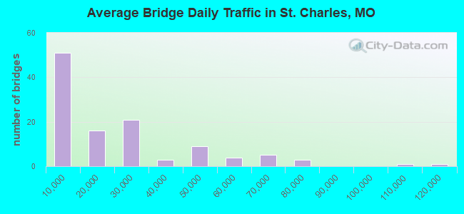
- 2,331,661Total average daily traffic
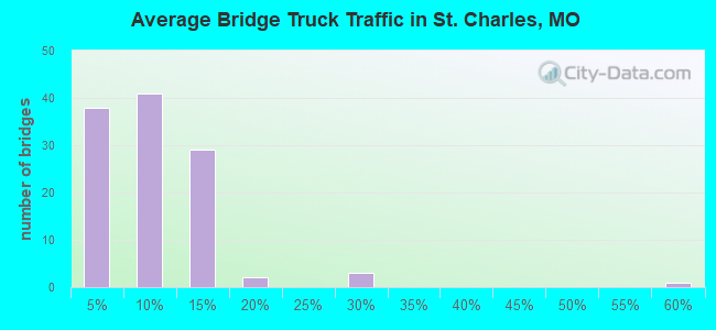
- 214,382Total average daily truck traffic
- National Bridge Inventory (NBI) Registered Bridges for St. Charles
- No street view available for this location
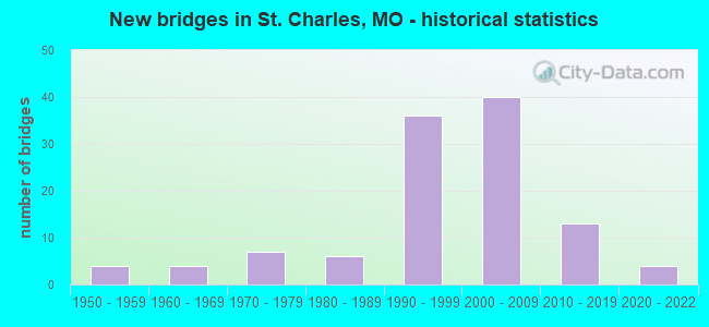
- New bridges - historical statistics
- 41950-1959
- 41960-1969
- 71970-1979
- 61980-1989
- 361990-1999
- 402000-2009
- 132010-2019
- 42020-2022
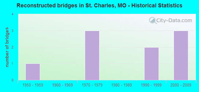
- Reconstructed bridges - Historical Statistics
- 11950-1959
- 01960-1969
- 31970-1979
- 01980-1989
- 21990-1999
- 32000-2009
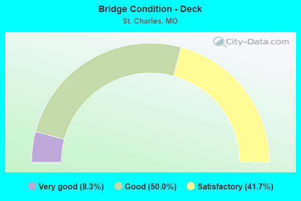
- Bridge Condition - Deck
- 8.3%Very good
- 50.0%Good
- 41.7%Satisfactory
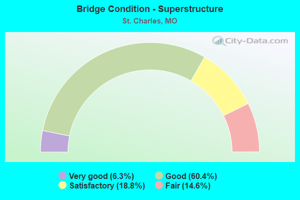
- Bridge Condition - Superstructure
- 6.3%Very good
- 60.4%Good
- 18.8%Satisfactory
- 14.6%Fair
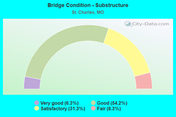
- Bridge Condition - Substructure
- 6.3%Very good
- 54.2%Good
- 31.3%Satisfactory
- 8.3%Fair
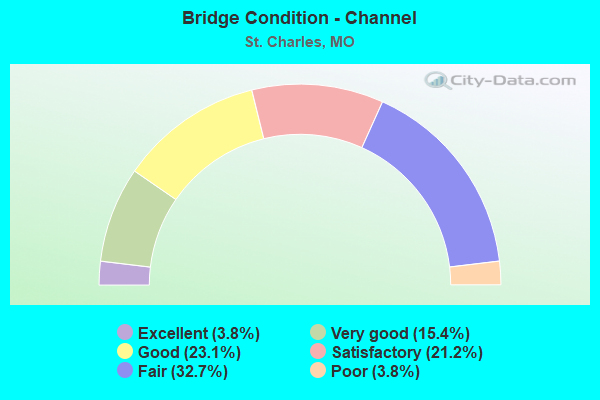
- Bridge Condition - Channel
- 3.8%Excellent
- 15.4%Very good
- 23.1%Good
- 21.2%Satisfactory
- 32.7%Fair
- 3.8%Poor
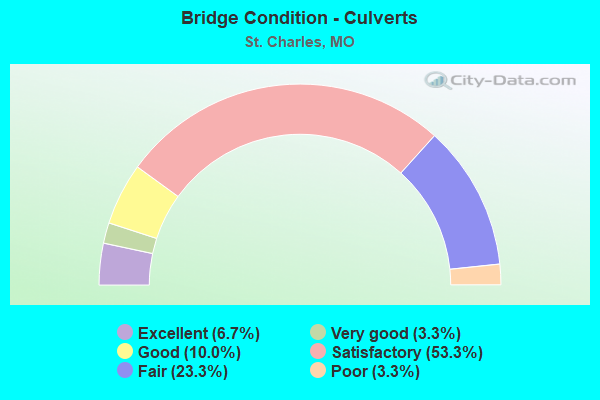
- Bridge Condition - Culverts
- 6.7%Excellent
- 3.3%Very good
- 10.0%Good
- 53.3%Satisfactory
- 23.3%Fair
- 3.3%Poor
Find on map >> Show street view
Structure Number: 34635, Location: S 1000 T 47 N R 5 E (Lat: 38.833667, Lng: -90.490111), Route carried "on" structure: City street , Year Built: 2009, Status: Open, Structure Length: 1.52m (4.99ft), Average Daily Traffic: 400 (year 2020), Truck Traffic: 2%, Average Future Daily Traffic: 620 (year 2040), Design Load: HS 20, Features Intersected: CANAL, Facility Carried by Structure: SB GRANGER BLVD
Minimum Vertical Clearance: 30+ m (98+ ft), Kilometerpoint: 0.000, Lanes on structure: 1, Owner: City or Municipal Highway Agency, Approaching Roadway Width: 6.1m (20.0ft), Skew: 20 degrees, Material/Design: Steel, Design/Construction: Stringer/Multi-beam, Number Of Spans In Main Unit: 1, Length of Maximum Span: 14.9m (48.9ft), Curb or Sidewalk Widths: Left: 1.8m (5.9ft), Right: 2.4m (7.9ft), Curb-To-Curb Width: 7.9m (25.9ft), Out-to-Out Width: 7.9m (25.9ft)
Condition: Deck: Satisfactory, Superstructure: Good, Substructure: Satisfactory, Channel: Good, Operating Rating: 75.6 metric tons, Method Used To Determine Operating Rating: Load Factor (LF), Inventory Rating: 45.0 metric tons, Method Used To Determine Inventory Rating: Load Factor (LF), Structural Evaluation: Equal to present minimum criteria, Deck Geometry: Somewhat better than minimum adequacy, Waterway Adequacy: Superior to present desirable criteria, Approach Roadway Alignment: Equal to present desirable criteria, Designated Inspection Frequency: Every 24 months, Inspection Date: January 2022, Deck Structure Type: Concrete Cast-file-Place
Find on map >> Show street view
Structure Number: 34636, Location: S 1000 T 47 N R 5 E (Lat: 38.833500, Lng: -90.489972), Route carried "on" structure: City street , Year Built: 2009, Status: Open, Structure Length: 1.52m (4.99ft), Average Daily Traffic: 400 (year 2020), Truck Traffic: 2%, Average Future Daily Traffic: 620 (year 2040), Design Load: HS 20, Features Intersected: CANAL, Facility Carried by Structure: NB GRANGER BLVD
Minimum Vertical Clearance: 30+ m (98+ ft), Kilometerpoint: 0.000, Lanes on structure: 1, Owner: City or Municipal Highway Agency, Approaching Roadway Width: 6.1m (20.0ft), Material/Design: Steel, Design/Construction: Stringer/Multi-beam, Number Of Spans In Main Unit: 1, Length of Maximum Span: 14.9m (48.9ft), Curb or Sidewalk Widths: Left: 1.8m (5.9ft), Right: 2.4m (7.9ft), Curb-To-Curb Width: 7.9m (25.9ft), Out-to-Out Width: 7.9m (25.9ft)
Condition: Deck: Good, Superstructure: Good, Substructure: Satisfactory, Channel: Good, Operating Rating: 62.1 metric tons, Method Used To Determine Operating Rating: Load Factor (LF), Inventory Rating: 36.9 metric tons, Method Used To Determine Inventory Rating: Load Factor (LF), Structural Evaluation: Equal to present minimum criteria, Deck Geometry: Somewhat better than minimum adequacy, Waterway Adequacy: Superior to present desirable criteria, Approach Roadway Alignment: Equal to present desirable criteria, Designated Inspection Frequency: Every 24 months, Inspection Date: January 2022, Deck Structure Type: Concrete Cast-file-Place
Find on map >> Show street view
Structure Number: 34637, Location: S 1000 T 47 N R 5 E (Lat: 38.830461, Lng: -90.487642), Route carried "on" structure: City street , Year Built: 2009, Status: Open, Structure Length: 1.52m (4.99ft), Average Daily Traffic: 400 (year 2020), Truck Traffic: 2%, Average Future Daily Traffic: 620 (year 2040), Design Load: HS 20, Features Intersected: CANAL, Facility Carried by Structure: SIMEON BUNKER ST.
Minimum Vertical Clearance: 30+ m (98+ ft), Kilometerpoint: 0.000, Lanes on structure: 2, Owner: City or Municipal Highway Agency, Approaching Roadway Width: 6.1m (20.0ft), Material/Design: Steel, Design/Construction: Stringer/Multi-beam, Number Of Spans In Main Unit: 1, Length of Maximum Span: 14.9m (48.9ft), Curb or Sidewalk Widths: Left: 2.4m (7.9ft), Right: 2.4m (7.9ft), Curb-To-Curb Width: 11.0m (36.1ft), Out-to-Out Width: 11.0m (36.1ft)
Condition: Deck: Very good, Superstructure: Satisfactory, Substructure: Satisfactory, Channel: Good, Operating Rating: 84.6 metric tons, Method Used To Determine Operating Rating: Load Factor (LF), Inventory Rating: 50.4 metric tons, Method Used To Determine Inventory Rating: Load Factor (LF), Structural Evaluation: Equal to present minimum criteria, Deck Geometry: Equal to present desirable criteria, Waterway Adequacy: Superior to present desirable criteria, Approach Roadway Alignment: Equal to present minimum criteria, Designated Inspection Frequency: Every 24 months, Inspection Date: January 2022, Deck Structure Type: Open Grating
Find on map >> Show street view
Structure Number: 34638, Location: S 1000 T 47 N R 5 E (Lat: 38.836039, Lng: -90.486144), Route carried "on" structure: City street , Year Built: 2009, Status: Open, Structure Length: 1.52m (4.99ft), Average Daily Traffic: 1,200 (year 2020), Truck Traffic: 2%, Average Future Daily Traffic: 1,860 (year 2040), Design Load: HS 20, Features Intersected: CANAL, Facility Carried by Structure: BARTAR STREET
Minimum Vertical Clearance: 30+ m (98+ ft), Kilometerpoint: 0.000, Lanes on structure: 2, Owner: City or Municipal Highway Agency, Approaching Roadway Width: 6.1m (20.0ft), Material/Design: Steel, Design/Construction: Stringer/Multi-beam, Number Of Spans In Main Unit: 1, Length of Maximum Span: 14.9m (48.9ft), Curb or Sidewalk Widths: Left: 2.4m (7.9ft), Right: 2.4m (7.9ft), Curb-To-Curb Width: 11.0m (36.1ft), Out-to-Out Width: 11.0m (36.1ft)
Condition: Deck: Good, Superstructure: Good, Substructure: Satisfactory, Channel: Satisfactory, Operating Rating: 63.0 metric tons, Method Used To Determine Operating Rating: Load Factor (LF), Inventory Rating: 37.8 metric tons, Method Used To Determine Inventory Rating: Load Factor (LF), Structural Evaluation: Equal to present minimum criteria, Deck Geometry: Equal to present minimum criteria, Waterway Adequacy: Superior to present desirable criteria, Approach Roadway Alignment: Equal to present desirable criteria, Designated Inspection Frequency: Every 24 months, Inspection Date: January 2022, Deck Structure Type: Open Grating
Find on map >> Show street view
Structure Number: 34639, Location: S 1000 T 47 N R 5 E (Lat: 38.831694, Lng: -90.480861), Route carried "on" structure: City street , Year Built: 2009, Status: Open, Structure Length: 1.52m (4.99ft), Average Daily Traffic: 1,200 (year 2020), Truck Traffic: 2%, Average Future Daily Traffic: 1,860 (year 2040), Design Load: HS 20, Features Intersected: CANAL, Facility Carried by Structure: ISLAND HARBOR DR.
Minimum Vertical Clearance: 30+ m (98+ ft), Kilometerpoint: 0.000, Lanes on structure: 2, Owner: City or Municipal Highway Agency, Approaching Roadway Width: 6.1m (20.0ft), Material/Design: Steel, Design/Construction: Stringer/Multi-beam, Number Of Spans In Main Unit: 1, Length of Maximum Span: 14.9m (48.9ft), Curb or Sidewalk Widths: Left: 2.4m (7.9ft), Right: 2.4m (7.9ft), Curb-To-Curb Width: 11.0m (36.1ft), Out-to-Out Width: 11.0m (36.1ft)
Condition: Deck: Very good, Superstructure: Good, Substructure: Good, Channel: Very good, Operating Rating: 86.4 metric tons, Method Used To Determine Operating Rating: Load Factor (LF), Inventory Rating: 51.3 metric tons, Method Used To Determine Inventory Rating: Load Factor (LF), Structural Evaluation: Better than present minimum criteria, Deck Geometry: Equal to present minimum criteria, Waterway Adequacy: Superior to present desirable criteria, Approach Roadway Alignment: Equal to present minimum criteria, Designated Inspection Frequency: Every 24 months, Inspection Date: January 2022, Deck Structure Type: Open Grating
Find on map >> Show street view
Structure Number: 35182, Location: S 3280 T 46 N R 5 E (Lat: 38.770939, Lng: -90.500358), Route carried "on" structure: City street , Year Built: 2016, Status: Open, Structure Length: 5.44m (17.85ft), Average Daily Traffic: 7,000 (year 2021), Truck Traffic: 2%, Average Future Daily Traffic: 13,650 (year 2041), Features Intersected: IS 70, Facility Carried by Structure: CONVENTION CENTER
Minimum Vertical Clearance: 5.05m (16.57ft), Kilometerpoint: 0.425, Lanes on structure: 4, Lanes under structure: 10, Owner: State Highway Agency, Approaching Roadway Width: 18.3m (60.0ft), Material/Design: Prestressed concrete continuous, Design/Construction: Tee Beam, Number Of Spans In Main Unit: 2, Length of Maximum Span: 26.7m (87.6ft), Curb-To-Curb Width: 18.3m (60.0ft), Out-to-Out Width: 22.5m (73.8ft)
Condition: Deck: Good, Superstructure: Good, Substructure: Good, Operating Rating: 63.9 metric tons, Method Used To Determine Operating Rating: Load Factor (LF), Inventory Rating: 22.5 metric tons, Method Used To Determine Inventory Rating: Load Factor (LF), Structural Evaluation: Somewhat better than minimum adequacy, Deck Geometry: Somewhat better than minimum adequacy, Underclear: Equal to present minimum criteria, Approach Roadway Alignment: Equal to present desirable criteria, Designated Inspection Frequency: Every 24 months, Inspection Date: October 2021, Deck Structure Type: Concrete Cast-file-Place, Wearing Surface/Protective System: Wearing Surface: Monolithic Concrete, Deck Protection: Epoxy Coated Reinforcing
Find on map >> Show street view
Structure Number: 35183, Location: S 328 T 46 N R 5 E (Lat: 38.769567, Lng: -90.498572), Route carried "on" structure: Ramp State highway , Year Built: 2016, Status: Open, Structure Length: 2.90m (9.51ft), Average Daily Traffic: 5,378 (year 2020), Truck Traffic: 3%, Average Future Daily Traffic: 9,143 (year 2040), Features Intersected: RP FAIRGROUNDS RD TO IS7, Facility Carried by Structure: RP IS70E TO LP70E
Minimum Vertical Clearance: 5.05m (16.57ft), Kilometerpoint: 0.177, Lanes on structure: 1, Lanes under structure: 1, Base Highway Network: Yes, Owner: State Highway Agency, Approaching Roadway Width: 7.9m (25.9ft), Skew: 5 degrees, Material/Design: Prestressed concrete, Design/Construction: Tee Beam, Number Of Spans In Main Unit: 1, Length of Maximum Span: 24.7m (81.0ft), Curb-To-Curb Width: 7.9m (25.9ft), Out-to-Out Width: 8.8m (28.9ft)
Condition: Deck: Good, Superstructure: Good, Substructure: Good, Inventory Rating: 47.7 metric tons, Method Used To Determine Inventory Rating: Load Factor (LF), Structural Evaluation: Better than present minimum criteria, Deck Geometry: Equal to present minimum criteria, Underclear: Superior to present desirable criteria, Approach Roadway Alignment: Equal to present desirable criteria, Designated Inspection Frequency: Every 24 months, Inspection Date: October 2021, Deck Structure Type: Concrete Cast-file-Place, Wearing Surface/Protective System: Wearing Surface: Monolithic Concrete, Deck Protection: Epoxy Coated Reinforcing
Find on map >> Show street view
Structure Number: 35386, Location: S 1 T 47 N R 4 E (Lat: 38.864842, Lng: -90.516667), Route carried "on" structure: County highway 14100, Year Built: 2017, Status: Open, Structure Length: 1.00m (3.28ft), Average Daily Traffic: 292 (year 2020), Truck Traffic: 10%, Average Future Daily Traffic: 642 (year 2040), Design Load: HS 20, Features Intersected: TRIB OF MISSISSIPP, Facility Carried by Structure: S SHORE DR
Minimum Vertical Clearance: 30+ m (98+ ft), Kilometerpoint: 0.563, Lanes on structure: 2, Owner: County Highway Agency, Approaching Roadway Width: 9.1m (29.9ft), Skew: 2 degrees, Material/Design: Concrete, Design/Construction: Culvert, Number Of Spans In Main Unit: 2, Length of Maximum Span: 4.7m (15.4ft), Curb-To-Curb Width: 12.2m (40.0ft), Out-to-Out Width: 12.2m (40.0ft)
Condition: Channel: Satisfactory, Culverts: Satisfactory, Operating Rating: 50.4 metric tons, Method Used To Determine Operating Rating: Load Factor (LF), Inventory Rating: 38.7 metric tons, Method Used To Determine Inventory Rating: Load Factor (LF), Structural Evaluation: Equal to present minimum criteria, Deck Geometry: Superior to present desirable criteria, Waterway Adequacy: Better than present minimum criteria, Approach Roadway Alignment: Better than present minimum criteria, Designated Inspection Frequency: Every 24 months, Inspection Date: Febuary 2022, Deck Structure Type: Concrete Cast-file-Place, Wearing Surface/Protective System: Wearing Surface: Bituminous
Find on map >> Show street view
Structure Number: 35644, Location: S 29 T 46 N R 4 E (Lat: 38.708861, Lng: -90.589081), Route carried "on" structure: County highway 241, Year Built: 2017, Status: Open, Structure Length: 0.80m (2.62ft), Average Daily Traffic: 851 (year 2020), Truck Traffic: 8%, Average Future Daily Traffic: 1,319 (year 2040), Design Load: HS 20, Features Intersected: TRIB, Facility Carried by Structure: GREENS BOTTOM RD
Minimum Vertical Clearance: 30+ m (98+ ft), Kilometerpoint: 0.161, Lanes on structure: 2, Owner: County Highway Agency, Approaching Roadway Width: 10.0m (32.8ft), Material/Design: Concrete, Design/Construction: Culvert, Number Of Spans In Main Unit: 2, Length of Maximum Span: 3.7m (12.1ft), Curb-To-Curb Width: 9.4m (30.8ft), Out-to-Out Width: 10.4m (34.1ft)
Condition: Channel: Satisfactory, Culverts: Satisfactory, Operating Rating: 59.4 metric tons, Method Used To Determine Operating Rating: Load Factor (LF), Inventory Rating: 35.1 metric tons, Method Used To Determine Inventory Rating: Load Factor (LF), Structural Evaluation: Equal to present minimum criteria, Deck Geometry: Equal to present minimum criteria, Waterway Adequacy: Superior to present desirable criteria, Approach Roadway Alignment: Equal to present desirable criteria, Designated Inspection Frequency: Every 24 months, Inspection Date: Febuary 2022
Find on map >> Show street view
Structure Number: 36261, Location: S 2892 T 46 N R 5 E (Lat: 38.763361, Lng: -90.499917), Route carried "on" structure: City street , Year Built: 2018, Status: Open, Structure Length: 0.76m (2.49ft), Average Daily Traffic: 1,100 (year 2020), Truck Traffic: 2%, Average Future Daily Traffic: 1,705 (year 2040), Features Intersected: CRYSTAL SPRINGS CR, Facility Carried by Structure: RIO VISTA DR
Minimum Vertical Clearance: 30+ m (98+ ft), Kilometerpoint: 0.000, Lanes on structure: 2, Owner: City or Municipal Highway Agency, Approaching Roadway Width: 10.5m (34.4ft), Material/Design: Concrete, Design/Construction: Culvert, Number Of Spans In Main Unit: 2, Length of Maximum Span: 3.7m (12.1ft)
Condition: Channel: Satisfactory, Culverts: Satisfactory, Inventory Rating: 81.9 metric tons, Method Used To Determine Inventory Rating: Load Factor (LF), Structural Evaluation: Equal to present minimum criteria, Waterway Adequacy: Superior to present desirable criteria, Approach Roadway Alignment: Better than present minimum criteria, Designated Inspection Frequency: Every 24 months, Inspection Date: January 2022
Find on map >> Show street view
Structure Number: 36262, Location: S 2892 T 46 N R 5 E (Lat: 38.763528, Lng: -90.502611), Route carried "on" structure: City street , Year Built: 2018, Status: Open, Structure Length: 0.90m (2.95ft), Average Daily Traffic: 2,500 (year 2020), Truck Traffic: 7%, Average Future Daily Traffic: 3,875 (year 2040), Design Load: HS 20, Features Intersected: CRYSTAL SPRINGS CR, Facility Carried by Structure: S 5TH ST
Minimum Vertical Clearance: 30+ m (98+ ft), Kilometerpoint: 0.000, Lanes on structure: 2, Owner: City or Municipal Highway Agency, Approaching Roadway Width: 10.2m (33.5ft), Skew: 4 degrees, Material/Design: Concrete, Design/Construction: Culvert, Number Of Spans In Main Unit: 2, Length of Maximum Span: 4.4m (14.4ft), Curb or Sidewalk Widths: Left: 1.5m (4.9ft), Right: 1.5m (4.9ft)
Condition: Channel: Good, Culverts: Satisfactory, Inventory Rating: 97.2 metric tons, Method Used To Determine Inventory Rating: Load Factor (LF), Structural Evaluation: Equal to present minimum criteria, Waterway Adequacy: Superior to present desirable criteria, Approach Roadway Alignment: Equal to present desirable criteria, Designated Inspection Frequency: Every 24 months, Inspection Date: January 2022
Find on map >> Show street view
Structure Number: 36263, Location: S 24 T 47 N R 4 E (Lat: 38.811111, Lng: -90.516111), Route carried "on" structure: City street , Year Built: 2019, Status: Open, Structure Length: 3.43m (11.25ft), Average Daily Traffic: 1,530 (year 2020), Truck Traffic: 2%, Average Future Daily Traffic: 2,372 (year 2040), Design Load: HS 20, Features Intersected: COLE CR, Facility Carried by Structure: RUNNYMEADE DR
Minimum Vertical Clearance: 30+ m (98+ ft), Kilometerpoint: 0.000, Lanes on structure: 2, Owner: City or Municipal Highway Agency, Approaching Roadway Width: 9.8m (32.2ft), Material/Design: Concrete continuous, Design/Construction: Slab, Number Of Spans In Main Unit: 3, Length of Maximum Span: 12.2m (40.0ft), Curb or Sidewalk Widths: Left: 1.5m (4.9ft), Right: 1.5m (4.9ft), Curb-To-Curb Width: 9.8m (32.2ft), Out-to-Out Width: 14.1m (46.3ft)
Condition: Deck: Good, Superstructure: Good, Substructure: Good, Channel: Very good, Operating Rating: 66.6 metric tons, Method Used To Determine Operating Rating: Load Factor (LF), Inventory Rating: 39.6 metric tons, Method Used To Determine Inventory Rating: Load Factor (LF), Structural Evaluation: Better than present minimum criteria, Deck Geometry: Somewhat better than minimum adequacy, Waterway Adequacy: Superior to present desirable criteria, Approach Roadway Alignment: Better than present minimum criteria, Designated Inspection Frequency: Every 24 months, Inspection Date: January 2022, Deck Structure Type: Concrete Cast-file-Place, Wearing Surface/Protective System: Wearing Surface: Monolithic Concrete, Deck Protection: Epoxy Coated Reinforcing
Find on map >> Show street view
Structure Number: 36264, Location: S 24 T 47 N R 4 E (Lat: 38.816944, Lng: -90.513611), Route carried "on" structure: City street , Year Built: 2019, Status: Open, Structure Length: 3.99m (13.09ft), Average Daily Traffic: 4,000 (year 2020), Truck Traffic: 10%, Average Future Daily Traffic: 6,200 (year 2040), Design Load: HS 20, Features Intersected: COLE CR, Facility Carried by Structure: ELM POINT RD
Minimum Vertical Clearance: 30+ m (98+ ft), Kilometerpoint: 0.000, Lanes on structure: 2, Owner: City or Municipal Highway Agency, Approaching Roadway Width: 8.5m (27.9ft), Skew: 3 degrees, Material/Design: Concrete, Design/Construction: Slab, Number Of Spans In Main Unit: 4, Length of Maximum Span: 10.4m (34.1ft), Curb-To-Curb Width: 8.5m (27.9ft), Out-to-Out Width: 9.4m (30.8ft)
Condition: Deck: Very good, Superstructure: Very good, Substructure: Very good, Channel: Good, Operating Rating: 68.4 metric tons, Method Used To Determine Operating Rating: Load Factor (LF), Inventory Rating: 41.4 metric tons, Method Used To Determine Inventory Rating: Load Factor (LF), Structural Evaluation: Equal to present desirable criteria, Deck Geometry: Meets minimum limits, Waterway Adequacy: Equal to present desirable criteria, Approach Roadway Alignment: Equal to present desirable criteria, Designated Inspection Frequency: Every 24 months, Inspection Date: January 2022, Deck Structure Type: Concrete Cast-file-Place, Wearing Surface/Protective System: Wearing Surface: Monolithic Concrete, Deck Protection: Epoxy Coated Reinforcing
Find on map >> Show street view
Structure Number: 36265, Location: S 2892 T 47 N R 5 E (Lat: 38.793222, Lng: -90.497972), Route carried "on" structure: City street , Year Built: 2018, Status: Open, Structure Length: 0.72m (2.36ft), Average Daily Traffic: 20,500 (year 2020), Truck Traffic: 10%, Average Future Daily Traffic: 31,775 (year 2040), Design Load: HS 20, Features Intersected: BOSCHERT CR, Facility Carried by Structure: ELM ST
Minimum Vertical Clearance: 30+ m (98+ ft), Kilometerpoint: 0.000, Lanes on structure: 3, Owner: City or Municipal Highway Agency, Approaching Roadway Width: 11.0m (36.1ft), Material/Design: Concrete, Design/Construction: Culvert, Number Of Spans In Main Unit: 2, Length of Maximum Span: 3.4m (11.2ft), Curb or Sidewalk Widths: Left: 1.5m (4.9ft), Right: 0.0m, Curb-To-Curb Width: 11.0m (36.1ft), Out-to-Out Width: 17.7m (58.1ft)
Condition: Channel: Satisfactory, Culverts: Satisfactory, Inventory Rating: 80.1 metric tons, Method Used To Determine Inventory Rating: Load Factor (LF), Structural Evaluation: Equal to present minimum criteria, Deck Geometry: High priority of replacement, Waterway Adequacy: Superior to present desirable criteria, Approach Roadway Alignment: Equal to present desirable criteria, Designated Inspection Frequency: Every 24 months, Inspection Date: January 2022
Find on map >> Show street view
Structure Number: 36266, Location: S 2892 T 46 N R 5 E (Lat: 38.804722, Lng: -90.495556), Route carried "on" structure: City street , Year Built: 2019, Status: Open, Structure Length: 0.70m (2.30ft), Average Daily Traffic: 2,700 (year 2020), Truck Traffic: 2%, Average Future Daily Traffic: 4,185 (year 2040), Design Load: HS 20, Features Intersected: BOSCHERT CR, Facility Carried by Structure: CONCORDIA LN
Minimum Vertical Clearance: 30+ m (98+ ft), Kilometerpoint: 0.000, Lanes on structure: 2, Owner: City or Municipal Highway Agency, Approaching Roadway Width: 10.2m (33.5ft), Material/Design: Concrete, Design/Construction: Culvert, Number Of Spans In Main Unit: 2, Length of Maximum Span: 3.4m (11.2ft), Curb or Sidewalk Widths: Left: 1.5m (4.9ft), Right: 1.5m (4.9ft)
Condition: Channel: Good, Culverts: Satisfactory, Structural Evaluation: Equal to present minimum criteria, Waterway Adequacy: Superior to present desirable criteria, Approach Roadway Alignment: Equal to present desirable criteria, Designated Inspection Frequency: Every 24 months, Inspection Date: January 2022
Find on map >> Show street view
Structure Number: 36267, Location: S 2892 T 47 N R 5 E (Lat: 38.792361, Lng: -90.499111), Route carried "on" structure: City street , Year Built: 2019, Status: Open, Structure Length: 0.64m (2.10ft), Average Daily Traffic: 3,100 (year 2020), Truck Traffic: 5%, Average Future Daily Traffic: 4,805 (year 2040), Features Intersected: BOSCHERT CR, Facility Carried by Structure: SIBLEY SST
Minimum Vertical Clearance: 30+ m (98+ ft), Kilometerpoint: 0.000, Lanes on structure: 2, Owner: City or Municipal Highway Agency, Approaching Roadway Width: 10.9m (35.8ft), Skew: 3 degrees, Material/Design: Concrete, Design/Construction: Culvert, Number Of Spans In Main Unit: 1, Length of Maximum Span: 6.1m (20.0ft)
Condition: Channel: Good, Culverts: Good, Inventory Rating: 80.1 metric tons, Method Used To Determine Inventory Rating: Load Factor (LF), Structural Evaluation: Better than present minimum criteria, Waterway Adequacy: Superior to present desirable criteria, Approach Roadway Alignment: Equal to present desirable criteria, Designated Inspection Frequency: Every 24 months, Inspection Date: January 2022
Find on map >> Show street view
Structure Number: 36341, Location: S 2982 T 46 N R 5 E (Lat: 38.764833, Lng: -90.503750), Route carried "on" structure: City street , Year Built: 2020, Status: Open, Structure Length: 3.12m (10.24ft), Average Daily Traffic: 3,400 (year 2020), Truck Traffic: 8%, Average Future Daily Traffic: 5,270 (year 2040), Design Load: HS 20, Features Intersected: CRYSTAL SPRINGS CR, Facility Carried by Structure: CONVENTION CTR BLV
Minimum Vertical Clearance: 30+ m (98+ ft), Kilometerpoint: 0.000, Lanes on structure: 2, Owner: City or Municipal Highway Agency, Approaching Roadway Width: 9.1m (29.9ft), Material/Design: Prestressed concrete, Design/Construction: Tee Beam, Number Of Spans In Main Unit: 1, Length of Maximum Span: 30.5m (100.1ft), Curb or Sidewalk Widths: Left: 3.6m (11.8ft), Right: 0.0m, Curb-To-Curb Width: 9.1m (29.9ft), Out-to-Out Width: 13.7m (44.9ft)
Condition: Deck: Good, Superstructure: Very good, Substructure: Very good, Channel: Fair, Operating Rating: 92.7 metric tons, Method Used To Determine Operating Rating: Load Factor (LF), Inventory Rating: 42.3 metric tons, Method Used To Determine Inventory Rating: Load Factor (LF), Structural Evaluation: Equal to present desirable criteria, Deck Geometry: Meets minimum limits, Waterway Adequacy: Superior to present desirable criteria, Approach Roadway Alignment: Equal to present minimum criteria, Designated Inspection Frequency: Every 24 months, Inspection Date: January 2022, Deck Structure Type: Concrete Cast-file-Place, Wearing Surface/Protective System: Deck Protection: Epoxy Coated Reinforcing
Find on map >> Show street view
Structure Number: 36392, Location: S 13 T 47 N R 4 E (Lat: 38.832908, Lng: -90.517281), Route carried "on" structure: City street , Year Built: 2020, Status: Open, Structure Length: 2.01m (6.59ft), Average Daily Traffic: 1,000 (year 2020), Truck Traffic: 25%, Average Future Daily Traffic: 1,550 (year 2040), Design Load: HS 20, Features Intersected: TRIB MISSISSIPPI R, Facility Carried by Structure: SKINNER INDSTRL DR
Minimum Vertical Clearance: 30+ m (98+ ft), Kilometerpoint: 0.000, Lanes on structure: 2, Owner: City or Municipal Highway Agency, Approaching Roadway Width: 14.0m (45.9ft), Skew: 1 degrees, Material/Design: Concrete, Design/Construction: Culvert, Number Of Spans In Main Unit: 3, Length of Maximum Span: 6.4m (21.0ft), Curb or Sidewalk Widths: Left: 1.5m (4.9ft), Right: 0.0m
Condition: Channel: Very good, Culverts: Satisfactory, Operating Rating: 81.0 metric tons, Method Used To Determine Operating Rating: Load Factor (LF), Inventory Rating: 48.6 metric tons, Method Used To Determine Inventory Rating: Load Factor (LF), Structural Evaluation: Equal to present minimum criteria, Waterway Adequacy: Superior to present desirable criteria, Approach Roadway Alignment: Equal to present desirable criteria, Designated Inspection Frequency: Every 24 months, Inspection Date: January 2022
Find on map >> Show street view
Structure Number: 36414, Location: S 6 T 47 N R 5 E (Lat: 38.860833, Lng: -90.510556), Route carried "on" structure: County highway 96, Year Built: 2020, Status: Open, Structure Length: 0.91m (2.99ft), Average Daily Traffic: 569 (year 2020), Truck Traffic: 10%, Average Future Daily Traffic: 882 (year 2040), Design Load: HS 20, Features Intersected: TRIB OF MISS RVR, Facility Carried by Structure: SEEBURGER RD
Minimum Vertical Clearance: 30+ m (98+ ft), Kilometerpoint: 2.736, Lanes on structure: 2, Owner: County Highway Agency, Approaching Roadway Width: 9.1m (29.9ft), Skew: 3 degrees, Material/Design: Concrete continuous, Design/Construction: Culvert, Number Of Spans In Main Unit: 3, Length of Maximum Span: 2.8m (9.2ft), Curb-To-Curb Width: 14.9m (48.9ft), Out-to-Out Width: 15.6m (51.2ft)
Condition: Channel: Excellent, Culverts: Excellent, Operating Rating: 50.4 metric tons, Method Used To Determine Operating Rating: Load Factor (LF), Inventory Rating: 38.7 metric tons, Method Used To Determine Inventory Rating: Load Factor (LF), Structural Evaluation: Superior to present desirable criteria, Deck Geometry: Superior to present desirable criteria, Waterway Adequacy: Equal to present desirable criteria, Approach Roadway Alignment: Equal to present desirable criteria, Designated Inspection Frequency: Every 24 months, Inspection Date: Febuary 2022, Deck Structure Type: Concrete Cast-file-Place, Wearing Surface/Protective System: Wearing Surface: Monolithic Concrete
Find on map >> Show street view
Structure Number: 36702, Location: S 3280 T 47 N R 4 E (Lat: 38.781933, Lng: -90.532353), Route carried "on" structure: City street 383, Year Built: 2022, Status: Not yet open, Structure Length: 1.70m (5.58ft), Average Daily Traffic: 20,000 (year 2021), Truck Traffic: 15%, Average Future Daily Traffic: 31,000 (year 2041), Design Load: HS 20, Features Intersected: TRIB OF COLE CR, Facility Carried by Structure: ZUMBEHL ROAD
Minimum Vertical Clearance: 30+ m (98+ ft), Kilometerpoint: 0.644, Lanes on structure: 5, Owner: City or Municipal Highway Agency, Approaching Roadway Width: 20.4m (66.9ft), Skew: 3 degrees, Material/Design: Concrete continuous, Design/Construction: Culvert, Number Of Spans In Main Unit: 4, Length of Maximum Span: 4.0m (13.1ft), Curb or Sidewalk Widths: Left: 1.5m (4.9ft), Right: 3.0m (9.8ft), Curb-To-Curb Width: 60.7m (199.1ft), Out-to-Out Width: 76.5m (251.0ft)
Condition: Channel: Excellent, Culverts: Excellent, Operating Rating: 97.2 metric tons, Method Used To Determine Operating Rating: Load Factor (LF), Inventory Rating: 74.7 metric tons, Method Used To Determine Inventory Rating: Load Factor (LF), Structural Evaluation: Superior to present desirable criteria, Deck Geometry: Superior to present desirable criteria, Waterway Adequacy: Equal to present desirable criteria, Approach Roadway Alignment: Equal to present desirable criteria, Designated Inspection Frequency: Every 24 months, Inspection Date: January 2022
Find on map >> Show street view
Structure Number: 3729, Location: S 32 T 47 N R 5 E (Lat: 38.798108, Lng: -90.466814), Route carried "on" structure: State highway 370, Year Built: 1992, Status: Open, Structure Length: 105.31m (345.51ft), Average Daily Traffic: 25,313 (year 2021), Truck Traffic: 5%, Average Future Daily Traffic: 43,032 (year 2041), Design Load: HS 20+Mod, Features Intersected: MISSOURI RVR, CST MAIN S
Minimum Vertical Clearance: 5.03m (16.50ft), Kilometerpoint: 13.123, Lanes on structure: 3, Lanes under structure: 2, Base Highway Network: Yes, Owner: State Highway Agency, Approaching Roadway Width: 17.1m (56.1ft), Navigation Control: Yes ( Vertical Clearance: 15.8m (51.8ft), Horizontal Clearance: 188.1m (617.1ft)), Material/Design: Steel, Design/Construction: Truss - Thru, Number Of Spans In Main Unit: 1, Number Of Approach Spans: 22, Length of Maximum Span: 190.5m (625.0ft), Curb or Sidewalk Widths: Left: 0.2m (0.7ft), Right: 0.2m (0.7ft), Curb-To-Curb Width: 16.7m (54.8ft), Out-to-Out Width: 17.5m (57.4ft)
Condition: Deck: Good, Superstructure: Satisfactory, Substructure: Fair, Channel: Very good, Operating Rating: 47.7 metric tons, Method Used To Determine Operating Rating: Load Factor (LF), Inventory Rating: 28.8 metric tons, Method Used To Determine Inventory Rating: Load Factor (LF), Structural Evaluation: Somewhat better than minimum adequacy, Deck Geometry: Equal to present minimum criteria, Underclear: Somewhat better than minimum adequacy, Waterway Adequacy: Equal to present desirable criteria, Approach Roadway Alignment: Equal to present desirable criteria, Designated Inspection Frequency: Every 24 months, Critical Feature Inspection Frequency: Every 24 months, Underwater Inspection Frequency: Every 60 months, Inspection Date: July 2021, Critical Feature Inspection Date: July 2021, Underwater Inspection Date: August 2021, Deck Structure Type: Concrete Cast-file-Place, Wearing Surface/Protective System: Wearing Surface: Low Slump Concrete, Deck Protection: Epoxy Coated Reinforcing
Find on map >> Show street view
Structure Number: 373, Location: S 12 T 27 N R 32 W (Lat: 37.078364, Lng: -94.376458), Route carried "on" structure: Interstate 44, Year Built: 1960, Year Reconstructed: 2003, Status: Open, Structure Length: 4.08m (13.39ft), Average Daily Traffic: 19,326 (year 2021), Truck Traffic: 28%, Average Future Daily Traffic: 34,787 (year 2041), Design Load: HS 20, Features Intersected: GROVE CR
Minimum Vertical Clearance: 30+ m (98+ ft), Kilometerpoint: 23.954, Lanes on structure: 2, Base Highway Network: Yes, Owner: State Highway Agency, Approaching Roadway Width: 11.6m (38.1ft), Skew: 1 degrees, Material/Design: Steel continuous, Design/Construction: Stringer/Multi-beam, Number Of Spans In Main Unit: 3, Length of Maximum Span: 15.2m (49.9ft), Curb-To-Curb Width: 12.2m (40.0ft), Out-to-Out Width: 13.0m (42.7ft)
Condition: Deck: Satisfactory, Superstructure: Good, Substructure: Satisfactory, Channel: Fair, Operating Rating: 70.2 metric tons, Method Used To Determine Operating Rating: Load Factor (LF), Inventory Rating: 42.3 metric tons, Method Used To Determine Inventory Rating: Load Factor (LF), Structural Evaluation: Equal to present minimum criteria, Deck Geometry: Better than present minimum criteria, Waterway Adequacy: Equal to present minimum criteria, Approach Roadway Alignment: Equal to present desirable criteria, Designated Inspection Frequency: Every 24 months, Inspection Date: August 2021, Deck Structure Type: Concrete Cast-file-Place, Wearing Surface/Protective System: Wearing Surface: Low Slump Concrete
Find on map >> Show street view
Structure Number: 373, Location: S 32 T 47 N R 5 E (Lat: 38.798203, Lng: -90.466647), Route carried "on" structure: State highway 370, Year Built: 1993, Status: Open, Structure Length: 105.31m (345.51ft), Average Daily Traffic: 25,213 (year 2021), Truck Traffic: 5%, Average Future Daily Traffic: 31,516 (year 2041), Design Load: HS 20+Mod, Features Intersected: MISSOURI RVR, CST MAIN S
Minimum Vertical Clearance: 5.03m (16.50ft), Kilometerpoint: 6.437, Lanes on structure: 3, Lanes under structure: 5, Base Highway Network: Yes, Owner: State Highway Agency, Approaching Roadway Width: 17.1m (56.1ft), Navigation Control: Yes ( Vertical Clearance: 15.8m (51.8ft), Horizontal Clearance: 188.1m (617.1ft)), Material/Design: Steel, Design/Construction: Truss - Thru, Number Of Spans In Main Unit: 1, Number Of Approach Spans: 22, Length of Maximum Span: 190.5m (625.0ft), Curb or Sidewalk Widths: Left: 3.0m (9.8ft), Right: 0.0m, Curb-To-Curb Width: 13.2m (43.3ft), Out-to-Out Width: 17.5m (57.4ft)
Condition: Deck: Good, Superstructure: Satisfactory, Substructure: Good, Channel: Very good, Operating Rating: 43.2 metric tons, Method Used To Determine Operating Rating: Load Factor (LF), Inventory Rating: 26.1 metric tons, Method Used To Determine Inventory Rating: Load Factor (LF), Structural Evaluation: Equal to present minimum criteria, Deck Geometry: Meets minimum limits, Underclear: Somewhat better than minimum adequacy, Waterway Adequacy: Equal to present desirable criteria, Approach Roadway Alignment: Equal to present desirable criteria, Designated Inspection Frequency: Every 24 months, Critical Feature Inspection Frequency: Every 24 months, Underwater Inspection Frequency: Every 60 months, Inspection Date: July 2021, Critical Feature Inspection Date: July 2021, Underwater Inspection Date: August 2021, Deck Structure Type: Concrete Cast-file-Place, Wearing Surface/Protective System: Wearing Surface: Low Slump Concrete, Deck Protection: Epoxy Coated Reinforcing
Find on map >> Show street view
Structure Number: 4043, Location: S 161 T 47 N R 5 E (Lat: 38.803119, Lng: -90.475350), Route carried "on" structure: State highway 370, Year Built: 1991, Status: Open, Structure Length: 7.13m (23.39ft), Average Daily Traffic: 20,604 (year 2021), Truck Traffic: 5%, Average Future Daily Traffic: 35,027 (year 2041), Design Load: HS 20+Mod, Features Intersected: MO 94
Minimum Vertical Clearance: 30+ m (98+ ft), Kilometerpoint: 12.649, Lanes on structure: 3, Lanes under structure: 5, Base Highway Network: Yes, Owner: State Highway Agency, Approaching Roadway Width: 17.4m (57.1ft), Skew: 3 degrees, Material/Design: Steel continuous, Design/Construction: Stringer/Multi-beam, Number Of Spans In Main Unit: 3, Length of Maximum Span: 36.3m (119.1ft), Curb or Sidewalk Widths: Left: 0.2m (0.7ft), Right: 0.2m (0.7ft), Curb-To-Curb Width: 16.7m (54.8ft), Out-to-Out Width: 17.6m (57.7ft)
Condition: Deck: Satisfactory, Superstructure: Good, Substructure: Good, Operating Rating: 68.4 metric tons, Method Used To Determine Operating Rating: Load Factor (LF), Inventory Rating: 40.5 metric tons, Method Used To Determine Inventory Rating: Load Factor (LF), Structural Evaluation: Better than present minimum criteria, Deck Geometry: Equal to present minimum criteria, Underclear: Equal to present minimum criteria, Approach Roadway Alignment: Equal to present desirable criteria, Designated Inspection Frequency: Every 24 months, Inspection Date: October 2021, Deck Structure Type: Concrete Cast-file-Place, Wearing Surface/Protective System: Wearing Surface: Latex Concrete, Deck Protection: Epoxy Coated Reinforcing
Find on map >> Show street view
Structure Number: 4058, Location: S 188 T 47 N R 5 E (Lat: 38.818575, Lng: -90.498483), Route carried "on" structure: State highway 370, Year Built: 1992, Status: Open, Structure Length: 1.15m (3.77ft), Average Daily Traffic: 42,017 (year 2021), Truck Traffic: 5%, Average Future Daily Traffic: 71,429 (year 2041), Design Load: HS 20+Mod, Features Intersected: BOSCHERT CR
Minimum Vertical Clearance: 30+ m (98+ ft), Kilometerpoint: 10.031, Lanes on structure: 6, Base Highway Network: Yes, Owner: State Highway Agency, Approaching Roadway Width: 34.7m (113.8ft), Skew: 4 degrees, Material/Design: Concrete continuous, Design/Construction: Culvert, Number Of Spans In Main Unit: 2, Length of Maximum Span: 4.3m (14.1ft)
Condition: Channel: Fair, Culverts: Satisfactory, Inventory Rating: 67.5 metric tons, Method Used To Determine Inventory Rating: Load Factor (LF), Structural Evaluation: Equal to present minimum criteria, Waterway Adequacy: Equal to present desirable criteria, Approach Roadway Alignment: Equal to present desirable criteria, Designated Inspection Frequency: Every 24 months, Inspection Date: November 2021
Find on map >> Show street view
Structure Number: 4113, Location: S 161 T 47 N R 5 E (Lat: 38.803336, Lng: -90.475300), Route carried "on" structure: State highway 370, Year Built: 1991, Status: Open, Structure Length: 15.39m (50.49ft), Average Daily Traffic: 25,213 (year 2021), Truck Traffic: 5%, Average Future Daily Traffic: 42,862 (year 2041), Design Load: HS 20+Mod, Features Intersected: MO 94
Minimum Vertical Clearance: 30+ m (98+ ft), Kilometerpoint: 7.778, Lanes on structure: 5, Lanes under structure: 5, Base Highway Network: Yes, Owner: State Highway Agency, Approaching Roadway Width: 17.4m (57.1ft), Skew: 2 degrees, Material/Design: Steel continuous, Design/Construction: Stringer/Multi-beam, Number Of Spans In Main Unit: 5, Length of Maximum Span: 36.3m (119.1ft), Curb or Sidewalk Widths: Left: 0.2m (0.7ft), Right: 0.2m (0.7ft), Curb-To-Curb Width: 19.8m (65.0ft), Out-to-Out Width: 20.6m (67.6ft)
Condition: Deck: Satisfactory, Superstructure: Fair, Substructure: Satisfactory, Operating Rating: 61.2 metric tons, Method Used To Determine Operating Rating: Load Factor (LF), Inventory Rating: 36.0 metric tons, Method Used To Determine Inventory Rating: Load Factor (LF), Structural Evaluation: Somewhat better than minimum adequacy, Deck Geometry: Meets minimum limits, Underclear: Equal to present minimum criteria, Approach Roadway Alignment: Equal to present desirable criteria, Designated Inspection Frequency: Every 24 months, Inspection Date: October 2021, Deck Structure Type: Concrete Cast-file-Place, Wearing Surface/Protective System: Wearing Surface: Latex Concrete, Deck Protection: Epoxy Coated Reinforcing
Find on map >> Show street view
Structure Number: 4116, Location: S 22 T 47 N R 4 E (Lat: 38.818900, Lng: -90.554558), Route carried "on" structure: State highway 370, Year Built: 1994, Status: Open, Structure Length: 1.35m (4.43ft), Average Daily Traffic: 43,554 (year 2021), Truck Traffic: 5%, Average Future Daily Traffic: 74,042 (year 2041), Design Load: HS 20, Features Intersected: SANDFORT CR
Minimum Vertical Clearance: 30+ m (98+ ft), Kilometerpoint: 4.910, Lanes on structure: 6, Base Highway Network: Yes, Owner: State Highway Agency, Approaching Roadway Width: 28.7m (94.2ft), Skew: 1 degrees, Material/Design: Concrete, Design/Construction: Culvert, Number Of Spans In Main Unit: 3, Length of Maximum Span: 4.3m (14.1ft)
Condition: Channel: Fair, Culverts: Satisfactory, Operating Rating: 87.3 metric tons, Method Used To Determine Operating Rating: Field evaluation and documented engineering judgment, Inventory Rating: 52.2 metric tons, Method Used To Determine Inventory Rating: Field evaluation and documented engineering judgment, Structural Evaluation: Equal to present minimum criteria, Waterway Adequacy: Superior to present desirable criteria, Approach Roadway Alignment: Equal to present desirable criteria, Designated Inspection Frequency: Every 24 months, Inspection Date: November 2021
Find on map >> Show street view
Structure Number: 4118, Location: S 13 T 47 N R 4 E (Lat: 38.825700, Lng: -90.524997), Route carried "on" structure: State highway 370, Year Built: 1994, Status: Open, Structure Length: 9.51m (31.20ft), Average Daily Traffic: 21,200 (year 2021), Truck Traffic: 5%, Average Future Daily Traffic: 36,040 (year 2041), Design Load: HS 20+Mod, Features Intersected: COLE CR
Minimum Vertical Clearance: 30+ m (98+ ft), Kilometerpoint: 7.508, Lanes on structure: 3, Base Highway Network: Yes, Owner: State Highway Agency, Approaching Roadway Width: 18.0m (59.1ft), Skew: 5 degrees, Material/Design: Prestressed concrete continuous, Design/Construction: Stringer/Multi-beam, Number Of Spans In Main Unit: 5, Length of Maximum Span: 19.3m (63.3ft), Curb or Sidewalk Widths: Left: 0.0m, Right: 0.2m (0.7ft), Curb-To-Curb Width: 16.7m (54.8ft), Out-to-Out Width: 17.6m (57.7ft)
Condition: Deck: Satisfactory, Superstructure: Good, Substructure: Good, Channel: Good, Operating Rating: 99.0 metric tons, Method Used To Determine Operating Rating: Load Factor (LF), Inventory Rating: 58.5 metric tons, Method Used To Determine Inventory Rating: Load Factor (LF), Structural Evaluation: Better than present minimum criteria, Deck Geometry: Equal to present minimum criteria, Waterway Adequacy: Equal to present desirable criteria, Approach Roadway Alignment: Equal to present desirable criteria, Designated Inspection Frequency: Every 24 months, Inspection Date: October 2021, Deck Structure Type: Concrete Cast-file-Place, Wearing Surface/Protective System: Wearing Surface: Monolithic Concrete, Deck Protection: Epoxy Coated Reinforcing
Find on map >> Show street view
Structure Number: 4123, Location: S 13 T 47 N R 4 E (Lat: 38.825839, Lng: -90.525289), Route carried "on" structure: State highway 370, Year Built: 1994, Status: Open, Structure Length: 9.51m (31.20ft), Average Daily Traffic: 22,354 (year 2021), Truck Traffic: 5%, Average Future Daily Traffic: 38,002 (year 2041), Design Load: HS 20+Mod, Features Intersected: COLE CR
Minimum Vertical Clearance: 30+ m (98+ ft), Kilometerpoint: 13.024, Lanes on structure: 4, Base Highway Network: Yes, Owner: State Highway Agency, Approaching Roadway Width: 18.0m (59.1ft), Skew: 5 degrees, Material/Design: Prestressed concrete continuous, Design/Construction: Stringer/Multi-beam, Number Of Spans In Main Unit: 5, Length of Maximum Span: 19.3m (63.3ft), Curb or Sidewalk Widths: Left: 0.2m (0.7ft), Right: 0.0m, Curb-To-Curb Width: 20.4m (66.9ft), Out-to-Out Width: 21.2m (69.6ft)
Condition: Deck: Satisfactory, Superstructure: Satisfactory, Substructure: Good, Channel: Satisfactory, Operating Rating: 95.4 metric tons, Method Used To Determine Operating Rating: Load Factor (LF), Inventory Rating: 56.7 metric tons, Method Used To Determine Inventory Rating: Load Factor (LF), Structural Evaluation: Equal to present minimum criteria, Deck Geometry: Equal to present minimum criteria, Waterway Adequacy: Equal to present desirable criteria, Approach Roadway Alignment: Equal to present desirable criteria, Designated Inspection Frequency: Every 24 months, Inspection Date: October 2021, Deck Structure Type: Concrete Cast-file-Place, Wearing Surface/Protective System: Wearing Surface: Monolithic Concrete, Deck Protection: Epoxy Coated Reinforcing
Find on map >> Show street view
Structure Number: 4202, Location: S 13 T 47 N R 4 E (Lat: 38.824178, Lng: -90.518094), Route carried "on" structure: State highway 370, Year Built: 1994, Status: Open, Structure Length: 8.66m (28.41ft), Average Daily Traffic: 21,200 (year 2021), Truck Traffic: 5%, Average Future Daily Traffic: 36,040 (year 2041), Design Load: HS 20+Mod, Features Intersected: CST ELM ST
Minimum Vertical Clearance: 30+ m (98+ ft), Kilometerpoint: 8.164, Lanes on structure: 3, Lanes under structure: 6, Base Highway Network: Yes, Owner: State Highway Agency, Approaching Roadway Width: 18.0m (59.1ft), Skew: 2 degrees, Material/Design: Steel continuous, Design/Construction: Stringer/Multi-beam, Number Of Spans In Main Unit: 3, Length of Maximum Span: 35.7m (117.1ft), Curb or Sidewalk Widths: Left: 0.0m, Right: 0.2m (0.7ft), Curb-To-Curb Width: 16.7m (54.8ft), Out-to-Out Width: 17.6m (57.7ft)
Condition: Deck: Satisfactory, Superstructure: Good, Substructure: Good, Operating Rating: 72.0 metric tons, Method Used To Determine Operating Rating: Load Factor (LF), Inventory Rating: 44.1 metric tons, Method Used To Determine Inventory Rating: Load Factor (LF), Structural Evaluation: Better than present minimum criteria, Deck Geometry: Equal to present minimum criteria, Underclear: Equal to present minimum criteria, Approach Roadway Alignment: Equal to present desirable criteria, Designated Inspection Frequency: Every 24 months, Inspection Date: October 2021, Deck Structure Type: Concrete Cast-file-Place, Wearing Surface/Protective System: Wearing Surface: Monolithic Concrete, Deck Protection: Epoxy Coated Reinforcing
Find on map >> Show street view
Structure Number: 4203, Location: S 27 T 47 N R 5 E (Lat: 38.820986, Lng: -90.506639), Route carried "on" structure: State highway 370, Year Built: 1994, Status: Open, Structure Length: 5.61m (18.41ft), Average Daily Traffic: 20,604 (year 2021), Truck Traffic: 5%, Average Future Daily Traffic: 35,027 (year 2041), Design Load: HS 20+Mod, Features Intersected: CRD ELM POINT IND DR
Minimum Vertical Clearance: 30+ m (98+ ft), Kilometerpoint: 9.255, Lanes on structure: 3, Lanes under structure: 2, Base Highway Network: Yes, Owner: State Highway Agency, Approaching Roadway Width: 18.0m (59.1ft), Skew: 2 degrees, Material/Design: Prestressed concrete continuous, Design/Construction: Stringer/Multi-beam, Number Of Spans In Main Unit: 3, Length of Maximum Span: 19.2m (63.0ft), Curb or Sidewalk Widths: Left: 0.0m, Right: 0.2m (0.7ft), Curb-To-Curb Width: 16.7m (54.8ft), Out-to-Out Width: 17.6m (57.7ft)
Condition: Deck: Satisfactory, Superstructure: Good, Substructure: Good, Operating Rating: 88.2 metric tons, Method Used To Determine Operating Rating: Load Factor (LF), Inventory Rating: 52.2 metric tons, Method Used To Determine Inventory Rating: Load Factor (LF), Structural Evaluation: Better than present minimum criteria, Deck Geometry: Equal to present minimum criteria, Underclear: Equal to present minimum criteria, Approach Roadway Alignment: Equal to present desirable criteria, Designated Inspection Frequency: Every 24 months, Inspection Date: October 2021, Deck Structure Type: Concrete Cast-file-Place, Wearing Surface/Protective System: Wearing Surface: Monolithic Concrete, Deck Protection: Epoxy Coated Reinforcing
Find on map >> Show street view
Structure Number: 4213, Location: S 13 T 47 N R 4 E (Lat: 38.824353, Lng: -90.518100), Route carried "on" structure: State highway 370, Year Built: 1994, Status: Open, Structure Length: 8.66m (28.41ft), Average Daily Traffic: 21,413 (year 2021), Truck Traffic: 5%, Average Future Daily Traffic: 36,402 (year 2041), Design Load: HS 20+Mod, Features Intersected: CST ELM ST
Minimum Vertical Clearance: 30+ m (98+ ft), Kilometerpoint: 12.318, Lanes on structure: 3, Lanes under structure: 6, Base Highway Network: Yes, Owner: State Highway Agency, Approaching Roadway Width: 18.0m (59.1ft), Skew: 2 degrees, Material/Design: Steel continuous, Design/Construction: Stringer/Multi-beam, Number Of Spans In Main Unit: 3, Length of Maximum Span: 35.7m (117.1ft), Curb or Sidewalk Widths: Left: 0.2m (0.7ft), Right: 0.0m, Curb-To-Curb Width: 16.7m (54.8ft), Out-to-Out Width: 17.6m (57.7ft)
Condition: Deck: Satisfactory, Superstructure: Good, Substructure: Good, Operating Rating: 72.9 metric tons, Method Used To Determine Operating Rating: Load Factor (LF), Inventory Rating: 44.1 metric tons, Method Used To Determine Inventory Rating: Load Factor (LF), Structural Evaluation: Better than present minimum criteria, Deck Geometry: Equal to present minimum criteria, Underclear: Equal to present minimum criteria, Approach Roadway Alignment: Equal to present desirable criteria, Designated Inspection Frequency: Every 24 months, Inspection Date: October 2021, Deck Structure Type: Concrete Cast-file-Place, Wearing Surface/Protective System: Wearing Surface: Monolithic Concrete, Deck Protection: Epoxy Coated Reinforcing
Find on map >> Show street view
Structure Number: 4214, Location: S 27 T 47 N R 5 E (Lat: 38.821103, Lng: -90.506517), Route carried "on" structure: State highway 370, Year Built: 1994, Status: Open, Structure Length: 5.61m (18.41ft), Average Daily Traffic: 21,413 (year 2021), Truck Traffic: 5%, Average Future Daily Traffic: 36,402 (year 2041), Design Load: HS 20+Mod, Features Intersected: CRD ELM POINT IND DR
Minimum Vertical Clearance: 30+ m (98+ ft), Kilometerpoint: 11.256, Lanes on structure: 3, Lanes under structure: 2, Base Highway Network: Yes, Owner: State Highway Agency, Approaching Roadway Width: 18.0m (59.1ft), Skew: 2 degrees, Material/Design: Prestressed concrete continuous, Design/Construction: Stringer/Multi-beam, Number Of Spans In Main Unit: 3, Length of Maximum Span: 19.2m (63.0ft), Curb or Sidewalk Widths: Left: 0.2m (0.7ft), Right: 0.0m, Curb-To-Curb Width: 16.7m (54.8ft), Out-to-Out Width: 17.6m (57.7ft)
Condition: Deck: Satisfactory, Superstructure: Good, Substructure: Good, Operating Rating: 90.9 metric tons, Method Used To Determine Operating Rating: Load Factor (LF), Inventory Rating: 45.0 metric tons, Method Used To Determine Inventory Rating: Load Factor (LF), Structural Evaluation: Better than present minimum criteria, Deck Geometry: Equal to present minimum criteria, Underclear: Equal to present minimum criteria, Approach Roadway Alignment: Equal to present desirable criteria, Designated Inspection Frequency: Every 24 months, Inspection Date: October 2021, Deck Structure Type: Concrete Cast-file-Place, Wearing Surface/Protective System: Wearing Surface: Monolithic Concrete, Deck Protection: Epoxy Coated Reinforcing
Find on map >> Show street view
Structure Number: 46, Location: S 34 T 47 N R 4 E (Lat: 38.789889, Lng: -90.550372), Route carried "on" structure: Interstate 70, Year Built: 1953, Year Reconstructed: 1961, Status: Open, Structure Length: 0.67m (2.20ft), Average Daily Traffic: 108,643 (year 2021), Truck Traffic: 12%, Average Future Daily Traffic: 184,693 (year 2041), Design Load: HS 20, Features Intersected: SANDFORD CR
Minimum Vertical Clearance: 30+ m (98+ ft), Kilometerpoint: 363.825, Lanes on structure: 5, Base Highway Network: Yes, Owner: State Highway Agency, Approaching Roadway Width: 32.9m (107.9ft), Skew: 22 degrees, Material/Design: Concrete continuous, Design/Construction: Culvert, Number Of Spans In Main Unit: 2, Length of Maximum Span: 3.0m (9.8ft)
Condition: Channel: Satisfactory, Culverts: Fair, Operating Rating: 72.0 metric tons, Method Used To Determine Operating Rating: Field evaluation and documented engineering judgment, Inventory Rating: 43.2 metric tons, Method Used To Determine Inventory Rating: Field evaluation and documented engineering judgment, Structural Evaluation: Somewhat better than minimum adequacy, Waterway Adequacy: Equal to present minimum criteria, Approach Roadway Alignment: Equal to present desirable criteria, Designated Inspection Frequency: Every 24 months, Inspection Date: November 2021
Find on map >> Show street view
Structure Number: 4601, Location: S 3280 T 47 N R 4 E (Lat: 38.785614, Lng: -90.529047), Route carried "on" structure: Interstate 70, Year Built: 1953, Year Reconstructed: 1981, Status: Open, Structure Length: 1.10m (3.61ft), Average Daily Traffic: 114,102 (year 2021), Truck Traffic: 12%, Average Future Daily Traffic: 193,973 (year 2041), Design Load: HS 20, Features Intersected: COLE CR
Minimum Vertical Clearance: 30+ m (98+ ft), Kilometerpoint: 365.737, Lanes on structure: 10, Base Highway Network: Yes, Owner: State Highway Agency, Approaching Roadway Width: 60.7m (199.1ft), Skew: 1 degrees, Material/Design: Concrete continuous, Design/Construction: Culvert, Number Of Spans In Main Unit: 3, Length of Maximum Span: 3.4m (11.2ft)
Condition: Channel: Fair, Culverts: Fair, Operating Rating: 72.0 metric tons, Method Used To Determine Operating Rating: Field evaluation and documented engineering judgment, Inventory Rating: 43.2 metric tons, Method Used To Determine Inventory Rating: Field evaluation and documented engineering judgment, Structural Evaluation: Somewhat better than minimum adequacy, Waterway Adequacy: Equal to present minimum criteria, Approach Roadway Alignment: Equal to present desirable criteria, Designated Inspection Frequency: Every 24 months, Inspection Date: November 2021
Find on map >> Show street view
Structure Number: 635, Location: S 2 T 47 N R 4 E (Lat: 38.853117, Lng: -90.549194), Route carried "on" structure: State highway B, Year Built: 1962, Year Reconstructed: 2011, Status: Posted for load, Structure Length: 7.53m (24.70ft), Average Daily Traffic: 842 (year 2021), Truck Traffic: 11%, Average Future Daily Traffic: 1,642 (year 2041), Design Load: H 15, Features Intersected: DARDENNE CR
Minimum Vertical Clearance: 30+ m (98+ ft), Kilometerpoint: 6.767, Lanes on structure: 2, Owner: State Highway Agency, Approaching Roadway Width: 8.5m (27.9ft), Material/Design: Steel continuous, Design/Construction: Stringer/Multi-beam, Number Of Spans In Main Unit: 3, Length of Maximum Span: 28.7m (94.2ft), Curb-To-Curb Width: 7.9m (25.9ft), Out-to-Out Width: 8.7m (28.5ft)
Condition: Deck: Good, Superstructure: Very good, Substructure: Satisfactory, Channel: Satisfactory, Operating Rating: 31.5 metric tons, Method Used To Determine Operating Rating: Load Factor (LF), Inventory Rating: 18.9 metric tons, Method Used To Determine Inventory Rating: Load Factor (LF), Structural Evaluation: Somewhat better than minimum adequacy, Deck Geometry: Somewhat better than minimum adequacy, Waterway Adequacy: Equal to present minimum criteria, Approach Roadway Alignment: Equal to present desirable criteria, Designated Inspection Frequency: Every 24 months, Inspection Date: September 2021, Deck Structure Type: Concrete Cast-file-Place, Wearing Surface/Protective System: Wearing Surface: Monolithic Concrete, Deck Protection: Epoxy Coated Reinforcing
Find on map >> Show street view
Structure Number: 6672, Location: S 32 T 47 N R 5 E (Lat: 38.764858, Lng: -90.484025), Route carried "on" structure: Interstate 70, Year Built: 1958, Year Reconstructed: 2011, Status: Open, Structure Length: 124.45m (408.30ft), Average Daily Traffic: 72,044 (year 2021), Truck Traffic: 12%, Average Future Daily Traffic: 90,055 (year 2041), Design Load: HS 20+Mod, Features Intersected: MISSOURI RVR, CST MAIN S
Minimum Vertical Clearance: 6.05m (19.85ft), Kilometerpoint: 31.595, Lanes on structure: 5, Lanes under structure: 2, Base Highway Network: Yes, Owner: State Highway Agency, Approaching Roadway Width: 20.7m (67.9ft), Skew: 10 degrees, Navigation Control: Yes ( Vertical Clearance: 16.2m (53.1ft), Horizontal Clearance: 121.9m (399.9ft)), Material/Design: Steel continuous, Design/Construction: Truss - Thru, Number Of Spans In Main Unit: 3, Number Of Approach Spans: 17, Length of Maximum Span: 146.3m (480.0ft), Curb-To-Curb Width: 18.3m (60.0ft), Out-to-Out Width: 19.1m (62.7ft)
Condition: Deck: Very good, Superstructure: Satisfactory, Substructure: Satisfactory, Channel: Satisfactory, Operating Rating: 59.4 metric tons, Method Used To Determine Operating Rating: Load Factor (LF), Inventory Rating: 36.0 metric tons, Method Used To Determine Inventory Rating: Load Factor (LF), Structural Evaluation: Equal to present minimum criteria, Deck Geometry: High priority of replacement, Underclear: Somewhat better than minimum adequacy, Waterway Adequacy: Equal to present desirable criteria, Approach Roadway Alignment: Equal to present desirable criteria, Length Of Structure Improvement: 12.44m (40.81ft), Designated Inspection Frequency: Every 24 months, Critical Feature Inspection Frequency: Every 24 months, Underwater Inspection Frequency: Every 60 months, Inspection Date: October 2021, Critical Feature Inspection Date: October 2021, Underwater Inspection Date: July 2017, Bridge Improvement Cost: $58,503,000, Roadway Improvement Cost: $5,850,000, Total Project Cost: $87,754,000 ( Estimate for 2022), Deck Structure Type: Concrete Cast-file-Place, Wearing Surface/Protective System: Wearing Surface: Monolithic Concrete, Deck Protection: Epoxy Coated Reinforcing
Find on map >> Show street view
Structure Number: 11911, Location: S 3280 T 46 N R 4 E (Lat: 38.781772, Lng: -90.519450), Route carried "under" structure: Interstate 70, Year Built: 1998, Structure Length: 0. m, Average Daily Traffic: 57,661 (year 2021), Truck Traffic: 12%, Features Intersected: IS 70, Facility Carried by Structure: HAWKS NEST DR E
Minimum Vertical Clearance: 5.41m (17.75ft), Kilometerpoint: 366.675, Lanes on structure: 2, Lanes under structure: 4, Material/Design: Steel continuous, Design/Construction: Stringer/Multi-beam, Length of Maximum Span: 28.5m (93.5ft)
Find on map >> Show street view
Structure Number: 11911, Location: S 3280 T 46 N R 4 E (Lat: 38.781772, Lng: -90.519450), Route carried "under" structure: Interstate 70, Year Built: 1998, Structure Length: 0. m, Average Daily Traffic: 56,441 (year 2021), Truck Traffic: 12%, Features Intersected: IS 70, Facility Carried by Structure: HAWKS NEST DR E
Minimum Vertical Clearance: 5.97m (19.59ft), Kilometerpoint: 35.845, Lanes on structure: 2, Lanes under structure: 4, Material/Design: Steel continuous, Design/Construction: Stringer/Multi-beam, Length of Maximum Span: 28.5m (93.5ft)
Find on map >> Show street view
Structure Number: 12072, Location: S 11 T 46 N R 4 E (Lat: 38.754344, Lng: -90.547083), Route carried "under" structure: State highway 364, Year Built: 2000, Structure Length: 0. m, Average Daily Traffic: 42,785 (year 2021), Truck Traffic: 5%, Features Intersected: MO 364, Facility Carried by Structure: MO 94 E
Minimum Vertical Clearance: 6.71m (22.01ft), Kilometerpoint: 22.119, Lanes on structure: 3, Lanes under structure: 4, Material/Design: Steel continuous, Design/Construction: Stringer/Multi-beam, Length of Maximum Span: 60.5m (198.5ft)
Find on map >> Show street view
Structure Number: 12072, Location: S 11 T 46 N R 4 E (Lat: 38.754344, Lng: -90.547083), Route carried "under" structure: Ramp State highway , Year Built: 2000, Structure Length: 0. m, Average Daily Traffic: 3,460 (year 2021), Truck Traffic: 1%, Features Intersected: RP MO364W TO NOR94W, Facility Carried by Structure: MO 94 E
Minimum Vertical Clearance: 5.74m (18.83ft), Kilometerpoint: 0.246, Lanes on structure: 3, Lanes under structure: 1, Material/Design: Steel continuous, Design/Construction: Stringer/Multi-beam, Length of Maximum Span: 60.5m (198.5ft)
Find on map >> Show street view
Structure Number: 12072, Location: S 11 T 46 N R 4 E (Lat: 38.754344, Lng: -90.547083), Route carried "under" structure: State highway 364, Year Built: 2000, Structure Length: 0. m, Average Daily Traffic: 42,763 (year 2021), Truck Traffic: 13%, Features Intersected: MO 364, Facility Carried by Structure: MO 94 E
Minimum Vertical Clearance: 5.51m (18.08ft), Kilometerpoint: 12.247, Lanes on structure: 3, Lanes under structure: 3, Material/Design: Steel continuous, Design/Construction: Stringer/Multi-beam, Length of Maximum Span: 60.5m (198.5ft)
Find on map >> Show street view
Structure Number: 12121, Location: S 1198 T 46 N R 4 E (Lat: 38.754856, Lng: -90.547881), Route carried "under" structure: Ramp State highway , Year Built: 2001, Structure Length: 0. m, Average Daily Traffic: 3,460 (year 2021), Truck Traffic: 1%, Features Intersected: RP MO364W TO NOR94W, Facility Carried by Structure: MO 94 W
Minimum Vertical Clearance: 5.66m (18.57ft), Kilometerpoint: 0.370, Lanes on structure: 2, Lanes under structure: 1, Material/Design: Prestressed concrete, Design/Construction: Tee Beam, Length of Maximum Span: 32.3m (106.0ft)
Find on map >> Show street view
Structure Number: 12133, Location: S 119 T 46 N R 4 E (Lat: 38.743842, Lng: -90.529736), Route carried "under" structure: County highway , Year Built: 2001, Structure Length: 0. m, Average Daily Traffic: 7,312 (year 2021), Truck Traffic: 5%, Features Intersected: CRD ARENA PKWY, Facility Carried by Structure: MO 364 E
Minimum Vertical Clearance: 4.62m (15.16ft), Kilometerpoint: 0.058, Lanes on structure: 5, Lanes under structure: 6, Material/Design: Steel continuous, Design/Construction: Stringer/Multi-beam, Length of Maximum Span: 32.0m (105.0ft)
Find on map >> Show street view
Structure Number: 12134, Location: S 1198 T 46 N R 4 E (Lat: 38.744025, Lng: -90.529503), Route carried "under" structure: County highway , Year Built: 2001, Structure Length: 0. m, Average Daily Traffic: 7,312 (year 2021), Truck Traffic: 5%, Features Intersected: CRD ARENA PKWY, Facility Carried by Structure: MO 364 W
Minimum Vertical Clearance: 4.62m (15.16ft), Kilometerpoint: 0.084, Lanes on structure: 4, Lanes under structure: 6, Material/Design: Steel continuous, Design/Construction: Stringer/Multi-beam, Length of Maximum Span: 32.0m (105.0ft)
Find on map >> Show street view
Structure Number: 12137, Location: S 1198 T 46 N R 4 E (Lat: 38.753272, Lng: -90.542633), Route carried "under" structure: State highway 364, Year Built: 2001, Structure Length: 0. m, Average Daily Traffic: 42,785 (year 2021), Truck Traffic: 5%, Features Intersected: MO 364
Minimum Vertical Clearance: 6.78m (22.24ft), Kilometerpoint: 22.560, Lanes on structure: 2, Lanes under structure: 5, Material/Design: Steel continuous, Design/Construction: Stringer/Multi-beam, Length of Maximum Span: 39.0m (128.0ft)
Find on map >> Show street view
Structure Number: 12137, Location: S 1198 T 46 N R 4 E (Lat: 38.753272, Lng: -90.542633), Route carried "under" structure: State highway 364, Year Built: 2001, Structure Length: 0. m, Average Daily Traffic: 42,763 (year 2021), Truck Traffic: 13%, Features Intersected: MO 364
Minimum Vertical Clearance: 5.87m (19.26ft), Kilometerpoint: 11.854, Lanes on structure: 2, Lanes under structure: 4, Material/Design: Steel continuous, Design/Construction: Stringer/Multi-beam, Length of Maximum Span: 39.0m (128.0ft)