Bridge Statistics for St. Charles, Missouri (MO)
Condition, Traffic, Stress, Structural Evaluation, Project Costs
- National Bridge Inventory (NBI) Statistics
- 114Number of bridges
- 3,163ft / 964mTotal length
- $169,631,000Total costs
- 2,331,661Total average daily traffic
- 214,382Total average daily truck traffic
- National Bridge Inventory (NBI) Registered Bridges for St. Charles
- No street view available for this location
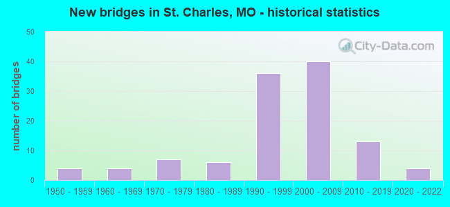
- New bridges - historical statistics
- 41950-1959
- 41960-1969
- 71970-1979
- 61980-1989
- 361990-1999
- 402000-2009
- 132010-2019
- 42020-2022
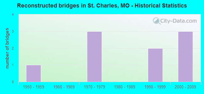
- Reconstructed bridges - Historical Statistics
- 11950-1959
- 01960-1969
- 31970-1979
- 01980-1989
- 21990-1999
- 32000-2009
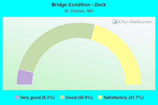
- Bridge Condition - Deck
- 8.3%Very good
- 50.0%Good
- 41.7%Satisfactory
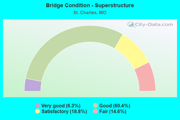
- Bridge Condition - Superstructure
- 6.3%Very good
- 60.4%Good
- 18.8%Satisfactory
- 14.6%Fair
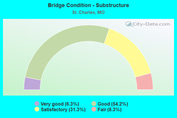
- Bridge Condition - Substructure
- 6.3%Very good
- 54.2%Good
- 31.3%Satisfactory
- 8.3%Fair
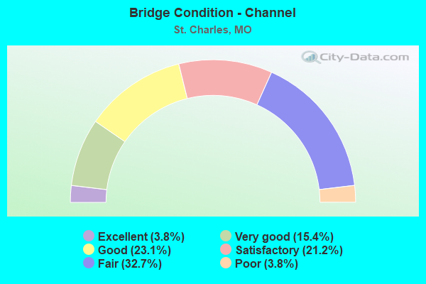
- Bridge Condition - Channel
- 3.8%Excellent
- 15.4%Very good
- 23.1%Good
- 21.2%Satisfactory
- 32.7%Fair
- 3.8%Poor
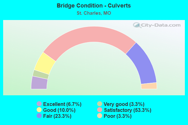
- Bridge Condition - Culverts
- 6.7%Excellent
- 3.3%Very good
- 10.0%Good
- 53.3%Satisfactory
- 23.3%Fair
- 3.3%Poor
Find on map >> Show street view
Structure Number: 12139, Location: S 1198 T 46 N R 4 E (Lat: 38.756747, Lng: -90.542689), Route carried "under" structure: State highway 94, Year Built: 2001, Structure Length: 0. m, Average Daily Traffic: 23,082 (year 2021), Truck Traffic: 4%, Features Intersected: MO 94
Minimum Vertical Clearance: 5.79m (19.00ft), Kilometerpoint: 174.081, Lanes on structure: 2, Lanes under structure: 2, Material/Design: Steel continuous, Design/Construction: Stringer/Multi-beam, Length of Maximum Span: 43.9m (144.0ft)
Find on map >> Show street view
Structure Number: 12139, Location: S 1198 T 46 N R 4 E (Lat: 38.756747, Lng: -90.542689), Route carried "under" structure: State highway 94, Year Built: 2001, Structure Length: 0. m, Average Daily Traffic: 21,275 (year 2021), Truck Traffic: 4%, Features Intersected: MO 94
Minimum Vertical Clearance: 5.56m (18.24ft), Kilometerpoint: 45.281, Lanes on structure: 2, Lanes under structure: 4, Material/Design: Steel continuous, Design/Construction: Stringer/Multi-beam, Length of Maximum Span: 43.9m (144.0ft)
Find on map >> Show street view
Structure Number: 1214, Location: S 1198 T 46 N R 4 E (Lat: 38.756786, Lng: -90.542581), Route carried "under" structure: State highway 94, Year Built: 2001, Structure Length: 0. m, Average Daily Traffic: 21,275 (year 2021), Truck Traffic: 4%, Features Intersected: MO 94, Facility Carried by Structure: RP MO364W TO MUEGG
Minimum Vertical Clearance: 5.66m (18.57ft), Kilometerpoint: 45.269, Lanes on structure: 3, Lanes under structure: 4, Material/Design: Steel continuous, Design/Construction: Stringer/Multi-beam, Length of Maximum Span: 43.9m (144.0ft)
Find on map >> Show street view
Structure Number: 1214, Location: S 1198 T 46 N R 4 E (Lat: 38.756786, Lng: -90.542581), Route carried "under" structure: State highway 94, Year Built: 2001, Structure Length: 0. m, Average Daily Traffic: 23,082 (year 2021), Truck Traffic: 4%, Features Intersected: MO 94, Facility Carried by Structure: RP MO364W TO MUEGG
Minimum Vertical Clearance: 5.97m (19.59ft), Kilometerpoint: 174.093, Lanes on structure: 3, Lanes under structure: 2, Material/Design: Steel continuous, Design/Construction: Stringer/Multi-beam, Length of Maximum Span: 43.9m (144.0ft)
Find on map >> Show street view
Structure Number: 2784, Location: S 3280 T 46 N R 5 E (Lat: 38.764711, Lng: -90.484606), Route carried "under" structure: City street , Year Built: 1978, Structure Length: 0. m, Average Daily Traffic: 6,104 (year 2021), Truck Traffic: 2%, Features Intersected: CST MAIN ST, Facility Carried by Structure: IS 70 E
Minimum Vertical Clearance: 10.64m (34.91ft), Kilometerpoint: 2.256, Lanes on structure: 5, Lanes under structure: 2, Material/Design: Steel continuous, Design/Construction: Truss - Thru, Length of Maximum Span: 146.3m (480.0ft)
Find on map >> Show street view
Structure Number: 2998, Location: S 3280 T 46 N R 5 E (Lat: 38.768531, Lng: -90.494517), Route carried "under" structure: Business State highway 70, Year Built: 1977, Structure Length: 0. m, Average Daily Traffic: 10,886 (year 2021), Truck Traffic: 5%, Features Intersected: LP 70
Minimum Vertical Clearance: 4.45m (14.60ft), Kilometerpoint: 4.357, Lanes on structure: 5, Lanes under structure: 2, Material/Design: Steel continuous, Design/Construction: Stringer/Multi-beam, Length of Maximum Span: 16.8m (55.1ft)
Find on map >> Show street view
Structure Number: 2999, Location: S 3280 T 46 N R 5 E (Lat: 38.768794, Lng: -90.494347), Route carried "under" structure: Business State highway 70, Year Built: 1977, Structure Length: 0. m, Average Daily Traffic: 14,173 (year 2021), Truck Traffic: 5%, Features Intersected: LP 70
Minimum Vertical Clearance: 4.46m (14.63ft), Kilometerpoint: 0.230, Lanes on structure: 5, Lanes under structure: 3, Material/Design: Steel continuous, Design/Construction: Stringer/Multi-beam, Length of Maximum Span: 16.8m (55.1ft)
Find on map >> Show street view
Structure Number: 30076, Location: S 3280 T 46 N R 5 E (Lat: 38.776792, Lng: -90.511769), Route carried "under" structure: Interstate 70, Year Built: 2006, Structure Length: 0. m, Average Daily Traffic: 65,441 (year 2021), Truck Traffic: 12%, Features Intersected: IS 70, Facility Carried by Structure: MO 94 E
Minimum Vertical Clearance: 5.10m (16.73ft), Kilometerpoint: 367.544, Lanes on structure: 8, Lanes under structure: 3, Material/Design: Steel continuous, Design/Construction: Stringer/Multi-beam, Length of Maximum Span: 26.0m (85.3ft)
Find on map >> Show street view
Structure Number: 30076, Location: S 3280 T 46 N R 5 E (Lat: 38.776792, Lng: -90.511769), Route carried "under" structure: Interstate 70, Year Built: 2006, Structure Length: 0. m, Average Daily Traffic: 64,209 (year 2021), Truck Traffic: 12%, Features Intersected: IS 70, Facility Carried by Structure: MO 94 E
Minimum Vertical Clearance: 5.10m (16.73ft), Kilometerpoint: 34.976, Lanes on structure: 8, Lanes under structure: 3, Material/Design: Steel continuous, Design/Construction: Stringer/Multi-beam, Length of Maximum Span: 26.0m (85.3ft)
Find on map >> Show street view
Structure Number: 31294, Location: S 3280 T 46 N R 5 E (Lat: 38.776314, Lng: -90.512936), Route carried "under" structure: ServiceState highway 70, Year Built: 2005, Structure Length: 0. m, Average Daily Traffic: 6,032 (year 2021), Truck Traffic: 2%, Features Intersected: OR 70, Facility Carried by Structure: MO 94 E
Minimum Vertical Clearance: 5.05m (16.57ft), Kilometerpoint: 9.249, Lanes on structure: 10, Lanes under structure: 3, Material/Design: Prestressed concrete, Design/Construction: Stringer/Multi-beam, Length of Maximum Span: 23.5m (77.1ft)
Find on map >> Show street view
Structure Number: 31335, Location: S 3280 T 46 N R 5 E (Lat: 38.777314, Lng: -90.510492), Route carried "under" structure: City street , Year Built: 2005, Structure Length: 0. m, Average Daily Traffic: 5,718 (year 2021), Truck Traffic: 4%, Features Intersected: CST BOONES LICK RD, Facility Carried by Structure: MO 94 E
Minimum Vertical Clearance: 5.08m (16.67ft), Kilometerpoint: 2.517, Lanes on structure: 10, Lanes under structure: 2, Material/Design: Prestressed concrete, Design/Construction: Stringer/Multi-beam, Length of Maximum Span: 18.9m (62.0ft)
Find on map >> Show street view
Structure Number: 31756, Location: S 3280 T 46 N R 4 E (Lat: 38.806597, Lng: -90.481700), Route carried "under" structure: State highway 370, Year Built: 2005, Structure Length: 0. m, Average Daily Traffic: 20,604 (year 2021), Truck Traffic: 5%, Features Intersected: MO 370, Facility Carried by Structure: MEL WETTER PKWY S
Minimum Vertical Clearance: 5.21m (17.09ft), Kilometerpoint: 12.014, Lanes on structure: 2, Lanes under structure: 3, Material/Design: Steel continuous, Design/Construction: Stringer/Multi-beam, Length of Maximum Span: 33.5m (109.9ft)
Find on map >> Show street view
Structure Number: 31756, Location: S 3280 T 46 N R 4 E (Lat: 38.806597, Lng: -90.481700), Route carried "under" structure: State highway 370, Year Built: 2005, Structure Length: 0. m, Average Daily Traffic: 21,413 (year 2021), Truck Traffic: 5%, Features Intersected: MO 370, Facility Carried by Structure: MEL WETTER PKWY S
Minimum Vertical Clearance: 5.21m (17.09ft), Kilometerpoint: 8.554, Lanes on structure: 2, Lanes under structure: 4, Material/Design: Steel continuous, Design/Construction: Stringer/Multi-beam, Length of Maximum Span: 33.5m (109.9ft)
Find on map >> Show street view
Structure Number: 3194, Location: S 3280 T 47 N R 4 E (Lat: 38.786678, Lng: -90.533022), Route carried "under" structure: Interstate 70, Year Built: 1981, Structure Length: 0. m, Average Daily Traffic: 54,683 (year 2021), Truck Traffic: 12%, Features Intersected: IS 70, Facility Carried by Structure: ZUMBEHL RD S
Minimum Vertical Clearance: 5.33m (17.49ft), Kilometerpoint: 365.381, Lanes on structure: 6, Lanes under structure: 3, Material/Design: Steel continuous, Design/Construction: Stringer/Multi-beam, Length of Maximum Span: 33.8m (110.9ft)
Find on map >> Show street view
Structure Number: 3194, Location: S 3280 T 47 N R 4 E (Lat: 38.786678, Lng: -90.533022), Route carried "under" structure: Interstate 70, Year Built: 1981, Structure Length: 0. m, Average Daily Traffic: 56,441 (year 2021), Truck Traffic: 12%, Features Intersected: IS 70, Facility Carried by Structure: ZUMBEHL RD S
Minimum Vertical Clearance: 5.11m (16.77ft), Kilometerpoint: 37.160, Lanes on structure: 6, Lanes under structure: 3, Material/Design: Steel continuous, Design/Construction: Stringer/Multi-beam, Length of Maximum Span: 33.8m (110.9ft)
Find on map >> Show street view
Structure Number: 35182, Location: S 3280 T 46 N R 5 E (Lat: 38.770939, Lng: -90.500358), Route carried "under" structure: Interstate 70, Year Built: 2016, Structure Length: 0. m, Average Daily Traffic: 65,441 (year 2021), Truck Traffic: 12%, Features Intersected: IS 70, Facility Carried by Structure: CONVENTION CENTER
Minimum Vertical Clearance: 5.06m (16.60ft), Kilometerpoint: 368.743, Lanes on structure: 4, Lanes under structure: 5, Material/Design: Prestressed concrete continuous, Design/Construction: Tee Beam, Length of Maximum Span: 26.7m (87.6ft)
Find on map >> Show street view
Structure Number: 35182, Location: S 3280 T 46 N R 5 E (Lat: 38.770939, Lng: -90.500358), Route carried "under" structure: Interstate 70, Year Built: 2016, Structure Length: 0. m, Average Daily Traffic: 64,209 (year 2021), Truck Traffic: 12%, Features Intersected: IS 70, Facility Carried by Structure: CONVENTION CENTER
Minimum Vertical Clearance: 5.05m (16.57ft), Kilometerpoint: 33.788, Lanes on structure: 4, Lanes under structure: 5, Material/Design: Prestressed concrete continuous, Design/Construction: Tee Beam, Length of Maximum Span: 26.7m (87.6ft)
Find on map >> Show street view
Structure Number: 3729, Location: S 32 T 47 N R 5 E (Lat: 38.798108, Lng: -90.466814), Route carried "under" structure: City street , Year Built: 1992, Structure Length: 0. m, Average Daily Traffic: 234 (year 2021), Truck Traffic: 4%, Features Intersected: CST MAIN ST, Facility Carried by Structure: MO 370 E
Minimum Vertical Clearance: 10.41m (34.15ft), Kilometerpoint: 1.286, Lanes on structure: 3, Lanes under structure: 2, Material/Design: Steel, Design/Construction: Truss - Thru, Length of Maximum Span: 190.5m (625.0ft)
Find on map >> Show street view
Structure Number: 373, Location: S 32 T 47 N R 5 E (Lat: 38.798203, Lng: -90.466647), Route carried "under" structure: City street , Year Built: 1993, Structure Length: 0. m, Average Daily Traffic: 234 (year 2021), Truck Traffic: 4%, Features Intersected: CST MAIN ST, Facility Carried by Structure: MO 370 W
Minimum Vertical Clearance: 10.41m (34.15ft), Kilometerpoint: 1.263, Lanes on structure: 3, Lanes under structure: 5, Material/Design: Steel, Design/Construction: Truss - Thru, Length of Maximum Span: 190.5m (625.0ft)
Find on map >> Show street view
Structure Number: 4043, Location: S 161 T 47 N R 5 E (Lat: 38.803119, Lng: -90.475350), Route carried "under" structure: State highway 94, Year Built: 1991, Structure Length: 0. m, Average Daily Traffic: 10,417 (year 2021), Truck Traffic: 6%, Features Intersected: MO 94, Facility Carried by Structure: MO 370 E
Minimum Vertical Clearance: 5.16m (16.93ft), Kilometerpoint: 183.441, Lanes on structure: 3, Lanes under structure: 5, Material/Design: Steel continuous, Design/Construction: Stringer/Multi-beam, Length of Maximum Span: 36.3m (119.1ft)
Find on map >> Show street view
Structure Number: 4113, Location: S 161 T 47 N R 5 E (Lat: 38.803336, Lng: -90.475300), Route carried "under" structure: State highway 94, Year Built: 1991, Structure Length: 0. m, Average Daily Traffic: 10,417 (year 2021), Truck Traffic: 6%, Features Intersected: MO 94, Facility Carried by Structure: MO 370 W
Minimum Vertical Clearance: 5.11m (16.77ft), Kilometerpoint: 183.464, Lanes on structure: 5, Lanes under structure: 5, Material/Design: Steel continuous, Design/Construction: Stringer/Multi-beam, Length of Maximum Span: 36.3m (119.1ft)
Find on map >> Show street view
Structure Number: 4202, Location: S 13 T 47 N R 4 E (Lat: 38.824178, Lng: -90.518094), Route carried "under" structure: City street , Year Built: 1994, Structure Length: 0. m, Average Daily Traffic: 13,339 (year 2021), Truck Traffic: 5%, Features Intersected: CST ELM ST, Facility Carried by Structure: MO 370 E
Minimum Vertical Clearance: 5.05m (16.57ft), Kilometerpoint: 0.113, Lanes on structure: 3, Lanes under structure: 6, Material/Design: Steel continuous, Design/Construction: Stringer/Multi-beam, Length of Maximum Span: 35.7m (117.1ft)
Find on map >> Show street view
Structure Number: 4203, Location: S 27 T 47 N R 5 E (Lat: 38.820986, Lng: -90.506639), Route carried "under" structure: County highway , Year Built: 1994, Structure Length: 0. m, Average Daily Traffic: 9,106 (year 2021), Truck Traffic: 5%, Features Intersected: CRD ELM POINT IND DR, Facility Carried by Structure: MO 370 E
Minimum Vertical Clearance: 4.93m (16.17ft), Kilometerpoint: 2.303, Lanes on structure: 3, Lanes under structure: 2, Material/Design: Prestressed concrete continuous, Design/Construction: Stringer/Multi-beam, Length of Maximum Span: 19.2m (63.0ft)
Find on map >> Show street view
Structure Number: 4213, Location: S 13 T 47 N R 4 E (Lat: 38.824353, Lng: -90.518100), Route carried "under" structure: City street , Year Built: 1994, Structure Length: 0. m, Average Daily Traffic: 9,800 (year 2021), Truck Traffic: 5%, Features Intersected: CST ELM ST, Facility Carried by Structure: MO 370 W
Minimum Vertical Clearance: 5.28m (17.32ft), Kilometerpoint: 0.093, Lanes on structure: 3, Lanes under structure: 6, Material/Design: Steel continuous, Design/Construction: Stringer/Multi-beam, Length of Maximum Span: 35.7m (117.1ft)
Find on map >> Show street view
Structure Number: 4214, Location: S 27 T 47 N R 5 E (Lat: 38.821103, Lng: -90.506517), Route carried "under" structure: County highway , Year Built: 1994, Structure Length: 0. m, Average Daily Traffic: 9,106 (year 2021), Truck Traffic: 5%, Features Intersected: CRD ELM POINT IND DR, Facility Carried by Structure: MO 370 W
Minimum Vertical Clearance: 4.93m (16.17ft), Kilometerpoint: 2.321, Lanes on structure: 3, Lanes under structure: 2, Material/Design: Prestressed concrete continuous, Design/Construction: Stringer/Multi-beam, Length of Maximum Span: 19.2m (63.0ft)
Find on map >> Show street view
Structure Number: 6672, Location: S 32 T 47 N R 5 E (Lat: 38.764858, Lng: -90.484025), Route carried "under" structure: City street , Year Built: 1958, Structure Length: 0. m, Average Daily Traffic: 6,104 (year 2021), Truck Traffic: 2%, Features Intersected: CST MAIN ST, Facility Carried by Structure: IS 70 W
Minimum Vertical Clearance: 10.44m (34.25ft), Kilometerpoint: 2.221, Lanes on structure: 5, Lanes under structure: 2, Material/Design: Steel continuous, Design/Construction: Truss - Thru, Length of Maximum Span: 146.3m (480.0ft)