Bridge Statistics for St. Joseph, Missouri (MO)
Condition, Traffic, Stress, Structural Evaluation, Project Costs
- National Bridge Inventory (NBI) Statistics
- 251Number of bridges
- 5,059ft / 1,542mTotal length
- $101,086,000Total costs
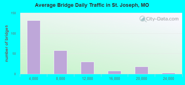
- 1,461,760Total average daily traffic
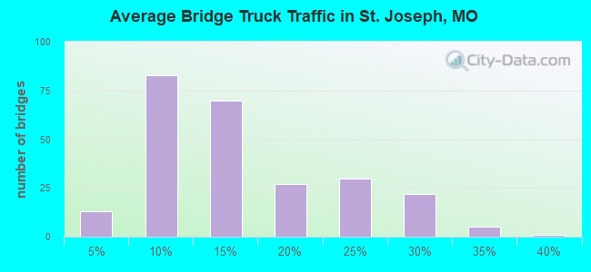
- 229,337Total average daily truck traffic
- National Bridge Inventory (NBI) Registered Bridges for St. Joseph
- No street view available for this location
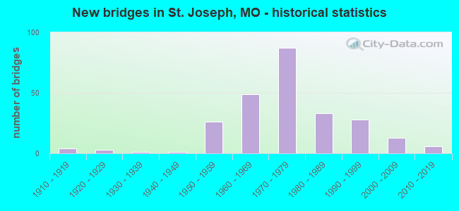
- New bridges - historical statistics
- 41910-1919
- 31920-1929
- 11930-1939
- 11940-1949
- 261950-1959
- 491960-1969
- 871970-1979
- 331980-1989
- 281990-1999
- 132000-2009
- 62010-2019
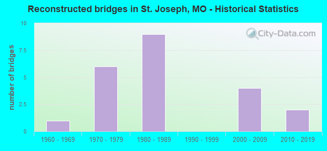
- Reconstructed bridges - Historical Statistics
- 11960-1969
- 61970-1979
- 91980-1989
- 01990-1999
- 42000-2009
- 22010-2019
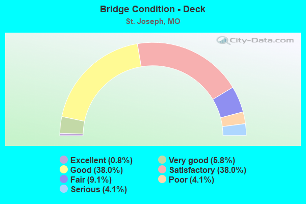
- Bridge Condition - Deck
- 0.8%Excellent
- 5.8%Very good
- 38.0%Good
- 38.0%Satisfactory
- 9.1%Fair
- 4.1%Poor
- 4.1%Serious
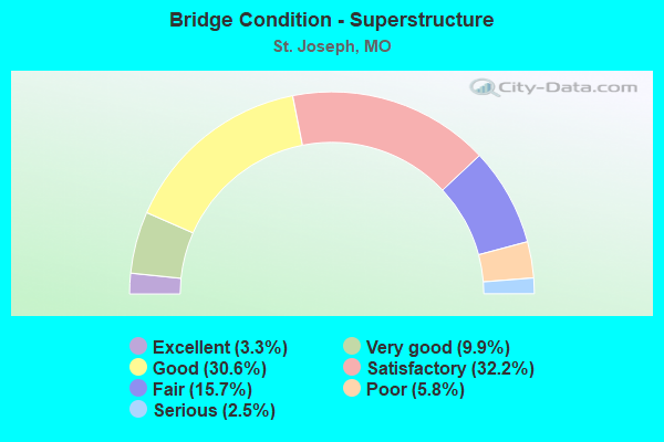
- Bridge Condition - Superstructure
- 3.3%Excellent
- 9.9%Very good
- 30.6%Good
- 32.2%Satisfactory
- 15.7%Fair
- 5.8%Poor
- 2.5%Serious
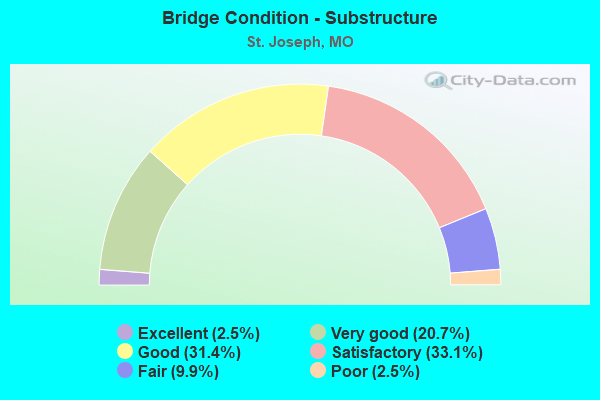
- Bridge Condition - Substructure
- 2.5%Excellent
- 20.7%Very good
- 31.4%Good
- 33.1%Satisfactory
- 9.9%Fair
- 2.5%Poor
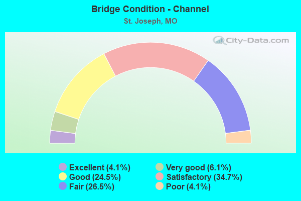
- Bridge Condition - Channel
- 4.1%Excellent
- 6.1%Very good
- 24.5%Good
- 34.7%Satisfactory
- 26.5%Fair
- 4.1%Poor
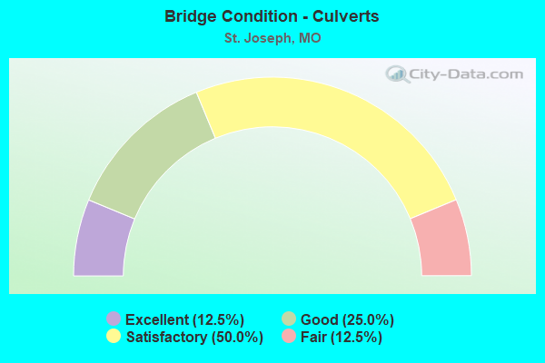
- Bridge Condition - Culverts
- 12.5%Excellent
- 25.0%Good
- 50.0%Satisfactory
- 12.5%Fair
Find on map >> Show street view
Structure Number: 515, Location: S 22 T 57 N R 35 W (Lat: 39.747747, Lng: -94.817389), Route carried "on" structure: US 36, Year Built: 1961, Year Reconstructed: 1987, Status: Posted for load, Structure Length: 5.09m (16.70ft), Average Daily Traffic: 11,331 (year 2021), Truck Traffic: 8%, Average Future Daily Traffic: 19,263 (year 2041), Design Load: HS 20, Features Intersected: CST SOUTHWEST PKWY
Minimum Vertical Clearance: 30+ m (98+ ft), Kilometerpoint: 306.309, Lanes on structure: 2, Lanes under structure: 2, Base Highway Network: Yes, Owner: State Highway Agency, Approaching Roadway Width: 8.5m (27.9ft), Skew: 20 degrees, Material/Design: Concrete continuous, Design/Construction: Slab, Number Of Spans In Main Unit: 3, Length of Maximum Span: 18.3m (60.0ft), Curb or Sidewalk Widths: Left: 0.2m (0.7ft), Right: 0.2m (0.7ft), Curb-To-Curb Width: 9.1m (29.9ft), Out-to-Out Width: 10.0m (32.8ft)
Condition: Deck: Fair, Superstructure: Fair, Substructure: Satisfactory, Operating Rating: 55.8 metric tons, Method Used To Determine Operating Rating: Load Factor (LF), Inventory Rating: 33.3 metric tons, Method Used To Determine Inventory Rating: Load Factor (LF), Structural Evaluation: Somewhat better than minimum adequacy, Deck Geometry: High priority of replacement, Underclear: Equal to present desirable criteria, Approach Roadway Alignment: Equal to present desirable criteria, Length Of Structure Improvement: 0.61m (2.00ft), Designated Inspection Frequency: Every 24 months, Inspection Date: August 2020, Bridge Improvement Cost: $498,000, Roadway Improvement Cost: $50,000, Total Project Cost: $747,000 ( Estimate for 2022), Deck Structure Type: Concrete Cast-file-Place, Wearing Surface/Protective System: Wearing Surface: Bituminous, Membrane: Built-up, Deck Protection: Cathodic Protection
Find on map >> Show street view
Structure Number: 563, Location: S 21 T 57 N R 34 W (Lat: 39.748053, Lng: -94.726353), Route carried "on" structure: US 36, Year Built: 1962, Year Reconstructed: 2014, Status: Posted for load, Structure Length: 37.16m (121.92ft), Average Daily Traffic: 7,174 (year 2021), Truck Traffic: 20%, Average Future Daily Traffic: 12,196 (year 2041), Design Load: HS 20, Features Intersected: PLATTE RVR
Minimum Vertical Clearance: 30+ m (98+ ft), Kilometerpoint: 298.180, Lanes on structure: 2, Base Highway Network: Yes, Owner: State Highway Agency, Approaching Roadway Width: 11.0m (36.1ft), Skew: 13 degrees, Material/Design: Steel continuous, Design/Construction: Stringer/Multi-beam, Number Of Spans In Main Unit: 3, Number Of Approach Spans: 14, Length of Maximum Span: 45.7m (149.9ft), Curb-To-Curb Width: 9.1m (29.9ft), Out-to-Out Width: 10.0m (32.8ft)
Condition: Deck: Very good, Superstructure: Excellent, Substructure: Very good, Channel: Satisfactory, Operating Rating: 46.8 metric tons, Method Used To Determine Operating Rating: Load Factor (LF), Inventory Rating: 27.9 metric tons, Method Used To Determine Inventory Rating: Load Factor (LF), Structural Evaluation: Better than present minimum criteria, Deck Geometry: Meets minimum limits, Waterway Adequacy: Equal to present desirable criteria, Approach Roadway Alignment: Equal to present desirable criteria, Designated Inspection Frequency: Every 24 months, Inspection Date: August 2020, Deck Structure Type: Concrete Cast-file-Place, Wearing Surface/Protective System: Wearing Surface: Monolithic Concrete, Deck Protection: Internally Sealed
Find on map >> Show street view
Structure Number: 6, Location: S 26 T 57 N R 35 W (Lat: 39.724214, Lng: -94.788422), Route carried "on" structure: Interstate 29, Year Built: 1958, Year Reconstructed: 1988, Status: Open, Structure Length: 4.79m (15.72ft), Average Daily Traffic: 16,155 (year 2021), Truck Traffic: 19%, Average Future Daily Traffic: 27,464 (year 2041), Design Load: HS 20+Mod, Features Intersected: US 169
Minimum Vertical Clearance: 30+ m (98+ ft), Kilometerpoint: 78.747, Lanes on structure: 2, Lanes under structure: 4, Base Highway Network: Yes, Owner: State Highway Agency, Approaching Roadway Width: 12.8m (42.0ft), Material/Design: Steel continuous, Design/Construction: Stringer/Multi-beam, Number Of Spans In Main Unit: 3, Length of Maximum Span: 17.4m (57.1ft), Curb or Sidewalk Widths: Left: 0.2m (0.7ft), Right: 0.2m (0.7ft), Curb-To-Curb Width: 11.6m (38.1ft), Out-to-Out Width: 12.4m (40.7ft)
Condition: Deck: Satisfactory, Superstructure: Good, Substructure: Good, Operating Rating: 76.5 metric tons, Method Used To Determine Operating Rating: Load Factor (LF), Inventory Rating: 45.9 metric tons, Method Used To Determine Inventory Rating: Load Factor (LF), Structural Evaluation: Better than present minimum criteria, Deck Geometry: Equal to present minimum criteria, Approach Roadway Alignment: Equal to present desirable criteria, Designated Inspection Frequency: Every 24 months, Inspection Date: August 2020, Deck Structure Type: Concrete Cast-file-Place, Wearing Surface/Protective System: Wearing Surface: Monolithic Concrete, Deck Protection: Epoxy Coated Reinforcing
Find on map >> Show street view
Structure Number: 6203, Location: S 20 T 57 N R 35 W (Lat: 39.749100, Lng: -94.849333), Route carried "on" structure: US 36, Year Built: 1961, Year Reconstructed: 1979, Status: Posted for load, Structure Length: 4.75m (15.58ft), Average Daily Traffic: 21,827 (year 2021), Truck Traffic: 11%, Average Future Daily Traffic: 37,106 (year 2041), Design Load: HS 20, Features Intersected: LP 29
Minimum Vertical Clearance: 30+ m (98+ ft), Kilometerpoint: 0.895, Lanes on structure: 4, Lanes under structure: 2, Base Highway Network: Yes, Owner: State Highway Agency, Approaching Roadway Width: 27.4m (89.9ft), Skew: 20 degrees, Material/Design: Concrete continuous, Design/Construction: Slab, Number Of Spans In Main Unit: 3, Length of Maximum Span: 19.2m (63.0ft), Curb or Sidewalk Widths: Left: 0.2m (0.7ft), Right: 0.2m (0.7ft), Curb-To-Curb Width: 22.5m (73.8ft), Out-to-Out Width: 26.9m (88.3ft)
Condition: Deck: Fair, Superstructure: Fair, Substructure: Good, Operating Rating: 44.1 metric tons, Method Used To Determine Operating Rating: Load Factor (LF), Inventory Rating: 26.1 metric tons, Method Used To Determine Inventory Rating: Load Factor (LF), Structural Evaluation: Somewhat better than minimum adequacy, Deck Geometry: Superior to present desirable criteria, Underclear: High priority of corrective action, Approach Roadway Alignment: Equal to present desirable criteria, Length Of Structure Improvement: 0.58m (1.90ft), Designated Inspection Frequency: Every 24 months, Inspection Date: July 2020, Bridge Improvement Cost: $946,000, Roadway Improvement Cost: $95,000, Total Project Cost: $1,419,000 ( Estimate for 2022), Deck Structure Type: Concrete Cast-file-Place, Wearing Surface/Protective System: Wearing Surface: Bituminous, Membrane: Built-up
Find on map >> Show street view
Structure Number: 679, Location: S 21 T 57 N R 34 W (Lat: 39.747831, Lng: -94.726253), Route carried "on" structure: US 36, Year Built: 1978, Status: Posted for load, Structure Length: 36.09m (118.41ft), Average Daily Traffic: 7,665 (year 2021), Truck Traffic: 25%, Average Future Daily Traffic: 13,031 (year 2041), Design Load: HS 20, Features Intersected: PLATTE RVR
Minimum Vertical Clearance: 30+ m (98+ ft), Kilometerpoint: 11.573, Lanes on structure: 2, Base Highway Network: Yes, Owner: State Highway Agency, Approaching Roadway Width: 12.2m (40.0ft), Skew: 13 degrees, Material/Design: Steel continuous, Design/Construction: Stringer/Multi-beam, Number Of Spans In Main Unit: 3, Number Of Approach Spans: 13, Length of Maximum Span: 45.7m (149.9ft), Curb-To-Curb Width: 12.0m (39.4ft), Out-to-Out Width: 12.9m (42.3ft)
Condition: Deck: Good, Superstructure: Good, Substructure: Good, Channel: Fair, Operating Rating: 50.4 metric tons, Method Used To Determine Operating Rating: Load Factor (LF), Inventory Rating: 29.7 metric tons, Method Used To Determine Inventory Rating: Load Factor (LF), Structural Evaluation: Better than present minimum criteria, Deck Geometry: Better than present minimum criteria, Waterway Adequacy: Equal to present desirable criteria, Approach Roadway Alignment: Equal to present desirable criteria, Designated Inspection Frequency: Every 24 months, Inspection Date: August 2020, Deck Structure Type: Concrete Cast-file-Place, Wearing Surface/Protective System: Wearing Surface: Monolithic Concrete, Deck Protection: Internally Sealed
Find on map >> Show street view
Structure Number: 68, Location: S 21 T 57 N R 34 W (Lat: 39.747783, Lng: -94.721361), Route carried "on" structure: US 36, Year Built: 1962, Year Reconstructed: 2010, Status: Open, Structure Length: 0.76m (2.49ft), Average Daily Traffic: 14,839 (year 2021), Truck Traffic: 25%, Average Future Daily Traffic: 25,226 (year 2041), Design Load: HS 20, Features Intersected: PLATE RVR CHNL
Minimum Vertical Clearance: 30+ m (98+ ft), Kilometerpoint: 12.162, Lanes on structure: 4, Base Highway Network: Yes, Owner: State Highway Agency, Approaching Roadway Width: 25.3m (83.0ft), Material/Design: Concrete continuous, Design/Construction: Culvert, Number Of Spans In Main Unit: 3, Length of Maximum Span: 2.4m (7.9ft), Curb-To-Curb Width: 25.3m (83.0ft), Out-to-Out Width: 25.9m (85.0ft)
Condition: Channel: Fair, Culverts: Satisfactory, Operating Rating: 72.0 metric tons, Method Used To Determine Operating Rating: Field evaluation and documented engineering judgment, Inventory Rating: 43.2 metric tons, Method Used To Determine Inventory Rating: Field evaluation and documented engineering judgment, Structural Evaluation: Equal to present minimum criteria, Deck Geometry: Superior to present desirable criteria, Waterway Adequacy: Equal to present minimum criteria, Approach Roadway Alignment: Equal to present desirable criteria, Designated Inspection Frequency: Every 24 months, Inspection Date: November 2020
Find on map >> Show street view
Structure Number: 789, Location: S 26 T 58 N R 35 W (Lat: 39.815100, Lng: -94.803553), Route carried "on" structure: US 169, Year Built: 1962, Year Reconstructed: 2009, Status: Posted for load, Structure Length: 9.17m (30.09ft), Average Daily Traffic: 11,187 (year 2021), Truck Traffic: 14%, Average Future Daily Traffic: 15,102 (year 2041), Design Load: HS 20, Features Intersected: IS 29
Minimum Vertical Clearance: 30+ m (98+ ft), Kilometerpoint: 111.317, Lanes on structure: 4, Lanes under structure: 4, Base Highway Network: Yes, Owner: State Highway Agency, Approaching Roadway Width: 18.3m (60.0ft), Skew: 3 degrees, Material/Design: Steel continuous, Design/Construction: Stringer/Multi-beam, Number Of Spans In Main Unit: 4, Length of Maximum Span: 25.6m (84.0ft), Curb-To-Curb Width: 15.8m (51.8ft), Out-to-Out Width: 18.4m (60.4ft)
Condition: Deck: Good, Superstructure: Good, Substructure: Satisfactory, Operating Rating: 54.9 metric tons, Method Used To Determine Operating Rating: Load Factor (LF), Inventory Rating: 33.3 metric tons, Method Used To Determine Inventory Rating: Load Factor (LF), Structural Evaluation: Equal to present minimum criteria, Deck Geometry: Meets minimum limits, Underclear: Somewhat better than minimum adequacy, Approach Roadway Alignment: Equal to present desirable criteria, Designated Inspection Frequency: Every 24 months, Inspection Date: August 2020, Deck Structure Type: Concrete Cast-file-Place, Wearing Surface/Protective System: Wearing Surface: Monolithic Concrete, Deck Protection: Epoxy Coated Reinforcing
Find on map >> Show street view
Structure Number: 952, Location: S 18 T 58 N R 35 W (Lat: 39.835425, Lng: -94.865006), Route carried "on" structure: State highway K, Year Built: 1983, Status: Posted for load, Structure Length: 10.76m (35.30ft), Average Daily Traffic: 2,407 (year 2021), Truck Traffic: 5%, Average Future Daily Traffic: 3,249 (year 2041), Design Load: H 20, Features Intersected: IS 229
Minimum Vertical Clearance: 30+ m (98+ ft), Kilometerpoint: 10.631, Lanes on structure: 2, Lanes under structure: 4, Base Highway Network: Yes, Owner: State Highway Agency, Approaching Roadway Width: 12.2m (40.0ft), Skew: 4 degrees, Material/Design: Steel continuous, Design/Construction: Stringer/Multi-beam, Number Of Spans In Main Unit: 2, Number Of Approach Spans: 2, Length of Maximum Span: 37.5m (123.0ft), Curb or Sidewalk Widths: Left: 0.2m (0.7ft), Right: 0.2m (0.7ft), Curb-To-Curb Width: 13.4m (44.0ft), Out-to-Out Width: 14.2m (46.6ft)
Condition: Deck: Satisfactory, Superstructure: Good, Substructure: Satisfactory, Operating Rating: 46.8 metric tons, Method Used To Determine Operating Rating: Load Factor (LF), Inventory Rating: 27.9 metric tons, Method Used To Determine Inventory Rating: Load Factor (LF), Structural Evaluation: Equal to present minimum criteria, Deck Geometry: Better than present minimum criteria, Underclear: Somewhat better than minimum adequacy, Approach Roadway Alignment: Equal to present desirable criteria, Designated Inspection Frequency: Every 24 months, Other Special Inspection Frequency: Every 24 months, Inspection Date: Febuary 2021, Other Special Inspection Date: Febuary 2021, Deck Structure Type: Concrete Cast-file-Place, Wearing Surface/Protective System: Wearing Surface: Monolithic Concrete, Deck Protection: Internally Sealed
Find on map >> Show street view
Structure Number: 953, Location: S 30 T 57 N R 35 W (Lat: 39.806883, Lng: -94.866042), Route carried "on" structure: City street , Year Built: 1983, Status: Posted for load, Structure Length: 8.20m (26.90ft), Average Daily Traffic: 46 (year 2021), Truck Traffic: 4%, Average Future Daily Traffic: 60 (year 2041), Design Load: HS 15, Features Intersected: IS 229, Facility Carried by Structure: COOK RD E
Minimum Vertical Clearance: 30+ m (98+ ft), Kilometerpoint: 0.056, Lanes on structure: 2, Lanes under structure: 4, Owner: State Highway Agency, Approaching Roadway Width: 6.1m (20.0ft), Skew: 1 degrees, Material/Design: Steel continuous, Design/Construction: Stringer/Multi-beam, Number Of Spans In Main Unit: 2, Length of Maximum Span: 34.7m (113.8ft), Curb-To-Curb Width: 8.5m (27.9ft), Out-to-Out Width: 9.4m (30.8ft)
Condition: Deck: Good, Superstructure: Satisfactory, Substructure: Satisfactory, Operating Rating: 29.7 metric tons, Method Used To Determine Operating Rating: Allowable Stress (AS), Inventory Rating: 18.0 metric tons, Method Used To Determine Inventory Rating: Allowable Stress (AS), Structural Evaluation: Somewhat better than minimum adequacy, Deck Geometry: Better than present minimum criteria, Underclear: Equal to present minimum criteria, Approach Roadway Alignment: Equal to present desirable criteria, Designated Inspection Frequency: Every 24 months, Inspection Date: August 2020, Deck Structure Type: Concrete Cast-file-Place, Wearing Surface/Protective System: Wearing Surface: Monolithic Concrete, Deck Protection: Internally Sealed
Find on map >> Show street view
Structure Number: 954, Location: S 31 T 57 N R 35 W (Lat: 39.800794, Lng: -94.868572), Route carried "on" structure: City street , Year Built: 1983, Status: Posted for load, Structure Length: 8.53m (27.99ft), Average Daily Traffic: 124 (year 2021), Truck Traffic: 5%, Average Future Daily Traffic: 161 (year 2041), Design Load: HS 15, Features Intersected: IS 229, Facility Carried by Structure: HUNTOON RD S
Minimum Vertical Clearance: 30+ m (98+ ft), Kilometerpoint: 1.543, Lanes on structure: 2, Lanes under structure: 4, Owner: State Highway Agency, Approaching Roadway Width: 6.1m (20.0ft), Skew: 2 degrees, Material/Design: Steel continuous, Design/Construction: Stringer/Multi-beam, Number Of Spans In Main Unit: 2, Length of Maximum Span: 34.7m (113.8ft), Curb-To-Curb Width: 8.5m (27.9ft), Out-to-Out Width: 9.0m (29.5ft)
Condition: Deck: Satisfactory, Superstructure: Satisfactory, Substructure: Satisfactory, Operating Rating: 29.7 metric tons, Method Used To Determine Operating Rating: Allowable Stress (AS), Inventory Rating: 18.0 metric tons, Method Used To Determine Inventory Rating: Allowable Stress (AS), Structural Evaluation: Somewhat better than minimum adequacy, Deck Geometry: Equal to present minimum criteria, Underclear: Equal to present minimum criteria, Approach Roadway Alignment: Equal to present minimum criteria, Designated Inspection Frequency: Every 24 months, Inspection Date: August 2020, Deck Structure Type: Concrete Cast-file-Place, Wearing Surface/Protective System: Wearing Surface: Monolithic Concrete, Deck Protection: Epoxy Coated Reinforcing
Find on map >> Show street view
Structure Number: 955, Location: S 35 T 57 N R 35 W (Lat: 39.709994, Lng: -94.796206), Route carried "on" structure: State highway A, Year Built: 1965, Status: Posted for load, Structure Length: 6.61m (21.69ft), Average Daily Traffic: 4,589 (year 2021), Truck Traffic: 6%, Average Future Daily Traffic: 6,195 (year 2041), Design Load: H 20, Features Intersected: IS 229
Minimum Vertical Clearance: 30+ m (98+ ft), Kilometerpoint: 1.736, Lanes on structure: 2, Lanes under structure: 4, Owner: State Highway Agency, Approaching Roadway Width: 7.3m (24.0ft), Skew: 2 degrees, Material/Design: Concrete continuous, Design/Construction: Slab, Number Of Spans In Main Unit: 4, Length of Maximum Span: 18.3m (60.0ft), Curb-To-Curb Width: 9.1m (29.9ft), Out-to-Out Width: 9.9m (32.5ft)
Condition: Deck: Fair, Superstructure: Fair, Substructure: Satisfactory, Operating Rating: 40.5 metric tons, Method Used To Determine Operating Rating: Allowable Stress (AS), Inventory Rating: 27.9 metric tons, Method Used To Determine Inventory Rating: Allowable Stress (AS), Structural Evaluation: Somewhat better than minimum adequacy, Deck Geometry: Meets minimum limits, Underclear: Meets minimum limits, Approach Roadway Alignment: Equal to present desirable criteria, Designated Inspection Frequency: Every 24 months, Inspection Date: August 2020, Deck Structure Type: Concrete Cast-file-Place, Wearing Surface/Protective System: Wearing Surface: Monolithic Concrete
Find on map >> Show street view
Structure Number: 969, Location: S 19 T 58 N R 35 W (Lat: 39.823294, Lng: -94.866550), Route carried "on" structure: Interstate 229, Year Built: 1983, Status: Open, Structure Length: 5.97m (19.59ft), Average Daily Traffic: 3,068 (year 2021), Truck Traffic: 25%, Average Future Daily Traffic: 6,443 (year 2041), Design Load: HS 20+Mod, Features Intersected: CRD 385
Minimum Vertical Clearance: 30+ m (98+ ft), Kilometerpoint: 7.395, Lanes on structure: 2, Lanes under structure: 2, Base Highway Network: Yes, Owner: State Highway Agency, Approaching Roadway Width: 12.2m (40.0ft), Skew: 4 degrees, Material/Design: Prestressed concrete continuous, Design/Construction: Stringer/Multi-beam, Number Of Spans In Main Unit: 3, Length of Maximum Span: 20.9m (68.6ft), Curb or Sidewalk Widths: Left: 0.2m (0.7ft), Right: 0.2m (0.7ft), Curb-To-Curb Width: 12.0m (39.4ft), Out-to-Out Width: 12.8m (42.0ft)
Condition: Deck: Good, Superstructure: Good, Substructure: Good, Operating Rating: 78.3 metric tons, Method Used To Determine Operating Rating: Load Factor (LF), Inventory Rating: 36.0 metric tons, Method Used To Determine Inventory Rating: Load Factor (LF), Structural Evaluation: Better than present minimum criteria, Deck Geometry: Equal to present minimum criteria, Underclear: Somewhat better than minimum adequacy, Approach Roadway Alignment: Equal to present desirable criteria, Designated Inspection Frequency: Every 24 months, Inspection Date: September 2020, Deck Structure Type: Concrete Cast-file-Place, Wearing Surface/Protective System: Wearing Surface: Monolithic Concrete, Deck Protection: Epoxy Coated Reinforcing
Find on map >> Show street view
Structure Number: 1, Location: S 2 T 57 N R 35 W (Lat: 39.777008, Lng: -94.793636), Route carried "under" structure: Interstate 29, Year Built: 1958, Structure Length: 0. m, Average Daily Traffic: 19,688 (year 2021), Truck Traffic: 28%, Features Intersected: IS 29, Facility Carried by Structure: MO 6 E
Minimum Vertical Clearance: 4.83m (15.85ft), Kilometerpoint: 84.661, Lanes on structure: 6, Lanes under structure: 2, Material/Design: Steel continuous, Design/Construction: Stringer/Multi-beam, Length of Maximum Span: 17.1m (56.1ft)
Find on map >> Show street view
Structure Number: 1, Location: S 2 T 57 N R 35 W (Lat: 39.777008, Lng: -94.793636), Route carried "under" structure: Interstate 29, Year Built: 1958, Structure Length: 0. m, Average Daily Traffic: 18,030 (year 2021), Truck Traffic: 30%, Features Intersected: IS 29, Facility Carried by Structure: MO 6 E
Minimum Vertical Clearance: 4.85m (15.91ft), Kilometerpoint: 122.526, Lanes on structure: 6, Lanes under structure: 2, Material/Design: Steel continuous, Design/Construction: Stringer/Multi-beam, Length of Maximum Span: 17.1m (56.1ft)
Find on map >> Show street view
Structure Number: 1018, Location: S 34 T 57 N R 35 W (Lat: 39.715081, Lng: -94.814089), Route carried "under" structure: City street , Year Built: 1965, Structure Length: 0. m, Average Daily Traffic: 716 (year 2021), Truck Traffic: 19%, Features Intersected: CST AJAX RD, Facility Carried by Structure: IS 229 N
Minimum Vertical Clearance: 6.58m (21.59ft), Kilometerpoint: 2.840, Lanes on structure: 2, Lanes under structure: 2, Material/Design: Steel continuous, Design/Construction: Stringer/Multi-beam, Length of Maximum Span: 22.9m (75.1ft)
Find on map >> Show street view
Structure Number: 1019, Location: S 34 T 57 N R 35 W (Lat: 39.714878, Lng: -94.814142), Route carried "under" structure: City street , Year Built: 1965, Structure Length: 0. m, Average Daily Traffic: 716 (year 2021), Truck Traffic: 19%, Features Intersected: CST AJAX RD, Facility Carried by Structure: IS 229 S
Minimum Vertical Clearance: 6.53m (21.42ft), Kilometerpoint: 2.863, Lanes on structure: 2, Lanes under structure: 2, Material/Design: Steel continuous, Design/Construction: Stringer/Multi-beam, Length of Maximum Span: 22.9m (75.1ft)
Find on map >> Show street view
Structure Number: 12127, Location: S 11 T 57 N R 35 W (Lat: 39.769686, Lng: -94.792564), Route carried "under" structure: Interstate 29, Year Built: 2001, Structure Length: 0. m, Average Daily Traffic: 19,203 (year 2021), Truck Traffic: 18%, Features Intersected: IS 29, Facility Carried by Structure: FARAON ST E
Minimum Vertical Clearance: 5.13m (16.83ft), Kilometerpoint: 123.342, Lanes on structure: 3, Lanes under structure: 2, Material/Design: Steel continuous, Design/Construction: Stringer/Multi-beam, Length of Maximum Span: 35.1m (115.2ft)
Find on map >> Show street view
Structure Number: 12127, Location: S 11 T 57 N R 35 W (Lat: 39.769686, Lng: -94.792564), Route carried "under" structure: Interstate 29, Year Built: 2001, Structure Length: 0. m, Average Daily Traffic: 19,688 (year 2021), Truck Traffic: 28%, Features Intersected: IS 29, Facility Carried by Structure: FARAON ST E
Minimum Vertical Clearance: 5.13m (16.83ft), Kilometerpoint: 83.841, Lanes on structure: 3, Lanes under structure: 2, Material/Design: Steel continuous, Design/Construction: Stringer/Multi-beam, Length of Maximum Span: 35.1m (115.2ft)
Find on map >> Show street view
Structure Number: 1234, Location: S 28 T 57 N R 35 W (Lat: 39.721611, Lng: -94.833772), Route carried "under" structure: City street , Year Built: 1979, Structure Length: 0. m, Average Daily Traffic: 5,260 (year 2021), Truck Traffic: 9%, Features Intersected: CST 22ND ST, Facility Carried by Structure: IS 229 S
Minimum Vertical Clearance: 4.52m (14.83ft), Kilometerpoint: 7.807, Lanes on structure: 2, Lanes under structure: 2, Material/Design: Steel continuous, Design/Construction: Stringer/Multi-beam, Length of Maximum Span: 27.6m (90.6ft)
Find on map >> Show street view
Structure Number: 1235, Location: S 28 T 57 N R 35 W (Lat: 39.721806, Lng: -94.833694), Route carried "under" structure: City street , Year Built: 1979, Structure Length: 0. m, Average Daily Traffic: 5,715 (year 2021), Truck Traffic: 7%, Features Intersected: CST 22ND ST, Facility Carried by Structure: IS 229 N
Minimum Vertical Clearance: 4.60m (15.09ft), Kilometerpoint: 7.781, Lanes on structure: 2, Lanes under structure: 2, Material/Design: Steel continuous, Design/Construction: Stringer/Multi-beam, Length of Maximum Span: 27.6m (90.6ft)
Find on map >> Show street view
Structure Number: 1268, Location: S 35 T 57 N R 35 W (Lat: 39.708278, Lng: -94.789550), Route carried "under" structure: Interstate 229, Year Built: 1965, Structure Length: 0. m, Average Daily Traffic: 3,774 (year 2021), Truck Traffic: 33%, Features Intersected: IS 229
Minimum Vertical Clearance: 4.67m (15.32ft), Kilometerpoint: 0.628, Lanes on structure: 1, Lanes under structure: 1, Material/Design: Concrete continuous, Design/Construction: Box Beam or Girders - Single/Spread, Length of Maximum Span: 32.1m (105.3ft)
Find on map >> Show street view
Structure Number: 1269, Location: S 35 T 57 N R 35 W (Lat: 39.708897, Lng: -94.788403), Route carried "under" structure: Interstate 29, Year Built: 1965, Structure Length: 0. m, Average Daily Traffic: 13,213 (year 2021), Truck Traffic: 18%, Features Intersected: IS 29
Minimum Vertical Clearance: 6.10m (20.01ft), Kilometerpoint: 130.124, Lanes on structure: 1, Lanes under structure: 2, Material/Design: Concrete continuous, Design/Construction: Box Beam or Girders - Single/Spread, Length of Maximum Span: 34.6m (113.5ft)
Find on map >> Show street view
Structure Number: 1269, Location: S 35 T 57 N R 35 W (Lat: 39.708897, Lng: -94.788403), Route carried "under" structure: Interstate 29, Year Built: 1965, Structure Length: 0. m, Average Daily Traffic: 12,358 (year 2021), Truck Traffic: 19%, Features Intersected: IS 29
Minimum Vertical Clearance: 5.00m (16.40ft), Kilometerpoint: 77.093, Lanes on structure: 1, Lanes under structure: 2, Material/Design: Concrete continuous, Design/Construction: Box Beam or Girders - Single/Spread, Length of Maximum Span: 34.6m (113.5ft)
Find on map >> Show street view
Structure Number: 15, Location: S 26 T 57 N R 35 W (Lat: 39.727397, Lng: -94.788728), Route carried "under" structure: City street , Year Built: 1958, Structure Length: 0. m, Average Daily Traffic: 766 (year 2021), Truck Traffic: 8%, Features Intersected: CST EASTON RD, Facility Carried by Structure: IS 29 S
Minimum Vertical Clearance: 8.26m (27.10ft), Kilometerpoint: 4.078, Lanes on structure: 2, Lanes under structure: 2, Material/Design: Steel continuous, Design/Construction: Stringer/Multi-beam, Length of Maximum Span: 19.2m (63.0ft)
Find on map >> Show street view
Structure Number: 152, Location: S 14 T 57 N R 35 W (Lat: 39.749317, Lng: -94.789719), Route carried "under" structure: US 36, Year Built: 1958, Structure Length: 0. m, Average Daily Traffic: 11,209 (year 2021), Truck Traffic: 7%, Features Intersected: US 36, Facility Carried by Structure: IS 29 S
Minimum Vertical Clearance: 5.00m (16.40ft), Kilometerpoint: 6.209, Lanes on structure: 3, Lanes under structure: 2, Material/Design: Steel continuous, Design/Construction: Stringer/Multi-beam, Length of Maximum Span: 20.7m (67.9ft)
Find on map >> Show street view
Structure Number: 152, Location: S 14 T 57 N R 35 W (Lat: 39.749317, Lng: -94.789719), Route carried "under" structure: US 36, Year Built: 1958, Structure Length: 0. m, Average Daily Traffic: 11,986 (year 2021), Truck Traffic: 7%, Features Intersected: US 36, Facility Carried by Structure: IS 29 S
Minimum Vertical Clearance: 4.70m (15.42ft), Kilometerpoint: 303.887, Lanes on structure: 3, Lanes under structure: 2, Material/Design: Steel continuous, Design/Construction: Stringer/Multi-beam, Length of Maximum Span: 20.7m (67.9ft)
Find on map >> Show street view
Structure Number: 153, Location: S 14 T 57 N R 35 W (Lat: 39.749447, Lng: -94.789469), Route carried "under" structure: US 36, Year Built: 1958, Structure Length: 0. m, Average Daily Traffic: 12,571 (year 2021), Truck Traffic: 7%, Features Intersected: US 36, Facility Carried by Structure: IS 29 N
Minimum Vertical Clearance: 4.65m (15.26ft), Kilometerpoint: 303.861, Lanes on structure: 3, Lanes under structure: 2, Material/Design: Steel continuous, Design/Construction: Stringer/Multi-beam, Length of Maximum Span: 20.7m (67.9ft)
Find on map >> Show street view
Structure Number: 153, Location: S 14 T 57 N R 35 W (Lat: 39.749447, Lng: -94.789469), Route carried "under" structure: US 36, Year Built: 1958, Structure Length: 0. m, Average Daily Traffic: 11,209 (year 2021), Truck Traffic: 7%, Features Intersected: US 36, Facility Carried by Structure: IS 29 N
Minimum Vertical Clearance: 4.88m (16.01ft), Kilometerpoint: 6.235, Lanes on structure: 3, Lanes under structure: 2, Material/Design: Steel continuous, Design/Construction: Stringer/Multi-beam, Length of Maximum Span: 20.7m (67.9ft)
Find on map >> Show street view
Structure Number: 16, Location: S 26 T 57 N R 35 W (Lat: 39.727317, Lng: -94.788456), Route carried "under" structure: City street , Year Built: 1958, Structure Length: 0. m, Average Daily Traffic: 766 (year 2021), Truck Traffic: 8%, Features Intersected: CST EASTON RD, Facility Carried by Structure: IS 29 N
Minimum Vertical Clearance: 8.56m (28.08ft), Kilometerpoint: 4.102, Lanes on structure: 3, Lanes under structure: 2, Material/Design: Steel continuous, Design/Construction: Stringer/Multi-beam, Length of Maximum Span: 19.2m (63.0ft)
Find on map >> Show street view
Structure Number: 1811, Location: S 5 T 57 N R 35 W (Lat: 39.774458, Lng: -94.862111), Route carried "under" structure: City street , Year Built: 1973, Structure Length: 0. m, Average Daily Traffic: 234 (year 2021), Truck Traffic: 4%, Features Intersected: CST POULIN ST, Facility Carried by Structure: IS 229 N
Minimum Vertical Clearance: 6.22m (20.41ft), Kilometerpoint: 0.198, Lanes on structure: 2, Lanes under structure: 2, Material/Design: Steel continuous, Design/Construction: Stringer/Multi-beam, Length of Maximum Span: 27.1m (88.9ft)
Find on map >> Show street view
Structure Number: 1811, Location: S 5 T 57 N R 35 W (Lat: 39.774458, Lng: -94.862111), Route carried "under" structure: City street , Year Built: 1973, Structure Length: 0. m, Average Daily Traffic: 118 (year 2021), Truck Traffic: 5%, Features Intersected: CST PROSPECT AVE, Facility Carried by Structure: IS 229 N
Minimum Vertical Clearance: 6.05m (19.85ft), Kilometerpoint: 0.000, Lanes on structure: 2, Lanes under structure: 2, Material/Design: Steel continuous, Design/Construction: Stringer/Multi-beam, Length of Maximum Span: 27.1m (88.9ft)
Find on map >> Show street view
Structure Number: 1812, Location: S 29 T 57 N R 35 W (Lat: 39.733647, Lng: -94.848661), Route carried "under" structure: Interstate 229, Year Built: 1979, Structure Length: 0. m, Average Daily Traffic: 3,000 (year 2021), Truck Traffic: 10%, Features Intersected: IS 229, Facility Carried by Structure: LAKE BLVD E
Minimum Vertical Clearance: 4.98m (16.34ft), Kilometerpoint: 17.729, Lanes on structure: 2, Lanes under structure: 2, Material/Design: Concrete continuous, Design/Construction: Slab, Length of Maximum Span: 16.9m (55.4ft)
Find on map >> Show street view
Structure Number: 1812, Location: S 29 T 57 N R 35 W (Lat: 39.733647, Lng: -94.848661), Route carried "under" structure: Interstate 229, Year Built: 1979, Structure Length: 0. m, Average Daily Traffic: 3,372 (year 2021), Truck Traffic: 19%, Features Intersected: IS 229, Facility Carried by Structure: LAKE BLVD E
Minimum Vertical Clearance: 4.98m (16.34ft), Kilometerpoint: 6.565, Lanes on structure: 2, Lanes under structure: 2, Material/Design: Concrete continuous, Design/Construction: Slab, Length of Maximum Span: 16.9m (55.4ft)
Find on map >> Show street view
Structure Number: 1813, Location: S 28 T 57 N R 35 W (Lat: 39.727400, Lng: -94.843622), Route carried "under" structure: City street , Year Built: 1979, Structure Length: 0. m, Average Daily Traffic: 1,162 (year 2021), Truck Traffic: 5%, Features Intersected: CST SOUTHWEST PKWY, Facility Carried by Structure: IS 229 S
Minimum Vertical Clearance: 4.55m (14.93ft), Kilometerpoint: 2.746, Lanes on structure: 2, Lanes under structure: 2, Material/Design: Concrete continuous, Design/Construction: Slab, Length of Maximum Span: 17.7m (58.1ft)
Find on map >> Show street view
Structure Number: 1814, Location: S 28 T 57 N R 35 W (Lat: 39.727631, Lng: -94.843631), Route carried "under" structure: City street , Year Built: 1979, Structure Length: 0. m, Average Daily Traffic: 1,162 (year 2021), Truck Traffic: 5%, Features Intersected: CST SOUTHWEST PKWY, Facility Carried by Structure: IS 229 N
Minimum Vertical Clearance: 4.73m (15.52ft), Kilometerpoint: 2.725, Lanes on structure: 2, Lanes under structure: 2, Material/Design: Concrete continuous, Design/Construction: Slab, Length of Maximum Span: 17.7m (58.1ft)
Find on map >> Show street view
Structure Number: 1908, Location: S 8 T 57 N R 35 W (Lat: 39.770517, Lng: -94.861403), Route carried "under" structure: US 59, Year Built: 1979, Structure Length: 0. m, Average Daily Traffic: 4,139 (year 2021), Truck Traffic: 22%, Features Intersected: US 59, Facility Carried by Structure: IS 229 S
Minimum Vertical Clearance: 5.08m (16.67ft), Kilometerpoint: 135.605, Lanes on structure: 2, Lanes under structure: 1, Material/Design: Steel continuous, Design/Construction: Stringer/Multi-beam, Length of Maximum Span: 27.7m (90.9ft)
Find on map >> Show street view
Structure Number: 1909, Location: S 17 T 57 N R 35 W (Lat: 39.760303, Lng: -94.857583), Route carried "under" structure: City street , Year Built: 1976, Structure Length: 0. m, Average Daily Traffic: 422 (year 2021), Truck Traffic: 5%, Features Intersected: CST MCARTHUR DR, Facility Carried by Structure: IS 229 S
Minimum Vertical Clearance: 30+ m (98+ ft), Kilometerpoint: 2.034, Lanes on structure: 2, Lanes under structure: 2, Material/Design: Steel continuous, Design/Construction: Stringer/Multi-beam, Length of Maximum Span: 35.6m (116.8ft)
Find on map >> Show street view
Structure Number: 1909, Location: S 17 T 57 N R 35 W (Lat: 39.760303, Lng: -94.857583), Route carried "under" structure: City street , Year Built: 1976, Structure Length: 0. m, Average Daily Traffic: 1,632 (year 2021), Truck Traffic: 5%, Features Intersected: CST MONTEREY ST, Facility Carried by Structure: IS 229 S
Minimum Vertical Clearance: 30+ m (98+ ft), Kilometerpoint: 0.098, Lanes on structure: 2, Lanes under structure: 2, Material/Design: Steel continuous, Design/Construction: Stringer/Multi-beam, Length of Maximum Span: 35.6m (116.8ft)
Find on map >> Show street view
Structure Number: 1909, Location: S 17 T 57 N R 35 W (Lat: 39.760303, Lng: -94.857583), Route carried "under" structure: City street , Year Built: 1976, Structure Length: 0. m, Average Daily Traffic: 422 (year 2021), Truck Traffic: 5%, Features Intersected: CST MCARTHUR DR, Facility Carried by Structure: IS 229 S
Minimum Vertical Clearance: 30+ m (98+ ft), Kilometerpoint: 2.002, Lanes on structure: 2, Lanes under structure: 2, Material/Design: Steel continuous, Design/Construction: Stringer/Multi-beam, Length of Maximum Span: 35.6m (116.8ft)
Find on map >> Show street view
Structure Number: 191, Location: S 17 T 57 N R 35 W (Lat: 39.760300, Lng: -94.857392), Route carried "under" structure: City street , Year Built: 1976, Structure Length: 0. m, Average Daily Traffic: 1,632 (year 2021), Truck Traffic: 5%, Features Intersected: CST MONTEREY ST, Facility Carried by Structure: IS 229 N
Minimum Vertical Clearance: 30+ m (98+ ft), Kilometerpoint: 0.116, Lanes on structure: 2, Lanes under structure: 2, Material/Design: Steel continuous, Design/Construction: Stringer/Multi-beam, Length of Maximum Span: 36.2m (118.8ft)
Find on map >> Show street view
Structure Number: 191, Location: S 17 T 57 N R 35 W (Lat: 39.760300, Lng: -94.857392), Route carried "under" structure: Interstate 229, Year Built: 1976, Structure Length: 0. m, Average Daily Traffic: 4,840 (year 2021), Truck Traffic: 14%, Features Intersected: IS 229
Minimum Vertical Clearance: 5.00m (16.40ft), Kilometerpoint: 13.655, Lanes on structure: 2, Lanes under structure: 4, Material/Design: Steel continuous, Design/Construction: Stringer/Multi-beam, Length of Maximum Span: 36.2m (118.8ft)
Find on map >> Show street view
Structure Number: 191, Location: S 17 T 57 N R 35 W (Lat: 39.760300, Lng: -94.857392), Route carried "under" structure: City street , Year Built: 1976, Structure Length: 0. m, Average Daily Traffic: 422 (year 2021), Truck Traffic: 5%, Features Intersected: CST MCARTHUR DR, Facility Carried by Structure: IS 229 N
Minimum Vertical Clearance: 30+ m (98+ ft), Kilometerpoint: 2.034, Lanes on structure: 2, Lanes under structure: 2, Material/Design: Steel continuous, Design/Construction: Stringer/Multi-beam, Length of Maximum Span: 36.2m (118.8ft)
Find on map >> Show street view
Structure Number: 191, Location: S 17 T 57 N R 35 W (Lat: 39.760300, Lng: -94.857392), Route carried "under" structure: Ramp State highway , Year Built: 1976, Structure Length: 0. m, Average Daily Traffic: 674 (year 2021), Truck Traffic: 10%, Features Intersected: RP IS229S TO FELIX ST, Facility Carried by Structure: IS 229 N
Minimum Vertical Clearance: 5.00m (16.40ft), Kilometerpoint: 0.034, Lanes on structure: 2, Lanes under structure: 1, Material/Design: Steel continuous, Design/Construction: Stringer/Multi-beam, Length of Maximum Span: 36.2m (118.8ft)
Find on map >> Show street view
Structure Number: 191, Location: S 17 T 57 N R 35 W (Lat: 39.760300, Lng: -94.857392), Route carried "under" structure: City street , Year Built: 1976, Structure Length: 0. m, Average Daily Traffic: 1,908 (year 2021), Truck Traffic: 5%, Features Intersected: CST 4TH ST, Facility Carried by Structure: IS 229 N
Minimum Vertical Clearance: 30+ m (98+ ft), Kilometerpoint: 2.581, Lanes on structure: 2, Lanes under structure: 2, Material/Design: Steel continuous, Design/Construction: Stringer/Multi-beam, Length of Maximum Span: 36.2m (118.8ft)
Find on map >> Show street view
Structure Number: 1911, Location: S 8 T 57 N R 35 W (Lat: 39.766864, Lng: -94.860092), Route carried "under" structure: City street , Year Built: 1979, Structure Length: 0. m, Average Daily Traffic: 156 (year 2021), Truck Traffic: 5%, Features Intersected: CST MAIN ST, Facility Carried by Structure: RP FRANCIS ST TO I
Minimum Vertical Clearance: 5.05m (16.57ft), Kilometerpoint: 1.936, Lanes on structure: 1, Lanes under structure: 5, Material/Design: Steel continuous, Design/Construction: Girder and Floorbeam System, Length of Maximum Span: 23.8m (78.1ft)
Find on map >> Show street view
Structure Number: 1912, Location: S 20 T 57 N R 35 W (Lat: 39.766864, Lng: -94.860417), Route carried "under" structure: City street , Year Built: 1979, Structure Length: 0. m, Average Daily Traffic: 156 (year 2021), Truck Traffic: 5%, Features Intersected: CST MAIN ST, Facility Carried by Structure: RP IS229S TO FELIX
Minimum Vertical Clearance: 4.37m (14.34ft), Kilometerpoint: 2.023, Lanes on structure: 1, Lanes under structure: 5, Material/Design: Steel continuous, Design/Construction: Girder and Floorbeam System, Length of Maximum Span: 21.3m (69.9ft)
Find on map >> Show street view
Structure Number: 1915, Location: S 17 T 57 N R 35 W (Lat: 39.753594, Lng: -94.855750), Route carried "under" structure: City street , Year Built: 1979, Structure Length: 0. m, Average Daily Traffic: 1,632 (year 2021), Truck Traffic: 5%, Features Intersected: CST MONTEREY ST, Facility Carried by Structure: RP IS229S TO MO759
Minimum Vertical Clearance: 6.63m (21.75ft), Kilometerpoint: 0.060, Lanes on structure: 1, Lanes under structure: 2, Material/Design: Steel continuous, Design/Construction: Girder and Floorbeam System, Length of Maximum Span: 25.3m (83.0ft)
Find on map >> Show street view
Structure Number: 1916, Location: S 17 T 57 N R 35 W (Lat: 39.750353, Lng: -94.854700), Route carried "under" structure: City street , Year Built: 1979, Structure Length: 0. m, Average Daily Traffic: 1,632 (year 2021), Truck Traffic: 5%, Features Intersected: CST MONTEREY ST, Facility Carried by Structure: RP MO759N TO IS229
Minimum Vertical Clearance: 10.69m (35.07ft), Kilometerpoint: 0.060, Lanes on structure: 1, Lanes under structure: 2, Material/Design: Steel continuous, Design/Construction: Girder and Floorbeam System, Length of Maximum Span: 24.5m (80.4ft)
Find on map >> Show street view
Structure Number: 1917, Location: S 20 T 57 N R 35 W (Lat: 39.748822, Lng: -94.853556), Route carried "under" structure: Ramp State highway , Year Built: 1979, Structure Length: 0. m, Average Daily Traffic: 3,787 (year 2021), Truck Traffic: 16%, Features Intersected: RP IS229N TO MO759N, Facility Carried by Structure: RP IS229S TO US36E
Minimum Vertical Clearance: 5.08m (16.67ft), Kilometerpoint: 0.282, Lanes on structure: 1, Lanes under structure: 2, Material/Design: Steel continuous, Design/Construction: Girder and Floorbeam System, Length of Maximum Span: 43.9m (144.0ft)
Find on map >> Show street view
Structure Number: 1917, Location: S 20 T 57 N R 35 W (Lat: 39.748822, Lng: -94.853556), Route carried "under" structure: Interstate 229, Year Built: 1979, Structure Length: 0. m, Average Daily Traffic: 7,100 (year 2021), Truck Traffic: 12%, Features Intersected: IS 229
Minimum Vertical Clearance: 12.19m (39.99ft), Kilometerpoint: 8.320, Lanes on structure: 1, Lanes under structure: 2, Material/Design: Steel continuous, Design/Construction: Girder and Floorbeam System, Length of Maximum Span: 43.9m (144.0ft)
Find on map >> Show street view
Structure Number: 1917, Location: S 20 T 57 N R 35 W (Lat: 39.748822, Lng: -94.853556), Route carried "under" structure: US 36, Year Built: 1979, Structure Length: 0. m, Average Daily Traffic: 10,209 (year 2021), Truck Traffic: 11%, Features Intersected: US 36
Minimum Vertical Clearance: 5.16m (16.93ft), Kilometerpoint: 0.557, Lanes on structure: 1, Lanes under structure: 4, Material/Design: Steel continuous, Design/Construction: Girder and Floorbeam System, Length of Maximum Span: 43.9m (144.0ft)
Find on map >> Show street view
Structure Number: 1917, Location: S 20 T 57 N R 35 W (Lat: 39.748822, Lng: -94.853556), Route carried "under" structure: Interstate 229, Year Built: 1979, Structure Length: 0. m, Average Daily Traffic: 3,872 (year 2021), Truck Traffic: 14%, Features Intersected: IS 229
Minimum Vertical Clearance: 11.38m (37.34ft), Kilometerpoint: 15.953, Lanes on structure: 1, Lanes under structure: 2, Material/Design: Steel continuous, Design/Construction: Girder and Floorbeam System, Length of Maximum Span: 43.9m (144.0ft)
Find on map >> Show street view
Structure Number: 1917, Location: S 20 T 57 N R 35 W (Lat: 39.748822, Lng: -94.853556), Route carried "under" structure: US 36, Year Built: 1979, Structure Length: 0. m, Average Daily Traffic: 9,976 (year 2021), Truck Traffic: 11%, Features Intersected: US 36
Minimum Vertical Clearance: 5.18m (16.99ft), Kilometerpoint: 309.550, Lanes on structure: 1, Lanes under structure: 2, Material/Design: Steel continuous, Design/Construction: Girder and Floorbeam System, Length of Maximum Span: 43.9m (144.0ft)
Find on map >> Show street view
Structure Number: 1917, Location: S 20 T 57 N R 35 W (Lat: 39.748822, Lng: -94.853556), Route carried "under" structure: City street , Year Built: 1979, Structure Length: 0. m, Average Daily Traffic: 3,715 (year 2021), Truck Traffic: 9%, Features Intersected: CST 6TH ST, Facility Carried by Structure: RP IS229S TO US36E
Minimum Vertical Clearance: 13.74m (45.08ft), Kilometerpoint: 3.166, Lanes on structure: 1, Lanes under structure: 2, Material/Design: Steel continuous, Design/Construction: Girder and Floorbeam System, Length of Maximum Span: 43.9m (144.0ft)
Find on map >> Show street view
Structure Number: 1918, Location: S 20 T 57 N R 35 W (Lat: 39.749144, Lng: -94.853078), Route carried "under" structure: City street , Year Built: 1979, Structure Length: 0. m, Average Daily Traffic: 3,715 (year 2021), Truck Traffic: 9%, Features Intersected: CST 6TH ST, Facility Carried by Structure: RP US36W TO IS229N
Minimum Vertical Clearance: 7.65m (25.10ft), Kilometerpoint: 3.156, Lanes on structure: 1, Lanes under structure: 2, Material/Design: Concrete continuous, Design/Construction: Slab, Length of Maximum Span: 18.9m (62.0ft)
Find on map >> Show street view
Structure Number: 1921, Location: S 20 T 57 N R 35 W (Lat: 39.745661, Lng: -94.853622), Route carried "under" structure: City street , Year Built: 1979, Structure Length: 0. m, Average Daily Traffic: 464 (year 2021), Truck Traffic: 4%, Features Intersected: CST HICKORY ST, Facility Carried by Structure: IS 229 S
Minimum Vertical Clearance: 4.57m (14.99ft), Kilometerpoint: 0.259, Lanes on structure: 3, Lanes under structure: 2, Material/Design: Concrete continuous, Design/Construction: Slab, Length of Maximum Span: 19.2m (63.0ft)
Find on map >> Show street view
Structure Number: 1922, Location: S 20 T 57 N R 35 W (Lat: 39.745567, Lng: -94.853450), Route carried "under" structure: City street , Year Built: 1979, Structure Length: 0. m, Average Daily Traffic: 464 (year 2021), Truck Traffic: 4%, Features Intersected: CST HICKORY ST, Facility Carried by Structure: IS 229 N
Minimum Vertical Clearance: 4.47m (14.67ft), Kilometerpoint: 0.274, Lanes on structure: 3, Lanes under structure: 2, Material/Design: Concrete continuous, Design/Construction: Slab, Length of Maximum Span: 19.2m (63.0ft)
Find on map >> Show street view
Structure Number: 1923, Location: S 17 T 57 N R 35 W (Lat: 39.743514, Lng: -94.852906), Route carried "under" structure: City street , Year Built: 1979, Structure Length: 0. m, Average Daily Traffic: 3,715 (year 2021), Truck Traffic: 9%, Features Intersected: CST 6TH ST, Facility Carried by Structure: US 59 N
Minimum Vertical Clearance: 4.37m (14.34ft), Kilometerpoint: 3.769, Lanes on structure: 1, Lanes under structure: 2, Material/Design: Concrete continuous, Design/Construction: Box Beam or Girders - Single/Spread, Length of Maximum Span: 25.6m (84.0ft)
Find on map >> Show street view
Structure Number: 1924, Location: S 20 T 57 N R 35 W (Lat: 39.743422, Lng: -94.853664), Route carried "under" structure: City street , Year Built: 1979, Structure Length: 0. m, Average Daily Traffic: 234 (year 2021), Truck Traffic: 4%, Features Intersected: CST OAK ST, Facility Carried by Structure: IS 229 S
Minimum Vertical Clearance: 5.21m (17.09ft), Kilometerpoint: 0.386, Lanes on structure: 3, Lanes under structure: 2, Material/Design: Concrete continuous, Design/Construction: Slab, Length of Maximum Span: 19.2m (63.0ft)
Find on map >> Show street view
Structure Number: 1925, Location: S 20 T 57 N R 35 W (Lat: 39.743417, Lng: -94.853447), Route carried "under" structure: City street , Year Built: 1979, Structure Length: 0. m, Average Daily Traffic: 234 (year 2021), Truck Traffic: 4%, Features Intersected: CST OAK ST, Facility Carried by Structure: IS 229 N
Minimum Vertical Clearance: 4.50m (14.76ft), Kilometerpoint: 0.406, Lanes on structure: 2, Lanes under structure: 2, Material/Design: Concrete continuous, Design/Construction: Slab, Length of Maximum Span: 19.2m (63.0ft)
Find on map >> Show street view
Structure Number: 203, Location: S 8 T 57 N R 35 W (Lat: 39.781706, Lng: -94.868653), Route carried "under" structure: City street , Year Built: 1979, Structure Length: 0. m, Average Daily Traffic: 3,032 (year 2021), Truck Traffic: 7%, Features Intersected: CST HIGHLAND AVE, Facility Carried by Structure: IS 229 S
Minimum Vertical Clearance: 5.36m (17.59ft), Kilometerpoint: 0.230, Lanes on structure: 2, Lanes under structure: 2, Material/Design: Concrete continuous, Design/Construction: Slab, Length of Maximum Span: 16.6m (54.5ft)
Find on map >> Show street view
Structure Number: 2031, Location: S 8 T 57 N R 35 W (Lat: 39.781894, Lng: -94.868522), Route carried "under" structure: City street , Year Built: 1979, Structure Length: 0. m, Average Daily Traffic: 3,032 (year 2021), Truck Traffic: 7%, Features Intersected: CST HIGHLAND AVE, Facility Carried by Structure: IS 229 N
Minimum Vertical Clearance: 4.62m (15.16ft), Kilometerpoint: 0.251, Lanes on structure: 2, Lanes under structure: 2, Material/Design: Concrete continuous, Design/Construction: Slab, Length of Maximum Span: 16.4m (53.8ft)
Find on map >> Show street view
Structure Number: 2039, Location: S 33 T 57 N R 35 W (Lat: 39.711656, Lng: -94.834408), Route carried "under" structure: State highway 371, Year Built: 1977, Structure Length: 0. m, Average Daily Traffic: 2,293 (year 2021), Truck Traffic: 7%, Features Intersected: MO 371, Facility Carried by Structure: MO 752 E
Minimum Vertical Clearance: 5.31m (17.42ft), Kilometerpoint: 0.043, Lanes on structure: 2, Lanes under structure: 2, Material/Design: Steel continuous, Design/Construction: Stringer/Multi-beam, Length of Maximum Span: 24.4m (80.1ft)
Find on map >> Show street view
Structure Number: 204, Location: S 33 T 57 N R 35 W (Lat: 39.712436, Lng: -94.826758), Route carried "under" structure: County highway , Year Built: 1977, Structure Length: 0. m, Average Daily Traffic: 118 (year 2021), Truck Traffic: 5%, Features Intersected: CRD SE MASON RD, Facility Carried by Structure: MO 752 E
Minimum Vertical Clearance: 5.06m (16.60ft), Kilometerpoint: 0.241, Lanes on structure: 2, Lanes under structure: 2, Material/Design: Concrete continuous, Design/Construction: Slab, Length of Maximum Span: 16.2m (53.1ft)
Find on map >> Show street view
Structure Number: 2434, Location: S 13 T 57 N R 35 W (Lat: 39.749511, Lng: -94.768008), Route carried "under" structure: US 36, Year Built: 1973, Structure Length: 0. m, Average Daily Traffic: 12,222 (year 2021), Truck Traffic: 7%, Features Intersected: US 36, Facility Carried by Structure: RT AC S
Minimum Vertical Clearance: 5.16m (16.93ft), Kilometerpoint: 8.142, Lanes on structure: 2, Lanes under structure: 2, Material/Design: Steel continuous, Design/Construction: Stringer/Multi-beam, Length of Maximum Span: 27.4m (89.9ft)
Find on map >> Show street view
Structure Number: 2434, Location: S 13 T 57 N R 35 W (Lat: 39.749511, Lng: -94.768008), Route carried "under" structure: US 36, Year Built: 1973, Structure Length: 0. m, Average Daily Traffic: 7,174 (year 2021), Truck Traffic: 20%, Features Intersected: US 36, Facility Carried by Structure: RT AC S
Minimum Vertical Clearance: 5.11m (16.77ft), Kilometerpoint: 301.954, Lanes on structure: 2, Lanes under structure: 2, Material/Design: Steel continuous, Design/Construction: Stringer/Multi-beam, Length of Maximum Span: 27.4m (89.9ft)
Find on map >> Show street view
Structure Number: 2448, Location: S 5 T 57 N R 35 W (Lat: 39.774378, Lng: -94.862208), Route carried "under" structure: City street , Year Built: 1973, Structure Length: 0. m, Average Daily Traffic: 118 (year 2021), Truck Traffic: 5%, Features Intersected: CST PROSPECT AVE, Facility Carried by Structure: IS 229 S
Minimum Vertical Clearance: 4.47m (14.67ft), Kilometerpoint: 0.000, Lanes on structure: 2, Lanes under structure: 2, Material/Design: Steel continuous, Design/Construction: Stringer/Multi-beam, Length of Maximum Span: 24.4m (80.1ft)
Find on map >> Show street view
Structure Number: 2448, Location: S 5 T 57 N R 35 W (Lat: 39.774378, Lng: -94.862208), Route carried "under" structure: City street , Year Built: 1973, Structure Length: 0. m, Average Daily Traffic: 234 (year 2021), Truck Traffic: 4%, Features Intersected: CST POULIN ST, Facility Carried by Structure: IS 229 S
Minimum Vertical Clearance: 4.67m (15.32ft), Kilometerpoint: 0.187, Lanes on structure: 2, Lanes under structure: 2, Material/Design: Steel continuous, Design/Construction: Stringer/Multi-beam, Length of Maximum Span: 24.4m (80.1ft)
Find on map >> Show street view
Structure Number: 2454, Location: S 8 T 57 N R 35 W (Lat: 39.770719, Lng: -94.861233), Route carried "under" structure: US 59, Year Built: 1979, Structure Length: 0. m, Average Daily Traffic: 4,139 (year 2021), Truck Traffic: 22%, Features Intersected: US 59, Facility Carried by Structure: IS 229 N
Minimum Vertical Clearance: 6.94m (22.77ft), Kilometerpoint: 135.586, Lanes on structure: 2, Lanes under structure: 1, Material/Design: Steel continuous, Design/Construction: Stringer/Multi-beam, Length of Maximum Span: 25.0m (82.0ft)
Find on map >> Show street view
Structure Number: 26, Location: S 20 T 57 N R 35 W (Lat: 39.739469, Lng: -94.851472), Route carried "under" structure: US 59, Year Built: 1979, Structure Length: 0. m, Average Daily Traffic: 6,035 (year 2021), Truck Traffic: 28%, Features Intersected: US 59, Facility Carried by Structure: IS 229 N
Minimum Vertical Clearance: 4.73m (15.52ft), Kilometerpoint: 33.220, Lanes on structure: 2, Lanes under structure: 2, Material/Design: Steel continuous, Design/Construction: Stringer/Multi-beam, Length of Maximum Span: 38.4m (126.0ft)
Find on map >> Show street view
Structure Number: 26, Location: S 20 T 57 N R 35 W (Lat: 39.739469, Lng: -94.851472), Route carried "under" structure: City street , Year Built: 1979, Structure Length: 0. m, Average Daily Traffic: 1,721 (year 2021), Truck Traffic: 12%, Features Intersected: CST ATCHISON ST, Facility Carried by Structure: IS 229 N
Minimum Vertical Clearance: 5.87m (19.26ft), Kilometerpoint: 0.053, Lanes on structure: 2, Lanes under structure: 2, Material/Design: Steel continuous, Design/Construction: Stringer/Multi-beam, Length of Maximum Span: 38.4m (126.0ft)
Find on map >> Show street view
Structure Number: 2601, Location: S 20 T 57 N R 35 W (Lat: 39.739378, Lng: -94.851686), Route carried "under" structure: US 59, Year Built: 1979, Structure Length: 0. m, Average Daily Traffic: 6,035 (year 2021), Truck Traffic: 28%, Features Intersected: US 59, Facility Carried by Structure: IS 229 S
Minimum Vertical Clearance: 4.55m (14.93ft), Kilometerpoint: 33.191, Lanes on structure: 2, Lanes under structure: 2, Material/Design: Steel continuous, Design/Construction: Stringer/Multi-beam, Length of Maximum Span: 34.7m (113.8ft)
Find on map >> Show street view
Structure Number: 2601, Location: S 20 T 57 N R 35 W (Lat: 39.739378, Lng: -94.851686), Route carried "under" structure: City street , Year Built: 1979, Structure Length: 0. m, Average Daily Traffic: 1,721 (year 2021), Truck Traffic: 12%, Features Intersected: CST ATCHISON ST, Facility Carried by Structure: IS 229 S
Minimum Vertical Clearance: 5.84m (19.16ft), Kilometerpoint: 0.053, Lanes on structure: 2, Lanes under structure: 2, Material/Design: Steel continuous, Design/Construction: Stringer/Multi-beam, Length of Maximum Span: 34.7m (113.8ft)
Find on map >> Show street view
Structure Number: 2697, Location: S 34 T 57 N R 35 W (Lat: 39.716586, Lng: -94.820778), Route carried "under" structure: Interstate 229, Year Built: 1977, Structure Length: 0. m, Average Daily Traffic: 6,974 (year 2021), Truck Traffic: 19%, Features Intersected: IS 229, Facility Carried by Structure: MO 752 W
Minimum Vertical Clearance: 5.13m (16.83ft), Kilometerpoint: 3.425, Lanes on structure: 1, Lanes under structure: 2, Material/Design: Steel continuous, Design/Construction: Stringer/Multi-beam, Length of Maximum Span: 26.2m (86.0ft)
Find on map >> Show street view
Structure Number: 2697, Location: S 34 T 57 N R 35 W (Lat: 39.716586, Lng: -94.820778), Route carried "under" structure: Interstate 229, Year Built: 1977, Structure Length: 0. m, Average Daily Traffic: 2,900 (year 2021), Truck Traffic: 10%, Features Intersected: IS 229, Facility Carried by Structure: MO 752 W
Minimum Vertical Clearance: 5.13m (16.83ft), Kilometerpoint: 20.880, Lanes on structure: 1, Lanes under structure: 2, Material/Design: Steel continuous, Design/Construction: Stringer/Multi-beam, Length of Maximum Span: 26.2m (86.0ft)
Find on map >> Show street view
Structure Number: 2944, Location: S 19 T 57 N R 35 W (Lat: 39.822908, Lng: -94.866222), Route carried "under" structure: County highway 385, Year Built: 1983, Structure Length: 0. m, Average Daily Traffic: 10 (year 2021), Truck Traffic: 10%, Features Intersected: CRD 385, Facility Carried by Structure: IS 229 N
Minimum Vertical Clearance: 5.46m (17.91ft), Kilometerpoint: 0.784, Lanes on structure: 2, Lanes under structure: 2, Material/Design: Prestressed concrete continuous, Design/Construction: Stringer/Multi-beam, Length of Maximum Span: 20.1m (65.9ft)