Bridge Statistics for St. Joseph, Missouri (MO)
Condition, Traffic, Stress, Structural Evaluation, Project Costs
- National Bridge Inventory (NBI) Statistics
- 251Number of bridges
- 5,059ft / 1,542mTotal length
- $101,086,000Total costs
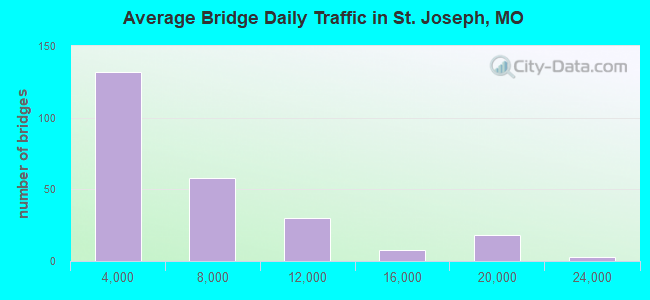
- 1,461,760Total average daily traffic
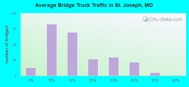
- 229,337Total average daily truck traffic
- National Bridge Inventory (NBI) Registered Bridges for St. Joseph
- No street view available for this location
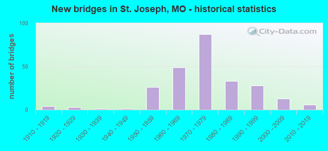
- New bridges - historical statistics
- 41910-1919
- 31920-1929
- 11930-1939
- 11940-1949
- 261950-1959
- 491960-1969
- 871970-1979
- 331980-1989
- 281990-1999
- 132000-2009
- 62010-2019
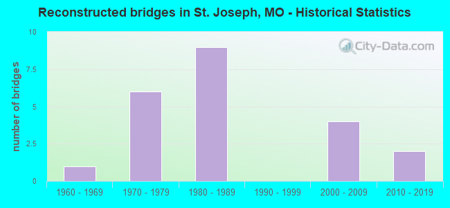
- Reconstructed bridges - Historical Statistics
- 11960-1969
- 61970-1979
- 91980-1989
- 01990-1999
- 42000-2009
- 22010-2019
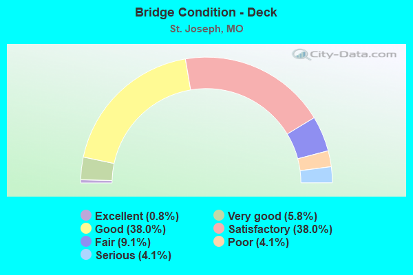
- Bridge Condition - Deck
- 0.8%Excellent
- 5.8%Very good
- 38.0%Good
- 38.0%Satisfactory
- 9.1%Fair
- 4.1%Poor
- 4.1%Serious
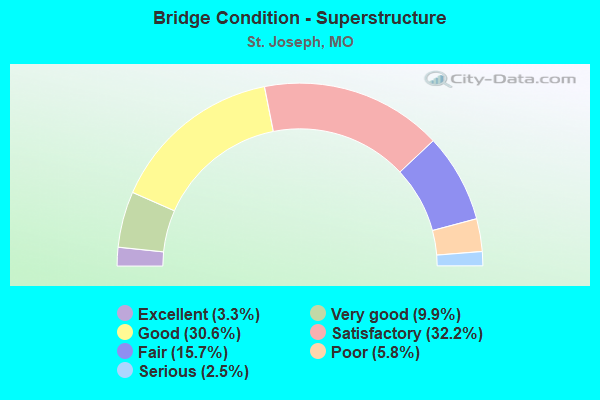
- Bridge Condition - Superstructure
- 3.3%Excellent
- 9.9%Very good
- 30.6%Good
- 32.2%Satisfactory
- 15.7%Fair
- 5.8%Poor
- 2.5%Serious
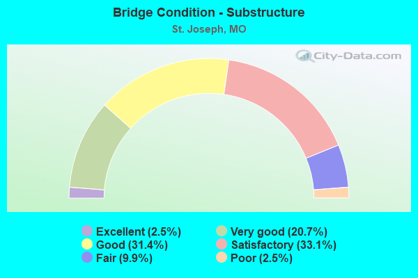
- Bridge Condition - Substructure
- 2.5%Excellent
- 20.7%Very good
- 31.4%Good
- 33.1%Satisfactory
- 9.9%Fair
- 2.5%Poor
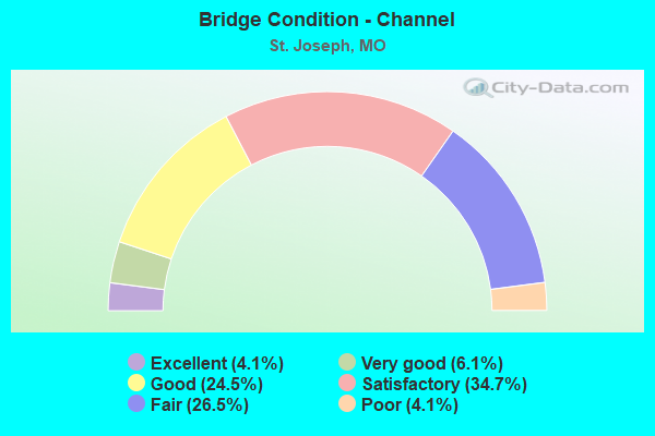
- Bridge Condition - Channel
- 4.1%Excellent
- 6.1%Very good
- 24.5%Good
- 34.7%Satisfactory
- 26.5%Fair
- 4.1%Poor
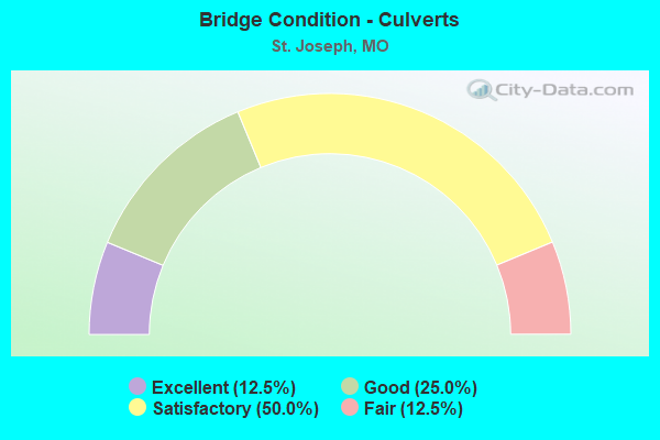
- Bridge Condition - Culverts
- 12.5%Excellent
- 25.0%Good
- 50.0%Satisfactory
- 12.5%Fair
Find on map >> Show street view
Structure Number: 3, Location: S 14 T 57 N R 35 W (Lat: 39.755261, Lng: -94.790350), Route carried "under" structure: Interstate 29, Year Built: 1958, Structure Length: 0. m, Average Daily Traffic: 19,203 (year 2021), Truck Traffic: 18%, Features Intersected: IS 29, Facility Carried by Structure: RT YY E
Minimum Vertical Clearance: 5.03m (16.50ft), Kilometerpoint: 124.955, Lanes on structure: 2, Lanes under structure: 2, Material/Design: Steel continuous, Design/Construction: Stringer/Multi-beam, Length of Maximum Span: 17.1m (56.1ft)
Find on map >> Show street view
Structure Number: 3, Location: S 14 T 57 N R 35 W (Lat: 39.755261, Lng: -94.790350), Route carried "under" structure: Interstate 29, Year Built: 1958, Structure Length: 0. m, Average Daily Traffic: 19,688 (year 2021), Truck Traffic: 28%, Features Intersected: IS 29, Facility Carried by Structure: RT YY E
Minimum Vertical Clearance: 5.00m (16.40ft), Kilometerpoint: 82.230, Lanes on structure: 2, Lanes under structure: 2, Material/Design: Steel continuous, Design/Construction: Stringer/Multi-beam, Length of Maximum Span: 17.1m (56.1ft)
Find on map >> Show street view
Structure Number: 3051, Location: S 20 T 57 N R 35 W (Lat: 39.748725, Lng: -94.855150), Route carried "under" structure: State highway 759, Year Built: 1985, Structure Length: 0. m, Average Daily Traffic: 5,708 (year 2021), Truck Traffic: 5%, Features Intersected: MO 759, Facility Carried by Structure: US 36 W
Minimum Vertical Clearance: 7.67m (25.16ft), Kilometerpoint: 0.460, Lanes on structure: 2, Lanes under structure: 2, Material/Design: Steel continuous, Design/Construction: Stringer/Multi-beam, Length of Maximum Span: 29.0m (95.1ft)
Find on map >> Show street view
Structure Number: 3051, Location: S 20 T 57 N R 35 W (Lat: 39.748725, Lng: -94.855150), Route carried "under" structure: State highway 759, Year Built: 1985, Structure Length: 0. m, Average Daily Traffic: 6,732 (year 2021), Truck Traffic: 29%, Features Intersected: MO 759, Facility Carried by Structure: US 36 W
Minimum Vertical Clearance: 7.67m (25.16ft), Kilometerpoint: 2.963, Lanes on structure: 2, Lanes under structure: 2, Material/Design: Steel continuous, Design/Construction: Stringer/Multi-beam, Length of Maximum Span: 29.0m (95.1ft)
Find on map >> Show street view
Structure Number: 3052, Location: S 20 T 57 N R 35 W (Lat: 39.748133, Lng: -94.856669), Route carried "under" structure: State highway 759, Year Built: 1983, Structure Length: 0. m, Average Daily Traffic: 5,708 (year 2021), Truck Traffic: 5%, Features Intersected: MO 759, Facility Carried by Structure: US 36 E
Minimum Vertical Clearance: 8.10m (26.57ft), Kilometerpoint: 0.526, Lanes on structure: 2, Lanes under structure: 2, Material/Design: Steel continuous, Design/Construction: Stringer/Multi-beam, Length of Maximum Span: 26.8m (87.9ft)
Find on map >> Show street view
Structure Number: 3052, Location: S 20 T 57 N R 35 W (Lat: 39.748133, Lng: -94.856669), Route carried "under" structure: State highway 759, Year Built: 1983, Structure Length: 0. m, Average Daily Traffic: 6,732 (year 2021), Truck Traffic: 29%, Features Intersected: MO 759, Facility Carried by Structure: US 36 E
Minimum Vertical Clearance: 7.95m (26.08ft), Kilometerpoint: 2.892, Lanes on structure: 2, Lanes under structure: 2, Material/Design: Steel continuous, Design/Construction: Stringer/Multi-beam, Length of Maximum Span: 26.8m (87.9ft)
Find on map >> Show street view
Structure Number: 31614, Location: S 25 T 57 N R 35 W (Lat: 39.724056, Lng: -94.768086), Route carried "under" structure: City street , Year Built: 2007, Structure Length: 0. m, Average Daily Traffic: 221 (year 2021), Truck Traffic: 15%, Features Intersected: CST EASTON RD, Facility Carried by Structure: RT AC S
Minimum Vertical Clearance: 8.48m (27.82ft), Kilometerpoint: 5.911, Lanes on structure: 2, Lanes under structure: 2, Material/Design: Prestressed concrete continuous, Design/Construction: Tee Beam, Length of Maximum Span: 39.6m (129.9ft)
Find on map >> Show street view
Structure Number: 3191, Location: S 20 T 57 N R 35 W (Lat: 39.747936, Lng: -94.856108), Route carried "under" structure: State highway 759, Year Built: 1982, Structure Length: 0. m, Average Daily Traffic: 6,732 (year 2021), Truck Traffic: 29%, Features Intersected: MO 759, Facility Carried by Structure: RP US36E TO IS229N
Minimum Vertical Clearance: 9.73m (31.92ft), Kilometerpoint: 2.869, Lanes on structure: 1, Lanes under structure: 2, Material/Design: Steel continuous, Design/Construction: Stringer/Multi-beam, Length of Maximum Span: 22.6m (74.1ft)
Find on map >> Show street view
Structure Number: 3192, Location: S 17 T 57 N R 35 W (Lat: 39.749358, Lng: -94.855667), Route carried "under" structure: State highway 759, Year Built: 1983, Structure Length: 0. m, Average Daily Traffic: 5,708 (year 2021), Truck Traffic: 5%, Features Intersected: MO 759
Minimum Vertical Clearance: 5.13m (16.83ft), Kilometerpoint: 0.396, Lanes on structure: 1, Lanes under structure: 2, Material/Design: Steel continuous, Design/Construction: Stringer/Multi-beam, Length of Maximum Span: 24.4m (80.1ft)
Find on map >> Show street view
Structure Number: 3192, Location: S 17 T 57 N R 35 W (Lat: 39.749358, Lng: -94.855667), Route carried "under" structure: State highway 759, Year Built: 1983, Structure Length: 0. m, Average Daily Traffic: 6,732 (year 2021), Truck Traffic: 29%, Features Intersected: MO 759
Minimum Vertical Clearance: 5.23m (17.16ft), Kilometerpoint: 3.011, Lanes on structure: 1, Lanes under structure: 1, Material/Design: Steel continuous, Design/Construction: Stringer/Multi-beam, Length of Maximum Span: 24.4m (80.1ft)
Find on map >> Show street view
Structure Number: 35175, Location: S 18 T 57 N R 34 W (Lat: 39.747864, Lng: -94.751800), Route carried "under" structure: US 36, Year Built: 2016, Structure Length: 0. m, Average Daily Traffic: 7,665 (year 2021), Truck Traffic: 25%, Features Intersected: US 36, Facility Carried by Structure: AG EXPO WAY S
Minimum Vertical Clearance: 5.21m (17.09ft), Kilometerpoint: 9.708, Lanes on structure: 3, Lanes under structure: 2, Material/Design: Prestressed concrete, Design/Construction: Stringer/Multi-beam, Length of Maximum Span: 24.1m (79.1ft)
Find on map >> Show street view
Structure Number: 35175, Location: S 18 T 57 N R 34 W (Lat: 39.747864, Lng: -94.751800), Route carried "under" structure: US 36, Year Built: 2016, Structure Length: 0. m, Average Daily Traffic: 7,174 (year 2021), Truck Traffic: 20%, Features Intersected: US 36, Facility Carried by Structure: AG EXPO WAY S
Minimum Vertical Clearance: 5.11m (16.77ft), Kilometerpoint: 300.386, Lanes on structure: 3, Lanes under structure: 2, Material/Design: Prestressed concrete, Design/Construction: Stringer/Multi-beam, Length of Maximum Span: 24.1m (79.1ft)
Find on map >> Show street view
Structure Number: 3941, Location: S 26 T 57 N R 35 W (Lat: 39.731675, Lng: -94.801006), Route carried "under" structure: City street , Year Built: 1990, Structure Length: 0. m, Average Daily Traffic: 969 (year 2021), Truck Traffic: 9%, Features Intersected: CST EASTON RD, Facility Carried by Structure: US 169 S
Minimum Vertical Clearance: 5.82m (19.09ft), Kilometerpoint: 2.929, Lanes on structure: 4, Lanes under structure: 2, Material/Design: Prestressed concrete continuous, Design/Construction: Stringer/Multi-beam, Length of Maximum Span: 18.9m (62.0ft)
Find on map >> Show street view
Structure Number: 4, Location: S 23 T 57 N R 35 W (Lat: 39.740814, Lng: -94.788847), Route carried "under" structure: Interstate 29, Year Built: 1958, Structure Length: 0. m, Average Daily Traffic: 18,709 (year 2021), Truck Traffic: 28%, Features Intersected: IS 29, Facility Carried by Structure: PICKETT RD E
Minimum Vertical Clearance: 5.28m (17.32ft), Kilometerpoint: 80.615, Lanes on structure: 2, Lanes under structure: 2, Material/Design: Steel continuous, Design/Construction: Stringer/Multi-beam, Length of Maximum Span: 17.1m (56.1ft)
Find on map >> Show street view
Structure Number: 4, Location: S 23 T 57 N R 35 W (Lat: 39.740814, Lng: -94.788847), Route carried "under" structure: Interstate 29, Year Built: 1958, Structure Length: 0. m, Average Daily Traffic: 18,157 (year 2021), Truck Traffic: 20%, Features Intersected: IS 29, Facility Carried by Structure: PICKETT RD E
Minimum Vertical Clearance: 4.88m (16.01ft), Kilometerpoint: 126.567, Lanes on structure: 2, Lanes under structure: 2, Material/Design: Steel continuous, Design/Construction: Stringer/Multi-beam, Length of Maximum Span: 17.1m (56.1ft)
Find on map >> Show street view
Structure Number: 4386, Location: S 17 T 57 N R 35 W (Lat: 39.748639, Lng: -94.845531), Route carried "under" structure: City street , Year Built: 1996, Structure Length: 0. m, Average Daily Traffic: 2,418 (year 2021), Truck Traffic: 6%, Features Intersected: CST 11TH ST, Facility Carried by Structure: US 36 W
Minimum Vertical Clearance: 5.73m (18.80ft), Kilometerpoint: 1.458, Lanes on structure: 2, Lanes under structure: 2, Material/Design: Steel continuous, Design/Construction: Stringer/Multi-beam, Length of Maximum Span: 45.3m (148.6ft)
Find on map >> Show street view
Structure Number: 4386, Location: S 17 T 57 N R 35 W (Lat: 39.748639, Lng: -94.845531), Route carried "under" structure: City street , Year Built: 1996, Structure Length: 0. m, Average Daily Traffic: 642 (year 2021), Truck Traffic: 5%, Features Intersected: CST 13TH ST, Facility Carried by Structure: US 36 W
Minimum Vertical Clearance: 4.75m (15.58ft), Kilometerpoint: 1.635, Lanes on structure: 2, Lanes under structure: 2, Material/Design: Steel continuous, Design/Construction: Stringer/Multi-beam, Length of Maximum Span: 45.3m (148.6ft)
Find on map >> Show street view
Structure Number: 4386, Location: S 17 T 57 N R 35 W (Lat: 39.748639, Lng: -94.845531), Route carried "under" structure: City street , Year Built: 1996, Structure Length: 0. m, Average Daily Traffic: 464 (year 2021), Truck Traffic: 4%, Features Intersected: CST PACIFIC ST, Facility Carried by Structure: US 36 W
Minimum Vertical Clearance: 5.64m (18.50ft), Kilometerpoint: 0.480, Lanes on structure: 2, Lanes under structure: 2, Material/Design: Steel continuous, Design/Construction: Stringer/Multi-beam, Length of Maximum Span: 45.3m (148.6ft)
Find on map >> Show street view
Structure Number: 4386, Location: S 17 T 57 N R 35 W (Lat: 39.748639, Lng: -94.845531), Route carried "under" structure: City street , Year Built: 1996, Structure Length: 0. m, Average Daily Traffic: 642 (year 2021), Truck Traffic: 5%, Features Intersected: CST 12TH ST, Facility Carried by Structure: US 36 W
Minimum Vertical Clearance: 6.19m (20.31ft), Kilometerpoint: 0.558, Lanes on structure: 2, Lanes under structure: 2, Material/Design: Steel continuous, Design/Construction: Stringer/Multi-beam, Length of Maximum Span: 45.3m (148.6ft)
Find on map >> Show street view
Structure Number: 4387, Location: S 17 T 57 N R 35 W (Lat: 39.748481, Lng: -94.845556), Route carried "under" structure: City street , Year Built: 1996, Structure Length: 0. m, Average Daily Traffic: 464 (year 2021), Truck Traffic: 4%, Features Intersected: CST PACIFIC ST, Facility Carried by Structure: US 36 E
Minimum Vertical Clearance: 6.12m (20.08ft), Kilometerpoint: 0.465, Lanes on structure: 2, Lanes under structure: 2, Material/Design: Steel continuous, Design/Construction: Stringer/Multi-beam, Length of Maximum Span: 39.9m (130.9ft)
Find on map >> Show street view
Structure Number: 4387, Location: S 17 T 57 N R 35 W (Lat: 39.748481, Lng: -94.845556), Route carried "under" structure: City street , Year Built: 1996, Structure Length: 0. m, Average Daily Traffic: 642 (year 2021), Truck Traffic: 5%, Features Intersected: CST 12TH ST, Facility Carried by Structure: US 36 E
Minimum Vertical Clearance: 6.05m (19.85ft), Kilometerpoint: 0.581, Lanes on structure: 2, Lanes under structure: 2, Material/Design: Steel continuous, Design/Construction: Stringer/Multi-beam, Length of Maximum Span: 39.9m (130.9ft)
Find on map >> Show street view
Structure Number: 4387, Location: S 17 T 57 N R 35 W (Lat: 39.748481, Lng: -94.845556), Route carried "under" structure: City street , Year Built: 1996, Structure Length: 0. m, Average Daily Traffic: 642 (year 2021), Truck Traffic: 5%, Features Intersected: CST 13TH ST, Facility Carried by Structure: US 36 E
Minimum Vertical Clearance: 5.13m (16.83ft), Kilometerpoint: 1.653, Lanes on structure: 2, Lanes under structure: 2, Material/Design: Steel continuous, Design/Construction: Stringer/Multi-beam, Length of Maximum Span: 39.9m (130.9ft)
Find on map >> Show street view
Structure Number: 4387, Location: S 17 T 57 N R 35 W (Lat: 39.748481, Lng: -94.845556), Route carried "under" structure: City street , Year Built: 1996, Structure Length: 0. m, Average Daily Traffic: 2,418 (year 2021), Truck Traffic: 6%, Features Intersected: CST 11TH ST, Facility Carried by Structure: US 36 E
Minimum Vertical Clearance: 4.88m (16.01ft), Kilometerpoint: 1.471, Lanes on structure: 2, Lanes under structure: 2, Material/Design: Steel continuous, Design/Construction: Stringer/Multi-beam, Length of Maximum Span: 39.9m (130.9ft)
Find on map >> Show street view
Structure Number: 4393, Location: S 17 T 57 N R 35 W (Lat: 39.749194, Lng: -94.847972), Route carried "under" structure: Business State highway 29, Year Built: 1996, Structure Length: 0. m, Average Daily Traffic: 2,706 (year 2021), Truck Traffic: 5%, Features Intersected: LP 29, Facility Carried by Structure: US 36 E
Minimum Vertical Clearance: 4.88m (16.01ft), Kilometerpoint: 6.865, Lanes on structure: 2, Lanes under structure: 2, Material/Design: Prestressed concrete continuous, Design/Construction: Stringer/Multi-beam, Length of Maximum Span: 17.1m (56.1ft)
Find on map >> Show street view
Structure Number: 4394, Location: S 17 T 57 N R 35 W (Lat: 39.749339, Lng: -94.847956), Route carried "under" structure: Business State highway 29, Year Built: 1996, Structure Length: 0. m, Average Daily Traffic: 2,706 (year 2021), Truck Traffic: 5%, Features Intersected: LP 29, Facility Carried by Structure: US 36 W
Minimum Vertical Clearance: 5.49m (18.01ft), Kilometerpoint: 6.882, Lanes on structure: 2, Lanes under structure: 2, Material/Design: Prestressed concrete continuous, Design/Construction: Stringer/Multi-beam, Length of Maximum Span: 17.1m (56.1ft)
Find on map >> Show street view
Structure Number: 473, Location: S 21 T 57 N R 35 W (Lat: 39.747297, Lng: -94.827081), Route carried "under" structure: US 36, Year Built: 1961, Structure Length: 0. m, Average Daily Traffic: 11,527 (year 2021), Truck Traffic: 7%, Features Intersected: US 36, Facility Carried by Structure: AGENCY RD S
Minimum Vertical Clearance: 5.11m (16.77ft), Kilometerpoint: 2.932, Lanes on structure: 2, Lanes under structure: 2, Material/Design: Concrete continuous, Design/Construction: Box Beam or Girders - Single/Spread, Length of Maximum Span: 23.8m (78.1ft)
Find on map >> Show street view
Structure Number: 473, Location: S 21 T 57 N R 35 W (Lat: 39.747297, Lng: -94.827081), Route carried "under" structure: US 36, Year Built: 1961, Structure Length: 0. m, Average Daily Traffic: 11,941 (year 2021), Truck Traffic: 7%, Features Intersected: US 36, Facility Carried by Structure: AGENCY RD S
Minimum Vertical Clearance: 5.03m (16.50ft), Kilometerpoint: 307.163, Lanes on structure: 2, Lanes under structure: 2, Material/Design: Concrete continuous, Design/Construction: Box Beam or Girders - Single/Spread, Length of Maximum Span: 23.8m (78.1ft)
Find on map >> Show street view
Structure Number: 474, Location: S 21 T 57 N R 35 W (Lat: 39.747608, Lng: -94.824603), Route carried "under" structure: City street , Year Built: 1961, Structure Length: 0. m, Average Daily Traffic: 3,606 (year 2021), Truck Traffic: 4%, Features Intersected: CST 28TH ST, Facility Carried by Structure: US 36 E
Minimum Vertical Clearance: 5.38m (17.65ft), Kilometerpoint: 1.571, Lanes on structure: 2, Lanes under structure: 2, Material/Design: Concrete continuous, Design/Construction: Slab, Length of Maximum Span: 17.7m (58.1ft)
Find on map >> Show street view
Structure Number: 475, Location: S 21 T 57 N R 35 W (Lat: 39.747694, Lng: -94.824531), Route carried "under" structure: City street , Year Built: 1961, Structure Length: 0. m, Average Daily Traffic: 5,458 (year 2021), Truck Traffic: 5%, Features Intersected: CST 28TH ST, Facility Carried by Structure: US 36 W
Minimum Vertical Clearance: 5.26m (17.26ft), Kilometerpoint: 1.561, Lanes on structure: 2, Lanes under structure: 2, Material/Design: Concrete continuous, Design/Construction: Slab, Length of Maximum Span: 17.7m (58.1ft)
Find on map >> Show street view
Structure Number: 476, Location: S 22 T 57 N R 35 W (Lat: 39.747636, Lng: -94.812864), Route carried "under" structure: US 36, Year Built: 1961, Structure Length: 0. m, Average Daily Traffic: 11,161 (year 2021), Truck Traffic: 8%, Features Intersected: US 36, Facility Carried by Structure: 33RD ST S
Minimum Vertical Clearance: 4.85m (15.91ft), Kilometerpoint: 4.154, Lanes on structure: 2, Lanes under structure: 2, Material/Design: Concrete continuous, Design/Construction: Box Beam or Girders - Single/Spread, Length of Maximum Span: 23.2m (76.1ft)
Find on map >> Show street view
Structure Number: 476, Location: S 22 T 57 N R 35 W (Lat: 39.747636, Lng: -94.812864), Route carried "under" structure: US 36, Year Built: 1961, Structure Length: 0. m, Average Daily Traffic: 11,331 (year 2021), Truck Traffic: 8%, Features Intersected: US 36, Facility Carried by Structure: 33RD ST S
Minimum Vertical Clearance: 4.85m (15.91ft), Kilometerpoint: 305.940, Lanes on structure: 2, Lanes under structure: 2, Material/Design: Concrete continuous, Design/Construction: Box Beam or Girders - Single/Spread, Length of Maximum Span: 23.2m (76.1ft)
Find on map >> Show street view
Structure Number: 477, Location: S 23 T 57 N R 35 W (Lat: 39.746942, Lng: -94.801875), Route carried "under" structure: US 169, Year Built: 1961, Structure Length: 0. m, Average Daily Traffic: 21,891 (year 2021), Truck Traffic: 8%, Features Intersected: US 169, Facility Carried by Structure: US 36 E
Minimum Vertical Clearance: 6.40m (21.00ft), Kilometerpoint: 119.632, Lanes on structure: 4, Lanes under structure: 4, Material/Design: Steel continuous, Design/Construction: Stringer/Multi-beam, Length of Maximum Span: 21.6m (70.9ft)
Find on map >> Show street view
Structure Number: 5, Location: S 26 T 57 N R 35 W (Lat: 39.724192, Lng: -94.788706), Route carried "under" structure: US 169, Year Built: 1958, Structure Length: 0. m, Average Daily Traffic: 8,545 (year 2021), Truck Traffic: 13%, Features Intersected: US 169, Facility Carried by Structure: IS 29 S
Minimum Vertical Clearance: 4.60m (15.09ft), Kilometerpoint: 122.829, Lanes on structure: 2, Lanes under structure: 2, Material/Design: Steel continuous, Design/Construction: Stringer/Multi-beam, Length of Maximum Span: 17.4m (57.1ft)
Find on map >> Show street view
Structure Number: 508, Location: S 26 T 58 N R 35 W (Lat: 39.806733, Lng: -94.801028), Route carried "under" structure: Interstate 29, Year Built: 1962, Structure Length: 0. m, Average Daily Traffic: 16,479 (year 2021), Truck Traffic: 28%, Features Intersected: IS 29, Facility Carried by Structure: COOK RD E
Minimum Vertical Clearance: 4.95m (16.24ft), Kilometerpoint: 88.022, Lanes on structure: 2, Lanes under structure: 2, Material/Design: Steel continuous, Design/Construction: Stringer/Multi-beam, Length of Maximum Span: 20.7m (67.9ft)
Find on map >> Show street view
Structure Number: 508, Location: S 26 T 58 N R 35 W (Lat: 39.806733, Lng: -94.801028), Route carried "under" structure: Interstate 29, Year Built: 1962, Structure Length: 0. m, Average Daily Traffic: 18,030 (year 2021), Truck Traffic: 30%, Features Intersected: IS 29, Facility Carried by Structure: COOK RD E
Minimum Vertical Clearance: 4.80m (15.75ft), Kilometerpoint: 119.158, Lanes on structure: 2, Lanes under structure: 2, Material/Design: Steel continuous, Design/Construction: Stringer/Multi-beam, Length of Maximum Span: 20.7m (67.9ft)
Find on map >> Show street view
Structure Number: 509, Location: S 2 T 57 N R 35 W (Lat: 39.792136, Lng: -94.796069), Route carried "under" structure: Interstate 29, Year Built: 1962, Structure Length: 0. m, Average Daily Traffic: 16,479 (year 2021), Truck Traffic: 28%, Features Intersected: IS 29, Facility Carried by Structure: GENE FIELD RD E
Minimum Vertical Clearance: 4.85m (15.91ft), Kilometerpoint: 86.354, Lanes on structure: 2, Lanes under structure: 2, Material/Design: Steel continuous, Design/Construction: Stringer/Multi-beam, Length of Maximum Span: 20.7m (67.9ft)
Find on map >> Show street view
Structure Number: 509, Location: S 2 T 57 N R 35 W (Lat: 39.792136, Lng: -94.796069), Route carried "under" structure: Interstate 29, Year Built: 1962, Structure Length: 0. m, Average Daily Traffic: 18,030 (year 2021), Truck Traffic: 30%, Features Intersected: IS 29, Facility Carried by Structure: GENE FIELD RD E
Minimum Vertical Clearance: 4.83m (15.85ft), Kilometerpoint: 120.830, Lanes on structure: 2, Lanes under structure: 2, Material/Design: Steel continuous, Design/Construction: Stringer/Multi-beam, Length of Maximum Span: 20.7m (67.9ft)
Find on map >> Show street view
Structure Number: 513, Location: S 21 T 57 N R 35 W (Lat: 39.746489, Lng: -94.834097), Route carried "under" structure: US 36, Year Built: 1961, Structure Length: 0. m, Average Daily Traffic: 11,941 (year 2021), Truck Traffic: 7%, Features Intersected: US 36, Facility Carried by Structure: 22ND ST N
Minimum Vertical Clearance: 4.73m (15.52ft), Kilometerpoint: 307.778, Lanes on structure: 2, Lanes under structure: 2, Material/Design: Concrete, Design/Construction: Box Beam or Girders - Single/Spread, Length of Maximum Span: 23.2m (76.1ft)
Find on map >> Show street view
Structure Number: 513, Location: S 21 T 57 N R 35 W (Lat: 39.746489, Lng: -94.834097), Route carried "under" structure: US 36, Year Built: 1961, Structure Length: 0. m, Average Daily Traffic: 11,190 (year 2021), Truck Traffic: 7%, Features Intersected: US 36, Facility Carried by Structure: 22ND ST N
Minimum Vertical Clearance: 5.03m (16.50ft), Kilometerpoint: 2.317, Lanes on structure: 2, Lanes under structure: 2, Material/Design: Concrete, Design/Construction: Box Beam or Girders - Single/Spread, Length of Maximum Span: 23.2m (76.1ft)
Find on map >> Show street view
Structure Number: 514, Location: S 22 T 57 N R 35 W (Lat: 39.747650, Lng: -94.817292), Route carried "under" structure: City street , Year Built: 1961, Structure Length: 0. m, Average Daily Traffic: 3,201 (year 2021), Truck Traffic: 7%, Features Intersected: CST SOUTHWEST PKWY, Facility Carried by Structure: US 36 E
Minimum Vertical Clearance: 8.79m (28.84ft), Kilometerpoint: 0.774, Lanes on structure: 2, Lanes under structure: 2, Material/Design: Concrete continuous, Design/Construction: Slab, Length of Maximum Span: 18.3m (60.0ft)
Find on map >> Show street view
Structure Number: 515, Location: S 22 T 57 N R 35 W (Lat: 39.747747, Lng: -94.817389), Route carried "under" structure: City street , Year Built: 1961, Structure Length: 0. m, Average Daily Traffic: 4,116 (year 2021), Truck Traffic: 7%, Features Intersected: CST SOUTHWEST PKWY, Facility Carried by Structure: US 36 W
Minimum Vertical Clearance: 8.79m (28.84ft), Kilometerpoint: 0.763, Lanes on structure: 2, Lanes under structure: 2, Material/Design: Concrete continuous, Design/Construction: Slab, Length of Maximum Span: 18.3m (60.0ft)
Find on map >> Show street view
Structure Number: 6, Location: S 26 T 57 N R 35 W (Lat: 39.724214, Lng: -94.788422), Route carried "under" structure: US 169, Year Built: 1958, Structure Length: 0. m, Average Daily Traffic: 8,243 (year 2021), Truck Traffic: 13%, Features Intersected: US 169, Facility Carried by Structure: IS 29 N
Minimum Vertical Clearance: 2.97m (9.74ft), Kilometerpoint: 122.853, Lanes on structure: 2, Lanes under structure: 4, Material/Design: Steel continuous, Design/Construction: Stringer/Multi-beam, Length of Maximum Span: 17.4m (57.1ft)
Find on map >> Show street view
Structure Number: 6202, Location: S 20 T 57 N R 35 W (Lat: 39.748892, Lng: -94.851614), Route carried "under" structure: Interstate 229, Year Built: 1951, Structure Length: 0. m, Average Daily Traffic: 7,100 (year 2021), Truck Traffic: 12%, Features Intersected: IS 229, Facility Carried by Structure: US 36 E
Minimum Vertical Clearance: 4.90m (16.08ft), Kilometerpoint: 8.320, Lanes on structure: 4, Lanes under structure: 3, Material/Design: Steel continuous, Design/Construction: Stringer/Multi-beam, Length of Maximum Span: 36.2m (118.8ft)
Find on map >> Show street view
Structure Number: 6202, Location: S 20 T 57 N R 35 W (Lat: 39.748892, Lng: -94.851614), Route carried "under" structure: Interstate 229, Year Built: 1951, Structure Length: 0. m, Average Daily Traffic: 7,963 (year 2021), Truck Traffic: 17%, Features Intersected: IS 229, Facility Carried by Structure: US 36 E
Minimum Vertical Clearance: 5.00m (16.40ft), Kilometerpoint: 15.971, Lanes on structure: 4, Lanes under structure: 3, Material/Design: Steel continuous, Design/Construction: Stringer/Multi-beam, Length of Maximum Span: 36.2m (118.8ft)
Find on map >> Show street view
Structure Number: 6202, Location: S 20 T 57 N R 35 W (Lat: 39.748892, Lng: -94.851614), Route carried "under" structure: City street , Year Built: 1951, Structure Length: 0. m, Average Daily Traffic: 3,715 (year 2021), Truck Traffic: 9%, Features Intersected: CST 6TH ST, Facility Carried by Structure: US 36 E
Minimum Vertical Clearance: 30+ m (98+ ft), Kilometerpoint: 3.180, Lanes on structure: 4, Lanes under structure: 2, Material/Design: Steel continuous, Design/Construction: Stringer/Multi-beam, Length of Maximum Span: 36.2m (118.8ft)
Find on map >> Show street view
Structure Number: 6202, Location: S 20 T 57 N R 35 W (Lat: 39.748892, Lng: -94.851614), Route carried "under" structure: City street , Year Built: 1951, Structure Length: 0. m, Average Daily Traffic: 582 (year 2021), Truck Traffic: 5%, Features Intersected: CST 8TH ST, Facility Carried by Structure: US 36 E
Minimum Vertical Clearance: 30+ m (98+ ft), Kilometerpoint: 2.231, Lanes on structure: 4, Lanes under structure: 2, Material/Design: Steel continuous, Design/Construction: Stringer/Multi-beam, Length of Maximum Span: 36.2m (118.8ft)
Find on map >> Show street view
Structure Number: 6203, Location: S 20 T 57 N R 35 W (Lat: 39.749100, Lng: -94.849333), Route carried "under" structure: Business State highway 29, Year Built: 1961, Structure Length: 0. m, Average Daily Traffic: 4,438 (year 2021), Truck Traffic: 11%, Features Intersected: LP 29, Facility Carried by Structure: US 36 E
Minimum Vertical Clearance: 6.68m (21.92ft), Kilometerpoint: 15.912, Lanes on structure: 4, Lanes under structure: 2, Material/Design: Concrete continuous, Design/Construction: Slab, Length of Maximum Span: 19.2m (63.0ft)
Find on map >> Show street view
Structure Number: 789, Location: S 26 T 58 N R 35 W (Lat: 39.815100, Lng: -94.803553), Route carried "under" structure: Interstate 29, Year Built: 1962, Structure Length: 0. m, Average Daily Traffic: 16,479 (year 2021), Truck Traffic: 28%, Features Intersected: IS 29, Facility Carried by Structure: US 169 S
Minimum Vertical Clearance: 4.83m (15.85ft), Kilometerpoint: 88.989, Lanes on structure: 4, Lanes under structure: 2, Material/Design: Steel continuous, Design/Construction: Stringer/Multi-beam, Length of Maximum Span: 25.6m (84.0ft)
Find on map >> Show street view
Structure Number: 789, Location: S 26 T 58 N R 35 W (Lat: 39.815100, Lng: -94.803553), Route carried "under" structure: Interstate 29, Year Built: 1962, Structure Length: 0. m, Average Daily Traffic: 12,945 (year 2021), Truck Traffic: 30%, Features Intersected: IS 29, Facility Carried by Structure: US 169 S
Minimum Vertical Clearance: 4.98m (16.34ft), Kilometerpoint: 118.227, Lanes on structure: 4, Lanes under structure: 2, Material/Design: Steel continuous, Design/Construction: Stringer/Multi-beam, Length of Maximum Span: 25.6m (84.0ft)
Find on map >> Show street view
Structure Number: 952, Location: S 18 T 58 N R 35 W (Lat: 39.835425, Lng: -94.865006), Route carried "under" structure: Interstate 229, Year Built: 1983, Structure Length: 0. m, Average Daily Traffic: 2,692 (year 2021), Truck Traffic: 28%, Features Intersected: IS 229, Facility Carried by Structure: RT K S
Minimum Vertical Clearance: 4.98m (16.34ft), Kilometerpoint: 5.945, Lanes on structure: 2, Lanes under structure: 2, Material/Design: Steel continuous, Design/Construction: Stringer/Multi-beam, Length of Maximum Span: 37.5m (123.0ft)
Find on map >> Show street view
Structure Number: 952, Location: S 18 T 58 N R 35 W (Lat: 39.835425, Lng: -94.865006), Route carried "under" structure: Interstate 229, Year Built: 1983, Structure Length: 0. m, Average Daily Traffic: 3,041 (year 2021), Truck Traffic: 21%, Features Intersected: IS 229, Facility Carried by Structure: RT K S
Minimum Vertical Clearance: 5.11m (16.77ft), Kilometerpoint: 18.311, Lanes on structure: 2, Lanes under structure: 2, Material/Design: Steel continuous, Design/Construction: Stringer/Multi-beam, Length of Maximum Span: 37.5m (123.0ft)
Find on map >> Show street view
Structure Number: 953, Location: S 30 T 57 N R 35 W (Lat: 39.806883, Lng: -94.866042), Route carried "under" structure: Interstate 229, Year Built: 1983, Structure Length: 0. m, Average Daily Traffic: 3,068 (year 2021), Truck Traffic: 25%, Features Intersected: IS 229, Facility Carried by Structure: COOK RD E
Minimum Vertical Clearance: 5.28m (17.32ft), Kilometerpoint: 9.139, Lanes on structure: 2, Lanes under structure: 2, Material/Design: Steel continuous, Design/Construction: Stringer/Multi-beam, Length of Maximum Span: 34.7m (113.8ft)
Find on map >> Show street view
Structure Number: 953, Location: S 30 T 57 N R 35 W (Lat: 39.806883, Lng: -94.866042), Route carried "under" structure: Interstate 229, Year Built: 1983, Structure Length: 0. m, Average Daily Traffic: 2,476 (year 2021), Truck Traffic: 21%, Features Intersected: IS 229, Facility Carried by Structure: COOK RD E
Minimum Vertical Clearance: 5.23m (17.16ft), Kilometerpoint: 15.144, Lanes on structure: 2, Lanes under structure: 2, Material/Design: Steel continuous, Design/Construction: Stringer/Multi-beam, Length of Maximum Span: 34.7m (113.8ft)
Find on map >> Show street view
Structure Number: 954, Location: S 31 T 57 N R 35 W (Lat: 39.800794, Lng: -94.868572), Route carried "under" structure: Interstate 229, Year Built: 1983, Structure Length: 0. m, Average Daily Traffic: 2,086 (year 2021), Truck Traffic: 22%, Features Intersected: IS 229, Facility Carried by Structure: HUNTOON RD S
Minimum Vertical Clearance: 6.00m (19.69ft), Kilometerpoint: 9.846, Lanes on structure: 2, Lanes under structure: 2, Material/Design: Steel continuous, Design/Construction: Stringer/Multi-beam, Length of Maximum Span: 34.7m (113.8ft)
Find on map >> Show street view
Structure Number: 954, Location: S 31 T 57 N R 35 W (Lat: 39.800794, Lng: -94.868572), Route carried "under" structure: Interstate 229, Year Built: 1983, Structure Length: 0. m, Average Daily Traffic: 2,476 (year 2021), Truck Traffic: 21%, Features Intersected: IS 229, Facility Carried by Structure: HUNTOON RD S
Minimum Vertical Clearance: 5.84m (19.16ft), Kilometerpoint: 14.426, Lanes on structure: 2, Lanes under structure: 2, Material/Design: Steel continuous, Design/Construction: Stringer/Multi-beam, Length of Maximum Span: 34.7m (113.8ft)
Find on map >> Show street view
Structure Number: 955, Location: S 35 T 57 N R 35 W (Lat: 39.709994, Lng: -94.796206), Route carried "under" structure: Interstate 229, Year Built: 1965, Structure Length: 0. m, Average Daily Traffic: 7,342 (year 2021), Truck Traffic: 22%, Features Intersected: IS 229, Facility Carried by Structure: RT A S
Minimum Vertical Clearance: 4.67m (15.32ft), Kilometerpoint: 23.109, Lanes on structure: 2, Lanes under structure: 2, Material/Design: Concrete continuous, Design/Construction: Slab, Length of Maximum Span: 18.3m (60.0ft)
Find on map >> Show street view
Structure Number: 955, Location: S 35 T 57 N R 35 W (Lat: 39.709994, Lng: -94.796206), Route carried "under" structure: Interstate 229, Year Built: 1965, Structure Length: 0. m, Average Daily Traffic: 4,069 (year 2021), Truck Traffic: 19%, Features Intersected: IS 229, Facility Carried by Structure: RT A S
Minimum Vertical Clearance: 4.57m (14.99ft), Kilometerpoint: 1.218, Lanes on structure: 2, Lanes under structure: 2, Material/Design: Concrete continuous, Design/Construction: Slab, Length of Maximum Span: 18.3m (60.0ft)
Find on map >> Show street view
Structure Number: 969, Location: S 19 T 58 N R 35 W (Lat: 39.823294, Lng: -94.866550), Route carried "under" structure: County highway 385, Year Built: 1983, Structure Length: 0. m, Average Daily Traffic: 10 (year 2021), Truck Traffic: 10%, Features Intersected: CRD 385, Facility Carried by Structure: IS 229 S
Minimum Vertical Clearance: 6.43m (21.10ft), Kilometerpoint: 0.752, Lanes on structure: 2, Lanes under structure: 2, Material/Design: Prestressed concrete continuous, Design/Construction: Stringer/Multi-beam, Length of Maximum Span: 20.9m (68.6ft)