Bridge Statistics for Statesville, North Carolina (NC)
Condition, Traffic, Stress, Structural Evaluation, Project Costs
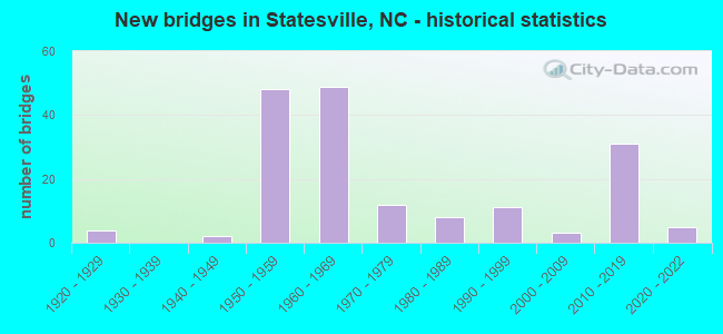
- New bridges - historical statistics
- 41920-1929
- 21940-1949
- 481950-1959
- 491960-1969
- 121970-1979
- 81980-1989
- 111990-1999
- 32000-2009
- 312010-2019
- 52020-2022
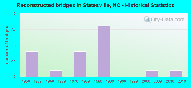
- Reconstructed bridges - Historical Statistics
- 41950-1959
- 11960-1969
- 41970-1979
- 81980-1989
- 01990-1999
- 12000-2009
- 12010-2019
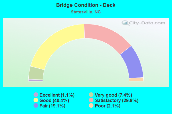
- Bridge Condition - Deck
- 1.1%Excellent
- 7.4%Very good
- 40.4%Good
- 29.8%Satisfactory
- 19.1%Fair
- 2.1%Poor
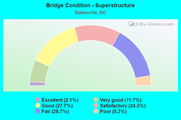
- Bridge Condition - Superstructure
- 2.1%Excellent
- 11.7%Very good
- 27.7%Good
- 24.5%Satisfactory
- 28.7%Fair
- 5.3%Poor
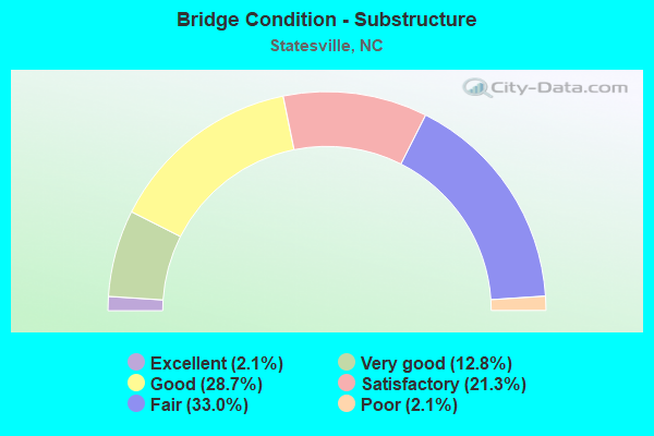
- Bridge Condition - Substructure
- 2.1%Excellent
- 12.8%Very good
- 28.7%Good
- 21.3%Satisfactory
- 33.0%Fair
- 2.1%Poor
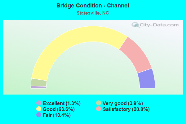
- Bridge Condition - Channel
- 1.3%Excellent
- 3.9%Very good
- 63.6%Good
- 20.8%Satisfactory
- 10.4%Fair
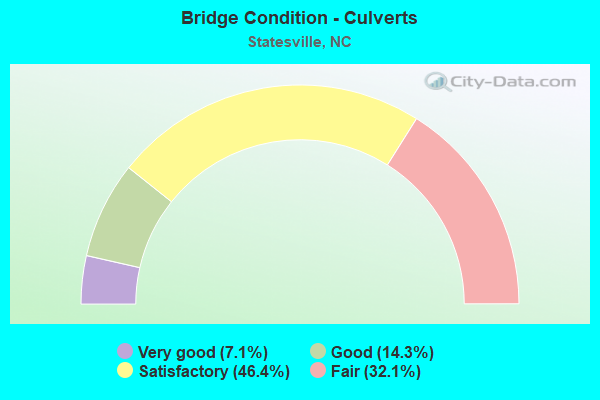
- Bridge Condition - Culverts
- 7.1%Very good
- 14.3%Good
- 46.4%Satisfactory
- 32.1%Fair
Find on map >> Show street view
Structure Number: 970138, Location: 0.2 MI. S. JCT. SR2735 (Lat: 35.772514, Lng: -80.863036), Route carried "on" structure: Interstate 77, Year Built: 1957, Status: Open, Structure Length: 4.90m (16.08ft), Average Daily Traffic: 31,000 (year 2013), Truck Traffic: 16%, Average Future Daily Traffic: 62,000 (year 2040), Design Load: HS 20+Mod, Features Intersected: US70
Minimum Vertical Clearance: 30+ m (98+ ft), Kilometerpoint: 14.816, Lanes on structure: 3, Lanes under structure: 4, Base Highway Network: Yes (Inventory Route: 1, Subroute: 77), Owner: State Highway Agency, Approaching Roadway Width: 11.8m (38.7ft), Skew: 12 degrees, Material/Design: Concrete, Design/Construction: Tee Beam, Number Of Spans In Main Unit: 3, Length of Maximum Span: 17.3m (56.8ft), Curb-To-Curb Width: 12.2m (40.0ft), Out-to-Out Width: 13.8m (45.3ft)
Condition: Deck: Satisfactory, Superstructure: Fair, Substructure: Fair, Operating Rating: 61.6 metric tons, Method Used To Determine Operating Rating: Load Factor (LF), Inventory Rating: 37.1 metric tons, Method Used To Determine Inventory Rating: Load Factor (LF), Structural Evaluation: Somewhat better than minimum adequacy, Deck Geometry: High priority of replacement, Underclear: High priority of corrective action, Approach Roadway Alignment: Equal to present desirable criteria, Designated Inspection Frequency: Every 24 months, Inspection Date: March 2020, Deck Structure Type: Concrete Cast-file-Place, Wearing Surface/Protective System: Wearing Surface: Bituminous
Find on map >> Show street view
Structure Number: 970139, Location: 0.2 MI. S. JCT. SR2735 (Lat: 35.772572, Lng: -80.863267), Route carried "on" structure: Interstate 77, Year Built: 1957, Year Reconstructed: 1964, Status: Open, Structure Length: 5.39m (17.68ft), Average Daily Traffic: 31,000 (year 2013), Truck Traffic: 16%, Average Future Daily Traffic: 62,000 (year 2040), Design Load: HS 20+Mod, Features Intersected: US70
Minimum Vertical Clearance: 30+ m (98+ ft), Kilometerpoint: 14.816, Lanes on structure: 3, Lanes under structure: 4, Base Highway Network: Yes (Inventory Route: 1, Subroute: 77), Owner: State Highway Agency, Approaching Roadway Width: 11.8m (38.7ft), Skew: 12 degrees, Material/Design: Concrete, Design/Construction: Tee Beam, Number Of Spans In Main Unit: 3, Length of Maximum Span: 17.3m (56.8ft), Curb-To-Curb Width: 12.2m (40.0ft), Out-to-Out Width: 13.8m (45.3ft)
Condition: Deck: Satisfactory, Superstructure: Fair, Substructure: Satisfactory, Operating Rating: 57.1 metric tons, Method Used To Determine Operating Rating: Load Factor (LF), Inventory Rating: 34.4 metric tons, Method Used To Determine Inventory Rating: Load Factor (LF), Structural Evaluation: Somewhat better than minimum adequacy, Deck Geometry: High priority of replacement, Underclear: High priority of corrective action, Approach Roadway Alignment: Equal to present desirable criteria, Designated Inspection Frequency: Every 24 months, Inspection Date: March 2020, Deck Structure Type: Concrete Cast-file-Place, Wearing Surface/Protective System: Wearing Surface: Bituminous
Find on map >> Show street view
Structure Number: 970145, Location: 0.1 MI. N. JCT. US70 (Lat: 35.774047, Lng: -80.863203), Route carried "on" structure: Interstate 77, Year Built: 1957, Year Reconstructed: 1964, Status: Open, Structure Length: 5.48m (17.98ft), Average Daily Traffic: 31,000 (year 2013), Truck Traffic: 16%, Average Future Daily Traffic: 62,000 (year 2040), Design Load: HS 20+Mod, Features Intersected: SOUTHERN RAILWAY
Minimum Vertical Clearance: 30+ m (98+ ft), Kilometerpoint: 14.846, Lanes on structure: 3, Base Highway Network: Yes (Inventory Route: 1, Subroute: 77), Owner: State Highway Agency, Approaching Roadway Width: 11.8m (38.7ft), Skew: 11 degrees, Material/Design: Concrete, Design/Construction: Tee Beam, Number Of Spans In Main Unit: 5, Length of Maximum Span: 14.3m (46.9ft), Curb-To-Curb Width: 12.3m (40.4ft), Out-to-Out Width: 13.8m (45.3ft)
Condition: Deck: Fair, Superstructure: Fair, Substructure: Fair, Operating Rating: 57.1 metric tons, Method Used To Determine Operating Rating: Load Factor (LF), Inventory Rating: 33.5 metric tons, Method Used To Determine Inventory Rating: Load Factor (LF), Structural Evaluation: Somewhat better than minimum adequacy, Deck Geometry: High priority of replacement, Underclear: Equal to present minimum criteria, Approach Roadway Alignment: Equal to present desirable criteria, Designated Inspection Frequency: Every 24 months, Inspection Date: March 2020, Deck Structure Type: Concrete Cast-file-Place, Wearing Surface/Protective System: Wearing Surface: Bituminous
Find on map >> Show street view
Structure Number: 970146, Location: 0.1 MI. N. JCT. US70 (Lat: 35.774089, Lng: -80.863433), Route carried "on" structure: Interstate 77, Year Built: 1957, Status: Open, Structure Length: 5.48m (17.98ft), Average Daily Traffic: 31,000 (year 2013), Truck Traffic: 16%, Average Future Daily Traffic: 62,000 (year 2040), Design Load: HS 20+Mod, Features Intersected: SOUTHERN RAILWAY
Minimum Vertical Clearance: 30+ m (98+ ft), Kilometerpoint: 14.846, Lanes on structure: 3, Base Highway Network: Yes (Inventory Route: 1, Subroute: 77), Owner: State Highway Agency, Approaching Roadway Width: 11.8m (38.7ft), Skew: 11 degrees, Material/Design: Concrete, Design/Construction: Tee Beam, Number Of Spans In Main Unit: 5, Length of Maximum Span: 14.3m (46.9ft), Curb-To-Curb Width: 12.2m (40.0ft), Out-to-Out Width: 14.0m (45.9ft)
Condition: Deck: Fair, Superstructure: Fair, Substructure: Fair, Operating Rating: 61.6 metric tons, Method Used To Determine Operating Rating: Load Factor (LF), Inventory Rating: 37.1 metric tons, Method Used To Determine Inventory Rating: Load Factor (LF), Structural Evaluation: Somewhat better than minimum adequacy, Deck Geometry: High priority of replacement, Underclear: Equal to present minimum criteria, Approach Roadway Alignment: Equal to present desirable criteria, Designated Inspection Frequency: Every 24 months, Inspection Date: March 2020, Deck Structure Type: Concrete Cast-file-Place, Wearing Surface/Protective System: Wearing Surface: Bituminous
Find on map >> Show street view
Structure Number: 970149, Location: 0.2 MI. N. JCT.US70 (Lat: 35.774769, Lng: -80.863283), Route carried "on" structure: Interstate 77, Year Built: 1957, Year Reconstructed: 1964, Status: Open, Structure Length: 4.35m (14.27ft), Average Daily Traffic: 31,000 (year 2013), Truck Traffic: 16%, Average Future Daily Traffic: 62,000 (year 2040), Design Load: HS 20+Mod, Features Intersected: SR2735
Minimum Vertical Clearance: 30+ m (98+ ft), Kilometerpoint: 14.862, Lanes on structure: 3, Lanes under structure: 4, Base Highway Network: Yes (Inventory Route: 1, Subroute: 77), Owner: State Highway Agency, Approaching Roadway Width: 11.8m (38.7ft), Skew: 11 degrees, Material/Design: Concrete, Design/Construction: Tee Beam, Number Of Spans In Main Unit: 3, Length of Maximum Span: 15.8m (51.8ft), Curb-To-Curb Width: 12.3m (40.4ft), Out-to-Out Width: 13.8m (45.3ft)
Condition: Deck: Good, Superstructure: Fair, Substructure: Fair, Operating Rating: 59.8 metric tons, Method Used To Determine Operating Rating: Load Factor (LF), Inventory Rating: 36.2 metric tons, Method Used To Determine Inventory Rating: Load Factor (LF), Structural Evaluation: Somewhat better than minimum adequacy, Deck Geometry: High priority of replacement, Underclear: High priority of corrective action, Approach Roadway Alignment: Equal to present desirable criteria, Designated Inspection Frequency: Every 24 months, Inspection Date: March 2020, Deck Structure Type: Concrete Cast-file-Place, Wearing Surface/Protective System: Wearing Surface: Bituminous
Find on map >> Show street view
Structure Number: 970151, Location: 0.2 MI. N. JCT. US70 (Lat: 35.774800, Lng: -80.863508), Route carried "on" structure: Interstate 77, Year Built: 1957, Status: Open, Structure Length: 4.38m (14.37ft), Average Daily Traffic: 31,000 (year 2018), Truck Traffic: 16%, Average Future Daily Traffic: 62,000 (year 2040), Design Load: HS 20+Mod, Features Intersected: SR2735
Minimum Vertical Clearance: 30+ m (98+ ft), Kilometerpoint: 14.862, Lanes on structure: 3, Lanes under structure: 4, Base Highway Network: Yes (Inventory Route: 1, Subroute: 77), Owner: State Highway Agency, Approaching Roadway Width: 12.1m (39.7ft), Skew: 11 degrees, Material/Design: Concrete, Design/Construction: Tee Beam, Number Of Spans In Main Unit: 3, Length of Maximum Span: 15.8m (51.8ft), Curb-To-Curb Width: 12.2m (40.0ft), Out-to-Out Width: 13.7m (44.9ft)
Condition: Deck: Good, Superstructure: Fair, Substructure: Fair, Operating Rating: 61.6 metric tons, Method Used To Determine Operating Rating: Load Factor (LF), Inventory Rating: 36.2 metric tons, Method Used To Determine Inventory Rating: Load Factor (LF), Structural Evaluation: Somewhat better than minimum adequacy, Deck Geometry: High priority of replacement, Underclear: High priority of corrective action, Approach Roadway Alignment: Equal to present desirable criteria, Designated Inspection Frequency: Every 24 months, Inspection Date: March 2020, Deck Structure Type: Concrete Cast-file-Place, Wearing Surface/Protective System: Wearing Surface: Bituminous
Find on map >> Show street view
Structure Number: 970154, Location: 1.1 MI. E. JCT. US70 (Lat: 35.791178, Lng: -80.862461), Route carried "on" structure: State highway 2321, Year Built: 1957, Year Reconstructed: 1977, Status: Open, Structure Length: 8.38m (27.49ft), Average Daily Traffic: 18,000 (year 2013), Truck Traffic: 6%, Average Future Daily Traffic: 36,000 (year 2040), Design Load: HS 15, Features Intersected: I77 & SALISBURY CREEK
Minimum Vertical Clearance: 30+ m (98+ ft), Kilometerpoint: 0.000, Lanes on structure: 5, Lanes under structure: 6, Owner: State Highway Agency, Approaching Roadway Width: 19.5m (64.0ft), Material/Design: Concrete, Design/Construction: Tee Beam, Number Of Spans In Main Unit: 5, Length of Maximum Span: 17.3m (56.8ft), Curb or Sidewalk Widths: Left: 1.5m (4.9ft), Right: 1.5m (4.9ft), Curb-To-Curb Width: 19.5m (64.0ft), Out-to-Out Width: 23.3m (76.4ft)
Condition: Deck: Good, Superstructure: Fair, Substructure: Fair, Channel: Good, Operating Rating: 48.9 metric tons, Method Used To Determine Operating Rating: Load Factor (LF), Inventory Rating: 29.0 metric tons, Method Used To Determine Inventory Rating: Load Factor (LF), Structural Evaluation: Somewhat better than minimum adequacy, Deck Geometry: Meets minimum limits, Underclear: Somewhat better than minimum adequacy, Waterway Adequacy: Equal to present desirable criteria, Approach Roadway Alignment: Equal to present desirable criteria, Designated Inspection Frequency: Every 24 months, Inspection Date: March 2020, Deck Structure Type: Concrete Cast-file-Place, Wearing Surface/Protective System: Wearing Surface: Monolithic Concrete
Find on map >> Show street view
Structure Number: 970157, Location: 0.5 MI. W. JCT. SR22 (Lat: 35.812906, Lng: -80.840736), Route carried "on" structure: Interstate 40, Year Built: 1969, Status: Open, Structure Length: 8.35m (27.40ft), Average Daily Traffic: 23,500 (year 2015), Truck Traffic: 16%, Average Future Daily Traffic: 47,000 (year 2040), Design Load: HS 20+Mod, Features Intersected: DIRT
Minimum Vertical Clearance: 30+ m (98+ ft), Kilometerpoint: 46.778, Lanes on structure: 2, Base Highway Network: Yes (Inventory Route: 1, Subroute: 40), Owner: State Highway Agency, Approaching Roadway Width: 8.2m (26.9ft), Skew: 15 degrees, Material/Design: Steel, Design/Construction: Stringer/Multi-beam, Number Of Spans In Main Unit: 3, Length of Maximum Span: 27.4m (89.9ft), Curb-To-Curb Width: 8.2m (26.9ft), Out-to-Out Width: 12.8m (42.0ft)
Condition: Deck: Fair, Superstructure: Fair, Substructure: Satisfactory, Operating Rating: 87.0 metric tons, Method Used To Determine Operating Rating: Load Factor (LF), Inventory Rating: 51.7 metric tons, Method Used To Determine Inventory Rating: Load Factor (LF), Structural Evaluation: Somewhat better than minimum adequacy, Deck Geometry: High priority of replacement, Approach Roadway Alignment: Equal to present desirable criteria, Designated Inspection Frequency: Every 24 months, Inspection Date: August 2020, Deck Structure Type: Concrete Cast-file-Place, Wearing Surface/Protective System: Wearing Surface: Monolithic Concrete
Find on map >> Show street view
Structure Number: 970158, Location: 0.4 MI. S. JCT. I-40 (Lat: 35.804078, Lng: -80.861389), Route carried "on" structure: Interstate 77, Year Built: 1957, Status: Open, Structure Length: 4.96m (16.27ft), Average Daily Traffic: 33,000 (year 2018), Truck Traffic: 16%, Average Future Daily Traffic: 66,000 (year 2040), Design Load: HS 20+Mod, Features Intersected: FOURTH CREEK
Minimum Vertical Clearance: 30+ m (98+ ft), Kilometerpoint: 15.480, Lanes on structure: 2, Base Highway Network: Yes (Inventory Route: 1, Subroute: 77), Owner: State Highway Agency, Approaching Roadway Width: 7.6m (24.9ft), Skew: 11 degrees, Material/Design: Concrete, Design/Construction: Tee Beam, Number Of Spans In Main Unit: 5, Length of Maximum Span: 9.1m (29.9ft), Curb-To-Curb Width: 8.6m (28.2ft), Out-to-Out Width: 10.2m (33.5ft)
Condition: Deck: Fair, Superstructure: Good, Substructure: Fair, Channel: Good, Operating Rating: 70.7 metric tons, Method Used To Determine Operating Rating: Load Factor (LF), Inventory Rating: 42.6 metric tons, Method Used To Determine Inventory Rating: Load Factor (LF), Structural Evaluation: Somewhat better than minimum adequacy, Deck Geometry: High priority of replacement, Waterway Adequacy: Better than present minimum criteria, Approach Roadway Alignment: Equal to present desirable criteria, Designated Inspection Frequency: Every 24 months, Inspection Date: March 2020, Deck Structure Type: Concrete Cast-file-Place, Wearing Surface/Protective System: Wearing Surface: Bituminous
Find on map >> Show street view
Structure Number: 970161, Location: 0.4 MI. S. JCT. I40 (Lat: 35.804128, Lng: -80.861589), Route carried "on" structure: Interstate 77, Year Built: 1957, Year Reconstructed: 1992, Status: Open, Structure Length: 4.93m (16.17ft), Average Daily Traffic: 33,000 (year 2018), Truck Traffic: 16%, Average Future Daily Traffic: 66,000 (year 2040), Design Load: HS 20+Mod, Features Intersected: FOURTH CREEK
Minimum Vertical Clearance: 30+ m (98+ ft), Kilometerpoint: 15.471, Lanes on structure: 3, Base Highway Network: Yes (Inventory Route: 1, Subroute: 77), Owner: State Highway Agency, Approaching Roadway Width: 16.7m (54.8ft), Skew: 11 degrees, Material/Design: Concrete, Design/Construction: Tee Beam, Number Of Spans In Main Unit: 5, Length of Maximum Span: 9.1m (29.9ft), Curb-To-Curb Width: 17.1m (56.1ft), Out-to-Out Width: 18.0m (59.1ft)
Condition: Deck: Good, Superstructure: Satisfactory, Substructure: Satisfactory, Channel: Good, Operating Rating: 68.9 metric tons, Method Used To Determine Operating Rating: Load Factor (LF), Inventory Rating: 40.8 metric tons, Method Used To Determine Inventory Rating: Load Factor (LF), Structural Evaluation: Equal to present minimum criteria, Deck Geometry: Equal to present minimum criteria, Waterway Adequacy: Better than present minimum criteria, Approach Roadway Alignment: Equal to present desirable criteria, Designated Inspection Frequency: Every 24 months, Inspection Date: March 2020, Deck Structure Type: Concrete Cast-file-Place, Wearing Surface/Protective System: Wearing Surface: Latex Concrete
Find on map >> Show street view
Structure Number: 970162, Location: 0.5 MI. W. JCT. SR2158 (Lat: 35.813019, Lng: -80.841061), Route carried "on" structure: Interstate 40, Year Built: 1969, Status: Open, Structure Length: 9.08m (29.79ft), Average Daily Traffic: 22,000 (year 2012), Truck Traffic: 16%, Average Future Daily Traffic: 44,000 (year 2040), Design Load: HS 20+Mod, Features Intersected: DIRT
Minimum Vertical Clearance: 30+ m (98+ ft), Kilometerpoint: 46.778, Lanes on structure: 2, Base Highway Network: Yes (Inventory Route: 1, Subroute: 40), Owner: State Highway Agency, Approaching Roadway Width: 8.2m (26.9ft), Skew: 15 degrees, Material/Design: Steel, Design/Construction: Stringer/Multi-beam, Number Of Spans In Main Unit: 3, Length of Maximum Span: 30.7m (100.7ft), Curb-To-Curb Width: 8.2m (26.9ft), Out-to-Out Width: 12.8m (42.0ft)
Condition: Deck: Fair, Superstructure: Fair, Substructure: Good, Operating Rating: 87.9 metric tons, Method Used To Determine Operating Rating: Load Factor (LF), Inventory Rating: 52.6 metric tons, Method Used To Determine Inventory Rating: Load Factor (LF), Structural Evaluation: Somewhat better than minimum adequacy, Deck Geometry: High priority of replacement, Approach Roadway Alignment: Equal to present desirable criteria, Designated Inspection Frequency: Every 24 months, Inspection Date: August 2020, Deck Structure Type: Concrete Cast-file-Place, Wearing Surface/Protective System: Wearing Surface: Monolithic Concrete
Find on map >> Show street view
Structure Number: 970163, Location: 0.2 MI. N. JCT. US64 (Lat: 35.814650, Lng: -80.831528), Route carried "on" structure: Interstate 40, Year Built: 1969, Status: Open, Structure Length: 6.00m (19.69ft), Average Daily Traffic: 22,000 (year 2012), Truck Traffic: 16%, Average Future Daily Traffic: 44,000 (year 2040), Design Load: HS 20+Mod, Features Intersected: SR2158
Minimum Vertical Clearance: 30+ m (98+ ft), Kilometerpoint: 46.939, Lanes on structure: 2, Lanes under structure: 4, Base Highway Network: Yes (Inventory Route: 1, Subroute: 40), Owner: State Highway Agency, Approaching Roadway Width: 11.2m (36.7ft), Skew: 12 degrees, Material/Design: Steel, Design/Construction: Stringer/Multi-beam, Number Of Spans In Main Unit: 4, Length of Maximum Span: 15.8m (51.8ft), Curb-To-Curb Width: 12.2m (40.0ft), Out-to-Out Width: 12.8m (42.0ft)
Condition: Deck: Fair, Superstructure: Satisfactory, Substructure: Fair, Operating Rating: 62.5 metric tons, Method Used To Determine Operating Rating: Load Factor (LF), Inventory Rating: 37.1 metric tons, Method Used To Determine Inventory Rating: Load Factor (LF), Structural Evaluation: Somewhat better than minimum adequacy, Deck Geometry: Better than present minimum criteria, Underclear: Meets minimum limits, Approach Roadway Alignment: Equal to present desirable criteria, Designated Inspection Frequency: Every 24 months, Inspection Date: August 2020, Deck Structure Type: Concrete Cast-file-Place, Wearing Surface/Protective System: Wearing Surface: Monolithic Concrete
Find on map >> Show street view
Structure Number: 970168, Location: 0.2 MI. E. JCT. US64 (Lat: 35.814889, Lng: -80.831483), Route carried "on" structure: Interstate 40, Year Built: 1969, Status: Open, Structure Length: 6.27m (20.57ft), Average Daily Traffic: 23,500 (year 2015), Truck Traffic: 16%, Average Future Daily Traffic: 47,000 (year 2040), Design Load: HS 20+Mod, Features Intersected: SR2158
Minimum Vertical Clearance: 30+ m (98+ ft), Kilometerpoint: 46.939, Lanes on structure: 2, Lanes under structure: 4, Base Highway Network: Yes (Inventory Route: 1, Subroute: 40), Owner: State Highway Agency, Approaching Roadway Width: 11.2m (36.7ft), Skew: 12 degrees, Material/Design: Steel, Design/Construction: Stringer/Multi-beam, Number Of Spans In Main Unit: 4, Length of Maximum Span: 15.8m (51.8ft), Curb-To-Curb Width: 12.2m (40.0ft), Out-to-Out Width: 12.8m (42.0ft)
Condition: Deck: Fair, Superstructure: Satisfactory, Substructure: Fair, Operating Rating: 58.0 metric tons, Method Used To Determine Operating Rating: Load Factor (LF), Inventory Rating: 34.4 metric tons, Method Used To Determine Inventory Rating: Load Factor (LF), Structural Evaluation: Somewhat better than minimum adequacy, Deck Geometry: Better than present minimum criteria, Underclear: Meets minimum limits, Approach Roadway Alignment: Equal to present desirable criteria, Designated Inspection Frequency: Every 24 months, Inspection Date: August 2020, Deck Structure Type: Concrete Cast-file-Place, Wearing Surface/Protective System: Wearing Surface: Monolithic Concrete, Membrane: Built-up, Deck Protection: Epoxy Coated Reinforcing
Find on map >> Show street view
Structure Number: 97017, Location: 1.3 MI. N. JCT. E. BROAD (Lat: 35.809681, Lng: -80.861275), Route carried "on" structure: Interstate 77, Year Built: 1957, Year Reconstructed: 1985, Status: Open, Structure Length: 7.58m (24.87ft), Average Daily Traffic: 31,500 (year 2013), Truck Traffic: 16%, Average Future Daily Traffic: 63,000 (year 2040), Design Load: HS 20+Mod, Features Intersected: I40
Minimum Vertical Clearance: 30+ m (98+ ft), Kilometerpoint: 15.599, Lanes on structure: 3, Lanes under structure: 6, Base Highway Network: Yes (Inventory Route: 1, Subroute: 77), Owner: State Highway Agency, Approaching Roadway Width: 12.1m (39.7ft), Skew: 11 degrees, Material/Design: Steel, Design/Construction: Stringer/Multi-beam, Number Of Spans In Main Unit: 4, Length of Maximum Span: 20.1m (65.9ft), Curb-To-Curb Width: 12.2m (40.0ft), Out-to-Out Width: 13.9m (45.6ft)
Condition: Deck: Satisfactory, Superstructure: Fair, Substructure: Fair, Operating Rating: 58.0 metric tons, Method Used To Determine Operating Rating: Load Factor (LF), Inventory Rating: 34.4 metric tons, Method Used To Determine Inventory Rating: Load Factor (LF), Structural Evaluation: Somewhat better than minimum adequacy, Deck Geometry: High priority of corrective action, Underclear: High priority of corrective action, Approach Roadway Alignment: Equal to present desirable criteria, Designated Inspection Frequency: Every 24 months, Inspection Date: May 2020, Deck Structure Type: Concrete Cast-file-Place, Wearing Surface/Protective System: Wearing Surface: Latex Concrete
Find on map >> Show street view
Structure Number: 970171, Location: 0.4 MI.S.JCT.SR2169 (Lat: 35.830539, Lng: -80.787731), Route carried "on" structure: State highway 2166, Year Built: 1969, Status: Open, Structure Length: 13.38m (43.90ft), Average Daily Traffic: 1,300 (year 2015), Truck Traffic: 6%, Average Future Daily Traffic: 2,600 (year 2040), Design Load: H 15, Features Intersected: I-40
Minimum Vertical Clearance: 30+ m (98+ ft), Kilometerpoint: 0.000, Lanes on structure: 2, Lanes under structure: 4, Owner: State Highway Agency, Approaching Roadway Width: 7.9m (25.9ft), Skew: 3 degrees, Material/Design: Steel, Design/Construction: Stringer/Multi-beam, Number Of Spans In Main Unit: 6, Length of Maximum Span: 26.2m (86.0ft), Curb-To-Curb Width: 9.1m (29.9ft), Out-to-Out Width: 9.7m (31.8ft)
Condition: Deck: Fair, Superstructure: Satisfactory, Substructure: Fair, Operating Rating: 50.8 metric tons, Method Used To Determine Operating Rating: Load Factor (LF), Inventory Rating: 30.8 metric tons, Method Used To Determine Inventory Rating: Load Factor (LF), Structural Evaluation: Somewhat better than minimum adequacy, Deck Geometry: Somewhat better than minimum adequacy, Underclear: Equal to present minimum criteria, Approach Roadway Alignment: Equal to present desirable criteria, Designated Inspection Frequency: Every 24 months, Inspection Date: May 2020, Deck Structure Type: Concrete Cast-file-Place, Wearing Surface/Protective System: Wearing Surface: Monolithic Concrete
Find on map >> Show street view
Structure Number: 970172, Location: 0.2 MI. E. JCT. SR2166 (Lat: 35.832025, Lng: -80.785717), Route carried "on" structure: Interstate 40, Year Built: 1967, Status: Open, Structure Length: 0.94m (3.08ft), Average Daily Traffic: 22,000 (year 2013), Truck Traffic: 23%, Average Future Daily Traffic: 44,000 (year 2040), Design Load: HS 20+Mod, Features Intersected: BEAVER CREEK
Minimum Vertical Clearance: 30+ m (98+ ft), Kilometerpoint: 47.823, Lanes on structure: 2, Base Highway Network: Yes (Inventory Route: 1, Subroute: 40), Owner: State Highway Agency, Approaching Roadway Width: 13.7m (44.9ft), Skew: 13 degrees, Material/Design: Concrete continuous, Design/Construction: Culvert, Number Of Spans In Main Unit: 2, Length of Maximum Span: 3.9m (12.8ft)
Condition: Channel: Satisfactory, Culverts: Satisfactory, Operating Rating: 41.7 metric tons, Method Used To Determine Operating Rating: Field evaluation and documented engineering judgment, Inventory Rating: 32.6 metric tons, Method Used To Determine Inventory Rating: Field evaluation and documented engineering judgment, Structural Evaluation: Equal to present minimum criteria, Waterway Adequacy: Equal to present minimum criteria, Approach Roadway Alignment: Equal to present desirable criteria, Designated Inspection Frequency: Every 24 months, Inspection Date: May 2020
Find on map >> Show street view
Structure Number: 970173, Location: 0.2 MI. E. JCT. SR2166 (Lat: 35.832172, Lng: -80.786428), Route carried "on" structure: Interstate 40, Year Built: 1967, Status: Open, Structure Length: 0.94m (3.08ft), Average Daily Traffic: 16,000 (year 2013), Truck Traffic: 23%, Average Future Daily Traffic: 32,000 (year 2040), Design Load: HS 20+Mod, Features Intersected: BEAVER CREEK
Minimum Vertical Clearance: 30+ m (98+ ft), Kilometerpoint: 47.823, Lanes on structure: 2, Base Highway Network: Yes (Inventory Route: 1, Subroute: 40), Owner: State Highway Agency, Approaching Roadway Width: 12.4m (40.7ft), Skew: 13 degrees, Material/Design: Concrete continuous, Design/Construction: Culvert, Number Of Spans In Main Unit: 2, Length of Maximum Span: 3.9m (12.8ft)
Condition: Channel: Good, Culverts: Satisfactory, Operating Rating: 41.7 metric tons, Method Used To Determine Operating Rating: Field evaluation and documented engineering judgment, Inventory Rating: 32.6 metric tons, Method Used To Determine Inventory Rating: Field evaluation and documented engineering judgment, Structural Evaluation: Equal to present minimum criteria, Waterway Adequacy: Equal to present minimum criteria, Approach Roadway Alignment: Equal to present desirable criteria, Designated Inspection Frequency: Every 24 months, Inspection Date: May 2020
Find on map >> Show street view
Structure Number: 970174, Location: 0.3 MI. W. JCT. SR2167 (Lat: 35.844969, Lng: -80.773444), Route carried "on" structure: Interstate 40, Year Built: 1969, Status: Open, Structure Length: 3.20m (10.50ft), Average Daily Traffic: 16,000 (year 2013), Truck Traffic: 23%, Average Future Daily Traffic: 32,000 (year 2040), Design Load: HS 20+Mod, Features Intersected: FIFTH CREEK
Minimum Vertical Clearance: 30+ m (98+ ft), Kilometerpoint: 48.146, Lanes on structure: 2, Base Highway Network: Yes (Inventory Route: 1, Subroute: 40), Owner: State Highway Agency, Approaching Roadway Width: 11.2m (36.7ft), Skew: 11 degrees, Material/Design: Steel, Design/Construction: Stringer/Multi-beam, Number Of Spans In Main Unit: 3, Length of Maximum Span: 10.3m (33.8ft), Curb-To-Curb Width: 12.2m (40.0ft), Out-to-Out Width: 12.8m (42.0ft)
Condition: Deck: Satisfactory, Superstructure: Satisfactory, Substructure: Good, Channel: Fair, Operating Rating: 59.8 metric tons, Method Used To Determine Operating Rating: Load Factor (LF), Inventory Rating: 36.2 metric tons, Method Used To Determine Inventory Rating: Load Factor (LF), Structural Evaluation: Equal to present minimum criteria, Deck Geometry: Better than present minimum criteria, Waterway Adequacy: Better than present minimum criteria, Approach Roadway Alignment: Equal to present desirable criteria, Designated Inspection Frequency: Every 24 months, Inspection Date: September 2020, Deck Structure Type: Concrete Cast-file-Place, Wearing Surface/Protective System: Wearing Surface: Monolithic Concrete
Find on map >> Show street view
Structure Number: 970177, Location: 0.4 MI.W.JCT.US21 (Lat: 35.810086, Lng: -80.879069), Route carried "on" structure: City street , Year Built: 1985, Status: Open, Structure Length: 2.16m (7.09ft), Average Daily Traffic: 320 (year 2012), Truck Traffic: 7%, Average Future Daily Traffic: 640 (year 2040), Features Intersected: FOURTH CREEK, Facility Carried by Structure: PUMP STATION ROAD
Minimum Vertical Clearance: 30+ m (98+ ft), Kilometerpoint: 0.000, Lanes on structure: 2, Owner: City or Municipal Highway Agency, Approaching Roadway Width: 6.0m (19.7ft), Material/Design: Steel, Design/Construction: Stringer/Multi-beam, Number Of Spans In Main Unit: 1, Length of Maximum Span: 21.0m (68.9ft), Curb-To-Curb Width: 5.5m (18.0ft), Out-to-Out Width: 5.8m (19.0ft)
Condition: Deck: Satisfactory, Superstructure: Fair, Substructure: Fair, Channel: Satisfactory, Operating Rating: 89.8 metric tons, Method Used To Determine Operating Rating: Load Factor (LF), Inventory Rating: 53.5 metric tons, Method Used To Determine Inventory Rating: Load Factor (LF), Structural Evaluation: Somewhat better than minimum adequacy, Deck Geometry: High priority of corrective action, Waterway Adequacy: Better than present minimum criteria, Approach Roadway Alignment: Equal to present desirable criteria, Designated Inspection Frequency: Every 24 months, Inspection Date: January 2022, Deck Structure Type: Corrugated Steel, Wearing Surface/Protective System: Wearing Surface: Bituminous
Find on map >> Show street view
Structure Number: 970178, Location: 0.7 MI. N. JCT. NC11 (Lat: 35.816492, Lng: -80.906058), Route carried "on" structure: State highway 1907, Year Built: 1999, Status: Open, Structure Length: 1.31m (4.30ft), Average Daily Traffic: 3,600 (year 2017), Truck Traffic: 7%, Average Future Daily Traffic: 7,200 (year 2040), Design Load: HS 20+Mod, Features Intersected: MORRISON CREEK
Minimum Vertical Clearance: 30+ m (98+ ft), Kilometerpoint: 0.000, Lanes on structure: 2, Owner: State Highway Agency, Approaching Roadway Width: 8.8m (28.9ft), Skew: 2 degrees, Material/Design: Concrete continuous, Design/Construction: Culvert, Number Of Spans In Main Unit: 3, Length of Maximum Span: 3.9m (12.8ft)
Condition: Channel: Good, Culverts: Good, Operating Rating: 48.9 metric tons, Method Used To Determine Operating Rating: Load and Resistance Factor (LRFR), Inventory Rating: 38.1 metric tons, Method Used To Determine Inventory Rating: Load and Resistance Factor (LRFR), Structural Evaluation: Better than present minimum criteria, Waterway Adequacy: Better than present minimum criteria, Approach Roadway Alignment: Equal to present desirable criteria, Designated Inspection Frequency: Every 24 months, Inspection Date: April 2020
Find on map >> Show street view
Structure Number: 970179, Location: 50 FT. W. JCT. SR1925 (Lat: 35.822089, Lng: -80.888469), Route carried "on" structure: State highway 1930, Year Built: 1965, Status: Posted for load, Structure Length: 2.77m (9.09ft), Average Daily Traffic: 3,900 (year 2016), Truck Traffic: 6%, Average Future Daily Traffic: 7,800 (year 2040), Features Intersected: FOURTH CREEK
Minimum Vertical Clearance: 30+ m (98+ ft), Kilometerpoint: 0.000, Lanes on structure: 2, Owner: State Highway Agency, Approaching Roadway Width: 6.0m (19.7ft), Material/Design: Prestressed concrete, Design/Construction: Channel Beam, Number Of Spans In Main Unit: 3, Length of Maximum Span: 8.8m (28.9ft), Curb or Sidewalk Widths: Left: 0.1m (0.3ft), Right: 0.1m (0.3ft), Curb-To-Curb Width: 7.4m (24.3ft), Out-to-Out Width: 7.8m (25.6ft)
Condition: Deck: Good, Superstructure: Fair, Substructure: Satisfactory, Channel: Good, Operating Rating: 29.0 metric tons, Method Used To Determine Operating Rating: Allowable Stress (AS), Inventory Rating: 16.3 metric tons, Method Used To Determine Inventory Rating: Allowable Stress (AS), Structural Evaluation: Meets minimum limits, Deck Geometry: High priority of replacement, Waterway Adequacy: Better than present minimum criteria, Approach Roadway Alignment: Equal to present desirable criteria, Bridge Posting: Required (Relationship of Operating Rating to Maximum Legal Load: 30.0 - 39.9% below), Designated Inspection Frequency: Every 24 months, Inspection Date: April 2020, Deck Structure Type: Concrete Cast-file-Place, Wearing Surface/Protective System: Wearing Surface: Bituminous
Find on map >> Show street view
Structure Number: 97018, Location: 0.3 MI. W. JCT. SR2167 (Lat: 35.845189, Lng: -80.774022), Route carried "on" structure: Interstate 40, Year Built: 1969, Status: Open, Structure Length: 3.20m (10.50ft), Average Daily Traffic: 16,000 (year 2013), Truck Traffic: 23%, Average Future Daily Traffic: 32,000 (year 2040), Design Load: HS 20+Mod, Features Intersected: FIFTH CREEK
Minimum Vertical Clearance: 30+ m (98+ ft), Kilometerpoint: 48.146, Lanes on structure: 2, Base Highway Network: Yes (Inventory Route: 1, Subroute: 40), Owner: State Highway Agency, Approaching Roadway Width: 11.5m (37.7ft), Skew: 12 degrees, Material/Design: Steel, Design/Construction: Stringer/Multi-beam, Number Of Spans In Main Unit: 3, Length of Maximum Span: 10.3m (33.8ft), Curb-To-Curb Width: 12.2m (40.0ft), Out-to-Out Width: 12.8m (42.0ft)
Condition: Deck: Satisfactory, Superstructure: Fair, Substructure: Satisfactory, Channel: Fair, Operating Rating: 59.8 metric tons, Method Used To Determine Operating Rating: Load Factor (LF), Inventory Rating: 35.3 metric tons, Method Used To Determine Inventory Rating: Load Factor (LF), Structural Evaluation: Somewhat better than minimum adequacy, Deck Geometry: Better than present minimum criteria, Waterway Adequacy: Better than present minimum criteria, Approach Roadway Alignment: Equal to present desirable criteria, Designated Inspection Frequency: Every 24 months, Inspection Date: September 2020, Deck Structure Type: Concrete Cast-file-Place, Wearing Surface/Protective System: Wearing Surface: Monolithic Concrete
Find on map >> Show street view
Structure Number: 970181, Location: 0.2 MI. S. JCT. SR2166 (Lat: 35.847281, Lng: -80.769289), Route carried "on" structure: State highway 2167, Year Built: 1969, Status: Posted for load, Structure Length: 8.77m (28.77ft), Average Daily Traffic: 520 (year 2013), Truck Traffic: 6%, Average Future Daily Traffic: 1,040 (year 2040), Design Load: H 15, Features Intersected: I40
Minimum Vertical Clearance: 30+ m (98+ ft), Kilometerpoint: 0.000, Lanes on structure: 2, Lanes under structure: 4, Owner: State Highway Agency, Approaching Roadway Width: 5.4m (17.7ft), Skew: 1 degrees, Material/Design: Steel, Design/Construction: Stringer/Multi-beam, Number Of Spans In Main Unit: 5, Length of Maximum Span: 21.3m (69.9ft), Curb-To-Curb Width: 9.1m (29.9ft), Out-to-Out Width: 9.7m (31.8ft)
Condition: Deck: Satisfactory, Superstructure: Satisfactory, Substructure: Good, Operating Rating: 34.4 metric tons, Method Used To Determine Operating Rating: Load Factor (LF), Inventory Rating: 20.8 metric tons, Method Used To Determine Inventory Rating: Load Factor (LF), Structural Evaluation: Somewhat better than minimum adequacy, Deck Geometry: Equal to present minimum criteria, Underclear: Equal to present minimum criteria, Approach Roadway Alignment: Equal to present desirable criteria, Bridge Posting: Required (Relationship of Operating Rating to Maximum Legal Load: 20.0 - 29.9% below), Designated Inspection Frequency: Every 24 months, Inspection Date: September 2020, Deck Structure Type: Concrete Cast-file-Place, Wearing Surface/Protective System: Wearing Surface: Monolithic Concrete
Find on map >> Show street view
Structure Number: 970182, Location: 0.2 MI. W. JCT. SR2172 (Lat: 35.833661, Lng: -80.859747), Route carried "on" structure: State highway 2171, Year Built: 1964, Status: Open, Structure Length: 6.67m (21.88ft), Average Daily Traffic: 4,300 (year 2012), Truck Traffic: 7%, Average Future Daily Traffic: 8,600 (year 2040), Design Load: H 15, Features Intersected: I77
Minimum Vertical Clearance: 30+ m (98+ ft), Kilometerpoint: 0.000, Lanes on structure: 2, Lanes under structure: 4, Owner: State Highway Agency, Approaching Roadway Width: 7.3m (24.0ft), Skew: 9 degrees, Material/Design: Steel, Design/Construction: Stringer/Multi-beam, Number Of Spans In Main Unit: 4, Length of Maximum Span: 16.7m (54.8ft), Curb or Sidewalk Widths: Left: 0.3m (1.0ft), Right: 0.3m (1.0ft), Curb-To-Curb Width: 7.3m (24.0ft), Out-to-Out Width: 8.6m (28.2ft)
Condition: Deck: Good, Superstructure: Fair, Substructure: Satisfactory, Operating Rating: 48.9 metric tons, Method Used To Determine Operating Rating: Load Factor (LF), Inventory Rating: 29.0 metric tons, Method Used To Determine Inventory Rating: Load Factor (LF), Structural Evaluation: Somewhat better than minimum adequacy, Deck Geometry: High priority of replacement, Underclear: Somewhat better than minimum adequacy, Approach Roadway Alignment: Equal to present desirable criteria, Designated Inspection Frequency: Every 24 months, Inspection Date: June 2020, Deck Structure Type: Concrete Cast-file-Place, Wearing Surface/Protective System: Wearing Surface: Monolithic Concrete
Find on map >> Show street view
Structure Number: 970183, Location: 0.6 MI. N. JCT. SR1929 (Lat: 35.834072, Lng: -80.907378), Route carried "on" structure: State highway 1907, Year Built: 2014, Status: Open, Structure Length: 2.74m (8.99ft), Average Daily Traffic: 2,300 (year 2016), Truck Traffic: 6%, Average Future Daily Traffic: 4,600 (year 2040), Design Load: HL 93, Features Intersected: FOURTH CREEK
Minimum Vertical Clearance: 30+ m (98+ ft), Kilometerpoint: 0.000, Lanes on structure: 2, Owner: State Highway Agency, Approaching Roadway Width: 9.1m (29.9ft), Skew: 1 degrees, Material/Design: Prestressed concrete, Design/Construction: Box Beam or Girders - Multiple, Number Of Spans In Main Unit: 1, Length of Maximum Span: 26.2m (86.0ft), Curb-To-Curb Width: 9.0m (29.5ft), Out-to-Out Width: 10.0m (32.8ft)
Condition: Deck: Very good, Superstructure: Very good, Substructure: Very good, Channel: Good, Operating Rating: 83.4 metric tons, Method Used To Determine Operating Rating: Load and Resistance Factor (LRFR), Inventory Rating: 48.0 metric tons, Method Used To Determine Inventory Rating: Load and Resistance Factor (LRFR), Structural Evaluation: Equal to present desirable criteria, Deck Geometry: Meets minimum limits, Waterway Adequacy: Equal to present desirable criteria, Approach Roadway Alignment: Equal to present desirable criteria, Designated Inspection Frequency: Every 24 months, Inspection Date: March 2022, Deck Structure Type: Concrete Precast Panels, Wearing Surface/Protective System: Wearing Surface: Bituminous
Find on map >> Show street view
Structure Number: 970184, Location: 0.2 MI. N. JCT. US21 (Lat: 35.851344, Lng: -80.859394), Route carried "on" structure: Interstate 77, Year Built: 1973, Status: Open, Structure Length: 1.09m (3.58ft), Average Daily Traffic: 37,000 (year 2012), Truck Traffic: 23%, Average Future Daily Traffic: 74,000 (year 2040), Design Load: HS 20+Mod, Features Intersected: FIFTH CREEK
Minimum Vertical Clearance: 30+ m (98+ ft), Kilometerpoint: 16.489, Lanes on structure: 6, Base Highway Network: Yes (Inventory Route: 1, Subroute: 77), Owner: State Highway Agency, Approaching Roadway Width: 38.4m (126.0ft), Skew: 23 degrees, Material/Design: Concrete continuous, Design/Construction: Culvert, Number Of Spans In Main Unit: 3, Length of Maximum Span: 3.0m (9.8ft)
Condition: Channel: Fair, Culverts: Fair, Operating Rating: 41.7 metric tons, Method Used To Determine Operating Rating: Field evaluation and documented engineering judgment, Inventory Rating: 32.6 metric tons, Method Used To Determine Inventory Rating: Field evaluation and documented engineering judgment, Structural Evaluation: Somewhat better than minimum adequacy, Waterway Adequacy: Meets minimum limits, Approach Roadway Alignment: Equal to present desirable criteria, Designated Inspection Frequency: Every 24 months, Inspection Date: June 2020
Find on map >> Show street view
Structure Number: 970188, Location: 0.4 MI. W. JCT. US21 (Lat: 35.883308, Lng: -80.829628), Route carried "on" structure: State highway 1914, Year Built: 1996, Status: Open, Structure Length: 0.82m (2.69ft), Average Daily Traffic: 230 (year 2012), Truck Traffic: 6%, Average Future Daily Traffic: 460 (year 2040), Design Load: HS 20+Mod, Features Intersected: JACK CREEK
Minimum Vertical Clearance: 30+ m (98+ ft), Kilometerpoint: 0.000, Lanes on structure: 2, Owner: State Highway Agency, Approaching Roadway Width: 6.0m (19.7ft), Material/Design: Steel, Design/Construction: Culvert, Number Of Spans In Main Unit: 2, Length of Maximum Span: 3.6m (11.8ft)
Condition: Channel: Fair, Culverts: Fair, Operating Rating: 89.8 metric tons, Method Used To Determine Operating Rating: Load and Resistance Factor (LRFR), Inventory Rating: 81.6 metric tons, Method Used To Determine Inventory Rating: Load and Resistance Factor (LRFR), Structural Evaluation: Somewhat better than minimum adequacy, Waterway Adequacy: Better than present minimum criteria, Approach Roadway Alignment: Equal to present desirable criteria, Designated Inspection Frequency: Every 24 months, Underwater Inspection Frequency: Every 60 months, Inspection Date: August 2020, Underwater Inspection Date: August 2020
Find on map >> Show street view
Structure Number: 97019, Location: 0.1 MI. W. JCT. SR1914 (Lat: 35.869142, Lng: -80.865100), Route carried "on" structure: State highway 1892, Year Built: 1973, Status: Open, Structure Length: 9.23m (30.28ft), Average Daily Traffic: 2,400 (year 2016), Truck Traffic: 6%, Average Future Daily Traffic: 4,800 (year 2040), Design Load: HS 15, Features Intersected: I-77
Minimum Vertical Clearance: 30+ m (98+ ft), Kilometerpoint: 0.000, Lanes on structure: 2, Lanes under structure: 4, Owner: State Highway Agency, Approaching Roadway Width: 9.7m (31.8ft), Skew: 3 degrees, Material/Design: Steel continuous, Design/Construction: Stringer/Multi-beam, Number Of Spans In Main Unit: 2, Number Of Approach Spans: 2, Length of Maximum Span: 32.0m (105.0ft), Curb-To-Curb Width: 12.0m (39.4ft), Out-to-Out Width: 12.9m (42.3ft)
Condition: Deck: Fair, Superstructure: Fair, Substructure: Fair, Operating Rating: 46.2 metric tons, Method Used To Determine Operating Rating: Load Factor (LF), Inventory Rating: 27.2 metric tons, Method Used To Determine Inventory Rating: Load Factor (LF), Structural Evaluation: Somewhat better than minimum adequacy, Deck Geometry: Somewhat better than minimum adequacy, Underclear: Somewhat better than minimum adequacy, Approach Roadway Alignment: Equal to present desirable criteria, Designated Inspection Frequency: Every 24 months, Inspection Date: June 2020, Deck Structure Type: Concrete Cast-file-Place, Wearing Surface/Protective System: Wearing Surface: Monolithic Concrete
Find on map >> Show street view
Structure Number: 970213, Location: 0.1MI.N.JCT.JEFFER. ST. (Lat: 35.776728, Lng: -80.878614), Route carried "on" structure: City street , Year Built: 1940, Year Reconstructed: 1981, Status: Posted for load, Structure Length: 4.38m (14.37ft), Average Daily Traffic: 1,000 (year 1994), Truck Traffic: 7%, Average Future Daily Traffic: 2,000 (year 2025), Features Intersected: NORFOLK SRR, Facility Carried by Structure: SOUTH ELM STREET
Minimum Vertical Clearance: 30+ m (98+ ft), Kilometerpoint: 0.000, Lanes on structure: 2, Owner: City or Municipal Highway Agency, Approaching Roadway Width: 6.7m (22.0ft), Material/Design: Steel, Design/Construction: Stringer/Multi-beam, Number Of Spans In Main Unit: 7, Length of Maximum Span: 15.5m (50.9ft), Curb or Sidewalk Widths: Left: 0.1m (0.3ft), Right: 0.9m (3.0ft), Curb-To-Curb Width: 6.5m (21.3ft), Out-to-Out Width: 7.8m (25.6ft)
Condition: Deck: Good, Superstructure: Satisfactory, Substructure: Satisfactory, Operating Rating: 51.7 metric tons, Method Used To Determine Operating Rating: Load Factor (LF), Inventory Rating: 32.6 metric tons, Method Used To Determine Inventory Rating: Load Factor (LF), Structural Evaluation: Equal to present minimum criteria, Deck Geometry: High priority of corrective action, Underclear: Meets minimum limits, Approach Roadway Alignment: Equal to present desirable criteria, Designated Inspection Frequency: Every 24 months, Inspection Date: January 2022, Deck Structure Type: Wood or Timber, Wearing Surface/Protective System: Wearing Surface: Bituminous
Find on map >> Show street view
Structure Number: 970216, Location: 0.1MI.S.JCT.CAROLINA AVE. (Lat: 35.804044, Lng: -80.878122), Route carried "on" structure: City street , Year Built: 1980, Status: Open, Structure Length: 1.03m (3.38ft), Average Daily Traffic: 10,000 (year 2019), Truck Traffic: 7%, Average Future Daily Traffic: 20,000 (year 2040), Features Intersected: FREE NANCY BRANCH, Facility Carried by Structure: BROOKDALE DRIVE
Minimum Vertical Clearance: 30+ m (98+ ft), Kilometerpoint: 0.000, Lanes on structure: 2, Owner: City or Municipal Highway Agency, Approaching Roadway Width: 10.9m (35.8ft), Skew: 2 degrees, Material/Design: Steel, Design/Construction: Culvert, Number Of Spans In Main Unit: 2, Length of Maximum Span: 4.5m (14.8ft)
Condition: Channel: Good, Culverts: Satisfactory, Operating Rating: 89.8 metric tons, Method Used To Determine Operating Rating: Load and Resistance Factor (LRFR), Inventory Rating: 89.8 metric tons, Method Used To Determine Inventory Rating: Load and Resistance Factor (LRFR), Structural Evaluation: Equal to present minimum criteria, Waterway Adequacy: Better than present minimum criteria, Approach Roadway Alignment: Equal to present desirable criteria, Designated Inspection Frequency: Every 24 months, Inspection Date: January 2022
Find on map >> Show street view
Structure Number: 970225, Location: 0.3 MI.E.JCT.US21 (Lat: 35.806358, Lng: -80.871358), Route carried "on" structure: City street , Year Built: 1970, Status: Open, Structure Length: 2.89m (9.48ft), Average Daily Traffic: 10,000 (year 2019), Truck Traffic: 7%, Average Future Daily Traffic: 20,000 (year 2040), Design Load: HS 20, Features Intersected: FOURTH CREEK, Facility Carried by Structure: FREE NANCY AVENUE
Minimum Vertical Clearance: 30+ m (98+ ft), Kilometerpoint: 0.000, Lanes on structure: 2, Owner: City or Municipal Highway Agency, Approaching Roadway Width: 13.4m (44.0ft), Skew: 4 degrees, Material/Design: Prestressed concrete, Design/Construction: Tee Beam, Number Of Spans In Main Unit: 3, Length of Maximum Span: 11.8m (38.7ft), Curb or Sidewalk Widths: Left: 1.2m (3.9ft), Right: 1.2m (3.9ft), Curb-To-Curb Width: 13.7m (44.9ft), Out-to-Out Width: 17.0m (55.8ft)
Condition: Deck: Fair, Superstructure: Fair, Substructure: Satisfactory, Channel: Good, Operating Rating: 33.5 metric tons, Method Used To Determine Operating Rating: Field evaluation and documented engineering judgment, Inventory Rating: 19.0 metric tons, Method Used To Determine Inventory Rating: Field evaluation and documented engineering judgment, Structural Evaluation: Meets minimum limits, Deck Geometry: Superior to present desirable criteria, Waterway Adequacy: Equal to present minimum criteria, Approach Roadway Alignment: Equal to present desirable criteria, Designated Inspection Frequency: Every 24 months, Inspection Date: January 2022, Deck Structure Type: Concrete Cast-file-Place, Wearing Surface/Protective System: Wearing Surface: Bituminous
Find on map >> Show street view
Structure Number: 97023, Location: 0.2 MI.S.JCT.MILLSAP RD. (Lat: 35.805989, Lng: -80.897875), Route carried "on" structure: City street , Year Built: 1968, Status: Posted for load, Structure Length: 0.79m (2.59ft), Average Daily Traffic: 1,000 (year 1994), Truck Traffic: 7%, Average Future Daily Traffic: 2,000 (year 2040), Features Intersected: GREGORY CREEK, Facility Carried by Structure: MUSEUM ROAD
Minimum Vertical Clearance: 30+ m (98+ ft), Kilometerpoint: 0.000, Lanes on structure: 2, Owner: City or Municipal Highway Agency, Approaching Roadway Width: 6.0m (19.7ft), Material/Design: Steel, Design/Construction: Stringer/Multi-beam, Number Of Spans In Main Unit: 1, Length of Maximum Span: 7.3m (24.0ft), Curb or Sidewalk Widths: Left: 0.1m (0.3ft), Right: 0.1m (0.3ft), Curb-To-Curb Width: 7.3m (24.0ft), Out-to-Out Width: 7.6m (24.9ft)
Condition: Deck: Satisfactory, Superstructure: Fair, Substructure: Satisfactory, Channel: Satisfactory, Operating Rating: 22.6 metric tons, Method Used To Determine Operating Rating: Load Factor (LF), Inventory Rating: 12.7 metric tons, Method Used To Determine Inventory Rating: Load Factor (LF), Structural Evaluation: Meets minimum limits, Deck Geometry: Meets minimum limits, Waterway Adequacy: Better than present minimum criteria, Approach Roadway Alignment: Equal to present minimum criteria, Designated Inspection Frequency: Every 24 months, Inspection Date: January 2022, Deck Structure Type: Wood or Timber, Wearing Surface/Protective System: Wearing Surface: Bituminous
Find on map >> Show street view
Structure Number: 970254, Location: 0.3 MI. S. JCT. SR1518 (Lat: 35.802350, Lng: -80.974864), Route carried "on" structure: State highway 1512, Year Built: 1962, Status: Posted for load, Structure Length: 3.20m (10.50ft), Average Daily Traffic: 700 (year 2015), Truck Traffic: 6%, Average Future Daily Traffic: 1,400 (year 2040), Features Intersected: THIRD CREEK
Minimum Vertical Clearance: 30+ m (98+ ft), Kilometerpoint: 0.000, Lanes on structure: 2, Owner: State Highway Agency, Approaching Roadway Width: 5.4m (17.7ft), Material/Design: Steel, Design/Construction: Stringer/Multi-beam, Number Of Spans In Main Unit: 3, Length of Maximum Span: 10.6m (34.8ft), Curb or Sidewalk Widths: Left: 0.1m (0.3ft), Right: 0.1m (0.3ft), Curb-To-Curb Width: 7.3m (24.0ft), Out-to-Out Width: 7.7m (25.3ft)
Condition: Deck: Satisfactory, Superstructure: Poor, Substructure: Fair, Channel: Good, Operating Rating: 12.7 metric tons, Method Used To Determine Operating Rating: Load Factor (LF), Inventory Rating: 8.1 metric tons, Method Used To Determine Inventory Rating: Load Factor (LF), Structural Evaluation: High priority of replacement, Deck Geometry: Meets minimum limits, Waterway Adequacy: Equal to present minimum criteria, Approach Roadway Alignment: Equal to present desirable criteria, Bridge Posting: Required (Relationship of Operating Rating to Maximum Legal Load: > 39.9% below), Designated Inspection Frequency: Every 24 months, Inspection Date: March 2020, Deck Structure Type: Wood or Timber, Wearing Surface/Protective System: Wearing Surface: Bituminous
Find on map >> Show street view
Structure Number: 970305, Location: 0.4 MI. E. JCT. US64 (Lat: 35.797983, Lng: -80.859111), Route carried "on" structure: State highway 2322, Year Built: 1992, Status: Open, Structure Length: 1.31m (4.30ft), Average Daily Traffic: 3,000 (year 2015), Truck Traffic: 7%, Average Future Daily Traffic: 6,000 (year 2040), Design Load: HS 20+Mod, Features Intersected: UT TO FOURTH CREEK
Minimum Vertical Clearance: 30+ m (98+ ft), Kilometerpoint: 0.000, Lanes on structure: 2, Owner: State Highway Agency, Approaching Roadway Width: 6.0m (19.7ft), Skew: 3 degrees, Material/Design: Concrete continuous, Design/Construction: Culvert, Number Of Spans In Main Unit: 3, Length of Maximum Span: 3.6m (11.8ft)
Condition: Channel: Satisfactory, Culverts: Satisfactory, Operating Rating: 60.7 metric tons, Method Used To Determine Operating Rating: Load and Resistance Factor (LRFR), Inventory Rating: 47.1 metric tons, Method Used To Determine Inventory Rating: Load and Resistance Factor (LRFR), Structural Evaluation: Equal to present minimum criteria, Waterway Adequacy: Better than present minimum criteria, Approach Roadway Alignment: Equal to present desirable criteria, Designated Inspection Frequency: Every 24 months, Inspection Date: Febuary 2022
Find on map >> Show street view
Structure Number: 970306, Location: 0.6 MI. E. JCT. SR2411 (Lat: 35.796431, Lng: -80.838836), Route carried "on" structure: State highway 2321, Year Built: 1966, Status: Open, Structure Length: 4.60m (15.09ft), Average Daily Traffic: 7,100 (year 2012), Truck Traffic: 6%, Average Future Daily Traffic: 14,200 (year 2040), Design Load: HS 15, Features Intersected: FOURTH CREEK
Minimum Vertical Clearance: 30+ m (98+ ft), Kilometerpoint: 0.000, Lanes on structure: 2, Owner: State Highway Agency, Approaching Roadway Width: 7.6m (24.9ft), Material/Design: Prestressed concrete, Design/Construction: Stringer/Multi-beam, Number Of Spans In Main Unit: 3, Length of Maximum Span: 14.6m (47.9ft), Curb-To-Curb Width: 10.3m (33.8ft), Out-to-Out Width: 11.1m (36.4ft)
Condition: Deck: Satisfactory, Superstructure: Satisfactory, Substructure: Satisfactory, Channel: Good, Operating Rating: 74.3 metric tons, Method Used To Determine Operating Rating: Load Factor (LF), Inventory Rating: 33.5 metric tons, Method Used To Determine Inventory Rating: Load Factor (LF), Structural Evaluation: Equal to present minimum criteria, Deck Geometry: Meets minimum limits, Waterway Adequacy: Equal to present desirable criteria, Approach Roadway Alignment: Equal to present desirable criteria, Designated Inspection Frequency: Every 24 months, Inspection Date: May 2020, Deck Structure Type: Concrete Cast-file-Place, Wearing Surface/Protective System: Wearing Surface: Monolithic Concrete
Find on map >> Show street view
Structure Number: 970307, Location: 0.9 MI. S. JCT. SR2321 (Lat: 35.789733, Lng: -80.833122), Route carried "on" structure: State highway 2320, Year Built: 1988, Status: Open, Structure Length: 2.89m (9.48ft), Average Daily Traffic: 4,100 (year 2012), Truck Traffic: 7%, Average Future Daily Traffic: 8,200 (year 2040), Design Load: HS 20+Mod, Features Intersected: FOURTH CREEK
Minimum Vertical Clearance: 30+ m (98+ ft), Kilometerpoint: 0.000, Lanes on structure: 2, Owner: State Highway Agency, Approaching Roadway Width: 10.0m (32.8ft), Material/Design: Prestressed concrete, Design/Construction: Slab, Number Of Spans In Main Unit: 3, Length of Maximum Span: 10.3m (33.8ft), Curb-To-Curb Width: 10.1m (33.1ft), Out-to-Out Width: 10.9m (35.8ft)
Condition: Deck: Good, Superstructure: Good, Substructure: Good, Channel: Satisfactory, Operating Rating: 89.8 metric tons, Method Used To Determine Operating Rating: Load Factor (LF), Inventory Rating: 60.7 metric tons, Method Used To Determine Inventory Rating: Load Factor (LF), Structural Evaluation: Better than present minimum criteria, Deck Geometry: Meets minimum limits, Waterway Adequacy: Better than present minimum criteria, Approach Roadway Alignment: Equal to present desirable criteria, Designated Inspection Frequency: Every 24 months, Inspection Date: March 2022, Deck Structure Type: Concrete Precast Panels, Wearing Surface/Protective System: Wearing Surface: Bituminous
Find on map >> Show street view
Structure Number: 970308, Location: 100 FT. N. JCT. US70 (Lat: 35.757136, Lng: -80.810961), Route carried "on" structure: State highway 2316, Year Built: 1992, Status: Open, Structure Length: 4.02m (13.19ft), Average Daily Traffic: 2,600 (year 2012), Truck Traffic: 7%, Average Future Daily Traffic: 5,200 (year 2040), Design Load: HS 20+Mod, Features Intersected: SOUTHERN RAILROAD
Minimum Vertical Clearance: 30+ m (98+ ft), Kilometerpoint: 0.000, Lanes on structure: 2, Owner: State Highway Agency, Approaching Roadway Width: 9.4m (30.8ft), Material/Design: Prestressed concrete, Design/Construction: Slab, Number Of Spans In Main Unit: 3, Length of Maximum Span: 18.2m (59.7ft), Curb-To-Curb Width: 9.1m (29.9ft), Out-to-Out Width: 10.0m (32.8ft)
Condition: Deck: Satisfactory, Superstructure: Satisfactory, Substructure: Satisfactory, Operating Rating: 73.4 metric tons, Method Used To Determine Operating Rating: Load Factor (LF), Inventory Rating: 43.5 metric tons, Method Used To Determine Inventory Rating: Load Factor (LF), Structural Evaluation: Equal to present minimum criteria, Deck Geometry: Meets minimum limits, Underclear: Better than present minimum criteria, Approach Roadway Alignment: Equal to present desirable criteria, Designated Inspection Frequency: Every 24 months, Inspection Date: March 2020, Deck Structure Type: Concrete Cast-file-Place, Wearing Surface/Protective System: Wearing Surface: Bituminous
Find on map >> Show street view
Structure Number: 970309, Location: 0.3 MI. N. JCT. SR2514 (Lat: 35.776033, Lng: -80.795875), Route carried "on" structure: State highway 2316, Year Built: 1985, Status: Open, Structure Length: 3.47m (11.38ft), Average Daily Traffic: 2,900 (year 2018), Truck Traffic: 7%, Average Future Daily Traffic: 5,800 (year 2040), Design Load: HS 20+Mod, Features Intersected: FOURTH CREEK
Minimum Vertical Clearance: 30+ m (98+ ft), Kilometerpoint: 0.000, Lanes on structure: 2, Owner: State Highway Agency, Approaching Roadway Width: 8.5m (27.9ft), Skew: 2 degrees, Material/Design: Prestressed concrete, Design/Construction: Slab, Number Of Spans In Main Unit: 3, Length of Maximum Span: 10.9m (35.8ft), Curb-To-Curb Width: 9.0m (29.5ft), Out-to-Out Width: 10.0m (32.8ft)
Condition: Deck: Good, Superstructure: Good, Substructure: Good, Channel: Good, Operating Rating: 85.2 metric tons, Method Used To Determine Operating Rating: Load Factor (LF), Inventory Rating: 50.8 metric tons, Method Used To Determine Inventory Rating: Load Factor (LF), Structural Evaluation: Better than present minimum criteria, Deck Geometry: Meets minimum limits, Waterway Adequacy: Better than present minimum criteria, Approach Roadway Alignment: Equal to present desirable criteria, Designated Inspection Frequency: Every 24 months, Inspection Date: March 2022, Deck Structure Type: Concrete Precast Panels, Wearing Surface/Protective System: Wearing Surface: Bituminous
Find on map >> Show street view
Structure Number: 970312, Location: 0.3 MI. S. JCT. SR2307 (Lat: 35.768519, Lng: -80.749911), Route carried "on" structure: State highway 2308, Year Built: 2012, Status: Open, Structure Length: 4.20m (13.78ft), Average Daily Traffic: 870 (year 2013), Truck Traffic: 6%, Average Future Daily Traffic: 1,740 (year 2040), Design Load: HL 93, Features Intersected: FOURTH CREEK
Minimum Vertical Clearance: 30+ m (98+ ft), Kilometerpoint: 0.000, Lanes on structure: 2, Owner: State Highway Agency, Approaching Roadway Width: 9.1m (29.9ft), Material/Design: Prestressed concrete, Design/Construction: Slab, Number Of Spans In Main Unit: 3, Length of Maximum Span: 17.6m (57.7ft), Curb-To-Curb Width: 9.1m (29.9ft), Out-to-Out Width: 10.0m (32.8ft)
Condition: Deck: Good, Superstructure: Good, Substructure: Good, Channel: Good, Operating Rating: 49.8 metric tons, Method Used To Determine Operating Rating: Load and Resistance Factor (LRFR), Inventory Rating: 38.1 metric tons, Method Used To Determine Inventory Rating: Load and Resistance Factor (LRFR), Structural Evaluation: Better than present minimum criteria, Deck Geometry: Equal to present minimum criteria, Waterway Adequacy: Better than present minimum criteria, Approach Roadway Alignment: Equal to present desirable criteria, Designated Inspection Frequency: Every 24 months, Inspection Date: March 2022, Deck Structure Type: Concrete Precast Panels, Wearing Surface/Protective System: Wearing Surface: Bituminous
Find on map >> Show street view
Structure Number: 970313, Location: 0.3 MI. N. JCT. SR2308 (Lat: 35.777300, Lng: -80.746047), Route carried "on" structure: State highway 2309, Year Built: 1968, Status: Posted for load, Structure Length: 2.31m (7.58ft), Average Daily Traffic: 220 (year 2016), Truck Traffic: 6%, Average Future Daily Traffic: 440 (year 2040), Features Intersected: FOURTH CREEK
Minimum Vertical Clearance: 30+ m (98+ ft), Kilometerpoint: 0.000, Lanes on structure: 2, Owner: State Highway Agency, Approaching Roadway Width: 6.4m (21.0ft), Material/Design: Prestressed concrete, Design/Construction: Channel Beam, Number Of Spans In Main Unit: 3, Length of Maximum Span: 7.6m (24.9ft), Curb or Sidewalk Widths: Left: 0.1m (0.3ft), Right: 0.1m (0.3ft), Curb-To-Curb Width: 7.3m (24.0ft), Out-to-Out Width: 7.7m (25.3ft)
Condition: Deck: Satisfactory, Superstructure: Satisfactory, Substructure: Fair, Channel: Good, Operating Rating: 29.0 metric tons, Method Used To Determine Operating Rating: Allowable Stress (AS), Inventory Rating: 9.0 metric tons, Method Used To Determine Inventory Rating: Allowable Stress (AS), Structural Evaluation: High priority of corrective action, Deck Geometry: Somewhat better than minimum adequacy, Waterway Adequacy: Better than present minimum criteria, Approach Roadway Alignment: Equal to present desirable criteria, Bridge Posting: Required (Relationship of Operating Rating to Maximum Legal Load: 10.0 - 19.9% below), Designated Inspection Frequency: Every 24 months, Inspection Date: March 2020, Deck Structure Type: Concrete Cast-file-Place, Wearing Surface/Protective System: Wearing Surface: Bituminous
Find on map >> Show street view
Structure Number: 970314, Location: 0.7 MI. W. JCT. US64 (Lat: 35.799819, Lng: -80.853814), Route carried "on" structure: State highway 2322, Year Built: 2001, Status: Open, Structure Length: 3.99m (13.09ft), Average Daily Traffic: 3,000 (year 2015), Truck Traffic: 7%, Average Future Daily Traffic: 6,000 (year 2025), Design Load: HS 20+Mod, Features Intersected: FOURTH CREEK
Minimum Vertical Clearance: 30+ m (98+ ft), Kilometerpoint: 0.000, Lanes on structure: 2, Owner: State Highway Agency, Approaching Roadway Width: 9.4m (30.8ft), Skew: 1 degrees, Material/Design: Prestressed concrete, Design/Construction: Stringer/Multi-beam, Number Of Spans In Main Unit: 3, Length of Maximum Span: 17.3m (56.8ft), Curb-To-Curb Width: 9.4m (30.8ft), Out-to-Out Width: 10.5m (34.4ft)
Condition: Deck: Good, Superstructure: Good, Substructure: Good, Channel: Satisfactory, Operating Rating: 76.2 metric tons, Method Used To Determine Operating Rating: Load Factor (LF), Inventory Rating: 39.0 metric tons, Method Used To Determine Inventory Rating: Load Factor (LF), Structural Evaluation: Better than present minimum criteria, Deck Geometry: Meets minimum limits, Waterway Adequacy: Better than present minimum criteria, Approach Roadway Alignment: Equal to present desirable criteria, Designated Inspection Frequency: Every 24 months, Inspection Date: Febuary 2022, Deck Structure Type: Concrete Cast-file-Place
Find on map >> Show street view
Structure Number: 970317, Location: 0.2 MI. S. JCT. SR2168 (Lat: 35.845331, Lng: -80.774667), Route carried "on" structure: State highway 2166, Year Built: 1969, Status: Posted for load, Structure Length: 3.26m (10.70ft), Average Daily Traffic: 790 (year 2012), Truck Traffic: 6%, Average Future Daily Traffic: 1,580 (year 2040), Design Load: H 15, Features Intersected: FIFTH CREEK
Minimum Vertical Clearance: 30+ m (98+ ft), Kilometerpoint: 0.000, Lanes on structure: 2, Owner: State Highway Agency, Approaching Roadway Width: 8.8m (28.9ft), Skew: 1 degrees, Material/Design: Steel, Design/Construction: Stringer/Multi-beam, Number Of Spans In Main Unit: 3, Length of Maximum Span: 10.3m (33.8ft), Curb-To-Curb Width: 9.7m (31.8ft), Out-to-Out Width: 10.3m (33.8ft)
Condition: Deck: Fair, Superstructure: Good, Substructure: Good, Channel: Satisfactory, Operating Rating: 43.5 metric tons, Method Used To Determine Operating Rating: Load Factor (LF), Inventory Rating: 25.4 metric tons, Method Used To Determine Inventory Rating: Load Factor (LF), Structural Evaluation: Equal to present minimum criteria, Deck Geometry: Equal to present minimum criteria, Waterway Adequacy: Better than present minimum criteria, Approach Roadway Alignment: Equal to present desirable criteria, Bridge Posting: Required (Relationship of Operating Rating to Maximum Legal Load: 0.1 - 9.9% below), Designated Inspection Frequency: Every 24 months, Inspection Date: July 2020, Deck Structure Type: Concrete Cast-file-Place, Wearing Surface/Protective System: Wearing Surface: Monolithic Concrete