Bridge Statistics for Statesville, North Carolina (NC)
Condition, Traffic, Stress, Structural Evaluation, Project Costs
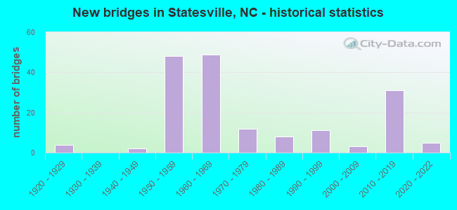
- New bridges - historical statistics
- 41920-1929
- 21940-1949
- 481950-1959
- 491960-1969
- 121970-1979
- 81980-1989
- 111990-1999
- 32000-2009
- 312010-2019
- 52020-2022
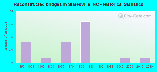
- Reconstructed bridges - Historical Statistics
- 41950-1959
- 11960-1969
- 41970-1979
- 81980-1989
- 01990-1999
- 12000-2009
- 12010-2019
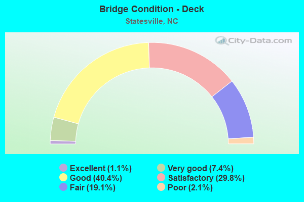
- Bridge Condition - Deck
- 1.1%Excellent
- 7.4%Very good
- 40.4%Good
- 29.8%Satisfactory
- 19.1%Fair
- 2.1%Poor
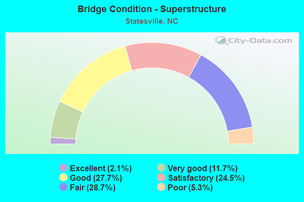
- Bridge Condition - Superstructure
- 2.1%Excellent
- 11.7%Very good
- 27.7%Good
- 24.5%Satisfactory
- 28.7%Fair
- 5.3%Poor
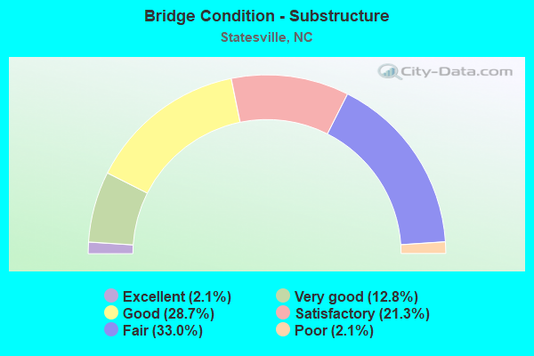
- Bridge Condition - Substructure
- 2.1%Excellent
- 12.8%Very good
- 28.7%Good
- 21.3%Satisfactory
- 33.0%Fair
- 2.1%Poor
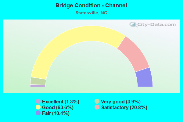
- Bridge Condition - Channel
- 1.3%Excellent
- 3.9%Very good
- 63.6%Good
- 20.8%Satisfactory
- 10.4%Fair
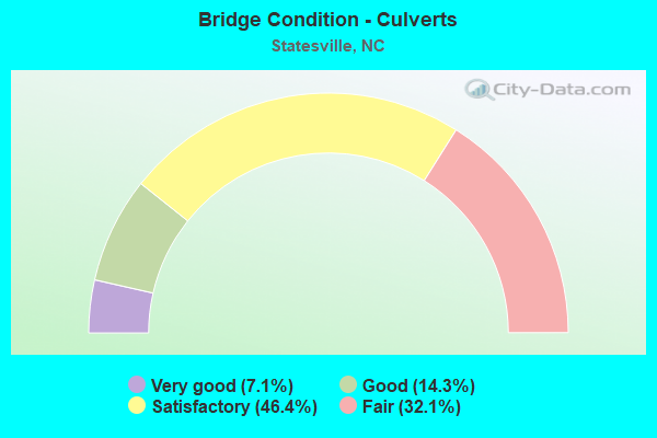
- Bridge Condition - Culverts
- 7.1%Very good
- 14.3%Good
- 46.4%Satisfactory
- 32.1%Fair
Find on map >> Show street view
Structure Number: 970109, Location: 1.8 MI. W. OF NC 115 (Lat: 35.793908, Lng: -80.936200), Route carried "under" structure: US 64, Year Built: 1953, Structure Length: 0. m, Average Daily Traffic: 10,750 (year 2019), Truck Traffic: 12%, Features Intersected: I40 WBL
Minimum Vertical Clearance: 5.10m (16.73ft), Kilometerpoint: 45.098, Lanes on structure: 3, Lanes under structure: 3, Material/Design: Steel, Design/Construction: Stringer/Multi-beam, Length of Maximum Span: 21.0m (68.9ft)
Find on map >> Show street view
Structure Number: 970109, Location: 1.8 MI. W. OF NC 115 (Lat: 35.793908, Lng: -80.936200), Route carried "under" structure: US 64, Year Built: 1953, Structure Length: 0. m, Average Daily Traffic: 10,750 (year 2019), Truck Traffic: 12%, Features Intersected: I40 WBL
Minimum Vertical Clearance: 5.18m (16.99ft), Kilometerpoint: 45.098, Lanes on structure: 3, Lanes under structure: 2, Material/Design: Steel, Design/Construction: Stringer/Multi-beam, Length of Maximum Span: 21.0m (68.9ft)
Find on map >> Show street view
Structure Number: 970118, Location: 300FT. N. JCT. SR1621 (Lat: 35.797361, Lng: -80.921750), Route carried "under" structure: Interstate 40, Year Built: 1960, Structure Length: 0. m, Average Daily Traffic: 24,000 (year 2013), Truck Traffic: 16%, Features Intersected: SR1639
Minimum Vertical Clearance: 4.64m (15.22ft), Kilometerpoint: 45.351, Lanes on structure: 2, Lanes under structure: 2, Material/Design: Steel, Design/Construction: Stringer/Multi-beam, Length of Maximum Span: 16.4m (53.8ft)
Find on map >> Show street view
Structure Number: 970118, Location: 300FT. N. JCT. SR1621 (Lat: 35.797361, Lng: -80.921750), Route carried "under" structure: Interstate 40, Year Built: 1960, Structure Length: 0. m, Average Daily Traffic: 24,000 (year 2013), Truck Traffic: 12%, Features Intersected: SR1639
Minimum Vertical Clearance: 4.71m (15.45ft), Kilometerpoint: 45.351, Lanes on structure: 2, Lanes under structure: 2, Material/Design: Steel, Design/Construction: Stringer/Multi-beam, Length of Maximum Span: 16.4m (53.8ft)
Find on map >> Show street view
Structure Number: 970123, Location: 1.8 MI. E. OF US64/90 (Lat: 35.801536, Lng: -80.905219), Route carried "under" structure: State highway 115, Year Built: 1960, Structure Length: 0. m, Average Daily Traffic: 17,500 (year 2019), Truck Traffic: 6%, Features Intersected: I-40 EBL
Minimum Vertical Clearance: 4.39m (14.40ft), Kilometerpoint: 45.647, Lanes on structure: 2, Lanes under structure: 3, Material/Design: Steel, Design/Construction: Stringer/Multi-beam, Length of Maximum Span: 14.6m (47.9ft)
Find on map >> Show street view
Structure Number: 970124, Location: 0.9 MI. W. JCT. SR 2003 (Lat: 35.801664, Lng: -80.905364), Route carried "under" structure: State highway 115, Year Built: 1953, Structure Length: 0. m, Average Daily Traffic: 18,500 (year 2018), Truck Traffic: 6%, Features Intersected: I40 WBL
Minimum Vertical Clearance: 4.39m (14.40ft), Kilometerpoint: 45.647, Lanes on structure: 2, Lanes under structure: 3, Material/Design: Concrete, Design/Construction: Tee Beam, Length of Maximum Span: 14.9m (48.9ft)
Find on map >> Show street view
Structure Number: 970126, Location: 0.3 MI. S. JCT. SR2350 (Lat: 35.725444, Lng: -80.857844), Route carried "under" structure: Interstate 77, Year Built: 1957, Structure Length: 0. m, Average Daily Traffic: 27,500 (year 2015), Truck Traffic: 16%, Features Intersected: SR2342
Minimum Vertical Clearance: 5.18m (16.99ft), Kilometerpoint: 13.822, Lanes on structure: 2, Lanes under structure: 2, Material/Design: Steel, Design/Construction: Stringer/Multi-beam, Length of Maximum Span: 21.0m (68.9ft)
Find on map >> Show street view
Structure Number: 970126, Location: 0.3 MI. S. JCT. SR2350 (Lat: 35.725444, Lng: -80.857844), Route carried "under" structure: Interstate 77, Year Built: 1957, Structure Length: 0. m, Average Daily Traffic: 27,500 (year 2015), Truck Traffic: 16%, Features Intersected: SR2342
Minimum Vertical Clearance: 5.03m (16.50ft), Kilometerpoint: 13.822, Lanes on structure: 2, Lanes under structure: 2, Material/Design: Steel, Design/Construction: Stringer/Multi-beam, Length of Maximum Span: 21.0m (68.9ft)
Find on map >> Show street view
Structure Number: 970127, Location: 0.9 MI. N. JCT. SR2342 (Lat: 35.737344, Lng: -80.859181), Route carried "under" structure: State highway 2435, Year Built: 1974, Structure Length: 0. m, Average Daily Traffic: 20 (year 2008), Truck Traffic: 7%, Features Intersected: I77
Minimum Vertical Clearance: 3.63m (11.91ft), Kilometerpoint: 0.000, Lanes on structure: 4, Lanes under structure: 1, Material/Design: Concrete, Design/Construction: Culvert, Length of Maximum Span: 4.2m (13.8ft)
Find on map >> Show street view
Structure Number: 970134, Location: 0.1M. S. JCT. SR1931 (Lat: 35.805161, Lng: -80.890289), Route carried "under" structure: Interstate 40, Year Built: 2013, Structure Length: 0. m, Average Daily Traffic: 30,500 (year 2018), Truck Traffic: 16%, Features Intersected: RADIO RD.
Minimum Vertical Clearance: 5.94m (19.49ft), Kilometerpoint: 0.000, Lanes on structure: 2, Lanes under structure: 2, Material/Design: Prestressed concrete, Design/Construction: Stringer/Multi-beam, Length of Maximum Span: 34.1m (111.9ft)
Find on map >> Show street view
Structure Number: 970134, Location: 0.1M. S. JCT. SR1931 (Lat: 35.805161, Lng: -80.890289), Route carried "under" structure: Interstate 40, Year Built: 2013, Structure Length: 0. m, Average Daily Traffic: 30,500 (year 2018), Truck Traffic: 16%, Features Intersected: RADIO RD.
Minimum Vertical Clearance: 5.48m (17.98ft), Kilometerpoint: 0.000, Lanes on structure: 2, Lanes under structure: 2, Material/Design: Prestressed concrete, Design/Construction: Stringer/Multi-beam, Length of Maximum Span: 34.1m (111.9ft)
Find on map >> Show street view
Structure Number: 970138, Location: 0.2 MI. S. JCT. SR2735 (Lat: 35.772514, Lng: -80.863036), Route carried "under" structure: US 70, Year Built: 1957, Structure Length: 0. m, Average Daily Traffic: 1,400 (year 2013), Truck Traffic: 12%, Features Intersected: I77 NBL
Minimum Vertical Clearance: 4.62m (15.16ft), Kilometerpoint: 0.000, Lanes on structure: 3, Lanes under structure: 4, Material/Design: Concrete, Design/Construction: Tee Beam, Length of Maximum Span: 17.3m (56.8ft)
Find on map >> Show street view
Structure Number: 970139, Location: 0.2 MI. S. JCT. SR2735 (Lat: 35.772572, Lng: -80.863267), Route carried "under" structure: US 70, Year Built: 1957, Structure Length: 0. m, Average Daily Traffic: 14,000 (year 2013), Truck Traffic: 12%, Features Intersected: I77 SBL
Minimum Vertical Clearance: 5.65m (18.54ft), Kilometerpoint: 0.000, Lanes on structure: 3, Lanes under structure: 4, Material/Design: Concrete, Design/Construction: Tee Beam, Length of Maximum Span: 17.3m (56.8ft)
Find on map >> Show street view
Structure Number: 970149, Location: 0.2 MI. N. JCT.US70 (Lat: 35.774769, Lng: -80.863283), Route carried "under" structure: State highway 2735, Year Built: 1957, Structure Length: 0. m, Average Daily Traffic: 15,000 (year 2013), Truck Traffic: 6%, Features Intersected: I77 NBL
Minimum Vertical Clearance: 4.57m (14.99ft), Kilometerpoint: 0.000, Lanes on structure: 3, Lanes under structure: 4, Material/Design: Concrete, Design/Construction: Tee Beam, Length of Maximum Span: 15.8m (51.8ft)
Find on map >> Show street view
Structure Number: 970151, Location: 0.2 MI. N. JCT. US70 (Lat: 35.774800, Lng: -80.863508), Route carried "under" structure: State highway 2735, Year Built: 1957, Structure Length: 0. m, Average Daily Traffic: 18,000 (year 2017), Truck Traffic: 6%, Features Intersected: I77 SBL
Minimum Vertical Clearance: 4.69m (15.39ft), Kilometerpoint: 0.000, Lanes on structure: 3, Lanes under structure: 4, Material/Design: Concrete, Design/Construction: Tee Beam, Length of Maximum Span: 15.8m (51.8ft)
Find on map >> Show street view
Structure Number: 970154, Location: 1.1 MI. E. JCT. US70 (Lat: 35.791178, Lng: -80.862461), Route carried "under" structure: Interstate 77, Year Built: 1957, Structure Length: 0. m, Average Daily Traffic: 31,750 (year 2013), Truck Traffic: 16%, Features Intersected: SR2321
Minimum Vertical Clearance: 5.04m (16.54ft), Kilometerpoint: 15.206, Lanes on structure: 5, Lanes under structure: 3, Material/Design: Concrete, Design/Construction: Tee Beam, Length of Maximum Span: 17.3m (56.8ft)
Find on map >> Show street view
Structure Number: 970154, Location: 1.1 MI. E. JCT. US70 (Lat: 35.791178, Lng: -80.862461), Route carried "under" structure: Interstate 77, Year Built: 1957, Structure Length: 0. m, Average Daily Traffic: 31,750 (year 2013), Truck Traffic: 16%, Features Intersected: SR2321
Minimum Vertical Clearance: 4.99m (16.37ft), Kilometerpoint: 15.206, Lanes on structure: 5, Lanes under structure: 3, Material/Design: Concrete, Design/Construction: Tee Beam, Length of Maximum Span: 17.3m (56.8ft)
Find on map >> Show street view
Structure Number: 970163, Location: 0.2 MI. N. JCT. US64 (Lat: 35.814650, Lng: -80.831528), Route carried "under" structure: State highway 2158, Year Built: 1969, Structure Length: 0. m, Average Daily Traffic: 7,000 (year 2012), Truck Traffic: 7%, Features Intersected: I40 EBL
Minimum Vertical Clearance: 4.82m (15.81ft), Kilometerpoint: 0.000, Lanes on structure: 2, Lanes under structure: 2, Material/Design: Steel, Design/Construction: Stringer/Multi-beam, Length of Maximum Span: 15.8m (51.8ft)
Find on map >> Show street view
Structure Number: 970163, Location: 0.2 MI. N. JCT. US64 (Lat: 35.814650, Lng: -80.831528), Route carried "under" structure: State highway 2158, Year Built: 1969, Structure Length: 0. m, Average Daily Traffic: 7,000 (year 2012), Truck Traffic: 7%, Features Intersected: I40 EBL
Minimum Vertical Clearance: 4.77m (15.65ft), Kilometerpoint: 0.000, Lanes on structure: 2, Lanes under structure: 2, Material/Design: Steel, Design/Construction: Stringer/Multi-beam, Length of Maximum Span: 15.8m (51.8ft)
Find on map >> Show street view
Structure Number: 970168, Location: 0.2 MI. E. JCT. US64 (Lat: 35.814889, Lng: -80.831483), Route carried "under" structure: State highway 2158, Year Built: 1969, Structure Length: 0. m, Average Daily Traffic: 7,000 (year 2012), Truck Traffic: 7%, Features Intersected: I40 WBL
Minimum Vertical Clearance: 5.30m (17.39ft), Kilometerpoint: 0.000, Lanes on structure: 2, Lanes under structure: 2, Material/Design: Steel, Design/Construction: Stringer/Multi-beam, Length of Maximum Span: 15.8m (51.8ft)
Find on map >> Show street view
Structure Number: 970168, Location: 0.2 MI. E. JCT. US64 (Lat: 35.814889, Lng: -80.831483), Route carried "under" structure: State highway 2158, Year Built: 1969, Structure Length: 0. m, Average Daily Traffic: 7,000 (year 2012), Truck Traffic: 7%, Features Intersected: I40 WBL
Minimum Vertical Clearance: 5.33m (17.49ft), Kilometerpoint: 0.000, Lanes on structure: 2, Lanes under structure: 2, Material/Design: Steel, Design/Construction: Stringer/Multi-beam, Length of Maximum Span: 15.8m (51.8ft)
Find on map >> Show street view
Structure Number: 97017, Location: 1.3 MI. N. JCT. E. BROAD (Lat: 35.809681, Lng: -80.861275), Route carried "under" structure: Interstate 40, Year Built: 1957, Structure Length: 0. m, Average Daily Traffic: 25,250 (year 2013), Truck Traffic: 16%, Features Intersected: I77 SBL
Minimum Vertical Clearance: 5.69m (18.67ft), Kilometerpoint: 46.424, Lanes on structure: 3, Lanes under structure: 3, Material/Design: Steel, Design/Construction: Stringer/Multi-beam, Length of Maximum Span: 20.1m (65.9ft)
Find on map >> Show street view
Structure Number: 97017, Location: 1.3 MI. N. JCT. E. BROAD (Lat: 35.809681, Lng: -80.861275), Route carried "under" structure: Interstate 40, Year Built: 1957, Structure Length: 0. m, Average Daily Traffic: 25,250 (year 2013), Truck Traffic: 16%, Features Intersected: I77 SBL
Minimum Vertical Clearance: 4.77m (15.65ft), Kilometerpoint: 46.424, Lanes on structure: 3, Lanes under structure: 3, Material/Design: Steel, Design/Construction: Stringer/Multi-beam, Length of Maximum Span: 20.1m (65.9ft)
Find on map >> Show street view
Structure Number: 970171, Location: 0.4 MI.S.JCT.SR2169 (Lat: 35.830539, Lng: -80.787731), Route carried "under" structure: Interstate 40, Year Built: 1969, Structure Length: 0. m, Average Daily Traffic: 18,000 (year 2015), Truck Traffic: 23%, Features Intersected: SR2166
Minimum Vertical Clearance: 5.15m (16.90ft), Kilometerpoint: 47.765, Lanes on structure: 2, Lanes under structure: 2, Material/Design: Steel, Design/Construction: Stringer/Multi-beam, Length of Maximum Span: 26.2m (86.0ft)
Find on map >> Show street view
Structure Number: 970171, Location: 0.4 MI.S.JCT.SR2169 (Lat: 35.830539, Lng: -80.787731), Route carried "under" structure: Interstate 40, Year Built: 1969, Structure Length: 0. m, Average Daily Traffic: 18,000 (year 2015), Truck Traffic: 23%, Features Intersected: SR2166
Minimum Vertical Clearance: 5.62m (18.44ft), Kilometerpoint: 47.765, Lanes on structure: 2, Lanes under structure: 2, Material/Design: Steel, Design/Construction: Stringer/Multi-beam, Length of Maximum Span: 26.2m (86.0ft)
Find on map >> Show street view
Structure Number: 970181, Location: 0.2 MI. S. JCT. SR2166 (Lat: 35.847281, Lng: -80.769289), Route carried "under" structure: Interstate 40, Year Built: 1969, Structure Length: 0. m, Average Daily Traffic: 16,000 (year 2013), Truck Traffic: 23%, Features Intersected: SR2167
Minimum Vertical Clearance: 5.61m (18.41ft), Kilometerpoint: 48.238, Lanes on structure: 2, Lanes under structure: 2, Material/Design: Steel, Design/Construction: Stringer/Multi-beam, Length of Maximum Span: 21.3m (69.9ft)
Find on map >> Show street view
Structure Number: 970182, Location: 0.2 MI. W. JCT. SR2172 (Lat: 35.833661, Lng: -80.859747), Route carried "under" structure: Interstate 77, Year Built: 1964, Structure Length: 0. m, Average Daily Traffic: 19,000 (year 2013), Truck Traffic: 16%, Features Intersected: SR2171
Minimum Vertical Clearance: 5.10m (16.73ft), Kilometerpoint: 16.099, Lanes on structure: 2, Lanes under structure: 2, Material/Design: Steel, Design/Construction: Stringer/Multi-beam, Length of Maximum Span: 16.7m (54.8ft)
Find on map >> Show street view
Structure Number: 970182, Location: 0.2 MI. W. JCT. SR2172 (Lat: 35.833661, Lng: -80.859747), Route carried "under" structure: Interstate 77, Year Built: 1964, Structure Length: 0. m, Average Daily Traffic: 19,000 (year 2013), Truck Traffic: 16%, Features Intersected: SR2171
Minimum Vertical Clearance: 5.05m (16.57ft), Kilometerpoint: 16.099, Lanes on structure: 2, Lanes under structure: 2, Material/Design: Steel, Design/Construction: Stringer/Multi-beam, Length of Maximum Span: 16.7m (54.8ft)
Find on map >> Show street view
Structure Number: 97019, Location: 0.1 MI. W. JCT. SR1914 (Lat: 35.869142, Lng: -80.865100), Route carried "under" structure: Interstate 77, Year Built: 1973, Structure Length: 0. m, Average Daily Traffic: 18,750 (year 2018), Truck Traffic: 23%, Features Intersected: SR1892
Minimum Vertical Clearance: 5.09m (16.70ft), Kilometerpoint: 16.864, Lanes on structure: 2, Lanes under structure: 2, Material/Design: Steel continuous, Design/Construction: Stringer/Multi-beam, Length of Maximum Span: 32.0m (105.0ft)
Find on map >> Show street view
Structure Number: 97019, Location: 0.1 MI. W. JCT. SR1914 (Lat: 35.869142, Lng: -80.865100), Route carried "under" structure: Interstate 77, Year Built: 1973, Structure Length: 0. m, Average Daily Traffic: 18,750 (year 2018), Truck Traffic: 23%, Features Intersected: SR1892
Minimum Vertical Clearance: 5.03m (16.50ft), Kilometerpoint: 16.864, Lanes on structure: 2, Lanes under structure: 2, Material/Design: Steel continuous, Design/Construction: Stringer/Multi-beam, Length of Maximum Span: 32.0m (105.0ft)
Find on map >> Show street view
Structure Number: 970513, Location: 0.05 MI. S. JCT. SR1420 (Lat: 35.774683, Lng: -80.890550), Route carried "under" structure: City street , Year Built: 2011, Structure Length: 0. m, Average Daily Traffic: 200 (year 2012), Truck Traffic: 7%, Features Intersected: SR1421, Facility Carried by Structure: EAST WISE STREET
Minimum Vertical Clearance: 5.01m (16.44ft), Kilometerpoint: 0.000, Lanes on structure: 2, Lanes under structure: 2, Material/Design: Steel continuous, Design/Construction: Stringer/Multi-beam, Length of Maximum Span: 26.5m (86.9ft)
Find on map >> Show street view
Structure Number: 970556, Location: 1.1 MI. E. JCT. SR2359 (Lat: 35.752475, Lng: -80.792269), Route carried "under" structure: State highway 2527, Year Built: 2010, Structure Length: 0. m, Average Daily Traffic: 200 (year 2000), Truck Traffic: 6%, Features Intersected: US70 WBL
Minimum Vertical Clearance: 8.02m (26.31ft), Kilometerpoint: 0.000, Lanes on structure: 2, Lanes under structure: 2, Material/Design: Steel, Design/Construction: Stringer/Multi-beam, Length of Maximum Span: 38.1m (125.0ft)
Find on map >> Show street view
Structure Number: 970557, Location: 1.1 MI. E. JCT. SR2359 (Lat: 35.752306, Lng: -80.792269), Route carried "under" structure: State highway 2527, Year Built: 2010, Structure Length: 0. m, Average Daily Traffic: 200 (year 2000), Truck Traffic: 6%, Features Intersected: US70 EBL
Minimum Vertical Clearance: 8.02m (26.31ft), Kilometerpoint: 0.000, Lanes on structure: 2, Lanes under structure: 2, Material/Design: Steel, Design/Construction: Stringer/Multi-beam, Length of Maximum Span: 37.7m (123.7ft)
Find on map >> Show street view
Structure Number: 970563, Location: .9 MI.W.JCT.I-77 (Lat: 35.807394, Lng: -80.876022), Route carried "under" structure: US 21, Year Built: 2014, Structure Length: 0. m, Average Daily Traffic: 8,750 (year 2018), Truck Traffic: 6%, Features Intersected: I-40
Minimum Vertical Clearance: 7.08m (23.23ft), Kilometerpoint: 46.177, Lanes on structure: 4, Lanes under structure: 3, Material/Design: Steel, Design/Construction: Stringer/Multi-beam, Length of Maximum Span: 47.2m (154.9ft)
Find on map >> Show street view
Structure Number: 970563, Location: .9 MI.W.JCT.I-77 (Lat: 35.807394, Lng: -80.876022), Route carried "under" structure: US 21, Year Built: 2014, Structure Length: 0. m, Average Daily Traffic: 8,750 (year 2018), Truck Traffic: 6%, Features Intersected: I-40
Minimum Vertical Clearance: 6.06m (19.88ft), Kilometerpoint: 46.177, Lanes on structure: 4, Lanes under structure: 2, Material/Design: Steel, Design/Construction: Stringer/Multi-beam, Length of Maximum Span: 47.2m (154.9ft)
Find on map >> Show street view
Structure Number: 970568, Location: 0.15 MI. N. JCT. I-40 (Lat: 35.812072, Lng: -80.860933), Route carried "under" structure: Ramp Interstate 40, Year Built: 2014, Structure Length: 0. m, Average Daily Traffic: 11,750 (year 2015), Truck Traffic: 16%, Features Intersected: I-77
Minimum Vertical Clearance: 6.06m (19.88ft), Kilometerpoint: 0.000, Lanes on structure: 2, Lanes under structure: 2, Material/Design: Prestressed concrete, Design/Construction: Stringer/Multi-beam, Length of Maximum Span: 35.9m (117.8ft)
Find on map >> Show street view
Structure Number: 970569, Location: 0.2 MI. E. JCT. I-77 (Lat: 35.810356, Lng: -80.858231), Route carried "under" structure: Ramp Interstate 40, Year Built: 2015, Structure Length: 0. m, Average Daily Traffic: 11,750 (year 2015), Truck Traffic: 16%, Features Intersected: I-40 W
Minimum Vertical Clearance: 6.37m (20.90ft), Kilometerpoint: 0.000, Lanes on structure: 2, Lanes under structure: 1, Material/Design: Prestressed concrete, Design/Construction: Stringer/Multi-beam, Length of Maximum Span: 33.8m (110.9ft)
Find on map >> Show street view
Structure Number: 97057, Location: 0.2 MI. E. JCT. I77 (Lat: 35.810150, Lng: -80.858133), Route carried "under" structure: Ramp Interstate 40, Year Built: 2016, Structure Length: 0. m, Average Daily Traffic: 8,125 (year 2017), Truck Traffic: 16%, Features Intersected: I40E
Minimum Vertical Clearance: 6.57m (21.56ft), Kilometerpoint: 0.000, Lanes on structure: 2, Lanes under structure: 1, Material/Design: Prestressed concrete, Design/Construction: Stringer/Multi-beam, Length of Maximum Span: 32.6m (107.0ft)