Bridge Statistics for Sylacauga, Alabama (AL)
Condition, Traffic, Stress, Structural Evaluation, Project Costs
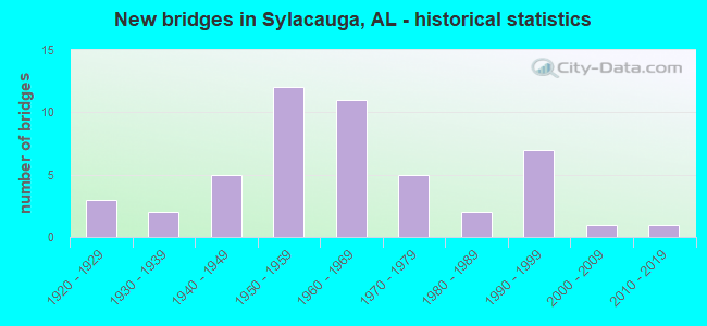
- New bridges - historical statistics
- 31920-1929
- 21930-1939
- 51940-1949
- 121950-1959
- 111960-1969
- 51970-1979
- 21980-1989
- 71990-1999
- 12000-2009
- 12010-2019
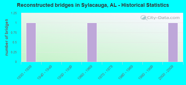
- Reconstructed bridges - Historical Statistics
- 11930-1939
- 01940-1949
- 01950-1959
- 11960-1969
- 01970-1979
- 01980-1989
- 01990-1999
- 12000-2009
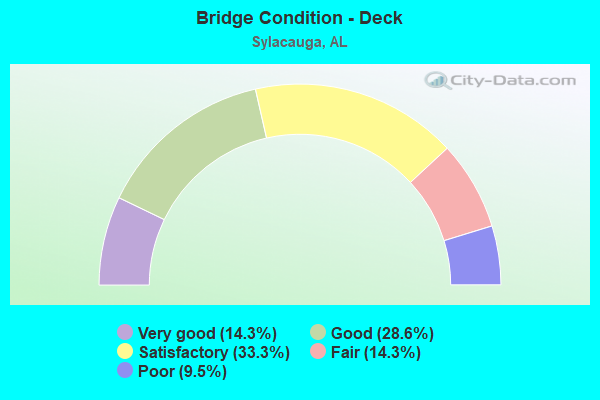
- Bridge Condition - Deck
- 14.3%Very good
- 28.6%Good
- 33.3%Satisfactory
- 14.3%Fair
- 9.5%Poor
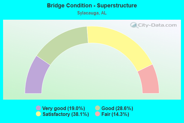
- Bridge Condition - Superstructure
- 19.0%Very good
- 28.6%Good
- 38.1%Satisfactory
- 14.3%Fair
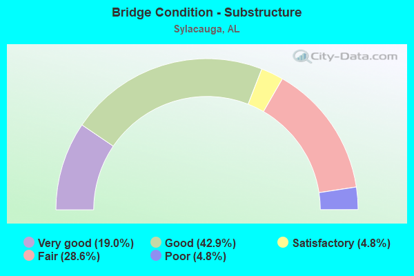
- Bridge Condition - Substructure
- 19.0%Very good
- 42.9%Good
- 4.8%Satisfactory
- 28.6%Fair
- 4.8%Poor
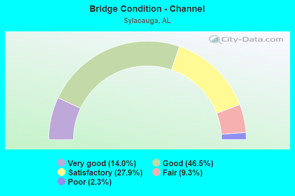
- Bridge Condition - Channel
- 14.0%Very good
- 46.5%Good
- 27.9%Satisfactory
- 9.3%Fair
- 2.3%Poor
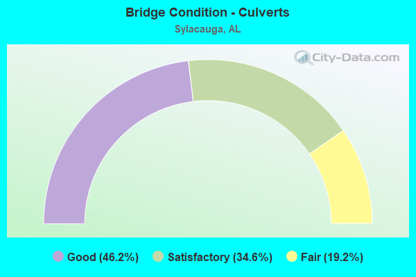
- Bridge Condition - Culverts
- 46.2%Good
- 34.6%Satisfactory
- 19.2%Fair
Find on map >> Show street view
Structure Number: 264, Location: SYLACAUGA (Lat: 33.203800, Lng: -86.205000), Route carried "on" structure: City street , Year Built: 1925, Status: Posted for load, Structure Length: 1.46m (4.79ft), Average Daily Traffic: 150 (year 2022), Truck Traffic: 1%, Average Future Daily Traffic: 195 (year 2042), Design Load: H 15, Features Intersected: CROOKED CREEK, Facility Carried by Structure: CO. ROAD 132
Minimum Vertical Clearance: 30+ m (98+ ft), Kilometerpoint: 2.699, Lanes on structure: 1, Owner: City or Municipal Highway Agency, Approaching Roadway Width: 3.8m (12.5ft), Material/Design: Concrete continuous, Design/Construction: Slab, Number Of Spans In Main Unit: 3, Length of Maximum Span: 4.9m (16.1ft), Curb or Sidewalk Widths: Left: 0.1m (0.3ft), Right: 0.1m (0.3ft), Curb-To-Curb Width: 4.2m (13.8ft), Out-to-Out Width: 4.6m (15.1ft)
Condition: Deck: Poor, Superstructure: Fair, Substructure: Fair, Channel: Fair, Operating Rating: 13.6 metric tons, Method Used To Determine Operating Rating: Field evaluation and documented engineering judgment, Inventory Rating: 10.0 metric tons, Method Used To Determine Inventory Rating: Field evaluation and documented engineering judgment, Structural Evaluation: High priority of replacement, Deck Geometry: High priority of replacement, Waterway Adequacy: Equal to present minimum criteria, Approach Roadway Alignment: Better than present minimum criteria, Bridge Posting: Required (Relationship of Operating Rating to Maximum Legal Load: > 39.9% below), Length Of Structure Improvement: 2.14m (7.02ft), Designated Inspection Frequency: Every 24 months, Other Special Inspection Frequency: Every 12 months, Inspection Date: Febuary 2022, Other Special Inspection Date: Febuary 2022, Bridge Improvement Cost: $220,000, Roadway Improvement Cost: $22,000, Total Project Cost: $242,000 ( Estimate for 2022), Deck Structure Type: Concrete Cast-file-Place
Find on map >> Show street view
Structure Number: 387, Location: 3 MI. E. OF CAMDEN (Lat: 31.986589, Lng: -87.228542), Route carried "on" structure: State highway 10, Year Built: 1927, Status: Open, Structure Length: 0.68m (2.23ft), Average Daily Traffic: 2,940 (year 2013), Truck Traffic: 15%, Average Future Daily Traffic: 3,829 (year 2033), Design Load: H 15, Features Intersected: BRANCH
Minimum Vertical Clearance: 30+ m (98+ ft), Kilometerpoint: 132.467, Lanes on structure: 2, Owner: State Highway Agency, Approaching Roadway Width: 9.4m (30.8ft), Material/Design: Concrete, Design/Construction: Culvert, Number Of Spans In Main Unit: 2, Length of Maximum Span: 3.0m (9.8ft)
Condition: Channel: Satisfactory, Culverts: Satisfactory, Operating Rating: 45.5 metric tons, Method Used To Determine Operating Rating: Load Factor (LF), Inventory Rating: 27.3 metric tons, Method Used To Determine Inventory Rating: Load Factor (LF), Structural Evaluation: Equal to present minimum criteria, Waterway Adequacy: Better than present minimum criteria, Approach Roadway Alignment: Equal to present desirable criteria, Length Of Structure Improvement: 1.31m (4.30ft), Designated Inspection Frequency: Every 24 months, Inspection Date: May 2021, Bridge Improvement Cost: $204,000, Roadway Improvement Cost: $20,000, Total Project Cost: $224,000 ( Estimate for 2022)
Find on map >> Show street view
Structure Number: 85, Location: 05 MI E CO 105 (Lat: 33.256558, Lng: -86.248619), Route carried "on" structure: County highway 177, Year Built: 1930, Status: Posted for load, Structure Length: 0.91m (2.99ft), Average Daily Traffic: 480 (year 2018), Average Future Daily Traffic: 580 (year 2038), Design Load: H 10, Features Intersected: BRANCH
Minimum Vertical Clearance: 30+ m (98+ ft), Kilometerpoint: 0.010, Lanes on structure: 2, Owner: County Highway Agency, Approaching Roadway Width: 8.5m (27.9ft), Material/Design: Steel, Design/Construction: Stringer/Multi-beam, Number Of Spans In Main Unit: 1, Length of Maximum Span: 9.1m (29.9ft), Curb-To-Curb Width: 7.3m (24.0ft), Out-to-Out Width: 7.3m (24.0ft)
Condition: Deck: Very good, Superstructure: Satisfactory, Substructure: Good, Channel: Very good, Operating Rating: 24.5 metric tons, Method Used To Determine Operating Rating: Allowable Stress (AS), Inventory Rating: 18.3 metric tons, Method Used To Determine Inventory Rating: Allowable Stress (AS), Structural Evaluation: Somewhat better than minimum adequacy, Deck Geometry: Meets minimum limits, Waterway Adequacy: Meets minimum limits, Approach Roadway Alignment: Somewhat better than minimum adequacy, Bridge Posting: Required (Relationship of Operating Rating to Maximum Legal Load: 30.0 - 39.9% below), Length Of Structure Improvement: 1.58m (5.18ft), Designated Inspection Frequency: Every 24 months, Other Special Inspection Frequency: Every 12 months, Inspection Date: July 2020, Other Special Inspection Date: July 2021, Bridge Improvement Cost: $260,000, Roadway Improvement Cost: $26,000, Total Project Cost: $286,000 ( Estimate for 2022), Deck Structure Type: Wood or Timber, Wearing Surface/Protective System: Wearing Surface: Wood or Timber
Find on map >> Show street view
Structure Number: 1818, Location: Sulligent (Lat: 33.895250, Lng: -88.146750), Route carried "on" structure: US 278, Year Built: 1928, Year Reconstructed: 1938, Status: Open, Structure Length: 2.35m (7.71ft), Average Daily Traffic: 4,850 (year 2020), Truck Traffic: 17%, Average Future Daily Traffic: 6,675 (year 2038), Design Load: H 15, Features Intersected: Bogue Creek, Facility Carried by Structure: AL-118
Minimum Vertical Clearance: 30+ m (98+ ft), Kilometerpoint: 7.895, Lanes on structure: 2, Base Highway Network: Yes, Owner: State Highway Agency, Approaching Roadway Width: 9.8m (32.2ft), Material/Design: Steel continuous, Design/Construction: Stringer/Multi-beam, Number Of Spans In Main Unit: 4, Length of Maximum Span: 5.8m (19.0ft), Curb or Sidewalk Widths: Left: 0.2m (0.7ft), Right: 0.2m (0.7ft), Curb-To-Curb Width: 7.3m (24.0ft), Out-to-Out Width: 8.3m (27.2ft)
Condition: Deck: Fair, Superstructure: Satisfactory, Substructure: Fair, Channel: Satisfactory, Operating Rating: 61.4 metric tons, Method Used To Determine Operating Rating: Load Factor (LF), Inventory Rating: 36.7 metric tons, Method Used To Determine Inventory Rating: Load Factor (LF), Structural Evaluation: Somewhat better than minimum adequacy, Deck Geometry: High priority of replacement, Waterway Adequacy: Equal to present minimum criteria, Approach Roadway Alignment: Equal to present minimum criteria, Length Of Structure Improvement: 3.19m (10.47ft), Designated Inspection Frequency: Every 24 months, Inspection Date: November 2020, Bridge Improvement Cost: $591,000, Roadway Improvement Cost: $59,000, Total Project Cost: $650,000 ( Estimate for 2022), Deck Structure Type: Concrete Cast-file-Place
Find on map >> Show street view
Structure Number: 2045, Location: 0.8 MI N US HWY 72 (Lat: 34.767839, Lng: -86.714200), Route carried "on" structure: County highway 88, Year Built: 1939, Status: Posted for load, Structure Length: 1.28m (4.20ft), Average Daily Traffic: 3,500 (year 1992), Truck Traffic: 1%, Average Future Daily Traffic: 5,300 (year 2035), Design Load: H 15, Features Intersected: VAUGHN BRANCH, Facility Carried by Structure: JEFF RD
Minimum Vertical Clearance: 30+ m (98+ ft), Kilometerpoint: 0.010, Lanes on structure: 2, Owner: County Highway Agency, Approaching Roadway Width: 6.1m (20.0ft), Material/Design: Concrete, Design/Construction: Culvert, Number Of Spans In Main Unit: 3, Length of Maximum Span: 4.3m (14.1ft), Curb-To-Curb Width: 8.0m (26.2ft), Out-to-Out Width: 8.5m (27.9ft)
Condition: Channel: Satisfactory, Culverts: Fair, Operating Rating: 20.0 metric tons, Method Used To Determine Operating Rating: Load Factor (LF), Inventory Rating: 12.0 metric tons, Method Used To Determine Inventory Rating: Load Factor (LF), Structural Evaluation: High priority of replacement, Deck Geometry: High priority of corrective action, Waterway Adequacy: Equal to present minimum criteria, Approach Roadway Alignment: Equal to present minimum criteria, Bridge Posting: Required (Relationship of Operating Rating to Maximum Legal Load: > 39.9% below), Length Of Structure Improvement: 1.95m (6.40ft), Designated Inspection Frequency: Every 24 months, Other Special Inspection Frequency: Every 12 months, Inspection Date: November 2020, Other Special Inspection Date: November 2021, Bridge Improvement Cost: $316,000, Roadway Improvement Cost: $32,000, Total Project Cost: $348,000 ( Estimate for 2022), Deck Structure Type: Concrete Cast-file-Place
Find on map >> Show street view
Structure Number: 2239, Location: SYLACAUGA (Lat: 33.166667, Lng: -86.266667), Route carried "on" structure: City street , Year Built: 1940, Status: Open, Structure Length: 1.03m (3.38ft), Average Daily Traffic: 4,200 (year 2021), Truck Traffic: 7%, Average Future Daily Traffic: 5,900 (year 2041), Design Load: H 15, Features Intersected: DARBY CREEK, Facility Carried by Structure: WEST FT. WILLIAMS
Minimum Vertical Clearance: 30+ m (98+ ft), Kilometerpoint: 0.999, Lanes on structure: 2, Owner: City or Municipal Highway Agency, Approaching Roadway Width: 14.0m (45.9ft), Skew: 1 degrees, Material/Design: Concrete, Design/Construction: Culvert, Number Of Spans In Main Unit: 3, Length of Maximum Span: 3.1m (10.2ft), Curb-To-Curb Width: 15.6m (51.2ft), Out-to-Out Width: 19.2m (63.0ft)
Condition: Channel: Satisfactory, Culverts: Satisfactory, Operating Rating: 67.2 metric tons, Method Used To Determine Operating Rating: Load Factor (LF), Inventory Rating: 40.3 metric tons, Method Used To Determine Inventory Rating: Load Factor (LF), Structural Evaluation: Equal to present minimum criteria, Deck Geometry: Superior to present desirable criteria, Waterway Adequacy: Equal to present minimum criteria, Approach Roadway Alignment: Equal to present desirable criteria, Length Of Structure Improvement: 1.70m (5.58ft), Designated Inspection Frequency: Every 24 months, Inspection Date: April 2021, Bridge Improvement Cost: $657,000, Roadway Improvement Cost: $66,000, Total Project Cost: $723,000 ( Estimate for 2022)
Find on map >> Show street view
Structure Number: 2416, Location: 0.9 MI E JCT CO 16 (Lat: 33.316292, Lng: -86.237733), Route carried "on" structure: State highway 76, Year Built: 1940, Status: Open, Structure Length: 0.69m (2.26ft), Average Daily Traffic: 2,509 (year 2019), Truck Traffic: 4%, Average Future Daily Traffic: 3,513 (year 2039), Design Load: H 15, Features Intersected: BRYANT BRANCH
Minimum Vertical Clearance: 30+ m (98+ ft), Kilometerpoint: 23.062, Lanes on structure: 2, Base Highway Network: Yes, Owner: State Highway Agency, Approaching Roadway Width: 8.5m (27.9ft), Skew: 4 degrees, Material/Design: Concrete, Design/Construction: Culvert, Number Of Spans In Main Unit: 3, Length of Maximum Span: 2.2m (7.2ft)
Condition: Channel: Good, Culverts: Satisfactory, Operating Rating: 69.9 metric tons, Method Used To Determine Operating Rating: Load Factor (LF), Inventory Rating: 42.3 metric tons, Method Used To Determine Inventory Rating: Load Factor (LF), Structural Evaluation: Equal to present minimum criteria, Waterway Adequacy: Equal to present minimum criteria, Approach Roadway Alignment: Equal to present desirable criteria, Length Of Structure Improvement: 1.33m (4.36ft), Designated Inspection Frequency: Every 24 months, Inspection Date: May 2021, Bridge Improvement Cost: $337,000, Roadway Improvement Cost: $34,000, Total Project Cost: $371,000 ( Estimate for 2022)
Find on map >> Show street view
Structure Number: 2417, Location: 0.5 MI E JCT CO 45 (Lat: 33.321722, Lng: -86.208111), Route carried "on" structure: State highway 76, Year Built: 1940, Status: Open, Structure Length: 1.61m (5.28ft), Average Daily Traffic: 2,509 (year 2019), Truck Traffic: 4%, Average Future Daily Traffic: 3,513 (year 2039), Design Load: H 15, Features Intersected: GREASY HEAD BRANCH
Minimum Vertical Clearance: 30+ m (98+ ft), Kilometerpoint: 25.669, Lanes on structure: 2, Base Highway Network: Yes, Owner: State Highway Agency, Approaching Roadway Width: 8.6m (28.2ft), Material/Design: Concrete, Design/Construction: Culvert, Number Of Spans In Main Unit: 5, Length of Maximum Span: 3.0m (9.8ft), Curb-To-Curb Width: 8.5m (27.9ft), Out-to-Out Width: 9.8m (32.2ft)
Condition: Channel: Satisfactory, Culverts: Satisfactory, Operating Rating: 43.5 metric tons, Method Used To Determine Operating Rating: Field evaluation and documented engineering judgment, Inventory Rating: 32.7 metric tons, Method Used To Determine Inventory Rating: Field evaluation and documented engineering judgment, Structural Evaluation: Equal to present minimum criteria, Deck Geometry: Meets minimum limits, Waterway Adequacy: Equal to present minimum criteria, Approach Roadway Alignment: Equal to present desirable criteria, Length Of Structure Improvement: 2.30m (7.55ft), Designated Inspection Frequency: Every 24 months, Inspection Date: May 2021, Bridge Improvement Cost: $425,000, Roadway Improvement Cost: $43,000, Total Project Cost: $468,000 ( Estimate for 2022)
Find on map >> Show street view
Structure Number: 2626, Location: 0.8 MI W CLAY *TALLLINE (Lat: 33.125000, Lng: -86.190000), Route carried "on" structure: County highway 511, Year Built: 1941, Status: Open, Structure Length: 1.22m (4.00ft), Average Daily Traffic: 1,290 (year 2018), Truck Traffic: 15%, Average Future Daily Traffic: 1,525 (year 2038), Features Intersected: SHELTON CREEK
Minimum Vertical Clearance: 30+ m (98+ ft), Kilometerpoint: 0.010, Lanes on structure: 2, Owner: County Highway Agency, Approaching Roadway Width: 8.5m (27.9ft), Material/Design: Concrete, Design/Construction: Culvert, Number Of Spans In Main Unit: 4, Length of Maximum Span: 3.0m (9.8ft)
Condition: Channel: Good, Culverts: Good, Operating Rating: 80.3 metric tons, Method Used To Determine Operating Rating: Load Factor (LF), Inventory Rating: 48.2 metric tons, Method Used To Determine Inventory Rating: Load Factor (LF), Structural Evaluation: Better than present minimum criteria, Waterway Adequacy: Better than present minimum criteria, Approach Roadway Alignment: Equal to present desirable criteria, Length Of Structure Improvement: 1.89m (6.20ft), Designated Inspection Frequency: Every 24 months, Inspection Date: May 2020, Bridge Improvement Cost: $459,000, Roadway Improvement Cost: $46,000, Total Project Cost: $505,000 ( Estimate for 2022), Wearing Surface/Protective System: Wearing Surface: Bituminous
Find on map >> Show street view
Structure Number: 345, Location: 0.3 MI W FT WILLIAM (Lat: 33.163333, Lng: -86.291667), Route carried "on" structure: County highway 34, Year Built: 1949, Year Reconstructed: 1969, Status: Open, Structure Length: 1.07m (3.51ft), Average Daily Traffic: 1,610 (year 2018), Truck Traffic: 24%, Average Future Daily Traffic: 1,975 (year 2038), Design Load: H 15, Features Intersected: BRANCH - COLBERT
Minimum Vertical Clearance: 30+ m (98+ ft), Kilometerpoint: 0.010, Lanes on structure: 2, Owner: County Highway Agency, Approaching Roadway Width: 8.5m (27.9ft), Material/Design: Concrete, Design/Construction: Culvert, Number Of Spans In Main Unit: 4, Length of Maximum Span: 3.0m (9.8ft)
Condition: Channel: Satisfactory, Culverts: Good, Operating Rating: 43.5 metric tons, Method Used To Determine Operating Rating: Load Factor (LF), Inventory Rating: 26.1 metric tons, Method Used To Determine Inventory Rating: Load Factor (LF), Structural Evaluation: Equal to present minimum criteria, Waterway Adequacy: Better than present minimum criteria, Approach Roadway Alignment: Better than present minimum criteria, Length Of Structure Improvement: 1.74m (5.71ft), Designated Inspection Frequency: Every 24 months, Inspection Date: Febuary 2022, Bridge Improvement Cost: $352,000, Roadway Improvement Cost: $35,000, Total Project Cost: $387,000 ( Estimate for 2022), Wearing Surface/Protective System: Wearing Surface: Bituminous
Find on map >> Show street view
Structure Number: 387, Location: 2.9 MI. N OF AL 21 (Lat: 33.213369, Lng: -86.195539), Route carried "on" structure: County highway 123, Year Built: 1950, Status: Posted for load, Structure Length: 9.33m (30.61ft), Average Daily Traffic: 805 (year 2018), Truck Traffic: 1%, Average Future Daily Traffic: 935 (year 2038), Design Load: H 15, Features Intersected: TALASSEEHATCHEE CREEK
Minimum Vertical Clearance: 30+ m (98+ ft), Kilometerpoint: 2.898, Lanes on structure: 2, Owner: County Highway Agency, Approaching Roadway Width: 7.9m (25.9ft), Material/Design: Concrete, Design/Construction: Tee Beam, Number Of Spans In Main Unit: 9, Length of Maximum Span: 10.4m (34.1ft), Curb or Sidewalk Widths: Left: 0.2m (0.7ft), Right: 0.2m (0.7ft), Curb-To-Curb Width: 6.7m (22.0ft), Out-to-Out Width: 7.3m (24.0ft)
Condition: Deck: Satisfactory, Superstructure: Satisfactory, Substructure: Good, Channel: Good, Operating Rating: 31.8 metric tons, Method Used To Determine Operating Rating: Load Factor (LF), Inventory Rating: 19.1 metric tons, Method Used To Determine Inventory Rating: Load Factor (LF), Structural Evaluation: Somewhat better than minimum adequacy, Deck Geometry: Meets minimum limits, Waterway Adequacy: Equal to present desirable criteria, Approach Roadway Alignment: Equal to present minimum criteria, Bridge Posting: Required (Relationship of Operating Rating to Maximum Legal Load: 10.0 - 19.9% below), Length Of Structure Improvement: 10.29m (33.76ft), Designated Inspection Frequency: Every 24 months, Other Special Inspection Frequency: Every 12 months, Inspection Date: May 2020, Other Special Inspection Date: May 2021, Bridge Improvement Cost: $1,693,000, Roadway Improvement Cost: $169,000, Total Project Cost: $1,862,000 ( Estimate for 2022), Deck Structure Type: Concrete Cast-file-Place, Wearing Surface/Protective System: Membrane: Built-up
Find on map >> Show street view
Structure Number: 3882, Location: 0.2 MI E CO RT 123 (Lat: 33.246439, Lng: -86.197592), Route carried "on" structure: County highway 149, Year Built: 1950, Status: Posted for load, Structure Length: 1.07m (3.51ft), Average Daily Traffic: 235 (year 2018), Average Future Daily Traffic: 320 (year 2038), Features Intersected: BRANCH
Minimum Vertical Clearance: 30+ m (98+ ft), Kilometerpoint: 0.010, Lanes on structure: 1, Owner: County Highway Agency, Approaching Roadway Width: 5.5m (18.0ft), Material/Design: Steel, Design/Construction: Stringer/Multi-beam, Number Of Spans In Main Unit: 1, Length of Maximum Span: 10.7m (35.1ft), Curb-To-Curb Width: 5.5m (18.0ft), Out-to-Out Width: 5.5m (18.0ft)
Condition: Deck: Satisfactory, Superstructure: Fair, Substructure: Fair, Channel: Good, Operating Rating: 26.1 metric tons, Method Used To Determine Operating Rating: Allowable Stress (AS), Inventory Rating: 19.6 metric tons, Method Used To Determine Inventory Rating: Allowable Stress (AS), Structural Evaluation: Somewhat better than minimum adequacy, Deck Geometry: High priority of corrective action, Waterway Adequacy: Better than present minimum criteria, Approach Roadway Alignment: Somewhat better than minimum adequacy, Bridge Posting: Required (Relationship of Operating Rating to Maximum Legal Load: 20.0 - 29.9% below), Length Of Structure Improvement: 1.74m (5.71ft), Designated Inspection Frequency: Every 24 months, Other Special Inspection Frequency: Every 12 months, Inspection Date: June 2020, Other Special Inspection Date: June 2021, Bridge Improvement Cost: $203,000, Roadway Improvement Cost: $20,000, Total Project Cost: $223,000 ( Estimate for 2022), Deck Structure Type: Wood or Timber, Wearing Surface/Protective System: Wearing Surface: Wood or Timber
Find on map >> Show street view
Structure Number: 5071, Location: SYLACAUGA SYLVEST PLANT (Lat: 33.183333, Lng: -86.300000), Route carried "on" structure: City street , Year Built: 1955, Status: Open, Structure Length: 0.89m (2.92ft), Average Daily Traffic: 300 (year 2021), Truck Traffic: 5%, Average Future Daily Traffic: 400 (year 2041), Design Load: H 15, Features Intersected: DARBY CREEK, Facility Carried by Structure: CITY STREET
Minimum Vertical Clearance: 30+ m (98+ ft), Kilometerpoint: 0.299, Lanes on structure: 2, Owner: City or Municipal Highway Agency, Approaching Roadway Width: 6.1m (20.0ft), Skew: 3 degrees, Material/Design: Concrete, Design/Construction: Slab, Number Of Spans In Main Unit: 2, Length of Maximum Span: 4.4m (14.4ft), Curb or Sidewalk Widths: Left: 0.2m (0.7ft), Right: 0.2m (0.7ft), Curb-To-Curb Width: 6.1m (20.0ft), Out-to-Out Width: 6.7m (22.0ft)
Condition: Deck: Poor, Superstructure: Fair, Substructure: Fair, Channel: Poor, Operating Rating: 43.5 metric tons, Method Used To Determine Operating Rating: Field evaluation and documented engineering judgment, Inventory Rating: 32.7 metric tons, Method Used To Determine Inventory Rating: Field evaluation and documented engineering judgment, Structural Evaluation: Somewhat better than minimum adequacy, Deck Geometry: Meets minimum limits, Waterway Adequacy: Equal to present minimum criteria, Approach Roadway Alignment: Equal to present desirable criteria, Length Of Structure Improvement: 1.55m (5.09ft), Designated Inspection Frequency: Every 24 months, Other Special Inspection Frequency: Every 12 months, Inspection Date: Febuary 2021, Other Special Inspection Date: March 2021, Bridge Improvement Cost: $234,000, Roadway Improvement Cost: $23,000, Total Project Cost: $257,000 ( Estimate for 2022), Deck Structure Type: Concrete Cast-file-Place, Wearing Surface/Protective System: Wearing Surface: Bituminous
Find on map >> Show street view
Structure Number: 5109, Location: SYLACAUGA W 4TH STREET (Lat: 33.200000, Lng: -86.300000), Route carried "on" structure: City street , Year Built: 1955, Status: Open, Structure Length: 0.70m (2.30ft), Average Daily Traffic: 2,000 (year 2021), Truck Traffic: 2%, Average Future Daily Traffic: 2,800 (year 2041), Design Load: H 15, Features Intersected: CREEK, Facility Carried by Structure: CITY STREET
Minimum Vertical Clearance: 30+ m (98+ ft), Kilometerpoint: 0.100, Lanes on structure: 2, Owner: City or Municipal Highway Agency, Approaching Roadway Width: 6.1m (20.0ft), Skew: 1 degrees, Material/Design: Steel, Design/Construction: Culvert, Number Of Spans In Main Unit: 2, Length of Maximum Span: 3.0m (9.8ft), Curb-To-Curb Width: 7.1m (23.3ft), Out-to-Out Width: 11.6m (38.1ft)
Condition: Channel: Fair, Culverts: Fair, Operating Rating: 88.9 metric tons, Method Used To Determine Operating Rating: Load Factor (LF), Inventory Rating: 88.9 metric tons, Method Used To Determine Inventory Rating: Load Factor (LF), Structural Evaluation: Somewhat better than minimum adequacy, Deck Geometry: High priority of corrective action, Waterway Adequacy: Equal to present minimum criteria, Approach Roadway Alignment: Equal to present desirable criteria, Length Of Structure Improvement: 1.34m (4.40ft), Designated Inspection Frequency: Every 24 months, Other Special Inspection Frequency: Every 12 months, Inspection Date: April 2021, Other Special Inspection Date: April 2021, Bridge Improvement Cost: $495,000, Roadway Improvement Cost: $50,000, Total Project Cost: $545,000 ( Estimate for 2022)
Find on map >> Show street view
Structure Number: 5132, Location: SYLACAUGA (Lat: 33.233333, Lng: -86.266667), Route carried "on" structure: City street , Year Built: 1955, Status: Open, Structure Length: 0.89m (2.92ft), Average Daily Traffic: 600 (year 2021), Truck Traffic: 2%, Average Future Daily Traffic: 890 (year 2041), Design Load: H 15, Features Intersected: DARBY CREEK, Facility Carried by Structure: CITY STREET
Minimum Vertical Clearance: 30+ m (98+ ft), Kilometerpoint: 0.200, Lanes on structure: 2, Owner: City or Municipal Highway Agency, Approaching Roadway Width: 6.2m (20.3ft), Skew: 3 degrees, Material/Design: Steel, Design/Construction: Culvert, Number Of Spans In Main Unit: 2, Length of Maximum Span: 4.1m (13.5ft), Curb-To-Curb Width: 9.6m (31.5ft), Out-to-Out Width: 10.0m (32.8ft)
Condition: Channel: Fair, Culverts: Fair, Operating Rating: 47.2 metric tons, Method Used To Determine Operating Rating: Load Factor (LF), Inventory Rating: 40.4 metric tons, Method Used To Determine Inventory Rating: Load Factor (LF), Structural Evaluation: Somewhat better than minimum adequacy, Deck Geometry: Equal to present minimum criteria, Waterway Adequacy: Equal to present minimum criteria, Approach Roadway Alignment: Equal to present desirable criteria, Length Of Structure Improvement: 1.55m (5.09ft), Designated Inspection Frequency: Every 24 months, Inspection Date: April 2021, Bridge Improvement Cost: $340,000, Roadway Improvement Cost: $34,000, Total Project Cost: $374,000 ( Estimate for 2022)
Find on map >> Show street view
Structure Number: 5544, Location: 2.05 MI N W CO 002 (Lat: 33.163333, Lng: -86.345000), Route carried "on" structure: County highway 34, Year Built: 1956, Status: Open, Structure Length: 1.31m (4.30ft), Average Daily Traffic: 565 (year 2018), Truck Traffic: 2%, Average Future Daily Traffic: 755 (year 2038), Features Intersected: BRANCH CULVERT
Minimum Vertical Clearance: 0.00m, Kilometerpoint: 0.010, Lanes on structure: 2, Owner: County Highway Agency, Approaching Roadway Width: 9.1m (29.9ft), Material/Design: Concrete, Design/Construction: Culvert, Number Of Spans In Main Unit: 4, Length of Maximum Span: 3.0m (9.8ft), Curb-To-Curb Width: 9.3m (30.5ft), Out-to-Out Width: 9.8m (32.2ft)
Condition: Channel: Good, Culverts: Good, Operating Rating: 40.8 metric tons, Method Used To Determine Operating Rating: Load Factor (LF), Inventory Rating: 24.5 metric tons, Method Used To Determine Inventory Rating: Load Factor (LF), Structural Evaluation: Equal to present minimum criteria, Deck Geometry: Equal to present minimum criteria, Waterway Adequacy: Better than present minimum criteria, Approach Roadway Alignment: Better than present minimum criteria, Length Of Structure Improvement: 1.98m (6.50ft), Designated Inspection Frequency: Every 24 months, Inspection Date: July 2020, Bridge Improvement Cost: $367,000, Roadway Improvement Cost: $37,000, Total Project Cost: $404,000 ( Estimate for 2022), Wearing Surface/Protective System: Wearing Surface: Bituminous
Find on map >> Show street view
Structure Number: 5545, Location: 0.75 MI N.W. CO RT 002 (Lat: 33.161667, Lng: -86.323333), Route carried "on" structure: County highway 34, Year Built: 1956, Status: Open, Structure Length: 1.77m (5.81ft), Average Daily Traffic: 610 (year 2018), Truck Traffic: 6%, Average Future Daily Traffic: 845 (year 2038), Features Intersected: BRANCH CULVERT
Minimum Vertical Clearance: 30+ m (98+ ft), Kilometerpoint: 0.010, Lanes on structure: 2, Owner: County Highway Agency, Approaching Roadway Width: 9.8m (32.2ft), Material/Design: Concrete, Design/Construction: Culvert, Number Of Spans In Main Unit: 4, Length of Maximum Span: 4.3m (14.1ft)
Condition: Channel: Satisfactory, Culverts: Good, Operating Rating: 60.4 metric tons, Method Used To Determine Operating Rating: Load Factor (LF), Inventory Rating: 36.3 metric tons, Method Used To Determine Inventory Rating: Load Factor (LF), Structural Evaluation: Better than present minimum criteria, Waterway Adequacy: Better than present minimum criteria, Approach Roadway Alignment: Better than present minimum criteria, Length Of Structure Improvement: 2.48m (8.14ft), Designated Inspection Frequency: Every 24 months, Inspection Date: Febuary 2022, Bridge Improvement Cost: $472,000, Roadway Improvement Cost: $47,000, Total Project Cost: $519,000 ( Estimate for 2022), Wearing Surface/Protective System: Wearing Surface: Bituminous
Find on map >> Show street view
Structure Number: 563, Location: 5.3 MI E MAINE AVE (Lat: 33.231292, Lng: -86.198408), Route carried "on" structure: County highway 123, Year Built: 1956, Status: Posted for load, Structure Length: 4.15m (13.62ft), Average Daily Traffic: 548 (year 2018), Truck Traffic: 10%, Average Future Daily Traffic: 672 (year 2038), Design Load: H 15, Features Intersected: EMAUHEE CREEK
Minimum Vertical Clearance: 30+ m (98+ ft), Kilometerpoint: 0.010, Lanes on structure: 2, Owner: County Highway Agency, Approaching Roadway Width: 7.3m (24.0ft), Material/Design: Concrete, Design/Construction: Tee Beam, Number Of Spans In Main Unit: 4, Length of Maximum Span: 10.4m (34.1ft), Curb-To-Curb Width: 6.7m (22.0ft), Out-to-Out Width: 7.3m (24.0ft)
Condition: Deck: Satisfactory, Superstructure: Good, Substructure: Good, Channel: Good, Operating Rating: 37.5 metric tons, Method Used To Determine Operating Rating: Load Factor (LF), Inventory Rating: 22.5 metric tons, Method Used To Determine Inventory Rating: Load Factor (LF), Structural Evaluation: Equal to present minimum criteria, Deck Geometry: Meets minimum limits, Waterway Adequacy: Equal to present desirable criteria, Approach Roadway Alignment: Better than present minimum criteria, Bridge Posting: Required (Relationship of Operating Rating to Maximum Legal Load: 0.1 - 9.9% below), Length Of Structure Improvement: 5.12m (16.80ft), Designated Inspection Frequency: Every 24 months, Other Special Inspection Frequency: Every 12 months, Inspection Date: June 2020, Other Special Inspection Date: June 2021, Bridge Improvement Cost: $842,000, Roadway Improvement Cost: $84,000, Total Project Cost: $926,000 ( Estimate for 2022), Deck Structure Type: Concrete Cast-file-Place
Find on map >> Show street view
Structure Number: 7987, Location: 2.8 MI N JCT ALA 21 (Lat: 33.173300, Lng: -86.286000), Route carried "on" structure: US 280, Year Built: 1963, Status: Open, Structure Length: 1.27m (4.17ft), Average Daily Traffic: 21,282 (year 2019), Truck Traffic: 8%, Average Future Daily Traffic: 29,784 (year 2039), Design Load: H 20, Features Intersected: TAR WATER BRANCH
Minimum Vertical Clearance: 30+ m (98+ ft), Kilometerpoint: 66.534, Lanes on structure: 4, Base Highway Network: Yes, Owner: State Highway Agency, Approaching Roadway Width: 17.1m (56.1ft), Material/Design: Concrete, Design/Construction: Culvert, Number Of Spans In Main Unit: 4, Length of Maximum Span: 3.0m (9.8ft)
Condition: Channel: Good, Culverts: Satisfactory, Operating Rating: 70.0 metric tons, Method Used To Determine Operating Rating: Load Factor (LF), Inventory Rating: 42.0 metric tons, Method Used To Determine Inventory Rating: Load Factor (LF), Structural Evaluation: Equal to present minimum criteria, Waterway Adequacy: Equal to present minimum criteria, Approach Roadway Alignment: Equal to present desirable criteria, Length Of Structure Improvement: 1.94m (6.36ft), Designated Inspection Frequency: Every 24 months, Inspection Date: April 2021, Bridge Improvement Cost: $1,502,000, Roadway Improvement Cost: $150,000, Total Project Cost: $1,652,000 ( Estimate for 2022)
Find on map >> Show street view
Structure Number: 7988, Location: 2.2 MI N JCT ALA 21 (Lat: 33.167889, Lng: -86.279061), Route carried "on" structure: US 280, Year Built: 1963, Status: Open, Structure Length: 5.85m (19.19ft), Average Daily Traffic: 9,945 (year 2020), Truck Traffic: 8%, Average Future Daily Traffic: 13,923 (year 2040), Design Load: HS 20, Features Intersected: EASTERN ALABAMA R/R
Minimum Vertical Clearance: 30+ m (98+ ft), Kilometerpoint: 67.340, Lanes on structure: 2, Base Highway Network: Yes, Owner: State Highway Agency, Approaching Roadway Width: 8.4m (27.6ft), Skew: 13 degrees, Material/Design: Concrete continuous, Design/Construction: Tee Beam, Number Of Spans In Main Unit: 3, Length of Maximum Span: 22.3m (73.2ft), Curb or Sidewalk Widths: Left: 0.4m (1.3ft), Right: 0.4m (1.3ft), Curb-To-Curb Width: 8.5m (27.9ft), Out-to-Out Width: 9.4m (30.8ft)
Condition: Deck: Fair, Superstructure: Satisfactory, Substructure: Fair, Operating Rating: 46.4 metric tons, Method Used To Determine Operating Rating: Load Factor (LF), Inventory Rating: 27.8 metric tons, Method Used To Determine Inventory Rating: Load Factor (LF), Structural Evaluation: Somewhat better than minimum adequacy, Deck Geometry: High priority of corrective action, Underclear: Superior to present desirable criteria, Approach Roadway Alignment: Equal to present desirable criteria, Length Of Structure Improvement: 6.89m (22.60ft), Designated Inspection Frequency: Every 24 months, Inspection Date: Febuary 2022, Bridge Improvement Cost: $1,417,000, Roadway Improvement Cost: $142,000, Total Project Cost: $1,559,000 ( Estimate for 2022), Deck Structure Type: Concrete Cast-file-Place
Find on map >> Show street view
Structure Number: 7989, Location: 2.2 MI N JCT ALA 21 (Lat: 33.167858, Lng: -86.279308), Route carried "on" structure: US 280, Year Built: 1963, Status: Open, Structure Length: 5.85m (19.19ft), Average Daily Traffic: 9,945 (year 2020), Truck Traffic: 8%, Average Future Daily Traffic: 13,923 (year 2040), Design Load: HS 20, Features Intersected: EASTERN ALABAMA R/R
Minimum Vertical Clearance: 30+ m (98+ ft), Kilometerpoint: 67.340, Lanes on structure: 2, Base Highway Network: Yes, Owner: State Highway Agency, Approaching Roadway Width: 8.4m (27.6ft), Skew: 13 degrees, Material/Design: Concrete continuous, Design/Construction: Tee Beam, Number Of Spans In Main Unit: 3, Length of Maximum Span: 22.3m (73.2ft), Curb or Sidewalk Widths: Left: 0.4m (1.3ft), Right: 0.4m (1.3ft), Curb-To-Curb Width: 8.5m (27.9ft), Out-to-Out Width: 9.4m (30.8ft)
Condition: Deck: Fair, Superstructure: Satisfactory, Substructure: Fair, Operating Rating: 46.4 metric tons, Method Used To Determine Operating Rating: Load Factor (LF), Inventory Rating: 27.8 metric tons, Method Used To Determine Inventory Rating: Load Factor (LF), Structural Evaluation: Somewhat better than minimum adequacy, Deck Geometry: High priority of corrective action, Underclear: Better than present minimum criteria, Approach Roadway Alignment: Equal to present desirable criteria, Length Of Structure Improvement: 6.89m (22.60ft), Designated Inspection Frequency: Every 24 months, Inspection Date: Febuary 2022, Bridge Improvement Cost: $1,417,000, Roadway Improvement Cost: $142,000, Total Project Cost: $1,559,000 ( Estimate for 2022), Deck Structure Type: Concrete Cast-file-Place
Find on map >> Show street view
Structure Number: 8331, Location: 1.0 MI N JCT AL 21 (Lat: 33.154172, Lng: -86.269278), Route carried "on" structure: State highway 38, Year Built: 1964, Status: Open, Structure Length: 0.71m (2.33ft), Average Daily Traffic: 15,625 (year 2019), Truck Traffic: 14%, Average Future Daily Traffic: 21,875 (year 2039), Design Load: H 20, Features Intersected: DARBY BRANCH
Minimum Vertical Clearance: 30+ m (98+ ft), Kilometerpoint: 69.121, Lanes on structure: 4, Base Highway Network: Yes, Owner: State Highway Agency, Approaching Roadway Width: 17.1m (56.1ft), Skew: 24 degrees, Material/Design: Concrete, Design/Construction: Culvert, Number Of Spans In Main Unit: 2, Length of Maximum Span: 3.4m (11.2ft)
Condition: Channel: Good, Culverts: Fair, Operating Rating: 55.2 metric tons, Method Used To Determine Operating Rating: Load Factor (LF), Inventory Rating: 33.2 metric tons, Method Used To Determine Inventory Rating: Load Factor (LF), Structural Evaluation: Somewhat better than minimum adequacy, Waterway Adequacy: Equal to present minimum criteria, Approach Roadway Alignment: Equal to present desirable criteria, Length Of Structure Improvement: 1.36m (4.46ft), Designated Inspection Frequency: Every 24 months, Inspection Date: July 2021, Bridge Improvement Cost: $1,878,000, Roadway Improvement Cost: $188,000, Total Project Cost: $2,066,000 ( Estimate for 2022)
Find on map >> Show street view
Structure Number: 8878, Location: 0.6 MI E TALLADEGA CO LIN (Lat: 33.176833, Lng: -86.163139), Route carried "on" structure: State highway 148, Year Built: 1965, Status: Open, Structure Length: 0.65m (2.13ft), Average Daily Traffic: 920 (year 2013), Truck Traffic: 12%, Average Future Daily Traffic: 1,123 (year 2036), Design Load: H 15, Features Intersected: WILLS CREEK
Minimum Vertical Clearance: 30+ m (98+ ft), Kilometerpoint: 8.665, Lanes on structure: 2, Base Highway Network: Yes, Owner: State Highway Agency, Approaching Roadway Width: 7.3m (24.0ft), Skew: 3 degrees, Material/Design: Concrete, Design/Construction: Culvert, Number Of Spans In Main Unit: 2, Length of Maximum Span: 3.1m (10.2ft)
Condition: Channel: Satisfactory, Culverts: Satisfactory, Operating Rating: 88.9 metric tons, Method Used To Determine Operating Rating: Load Factor (LF), Inventory Rating: 88.9 metric tons, Method Used To Determine Inventory Rating: Load Factor (LF), Structural Evaluation: Equal to present minimum criteria, Waterway Adequacy: Equal to present minimum criteria, Approach Roadway Alignment: Equal to present minimum criteria, Length Of Structure Improvement: 1.27m (4.17ft), Designated Inspection Frequency: Every 24 months, Inspection Date: May 2020, Bridge Improvement Cost: $455,000, Roadway Improvement Cost: $46,000, Total Project Cost: $501,000 ( Estimate for 2022)
Find on map >> Show street view
Structure Number: 8885, Location: 1.8 MI E OF SYLACAUGA (Lat: 33.166556, Lng: -86.205000), Route carried "on" structure: State highway 148, Year Built: 1965, Status: Open, Structure Length: 0.73m (2.40ft), Average Daily Traffic: 1,134 (year 2019), Truck Traffic: 3%, Average Future Daily Traffic: 1,588 (year 2039), Design Load: H 15, Features Intersected: CHARTEE CREEK
Minimum Vertical Clearance: 30+ m (98+ ft), Kilometerpoint: 4.554, Lanes on structure: 2, Owner: State Highway Agency, Approaching Roadway Width: 8.5m (27.9ft), Skew: 3 degrees, Material/Design: Concrete, Design/Construction: Culvert, Number Of Spans In Main Unit: 2, Length of Maximum Span: 3.5m (11.5ft)
Condition: Channel: Satisfactory, Culverts: Fair, Operating Rating: 88.9 metric tons, Method Used To Determine Operating Rating: Load Factor (LF), Inventory Rating: 88.9 metric tons, Method Used To Determine Inventory Rating: Load Factor (LF), Structural Evaluation: Somewhat better than minimum adequacy, Waterway Adequacy: Equal to present minimum criteria, Approach Roadway Alignment: Equal to present desirable criteria, Length Of Structure Improvement: 1.38m (4.53ft), Designated Inspection Frequency: Every 24 months, Inspection Date: June 2021, Bridge Improvement Cost: $1,145,000, Roadway Improvement Cost: $115,000, Total Project Cost: $1,260,000 ( Estimate for 2022)
Find on map >> Show street view
Structure Number: 8886, Location: 3 MI EAST SYLACAUGA (Lat: 33.169700, Lng: -86.184200), Route carried "on" structure: State highway 148, Year Built: 1965, Status: Open, Structure Length: 1.11m (3.64ft), Average Daily Traffic: 1,134 (year 2019), Truck Traffic: 3%, Average Future Daily Traffic: 1,588 (year 2039), Design Load: H 15, Features Intersected: TALLASEEHATCHEE CK.
Minimum Vertical Clearance: 30+ m (98+ ft), Kilometerpoint: 6.391, Lanes on structure: 2, Owner: State Highway Agency, Approaching Roadway Width: 8.5m (27.9ft), Skew: 3 degrees, Material/Design: Concrete, Design/Construction: Culvert, Number Of Spans In Main Unit: 3, Length of Maximum Span: 3.5m (11.5ft)
Condition: Channel: Satisfactory, Culverts: Satisfactory, Operating Rating: 88.9 metric tons, Method Used To Determine Operating Rating: Load Factor (LF), Inventory Rating: 88.9 metric tons, Method Used To Determine Inventory Rating: Load Factor (LF), Structural Evaluation: Equal to present minimum criteria, Waterway Adequacy: Somewhat better than minimum adequacy, Approach Roadway Alignment: Equal to present minimum criteria, Length Of Structure Improvement: 1.79m (5.87ft), Designated Inspection Frequency: Every 24 months, Inspection Date: June 2021, Bridge Improvement Cost: $919,000, Roadway Improvement Cost: $92,000, Total Project Cost: $1,011,000 ( Estimate for 2022)
Find on map >> Show street view
Structure Number: 11433, Location: INT US 280 / US 231 (Lat: 33.144333, Lng: -86.257306), Route carried "on" structure: US 280, Year Built: 1975, Status: Open, Structure Length: 8.05m (26.41ft), Average Daily Traffic: 7,733 (year 2018), Truck Traffic: 18%, Average Future Daily Traffic: 10,826 (year 2038), Design Load: HS 20, Features Intersected: US 231(SR21)
Minimum Vertical Clearance: 30+ m (98+ ft), Kilometerpoint: 70.665, Lanes on structure: 2, Lanes under structure: 2, Base Highway Network: Yes, Owner: State Highway Agency, Approaching Roadway Width: 11.7m (38.4ft), Material/Design: Steel continuous, Design/Construction: Stringer/Multi-beam, Number Of Spans In Main Unit: 3, Length of Maximum Span: 30.5m (100.1ft), Curb-To-Curb Width: 12.0m (39.4ft), Out-to-Out Width: 12.5m (41.0ft)
Condition: Deck: Satisfactory, Superstructure: Good, Substructure: Good, Operating Rating: 69.3 metric tons, Method Used To Determine Operating Rating: Load Factor (LF), Inventory Rating: 41.5 metric tons, Method Used To Determine Inventory Rating: Load Factor (LF), Structural Evaluation: Better than present minimum criteria, Deck Geometry: Better than present minimum criteria, Underclear: Equal to present minimum criteria, Approach Roadway Alignment: Equal to present desirable criteria, Length Of Structure Improvement: 9.06m (29.72ft), Designated Inspection Frequency: Every 24 months, Inspection Date: Febuary 2022, Bridge Improvement Cost: $2,546,000, Roadway Improvement Cost: $255,000, Total Project Cost: $2,801,000 ( Estimate for 2022), Deck Structure Type: Concrete Cast-file-Place
Find on map >> Show street view
Structure Number: 11434, Location: INT US 280 * US 231 (Lat: 33.144167, Lng: -86.257444), Route carried "on" structure: US 280, Year Built: 1975, Status: Open, Structure Length: 8.05m (26.41ft), Average Daily Traffic: 7,733 (year 2018), Truck Traffic: 14%, Average Future Daily Traffic: 10,826 (year 2038), Design Load: HS 20, Features Intersected: US 231(SR21)
Minimum Vertical Clearance: 30+ m (98+ ft), Kilometerpoint: 70.665, Lanes on structure: 2, Lanes under structure: 2, Base Highway Network: Yes, Owner: State Highway Agency, Approaching Roadway Width: 11.7m (38.4ft), Material/Design: Steel continuous, Design/Construction: Stringer/Multi-beam, Number Of Spans In Main Unit: 3, Length of Maximum Span: 30.5m (100.1ft), Curb-To-Curb Width: 12.0m (39.4ft), Out-to-Out Width: 12.5m (41.0ft)
Condition: Deck: Satisfactory, Superstructure: Good, Substructure: Good, Operating Rating: 69.3 metric tons, Method Used To Determine Operating Rating: Load Factor (LF), Inventory Rating: 41.5 metric tons, Method Used To Determine Inventory Rating: Load Factor (LF), Structural Evaluation: Better than present minimum criteria, Deck Geometry: Somewhat better than minimum adequacy, Underclear: Equal to present minimum criteria, Approach Roadway Alignment: Equal to present desirable criteria, Length Of Structure Improvement: 9.06m (29.72ft), Designated Inspection Frequency: Every 24 months, Inspection Date: Febuary 2022, Bridge Improvement Cost: $2,546,000, Roadway Improvement Cost: $255,000, Total Project Cost: $2,801,000 ( Estimate for 2022), Deck Structure Type: Concrete Cast-file-Place
Find on map >> Show street view
Structure Number: 12223, Location: 1.0 MI E CO RT 123 (Lat: 33.240194, Lng: -86.184522), Route carried "on" structure: County highway 149, Year Built: 1979, Status: Posted for load, Structure Length: 2.48m (8.14ft), Average Daily Traffic: 175 (year 2018), Truck Traffic: 2%, Average Future Daily Traffic: 275 (year 2038), Features Intersected: EMAUHEE CREEK
Minimum Vertical Clearance: 30+ m (98+ ft), Kilometerpoint: 0.010, Lanes on structure: 1, Owner: County Highway Agency, Approaching Roadway Width: 4.6m (15.1ft), Material/Design: Steel, Design/Construction: Stringer/Multi-beam, Number Of Spans In Main Unit: 2, Number Of Approach Spans: 44, Length of Maximum Span: 13.1m (43.0ft), Curb-To-Curb Width: 3.7m (12.1ft), Out-to-Out Width: 3.7m (12.1ft)
Condition: Deck: Satisfactory, Superstructure: Satisfactory, Substructure: Satisfactory, Channel: Satisfactory, Operating Rating: 45.4 metric tons, Method Used To Determine Operating Rating: Load Factor (LF), Inventory Rating: 34.1 metric tons, Method Used To Determine Inventory Rating: Load Factor (LF), Structural Evaluation: Equal to present minimum criteria, Deck Geometry: High priority of replacement, Waterway Adequacy: Better than present minimum criteria, Approach Roadway Alignment: High priority of corrective action, Length Of Structure Improvement: 3.36m (11.02ft), Designated Inspection Frequency: Every 24 months, Other Special Inspection Frequency: Every 12 months, Inspection Date: June 2020, Other Special Inspection Date: June 2021, Bridge Improvement Cost: $277,000, Roadway Improvement Cost: $28,000, Total Project Cost: $305,000 ( Estimate for 2022), Deck Structure Type: Wood or Timber, Wearing Surface/Protective System: Wearing Surface: Wood or Timber
Find on map >> Show street view
Structure Number: 13882, Location: 2.8 MI E OF AL HWY 21 (Lat: 33.383333, Lng: -86.350000), Route carried "on" structure: City street , Year Built: 1986, Status: Posted for load, Structure Length: 1.04m (3.41ft), Average Daily Traffic: 125 (year 2021), Truck Traffic: 1%, Average Future Daily Traffic: 185 (year 2041), Design Load: H 20, Features Intersected: BRANCH OF CROOKED CREEK, Facility Carried by Structure: COUNTY ROAD 132
Minimum Vertical Clearance: 30+ m (98+ ft), Kilometerpoint: 2.799, Lanes on structure: 2, Owner: City or Municipal Highway Agency, Approaching Roadway Width: 3.8m (12.5ft), Material/Design: Concrete, Design/Construction: Channel Beam, Number Of Spans In Main Unit: 1, Length of Maximum Span: 10.4m (34.1ft), Curb or Sidewalk Widths: Left: 0.3m (1.0ft), Right: 0.3m (1.0ft), Curb-To-Curb Width: 4.3m (14.1ft), Out-to-Out Width: 4.9m (16.1ft)
Condition: Deck: Satisfactory, Superstructure: Satisfactory, Substructure: Poor, Channel: Fair, Operating Rating: 37.1 metric tons, Method Used To Determine Operating Rating: Load Factor (LF), Inventory Rating: 22.2 metric tons, Method Used To Determine Inventory Rating: Load Factor (LF), Structural Evaluation: Meets minimum limits, Deck Geometry: High priority of replacement, Waterway Adequacy: Equal to present minimum criteria, Approach Roadway Alignment: Equal to present minimum criteria, Bridge Posting: Required (Relationship of Operating Rating to Maximum Legal Load: 0.1 - 9.9% below), Length Of Structure Improvement: 1.71m (5.61ft), Designated Inspection Frequency: Every 24 months, Other Special Inspection Frequency: Every 12 months, Inspection Date: April 2021, Other Special Inspection Date: April 2021, Bridge Improvement Cost: $187,000, Roadway Improvement Cost: $19,000, Total Project Cost: $206,000 ( Estimate for 2022), Deck Structure Type: Concrete Precast Panels
Find on map >> Show street view
Structure Number: 15984, Location: 2.3 MI W OF AL 21 (Lat: 33.211667, Lng: -86.228333), Route carried "on" structure: County highway 121, Year Built: 1994, Status: Open, Structure Length: 5.18m (16.99ft), Average Daily Traffic: 1,832 (year 2018), Truck Traffic: 5%, Average Future Daily Traffic: 2,810 (year 2038), Design Load: HS 20, Features Intersected: SHIRTEE CREEK
Minimum Vertical Clearance: 30+ m (98+ ft), Kilometerpoint: 2.300, Lanes on structure: 2, Owner: County Highway Agency, Approaching Roadway Width: 9.8m (32.2ft), Material/Design: Concrete, Design/Construction: Channel Beam, Number Of Spans In Main Unit: 5, Length of Maximum Span: 10.4m (34.1ft), Curb-To-Curb Width: 12.8m (42.0ft), Out-to-Out Width: 13.6m (44.6ft)
Condition: Deck: Good, Superstructure: Good, Substructure: Good, Channel: Good, Operating Rating: 64.5 metric tons, Method Used To Determine Operating Rating: Load Factor (LF), Inventory Rating: 38.6 metric tons, Method Used To Determine Inventory Rating: Load Factor (LF), Structural Evaluation: Better than present minimum criteria, Deck Geometry: Better than present minimum criteria, Waterway Adequacy: Better than present minimum criteria, Approach Roadway Alignment: Equal to present desirable criteria, Length Of Structure Improvement: 6.20m (20.34ft), Designated Inspection Frequency: Every 24 months, Inspection Date: May 2020, Bridge Improvement Cost: $1,871,000, Roadway Improvement Cost: $187,000, Total Project Cost: $2,058,000 ( Estimate for 2022), Deck Structure Type: Concrete Precast Panels
Find on map >> Show street view
Structure Number: 16287, Location: CITY OF SYLAUGA (Lat: 33.178333, Lng: -86.278333), Route carried "on" structure: City street , Year Built: 1997, Status: Open, Structure Length: 3.11m (10.20ft), Average Daily Traffic: 6,500 (year 2021), Truck Traffic: 5%, Average Future Daily Traffic: 9,000 (year 2041), Design Load: HS 20, Features Intersected: SHIRTEE CREEK, Facility Carried by Structure: OLD US 280
Minimum Vertical Clearance: 30+ m (98+ ft), Kilometerpoint: 1.399, Lanes on structure: 2, Owner: City or Municipal Highway Agency, Approaching Roadway Width: 11.1m (36.4ft), Material/Design: Concrete, Design/Construction: Channel Beam, Number Of Spans In Main Unit: 3, Length of Maximum Span: 10.4m (34.1ft), Curb-To-Curb Width: 13.9m (45.6ft), Out-to-Out Width: 14.7m (48.2ft)
Condition: Deck: Very good, Superstructure: Very good, Substructure: Very good, Channel: Very good, Operating Rating: 74.1 metric tons, Method Used To Determine Operating Rating: Load Factor (LF), Inventory Rating: 44.5 metric tons, Method Used To Determine Inventory Rating: Load Factor (LF), Structural Evaluation: Equal to present desirable criteria, Deck Geometry: Superior to present desirable criteria, Waterway Adequacy: Equal to present desirable criteria, Approach Roadway Alignment: Equal to present desirable criteria, Length Of Structure Improvement: 3.96m (12.99ft), Designated Inspection Frequency: Every 24 months, Inspection Date: April 2021, Bridge Improvement Cost: $1,304,000, Roadway Improvement Cost: $130,000, Total Project Cost: $1,434,000 ( Estimate for 2022), Deck Structure Type: Concrete Precast Panels
Find on map >> Show street view
Structure Number: 16419, Location: 2.79 MI N JCT AL 21 (Lat: 33.173100, Lng: -86.285800), Route carried "on" structure: US 280, Year Built: 1995, Status: Open, Structure Length: 0.95m (3.12ft), Average Daily Traffic: 19,272 (year 2020), Truck Traffic: 11%, Average Future Daily Traffic: 26,981 (year 2040), Design Load: HS 20, Features Intersected: TAR WATER BRANCH
Minimum Vertical Clearance: 30+ m (98+ ft), Kilometerpoint: 66.550, Lanes on structure: 4, Base Highway Network: Yes, Owner: State Highway Agency, Approaching Roadway Width: 17.0m (55.8ft), Material/Design: Concrete, Design/Construction: Culvert, Number Of Spans In Main Unit: 3, Length of Maximum Span: 3.0m (9.8ft)
Condition: Channel: Good, Culverts: Good, Operating Rating: 88.9 metric tons, Method Used To Determine Operating Rating: Load Factor (LF), Inventory Rating: 88.9 metric tons, Method Used To Determine Inventory Rating: Load Factor (LF), Structural Evaluation: Better than present minimum criteria, Waterway Adequacy: Equal to present minimum criteria, Approach Roadway Alignment: Equal to present desirable criteria, Length Of Structure Improvement: 1.62m (5.31ft), Designated Inspection Frequency: Every 24 months, Inspection Date: November 2021, Bridge Improvement Cost: $1,405,000, Roadway Improvement Cost: $141,000, Total Project Cost: $1,546,000 ( Estimate for 2022)
Find on map >> Show street view
Structure Number: 16623, Location: N CITY LIMITS SYLACAUGA (Lat: 33.226814, Lng: -86.227003), Route carried "on" structure: State highway 21, Year Built: 1997, Status: Open, Structure Length: 18.29m (60.01ft), Average Daily Traffic: 8,114 (year 2020), Truck Traffic: 12%, Average Future Daily Traffic: 11,360 (year 2040), Design Load: HS 20, Features Intersected: EMAUHEE CREEK
Minimum Vertical Clearance: 30+ m (98+ ft), Kilometerpoint: 343.817, Lanes on structure: 2, Base Highway Network: Yes, Owner: State Highway Agency, Approaching Roadway Width: 12.2m (40.0ft), Material/Design: Prestressed concrete, Design/Construction: Stringer/Multi-beam, Number Of Spans In Main Unit: 5, Length of Maximum Span: 38.1m (125.0ft), Curb-To-Curb Width: 13.4m (44.0ft), Out-to-Out Width: 14.3m (46.9ft)
Condition: Deck: Good, Superstructure: Very good, Substructure: Very good, Channel: Good, Operating Rating: 88.3 metric tons, Method Used To Determine Operating Rating: Load Factor (LF), Inventory Rating: 51.4 metric tons, Method Used To Determine Inventory Rating: Load Factor (LF), Structural Evaluation: Equal to present desirable criteria, Deck Geometry: Equal to present minimum criteria, Waterway Adequacy: Equal to present minimum criteria, Approach Roadway Alignment: Equal to present desirable criteria, Length Of Structure Improvement: 18.96m (62.20ft), Designated Inspection Frequency: Every 24 months, Inspection Date: August 2021, Bridge Improvement Cost: $5,979,000, Roadway Improvement Cost: $598,000, Total Project Cost: $6,577,000 ( Estimate for 2022), Deck Structure Type: Concrete Cast-file-Place
Find on map >> Show street view
Structure Number: 16624, Location: N CITY LIMITS SYLACAUGA (Lat: 33.225100, Lng: -86.227781), Route carried "on" structure: State highway 21, Year Built: 1997, Status: Open, Structure Length: 6.71m (22.01ft), Average Daily Traffic: 8,114 (year 2020), Truck Traffic: 12%, Average Future Daily Traffic: 11,360 (year 2040), Design Load: HS 20, Features Intersected: EMAUHEE CREEK RELIEF
Minimum Vertical Clearance: 30+ m (98+ ft), Kilometerpoint: 343.672, Lanes on structure: 2, Base Highway Network: Yes, Owner: State Highway Agency, Approaching Roadway Width: 12.2m (40.0ft), Material/Design: Prestressed concrete continuous, Design/Construction: Stringer/Multi-beam, Number Of Spans In Main Unit: 4, Length of Maximum Span: 16.8m (55.1ft), Curb-To-Curb Width: 13.4m (44.0ft), Out-to-Out Width: 14.3m (46.9ft)
Condition: Deck: Good, Superstructure: Very good, Substructure: Very good, Channel: Very good, Operating Rating: 49.3 metric tons, Method Used To Determine Operating Rating: Load Factor (LF), Inventory Rating: 29.5 metric tons, Method Used To Determine Inventory Rating: Load Factor (LF), Structural Evaluation: Better than present minimum criteria, Deck Geometry: Equal to present minimum criteria, Waterway Adequacy: Equal to present minimum criteria, Approach Roadway Alignment: Equal to present desirable criteria, Length Of Structure Improvement: 7.75m (25.43ft), Designated Inspection Frequency: Every 24 months, Inspection Date: August 2021, Bridge Improvement Cost: $2,443,000, Roadway Improvement Cost: $244,000, Total Project Cost: $2,687,000 ( Estimate for 2022), Deck Structure Type: Concrete Cast-file-Place
Find on map >> Show street view
Structure Number: 17067, Location: 1.5MI N CO RD 121 (Lat: 33.216667, Lng: -86.250000), Route carried "on" structure: County highway 121, Year Built: 1997, Status: Open, Structure Length: 6.22m (20.41ft), Average Daily Traffic: 610 (year 2018), Truck Traffic: 10%, Average Future Daily Traffic: 765 (year 2038), Design Load: HS 20, Features Intersected: TALLASEEHATCHEE CRK, Facility Carried by Structure: CO RD 139
Minimum Vertical Clearance: 30+ m (98+ ft), Kilometerpoint: 0.014, Lanes on structure: 2, Owner: County Highway Agency, Approaching Roadway Width: 6.0m (19.7ft), Material/Design: Concrete, Design/Construction: Channel Beam, Number Of Spans In Main Unit: 6, Length of Maximum Span: 10.4m (34.1ft), Curb-To-Curb Width: 8.5m (27.9ft), Out-to-Out Width: 9.1m (29.9ft)
Condition: Deck: Good, Superstructure: Good, Substructure: Good, Channel: Very good, Operating Rating: 71.7 metric tons, Method Used To Determine Operating Rating: Load Factor (LF), Inventory Rating: 43.0 metric tons, Method Used To Determine Inventory Rating: Load Factor (LF), Structural Evaluation: Better than present minimum criteria, Deck Geometry: Somewhat better than minimum adequacy, Waterway Adequacy: Equal to present desirable criteria, Approach Roadway Alignment: Equal to present minimum criteria, Length Of Structure Improvement: 7.26m (23.82ft), Designated Inspection Frequency: Every 24 months, Underwater Inspection Frequency: Every 48 months, Inspection Date: Febuary 2021, Underwater Inspection Date: March 2018, Bridge Improvement Cost: $1,444,000, Roadway Improvement Cost: $144,000, Total Project Cost: $1,588,000 ( Estimate for 2022), Deck Structure Type: Concrete Precast Panels
Find on map >> Show street view
Structure Number: 17116, Location: LIL TALLASEEHATCHEE CRK (Lat: 33.256667, Lng: -86.241667), Route carried "on" structure: County highway 139, Year Built: 1997, Status: Open, Structure Length: 1.26m (4.13ft), Average Daily Traffic: 510 (year 2015), Truck Traffic: 10%, Average Future Daily Traffic: 585 (year 2036), Design Load: HS 20, Features Intersected: LITTLE TALLASEEHATCHEE
Minimum Vertical Clearance: 30+ m (98+ ft), Kilometerpoint: 0.000, Lanes on structure: 2, Owner: County Highway Agency, Approaching Roadway Width: 6.0m (19.7ft), Material/Design: Concrete continuous, Design/Construction: Culvert, Number Of Spans In Main Unit: 4, Length of Maximum Span: 3.6m (11.8ft), Curb or Sidewalk Widths: Left: 0.2m (0.7ft), Right: 0.2m (0.7ft), Curb-To-Curb Width: 12.1m (39.7ft), Out-to-Out Width: 12.6m (41.3ft)
Condition: Channel: Good, Culverts: Good, Operating Rating: 69.9 metric tons, Method Used To Determine Operating Rating: Load Factor (LF), Inventory Rating: 42.0 metric tons, Method Used To Determine Inventory Rating: Load Factor (LF), Structural Evaluation: Better than present minimum criteria, Deck Geometry: Better than present minimum criteria, Waterway Adequacy: Equal to present desirable criteria, Approach Roadway Alignment: Better than present minimum criteria, Length Of Structure Improvement: 1.93m (6.33ft), Designated Inspection Frequency: Every 24 months, Inspection Date: July 2021, Bridge Improvement Cost: $569,000, Roadway Improvement Cost: $57,000, Total Project Cost: $626,000 ( Estimate for 2022), Deck Structure Type: Concrete Cast-file-Place
Find on map >> Show street view
Structure Number: 1818, Location: 0.1 MI.STH.JCT.OVERBROOK (Lat: 33.134286, Lng: -86.232936), Route carried "on" structure: County highway 511, Year Built: 1955, Status: Open, Structure Length: 0.98m (3.22ft), Average Daily Traffic: 2,950 (year 2018), Truck Traffic: 10%, Average Future Daily Traffic: 3,110 (year 2038), Features Intersected: UNNAMED BRANCH
Minimum Vertical Clearance: 30+ m (98+ ft), Kilometerpoint: 0.000, Lanes on structure: 2, Owner: County Highway Agency, Approaching Roadway Width: 6.1m (20.0ft), Material/Design: Concrete, Design/Construction: Culvert, Number Of Spans In Main Unit: 3, Length of Maximum Span: 3.0m (9.8ft)
Condition: Channel: Good, Culverts: Satisfactory, Operating Rating: 88.9 metric tons, Method Used To Determine Operating Rating: Load Factor (LF), Inventory Rating: 88.9 metric tons, Method Used To Determine Inventory Rating: Load Factor (LF), Structural Evaluation: Equal to present minimum criteria, Waterway Adequacy: Equal to present minimum criteria, Approach Roadway Alignment: Equal to present desirable criteria, Length Of Structure Improvement: 1.64m (5.38ft), Designated Inspection Frequency: Every 24 months, Inspection Date: Febuary 2021, Bridge Improvement Cost: $380,000, Roadway Improvement Cost: $38,000, Total Project Cost: $418,000 ( Estimate for 2022)
Find on map >> Show street view
Structure Number: 18181, Location: 1.0 MI.STH AL HWY 21????? (Lat: 33.136111, Lng: -86.233333), Route carried "on" structure: County highway 511, Year Built: 1955, Status: Open, Structure Length: 1.98m (6.50ft), Average Daily Traffic: 3,205 (year 2018), Truck Traffic: 10%, Average Future Daily Traffic: 3,925 (year 2038), Design Load: H 15, Features Intersected: CROOKED CREEK
Minimum Vertical Clearance: 30+ m (98+ ft), Kilometerpoint: 0.000, Lanes on structure: 2, Owner: County Highway Agency, Approaching Roadway Width: 6.1m (20.0ft), Material/Design: Concrete, Design/Construction: Culvert, Number Of Spans In Main Unit: 1, Length of Maximum Span: 8.5m (27.9ft)
Condition: Channel: Satisfactory, Culverts: Satisfactory, Operating Rating: 32.7 metric tons, Method Used To Determine Operating Rating: Field evaluation and documented engineering judgment, Inventory Rating: 23.6 metric tons, Method Used To Determine Inventory Rating: Field evaluation and documented engineering judgment, Structural Evaluation: Equal to present minimum criteria, Waterway Adequacy: Superior to present desirable criteria, Approach Roadway Alignment: Better than present minimum criteria, Length Of Structure Improvement: 2.73m (8.96ft), Designated Inspection Frequency: Every 24 months, Inspection Date: Febuary 2021, Bridge Improvement Cost: $1,417,000, Roadway Improvement Cost: $142,000, Total Project Cost: $1,559,000 ( Estimate for 2022), Deck Structure Type: Concrete Cast-file-Place
Find on map >> Show street view
Structure Number: 19512, Location: 1.0MI.STH.CO.175 INT (Lat: 33.255308, Lng: -86.259686), Route carried "on" structure: County highway 105, Year Built: 2009, Status: Open, Structure Length: 7.32m (24.02ft), Average Daily Traffic: 288 (year 2018), Truck Traffic: 5%, Average Future Daily Traffic: 410 (year 2038), Design Load: HS 20, Features Intersected: TALLASEEHATCHEE CREEK
Minimum Vertical Clearance: 30+ m (98+ ft), Kilometerpoint: 0.000, Lanes on structure: 2, Owner: County Highway Agency, Approaching Roadway Width: 6.1m (20.0ft), Material/Design: Prestressed concrete, Design/Construction: Stringer/Multi-beam, Number Of Spans In Main Unit: 4, Length of Maximum Span: 18.3m (60.0ft), Curb-To-Curb Width: 8.5m (27.9ft), Out-to-Out Width: 9.4m (30.8ft)
Condition: Deck: Very good, Superstructure: Very good, Substructure: Very good, Channel: Very good, Operating Rating: 67.7 metric tons, Method Used To Determine Operating Rating: Load Factor (LF), Inventory Rating: 40.6 metric tons, Method Used To Determine Inventory Rating: Load Factor (LF), Structural Evaluation: Equal to present desirable criteria, Deck Geometry: Equal to present minimum criteria, Waterway Adequacy: Equal to present desirable criteria, Approach Roadway Alignment: Equal to present minimum criteria, Length Of Structure Improvement: 8.34m (27.36ft), Designated Inspection Frequency: Every 24 months, Inspection Date: October 2021, Bridge Improvement Cost: $1,716,000, Roadway Improvement Cost: $172,000, Total Project Cost: $1,888,000 ( Estimate for 2022), Deck Structure Type: Concrete Cast-file-Place
Find on map >> Show street view
Structure Number: 19638, Location: 0.2 MI NTH INT ALABAMA AV (Lat: 33.191750, Lng: -86.273611), Route carried "on" structure: County highway 45, Year Built: 1950, Status: Open, Structure Length: 1.18m (3.87ft), Average Daily Traffic: 3,925 (year 2016), Truck Traffic: 5%, Average Future Daily Traffic: 4,450 (year 2034), Features Intersected: UNAMED TRIB SHIRTEE CRK, Facility Carried by Structure: OLD SYLACAUGA HWY
Minimum Vertical Clearance: 30+ m (98+ ft), Kilometerpoint: 0.000, Lanes on structure: 2, Owner: County Highway Agency, Approaching Roadway Width: 7.6m (24.9ft), Material/Design: Concrete, Design/Construction: Culvert, Number Of Spans In Main Unit: 3, Length of Maximum Span: 3.7m (12.1ft), Curb or Sidewalk Widths: Left: 0.5m (1.6ft), Right: 0.5m (1.6ft), Curb-To-Curb Width: 7.0m (23.0ft), Out-to-Out Width: 8.0m (26.2ft)
Condition: Channel: Good, Culverts: Good, Operating Rating: 61.0 metric tons, Method Used To Determine Operating Rating: Load Factor (LF), Inventory Rating: 36.6 metric tons, Method Used To Determine Inventory Rating: Load Factor (LF), Structural Evaluation: Better than present minimum criteria, Deck Geometry: High priority of replacement, Waterway Adequacy: Better than present minimum criteria, Approach Roadway Alignment: Better than present minimum criteria, Length Of Structure Improvement: 1.85m (6.07ft), Designated Inspection Frequency: Every 24 months, Inspection Date: July 2021, Bridge Improvement Cost: $278,000, Roadway Improvement Cost: $28,000, Total Project Cost: $306,000 ( Estimate for 2022)