Bridge Statistics for Talladega, Alabama (AL)
Condition, Traffic, Stress, Structural Evaluation, Project Costs
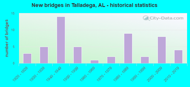
- New bridges - historical statistics
- 31920-1929
- 51930-1939
- 141940-1949
- 51950-1959
- 11960-1969
- 21970-1979
- 91980-1989
- 21990-1999
- 82000-2009
- 42010-2019

- Reconstructed bridges - Historical Statistics
- 11930-1939
- 11940-1949
- 01950-1959
- 01960-1969
- 01970-1979
- 11980-1989
- 31990-1999
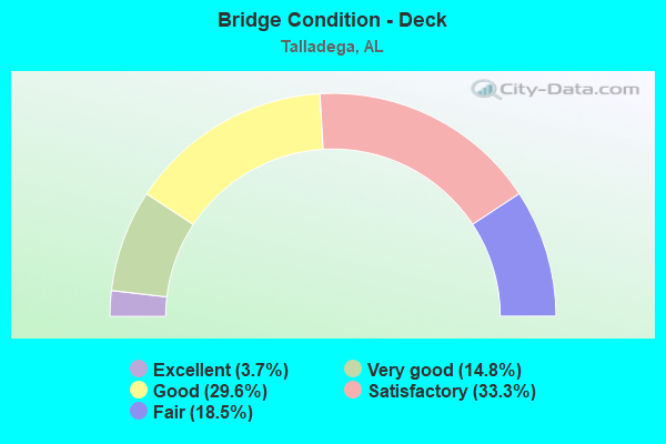
- Bridge Condition - Deck
- 3.7%Excellent
- 14.8%Very good
- 29.6%Good
- 33.3%Satisfactory
- 18.5%Fair
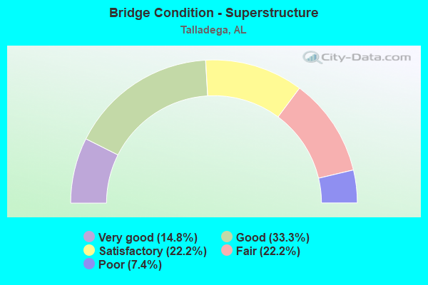
- Bridge Condition - Superstructure
- 14.8%Very good
- 33.3%Good
- 22.2%Satisfactory
- 22.2%Fair
- 7.4%Poor
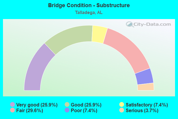
- Bridge Condition - Substructure
- 25.9%Very good
- 25.9%Good
- 7.4%Satisfactory
- 29.6%Fair
- 7.4%Poor
- 3.7%Serious
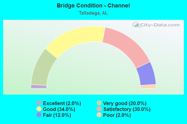
- Bridge Condition - Channel
- 2.0%Excellent
- 20.0%Very good
- 34.0%Good
- 30.0%Satisfactory
- 12.0%Fair
- 2.0%Poor
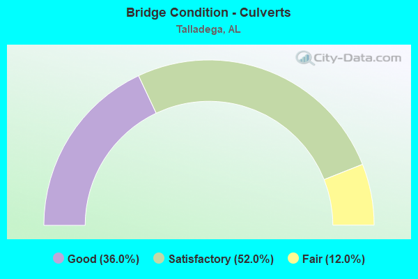
- Bridge Condition - Culverts
- 36.0%Good
- 52.0%Satisfactory
- 12.0%Fair
Find on map >> Show street view
Structure Number: 19398, Location: AT JCT. JACKSON TRACE (Lat: 33.510278, Lng: -86.106000), Route carried "on" structure: County highway 803, Year Built: 1980, Year Reconstructed: 2004, Status: Open, Structure Length: 0.63m (2.07ft), Average Daily Traffic: 125 (year 2018), Average Future Daily Traffic: 135 (year 2038), Design Load: HS 20, Features Intersected: SMALL PERIODIC STREAM, Facility Carried by Structure: PINE HILL ROAD
Minimum Vertical Clearance: 30+ m (98+ ft), Kilometerpoint: 0.000, Lanes on structure: 2, Owner: County Highway Agency, Approaching Roadway Width: 6.1m (20.0ft), Material/Design: Aluminum, Iron, Design/Construction: Culvert, Number Of Spans In Main Unit: 1, Length of Maximum Span: 6.3m (20.7ft)
Condition: Channel: Good, Culverts: Good, Operating Rating: 59.9 metric tons, Method Used To Determine Operating Rating: Load Factor (LF), Inventory Rating: 35.9 metric tons, Method Used To Determine Inventory Rating: Load Factor (LF), Structural Evaluation: Better than present minimum criteria, Waterway Adequacy: Better than present minimum criteria, Approach Roadway Alignment: Better than present minimum criteria, Length Of Structure Improvement: 1.24m (4.07ft), Designated Inspection Frequency: Every 24 months, Inspection Date: April 2020, Bridge Improvement Cost: $144,000, Roadway Improvement Cost: $14,000, Total Project Cost: $158,000 ( Estimate for 2022), Deck Structure Type: Aluminum
Find on map >> Show street view
Structure Number: 1951, Location: .25 (Lat: 33.356667, Lng: -86.215000), Route carried "on" structure: County highway 243, Year Built: 2007, Status: Open, Structure Length: 6.10m (20.01ft), Average Daily Traffic: 705 (year 2018), Truck Traffic: 10%, Average Future Daily Traffic: 970 (year 2038), Design Load: HS 20, Features Intersected: TALLADEGA CREEK
Minimum Vertical Clearance: 30+ m (98+ ft), Kilometerpoint: 0.000, Lanes on structure: 2, Owner: County Highway Agency, Approaching Roadway Width: 7.3m (24.0ft), Material/Design: Prestressed concrete, Design/Construction: Stringer/Multi-beam, Number Of Spans In Main Unit: 5, Length of Maximum Span: 12.2m (40.0ft), Curb-To-Curb Width: 8.5m (27.9ft), Out-to-Out Width: 9.4m (30.8ft)
Condition: Deck: Very good, Superstructure: Very good, Substructure: Very good, Channel: Very good, Operating Rating: 58.7 metric tons, Method Used To Determine Operating Rating: Load Factor (LF), Inventory Rating: 35.2 metric tons, Method Used To Determine Inventory Rating: Load Factor (LF), Structural Evaluation: Equal to present desirable criteria, Deck Geometry: Somewhat better than minimum adequacy, Waterway Adequacy: Equal to present desirable criteria, Approach Roadway Alignment: Equal to present desirable criteria, Length Of Structure Improvement: 7.14m (23.43ft), Designated Inspection Frequency: Every 24 months, Inspection Date: October 2021, Bridge Improvement Cost: $1,468,000, Roadway Improvement Cost: $147,000, Total Project Cost: $1,615,000 ( Estimate for 2019), Deck Structure Type: Concrete Cast-file-Place
Find on map >> Show street view
Structure Number: 20047, Location: 500 FT W OF ALLEN ST (Lat: 33.466683, Lng: -86.061750), Route carried "on" structure: City street , Year Built: 1940, Status: Open, Structure Length: 1.86m (6.10ft), Average Daily Traffic: 50 (year 2012), Average Future Daily Traffic: 55 (year 2042), Design Load: H 15, Features Intersected: BRANCH, Facility Carried by Structure: NAFF AVENUE
Minimum Vertical Clearance: 30+ m (98+ ft), Kilometerpoint: 5.955, Lanes on structure: 2, Owner: City or Municipal Highway Agency, Approaching Roadway Width: 6.1m (20.0ft), Material/Design: Steel, Design/Construction: Culvert, Number Of Spans In Main Unit: 4, Length of Maximum Span: 4.3m (14.1ft), Curb-To-Curb Width: 15.6m (51.2ft), Out-to-Out Width: 16.2m (53.1ft)
Condition: Channel: Satisfactory, Culverts: Satisfactory, Operating Rating: 34.2 metric tons, Method Used To Determine Operating Rating: Load Factor (LF), Inventory Rating: 27.3 metric tons, Method Used To Determine Inventory Rating: Load Factor (LF), Structural Evaluation: Equal to present minimum criteria, Deck Geometry: Superior to present desirable criteria, Waterway Adequacy: Equal to present minimum criteria, Approach Roadway Alignment: Better than present minimum criteria, Length Of Structure Improvement: 2.58m (8.46ft), Designated Inspection Frequency: Every 24 months, Inspection Date: January 2022, Bridge Improvement Cost: $790,000, Roadway Improvement Cost: $79,000, Total Project Cost: $869,000 ( Estimate for 2022)
Find on map >> Show street view
Structure Number: 20048, Location: 300 FT N OF NIMITZ AVE (Lat: 33.459639, Lng: -86.078861), Route carried "on" structure: City street , Year Built: 1940, Status: Open, Structure Length: 1.01m (3.31ft), Average Daily Traffic: 50 (year 2012), Average Future Daily Traffic: 55 (year 2042), Design Load: H 15, Features Intersected: BRANCH, Facility Carried by Structure: FRANKLIN DRIVE N.
Minimum Vertical Clearance: 30+ m (98+ ft), Kilometerpoint: 2.816, Lanes on structure: 2, Owner: City or Municipal Highway Agency, Approaching Roadway Width: 6.4m (21.0ft), Skew: 1 degrees, Material/Design: Steel, Design/Construction: Culvert, Number Of Spans In Main Unit: 2, Length of Maximum Span: 4.3m (14.1ft), Curb-To-Curb Width: 16.2m (53.1ft), Out-to-Out Width: 16.8m (55.1ft)
Condition: Channel: Satisfactory, Culverts: Satisfactory, Operating Rating: 34.2 metric tons, Method Used To Determine Operating Rating: Load Factor (LF), Inventory Rating: 27.3 metric tons, Method Used To Determine Inventory Rating: Load Factor (LF), Structural Evaluation: Equal to present minimum criteria, Deck Geometry: Superior to present desirable criteria, Waterway Adequacy: Better than present minimum criteria, Approach Roadway Alignment: Equal to present desirable criteria, Length Of Structure Improvement: 1.69m (5.54ft), Designated Inspection Frequency: Every 24 months, Inspection Date: January 2022, Bridge Improvement Cost: $615,000, Roadway Improvement Cost: $62,000, Total Project Cost: $677,000 ( Estimate for 2022)
Find on map >> Show street view
Structure Number: 20049, Location: 700 FT N OF ALLEN ST (Lat: 33.462139, Lng: -86.073306), Route carried "on" structure: City street , Year Built: 1940, Status: Open, Structure Length: 1.25m (4.10ft), Average Daily Traffic: 1,000 (year 2012), Truck Traffic: 3%, Average Future Daily Traffic: 1,100 (year 2042), Design Load: H 15, Features Intersected: BRANCH, Facility Carried by Structure: NIMITZ AVENUE
Minimum Vertical Clearance: 30+ m (98+ ft), Kilometerpoint: 3.943, Lanes on structure: 2, Owner: City or Municipal Highway Agency, Approaching Roadway Width: 6.2m (20.3ft), Skew: 4 degrees, Material/Design: Steel, Design/Construction: Culvert, Number Of Spans In Main Unit: 2, Length of Maximum Span: 4.3m (14.1ft), Curb-To-Curb Width: 13.1m (43.0ft), Out-to-Out Width: 13.7m (44.9ft)
Condition: Channel: Satisfactory, Culverts: Satisfactory, Operating Rating: 36.7 metric tons, Method Used To Determine Operating Rating: Load Factor (LF), Inventory Rating: 29.8 metric tons, Method Used To Determine Inventory Rating: Load Factor (LF), Structural Evaluation: Equal to present minimum criteria, Deck Geometry: Superior to present desirable criteria, Waterway Adequacy: Equal to present minimum criteria, Approach Roadway Alignment: Better than present minimum criteria, Length Of Structure Improvement: 1.92m (6.30ft), Designated Inspection Frequency: Every 24 months, Inspection Date: January 2022, Bridge Improvement Cost: $700,000, Roadway Improvement Cost: $70,000, Total Project Cost: $770,000 ( Estimate for 2022)
Find on map >> Show street view
Structure Number: 2005, Location: INT. OF ALLEN STREET (Lat: 33.461889, Lng: -86.069639), Route carried "on" structure: City street , Year Built: 1940, Status: Open, Structure Length: 1.37m (4.49ft), Average Daily Traffic: 400 (year 2012), Truck Traffic: 5%, Average Future Daily Traffic: 440 (year 2042), Design Load: H 15, Features Intersected: BRANCH, Facility Carried by Structure: HORNE STREET
Minimum Vertical Clearance: 30+ m (98+ ft), Kilometerpoint: 4.345, Lanes on structure: 2, Owner: City or Municipal Highway Agency, Approaching Roadway Width: 6.1m (20.0ft), Material/Design: Steel, Design/Construction: Culvert, Number Of Spans In Main Unit: 3, Length of Maximum Span: 4.3m (14.1ft), Curb-To-Curb Width: 34.6m (113.5ft), Out-to-Out Width: 35.2m (115.5ft)
Condition: Channel: Satisfactory, Culverts: Satisfactory, Operating Rating: 41.5 metric tons, Method Used To Determine Operating Rating: Load Factor (LF), Inventory Rating: 34.6 metric tons, Method Used To Determine Inventory Rating: Load Factor (LF), Structural Evaluation: Equal to present minimum criteria, Deck Geometry: Superior to present desirable criteria, Waterway Adequacy: Better than present minimum criteria, Approach Roadway Alignment: Better than present minimum criteria, Length Of Structure Improvement: 2.05m (6.73ft), Designated Inspection Frequency: Every 24 months, Inspection Date: January 2022, Bridge Improvement Cost: $1,359,000, Roadway Improvement Cost: $136,000, Total Project Cost: $1,495,000 ( Estimate for 2022)
Find on map >> Show street view
Structure Number: 20051, Location: 100 FT W OF JUDY CIR (Lat: 33.461083, Lng: -86.075722), Route carried "on" structure: City street , Year Built: 1940, Status: Open, Structure Length: 0.75m (2.46ft), Average Daily Traffic: 400 (year 2012), Truck Traffic: 5%, Average Future Daily Traffic: 440 (year 2042), Design Load: H 15, Features Intersected: BRANCH, Facility Carried by Structure: ALLEN STREET
Minimum Vertical Clearance: 30+ m (98+ ft), Kilometerpoint: 3.701, Lanes on structure: 2, Owner: City or Municipal Highway Agency, Approaching Roadway Width: 6.1m (20.0ft), Material/Design: Steel, Design/Construction: Culvert, Number Of Spans In Main Unit: 2, Length of Maximum Span: 3.7m (12.1ft), Curb-To-Curb Width: 12.5m (41.0ft), Out-to-Out Width: 13.1m (43.0ft)
Condition: Channel: Satisfactory, Culverts: Satisfactory, Operating Rating: 63.0 metric tons, Method Used To Determine Operating Rating: Load Factor (LF), Inventory Rating: 58.1 metric tons, Method Used To Determine Inventory Rating: Load Factor (LF), Structural Evaluation: Equal to present minimum criteria, Deck Geometry: Superior to present desirable criteria, Waterway Adequacy: Better than present minimum criteria, Approach Roadway Alignment: Better than present minimum criteria, Length Of Structure Improvement: 1.39m (4.56ft), Designated Inspection Frequency: Every 24 months, Inspection Date: January 2022, Bridge Improvement Cost: $346,000, Roadway Improvement Cost: $35,000, Total Project Cost: $381,000 ( Estimate for 2022)
Find on map >> Show street view
Structure Number: 20052, Location: 400 FT E OF GREEN ACRES (Lat: 33.458639, Lng: -86.080083), Route carried "on" structure: City street , Year Built: 1940, Status: Open, Structure Length: 1.25m (4.10ft), Average Daily Traffic: 1,000 (year 2012), Truck Traffic: 5%, Average Future Daily Traffic: 1,100 (year 2042), Design Load: H 15, Features Intersected: BRANCH, Facility Carried by Structure: NIMITZ AVENUE
Minimum Vertical Clearance: 30+ m (98+ ft), Kilometerpoint: 2.897, Lanes on structure: 2, Owner: City or Municipal Highway Agency, Approaching Roadway Width: 6.3m (20.7ft), Skew: 4 degrees, Material/Design: Steel, Design/Construction: Culvert, Number Of Spans In Main Unit: 2, Length of Maximum Span: 4.3m (14.1ft), Curb or Sidewalk Widths: Left: 0.0m, Right: 1.2m (3.9ft), Curb-To-Curb Width: 13.1m (43.0ft), Out-to-Out Width: 13.7m (44.9ft)
Condition: Channel: Satisfactory, Culverts: Satisfactory, Operating Rating: 34.2 metric tons, Method Used To Determine Operating Rating: Load Factor (LF), Inventory Rating: 27.3 metric tons, Method Used To Determine Inventory Rating: Load Factor (LF), Structural Evaluation: Equal to present minimum criteria, Deck Geometry: Superior to present desirable criteria, Waterway Adequacy: Better than present minimum criteria, Approach Roadway Alignment: Equal to present desirable criteria, Length Of Structure Improvement: 1.92m (6.30ft), Designated Inspection Frequency: Every 24 months, Inspection Date: January 2022, Bridge Improvement Cost: $700,000, Roadway Improvement Cost: $70,000, Total Project Cost: $770,000 ( Estimate for 2022)
Find on map >> Show street view
Structure Number: 20593, Location: TALLADEGA (Lat: 33.440506, Lng: -86.096744), Route carried "on" structure: City street , Year Built: 2012, Status: Open, Structure Length: 0.98m (3.22ft), Average Daily Traffic: 3,000 (year 2012), Truck Traffic: 5%, Average Future Daily Traffic: 3,200 (year 2041), Design Load: HS 20, Features Intersected: ISBELL BRANCH, Facility Carried by Structure: 17TH ST
Minimum Vertical Clearance: 30+ m (98+ ft), Kilometerpoint: 0.200, Lanes on structure: 2, Owner: City or Municipal Highway Agency, Approaching Roadway Width: 7.9m (25.9ft), Skew: 3 degrees, Material/Design: Concrete, Design/Construction: Channel Beam, Number Of Spans In Main Unit: 1, Length of Maximum Span: 9.8m (32.2ft), Curb-To-Curb Width: 7.9m (25.9ft), Out-to-Out Width: 9.1m (29.9ft)
Condition: Deck: Good, Superstructure: Good, Substructure: Good, Channel: Satisfactory, Operating Rating: 69.9 metric tons, Method Used To Determine Operating Rating: Load Factor (LF), Inventory Rating: 42.0 metric tons, Method Used To Determine Inventory Rating: Load Factor (LF), Structural Evaluation: Better than present minimum criteria, Deck Geometry: High priority of corrective action, Waterway Adequacy: Equal to present desirable criteria, Approach Roadway Alignment: Equal to present desirable criteria, Length Of Structure Improvement: 1.64m (5.38ft), Designated Inspection Frequency: Every 24 months, Inspection Date: November 2021, Bridge Improvement Cost: $338,000, Roadway Improvement Cost: $34,000, Total Project Cost: $372,000 ( Estimate for 2022), Deck Structure Type: Concrete Precast Panels
Find on map >> Show street view
Structure Number: 21268, Location: .06Mi W of Jackson St (Lat: 33.439389, Lng: -86.110861), Route carried "on" structure: City street , Year Built: 2019, Status: Open, Structure Length: 1.34m (4.40ft), Average Daily Traffic: 106 (year 2016), Average Future Daily Traffic: 159 (year 2041), Design Load: HS 20, Features Intersected: Town Creek, Facility Carried by Structure: Isbell Circle
Minimum Vertical Clearance: 30+ m (98+ ft), Kilometerpoint: 0.449, Lanes on structure: 2, Owner: City or Municipal Highway Agency, Approaching Roadway Width: 5.5m (18.0ft), Skew: 4 degrees, Material/Design: Concrete, Design/Construction: Culvert, Number Of Spans In Main Unit: 3, Length of Maximum Span: 4.5m (14.8ft)
Condition: Channel: Good, Culverts: Good, Operating Rating: 53.2 metric tons, Method Used To Determine Operating Rating: Load Factor (LF), Inventory Rating: 31.8 metric tons, Method Used To Determine Inventory Rating: Load Factor (LF), Structural Evaluation: Better than present minimum criteria, Waterway Adequacy: Better than present minimum criteria, Approach Roadway Alignment: Better than present minimum criteria, Length Of Structure Improvement: 2.02m (6.63ft), Designated Inspection Frequency: Every 24 months, Inspection Date: March 2021, Bridge Improvement Cost: $455,000, Roadway Improvement Cost: $46,000, Total Project Cost: $501,000 ( Estimate for 2022)
Find on map >> Show street view
Structure Number: 21269, Location: 200' East of West St (Lat: 33.437189, Lng: -86.105850), Route carried "on" structure: City street , Year Built: 2019, Status: Open, Structure Length: 0.91m (2.99ft), Average Daily Traffic: 1,730 (year 2016), Truck Traffic: 2%, Average Future Daily Traffic: 2,121 (year 2041), Design Load: HS 20, Features Intersected: Isbell Branch, Facility Carried by Structure: Coosa St West
Minimum Vertical Clearance: 30+ m (98+ ft), Kilometerpoint: 0.499, Lanes on structure: 2, Owner: City or Municipal Highway Agency, Approaching Roadway Width: 6.7m (22.0ft), Skew: 3 degrees, Material/Design: Concrete, Design/Construction: Culvert, Number Of Spans In Main Unit: 2, Length of Maximum Span: 4.6m (15.1ft)
Condition: Channel: Very good, Culverts: Good, Operating Rating: 88.9 metric tons, Method Used To Determine Operating Rating: Load Factor (LF), Inventory Rating: 64.5 metric tons, Method Used To Determine Inventory Rating: Load Factor (LF), Structural Evaluation: Better than present minimum criteria, Waterway Adequacy: Better than present minimum criteria, Approach Roadway Alignment: Better than present minimum criteria, Length Of Structure Improvement: 1.58m (5.18ft), Designated Inspection Frequency: Every 24 months, Inspection Date: March 2021, Bridge Improvement Cost: $328,000, Roadway Improvement Cost: $33,000, Total Project Cost: $361,000 ( Estimate for 2022)
Find on map >> Show street view
Structure Number: 2127, Location: 0.1 MI N of North St. W (Lat: 33.436486, Lng: -86.106578), Route carried "on" structure: City street , Year Built: 2019, Status: Open, Structure Length: 0.86m (2.82ft), Average Daily Traffic: 1,050 (year 2012), Truck Traffic: 3%, Average Future Daily Traffic: 1,560 (year 2041), Design Load: HS 20, Features Intersected: Isbell Branch, Facility Carried by Structure: West St N
Minimum Vertical Clearance: 30+ m (98+ ft), Kilometerpoint: 0.200, Lanes on structure: 2, Owner: City or Municipal Highway Agency, Approaching Roadway Width: 6.7m (22.0ft), Skew: 3 degrees, Material/Design: Concrete, Design/Construction: Culvert, Number Of Spans In Main Unit: 2, Length of Maximum Span: 4.3m (14.1ft), Curb or Sidewalk Widths: Left: 1.5m (4.9ft), Right: 0.0m
Condition: Channel: Very good, Culverts: Good, Operating Rating: 69.9 metric tons, Method Used To Determine Operating Rating: Load Factor (LF), Inventory Rating: 41.9 metric tons, Method Used To Determine Inventory Rating: Load Factor (LF), Structural Evaluation: Better than present minimum criteria, Waterway Adequacy: Equal to present desirable criteria, Approach Roadway Alignment: Equal to present desirable criteria, Length Of Structure Improvement: 1.53m (5.02ft), Designated Inspection Frequency: Every 24 months, Inspection Date: March 2021, Bridge Improvement Cost: $432,000, Roadway Improvement Cost: $43,000, Total Project Cost: $475,000 ( Estimate for 2022)
Find on map >> Show street view
Structure Number: 12002, Location: CITY OF TALLADEGA (Lat: 33.425825, Lng: -86.116014), Route carried "under" structure: State highway 21, Year Built: 1978, Structure Length: 0. m, Average Daily Traffic: 5,359 (year 2018), Truck Traffic: 9%, Features Intersected: AL 21, Facility Carried by Structure: PEDESTRIAN OVERPAS
Minimum Vertical Clearance: 5.66m (18.57ft), Kilometerpoint: 369.338, Lanes under structure: 2, Material/Design: Prestressed concrete, Design/Construction: Stringer/Multi-beam, Length of Maximum Span: 30.5m (100.1ft)