Bridge Statistics for Thomasville, North Carolina (NC)
Condition, Traffic, Stress, Structural Evaluation, Project Costs
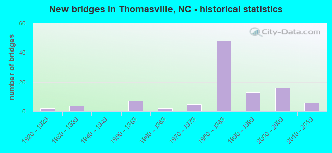
- New bridges - historical statistics
- 21920-1929
- 41930-1939
- 71950-1959
- 21960-1969
- 51970-1979
- 481980-1989
- 131990-1999
- 162000-2009
- 62010-2019
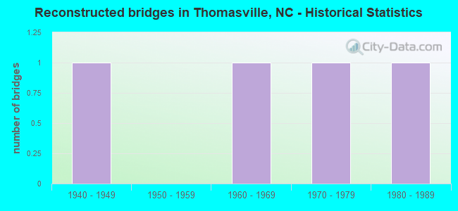
- Reconstructed bridges - Historical Statistics
- 11940-1949
- 01950-1959
- 11960-1969
- 11970-1979
- 11980-1989
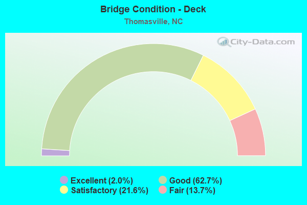
- Bridge Condition - Deck
- 2.0%Excellent
- 62.7%Good
- 21.6%Satisfactory
- 13.7%Fair
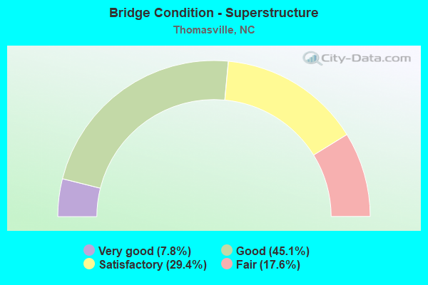
- Bridge Condition - Superstructure
- 7.8%Very good
- 45.1%Good
- 29.4%Satisfactory
- 17.6%Fair

- Bridge Condition - Substructure
- 2.0%Excellent
- 5.9%Very good
- 52.9%Good
- 25.5%Satisfactory
- 9.8%Fair
- 3.9%Poor
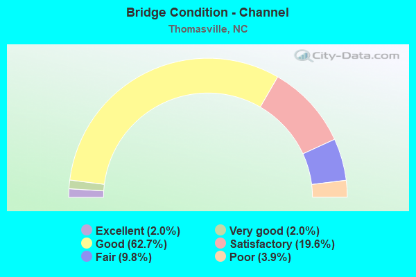
- Bridge Condition - Channel
- 2.0%Excellent
- 2.0%Very good
- 62.7%Good
- 19.6%Satisfactory
- 9.8%Fair
- 3.9%Poor
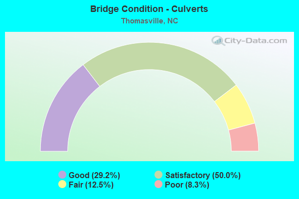
- Bridge Condition - Culverts
- 29.2%Good
- 50.0%Satisfactory
- 12.5%Fair
- 8.3%Poor
Find on map >> Show street view
Structure Number: 570469, Location: 0.3 MI. S. JCT. SR2032 (Lat: 35.876925, Lng: -80.083614), Route carried "on" structure: State highway 2183, Year Built: 1938, Status: Open, Structure Length: 0.97m (3.18ft), Average Daily Traffic: 4,100 (year 2019), Truck Traffic: 6%, Average Future Daily Traffic: 8,200 (year 2040), Design Load: HS 15, Features Intersected: NORTH HAMBY'S CREEK
Minimum Vertical Clearance: 30+ m (98+ ft), Kilometerpoint: 0.000, Lanes on structure: 2, Owner: State Highway Agency, Approaching Roadway Width: 8.8m (28.9ft), Material/Design: Concrete, Design/Construction: Slab, Number Of Spans In Main Unit: 2, Length of Maximum Span: 4.8m (15.7ft), Curb or Sidewalk Widths: Left: 1.2m (3.9ft), Right: 1.2m (3.9ft), Curb-To-Curb Width: 7.6m (24.9ft), Out-to-Out Width: 10.3m (33.8ft)
Condition: Deck: Fair, Superstructure: Fair, Substructure: Fair, Channel: Fair, Operating Rating: 31.7 metric tons, Method Used To Determine Operating Rating: Field evaluation and documented engineering judgment, Inventory Rating: 24.4 metric tons, Method Used To Determine Inventory Rating: Field evaluation and documented engineering judgment, Structural Evaluation: Somewhat better than minimum adequacy, Deck Geometry: High priority of replacement, Waterway Adequacy: Better than present minimum criteria, Approach Roadway Alignment: Equal to present desirable criteria, Designated Inspection Frequency: Every 24 months, Inspection Date: June 2021, Deck Structure Type: Concrete Cast-file-Place, Wearing Surface/Protective System: Wearing Surface: Bituminous
Find on map >> Show street view
Structure Number: 570474, Location: 1.0 MI. N. JCT. SR2010 (Lat: 35.827831, Lng: -80.161206), Route carried "on" structure: Interstate 85, Year Built: 1981, Status: Open, Structure Length: 9.72m (31.89ft), Average Daily Traffic: 260,000 (year 2015), Truck Traffic: 23%, Average Future Daily Traffic: 520,000 (year 2040), Design Load: HS 20+Mod, Features Intersected: I85N
Minimum Vertical Clearance: 30+ m (98+ ft), Kilometerpoint: 29.809, Lanes on structure: 3, Lanes under structure: 3, Base Highway Network: Yes (Inventory Route: 1, Subroute: 85), Owner: State Highway Agency, Approaching Roadway Width: 17.0m (55.8ft), Skew: 5 degrees, Material/Design: Steel, Design/Construction: Stringer/Multi-beam, Number Of Spans In Main Unit: 3, Length of Maximum Span: 53.3m (174.9ft), Curb-To-Curb Width: 17.0m (55.8ft), Out-to-Out Width: 17.9m (58.7ft)
Condition: Deck: Good, Superstructure: Good, Substructure: Satisfactory, Operating Rating: 79.8 metric tons, Method Used To Determine Operating Rating: Load Factor (LF), Inventory Rating: 48.0 metric tons, Method Used To Determine Inventory Rating: Load Factor (LF), Structural Evaluation: Equal to present minimum criteria, Deck Geometry: Equal to present minimum criteria, Underclear: Equal to present minimum criteria, Approach Roadway Alignment: Equal to present desirable criteria, Designated Inspection Frequency: Every 24 months, Inspection Date: April 2020, Deck Structure Type: Concrete Cast-file-Place, Wearing Surface/Protective System: Wearing Surface: Monolithic Concrete
Find on map >> Show street view
Structure Number: 570475, Location: 1.3 MI. S. JCT. SR2025 (Lat: 35.829986, Lng: -80.157244), Route carried "on" structure: Interstate 85, Year Built: 1981, Status: Open, Structure Length: 4.14m (13.58ft), Average Daily Traffic: 27,750 (year 2018), Truck Traffic: 23%, Average Future Daily Traffic: 55,500 (year 2040), Design Load: HS 20+Mod, Features Intersected: HAMBY'S CREEK
Minimum Vertical Clearance: 30+ m (98+ ft), Kilometerpoint: 29.870, Lanes on structure: 3, Base Highway Network: Yes (Inventory Route: 1, Subroute: 85), Owner: State Highway Agency, Approaching Roadway Width: 17.0m (55.8ft), Material/Design: Prestressed concrete, Design/Construction: Stringer/Multi-beam, Number Of Spans In Main Unit: 3, Length of Maximum Span: 13.4m (44.0ft), Curb-To-Curb Width: 17.0m (55.8ft), Out-to-Out Width: 17.9m (58.7ft)
Condition: Deck: Good, Superstructure: Good, Substructure: Good, Channel: Good, Operating Rating: 89.8 metric tons, Method Used To Determine Operating Rating: Load Factor (LF), Inventory Rating: 47.1 metric tons, Method Used To Determine Inventory Rating: Load Factor (LF), Structural Evaluation: Better than present minimum criteria, Deck Geometry: Equal to present minimum criteria, Waterway Adequacy: Better than present minimum criteria, Approach Roadway Alignment: Equal to present desirable criteria, Designated Inspection Frequency: Every 24 months, Inspection Date: April 2020, Deck Structure Type: Concrete Cast-file-Place, Wearing Surface/Protective System: Wearing Surface: Monolithic Concrete
Find on map >> Show street view
Structure Number: 570477, Location: 0.5 MI. W. JCT. SR2010 (Lat: 35.835611, Lng: -80.135856), Route carried "on" structure: State highway 2025, Year Built: 1981, Status: Open, Structure Length: 4.99m (16.37ft), Average Daily Traffic: 340 (year 2017), Truck Traffic: 7%, Average Future Daily Traffic: 680 (year 2040), Design Load: HS 15, Features Intersected: I85 SBL
Minimum Vertical Clearance: 30+ m (98+ ft), Kilometerpoint: 30.480, Lanes on structure: 2, Lanes under structure: 3, Owner: State Highway Agency, Approaching Roadway Width: 6.0m (19.7ft), Skew: 1 degrees, Material/Design: Steel, Design/Construction: Stringer/Multi-beam, Number Of Spans In Main Unit: 3, Length of Maximum Span: 30.7m (100.7ft), Curb-To-Curb Width: 8.9m (29.2ft), Out-to-Out Width: 9.7m (31.8ft)
Condition: Deck: Good, Superstructure: Satisfactory, Substructure: Satisfactory, Operating Rating: 49.8 metric tons, Method Used To Determine Operating Rating: Load Factor (LF), Inventory Rating: 29.9 metric tons, Method Used To Determine Inventory Rating: Load Factor (LF), Structural Evaluation: Equal to present minimum criteria, Deck Geometry: Equal to present minimum criteria, Underclear: Equal to present minimum criteria, Approach Roadway Alignment: Equal to present desirable criteria, Designated Inspection Frequency: Every 24 months, Inspection Date: April 2020, Deck Structure Type: Concrete Cast-file-Place, Wearing Surface/Protective System: Wearing Surface: Monolithic Concrete
Find on map >> Show street view
Structure Number: 570478, Location: 1.1 MI. S. JCT. SR2031 (Lat: 35.839289, Lng: -80.137517), Route carried "on" structure: Interstate 85, Year Built: 1981, Status: Open, Structure Length: 3.93m (12.89ft), Average Daily Traffic: 52,000 (year 2015), Truck Traffic: 16%, Average Future Daily Traffic: 104,000 (year 2040), Design Load: HS 20+Mod, Features Intersected: SR2025
Minimum Vertical Clearance: 30+ m (98+ ft), Kilometerpoint: 30.297, Lanes on structure: 3, Lanes under structure: 2, Base Highway Network: Yes (Inventory Route: 1, Subroute: 85), Owner: State Highway Agency, Approaching Roadway Width: 17.0m (55.8ft), Skew: 2 degrees, Material/Design: Steel, Design/Construction: Stringer/Multi-beam, Number Of Spans In Main Unit: 3, Length of Maximum Span: 15.2m (49.9ft), Curb-To-Curb Width: 17.0m (55.8ft), Out-to-Out Width: 17.9m (58.7ft)
Condition: Deck: Good, Superstructure: Good, Substructure: Good, Operating Rating: 60.7 metric tons, Method Used To Determine Operating Rating: Load Factor (LF), Inventory Rating: 36.2 metric tons, Method Used To Determine Inventory Rating: Load Factor (LF), Structural Evaluation: Better than present minimum criteria, Deck Geometry: Equal to present minimum criteria, Underclear: Meets minimum limits, Approach Roadway Alignment: Equal to present desirable criteria, Designated Inspection Frequency: Every 24 months, Inspection Date: April 2020, Deck Structure Type: Concrete Cast-file-Place, Wearing Surface/Protective System: Wearing Surface: Monolithic Concrete
Find on map >> Show street view
Structure Number: 570479, Location: 0.3 MI. S. JCT. SR2055 (Lat: 35.860117, Lng: -80.072564), Route carried "on" structure: Interstate 85, Year Built: 1981, Status: Open, Structure Length: 5.15m (16.90ft), Average Daily Traffic: 32,000 (year 2018), Truck Traffic: 16%, Average Future Daily Traffic: 64,000 (year 2040), Design Load: HS 20+Mod, Features Intersected: NC109
Minimum Vertical Clearance: 30+ m (98+ ft), Kilometerpoint: 31.516, Lanes on structure: 3, Lanes under structure: 5, Base Highway Network: Yes (Inventory Route: 1, Subroute: 85), Owner: State Highway Agency, Approaching Roadway Width: 17.0m (55.8ft), Skew: 10 degrees, Material/Design: Steel, Design/Construction: Stringer/Multi-beam, Number Of Spans In Main Unit: 3, Length of Maximum Span: 28.9m (94.8ft), Curb-To-Curb Width: 17.0m (55.8ft), Out-to-Out Width: 17.9m (58.7ft)
Condition: Deck: Good, Superstructure: Satisfactory, Substructure: Satisfactory, Operating Rating: 89.8 metric tons, Method Used To Determine Operating Rating: Load Factor (LF), Inventory Rating: 63.5 metric tons, Method Used To Determine Inventory Rating: Load Factor (LF), Structural Evaluation: Equal to present minimum criteria, Deck Geometry: Equal to present minimum criteria, Underclear: Meets minimum limits, Approach Roadway Alignment: Equal to present desirable criteria, Designated Inspection Frequency: Every 24 months, Inspection Date: March 2020, Deck Structure Type: Concrete Cast-file-Place, Wearing Surface/Protective System: Wearing Surface: Monolithic Concrete
Find on map >> Show street view
Structure Number: 57048, Location: 0.3 MI. S. JCT. SR2055 (Lat: 35.860400, Lng: -80.072536), Route carried "on" structure: Interstate 85, Year Built: 1981, Status: Open, Structure Length: 5.09m (16.70ft), Average Daily Traffic: 30,000 (year 2018), Truck Traffic: 16%, Average Future Daily Traffic: 60,000 (year 2040), Design Load: HS 20+Mod, Features Intersected: NC109
Minimum Vertical Clearance: 30+ m (98+ ft), Kilometerpoint: 31.516, Lanes on structure: 3, Lanes under structure: 5, Base Highway Network: Yes (Inventory Route: 1, Subroute: 85), Owner: State Highway Agency, Approaching Roadway Width: 16.4m (53.8ft), Skew: 10 degrees, Material/Design: Steel, Design/Construction: Stringer/Multi-beam, Number Of Spans In Main Unit: 3, Length of Maximum Span: 28.9m (94.8ft), Curb-To-Curb Width: 16.8m (55.1ft), Out-to-Out Width: 17.9m (58.7ft)
Condition: Deck: Good, Superstructure: Satisfactory, Substructure: Fair, Operating Rating: 89.8 metric tons, Method Used To Determine Operating Rating: Load Factor (LF), Inventory Rating: 63.5 metric tons, Method Used To Determine Inventory Rating: Load Factor (LF), Structural Evaluation: Somewhat better than minimum adequacy, Deck Geometry: Equal to present minimum criteria, Underclear: Meets minimum limits, Approach Roadway Alignment: Equal to present desirable criteria, Designated Inspection Frequency: Every 24 months, Inspection Date: March 2020, Deck Structure Type: Concrete Cast-file-Place, Wearing Surface/Protective System: Wearing Surface: Monolithic Concrete, Membrane: Built-up, Deck Protection: Epoxy Coated Reinforcing
Find on map >> Show street view
Structure Number: 570482, Location: 0.1 MI. E. JCT. SR2028 (Lat: 35.848986, Lng: -80.122467), Route carried "on" structure: State highway 2031, Year Built: 1981, Status: Open, Structure Length: 5.18m (16.99ft), Average Daily Traffic: 1,700 (year 2018), Truck Traffic: 6%, Average Future Daily Traffic: 3,400 (year 2040), Design Load: HS 15, Features Intersected: I85 N
Minimum Vertical Clearance: 30+ m (98+ ft), Kilometerpoint: 30.693, Lanes on structure: 2, Lanes under structure: 3, Owner: State Highway Agency, Approaching Roadway Width: 7.3m (24.0ft), Skew: 2 degrees, Material/Design: Steel, Design/Construction: Stringer/Multi-beam, Number Of Spans In Main Unit: 3, Length of Maximum Span: 32.6m (107.0ft), Curb-To-Curb Width: 12.1m (39.7ft), Out-to-Out Width: 13.0m (42.7ft)
Condition: Deck: Satisfactory, Superstructure: Fair, Substructure: Satisfactory, Operating Rating: 89.8 metric tons, Method Used To Determine Operating Rating: Load Factor (LF), Inventory Rating: 57.1 metric tons, Method Used To Determine Inventory Rating: Load Factor (LF), Structural Evaluation: Somewhat better than minimum adequacy, Deck Geometry: Equal to present minimum criteria, Underclear: Somewhat better than minimum adequacy, Approach Roadway Alignment: Equal to present desirable criteria, Designated Inspection Frequency: Every 24 months, Inspection Date: March 2020, Deck Structure Type: Concrete Cast-file-Place, Wearing Surface/Protective System: Wearing Surface: Monolithic Concrete
Find on map >> Show street view
Structure Number: 570483, Location: 0.3 MI. W. JCT. SR2030 (Lat: 35.846958, Lng: -80.122672), Route carried "on" structure: State highway 2031, Year Built: 1981, Status: Open, Structure Length: 5.94m (19.49ft), Average Daily Traffic: 13,000 (year 2018), Truck Traffic: 6%, Average Future Daily Traffic: 26,000 (year 2040), Design Load: HS 15, Features Intersected: I85S
Minimum Vertical Clearance: 30+ m (98+ ft), Kilometerpoint: 0.000, Lanes on structure: 2, Lanes under structure: 3, Owner: State Highway Agency, Approaching Roadway Width: 7.3m (24.0ft), Skew: 3 degrees, Material/Design: Steel, Design/Construction: Stringer/Multi-beam, Number Of Spans In Main Unit: 3, Length of Maximum Span: 36.5m (119.8ft), Curb-To-Curb Width: 12.1m (39.7ft), Out-to-Out Width: 13.0m (42.7ft)
Condition: Deck: Good, Superstructure: Good, Substructure: Good, Operating Rating: 70.7 metric tons, Method Used To Determine Operating Rating: Load Factor (LF), Inventory Rating: 41.7 metric tons, Method Used To Determine Inventory Rating: Load Factor (LF), Structural Evaluation: Better than present minimum criteria, Deck Geometry: Somewhat better than minimum adequacy, Underclear: Better than present minimum criteria, Approach Roadway Alignment: Equal to present desirable criteria, Designated Inspection Frequency: Every 24 months, Inspection Date: April 2020, Deck Structure Type: Concrete Cast-file-Place, Wearing Surface/Protective System: Wearing Surface: Monolithic Concrete
Find on map >> Show street view
Structure Number: 570484, Location: 1.2 MI. S. JCT. SR2085 (Lat: 35.847481, Lng: -80.121678), Route carried "on" structure: Interstate 85, Year Built: 1981, Status: Open, Structure Length: 1.40m (4.59ft), Average Daily Traffic: 29,000 (year 2019), Truck Traffic: 16%, Average Future Daily Traffic: 58,000 (year 2040), Design Load: HS 20+Mod, Features Intersected: HAMBY CREEK
Minimum Vertical Clearance: 30+ m (98+ ft), Kilometerpoint: 30.663, Lanes on structure: 3, Base Highway Network: Yes (Inventory Route: 1, Subroute: 85), Owner: State Highway Agency, Approaching Roadway Width: 15.2m (49.9ft), Material/Design: Concrete continuous, Design/Construction: Culvert, Number Of Spans In Main Unit: 3, Length of Maximum Span: 4.5m (14.8ft)
Condition: Channel: Good, Culverts: Satisfactory, Operating Rating: 64.4 metric tons, Method Used To Determine Operating Rating: Load and Resistance Factor (LRFR), Inventory Rating: 48.9 metric tons, Method Used To Determine Inventory Rating: Load and Resistance Factor (LRFR), Structural Evaluation: Equal to present minimum criteria, Waterway Adequacy: Better than present minimum criteria, Approach Roadway Alignment: Equal to present desirable criteria, Designated Inspection Frequency: Every 24 months, Inspection Date: June 2021
Find on map >> Show street view
Structure Number: 570485, Location: 1.0 MI. S. JCT. SR2085 (Lat: 35.849511, Lng: -80.118931), Route carried "on" structure: Interstate 85, Year Built: 1981, Status: Open, Structure Length: 8.68m (28.48ft), Average Daily Traffic: 31,000 (year 2018), Truck Traffic: 16%, Average Future Daily Traffic: 62,000 (year 2040), Design Load: HS 20+Mod, Features Intersected: I85 SBL
Minimum Vertical Clearance: 30+ m (98+ ft), Kilometerpoint: 30.663, Lanes on structure: 3, Lanes under structure: 3, Base Highway Network: Yes (Inventory Route: 1, Subroute: 85), Owner: State Highway Agency, Approaching Roadway Width: 15.2m (49.9ft), Skew: 5 degrees, Material/Design: Steel, Design/Construction: Stringer/Multi-beam, Number Of Spans In Main Unit: 3, Length of Maximum Span: 52.4m (171.9ft), Curb-To-Curb Width: 17.0m (55.8ft), Out-to-Out Width: 17.9m (58.7ft)
Condition: Deck: Good, Superstructure: Satisfactory, Substructure: Good, Operating Rating: 48.0 metric tons, Method Used To Determine Operating Rating: Load Factor (LF), Inventory Rating: 29.0 metric tons, Method Used To Determine Inventory Rating: Load Factor (LF), Structural Evaluation: Equal to present minimum criteria, Deck Geometry: Equal to present minimum criteria, Underclear: Equal to present minimum criteria, Approach Roadway Alignment: Equal to present desirable criteria, Designated Inspection Frequency: Every 24 months, Inspection Date: April 2020, Deck Structure Type: Concrete Cast-file-Place, Wearing Surface/Protective System: Wearing Surface: Epoxy Overlay
Find on map >> Show street view
Structure Number: 570486, Location: 0.6 MI. S. JCT. SR2085 (Lat: 35.850536, Lng: -80.113586), Route carried "on" structure: Interstate 85, Year Built: 1981, Status: Open, Structure Length: 1.31m (4.30ft), Average Daily Traffic: 27,750 (year 2018), Truck Traffic: 16%, Average Future Daily Traffic: 55,500 (year 2040), Design Load: HS 20+Mod, Features Intersected: HAMBY'S CREEK
Minimum Vertical Clearance: 30+ m (98+ ft), Kilometerpoint: 30.785, Lanes on structure: 3, Base Highway Network: Yes (Inventory Route: 1, Subroute: 85), Owner: State Highway Agency, Approaching Roadway Width: 18.2m (59.7ft), Skew: 13 degrees, Material/Design: Concrete continuous, Design/Construction: Culvert, Number Of Spans In Main Unit: 3, Length of Maximum Span: 3.6m (11.8ft)
Condition: Channel: Good, Culverts: Fair, Operating Rating: 89.8 metric tons, Method Used To Determine Operating Rating: Load and Resistance Factor (LRFR), Inventory Rating: 89.8 metric tons, Method Used To Determine Inventory Rating: Load and Resistance Factor (LRFR), Structural Evaluation: Somewhat better than minimum adequacy, Waterway Adequacy: Better than present minimum criteria, Approach Roadway Alignment: Equal to present desirable criteria, Designated Inspection Frequency: Every 24 months, Inspection Date: Febuary 2022
Find on map >> Show street view
Structure Number: 570487, Location: 0.6 MI. S. JCT. SR2085 (Lat: 35.852081, Lng: -80.113436), Route carried "on" structure: Interstate 85, Year Built: 1981, Status: Open, Structure Length: 1.31m (4.30ft), Average Daily Traffic: 31,000 (year 2018), Truck Traffic: 16%, Average Future Daily Traffic: 62,000 (year 2040), Design Load: HS 20+Mod, Features Intersected: HAMBY'S CREEK
Minimum Vertical Clearance: 30+ m (98+ ft), Kilometerpoint: 30.815, Lanes on structure: 3, Base Highway Network: Yes (Inventory Route: 1, Subroute: 85), Owner: State Highway Agency, Approaching Roadway Width: 16.1m (52.8ft), Skew: 13 degrees, Material/Design: Concrete continuous, Design/Construction: Culvert, Number Of Spans In Main Unit: 3, Length of Maximum Span: 3.6m (11.8ft)
Condition: Channel: Good, Culverts: Satisfactory, Operating Rating: 89.8 metric tons, Method Used To Determine Operating Rating: Load and Resistance Factor (LRFR), Inventory Rating: 75.2 metric tons, Method Used To Determine Inventory Rating: Load and Resistance Factor (LRFR), Structural Evaluation: Equal to present minimum criteria, Waterway Adequacy: Better than present minimum criteria, Approach Roadway Alignment: Equal to present desirable criteria, Designated Inspection Frequency: Every 24 months, Inspection Date: Febuary 2022
Find on map >> Show street view
Structure Number: 570488, Location: 0.3 MI.N.JCT SR2084 (Lat: 35.856317, Lng: -80.095669), Route carried "on" structure: State highway 2060, Year Built: 1981, Status: Open, Structure Length: 0.97m (3.18ft), Average Daily Traffic: 1,600 (year 2018), Truck Traffic: 7%, Average Future Daily Traffic: 3,200 (year 2040), Design Load: HS 20+Mod, Features Intersected: HAMBY CREEK
Minimum Vertical Clearance: 30+ m (98+ ft), Kilometerpoint: 0.000, Lanes on structure: 2, Owner: State Highway Agency, Approaching Roadway Width: 7.3m (24.0ft), Skew: 1 degrees, Material/Design: Concrete continuous, Design/Construction: Culvert, Number Of Spans In Main Unit: 2, Length of Maximum Span: 4.5m (14.8ft)
Condition: Channel: Good, Culverts: Good, Operating Rating: 82.5 metric tons, Method Used To Determine Operating Rating: Load and Resistance Factor (LRFR), Inventory Rating: 63.5 metric tons, Method Used To Determine Inventory Rating: Load and Resistance Factor (LRFR), Structural Evaluation: Better than present minimum criteria, Waterway Adequacy: Better than present minimum criteria, Approach Roadway Alignment: Equal to present desirable criteria, Designated Inspection Frequency: Every 24 months, Inspection Date: June 2021
Find on map >> Show street view
Structure Number: 570489, Location: 0.1 MI. S. JCT. SR2087 (Lat: 35.854089, Lng: -80.102625), Route carried "on" structure: State highway 2085, Year Built: 1981, Status: Open, Structure Length: 8.16m (26.77ft), Average Daily Traffic: 7,500 (year 2018), Truck Traffic: 6%, Average Future Daily Traffic: 15,000 (year 2040), Design Load: HS 15, Features Intersected: I85
Minimum Vertical Clearance: 30+ m (98+ ft), Kilometerpoint: 0.000, Lanes on structure: 4, Lanes under structure: 7, Owner: State Highway Agency, Approaching Roadway Width: 15.8m (51.8ft), Material/Design: Steel, Design/Construction: Stringer/Multi-beam, Number Of Spans In Main Unit: 4, Number Of Approach Spans: 2, Length of Maximum Span: 31.3m (102.7ft), Curb-To-Curb Width: 21.9m (71.9ft), Out-to-Out Width: 22.8m (74.8ft)
Condition: Deck: Good, Superstructure: Satisfactory, Substructure: Good, Operating Rating: 89.8 metric tons, Method Used To Determine Operating Rating: Load Factor (LF), Inventory Rating: 56.2 metric tons, Method Used To Determine Inventory Rating: Load Factor (LF), Structural Evaluation: Equal to present minimum criteria, Deck Geometry: Superior to present desirable criteria, Underclear: Equal to present minimum criteria, Approach Roadway Alignment: Equal to present desirable criteria, Designated Inspection Frequency: Every 24 months, Inspection Date: March 2020, Deck Structure Type: Concrete Cast-file-Place, Wearing Surface/Protective System: Wearing Surface: Monolithic Concrete
Find on map >> Show street view
Structure Number: 57049, Location: 1.7 MI. S. JCT. NC109 (Lat: 35.854125, Lng: -80.102236), Route carried "on" structure: Interstate 85, Year Built: 1981, Status: Open, Structure Length: 1.67m (5.48ft), Average Daily Traffic: 31,000 (year 2018), Truck Traffic: 16%, Average Future Daily Traffic: 62,000 (year 2040), Design Load: HS 20+Mod, Features Intersected: HAMBY'S CREEK
Minimum Vertical Clearance: 30+ m (98+ ft), Kilometerpoint: 30.998, Lanes on structure: 8, Base Highway Network: Yes (Inventory Route: 1, Subroute: 85), Owner: State Highway Agency, Approaching Roadway Width: 21.6m (70.9ft), Skew: 24 degrees, Material/Design: Concrete continuous, Design/Construction: Culvert, Number Of Spans In Main Unit: 3, Length of Maximum Span: 3.6m (11.8ft)
Condition: Channel: Good, Culverts: Satisfactory, Operating Rating: 77.1 metric tons, Method Used To Determine Operating Rating: Load and Resistance Factor (LRFR), Inventory Rating: 58.9 metric tons, Method Used To Determine Inventory Rating: Load and Resistance Factor (LRFR), Structural Evaluation: Equal to present minimum criteria, Waterway Adequacy: Better than present minimum criteria, Approach Roadway Alignment: Equal to present desirable criteria, Designated Inspection Frequency: Every 24 months, Inspection Date: Febuary 2022
Find on map >> Show street view
Structure Number: 570491, Location: 0.1 MI. N. JCT. SR2084 (Lat: 35.854547, Lng: -80.096556), Route carried "on" structure: State highway 2060, Year Built: 1981, Status: Open, Structure Length: 9.50m (31.17ft), Average Daily Traffic: 1,600 (year 2017), Truck Traffic: 7%, Average Future Daily Traffic: 3,200 (year 2040), Design Load: HS 20+Mod, Features Intersected: I85
Minimum Vertical Clearance: 30+ m (98+ ft), Kilometerpoint: 0.000, Lanes on structure: 2, Lanes under structure: 7, Owner: State Highway Agency, Approaching Roadway Width: 7.3m (24.0ft), Skew: 2 degrees, Material/Design: Steel, Design/Construction: Stringer/Multi-beam, Number Of Spans In Main Unit: 4, Number Of Approach Spans: 2, Length of Maximum Span: 36.8m (120.7ft), Curb-To-Curb Width: 12.1m (39.7ft), Out-to-Out Width: 13.0m (42.7ft)
Condition: Deck: Good, Superstructure: Good, Substructure: Good, Operating Rating: 89.8 metric tons, Method Used To Determine Operating Rating: Load Factor (LF), Inventory Rating: 57.1 metric tons, Method Used To Determine Inventory Rating: Load Factor (LF), Structural Evaluation: Better than present minimum criteria, Deck Geometry: Equal to present minimum criteria, Underclear: Better than present minimum criteria, Approach Roadway Alignment: Equal to present desirable criteria, Designated Inspection Frequency: Every 24 months, Inspection Date: March 2020, Deck Structure Type: Concrete Cast-file-Place, Wearing Surface/Protective System: Wearing Surface: Monolithic Concrete
Find on map >> Show street view
Structure Number: 570492, Location: 0.1 MI.N.JCT.SR2084 (Lat: 35.855969, Lng: -80.090053), Route carried "on" structure: State highway 2183, Year Built: 1981, Status: Open, Structure Length: 8.99m (29.49ft), Average Daily Traffic: 3,200 (year 2015), Truck Traffic: 6%, Average Future Daily Traffic: 6,400 (year 2040), Design Load: HS 20+Mod, Features Intersected: I85
Minimum Vertical Clearance: 30+ m (98+ ft), Kilometerpoint: 0.000, Lanes on structure: 4, Lanes under structure: 6, Owner: State Highway Agency, Approaching Roadway Width: 15.8m (51.8ft), Skew: 1 degrees, Material/Design: Steel, Design/Construction: Stringer/Multi-beam, Number Of Spans In Main Unit: 4, Length of Maximum Span: 33.8m (110.9ft), Curb or Sidewalk Widths: Left: 1.5m (4.9ft), Right: 1.5m (4.9ft), Curb-To-Curb Width: 15.8m (51.8ft), Out-to-Out Width: 19.7m (64.6ft)
Condition: Deck: Satisfactory, Superstructure: Good, Substructure: Good, Operating Rating: 89.8 metric tons, Method Used To Determine Operating Rating: Load Factor (LF), Inventory Rating: 68.0 metric tons, Method Used To Determine Inventory Rating: Load Factor (LF), Structural Evaluation: Better than present minimum criteria, Deck Geometry: Meets minimum limits, Underclear: Equal to present minimum criteria, Approach Roadway Alignment: Equal to present desirable criteria, Designated Inspection Frequency: Every 24 months, Inspection Date: April 2020, Deck Structure Type: Concrete Cast-file-Place, Wearing Surface/Protective System: Wearing Surface: Monolithic Concrete
Find on map >> Show street view
Structure Number: 570493, Location: 0.4 MI.N.JCT.SR2183 (Lat: 35.859803, Lng: -80.083719), Route carried "on" structure: Interstate 85, Year Built: 1981, Status: Open, Structure Length: 4.60m (15.09ft), Average Daily Traffic: 31,000 (year 2018), Truck Traffic: 16%, Average Future Daily Traffic: 62,000 (year 2040), Design Load: HS 20+Mod, Features Intersected: FERNDALE DRIVE
Minimum Vertical Clearance: 30+ m (98+ ft), Kilometerpoint: 31.333, Lanes on structure: 3, Lanes under structure: 2, Base Highway Network: Yes (Inventory Route: 1, Subroute: 85), Owner: State Highway Agency, Approaching Roadway Width: 17.3m (56.8ft), Skew: 12 degrees, Material/Design: Steel, Design/Construction: Stringer/Multi-beam, Number Of Spans In Main Unit: 3, Length of Maximum Span: 21.9m (71.9ft), Curb-To-Curb Width: 17.0m (55.8ft), Out-to-Out Width: 17.9m (58.7ft)
Condition: Deck: Good, Superstructure: Good, Substructure: Good, Operating Rating: 89.8 metric tons, Method Used To Determine Operating Rating: Load Factor (LF), Inventory Rating: 62.5 metric tons, Method Used To Determine Inventory Rating: Load Factor (LF), Structural Evaluation: Better than present minimum criteria, Deck Geometry: Equal to present minimum criteria, Underclear: Equal to present minimum criteria, Approach Roadway Alignment: Equal to present desirable criteria, Designated Inspection Frequency: Every 24 months, Inspection Date: April 2020, Deck Structure Type: Concrete Cast-file-Place, Wearing Surface/Protective System: Wearing Surface: Monolithic Concrete
Find on map >> Show street view
Structure Number: 570494, Location: 0.4 MI. N. JCT. SR2183 (Lat: 35.859986, Lng: -80.084033), Route carried "on" structure: Interstate 85, Year Built: 1981, Status: Open, Structure Length: 5.18m (16.99ft), Average Daily Traffic: 28,000 (year 2018), Truck Traffic: 16%, Average Future Daily Traffic: 56,000 (year 2040), Design Load: HS 20+Mod, Features Intersected: FERNDALE DRIVE
Minimum Vertical Clearance: 30+ m (98+ ft), Kilometerpoint: 31.333, Lanes on structure: 3, Lanes under structure: 2, Base Highway Network: Yes (Inventory Route: 1, Subroute: 85), Owner: State Highway Agency, Approaching Roadway Width: 16.7m (54.8ft), Skew: 12 degrees, Material/Design: Steel, Design/Construction: Stringer/Multi-beam, Number Of Spans In Main Unit: 3, Length of Maximum Span: 21.9m (71.9ft), Curb-To-Curb Width: 17.0m (55.8ft), Out-to-Out Width: 17.9m (58.7ft)
Condition: Deck: Good, Superstructure: Good, Substructure: Good, Operating Rating: 89.8 metric tons, Method Used To Determine Operating Rating: Load Factor (LF), Inventory Rating: 63.5 metric tons, Method Used To Determine Inventory Rating: Load Factor (LF), Structural Evaluation: Better than present minimum criteria, Deck Geometry: Equal to present minimum criteria, Underclear: Somewhat better than minimum adequacy, Approach Roadway Alignment: Equal to present desirable criteria, Designated Inspection Frequency: Every 24 months, Inspection Date: April 2020, Deck Structure Type: Concrete Cast-file-Place, Wearing Surface/Protective System: Wearing Surface: Monolithic Concrete
Find on map >> Show street view
Structure Number: 570495, Location: 0.5 MI.S.JCT.NC109 (Lat: 35.860675, Lng: -80.077897), Route carried "on" structure: Interstate 85, Year Built: 1981, Status: Open, Structure Length: 3.65m (11.98ft), Average Daily Traffic: 31,000 (year 2018), Truck Traffic: 16%, Average Future Daily Traffic: 62,000 (year 2040), Design Load: HS 20+Mod, Features Intersected: HIGH PT,THOMASV&DENT RR
Minimum Vertical Clearance: 30+ m (98+ ft), Kilometerpoint: 31.455, Lanes on structure: 3, Base Highway Network: Yes (Inventory Route: 1, Subroute: 85), Owner: State Highway Agency, Approaching Roadway Width: 17.3m (56.8ft), Skew: 11 degrees, Material/Design: Prestressed concrete, Design/Construction: Stringer/Multi-beam, Number Of Spans In Main Unit: 3, Length of Maximum Span: 11.8m (38.7ft), Curb-To-Curb Width: 17.0m (55.8ft), Out-to-Out Width: 17.9m (58.7ft)
Condition: Deck: Good, Superstructure: Satisfactory, Substructure: Good, Operating Rating: 89.8 metric tons, Method Used To Determine Operating Rating: Load Factor (LF), Inventory Rating: 51.7 metric tons, Method Used To Determine Inventory Rating: Load Factor (LF), Structural Evaluation: Equal to present minimum criteria, Deck Geometry: Equal to present minimum criteria, Underclear: Equal to present minimum criteria, Approach Roadway Alignment: Equal to present desirable criteria, Designated Inspection Frequency: Every 24 months, Inspection Date: April 2020, Deck Structure Type: Concrete Cast-file-Place, Wearing Surface/Protective System: Wearing Surface: Epoxy Overlay
Find on map >> Show street view
Structure Number: 570496, Location: 0.5 MI. S. JCT. NC109 (Lat: 35.860947, Lng: -80.077789), Route carried "on" structure: Interstate 85, Year Built: 1981, Status: Open, Structure Length: 4.17m (13.68ft), Average Daily Traffic: 31,000 (year 2018), Truck Traffic: 16%, Average Future Daily Traffic: 62,000 (year 2040), Design Load: HS 20+Mod, Features Intersected: HIGH PT.THOMASV&DENT RR
Minimum Vertical Clearance: 30+ m (98+ ft), Kilometerpoint: 31.455, Lanes on structure: 4, Base Highway Network: Yes (Inventory Route: 1, Subroute: 85), Owner: State Highway Agency, Approaching Roadway Width: 21.3m (69.9ft), Skew: 10 degrees, Material/Design: Prestressed concrete, Design/Construction: Stringer/Multi-beam, Number Of Spans In Main Unit: 3, Length of Maximum Span: 13.4m (44.0ft), Curb-To-Curb Width: 21.9m (71.9ft), Out-to-Out Width: 22.8m (74.8ft)
Condition: Deck: Good, Superstructure: Satisfactory, Substructure: Good, Operating Rating: 89.8 metric tons, Method Used To Determine Operating Rating: Load Factor (LF), Inventory Rating: 45.3 metric tons, Method Used To Determine Inventory Rating: Load Factor (LF), Structural Evaluation: Equal to present minimum criteria, Deck Geometry: Better than present minimum criteria, Underclear: Equal to present minimum criteria, Approach Roadway Alignment: Equal to present desirable criteria, Designated Inspection Frequency: Every 24 months, Inspection Date: April 2020, Deck Structure Type: Concrete Cast-file-Place, Wearing Surface/Protective System: Wearing Surface: Monolithic Concrete, Deck Protection: Epoxy Coated Reinforcing
Find on map >> Show street view
Structure Number: 570505, Location: 0.1 MI. S. JCT SR2745 (Lat: 35.779361, Lng: -80.097200), Route carried "on" structure: State highway 2744, Year Built: 1952, Status: Open, Structure Length: 1.03m (3.38ft), Average Daily Traffic: 630 (year 2018), Truck Traffic: 6%, Average Future Daily Traffic: 1,260 (year 2040), Design Load: HS 20+Mod, Features Intersected: BRANCH BRIER CREEK
Minimum Vertical Clearance: 30+ m (98+ ft), Kilometerpoint: 0.000, Lanes on structure: 2, Owner: State Highway Agency, Approaching Roadway Width: 5.7m (18.7ft), Material/Design: Concrete continuous, Design/Construction: Culvert, Number Of Spans In Main Unit: 3, Length of Maximum Span: 3.3m (10.8ft)
Condition: Channel: Good, Culverts: Good, Operating Rating: 41.7 metric tons, Method Used To Determine Operating Rating: Field evaluation and documented engineering judgment, Inventory Rating: 32.6 metric tons, Method Used To Determine Inventory Rating: Field evaluation and documented engineering judgment, Structural Evaluation: Better than present minimum criteria, Waterway Adequacy: Better than present minimum criteria, Approach Roadway Alignment: Equal to present desirable criteria, Designated Inspection Frequency: Every 24 months, Inspection Date: November 2021
Find on map >> Show street view
Structure Number: 570508, Location: 0.4 MI. N. JCT. SR2776 (Lat: 35.864125, Lng: -80.102258), Route carried "on" structure: State highway 2085, Year Built: 1985, Status: Open, Structure Length: 1.28m (4.20ft), Average Daily Traffic: 6,800 (year 2019), Truck Traffic: 6%, Average Future Daily Traffic: 13,600 (year 2040), Design Load: HS 20+Mod, Features Intersected: NORTH HAMBY CREEK
Minimum Vertical Clearance: 30+ m (98+ ft), Kilometerpoint: 0.000, Lanes on structure: 2, Owner: State Highway Agency, Approaching Roadway Width: 6.7m (22.0ft), Skew: 3 degrees, Material/Design: Steel, Design/Construction: Culvert, Number Of Spans In Main Unit: 1, Length of Maximum Span: 10.3m (33.8ft)
Condition: Channel: Good, Culverts: Good, Operating Rating: 89.8 metric tons, Method Used To Determine Operating Rating: Load and Resistance Factor (LRFR), Inventory Rating: 89.8 metric tons, Method Used To Determine Inventory Rating: Load and Resistance Factor (LRFR), Structural Evaluation: Better than present minimum criteria, Waterway Adequacy: Better than present minimum criteria, Approach Roadway Alignment: Equal to present desirable criteria, Designated Inspection Frequency: Every 24 months, Inspection Date: March 2021
Find on map >> Show street view
Structure Number: 57052, Location: 0.1MI.S.JCT.US29-70 (Lat: 35.906314, Lng: -80.075056), Route carried "on" structure: City street , Year Built: 1991, Status: Open, Structure Length: 0.82m (2.69ft), Average Daily Traffic: 1,500 (year 2017), Truck Traffic: 7%, Average Future Daily Traffic: 3,000 (year 2040), Design Load: HS 20, Features Intersected: HUNTS FORK CREEK, Facility Carried by Structure: MENDENHALL RD.
Minimum Vertical Clearance: 30+ m (98+ ft), Kilometerpoint: 0.000, Lanes on structure: 2, Owner: City or Municipal Highway Agency, Approaching Roadway Width: 6.7m (22.0ft), Material/Design: Steel, Design/Construction: Culvert, Number Of Spans In Main Unit: 2, Length of Maximum Span: 3.3m (10.8ft)
Condition: Channel: Good, Culverts: Good, Operating Rating: 89.8 metric tons, Method Used To Determine Operating Rating: Load and Resistance Factor (LRFR), Inventory Rating: 89.8 metric tons, Method Used To Determine Inventory Rating: Load and Resistance Factor (LRFR), Structural Evaluation: Better than present minimum criteria, Waterway Adequacy: Better than present minimum criteria, Approach Roadway Alignment: Equal to present desirable criteria, Designated Inspection Frequency: Every 24 months, Inspection Date: January 2022
Find on map >> Show street view
Structure Number: 570543, Location: 0.1 MI. E. JCT. SR2198 (Lat: 35.836986, Lng: -80.111533), Route carried "on" structure: State highway 2010, Year Built: 1997, Status: Open, Structure Length: 0.73m (2.40ft), Average Daily Traffic: 4,300 (year 2019), Truck Traffic: 6%, Average Future Daily Traffic: 8,600 (year 2040), Design Load: HS 20+Mod, Features Intersected: BRANCH OF HAMBY CREEK
Minimum Vertical Clearance: 30+ m (98+ ft), Kilometerpoint: 0.000, Lanes on structure: 2, Owner: State Highway Agency, Approaching Roadway Width: 6.7m (22.0ft), Material/Design: Steel, Design/Construction: Culvert, Number Of Spans In Main Unit: 2, Length of Maximum Span: 3.0m (9.8ft)
Condition: Channel: Satisfactory, Culverts: Satisfactory, Operating Rating: 89.8 metric tons, Method Used To Determine Operating Rating: Load and Resistance Factor (LRFR), Inventory Rating: 89.8 metric tons, Method Used To Determine Inventory Rating: Load and Resistance Factor (LRFR), Structural Evaluation: Equal to present minimum criteria, Waterway Adequacy: Better than present minimum criteria, Approach Roadway Alignment: Equal to present desirable criteria, Designated Inspection Frequency: Every 24 months, Inspection Date: June 2021
Find on map >> Show street view
Structure Number: 57055, Location: 0.2 MI. W. JCT. SR2053 (Lat: 35.894500, Lng: -80.061128), Route carried "on" structure: State highway 2051, Year Built: 2003, Status: Open, Structure Length: 6.21m (20.37ft), Average Daily Traffic: 6,900 (year 2019), Truck Traffic: 6%, Average Future Daily Traffic: 13,800 (year 2040), Design Load: HS 20+Mod, Features Intersected: SOUTHERN RAILWAY
Minimum Vertical Clearance: 30+ m (98+ ft), Kilometerpoint: 0.000, Lanes on structure: 2, Owner: State Highway Agency, Approaching Roadway Width: 8.8m (28.9ft), Skew: 2 degrees, Material/Design: Steel, Design/Construction: Stringer/Multi-beam, Number Of Spans In Main Unit: 3, Length of Maximum Span: 29.5m (96.8ft), Curb or Sidewalk Widths: Left: 0.0m, Right: 1.4m (4.6ft), Curb-To-Curb Width: 8.4m (27.6ft), Out-to-Out Width: 10.7m (35.1ft)
Condition: Deck: Good, Superstructure: Good, Substructure: Good, Operating Rating: 87.9 metric tons, Method Used To Determine Operating Rating: Load Factor (LF), Inventory Rating: 52.6 metric tons, Method Used To Determine Inventory Rating: Load Factor (LF), Structural Evaluation: Better than present minimum criteria, Deck Geometry: High priority of corrective action, Underclear: Superior to present desirable criteria, Approach Roadway Alignment: Equal to present desirable criteria, Designated Inspection Frequency: Every 24 months, Inspection Date: April 2021, Deck Structure Type: Concrete Cast-file-Place, Wearing Surface/Protective System: Wearing Surface: Monolithic Concrete
Find on map >> Show street view
Structure Number: 570552, Location: 0.2 MI. N. JCT. SR2032 (Lat: 35.878408, Lng: -80.099356), Route carried "on" structure: State highway 2085, Year Built: 2005, Status: Open, Structure Length: 6.85m (22.47ft), Average Daily Traffic: 8,600 (year 2019), Truck Traffic: 6%, Average Future Daily Traffic: 17,200 (year 2040), Design Load: HS 20+Mod, Features Intersected: SR3405, N.S.R.R.
Minimum Vertical Clearance: 30+ m (98+ ft), Kilometerpoint: 0.000, Lanes on structure: 2, Lanes under structure: 2, Owner: State Highway Agency, Approaching Roadway Width: 11.8m (38.7ft), Skew: 1 degrees, Material/Design: Steel continuous, Design/Construction: Stringer/Multi-beam, Number Of Spans In Main Unit: 3, Length of Maximum Span: 42.3m (138.8ft), Curb or Sidewalk Widths: Left: 1.5m (4.9ft), Right: 0.0m, Curb-To-Curb Width: 11.9m (39.0ft), Out-to-Out Width: 14.3m (46.9ft)
Condition: Deck: Good, Superstructure: Good, Substructure: Good, Operating Rating: 89.8 metric tons, Method Used To Determine Operating Rating: Load Factor (LF), Inventory Rating: 61.6 metric tons, Method Used To Determine Inventory Rating: Load Factor (LF), Structural Evaluation: Better than present minimum criteria, Deck Geometry: Somewhat better than minimum adequacy, Underclear: Equal to present minimum criteria, Approach Roadway Alignment: Equal to present desirable criteria, Designated Inspection Frequency: Every 24 months, Inspection Date: July 2021, Deck Structure Type: Concrete Cast-file-Place, Wearing Surface/Protective System: Wearing Surface: Monolithic Concrete, Deck Protection: Epoxy Coated Reinforcing
Find on map >> Show street view
Structure Number: 570555, Location: 0.2 MI. S. JCT. SR2053 (Lat: 35.883608, Lng: -80.072350), Route carried "on" structure: State highway 2185, Year Built: 1970, Status: Open, Structure Length: 0.85m (2.79ft), Average Daily Traffic: 7,600 (year 2017), Truck Traffic: 7%, Average Future Daily Traffic: 15,200 (year 2040), Design Load: HS 20+Mod, Features Intersected: NORTH HAMBYS CREEK
Minimum Vertical Clearance: 30+ m (98+ ft), Kilometerpoint: 0.000, Lanes on structure: 4, Owner: State Highway Agency, Approaching Roadway Width: 15.8m (51.8ft), Skew: 1 degrees, Material/Design: Steel, Design/Construction: Culvert, Number Of Spans In Main Unit: 3, Length of Maximum Span: 2.1m (6.9ft)
Condition: Channel: Fair, Culverts: Poor, Operating Rating: 89.8 metric tons, Method Used To Determine Operating Rating: Load and Resistance Factor (LRFR), Inventory Rating: 89.8 metric tons, Method Used To Determine Inventory Rating: Load and Resistance Factor (LRFR), Structural Evaluation: Meets minimum limits, Waterway Adequacy: Equal to present minimum criteria, Approach Roadway Alignment: Equal to present desirable criteria, Designated Inspection Frequency: Every 24 months, Inspection Date: April 2021
Find on map >> Show street view
Structure Number: 570561, Location: 0.8 MI. S. JCT. SR1798 (Lat: 35.937422, Lng: -80.115469), Route carried "on" structure: State highway 109, Year Built: 2006, Status: Open, Structure Length: 5.21m (17.09ft), Average Daily Traffic: 4,550 (year 2019), Truck Traffic: 14%, Average Future Daily Traffic: 9,100 (year 2040), Design Load: HS 20+Mod, Features Intersected: RICH FORK CREEK
Minimum Vertical Clearance: 30+ m (98+ ft), Kilometerpoint: 0.000, Lanes on structure: 2, Base Highway Network: Yes (Inventory Route: 3, Subroute: 9), Owner: State Highway Agency, Approaching Roadway Width: 9.4m (30.8ft), Skew: 10 degrees, Material/Design: Prestressed concrete continuous, Design/Construction: Stringer/Multi-beam, Number Of Spans In Main Unit: 2, Length of Maximum Span: 24.9m (81.7ft), Curb-To-Curb Width: 10.8m (35.4ft), Out-to-Out Width: 11.7m (38.4ft)
Condition: Deck: Good, Superstructure: Good, Substructure: Good, Channel: Good, Operating Rating: 89.8 metric tons, Method Used To Determine Operating Rating: Load Factor (LF), Inventory Rating: 46.2 metric tons, Method Used To Determine Inventory Rating: Load Factor (LF), Structural Evaluation: Better than present minimum criteria, Deck Geometry: High priority of corrective action, Waterway Adequacy: Equal to present desirable criteria, Approach Roadway Alignment: Equal to present desirable criteria, Designated Inspection Frequency: Every 24 months, Inspection Date: March 2021, Deck Structure Type: Concrete Cast-file-Place, Wearing Surface/Protective System: Wearing Surface: Monolithic Concrete, Deck Protection: Epoxy Coated Reinforcing
Find on map >> Show street view
Structure Number: 1510056, Location: 0.6 MI. W. JCT. SR1553 (Lat: 35.802453, Lng: -80.052114), Route carried "on" structure: State highway 1401, Year Built: 1996, Status: Open, Structure Length: 3.56m (11.68ft), Average Daily Traffic: 940 (year 2017), Truck Traffic: 6%, Average Future Daily Traffic: 1,880 (year 2040), Design Load: HS 20+Mod, Features Intersected: LITTLE UWHARRIE RIVER
Minimum Vertical Clearance: 30+ m (98+ ft), Kilometerpoint: 0.000, Lanes on structure: 2, Owner: State Highway Agency, Approaching Roadway Width: 8.2m (26.9ft), Material/Design: Prestressed concrete, Design/Construction: Slab, Number Of Spans In Main Unit: 3, Length of Maximum Span: 13.4m (44.0ft), Curb-To-Curb Width: 8.2m (26.9ft), Out-to-Out Width: 9.1m (29.9ft)
Condition: Deck: Good, Superstructure: Good, Substructure: Good, Channel: Good, Operating Rating: 68.9 metric tons, Method Used To Determine Operating Rating: Load Factor (LF), Inventory Rating: 40.8 metric tons, Method Used To Determine Inventory Rating: Load Factor (LF), Structural Evaluation: Better than present minimum criteria, Deck Geometry: Somewhat better than minimum adequacy, Waterway Adequacy: Better than present minimum criteria, Approach Roadway Alignment: Equal to present desirable criteria, Designated Inspection Frequency: Every 24 months, Inspection Date: September 2020, Deck Structure Type: Concrete Precast Panels, Wearing Surface/Protective System: Wearing Surface: Bituminous
Find on map >> Show street view
Structure Number: 1510294, Location: 0.5 MI. W. JCT. SR1401 (Lat: 35.783136, Lng: -80.048239), Route carried "on" structure: State highway 1402, Year Built: 1937, Status: Posted for load, Structure Length: 1.85m (6.07ft), Average Daily Traffic: 110 (year 2011), Truck Traffic: 6%, Average Future Daily Traffic: 220 (year 2025), Features Intersected: CREEK
Minimum Vertical Clearance: 30+ m (98+ ft), Kilometerpoint: 0.000, Lanes on structure: 1, Owner: State Highway Agency, Approaching Roadway Width: 6.4m (21.0ft), Material/Design: Steel, Design/Construction: Stringer/Multi-beam, Number Of Spans In Main Unit: 2, Length of Maximum Span: 8.8m (28.9ft), Curb or Sidewalk Widths: Left: 0.1m (0.3ft), Right: 0.1m (0.3ft), Curb-To-Curb Width: 4.6m (15.1ft), Out-to-Out Width: 5.1m (16.7ft)
Condition: Deck: Good, Superstructure: Fair, Substructure: Satisfactory, Channel: Fair, Operating Rating: 23.5 metric tons, Method Used To Determine Operating Rating: Load Factor (LF), Inventory Rating: 14.5 metric tons, Method Used To Determine Inventory Rating: Load Factor (LF), Structural Evaluation: Meets minimum limits, Deck Geometry: High priority of replacement, Waterway Adequacy: Equal to present minimum criteria, Approach Roadway Alignment: Equal to present desirable criteria, Bridge Posting: Required (Relationship of Operating Rating to Maximum Legal Load: > 39.9% below), Designated Inspection Frequency: Every 24 months, Inspection Date: July 2020, Deck Structure Type: Wood or Timber, Wearing Surface/Protective System: Wearing Surface: Bituminous
Find on map >> Show street view
Structure Number: 570109, Location: 0.3 MI. N. JCT. SR2051 (Lat: 35.901567, Lng: -80.092706), Route carried "under" structure: US 29, Year Built: 2003, Structure Length: 0. m, Average Daily Traffic: 8,500 (year 2019), Truck Traffic: 12%, Features Intersected: NC109
Minimum Vertical Clearance: 5.04m (16.54ft), Kilometerpoint: 0.000, Lanes on structure: 7, Lanes under structure: 3, Material/Design: Prestressed concrete continuous, Design/Construction: Stringer/Multi-beam, Length of Maximum Span: 26.5m (86.9ft)
Find on map >> Show street view
Structure Number: 570109, Location: 0.3 MI. N. JCT. SR2051 (Lat: 35.901567, Lng: -80.092706), Route carried "under" structure: Interstate 85, Year Built: 2003, Structure Length: 0. m, Average Daily Traffic: 8,500 (year 2019), Truck Traffic: 12%, Features Intersected: NC109
Minimum Vertical Clearance: 5.70m (18.70ft), Kilometerpoint: 0.000, Lanes on structure: 7, Lanes under structure: 3, Material/Design: Prestressed concrete continuous, Design/Construction: Stringer/Multi-beam, Length of Maximum Span: 26.5m (86.9ft)
Find on map >> Show street view
Structure Number: 57015, Location: 0.1 MI. S. JCT. SR1787 (Lat: 35.884192, Lng: -80.126097), Route carried "under" structure: State highway 2123, Year Built: 1950, Structure Length: 0. m, Average Daily Traffic: 2,750 (year 2019), Truck Traffic: 12%, Features Intersected: US29,US70,I85BU.LP
Minimum Vertical Clearance: 4.49m (14.73ft), Kilometerpoint: 0.000, Lanes on structure: 2, Lanes under structure: 1, Material/Design: Steel, Design/Construction: Stringer/Multi-beam, Length of Maximum Span: 17.3m (56.8ft)
Find on map >> Show street view
Structure Number: 570158, Location: 0.1 MI. W. JCT. SR2048 (Lat: 35.894392, Lng: -80.104333), Route carried "under" structure: US 29, Year Built: 2012, Structure Length: 0. m, Average Daily Traffic: 8,000 (year 2015), Truck Traffic: 12%, Features Intersected: SR1792
Minimum Vertical Clearance: 5.76m (18.90ft), Kilometerpoint: 0.000, Lanes on structure: 2, Lanes under structure: 2, Material/Design: Prestressed concrete continuous, Design/Construction: Stringer/Multi-beam, Length of Maximum Span: 26.2m (86.0ft)
Find on map >> Show street view
Structure Number: 570158, Location: 0.1 MI. W. JCT. SR2048 (Lat: 35.894392, Lng: -80.104333), Route carried "under" structure: US 29, Year Built: 2012, Structure Length: 0. m, Average Daily Traffic: 8,000 (year 2015), Truck Traffic: 12%, Features Intersected: SR1792
Minimum Vertical Clearance: 5.79m (19.00ft), Kilometerpoint: 0.000, Lanes on structure: 2, Lanes under structure: 2, Material/Design: Prestressed concrete continuous, Design/Construction: Stringer/Multi-beam, Length of Maximum Span: 26.2m (86.0ft)
Find on map >> Show street view
Structure Number: 570161, Location: 0.7 MI.N.JCT.SR1774 (Lat: 35.909344, Lng: -80.061822), Route carried "under" structure: State highway 68, Year Built: 1999, Structure Length: 0. m, Average Daily Traffic: 8,000 (year 2015), Truck Traffic: 12%, Features Intersected: I85N.BUS,US29&70
Minimum Vertical Clearance: 5.74m (18.83ft), Kilometerpoint: 0.000, Lanes on structure: 2, Lanes under structure: 3, Material/Design: Steel, Design/Construction: Stringer/Multi-beam, Length of Maximum Span: 32.6m (107.0ft)
Find on map >> Show street view
Structure Number: 570161, Location: 0.7 MI.N.JCT.SR1774 (Lat: 35.909344, Lng: -80.061822), Route carried "under" structure: State highway 68, Year Built: 1999, Structure Length: 0. m, Average Daily Traffic: 8,000 (year 2015), Truck Traffic: 12%, Features Intersected: I85N.BUS,US29&70
Minimum Vertical Clearance: 5.96m (19.55ft), Kilometerpoint: 0.000, Lanes on structure: 2, Lanes under structure: 3, Material/Design: Steel, Design/Construction: Stringer/Multi-beam, Length of Maximum Span: 32.6m (107.0ft)
Find on map >> Show street view
Structure Number: 570162, Location: 0.7 MI.N.JCT.SR1774 (Lat: 35.909486, Lng: -80.061786), Route carried "under" structure: State highway 68, Year Built: 1999, Structure Length: 0. m, Average Daily Traffic: 10,000 (year 2017), Truck Traffic: 12%, Features Intersected: US29,US70,I85BUS S
Minimum Vertical Clearance: 5.35m (17.55ft), Kilometerpoint: 0.000, Lanes on structure: 2, Lanes under structure: 3, Material/Design: Steel, Design/Construction: Stringer/Multi-beam, Length of Maximum Span: 32.6m (107.0ft)
Find on map >> Show street view
Structure Number: 570162, Location: 0.7 MI.N.JCT.SR1774 (Lat: 35.909486, Lng: -80.061786), Route carried "under" structure: State highway 68, Year Built: 1999, Structure Length: 0. m, Average Daily Traffic: 10,000 (year 2017), Truck Traffic: 12%, Features Intersected: US29,US70,I85BUS S
Minimum Vertical Clearance: 5.13m (16.83ft), Kilometerpoint: 0.000, Lanes on structure: 2, Lanes under structure: 3, Material/Design: Steel, Design/Construction: Stringer/Multi-beam, Length of Maximum Span: 32.6m (107.0ft)
Find on map >> Show street view
Structure Number: 570474, Location: 1.0 MI. N. JCT. SR2010 (Lat: 35.827831, Lng: -80.161206), Route carried "under" structure: Interstate 85, Year Built: 1981, Structure Length: 0. m, Average Daily Traffic: 26,000 (year 2015), Truck Traffic: 23%, Features Intersected: I85S
Minimum Vertical Clearance: 5.60m (18.37ft), Kilometerpoint: 29.809, Lanes on structure: 3, Lanes under structure: 3, Material/Design: Steel, Design/Construction: Stringer/Multi-beam, Length of Maximum Span: 53.3m (174.9ft)
Find on map >> Show street view
Structure Number: 570477, Location: 0.5 MI. W. JCT. SR2010 (Lat: 35.835611, Lng: -80.135856), Route carried "under" structure: Interstate 85, Year Built: 1981, Structure Length: 0. m, Average Daily Traffic: 27,750 (year 2018), Truck Traffic: 16%, Features Intersected: SR2025
Minimum Vertical Clearance: 5.42m (17.78ft), Kilometerpoint: 30.267, Lanes on structure: 2, Lanes under structure: 3, Material/Design: Steel, Design/Construction: Stringer/Multi-beam, Length of Maximum Span: 30.7m (100.7ft)
Find on map >> Show street view
Structure Number: 570478, Location: 1.1 MI. S. JCT. SR2031 (Lat: 35.839289, Lng: -80.137517), Route carried "under" structure: State highway 2025, Year Built: 1981, Structure Length: 0. m, Average Daily Traffic: 300 (year 2015), Truck Traffic: 7%, Features Intersected: I85N
Minimum Vertical Clearance: 4.67m (15.32ft), Kilometerpoint: 0.000, Lanes on structure: 3, Lanes under structure: 2, Material/Design: Steel, Design/Construction: Stringer/Multi-beam, Length of Maximum Span: 15.2m (49.9ft)
Find on map >> Show street view
Structure Number: 570479, Location: 0.3 MI. S. JCT. SR2055 (Lat: 35.860117, Lng: -80.072564), Route carried "under" structure: State highway 109, Year Built: 1981, Structure Length: 0. m, Average Daily Traffic: 23,000 (year 2017), Truck Traffic: 12%, Features Intersected: I85N
Minimum Vertical Clearance: 5.82m (19.09ft), Kilometerpoint: 0.000, Lanes on structure: 3, Lanes under structure: 5, Material/Design: Steel, Design/Construction: Stringer/Multi-beam, Length of Maximum Span: 28.9m (94.8ft)
Find on map >> Show street view
Structure Number: 57048, Location: 0.3 MI. S. JCT. SR2055 (Lat: 35.860400, Lng: -80.072536), Route carried "under" structure: State highway 109, Year Built: 1981, Structure Length: 0. m, Average Daily Traffic: 22,000 (year 2015), Truck Traffic: 12%, Features Intersected: I85S
Minimum Vertical Clearance: 5.18m (16.99ft), Kilometerpoint: 0.000, Lanes on structure: 3, Lanes under structure: 5, Material/Design: Steel, Design/Construction: Stringer/Multi-beam, Length of Maximum Span: 28.9m (94.8ft)
Find on map >> Show street view
Structure Number: 570481, Location: 0.5 MI. S. JCT. NC62 (Lat: 35.859536, Lng: -80.067178), Route carried "under" structure: Interstate 85, Year Built: 1981, Structure Length: 0. m, Average Daily Traffic: 32,000 (year 2018), Truck Traffic: 16%, Features Intersected: SR2055
Minimum Vertical Clearance: 5.54m (18.18ft), Kilometerpoint: 31.638, Lanes on structure: 4, Lanes under structure: 4, Material/Design: Steel, Design/Construction: Stringer/Multi-beam, Length of Maximum Span: 40.8m (133.9ft)
Find on map >> Show street view
Structure Number: 570481, Location: 0.5 MI. S. JCT. NC62 (Lat: 35.859536, Lng: -80.067178), Route carried "under" structure: Interstate 85, Year Built: 1981, Structure Length: 0. m, Average Daily Traffic: 32,000 (year 2018), Truck Traffic: 16%, Features Intersected: SR2055
Minimum Vertical Clearance: 4.93m (16.17ft), Kilometerpoint: 31.638, Lanes on structure: 4, Lanes under structure: 3, Material/Design: Steel, Design/Construction: Stringer/Multi-beam, Length of Maximum Span: 40.8m (133.9ft)
Find on map >> Show street view
Structure Number: 570482, Location: 0.1 MI. E. JCT. SR2028 (Lat: 35.848986, Lng: -80.122467), Route carried "under" structure: Interstate 85, Year Built: 1981, Structure Length: 0. m, Average Daily Traffic: 31,000 (year 2018), Truck Traffic: 16%, Features Intersected: SR2031
Minimum Vertical Clearance: 4.99m (16.37ft), Kilometerpoint: 30.693, Lanes on structure: 2, Lanes under structure: 3, Material/Design: Steel, Design/Construction: Stringer/Multi-beam, Length of Maximum Span: 32.6m (107.0ft)
Find on map >> Show street view
Structure Number: 570483, Location: 0.3 MI. W. JCT. SR2030 (Lat: 35.846958, Lng: -80.122672), Route carried "under" structure: Interstate 85, Year Built: 1981, Structure Length: 0. m, Average Daily Traffic: 26,000 (year 2015), Truck Traffic: 16%, Features Intersected: SR2031
Minimum Vertical Clearance: 5.57m (18.27ft), Kilometerpoint: 30.602, Lanes on structure: 2, Lanes under structure: 3, Material/Design: Steel, Design/Construction: Stringer/Multi-beam, Length of Maximum Span: 36.5m (119.8ft)
Find on map >> Show street view
Structure Number: 570485, Location: 1.0 MI. S. JCT. SR2085 (Lat: 35.849511, Lng: -80.118931), Route carried "under" structure: Interstate 85, Year Built: 1981, Structure Length: 0. m, Average Daily Traffic: 31,000 (year 2018), Truck Traffic: 16%, Features Intersected: I85 NBL
Minimum Vertical Clearance: 5.36m (17.59ft), Kilometerpoint: 30.663, Lanes on structure: 3, Lanes under structure: 3, Material/Design: Steel, Design/Construction: Stringer/Multi-beam, Length of Maximum Span: 52.4m (171.9ft)
Find on map >> Show street view
Structure Number: 570489, Location: 0.1 MI. S. JCT. SR2087 (Lat: 35.854089, Lng: -80.102625), Route carried "under" structure: Interstate 85, Year Built: 1981, Structure Length: 0. m, Average Daily Traffic: 29,000 (year 2018), Truck Traffic: 16%, Features Intersected: SR2085
Minimum Vertical Clearance: 5.36m (17.59ft), Kilometerpoint: 31.089, Lanes on structure: 4, Lanes under structure: 3, Material/Design: Steel, Design/Construction: Stringer/Multi-beam, Length of Maximum Span: 31.3m (102.7ft)
Find on map >> Show street view
Structure Number: 570489, Location: 0.1 MI. S. JCT. SR2087 (Lat: 35.854089, Lng: -80.102625), Route carried "under" structure: Interstate 85, Year Built: 1981, Structure Length: 0. m, Average Daily Traffic: 29,000 (year 2018), Truck Traffic: 16%, Features Intersected: SR2085
Minimum Vertical Clearance: 5.57m (18.27ft), Kilometerpoint: 31.089, Lanes on structure: 4, Lanes under structure: 4, Material/Design: Steel, Design/Construction: Stringer/Multi-beam, Length of Maximum Span: 31.3m (102.7ft)
Find on map >> Show street view
Structure Number: 570491, Location: 0.1 MI. N. JCT. SR2084 (Lat: 35.854547, Lng: -80.096556), Route carried "under" structure: Interstate 85, Year Built: 1981, Structure Length: 0. m, Average Daily Traffic: 31,000 (year 2018), Truck Traffic: 16%, Features Intersected: SR2060
Minimum Vertical Clearance: 5.27m (17.29ft), Kilometerpoint: 0.000, Lanes on structure: 2, Lanes under structure: 3, Material/Design: Steel, Design/Construction: Stringer/Multi-beam, Length of Maximum Span: 36.8m (120.7ft)
Find on map >> Show street view
Structure Number: 570491, Location: 0.1 MI. N. JCT. SR2084 (Lat: 35.854547, Lng: -80.096556), Route carried "under" structure: Interstate 85, Year Built: 1981, Structure Length: 0. m, Average Daily Traffic: 31,000 (year 2018), Truck Traffic: 16%, Features Intersected: SR2060
Minimum Vertical Clearance: 6.58m (21.59ft), Kilometerpoint: 0.000, Lanes on structure: 2, Lanes under structure: 4, Material/Design: Steel, Design/Construction: Stringer/Multi-beam, Length of Maximum Span: 36.8m (120.7ft)
Find on map >> Show street view
Structure Number: 570492, Location: 0.1 MI.N.JCT.SR2084 (Lat: 35.855969, Lng: -80.090053), Route carried "under" structure: Interstate 85, Year Built: 1981, Structure Length: 0. m, Average Daily Traffic: 28,500 (year 2015), Truck Traffic: 16%, Features Intersected: SR2183
Minimum Vertical Clearance: 6.18m (20.28ft), Kilometerpoint: 31.272, Lanes on structure: 4, Lanes under structure: 3, Material/Design: Steel, Design/Construction: Stringer/Multi-beam, Length of Maximum Span: 33.8m (110.9ft)
Find on map >> Show street view
Structure Number: 570492, Location: 0.1 MI.N.JCT.SR2084 (Lat: 35.855969, Lng: -80.090053), Route carried "under" structure: Interstate 85, Year Built: 1981, Structure Length: 0. m, Average Daily Traffic: 28,500 (year 2015), Truck Traffic: 16%, Features Intersected: SR2183
Minimum Vertical Clearance: 5.21m (17.09ft), Kilometerpoint: 31.272, Lanes on structure: 4, Lanes under structure: 3, Material/Design: Steel, Design/Construction: Stringer/Multi-beam, Length of Maximum Span: 33.8m (110.9ft)