Bridge Statistics for Thomasville, North Carolina (NC)
Condition, Traffic, Stress, Structural Evaluation, Project Costs
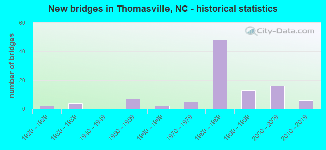
- New bridges - historical statistics
- 21920-1929
- 41930-1939
- 71950-1959
- 21960-1969
- 51970-1979
- 481980-1989
- 131990-1999
- 162000-2009
- 62010-2019
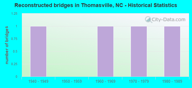
- Reconstructed bridges - Historical Statistics
- 11940-1949
- 01950-1959
- 11960-1969
- 11970-1979
- 11980-1989
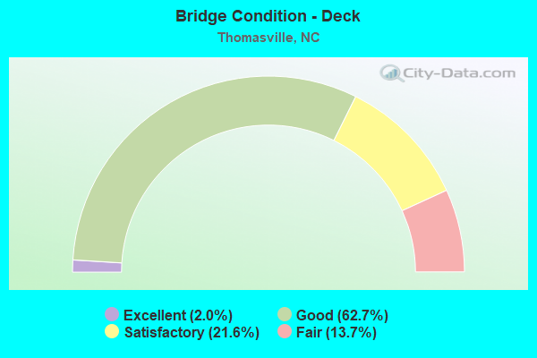
- Bridge Condition - Deck
- 2.0%Excellent
- 62.7%Good
- 21.6%Satisfactory
- 13.7%Fair
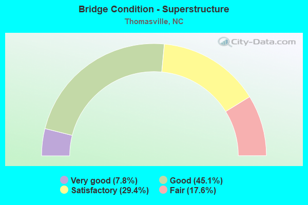
- Bridge Condition - Superstructure
- 7.8%Very good
- 45.1%Good
- 29.4%Satisfactory
- 17.6%Fair

- Bridge Condition - Substructure
- 2.0%Excellent
- 5.9%Very good
- 52.9%Good
- 25.5%Satisfactory
- 9.8%Fair
- 3.9%Poor
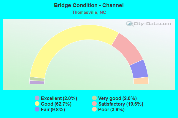
- Bridge Condition - Channel
- 2.0%Excellent
- 2.0%Very good
- 62.7%Good
- 19.6%Satisfactory
- 9.8%Fair
- 3.9%Poor
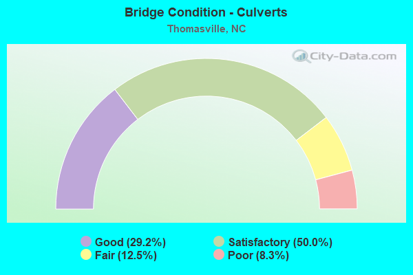
- Bridge Condition - Culverts
- 29.2%Good
- 50.0%Satisfactory
- 12.5%Fair
- 8.3%Poor
Find on map >> Show street view
Structure Number: 570493, Location: 0.4 MI.N.JCT.SR2183 (Lat: 35.859803, Lng: -80.083719), Route carried "under" structure: City street , Year Built: 1981, Structure Length: 0. m, Average Daily Traffic: 550 (year 2017), Truck Traffic: 7%, Features Intersected: I85N, Facility Carried by Structure: SR2132
Minimum Vertical Clearance: 5.63m (18.47ft), Kilometerpoint: 31.333, Lanes on structure: 3, Lanes under structure: 2, Material/Design: Steel, Design/Construction: Stringer/Multi-beam, Length of Maximum Span: 21.9m (71.9ft)
Find on map >> Show street view
Structure Number: 570494, Location: 0.4 MI. N. JCT. SR2183 (Lat: 35.859986, Lng: -80.084033), Route carried "under" structure: City street , Year Built: 1981, Structure Length: 0. m, Average Daily Traffic: 550 (year 2015), Truck Traffic: 7%, Features Intersected: I85S, Facility Carried by Structure: SR2132
Minimum Vertical Clearance: 7.05m (23.13ft), Kilometerpoint: 31.333, Lanes on structure: 3, Lanes under structure: 2, Material/Design: Steel, Design/Construction: Stringer/Multi-beam, Length of Maximum Span: 21.9m (71.9ft)
Find on map >> Show street view
Structure Number: 570552, Location: 0.2 MI. N. JCT. SR2032 (Lat: 35.878408, Lng: -80.099356), Route carried "under" structure: State highway 3405, Year Built: 2005, Structure Length: 0. m, Average Daily Traffic: 2,900 (year 2017), Truck Traffic: 6%, Features Intersected: SR2085
Minimum Vertical Clearance: 6.32m (20.73ft), Kilometerpoint: 0.000, Lanes on structure: 2, Lanes under structure: 2, Material/Design: Steel continuous, Design/Construction: Stringer/Multi-beam, Length of Maximum Span: 42.3m (138.8ft)