Bridge Statistics for Thompson, New York (NY)
Condition, Traffic, Stress, Structural Evaluation, Project Costs
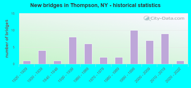
- New bridges - historical statistics
- 11920-1929
- 41930-1939
- 11940-1949
- 81950-1959
- 61960-1969
- 21970-1979
- 21980-1989
- 101990-1999
- 72000-2009
- 92010-2019
- 12020-2022
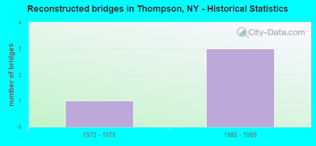
- Reconstructed bridges - Historical Statistics
- 11970-1979
- 31980-1989
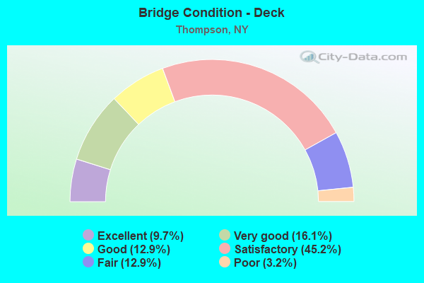
- Bridge Condition - Deck
- 9.7%Excellent
- 16.1%Very good
- 12.9%Good
- 45.2%Satisfactory
- 12.9%Fair
- 3.2%Poor
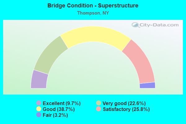
- Bridge Condition - Superstructure
- 9.7%Excellent
- 22.6%Very good
- 38.7%Good
- 25.8%Satisfactory
- 3.2%Fair
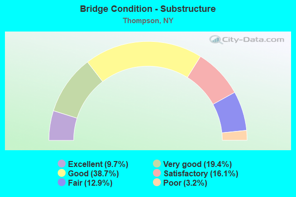
- Bridge Condition - Substructure
- 9.7%Excellent
- 19.4%Very good
- 38.7%Good
- 16.1%Satisfactory
- 12.9%Fair
- 3.2%Poor
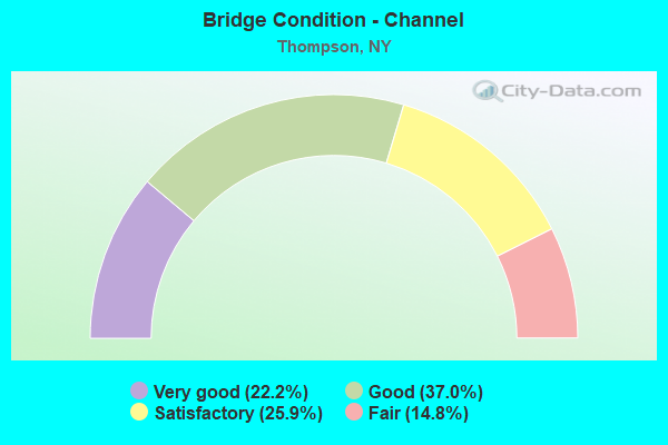
- Bridge Condition - Channel
- 22.2%Very good
- 37.0%Good
- 25.9%Satisfactory
- 14.8%Fair
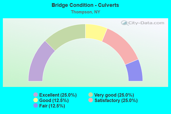
- Bridge Condition - Culverts
- 25.0%Excellent
- 25.0%Very good
- 12.5%Good
- 25.0%Satisfactory
- 12.5%Fair
Find on map >> Show street view
Structure Number: 101368, Location: AT EXIT 102 OF SH 17 (Lat: 41.717525, Lng: -74.729133), Route carried "on" structure: County highway , Year Built: 1960, Year Reconstructed: 1993, Status: Open, Structure Length: 8.99m (29.49ft), Average Daily Traffic: 2,198 (year 2017), Truck Traffic: 10%, Average Future Daily Traffic: 2,670 (year 2040), Design Load: HS 20, Features Intersected: 17 17 96091228 (EB), RT, Facility Carried by Structure: CR 174
Minimum Vertical Clearance: 30+ m (98+ ft), Kilometerpoint: 7.305, Lanes on structure: 2, Lanes under structure: 5, Owner: State Highway Agency, Approaching Roadway Width: 12.5m (41.0ft), Skew: 3 degrees, Material/Design: Steel continuous, Design/Construction: Stringer/Multi-beam, Number Of Spans In Main Unit: 4, Length of Maximum Span: 25.9m (85.0ft), Curb-To-Curb Width: 12.3m (40.4ft), Out-to-Out Width: 13.1m (43.0ft)
Condition: Deck: Satisfactory, Superstructure: Good, Substructure: Satisfactory, Operating Rating: 54.4 metric tons, Method Used To Determine Operating Rating: Load Factor (LF), Inventory Rating: 32.7 metric tons, Method Used To Determine Inventory Rating: Load Factor (LF), Structural Evaluation: Equal to present minimum criteria, Deck Geometry: Equal to present minimum criteria, Underclear: Meets minimum limits, Approach Roadway Alignment: Equal to present minimum criteria, Length Of Structure Improvement: 8.99m (29.49ft), Designated Inspection Frequency: Every 24 months, Inspection Date: July 2020, Bridge Improvement Cost: $2,643,000, Roadway Improvement Cost: $1,548,000, Total Project Cost: $4,191,000 ( Estimate for 2021), Deck Structure Type: Concrete Cast-file-Place, Wearing Surface/Protective System: Wearing Surface: Integral Concrete, Deck Protection: Epoxy Coated Reinforcing
Find on map >> Show street view
Structure Number: 1013691, Location: 35 MI NW JCT RTS 17 & 17B (Lat: 41.706625, Lng: -74.735864), Route carried "on" structure: State highway 17, Year Built: 1992, Status: Open, Structure Length: 3.23m (10.60ft), Average Daily Traffic: 8,218 (year 2020), Truck Traffic: 11%, Average Future Daily Traffic: 9,522 (year 2040), Design Load: HS 20, Features Intersected: BUSHVILLE ROAD -
Minimum Vertical Clearance: 30+ m (98+ ft), Kilometerpoint: 37.908, Lanes on structure: 2, Lanes under structure: 2, Base Highway Network: Yes, Owner: State Highway Agency, Approaching Roadway Width: 12.2m (40.0ft), Skew: 3 degrees, Material/Design: Prestressed concrete, Design/Construction: Box Beam or Girders - Multiple, Number Of Spans In Main Unit: 1, Length of Maximum Span: 30.4m (99.7ft), Curb-To-Curb Width: 12.3m (40.4ft), Out-to-Out Width: 13.2m (43.3ft)
Condition: Deck: Fair, Superstructure: Satisfactory, Substructure: Good, Operating Rating: 76.5 metric tons, Method Used To Determine Operating Rating: Load and Resistance Factor Rating (LRFR) rating reported by rating factor(RF) method using HL-93 loadings, Inventory Rating: 32.7 metric tons, Method Used To Determine Inventory Rating: Load and Resistance Factor Rating (LRFR) rating reported by rating factor(RF) method using HL-93 loadings, Structural Evaluation: Equal to present minimum criteria, Deck Geometry: Better than present minimum criteria, Underclear: Meets minimum limits, Approach Roadway Alignment: Equal to present desirable criteria, Length Of Structure Improvement: 3.23m (10.60ft), Designated Inspection Frequency: Every 24 months, Inspection Date: May 2021, Bridge Improvement Cost: $1,170,000, Roadway Improvement Cost: $685,000, Total Project Cost: $1,855,000 ( Estimate for 2021), Wearing Surface/Protective System: Wearing Surface: Monolithic Concrete
Find on map >> Show street view
Structure Number: 1013692, Location: 35 MI NW JCT RTS 17 & 17B (Lat: 41.706542, Lng: -74.736136), Route carried "on" structure: State highway 17, Year Built: 1992, Status: Open, Structure Length: 3.23m (10.60ft), Average Daily Traffic: 8,218 (year 2020), Truck Traffic: 11%, Average Future Daily Traffic: 9,522 (year 2040), Design Load: HS 20, Features Intersected: BUSHVILLE ROAD -
Minimum Vertical Clearance: 30+ m (98+ ft), Kilometerpoint: 37.908, Lanes on structure: 2, Lanes under structure: 2, Base Highway Network: Yes, Owner: State Highway Agency, Approaching Roadway Width: 12.2m (40.0ft), Skew: 3 degrees, Material/Design: Prestressed concrete, Design/Construction: Box Beam or Girders - Multiple, Number Of Spans In Main Unit: 1, Length of Maximum Span: 30.4m (99.7ft), Curb-To-Curb Width: 12.3m (40.4ft), Out-to-Out Width: 13.2m (43.3ft)
Condition: Deck: Fair, Superstructure: Good, Substructure: Good, Operating Rating: 76.1 metric tons, Method Used To Determine Operating Rating: Load and Resistance Factor Rating (LRFR) rating reported by rating factor(RF) method using HL-93 loadings, Inventory Rating: 32.7 metric tons, Method Used To Determine Inventory Rating: Load and Resistance Factor Rating (LRFR) rating reported by rating factor(RF) method using HL-93 loadings, Structural Evaluation: Better than present minimum criteria, Deck Geometry: Better than present minimum criteria, Underclear: Somewhat better than minimum adequacy, Approach Roadway Alignment: Equal to present desirable criteria, Length Of Structure Improvement: 3.23m (10.60ft), Designated Inspection Frequency: Every 24 months, Inspection Date: May 2021, Bridge Improvement Cost: $1,298,000, Roadway Improvement Cost: $760,000, Total Project Cost: $2,058,000 ( Estimate for 2021), Wearing Surface/Protective System: Wearing Surface: Monolithic Concrete
Find on map >> Show street view
Structure Number: 10137, Location: 3.4 MI NW JCT SH 17 & SH1 (Lat: 41.704686, Lng: -74.736317), Route carried "on" structure: State highway 17, Year Built: 1960, Status: Open, Structure Length: 1.19m (3.90ft), Average Daily Traffic: 16,435 (year 2020), Truck Traffic: 11%, Average Future Daily Traffic: 19,044 (year 2040), Design Load: H 20, Features Intersected: E BR MONGAUP RVR
Minimum Vertical Clearance: 30+ m (98+ ft), Kilometerpoint: 38.117, Lanes on structure: 4, Base Highway Network: Yes, Owner: State Highway Agency, Approaching Roadway Width: 27.4m (89.9ft), Skew: 21 degrees, Material/Design: Concrete, Design/Construction: Culvert, Number Of Spans In Main Unit: 2, Length of Maximum Span: 5.4m (17.7ft)
Condition: Channel: Satisfactory, Culverts: Fair, Structural Evaluation: Somewhat better than minimum adequacy, Waterway Adequacy: Superior to present desirable criteria, Approach Roadway Alignment: Equal to present desirable criteria, Length Of Structure Improvement: 1.18m (3.87ft), Designated Inspection Frequency: Every 24 months, Inspection Date: September 2020, Bridge Improvement Cost: $1,479,000, Roadway Improvement Cost: $866,000, Total Project Cost: $2,345,000 ( Estimate for 2021)
Find on map >> Show street view
Structure Number: 101371, Location: 28 MI NW JCT RTS 17 + 17B (Lat: 41.696114, Lng: -74.733594), Route carried "on" structure: City street , Year Built: 1960, Status: Open, Structure Length: 6.37m (20.90ft), Average Daily Traffic: 2,378 (year 2017), Truck Traffic: 7%, Average Future Daily Traffic: 3,329 (year 2037), Design Load: HS 20, Features Intersected: RTE 17, Facility Carried by Structure: RAPP ROAD
Minimum Vertical Clearance: 30+ m (98+ ft), Kilometerpoint: 1.979, Lanes on structure: 2, Lanes under structure: 5, Owner: State Highway Agency, Approaching Roadway Width: 6.1m (20.0ft), Material/Design: Steel, Design/Construction: Stringer/Multi-beam, Number Of Spans In Main Unit: 4, Length of Maximum Span: 17.6m (57.7ft), Curb or Sidewalk Widths: Left: 0.7m (2.3ft), Right: 0.7m (2.3ft), Curb-To-Curb Width: 7.9m (25.9ft), Out-to-Out Width: 10.1m (33.1ft)
Condition: Deck: Fair, Superstructure: Satisfactory, Substructure: Satisfactory, Operating Rating: 65.4 metric tons, Method Used To Determine Operating Rating: Load and Resistance Factor Rating (LRFR) rating reported by rating factor(RF) method using HL-93 loadings, Inventory Rating: 50.2 metric tons, Method Used To Determine Inventory Rating: Load and Resistance Factor Rating (LRFR) rating reported by rating factor(RF) method using HL-93 loadings, Structural Evaluation: Equal to present minimum criteria, Deck Geometry: High priority of corrective action, Underclear: Meets minimum limits, Approach Roadway Alignment: Better than present minimum criteria, Length Of Structure Improvement: 6.37m (20.90ft), Designated Inspection Frequency: Every 24 months, Inspection Date: April 2021, Bridge Improvement Cost: $1,413,000, Roadway Improvement Cost: $827,000, Total Project Cost: $2,240,000 ( Estimate for 2021), Deck Structure Type: Concrete Cast-file-Place, Wearing Surface/Protective System: Wearing Surface: Bituminous, Membrane: Preformed Fabric
Find on map >> Show street view
Structure Number: 101372, Location: 20 MI NW JCT RTS 17 + 17B (Lat: 41.685008, Lng: -74.722258), Route carried "on" structure: State highway 17, Year Built: 1957, Status: Open, Structure Length: 0.85m (2.79ft), Average Daily Traffic: 16,435 (year 2020), Truck Traffic: 11%, Average Future Daily Traffic: 19,044 (year 2040), Design Load: H 20, Features Intersected: KINNE BROOK
Minimum Vertical Clearance: 30+ m (98+ ft), Kilometerpoint: 40.676, Lanes on structure: 4, Base Highway Network: Yes, Owner: State Highway Agency, Approaching Roadway Width: 23.8m (78.1ft), Skew: 23 degrees, Material/Design: Concrete continuous, Design/Construction: Culvert, Number Of Spans In Main Unit: 2, Length of Maximum Span: 3.7m (12.1ft)
Condition: Channel: Fair, Culverts: Satisfactory, Operating Rating: 97.2 metric tons, Method Used To Determine Operating Rating: Load and Resistance Factor Rating (LRFR) rating reported by rating factor(RF) method using HL-93 loadings, Inventory Rating: 87.8 metric tons, Method Used To Determine Inventory Rating: Load and Resistance Factor Rating (LRFR) rating reported by rating factor(RF) method using HL-93 loadings, Structural Evaluation: Equal to present minimum criteria, Waterway Adequacy: Equal to present minimum criteria, Approach Roadway Alignment: Equal to present desirable criteria, Length Of Structure Improvement: 0.85m (2.79ft), Designated Inspection Frequency: Every 24 months, Inspection Date: May 2021, Bridge Improvement Cost: $359,000, Roadway Improvement Cost: $210,000, Total Project Cost: $569,000 ( Estimate for 2021)
Find on map >> Show street view
Structure Number: 101373, Location: JCT RTS 17 & 17B (Lat: 41.666242, Lng: -74.700836), Route carried "on" structure: State highway 17B, Year Built: 1993, Status: Open, Structure Length: 6.49m (21.29ft), Average Daily Traffic: 11,623 (year 2020), Truck Traffic: 9%, Average Future Daily Traffic: 14,119 (year 2040), Design Load: HS 20, Features Intersected: 17 17 96091272WB, RTE 1
Minimum Vertical Clearance: 30+ m (98+ ft), Kilometerpoint: 35.076, Lanes on structure: 3, Lanes under structure: 6, Base Highway Network: Yes, Owner: State Highway Agency, Approaching Roadway Width: 13.4m (44.0ft), Material/Design: Steel continuous, Design/Construction: Stringer/Multi-beam, Number Of Spans In Main Unit: 2, Length of Maximum Span: 34.4m (112.9ft), Curb-To-Curb Width: 13.2m (43.3ft), Out-to-Out Width: 14.2m (46.6ft)
Condition: Deck: Satisfactory, Superstructure: Good, Substructure: Good, Operating Rating: 70.6 metric tons, Method Used To Determine Operating Rating: Load and Resistance Factor Rating (LRFR) rating reported by rating factor(RF) method using HL-93 loadings, Inventory Rating: 54.4 metric tons, Method Used To Determine Inventory Rating: Load and Resistance Factor Rating (LRFR) rating reported by rating factor(RF) method using HL-93 loadings, Structural Evaluation: Better than present minimum criteria, Deck Geometry: Somewhat better than minimum adequacy, Underclear: Meets minimum limits, Approach Roadway Alignment: Equal to present desirable criteria, Length Of Structure Improvement: 6.49m (21.29ft), Designated Inspection Frequency: Every 24 months, Inspection Date: April 2021, Bridge Improvement Cost: $2,081,000, Roadway Improvement Cost: $1,219,000, Total Project Cost: $3,300,000 ( Estimate for 2021), Deck Structure Type: Concrete Cast-file-Place, Wearing Surface/Protective System: Wearing Surface: Integral Concrete, Deck Protection: Epoxy Coated Reinforcing
Find on map >> Show street view
Structure Number: 101375, Location: JCT RTS 17 & 42 (Lat: 41.662878, Lng: -74.677306), Route carried "on" structure: State highway 42, Year Built: 1998, Status: Open, Structure Length: 7.35m (24.11ft), Average Daily Traffic: 22,356 (year 2019), Truck Traffic: 5%, Average Future Daily Traffic: 27,158 (year 2040), Design Load: HS 25 or greater, Features Intersected: 17 17 96091285, RTE 17
Minimum Vertical Clearance: 30+ m (98+ ft), Kilometerpoint: 22.027, Lanes on structure: 4, Lanes under structure: 6, Base Highway Network: Yes, Owner: State Highway Agency, Approaching Roadway Width: 20.7m (67.9ft), Skew: 21 degrees, Material/Design: Steel continuous, Design/Construction: Stringer/Multi-beam, Number Of Spans In Main Unit: 2, Length of Maximum Span: 41.1m (134.8ft), Curb-To-Curb Width: 20.7m (67.9ft), Out-to-Out Width: 21.5m (70.5ft)
Condition: Deck: Satisfactory, Superstructure: Good, Substructure: Good, Operating Rating: 98.0 metric tons, Method Used To Determine Operating Rating: Load Factor (LF), Inventory Rating: 58.1 metric tons, Method Used To Determine Inventory Rating: Load Factor (LF), Structural Evaluation: Better than present minimum criteria, Deck Geometry: Superior to present desirable criteria, Underclear: Meets minimum limits, Approach Roadway Alignment: Equal to present desirable criteria, Length Of Structure Improvement: 7.34m (24.08ft), Designated Inspection Frequency: Every 24 months, Inspection Date: September 2020, Bridge Improvement Cost: $3,664,000, Roadway Improvement Cost: $2,146,000, Total Project Cost: $5,809,000 ( Estimate for 2021), Deck Structure Type: Concrete Cast-file-Place, Wearing Surface/Protective System: Wearing Surface: Integral Concrete, Deck Protection: Epoxy Coated Reinforcing
Find on map >> Show street view
Structure Number: 101377, Location: 2 mi SE JCT RTS 17 + 42 (Lat: 41.644200, Lng: -74.647931), Route carried "on" structure: County highway , Year Built: 2011, Status: Open, Structure Length: 7.62m (25.00ft), Average Daily Traffic: 2,946 (year 2017), Truck Traffic: 8%, Average Future Daily Traffic: 4,124 (year 2037), Design Load: HL 93, Features Intersected: 17 17 96091305 EB, RTE, Facility Carried by Structure: CR 173A
Minimum Vertical Clearance: 30+ m (98+ ft), Kilometerpoint: 0.113, Lanes on structure: 2, Lanes under structure: 5, Owner: State Highway Agency, Approaching Roadway Width: 12.0m (39.4ft), Skew: 2 degrees, Material/Design: Steel continuous, Design/Construction: Stringer/Multi-beam, Number Of Spans In Main Unit: 3, Length of Maximum Span: 29.9m (98.1ft), Curb-To-Curb Width: 12.0m (39.4ft), Out-to-Out Width: 13.3m (43.6ft)
Condition: Deck: Satisfactory, Superstructure: Very good, Substructure: Good, Operating Rating: 86.9 metric tons, Method Used To Determine Operating Rating: Field evaluation and documented engineering judgment, Inventory Rating: 40.8 metric tons, Method Used To Determine Inventory Rating: Field evaluation and documented engineering judgment, Structural Evaluation: Better than present minimum criteria, Deck Geometry: Somewhat better than minimum adequacy, Underclear: High priority of corrective action, Approach Roadway Alignment: Equal to present desirable criteria, Length Of Structure Improvement: 7.62m (25.00ft), Designated Inspection Frequency: Every 24 months, Inspection Date: July 2021, Bridge Improvement Cost: $2,668,000, Roadway Improvement Cost: $1,562,000, Total Project Cost: $4,231,000 ( Estimate for 2021), Deck Structure Type: Concrete Cast-file-Place, Wearing Surface/Protective System: Wearing Surface: Integral Concrete, Deck Protection: Epoxy Coated Reinforcing
Find on map >> Show street view
Structure Number: 101378, Location: 32 MI SE JCT RTS 17 + 42 (Lat: 41.638667, Lng: -74.627519), Route carried "on" structure: County highway , Year Built: 1957, Status: Open, Structure Length: 6.74m (22.11ft), Average Daily Traffic: 1,929 (year 2017), Truck Traffic: 15%, Average Future Daily Traffic: 2,386 (year 2040), Design Load: HS 20, Features Intersected: RTE 17, Facility Carried by Structure: CR 161
Minimum Vertical Clearance: 30+ m (98+ ft), Kilometerpoint: 0.225, Lanes on structure: 2, Lanes under structure: 7, Owner: State Highway Agency, Approaching Roadway Width: 11.0m (36.1ft), Skew: 20 degrees, Material/Design: Steel, Design/Construction: Stringer/Multi-beam, Number Of Spans In Main Unit: 4, Length of Maximum Span: 19.8m (65.0ft), Curb or Sidewalk Widths: Left: 0.9m (3.0ft), Right: 0.9m (3.0ft), Curb-To-Curb Width: 11.0m (36.1ft), Out-to-Out Width: 13.1m (43.0ft)
Condition: Deck: Fair, Superstructure: Fair, Substructure: Fair, Operating Rating: 61.6 metric tons, Method Used To Determine Operating Rating: Load and Resistance Factor Rating (LRFR) rating reported by rating factor(RF) method using HL-93 loadings, Inventory Rating: 47.3 metric tons, Method Used To Determine Inventory Rating: Load and Resistance Factor Rating (LRFR) rating reported by rating factor(RF) method using HL-93 loadings, Structural Evaluation: Somewhat better than minimum adequacy, Deck Geometry: Equal to present minimum criteria, Underclear: High priority of corrective action, Approach Roadway Alignment: Equal to present desirable criteria, Length Of Structure Improvement: 6.73m (22.08ft), Designated Inspection Frequency: Every 24 months, Inspection Date: April 2021, Bridge Improvement Cost: $1,904,000, Roadway Improvement Cost: $1,115,000, Total Project Cost: $3,019,000 ( Estimate for 2021), Deck Structure Type: Concrete Cast-file-Place, Wearing Surface/Protective System: Wearing Surface: Bituminous, Membrane: Other
Find on map >> Show street view
Structure Number: 1013801, Location: 4.1 MI SE JCT SH17 & SH42 (Lat: 41.625056, Lng: -74.598131), Route carried "on" structure: State highway 17, Year Built: 2000, Status: Open, Structure Length: 2.96m (9.71ft), Average Daily Traffic: 11,186 (year 2008), Truck Traffic: 10%, Average Future Daily Traffic: 12,962 (year 2040), Design Load: HS 25 or greater, Features Intersected: KATRINA FALLS RD
Minimum Vertical Clearance: 30+ m (98+ ft), Kilometerpoint: 53.596, Lanes on structure: 3, Lanes under structure: 2, Base Highway Network: Yes, Owner: State Highway Agency, Approaching Roadway Width: 18.0m (59.1ft), Skew: 1 degrees, Material/Design: Prestressed concrete, Design/Construction: Box Beam or Girders - Multiple, Number Of Spans In Main Unit: 1, Length of Maximum Span: 29.0m (95.1ft), Curb-To-Curb Width: 17.8m (58.4ft), Out-to-Out Width: 18.8m (61.7ft)
Condition: Deck: Satisfactory, Superstructure: Satisfactory, Substructure: Good, Operating Rating: 97.2 metric tons, Method Used To Determine Operating Rating: Load and Resistance Factor Rating (LRFR) rating reported by rating factor(RF) method using HL-93 loadings, Inventory Rating: 90.7 metric tons, Method Used To Determine Inventory Rating: Load and Resistance Factor Rating (LRFR) rating reported by rating factor(RF) method using HL-93 loadings, Structural Evaluation: Equal to present minimum criteria, Deck Geometry: Better than present minimum criteria, Underclear: Somewhat better than minimum adequacy, Approach Roadway Alignment: Equal to present desirable criteria, Length Of Structure Improvement: 2.95m (9.68ft), Designated Inspection Frequency: Every 24 months, Inspection Date: April 2021, Bridge Improvement Cost: $1,772,000, Roadway Improvement Cost: $1,038,000, Total Project Cost: $2,809,000 ( Estimate for 2021), Deck Structure Type: Concrete Cast-file-Place, Wearing Surface/Protective System: Wearing Surface: Monolithic Concrete, Deck Protection: Epoxy Coated Reinforcing
Find on map >> Show street view
Structure Number: 1013802, Location: 5.1 MI SE JCT SH17 & SH42 (Lat: 41.624886, Lng: -74.598325), Route carried "on" structure: State highway 17, Year Built: 2000, Status: Open, Structure Length: 2.96m (9.71ft), Average Daily Traffic: 11,186 (year 2008), Truck Traffic: 10%, Average Future Daily Traffic: 12,962 (year 2040), Design Load: HS 25 or greater, Features Intersected: KATRINA FALLS RD
Minimum Vertical Clearance: 30+ m (98+ ft), Kilometerpoint: 53.596, Lanes on structure: 4, Lanes under structure: 2, Base Highway Network: Yes, Owner: State Highway Agency, Approaching Roadway Width: 18.0m (59.1ft), Skew: 1 degrees, Material/Design: Prestressed concrete, Design/Construction: Box Beam or Girders - Multiple, Number Of Spans In Main Unit: 1, Length of Maximum Span: 29.0m (95.1ft), Curb-To-Curb Width: 17.8m (58.4ft), Out-to-Out Width: 18.8m (61.7ft)
Condition: Deck: Satisfactory, Superstructure: Good, Substructure: Good, Operating Rating: 97.2 metric tons, Method Used To Determine Operating Rating: Load and Resistance Factor Rating (LRFR) rating reported by rating factor(RF) method using HL-93 loadings, Inventory Rating: 87.5 metric tons, Method Used To Determine Inventory Rating: Load and Resistance Factor Rating (LRFR) rating reported by rating factor(RF) method using HL-93 loadings, Structural Evaluation: Better than present minimum criteria, Deck Geometry: Meets minimum limits, Underclear: Somewhat better than minimum adequacy, Approach Roadway Alignment: Equal to present desirable criteria, Length Of Structure Improvement: 2.95m (9.68ft), Designated Inspection Frequency: Every 24 months, Inspection Date: April 2021, Bridge Improvement Cost: $1,772,000, Roadway Improvement Cost: $1,038,000, Total Project Cost: $2,809,000 ( Estimate for 2021), Deck Structure Type: Concrete Cast-file-Place, Wearing Surface/Protective System: Wearing Surface: Monolithic Concrete, Deck Protection: Epoxy Coated Reinforcing
Find on map >> Show street view
Structure Number: 1013811, Location: 6.2 MI SE JCT RTS 17 & 42 (Lat: 41.616181, Lng: -74.576197), Route carried "on" structure: State highway 17, Year Built: 1956, Year Reconstructed: 1986, Status: Open, Structure Length: 1.58m (5.18ft), Average Daily Traffic: 11,186 (year 2008), Truck Traffic: 10%, Average Future Daily Traffic: 12,962 (year 2040), Design Load: HS 20, Features Intersected: WANAKSINK ROAD
Minimum Vertical Clearance: 30+ m (98+ ft), Kilometerpoint: 55.720, Lanes on structure: 2, Lanes under structure: 2, Base Highway Network: Yes, Owner: State Highway Agency, Approaching Roadway Width: 11.9m (39.0ft), Material/Design: Steel, Design/Construction: Stringer/Multi-beam, Number Of Spans In Main Unit: 1, Length of Maximum Span: 14.6m (47.9ft), Curb-To-Curb Width: 13.1m (43.0ft), Out-to-Out Width: 14.2m (46.6ft)
Condition: Deck: Good, Superstructure: Good, Substructure: Good, Operating Rating: 64.4 metric tons, Method Used To Determine Operating Rating: Load Factor (LF), Inventory Rating: 38.1 metric tons, Method Used To Determine Inventory Rating: Load Factor (LF), Structural Evaluation: Better than present minimum criteria, Deck Geometry: Superior to present desirable criteria, Underclear: Better than present minimum criteria, Approach Roadway Alignment: Equal to present desirable criteria, Length Of Structure Improvement: 1.58m (5.18ft), Designated Inspection Frequency: Every 24 months, Inspection Date: August 2020, Bridge Improvement Cost: $1,162,000, Roadway Improvement Cost: $680,000, Total Project Cost: $1,842,000 ( Estimate for 2021), Deck Structure Type: Concrete Cast-file-Place, Wearing Surface/Protective System: Wearing Surface: Integral Concrete, Deck Protection: Epoxy Coated Reinforcing
Find on map >> Show street view
Structure Number: 1013812, Location: 6.2 MI SE JCT RTS 17 & 42 (Lat: 41.616056, Lng: -74.576389), Route carried "on" structure: State highway 17, Year Built: 1956, Year Reconstructed: 1986, Status: Open, Structure Length: 1.58m (5.18ft), Average Daily Traffic: 11,186 (year 2008), Truck Traffic: 10%, Average Future Daily Traffic: 12,962 (year 2040), Design Load: HS 20, Features Intersected: WANAKSINK ROAD
Minimum Vertical Clearance: 30+ m (98+ ft), Kilometerpoint: 55.720, Lanes on structure: 3, Lanes under structure: 2, Base Highway Network: Yes, Owner: State Highway Agency, Approaching Roadway Width: 16.8m (55.1ft), Material/Design: Steel, Design/Construction: Stringer/Multi-beam, Number Of Spans In Main Unit: 1, Length of Maximum Span: 14.6m (47.9ft), Curb-To-Curb Width: 16.8m (55.1ft), Out-to-Out Width: 17.7m (58.1ft)
Condition: Deck: Good, Superstructure: Good, Substructure: Satisfactory, Operating Rating: 73.5 metric tons, Method Used To Determine Operating Rating: Load Factor (LF), Inventory Rating: 43.5 metric tons, Method Used To Determine Inventory Rating: Load Factor (LF), Structural Evaluation: Equal to present minimum criteria, Deck Geometry: Equal to present minimum criteria, Underclear: Equal to present minimum criteria, Approach Roadway Alignment: Equal to present desirable criteria, Length Of Structure Improvement: 1.58m (5.18ft), Designated Inspection Frequency: Every 24 months, Inspection Date: August 2020, Bridge Improvement Cost: $1,452,000, Roadway Improvement Cost: $850,000, Total Project Cost: $2,302,000 ( Estimate for 2021), Deck Structure Type: Concrete Cast-file-Place, Wearing Surface/Protective System: Wearing Surface: Integral Concrete, Deck Protection: Epoxy Coated Reinforcing
Find on map >> Show street view
Structure Number: 10142, Location: JCT RTE 17B + MONGAUP R (Lat: 41.667219, Lng: -74.781939), Route carried "on" structure: State highway 17, Year Built: 2020, Status: Open, Structure Length: 3.87m (12.70ft), Average Daily Traffic: 12,035 (year 2019), Truck Traffic: 14%, Average Future Daily Traffic: 14,620 (year 2040), Design Load: HL 93, Features Intersected: MONGAUP RIVER
Minimum Vertical Clearance: 32.69m (107.25ft), Kilometerpoint: 27.932, Lanes on structure: 2, Owner: State Highway Agency, Approaching Roadway Width: 14.6m (47.9ft), Skew: 2 degrees, Material/Design: Steel, Design/Construction: Stringer/Multi-beam, Number Of Spans In Main Unit: 1, Length of Maximum Span: 38.1m (125.0ft), Curb-To-Curb Width: 14.6m (47.9ft), Out-to-Out Width: 15.6m (51.2ft)
Condition: Deck: Excellent, Superstructure: Excellent, Substructure: Excellent, Channel: Very good, Operating Rating: 87.1 metric tons, Method Used To Determine Operating Rating: Load Factor (LF), Inventory Rating: 51.7 metric tons, Method Used To Determine Inventory Rating: Load Factor (LF), Structural Evaluation: Superior to present desirable criteria, Deck Geometry: Superior to present desirable criteria, Waterway Adequacy: Equal to present minimum criteria, Approach Roadway Alignment: Equal to present desirable criteria, Length Of Structure Improvement: 3.87m (12.70ft), Designated Inspection Frequency: Every 24 months, Inspection Date: December 2020, Bridge Improvement Cost: $1,697,000, Roadway Improvement Cost: $993,000, Total Project Cost: $2,690,000 ( Estimate for 2021), Deck Structure Type: Concrete Cast-file-Place, Wearing Surface/Protective System: Wearing Surface: Integral Concrete, Deck Protection: Epoxy Coated Reinforcing
Find on map >> Show street view
Structure Number: 101421, Location: 25 MI W JCT RTS 17B + 17 (Lat: 41.670733, Lng: -74.745683), Route carried "on" structure: State highway 17B, Year Built: 1957, Status: Open, Structure Length: 0.85m (2.79ft), Average Daily Traffic: 12,035 (year 2019), Truck Traffic: 14%, Average Future Daily Traffic: 14,620 (year 2040), Design Load: HS 25 or greater, Features Intersected: KINNE BROOK
Minimum Vertical Clearance: 30+ m (98+ ft), Kilometerpoint: 31.118, Lanes on structure: 2, Base Highway Network: Yes, Owner: State Highway Agency, Approaching Roadway Width: 11.9m (39.0ft), Material/Design: Aluminum, Iron, Design/Construction: Culvert, Number Of Spans In Main Unit: 2, Length of Maximum Span: 3.7m (12.1ft)
Condition: Channel: Fair, Culverts: Very good, Operating Rating: 75.1 metric tons, Method Used To Determine Operating Rating: Field evaluation and documented engineering judgment, Inventory Rating: 40.8 metric tons, Method Used To Determine Inventory Rating: Field evaluation and documented engineering judgment, Structural Evaluation: Equal to present desirable criteria, Waterway Adequacy: Meets minimum limits, Approach Roadway Alignment: Equal to present desirable criteria, Length Of Structure Improvement: 0.85m (2.79ft), Designated Inspection Frequency: Every 24 months, Inspection Date: March 2021, Bridge Improvement Cost: $180,000, Roadway Improvement Cost: $105,000, Total Project Cost: $285,000 ( Estimate for 2021)
Find on map >> Show street view
Structure Number: 1079201, Location: SH 17 & Neversink River (Lat: 41.636672, Lng: -74.618281), Route carried "on" structure: State highway 17, Year Built: 2013, Status: Open, Structure Length: 15.70m (51.51ft), Average Daily Traffic: 11,379 (year 2010), Truck Traffic: 10%, Average Future Daily Traffic: 13,185 (year 2040), Design Load: HL 93, Features Intersected: EDWARDS ISLAND RD, Never
Minimum Vertical Clearance: 99.90m (327.76ft), Kilometerpoint: 51.391, Lanes on structure: 3, Owner: State Highway Agency, Approaching Roadway Width: 16.2m (53.1ft), Material/Design: Steel continuous, Design/Construction: Stringer/Multi-beam, Number Of Spans In Main Unit: 3, Length of Maximum Span: 63.0m (206.7ft), Curb-To-Curb Width: 16.2m (53.1ft), Out-to-Out Width: 17.1m (56.1ft)
Condition: Deck: Satisfactory, Superstructure: Very good, Substructure: Very good, Channel: Very good, Operating Rating: 51.8 metric tons, Method Used To Determine Operating Rating: Load and Resistance Factor Rating (LRFR) rating reported by rating factor(RF) method using HL-93 loadings, Inventory Rating: 39.9 metric tons, Method Used To Determine Inventory Rating: Load and Resistance Factor Rating (LRFR) rating reported by rating factor(RF) method using HL-93 loadings, Structural Evaluation: Equal to present desirable criteria, Deck Geometry: Equal to present minimum criteria, Waterway Adequacy: Equal to present minimum criteria, Approach Roadway Alignment: Equal to present desirable criteria, Length Of Structure Improvement: 15.69m (51.48ft), Designated Inspection Frequency: Every 24 months, Inspection Date: June 2021, Bridge Improvement Cost: $6,007,000, Roadway Improvement Cost: $3,517,000, Total Project Cost: $9,524,000 ( Estimate for 2021), Deck Structure Type: Concrete Cast-file-Place, Wearing Surface/Protective System: Wearing Surface: Integral Concrete, Deck Protection: Epoxy Coated Reinforcing
Find on map >> Show street view
Structure Number: 1079202, Location: SH 17 & Neversink River (Lat: 41.636497, Lng: -74.618358), Route carried "on" structure: State highway 17, Year Built: 2014, Status: Open, Structure Length: 15.70m (51.51ft), Average Daily Traffic: 11,379 (year 2010), Truck Traffic: 10%, Average Future Daily Traffic: 13,185 (year 2040), Design Load: HL 93, Features Intersected: EDWARDS ISLAND RD, Never
Minimum Vertical Clearance: 99.90m (327.76ft), Kilometerpoint: 51.391, Lanes on structure: 3, Owner: State Highway Agency, Approaching Roadway Width: 16.2m (53.1ft), Material/Design: Steel continuous, Design/Construction: Stringer/Multi-beam, Number Of Spans In Main Unit: 3, Length of Maximum Span: 63.0m (206.7ft), Curb-To-Curb Width: 16.2m (53.1ft), Out-to-Out Width: 17.1m (56.1ft)
Condition: Deck: Satisfactory, Superstructure: Very good, Substructure: Very good, Channel: Very good, Operating Rating: 43.7 metric tons, Method Used To Determine Operating Rating: Load and Resistance Factor Rating (LRFR) rating reported by rating factor(RF) method using HL-93 loadings, Inventory Rating: 33.7 metric tons, Method Used To Determine Inventory Rating: Load and Resistance Factor Rating (LRFR) rating reported by rating factor(RF) method using HL-93 loadings, Structural Evaluation: Equal to present desirable criteria, Deck Geometry: Equal to present minimum criteria, Waterway Adequacy: Equal to present desirable criteria, Approach Roadway Alignment: Equal to present desirable criteria, Length Of Structure Improvement: 15.69m (51.48ft), Designated Inspection Frequency: Every 24 months, Critical Feature Inspection Frequency: Every 24 months, Inspection Date: June 2021, Critical Feature Inspection Date: June 2021, Bridge Improvement Cost: $5,996,000, Roadway Improvement Cost: $3,511,000, Total Project Cost: $9,507,000 ( Estimate for 2021), Deck Structure Type: Concrete Cast-file-Place, Wearing Surface/Protective System: Wearing Surface: Integral Concrete, Deck Protection: Epoxy Coated Reinforcing
Find on map >> Show street view
Structure Number: 225693, Location: 2.5 MI N OF MONTICELLO (Lat: 41.684375, Lng: -74.722375), Route carried "on" structure: ServiceOther road , Year Built: 1960, Status: Open, Structure Length: 1.13m (3.71ft), Average Daily Traffic: 1,257 (year 2017), Truck Traffic: 5%, Average Future Daily Traffic: 1,760 (year 2037), Features Intersected: KINNE BROOK, Facility Carried by Structure: BENMOSCHE ROAD
Minimum Vertical Clearance: 30+ m (98+ ft), Kilometerpoint: 1.657, Lanes on structure: 2, Owner: County Highway Agency, Approaching Roadway Width: 10.4m (34.1ft), Material/Design: Steel, Design/Construction: Culvert, Number Of Spans In Main Unit: 2, Length of Maximum Span: 4.5m (14.8ft)
Condition: Channel: Very good, Culverts: Satisfactory, Operating Rating: 75.5 metric tons, Method Used To Determine Operating Rating: Field evaluation and documented engineering judgment, Inventory Rating: 29.4 metric tons, Method Used To Determine Inventory Rating: Field evaluation and documented engineering judgment, Structural Evaluation: Equal to present minimum criteria, Waterway Adequacy: Somewhat better than minimum adequacy, Approach Roadway Alignment: Superior to present desirable criteria, Length Of Structure Improvement: 1.12m (3.67ft), Designated Inspection Frequency: Every 24 months, Inspection Date: May 2021, Bridge Improvement Cost: $207,000, Roadway Improvement Cost: $121,000, Total Project Cost: $328,000 ( Estimate for 2021)
Find on map >> Show street view
Structure Number: 226854, Location: .5 MI W JCT SH42 & CR 109 (Lat: 41.681525, Lng: -74.675064), Route carried "on" structure: Other road , Year Built: 2002, Status: Open, Structure Length: 1.16m (3.81ft), Truck Traffic: 7%, Design Load: HS 25 or greater, Features Intersected: BAILEY LK OUTLET, Facility Carried by Structure: TH 142 MEDALLION
Minimum Vertical Clearance: 30+ m (98+ ft), Kilometerpoint: 0.097, Lanes on structure: 2, Owner: County Highway Agency, Approaching Roadway Width: 6.1m (20.0ft), Skew: 3 degrees, Material/Design: Prestressed concrete, Design/Construction: Box Beam or Girders - Multiple, Number Of Spans In Main Unit: 1, Length of Maximum Span: 11.0m (36.1ft), Curb-To-Curb Width: 6.8m (22.3ft), Out-to-Out Width: 7.4m (24.3ft)
Condition: Deck: Very good, Superstructure: Good, Substructure: Very good, Channel: Good, Operating Rating: 88.9 metric tons, Method Used To Determine Operating Rating: Load Factor (LF), Inventory Rating: 52.6 metric tons, Method Used To Determine Inventory Rating: Load Factor (LF), Structural Evaluation: Better than present minimum criteria, Deck Geometry: Somewhat better than minimum adequacy, Waterway Adequacy: Equal to present desirable criteria, Approach Roadway Alignment: Equal to present desirable criteria, Length Of Structure Improvement: 1.15m (3.77ft), Designated Inspection Frequency: Every 24 months, Inspection Date: March 2020, Bridge Improvement Cost: $285,000, Roadway Improvement Cost: $167,000, Total Project Cost: $453,000 ( Estimate for 2021), Wearing Surface/Protective System: Wearing Surface: Bituminous
Find on map >> Show street view
Structure Number: 2271371, Location: 0.24 mi N Jct Joyland Rd (Lat: 41.647436, Lng: -74.650522), Route carried "on" structure: Business Other road , Year Built: 2017, Status: Open, Structure Length: 0.82m (2.69ft), Design Load: HL 93, Features Intersected: UNKNOWN STREAM, Facility Carried by Structure: RESORTS WORLD DRIV
Minimum Vertical Clearance: 32.69m (107.25ft), Kilometerpoint: 0.644, Lanes on structure: 2, Owner: Town or Township Highway Agency, Approaching Roadway Width: 7.0m (23.0ft), Material/Design: Concrete, Design/Construction: Culvert, Number Of Spans In Main Unit: 1, Length of Maximum Span: 7.9m (25.9ft)
Condition: Channel: Good, Culverts: Excellent, Operating Rating: 78.2 metric tons, Method Used To Determine Operating Rating: Field evaluation and documented engineering judgment, Inventory Rating: 40.8 metric tons, Method Used To Determine Inventory Rating: Field evaluation and documented engineering judgment, Structural Evaluation: Superior to present desirable criteria, Waterway Adequacy: Superior to present desirable criteria, Approach Roadway Alignment: Equal to present desirable criteria, Length Of Structure Improvement: 0.82m (2.69ft), Designated Inspection Frequency: Every 24 months, Inspection Date: November 2020, Bridge Improvement Cost: $102,000, Roadway Improvement Cost: $60,000, Total Project Cost: $162,000 ( Estimate for 2021)
Find on map >> Show street view
Structure Number: 2271372, Location: 0.24 mi N Jct Joyland Rd (Lat: 41.647647, Lng: -74.650475), Route carried "on" structure: Business Other road , Year Built: 2017, Status: Open, Structure Length: 0.82m (2.69ft), Design Load: HL 93, Features Intersected: UNKNOWN STREAM, Facility Carried by Structure: RESORTS WORLD DRIV
Minimum Vertical Clearance: 32.69m (107.25ft), Kilometerpoint: 0.660, Lanes on structure: 2, Owner: Town or Township Highway Agency, Approaching Roadway Width: 7.0m (23.0ft), Material/Design: Concrete, Design/Construction: Culvert, Number Of Spans In Main Unit: 1, Length of Maximum Span: 7.9m (25.9ft)
Condition: Channel: Good, Culverts: Excellent, Operating Rating: 78.2 metric tons, Method Used To Determine Operating Rating: Field evaluation and documented engineering judgment, Inventory Rating: 40.8 metric tons, Method Used To Determine Inventory Rating: Field evaluation and documented engineering judgment, Structural Evaluation: Superior to present desirable criteria, Waterway Adequacy: Superior to present desirable criteria, Approach Roadway Alignment: Equal to present desirable criteria, Length Of Structure Improvement: 0.82m (2.69ft), Designated Inspection Frequency: Every 24 months, Inspection Date: November 2020, Bridge Improvement Cost: $102,000, Roadway Improvement Cost: $60,000, Total Project Cost: $162,000 ( Estimate for 2021)
Find on map >> Show street view
Structure Number: 2271381, Location: 1 mi N Jct Joyland Rd (Lat: 41.656214, Lng: -74.650525), Route carried "on" structure: Business Other road , Year Built: 2017, Status: Open, Structure Length: 1.89m (6.20ft), Design Load: HL 93, Features Intersected: TRIB TANNERY BROOK, Facility Carried by Structure: RESORTS WORLD DRIV
Minimum Vertical Clearance: 32.69m (107.25ft), Kilometerpoint: 1.947, Lanes on structure: 2, Owner: Town or Township Highway Agency, Approaching Roadway Width: 7.0m (23.0ft), Material/Design: Steel, Design/Construction: Stringer/Multi-beam, Number Of Spans In Main Unit: 1, Length of Maximum Span: 18.3m (60.0ft), Curb or Sidewalk Widths: Left: 1.8m (5.9ft), Right: 0.0m, Curb-To-Curb Width: 9.1m (29.9ft), Out-to-Out Width: 11.9m (39.0ft)
Condition: Deck: Excellent, Superstructure: Excellent, Substructure: Excellent, Channel: Good, Operating Rating: 49.9 metric tons, Method Used To Determine Operating Rating: Load Factor (LF), Inventory Rating: 29.9 metric tons, Method Used To Determine Inventory Rating: Load Factor (LF), Structural Evaluation: Better than present minimum criteria, Deck Geometry: Meets minimum limits, Waterway Adequacy: Better than present minimum criteria, Approach Roadway Alignment: Equal to present desirable criteria, Length Of Structure Improvement: 1.88m (6.17ft), Designated Inspection Frequency: Every 24 months, Inspection Date: November 2020, Bridge Improvement Cost: $803,000, Roadway Improvement Cost: $470,000, Total Project Cost: $1,273,000 ( Estimate for 2021), Deck Structure Type: Concrete Cast-file-Place, Wearing Surface/Protective System: Wearing Surface: Integral Concrete, Deck Protection: Epoxy Coated Reinforcing
Find on map >> Show street view
Structure Number: 2271382, Location: 1 mi N Jct Joyland Rd (Lat: 41.656067, Lng: -74.650406), Route carried "on" structure: Business Other road , Year Built: 2017, Status: Open, Structure Length: 1.89m (6.20ft), Design Load: HL 93, Features Intersected: TRIB TANNERY BROOK, Facility Carried by Structure: RESORTS WORLD DRIV
Minimum Vertical Clearance: 32.69m (107.25ft), Kilometerpoint: 1.963, Lanes on structure: 2, Owner: Town or Township Highway Agency, Approaching Roadway Width: 7.0m (23.0ft), Material/Design: Steel, Design/Construction: Stringer/Multi-beam, Number Of Spans In Main Unit: 1, Length of Maximum Span: 18.3m (60.0ft), Curb or Sidewalk Widths: Left: 0.0m, Right: 1.8m (5.9ft), Curb-To-Curb Width: 9.1m (29.9ft), Out-to-Out Width: 11.9m (39.0ft)
Condition: Deck: Excellent, Superstructure: Excellent, Substructure: Excellent, Channel: Good, Operating Rating: 49.9 metric tons, Method Used To Determine Operating Rating: Load Factor (LF), Inventory Rating: 29.9 metric tons, Method Used To Determine Inventory Rating: Load Factor (LF), Structural Evaluation: Better than present minimum criteria, Deck Geometry: Meets minimum limits, Waterway Adequacy: Better than present minimum criteria, Approach Roadway Alignment: Equal to present desirable criteria, Length Of Structure Improvement: 1.88m (6.17ft), Designated Inspection Frequency: Every 24 months, Inspection Date: November 2020, Bridge Improvement Cost: $760,000, Roadway Improvement Cost: $445,000, Total Project Cost: $1,204,000 ( Estimate for 2021), Deck Structure Type: Concrete Cast-file-Place, Wearing Surface/Protective System: Wearing Surface: Integral Concrete, Deck Protection: Epoxy Coated Reinforcing
Find on map >> Show street view
Structure Number: 335565, Location: 0.3 MI S GLEN WILD (Lat: 41.652594, Lng: -74.587717), Route carried "on" structure: County highway , Year Built: 1941, Status: Open, Structure Length: 0.82m (2.69ft), Average Daily Traffic: 4,212 (year 2020), Truck Traffic: 7%, Average Future Daily Traffic: 4,393 (year 2040), Features Intersected: FOWLWOOD BROOK, Facility Carried by Structure: GLEN WILD ROAD
Minimum Vertical Clearance: 30+ m (98+ ft), Kilometerpoint: 3.186, Lanes on structure: 2, Owner: County Highway Agency, Approaching Roadway Width: 10.4m (34.1ft), Material/Design: Prestressed concrete, Design/Construction: Box Beam or Girders - Multiple, Number Of Spans In Main Unit: 1, Length of Maximum Span: 7.6m (24.9ft), Curb-To-Curb Width: 9.8m (32.2ft), Out-to-Out Width: 10.4m (34.1ft)
Condition: Deck: Very good, Superstructure: Very good, Substructure: Satisfactory, Channel: Good, Inventory Rating: 78.0 metric tons, Method Used To Determine Inventory Rating: Load Factor (LF), Structural Evaluation: Equal to present minimum criteria, Deck Geometry: Meets minimum limits, Waterway Adequacy: Meets minimum limits, Approach Roadway Alignment: Equal to present desirable criteria, Length Of Structure Improvement: 0.82m (2.69ft), Designated Inspection Frequency: Every 24 months, Inspection Date: May 2021, Bridge Improvement Cost: $457,000, Roadway Improvement Cost: $268,000, Total Project Cost: $725,000 ( Estimate for 2021), Wearing Surface/Protective System: Wearing Surface: Bituminous
Find on map >> Show street view
Structure Number: 335571, Location: .9 MILE SW OF HARRIS (Lat: 41.707589, Lng: -74.740989), Route carried "on" structure: County highway , Year Built: 1935, Status: Open, Structure Length: 1.43m (4.69ft), Average Daily Traffic: 917 (year 2020), Truck Traffic: 6%, Average Future Daily Traffic: 1,284 (year 2040), Features Intersected: MID MONGAUP RIVER, Facility Carried by Structure: COUNTY ROAD 75
Minimum Vertical Clearance: 30+ m (98+ ft), Kilometerpoint: 2.462, Lanes on structure: 2, Owner: County Highway Agency, Approaching Roadway Width: 8.5m (27.9ft), Skew: 3 degrees, Material/Design: Steel, Design/Construction: Stringer/Multi-beam, Number Of Spans In Main Unit: 1, Length of Maximum Span: 14.0m (45.9ft), Curb-To-Curb Width: 8.1m (26.6ft), Out-to-Out Width: 8.6m (28.2ft)
Condition: Deck: Poor, Superstructure: Satisfactory, Substructure: Fair, Channel: Good, Operating Rating: 56.2 metric tons, Method Used To Determine Operating Rating: Load Factor (LF), Inventory Rating: 33.6 metric tons, Method Used To Determine Inventory Rating: Load Factor (LF), Structural Evaluation: Somewhat better than minimum adequacy, Deck Geometry: Somewhat better than minimum adequacy, Waterway Adequacy: Meets minimum limits, Approach Roadway Alignment: Equal to present desirable criteria, Length Of Structure Improvement: 1.43m (4.69ft), Designated Inspection Frequency: Every 24 months, Inspection Date: June 2021, Bridge Improvement Cost: $435,000, Roadway Improvement Cost: $255,000, Total Project Cost: $690,000 ( Estimate for 2021), Deck Structure Type: Concrete Cast-file-Place, Wearing Surface/Protective System: Wearing Surface: Bituminous
Find on map >> Show street view
Structure Number: 335583, Location: .5 MILE N OF MONTICELLO (Lat: 41.667358, Lng: -74.676725), Route carried "on" structure: County highway , Year Built: 1970, Status: Open, Structure Length: 0.82m (2.69ft), Average Daily Traffic: 6,942 (year 2020), Truck Traffic: 3%, Average Future Daily Traffic: 8,589 (year 2040), Features Intersected: OUT STACKHOUSE PD, Facility Carried by Structure: ANAWANNA LAKE RD
Minimum Vertical Clearance: 30+ m (98+ ft), Kilometerpoint: 0.145, Lanes on structure: 2, Owner: County Highway Agency, Approaching Roadway Width: 10.1m (33.1ft), Skew: 4 degrees, Material/Design: Concrete, Design/Construction: Culvert, Number Of Spans In Main Unit: 1, Length of Maximum Span: 7.9m (25.9ft), Curb-To-Curb Width: 17.0m (55.8ft), Out-to-Out Width: 18.2m (59.7ft)
Condition: Channel: Fair, Culverts: Good, Operating Rating: 77.7 metric tons, Method Used To Determine Operating Rating: Field evaluation and documented engineering judgment, Inventory Rating: 29.4 metric tons, Method Used To Determine Inventory Rating: Field evaluation and documented engineering judgment, Structural Evaluation: Better than present minimum criteria, Deck Geometry: Superior to present desirable criteria, Waterway Adequacy: Meets minimum limits, Approach Roadway Alignment: Superior to present desirable criteria, Length Of Structure Improvement: 0.82m (2.69ft), Designated Inspection Frequency: Every 24 months, Inspection Date: July 2021, Bridge Improvement Cost: $265,000, Roadway Improvement Cost: $155,000, Total Project Cost: $420,000 ( Estimate for 2021)
Find on map >> Show street view
Structure Number: 335617, Location: 2.5 MI N OF BRIDGEVILLE (Lat: 41.669858, Lng: -74.625417), Route carried "on" structure: County highway , Year Built: 1937, Status: Open, Structure Length: 1.34m (4.40ft), Average Daily Traffic: 5,129 (year 2020), Truck Traffic: 17%, Average Future Daily Traffic: 6,346 (year 2040), Features Intersected: KIAMESHA CREEK, Facility Carried by Structure: COUNTY ROAD 161
Minimum Vertical Clearance: 30+ m (98+ ft), Kilometerpoint: 4.055, Lanes on structure: 2, Owner: County Highway Agency, Approaching Roadway Width: 10.4m (34.1ft), Skew: 1 degrees, Material/Design: Steel, Design/Construction: Stringer/Multi-beam, Number Of Spans In Main Unit: 1, Length of Maximum Span: 12.4m (40.7ft), Curb-To-Curb Width: 10.4m (34.1ft), Out-to-Out Width: 11.4m (37.4ft)
Condition: Deck: Satisfactory, Superstructure: Satisfactory, Substructure: Fair, Channel: Good, Operating Rating: 44.5 metric tons, Method Used To Determine Operating Rating: Load Factor (LF), Inventory Rating: 26.3 metric tons, Method Used To Determine Inventory Rating: Load Factor (LF), Structural Evaluation: Somewhat better than minimum adequacy, Deck Geometry: Meets minimum limits, Waterway Adequacy: Somewhat better than minimum adequacy, Approach Roadway Alignment: Somewhat better than minimum adequacy, Length Of Structure Improvement: 1.34m (4.40ft), Designated Inspection Frequency: Every 24 months, Inspection Date: April 2021, Bridge Improvement Cost: $477,000, Roadway Improvement Cost: $279,000, Total Project Cost: $756,000 ( Estimate for 2021), Deck Structure Type: Concrete Cast-file-Place, Wearing Surface/Protective System: Wearing Surface: Bituminous
Find on map >> Show street view
Structure Number: 335622, Location: AT BRIDGEVILLE (Lat: 41.634183, Lng: -74.618853), Route carried "on" structure: County highway , Year Built: 1982, Status: Open, Structure Length: 4.94m (16.21ft), Average Daily Traffic: 821 (year 2017), Truck Traffic: 14%, Average Future Daily Traffic: 997 (year 2040), Features Intersected: NEVERSINK RIVER, Facility Carried by Structure: COUNTY ROAD 173
Minimum Vertical Clearance: 30+ m (98+ ft), Kilometerpoint: 4.891, Lanes on structure: 2, Owner: County Highway Agency, Approaching Roadway Width: 11.3m (37.1ft), Material/Design: Steel, Design/Construction: Stringer/Multi-beam, Number Of Spans In Main Unit: 1, Length of Maximum Span: 48.4m (158.8ft), Curb-To-Curb Width: 10.1m (33.1ft), Out-to-Out Width: 10.7m (35.1ft)
Condition: Deck: Satisfactory, Superstructure: Very good, Substructure: Good, Channel: Good, Inventory Rating: 71.7 metric tons, Method Used To Determine Inventory Rating: Load Factor (LF), Structural Evaluation: Better than present minimum criteria, Deck Geometry: Equal to present minimum criteria, Waterway Adequacy: Meets minimum limits, Approach Roadway Alignment: Equal to present desirable criteria, Length Of Structure Improvement: 4.93m (16.17ft), Designated Inspection Frequency: Every 24 months, Inspection Date: November 2021, Bridge Improvement Cost: $1,685,000, Roadway Improvement Cost: $987,000, Total Project Cost: $2,672,000 ( Estimate for 2021), Deck Structure Type: Concrete Cast-file-Place, Wearing Surface/Protective System: Wearing Surface: Integral Concrete, Deck Protection: Epoxy Coated Reinforcing
Find on map >> Show street view
Structure Number: 335623, Location: 1.7 MI NW OF MONTICELLO (Lat: 41.686303, Lng: -74.720986), Route carried "on" structure: County highway , Year Built: 1929, Year Reconstructed: 1984, Status: Open, Structure Length: 0.79m (2.59ft), Average Daily Traffic: 1,299 (year 2018), Truck Traffic: 6%, Average Future Daily Traffic: 1,578 (year 2040), Features Intersected: TRB MONGAUP RIVER, Facility Carried by Structure: COUNTY ROAD 174
Minimum Vertical Clearance: 30+ m (98+ ft), Kilometerpoint: 3.089, Lanes on structure: 2, Owner: County Highway Agency, Approaching Roadway Width: 11.6m (38.1ft), Skew: 3 degrees, Material/Design: Concrete, Design/Construction: Slab, Number Of Spans In Main Unit: 1, Length of Maximum Span: 7.3m (24.0ft), Curb-To-Curb Width: 11.1m (36.4ft), Out-to-Out Width: 12.2m (40.0ft)
Condition: Deck: Satisfactory, Superstructure: Satisfactory, Substructure: Fair, Channel: Satisfactory, Operating Rating: 72.6 metric tons, Method Used To Determine Operating Rating: Load Factor (LF), Inventory Rating: 43.5 metric tons, Method Used To Determine Inventory Rating: Load Factor (LF), Structural Evaluation: Somewhat better than minimum adequacy, Deck Geometry: Equal to present minimum criteria, Waterway Adequacy: Equal to present desirable criteria, Approach Roadway Alignment: Meets minimum limits, Length Of Structure Improvement: 0.79m (2.59ft), Designated Inspection Frequency: Every 24 months, Inspection Date: March 2020, Bridge Improvement Cost: $384,000, Roadway Improvement Cost: $225,000, Total Project Cost: $609,000 ( Estimate for 2021), Wearing Surface/Protective System: Wearing Surface: Bituminous
Find on map >> Show street view
Structure Number: 335624, Location: .6 MI SW OF HARRIS (Lat: 41.706583, Lng: -74.731958), Route carried "on" structure: County highway , Year Built: 1992, Status: Open, Structure Length: 2.99m (9.81ft), Average Daily Traffic: 2,615 (year 2018), Truck Traffic: 6%, Average Future Daily Traffic: 3,176 (year 2040), Design Load: HS 20, Features Intersected: EAST MONGAUP RVR, Facility Carried by Structure: COUNTY ROAD 174
Minimum Vertical Clearance: 30+ m (98+ ft), Kilometerpoint: 5.873, Lanes on structure: 2, Owner: County Highway Agency, Approaching Roadway Width: 10.4m (34.1ft), Skew: 4 degrees, Material/Design: Steel, Design/Construction: Stringer/Multi-beam, Number Of Spans In Main Unit: 1, Length of Maximum Span: 28.0m (91.9ft), Curb-To-Curb Width: 10.4m (34.1ft), Out-to-Out Width: 11.0m (36.1ft)
Condition: Deck: Good, Superstructure: Good, Substructure: Good, Channel: Satisfactory, Operating Rating: 65.3 metric tons, Method Used To Determine Operating Rating: Load Factor (LF), Inventory Rating: 32.7 metric tons, Method Used To Determine Inventory Rating: Load Factor (LF), Structural Evaluation: Better than present minimum criteria, Deck Geometry: Somewhat better than minimum adequacy, Waterway Adequacy: Meets minimum limits, Approach Roadway Alignment: Equal to present desirable criteria, Length Of Structure Improvement: 2.98m (9.78ft), Designated Inspection Frequency: Every 24 months, Inspection Date: November 2021, Bridge Improvement Cost: $985,000, Roadway Improvement Cost: $577,000, Total Project Cost: $1,562,000 ( Estimate for 2021), Deck Structure Type: Concrete Cast-file-Place, Wearing Surface/Protective System: Wearing Surface: Integral Concrete, Deck Protection: Epoxy Coated Reinforcing
Find on map >> Show street view
Structure Number: 335636, Location: 2.2 MI NE OF MONGAUP VLLY (Lat: 41.693106, Lng: -74.752297), Route carried "on" structure: Alternate Other road , Year Built: 2003, Status: Open, Structure Length: 1.58m (5.18ft), Average Daily Traffic: 135 (year 2017), Truck Traffic: 11%, Average Future Daily Traffic: 189 (year 2037), Design Load: HS 25 or greater, Features Intersected: MIDDL MONGAUP RVR, Facility Carried by Structure: KORTRIGHT ROAD
Minimum Vertical Clearance: 30+ m (98+ ft), Kilometerpoint: 0.000, Lanes on structure: 2, Owner: County Highway Agency, Approaching Roadway Width: 7.9m (25.9ft), Material/Design: Prestressed concrete, Design/Construction: Box Beam or Girders - Multiple, Number Of Spans In Main Unit: 1, Length of Maximum Span: 15.2m (49.9ft), Curb-To-Curb Width: 8.0m (26.2ft), Out-to-Out Width: 8.6m (28.2ft)
Condition: Deck: Very good, Superstructure: Very good, Substructure: Good, Channel: Satisfactory, Operating Rating: 76.2 metric tons, Method Used To Determine Operating Rating: Allowable Stress (AS), Inventory Rating: 45.4 metric tons, Method Used To Determine Inventory Rating: Allowable Stress (AS), Structural Evaluation: Better than present minimum criteria, Deck Geometry: Somewhat better than minimum adequacy, Waterway Adequacy: Somewhat better than minimum adequacy, Approach Roadway Alignment: Equal to present desirable criteria, Length Of Structure Improvement: 1.58m (5.18ft), Designated Inspection Frequency: Every 24 months, Inspection Date: August 2021, Bridge Improvement Cost: $506,000, Roadway Improvement Cost: $296,000, Total Project Cost: $802,000 ( Estimate for 2021), Wearing Surface/Protective System: Wearing Surface: Bituminous
Find on map >> Show street view
Structure Number: 335734, Location: .5 MILE SE OF HARRIS (Lat: 41.712275, Lng: -74.723519), Route carried "on" structure: County highway , Year Built: 1997, Status: Open, Structure Length: 1.22m (4.00ft), Average Daily Traffic: 550 (year 2017), Truck Traffic: 7%, Average Future Daily Traffic: 680 (year 2040), Features Intersected: E BR MONGAUP RVR, Facility Carried by Structure: HARRIS ROAD
Minimum Vertical Clearance: 30+ m (98+ ft), Kilometerpoint: 3.218, Lanes on structure: 2, Owner: County Highway Agency, Approaching Roadway Width: 7.6m (24.9ft), Skew: 1 degrees, Material/Design: Steel, Design/Construction: Stringer/Multi-beam, Number Of Spans In Main Unit: 1, Length of Maximum Span: 11.8m (38.7ft), Curb-To-Curb Width: 7.4m (24.3ft), Out-to-Out Width: 7.7m (25.3ft)
Condition: Deck: Very good, Superstructure: Good, Substructure: Good, Channel: Satisfactory, Operating Rating: 55.3 metric tons, Method Used To Determine Operating Rating: Load Factor (LF), Inventory Rating: 40.8 metric tons, Method Used To Determine Inventory Rating: Load Factor (LF), Structural Evaluation: Better than present minimum criteria, Deck Geometry: Meets minimum limits, Waterway Adequacy: Meets minimum limits, Approach Roadway Alignment: Equal to present desirable criteria, Length Of Structure Improvement: 1.21m (3.97ft), Designated Inspection Frequency: Every 24 months, Inspection Date: September 2021, Bridge Improvement Cost: $689,000, Roadway Improvement Cost: $403,000, Total Project Cost: $1,092,000 ( Estimate for 2021), Deck Structure Type: Wood or Timber, Wearing Surface/Protective System: Wearing Surface: Bituminous, Membrane: Other
Find on map >> Show street view
Structure Number: 335735, Location: 1.2 MILES SE OF KIAMESHA (Lat: 41.671719, Lng: -74.647639), Route carried "on" structure: Alternate Other road , Year Built: 2018, Status: Open, Structure Length: 2.13m (6.99ft), Average Daily Traffic: 225 (year 2013), Truck Traffic: 4%, Average Future Daily Traffic: 227 (year 2037), Design Load: HL 93, Features Intersected: KIAMESHA CREEK, Facility Carried by Structure: WORLD RESORTS DR
Minimum Vertical Clearance: 30+ m (98+ ft), Kilometerpoint: 0.000, Lanes on structure: 2, Owner: County Highway Agency, Approaching Roadway Width: 7.3m (24.0ft), Material/Design: Concrete, Design/Construction: Culvert, Number Of Spans In Main Unit: 1, Length of Maximum Span: 18.3m (60.0ft), Curb-To-Curb Width: 8.7m (28.5ft), Out-to-Out Width: 10.1m (33.1ft)
Condition: Channel: Good, Culverts: Very good, Operating Rating: 85.6 metric tons, Method Used To Determine Operating Rating: Field evaluation and documented engineering judgment, Inventory Rating: 40.8 metric tons, Method Used To Determine Inventory Rating: Field evaluation and documented engineering judgment, Structural Evaluation: Equal to present desirable criteria, Deck Geometry: Equal to present minimum criteria, Waterway Adequacy: Somewhat better than minimum adequacy, Approach Roadway Alignment: Equal to present desirable criteria, Length Of Structure Improvement: 2.13m (6.99ft), Designated Inspection Frequency: Every 24 months, Inspection Date: April 2021, Bridge Improvement Cost: $424,000, Roadway Improvement Cost: $249,000, Total Project Cost: $673,000 ( Estimate for 2021)
Find on map >> Show street view
Structure Number: 335736, Location: 2.9 MI S MONGAUP VALLEY (Lat: 41.633306, Lng: -74.775797), Route carried "on" structure: Alternate Other road , Year Built: 1936, Status: Open, Structure Length: 1.13m (3.71ft), Average Daily Traffic: 291 (year 2019), Truck Traffic: 5%, Average Future Daily Traffic: 407 (year 2039), Features Intersected: KINNE BROOK, Facility Carried by Structure: STARLIGHT ROAD
Minimum Vertical Clearance: 30+ m (98+ ft), Kilometerpoint: 3.636, Lanes on structure: 2, Owner: County Highway Agency, Approaching Roadway Width: 7.9m (25.9ft), Skew: 4 degrees, Material/Design: Steel, Design/Construction: Stringer/Multi-beam, Number Of Spans In Main Unit: 1, Length of Maximum Span: 10.3m (33.8ft), Curb-To-Curb Width: 6.2m (20.3ft), Out-to-Out Width: 7.0m (23.0ft)
Condition: Deck: Satisfactory, Superstructure: Satisfactory, Substructure: Poor, Channel: Satisfactory, Operating Rating: 45.4 metric tons, Method Used To Determine Operating Rating: Load Factor (LF), Inventory Rating: 27.2 metric tons, Method Used To Determine Inventory Rating: Load Factor (LF), Structural Evaluation: Meets minimum limits, Deck Geometry: Meets minimum limits, Waterway Adequacy: Meets minimum limits, Approach Roadway Alignment: Equal to present minimum criteria, Length Of Structure Improvement: 1.12m (3.67ft), Designated Inspection Frequency: Every 24 months, Inspection Date: June 2021, Bridge Improvement Cost: $401,000, Roadway Improvement Cost: $235,000, Total Project Cost: $636,000 ( Estimate for 2021), Deck Structure Type: Concrete Cast-file-Place, Wearing Surface/Protective System: Wearing Surface: Bituminous
Find on map >> Show street view
Structure Number: 335737, Location: 2.0 MI N OF BRIDGEVILLE (Lat: 41.667944, Lng: -74.623217), Route carried "on" structure: Spur Other road , Year Built: 1973, Status: Posted for load, Structure Length: 2.32m (7.61ft), Average Daily Traffic: 32 (year 2018), Average Future Daily Traffic: 45 (year 2038), Design Load: HS 20, Features Intersected: SHELDRAKE STREAM, Facility Carried by Structure: RIVER ROAD
Minimum Vertical Clearance: 30+ m (98+ ft), Kilometerpoint: 0.145, Lanes on structure: 1, Owner: County Highway Agency, Approaching Roadway Width: 6.1m (20.0ft), Skew: 2 degrees, Material/Design: Steel, Design/Construction: Stringer/Multi-beam, Number Of Spans In Main Unit: 1, Length of Maximum Span: 22.8m (74.8ft), Curb-To-Curb Width: 4.2m (13.8ft), Out-to-Out Width: 4.6m (15.1ft)
Condition: Deck: Satisfactory, Superstructure: Good, Substructure: Very good, Channel: Very good, Operating Rating: 64.4 metric tons, Method Used To Determine Operating Rating: Allowable Stress (AS), Inventory Rating: 48.1 metric tons, Method Used To Determine Inventory Rating: Allowable Stress (AS), Structural Evaluation: Better than present minimum criteria, Deck Geometry: Somewhat better than minimum adequacy, Waterway Adequacy: Equal to present desirable criteria, Approach Roadway Alignment: Superior to present desirable criteria, Bridge Posting: Required (Relationship of Operating Rating to Maximum Legal Load: > 39.9% below), Length Of Structure Improvement: 2.31m (7.58ft), Designated Inspection Frequency: Every 12 months, Inspection Date: March 2021, Bridge Improvement Cost: $339,000, Roadway Improvement Cost: $198,000, Total Project Cost: $537,000 ( Estimate for 2021), Deck Structure Type: Wood or Timber, Wearing Surface/Protective System: Wearing Surface: Bituminous
Find on map >> Show street view
Structure Number: 335738, Location: 1 MILE NW OF HARRIS (Lat: 41.726261, Lng: -74.746350), Route carried "on" structure: Other road , Year Built: 1933, Status: Open, Structure Length: 0.98m (3.22ft), Average Daily Traffic: 47 (year 2018), Truck Traffic: 9%, Average Future Daily Traffic: 66 (year 2038), Features Intersected: MID MONGAUP RIVER, Facility Carried by Structure: STRONG ROAD
Minimum Vertical Clearance: 30+ m (98+ ft), Kilometerpoint: 0.000, Lanes on structure: 1, Owner: County Highway Agency, Approaching Roadway Width: 5.5m (18.0ft), Material/Design: Steel, Design/Construction: Stringer/Multi-beam, Number Of Spans In Main Unit: 1, Length of Maximum Span: 7.9m (25.9ft), Curb-To-Curb Width: 3.9m (12.8ft), Out-to-Out Width: 4.2m (13.8ft)
Condition: Deck: Satisfactory, Superstructure: Satisfactory, Substructure: Satisfactory, Channel: Fair, Operating Rating: 59.9 metric tons, Method Used To Determine Operating Rating: Load Factor (LF), Inventory Rating: 45.4 metric tons, Method Used To Determine Inventory Rating: Load Factor (LF), Structural Evaluation: Equal to present minimum criteria, Deck Geometry: Meets minimum limits, Waterway Adequacy: Meets minimum limits, Approach Roadway Alignment: Equal to present minimum criteria, Length Of Structure Improvement: 0.97m (3.18ft), Designated Inspection Frequency: Every 24 months, Inspection Date: May 2021, Bridge Improvement Cost: $148,000, Roadway Improvement Cost: $87,000, Total Project Cost: $235,000 ( Estimate for 2021), Deck Structure Type: Wood or Timber, Wearing Surface/Protective System: Wearing Surface: Bituminous
Find on map >> Show street view
Structure Number: 336972, Location: 3 MI SW OF MONTICELLO (Lat: 41.614628, Lng: -74.748025), Route carried "on" structure: Bypass County highway , Year Built: 2000, Status: Open, Structure Length: 1.04m (3.41ft), Average Daily Traffic: 490 (year 2020), Truck Traffic: 5%, Average Future Daily Traffic: 494 (year 2040), Design Load: HS 25 or greater, Features Intersected: SACKETT LAKE OUTL, Facility Carried by Structure: COUNTY ROAD 45
Minimum Vertical Clearance: 30+ m (98+ ft), Kilometerpoint: 1.496, Lanes on structure: 2, Owner: County Highway Agency, Approaching Roadway Width: 9.8m (32.2ft), Material/Design: Concrete, Design/Construction: Frame, Number Of Spans In Main Unit: 1, Length of Maximum Span: 7.9m (25.9ft), Curb-To-Curb Width: 9.3m (30.5ft), Out-to-Out Width: 10.2m (33.5ft)
Condition: Deck: Very good, Superstructure: Good, Substructure: Very good, Channel: Very good, Inventory Rating: 60.8 metric tons, Method Used To Determine Inventory Rating: Load Factor (LF), Structural Evaluation: Better than present minimum criteria, Deck Geometry: Equal to present minimum criteria, Waterway Adequacy: Equal to present desirable criteria, Approach Roadway Alignment: Equal to present desirable criteria, Length Of Structure Improvement: 1.03m (3.38ft), Designated Inspection Frequency: Every 24 months, Inspection Date: March 2020, Bridge Improvement Cost: $297,000, Roadway Improvement Cost: $174,000, Total Project Cost: $472,000 ( Estimate for 2021), Wearing Surface/Protective System: Wearing Surface: Bituminous, Membrane: Other