Bridge Statistics for Thompson, New York (NY)
Condition, Traffic, Stress, Structural Evaluation, Project Costs
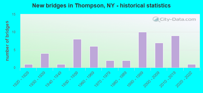
- New bridges - historical statistics
- 11920-1929
- 41930-1939
- 11940-1949
- 81950-1959
- 61960-1969
- 21970-1979
- 21980-1989
- 101990-1999
- 72000-2009
- 92010-2019
- 12020-2022
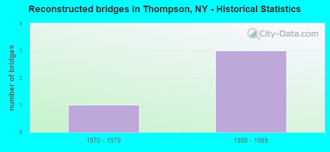
- Reconstructed bridges - Historical Statistics
- 11970-1979
- 31980-1989
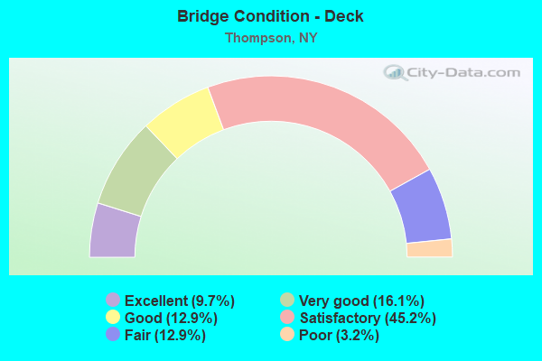
- Bridge Condition - Deck
- 9.7%Excellent
- 16.1%Very good
- 12.9%Good
- 45.2%Satisfactory
- 12.9%Fair
- 3.2%Poor
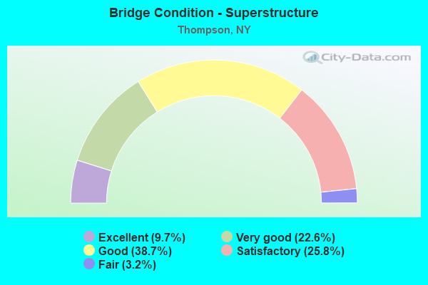
- Bridge Condition - Superstructure
- 9.7%Excellent
- 22.6%Very good
- 38.7%Good
- 25.8%Satisfactory
- 3.2%Fair
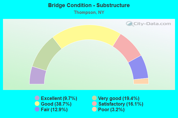
- Bridge Condition - Substructure
- 9.7%Excellent
- 19.4%Very good
- 38.7%Good
- 16.1%Satisfactory
- 12.9%Fair
- 3.2%Poor
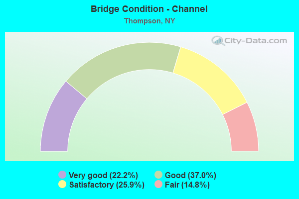
- Bridge Condition - Channel
- 22.2%Very good
- 37.0%Good
- 25.9%Satisfactory
- 14.8%Fair
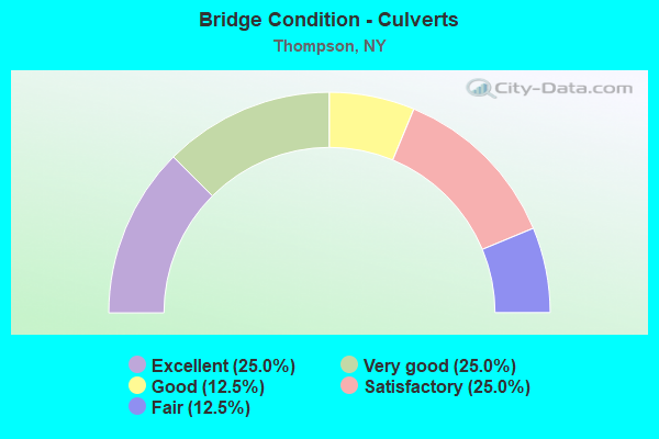
- Bridge Condition - Culverts
- 25.0%Excellent
- 25.0%Very good
- 12.5%Good
- 25.0%Satisfactory
- 12.5%Fair
Find on map >> Show street view
Structure Number: 552422, Location: 2.6 MI SO OF ROCK HILL (Lat: 41.588806, Lng: -74.604408), Route carried "on" structure: State lands road , Year Built: 1988, Status: Open, Structure Length: 1.22m (4.00ft), Average Daily Traffic: 189 (year 2017), Truck Traffic: 5%, Average Future Daily Traffic: 265 (year 2037), Design Load: HS 25 or greater, Features Intersected: WOLF BROOK, Facility Carried by Structure: WOLF BK ACCESS RO
Minimum Vertical Clearance: 30+ m (98+ ft), Kilometerpoint: 0.225, Lanes on structure: 1, Owner: State Agenciy, Approaching Roadway Width: 3.7m (12.1ft), Skew: 3 degrees, Material/Design: Prestressed concrete, Design/Construction: Box Beam or Girders - Multiple, Number Of Spans In Main Unit: 1, Length of Maximum Span: 11.8m (38.7ft), Curb-To-Curb Width: 5.0m (16.4ft), Out-to-Out Width: 5.6m (18.4ft)
Condition: Deck: Good, Superstructure: Very good, Substructure: Very good, Channel: Satisfactory, Operating Rating: 67.1 metric tons, Method Used To Determine Operating Rating: Load Factor (LF), Inventory Rating: 39.9 metric tons, Method Used To Determine Inventory Rating: Load Factor (LF), Structural Evaluation: Equal to present desirable criteria, Deck Geometry: High priority of replacement, Waterway Adequacy: Somewhat better than minimum adequacy, Approach Roadway Alignment: Equal to present minimum criteria, Length Of Structure Improvement: 1.21m (3.97ft), Designated Inspection Frequency: Every 24 months, Inspection Date: July 2021, Bridge Improvement Cost: $176,000, Roadway Improvement Cost: $103,000, Total Project Cost: $279,000 ( Estimate for 2021), Wearing Surface/Protective System: Wearing Surface: Bituminous
Find on map >> Show street view
Structure Number: 101368, Location: AT EXIT 102 OF SH 17 (Lat: 41.717525, Lng: -74.729133), Route carried "under" structure: State highway 17, Year Built: 1960, Structure Length: 0. m, Average Daily Traffic: 14,216 (year 1998), Features Intersected: 17 17 96091228 (EB), RT
Minimum Vertical Clearance: 4.83m (15.85ft), Kilometerpoint: 37.281, Lanes on structure: 2, Lanes under structure: 2, Material/Design: Steel continuous, Design/Construction: Stringer/Multi-beam, Length of Maximum Span: 25.9m (85.0ft)
Find on map >> Show street view
Structure Number: 1013691, Location: 35 MI NW JCT RTS 17 & 17B (Lat: 41.706625, Lng: -74.735864), Route carried "under" structure: County highway , Year Built: 1992, Structure Length: 0. m, Average Daily Traffic: 2,761 (year 1980), Features Intersected: BUSHVILLE ROAD -, Facility Carried by Structure: RTE 17
Minimum Vertical Clearance: 4.47m (14.67ft), Kilometerpoint: 0.000, Lanes on structure: 2, Lanes under structure: 2, Material/Design: Prestressed concrete, Design/Construction: Box Beam or Girders - Multiple, Length of Maximum Span: 30.4m (99.7ft)
Find on map >> Show street view
Structure Number: 1013692, Location: 35 MI NW JCT RTS 17 & 17B (Lat: 41.706542, Lng: -74.736136), Route carried "under" structure: County highway , Year Built: 1992, Structure Length: 0. m, Average Daily Traffic: 2,761 (year 1980), Features Intersected: BUSHVILLE ROAD -, Facility Carried by Structure: RTE 17
Minimum Vertical Clearance: 5.35m (17.55ft), Kilometerpoint: 0.000, Lanes on structure: 2, Lanes under structure: 2, Material/Design: Prestressed concrete, Design/Construction: Box Beam or Girders - Multiple, Length of Maximum Span: 30.4m (99.7ft)
Find on map >> Show street view
Structure Number: 101371, Location: 28 MI NW JCT RTS 17 + 17B (Lat: 41.696114, Lng: -74.733594), Route carried "under" structure: State highway 17, Year Built: 1960, Structure Length: 0. m, Average Daily Traffic: 14,216 (year 1998), Features Intersected: RTE 17, Facility Carried by Structure: RAPP ROAD
Minimum Vertical Clearance: 4.65m (15.26ft), Kilometerpoint: 39.839, Lanes on structure: 2, Lanes under structure: 5, Material/Design: Steel, Design/Construction: Stringer/Multi-beam, Length of Maximum Span: 17.6m (57.7ft)
Find on map >> Show street view
Structure Number: 101373, Location: JCT RTS 17 & 17B (Lat: 41.666242, Lng: -74.700836), Route carried "under" structure: State highway 17, Year Built: 1993, Structure Length: 0. m, Average Daily Traffic: 13,155 (year 1998), Features Intersected: 17 17 96091272WB, RTE 1
Minimum Vertical Clearance: 4.88m (16.01ft), Kilometerpoint: 43.491, Lanes on structure: 3, Lanes under structure: 3, Material/Design: Steel continuous, Design/Construction: Stringer/Multi-beam, Length of Maximum Span: 34.4m (112.9ft)
Find on map >> Show street view
Structure Number: 101375, Location: JCT RTS 17 & 42 (Lat: 41.662878, Lng: -74.677306), Route carried "under" structure: State highway 17, Year Built: 1998, Structure Length: 0. m, Average Daily Traffic: 27,857 (year 2011), Features Intersected: 17 17 96091285, RTE 17, Facility Carried by Structure: RTE 42
Minimum Vertical Clearance: 7.69m (25.23ft), Kilometerpoint: 45.857, Lanes on structure: 4, Lanes under structure: 3, Material/Design: Steel continuous, Design/Construction: Stringer/Multi-beam, Length of Maximum Span: 41.1m (134.8ft)
Find on map >> Show street view
Structure Number: 101377, Location: 2 mi SE JCT RTS 17 + 42 (Lat: 41.644200, Lng: -74.647931), Route carried "under" structure: State highway 17, Year Built: 2011, Structure Length: 0. m, Average Daily Traffic: 24,217 (year 1998), Features Intersected: 17 17 96091305 EB, RTE
Minimum Vertical Clearance: 5.89m (19.32ft), Kilometerpoint: 49.589, Lanes on structure: 2, Lanes under structure: 2, Material/Design: Steel continuous, Design/Construction: Stringer/Multi-beam, Length of Maximum Span: 29.9m (98.1ft)
Find on map >> Show street view
Structure Number: 101378, Location: 32 MI SE JCT RTS 17 + 42 (Lat: 41.638667, Lng: -74.627519), Route carried "under" structure: State highway 17, Year Built: 1957, Structure Length: 0. m, Average Daily Traffic: 22,487 (year 1998), Features Intersected: RTE 17, Facility Carried by Structure: CR 161
Minimum Vertical Clearance: 4.72m (15.49ft), Kilometerpoint: 51.424, Lanes on structure: 2, Lanes under structure: 7, Material/Design: Steel, Design/Construction: Stringer/Multi-beam, Length of Maximum Span: 19.8m (65.0ft)
Find on map >> Show street view
Structure Number: 1013801, Location: 4.1 MI SE JCT SH17 & SH42 (Lat: 41.625056, Lng: -74.598131), Route carried "under" structure: Bypass Other road , Year Built: 2000, Structure Length: 0. m, Features Intersected: KATRINA FALLS RD, Facility Carried by Structure: RTE 17
Minimum Vertical Clearance: 5.03m (16.50ft), Kilometerpoint: 5.487, Lanes on structure: 3, Lanes under structure: 2, Material/Design: Prestressed concrete, Design/Construction: Box Beam or Girders - Multiple, Length of Maximum Span: 29.0m (95.1ft)
Find on map >> Show street view
Structure Number: 1013802, Location: 5.1 MI SE JCT SH17 & SH42 (Lat: 41.624886, Lng: -74.598325), Route carried "under" structure: Other road , Year Built: 2000, Structure Length: 0. m, Average Daily Traffic: 1,000 (year 2000), Features Intersected: KATRINA FALLS RD, Facility Carried by Structure: RTE 17
Minimum Vertical Clearance: 4.35m (14.27ft), Kilometerpoint: 0.000, Lanes on structure: 4, Lanes under structure: 2, Material/Design: Prestressed concrete, Design/Construction: Box Beam or Girders - Multiple, Length of Maximum Span: 29.0m (95.1ft)
Find on map >> Show street view
Structure Number: 1013811, Location: 6.2 MI SE JCT RTS 17 & 42 (Lat: 41.616181, Lng: -74.576197), Route carried "under" structure: Other road , Year Built: 1956, Structure Length: 0. m, Features Intersected: WANAKSINK ROAD, Facility Carried by Structure: RTE 17
Minimum Vertical Clearance: 5.28m (17.32ft), Kilometerpoint: 0.000, Lanes on structure: 2, Lanes under structure: 2, Material/Design: Steel, Design/Construction: Stringer/Multi-beam, Length of Maximum Span: 14.6m (47.9ft)
Find on map >> Show street view
Structure Number: 1013812, Location: 6.2 MI SE JCT RTS 17 & 42 (Lat: 41.616056, Lng: -74.576389), Route carried "under" structure: Other road , Year Built: 1956, Structure Length: 0. m, Features Intersected: WANAKSINK ROAD, Facility Carried by Structure: RTE 17
Minimum Vertical Clearance: 4.59m (15.06ft), Kilometerpoint: 0.000, Lanes on structure: 3, Lanes under structure: 2, Material/Design: Steel, Design/Construction: Stringer/Multi-beam, Length of Maximum Span: 14.6m (47.9ft)