Bridge Statistics for Trenton, New Jersey (NJ)
Condition, Traffic, Stress, Structural Evaluation, Project Costs
- National Bridge Inventory (NBI) Statistics
- 124Number of bridges
- 1,608ft / 490mTotal length
- $105,652,000Total costs
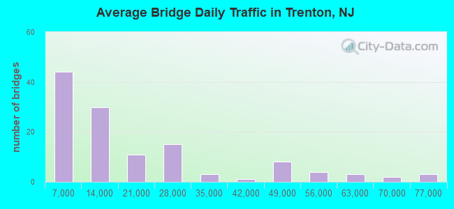
- 2,246,740Total average daily traffic
- 103,972Total average daily truck traffic
- National Bridge Inventory (NBI) Registered Bridges for Trenton
- No street view available for this location

- New bridges - historical statistics
- 5Before 1900
- 21900-1909
- 91910-1919
- 81920-1929
- 61930-1939
- 51940-1949
- 311950-1959
- 171960-1969
- 61970-1979
- 21980-1989
- 231990-1999
- 72000-2009
- 32010-2019
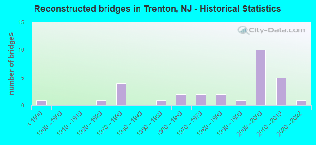
- Reconstructed bridges - Historical Statistics
- 1Before 1900
- 01900-1909
- 01910-1919
- 11920-1929
- 41930-1939
- 01940-1949
- 11950-1959
- 21960-1969
- 21970-1979
- 21980-1989
- 11990-1999
- 102000-2009
- 52010-2019
- 12020-2022
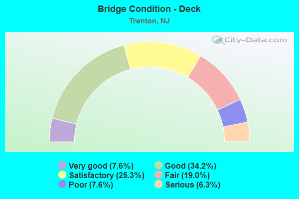
- Bridge Condition - Deck
- 7.6%Very good
- 34.2%Good
- 25.3%Satisfactory
- 19.0%Fair
- 7.6%Poor
- 6.3%Serious
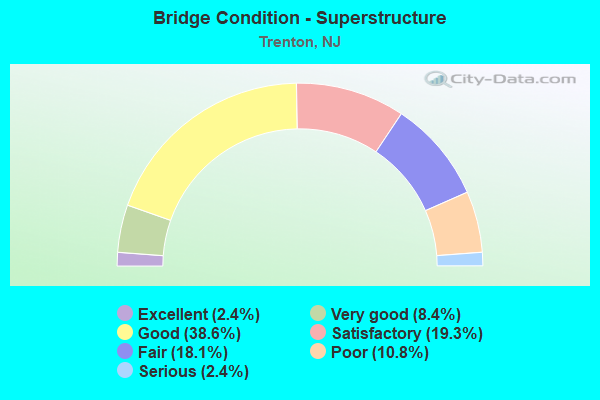
- Bridge Condition - Superstructure
- 2.4%Excellent
- 8.4%Very good
- 38.6%Good
- 19.3%Satisfactory
- 18.1%Fair
- 10.8%Poor
- 2.4%Serious
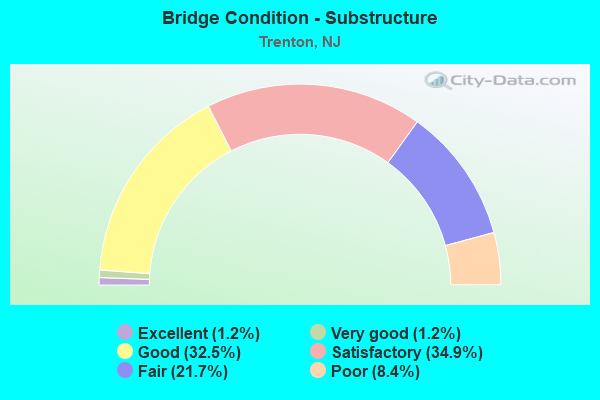
- Bridge Condition - Substructure
- 1.2%Excellent
- 1.2%Very good
- 32.5%Good
- 34.9%Satisfactory
- 21.7%Fair
- 8.4%Poor
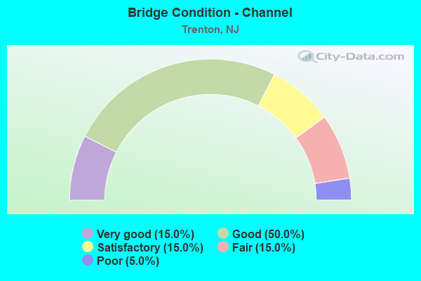
- Bridge Condition - Channel
- 15.0%Very good
- 50.0%Good
- 15.0%Satisfactory
- 15.0%Fair
- 5.0%Poor
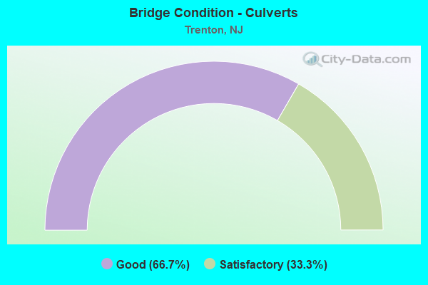
- Bridge Condition - Culverts
- 66.7%Good
- 33.3%Satisfactory
Find on map >> Show street view
Structure Number: 1131152, Location: 0.5 MI N OF US 1 JCT (Lat: 40.216231, Lng: -74.769161), Route carried "on" structure: State highway 29, Year Built: 1969, Status: Open, Structure Length: 2.41m (7.91ft), Average Daily Traffic: 46,350 (year 2020), Truck Traffic: 5%, Average Future Daily Traffic: 55,620 (year 2040), Design Load: HS 20+Mod, Features Intersected: RAMP 'D'
Minimum Vertical Clearance: 30+ m (98+ ft), Kilometerpoint: 6.180, Lanes on structure: 7, Lanes under structure: 1, Base Highway Network: Yes, Owner: State Highway Agency, Approaching Roadway Width: 29.9m (98.1ft), Skew: 30 degrees, Material/Design: Steel, Design/Construction: Stringer/Multi-beam, Number Of Spans In Main Unit: 1, Length of Maximum Span: 24.1m (79.1ft), Curb-To-Curb Width: 29.9m (98.1ft), Out-to-Out Width: 38.4m (126.0ft)
Condition: Deck: Satisfactory, Superstructure: Good, Substructure: Good, Operating Rating: 55.3 metric tons, Method Used To Determine Operating Rating: Load Factor (LF), Inventory Rating: 33.6 metric tons, Method Used To Determine Inventory Rating: Load Factor (LF), Structural Evaluation: Better than present minimum criteria, Deck Geometry: Meets minimum limits, Underclear: High priority of corrective action, Approach Roadway Alignment: Better than present minimum criteria, Length Of Structure Improvement: 2.41m (7.91ft), Designated Inspection Frequency: Every 24 months, Inspection Date: June 2020, Bridge Improvement Cost: $1,000, Total Project Cost: $1,000 ( Estimate for 2020), Deck Structure Type: Concrete Cast-file-Place, Wearing Surface/Protective System: Wearing Surface: Monolithic Concrete
Find on map >> Show street view
Structure Number: 1131153, Location: Adjacent to Str. 1131-154 (Lat: 40.217219, Lng: -74.769161), Route carried "on" structure: ServiceState highway 29, Year Built: 1969, Status: Open, Structure Length: 1.80m (5.91ft), Average Daily Traffic: 617 (year 2020), Truck Traffic: 1%, Average Future Daily Traffic: 753 (year 2040), Design Load: HS 20+Mod, Features Intersected: ASSUNPINK CREEK
Minimum Vertical Clearance: 30+ m (98+ ft), Kilometerpoint: 6.276, Lanes on structure: 2, Owner: State Highway Agency, Approaching Roadway Width: 9.1m (29.9ft), Material/Design: Steel, Design/Construction: Stringer/Multi-beam, Number Of Spans In Main Unit: 1, Length of Maximum Span: 16.5m (54.1ft), Curb or Sidewalk Widths: Left: 0.5m (1.6ft), Right: 1.8m (5.9ft), Curb-To-Curb Width: 9.1m (29.9ft), Out-to-Out Width: 12.3m (40.4ft)
Condition: Deck: Satisfactory, Superstructure: Good, Substructure: Good, Channel: Good, Operating Rating: 86.2 metric tons, Method Used To Determine Operating Rating: Load Factor (LF), Inventory Rating: 51.7 metric tons, Method Used To Determine Inventory Rating: Load Factor (LF), Structural Evaluation: Better than present minimum criteria, Deck Geometry: Equal to present minimum criteria, Waterway Adequacy: Better than present minimum criteria, Approach Roadway Alignment: Equal to present desirable criteria, Designated Inspection Frequency: Every 24 months, Underwater Inspection Frequency: Every 48 months, Inspection Date: July 2020, Underwater Inspection Date: August 2018, Deck Structure Type: Concrete Cast-file-Place, Wearing Surface/Protective System: Wearing Surface: Monolithic Concrete
Find on map >> Show street view
Structure Number: 1131154, Location: 0.6 MI NW OF 1-29 JCT (Lat: 40.217139, Lng: -74.769461), Route carried "on" structure: Ramp State highway 29, Year Built: 1969, Status: Open, Structure Length: 3.26m (10.70ft), Average Daily Traffic: 15,390 (year 2020), Truck Traffic: 5%, Average Future Daily Traffic: 18,779 (year 2040), Design Load: HS 20+Mod, Features Intersected: ASSUNPINK CREEK
Minimum Vertical Clearance: 30+ m (98+ ft), Kilometerpoint: 6.276, Lanes on structure: 1, Owner: State Highway Agency, Approaching Roadway Width: 6.7m (22.0ft), Skew: 1 degrees, Material/Design: Steel, Design/Construction: Stringer/Multi-beam, Number Of Spans In Main Unit: 1, Length of Maximum Span: 31.4m (103.0ft), Curb or Sidewalk Widths: Left: 0.0m, Right: 0.5m (1.6ft), Curb-To-Curb Width: 6.7m (22.0ft), Out-to-Out Width: 9.8m (32.2ft)
Condition: Deck: Satisfactory, Superstructure: Good, Substructure: Good, Channel: Very good, Operating Rating: 78.0 metric tons, Method Used To Determine Operating Rating: Load Factor (LF), Inventory Rating: 47.2 metric tons, Method Used To Determine Inventory Rating: Load Factor (LF), Structural Evaluation: Better than present minimum criteria, Deck Geometry: Equal to present minimum criteria, Waterway Adequacy: Equal to present desirable criteria, Approach Roadway Alignment: Equal to present desirable criteria, Designated Inspection Frequency: Every 24 months, Underwater Inspection Frequency: Every 48 months, Inspection Date: May 2020, Underwater Inspection Date: April 2020, Deck Structure Type: Concrete Cast-file-Place, Wearing Surface/Protective System: Wearing Surface: Monolithic Concrete
Find on map >> Show street view
Structure Number: 1131155, Location: 0.6 MI N OF 1-29 JCT (Lat: 40.217100, Lng: -74.769569), Route carried "on" structure: State highway 29, Year Built: 1969, Status: Open, Structure Length: 3.32m (10.89ft), Average Daily Traffic: 21,604 (year 2020), Truck Traffic: 5%, Average Future Daily Traffic: 30,499 (year 2040), Design Load: HS 20+Mod, Features Intersected: ASSUNPINK CREEK
Minimum Vertical Clearance: 30+ m (98+ ft), Kilometerpoint: 6.276, Lanes on structure: 3, Base Highway Network: Yes, Owner: State Highway Agency, Approaching Roadway Width: 14.9m (48.9ft), Skew: 1 degrees, Material/Design: Steel, Design/Construction: Stringer/Multi-beam, Number Of Spans In Main Unit: 1, Length of Maximum Span: 32.9m (107.9ft), Curb or Sidewalk Widths: Left: 1.1m (3.6ft), Right: 0.4m (1.3ft), Curb-To-Curb Width: 14.9m (48.9ft), Out-to-Out Width: 17.4m (57.1ft)
Condition: Deck: Satisfactory, Superstructure: Good, Substructure: Good, Channel: Very good, Operating Rating: 82.6 metric tons, Method Used To Determine Operating Rating: Load Factor (LF), Inventory Rating: 49.0 metric tons, Method Used To Determine Inventory Rating: Load Factor (LF), Structural Evaluation: Better than present minimum criteria, Deck Geometry: Meets minimum limits, Waterway Adequacy: Equal to present desirable criteria, Approach Roadway Alignment: Equal to present desirable criteria, Designated Inspection Frequency: Every 24 months, Underwater Inspection Frequency: Every 48 months, Inspection Date: July 2020, Underwater Inspection Date: April 2020, Deck Structure Type: Concrete Cast-file-Place, Wearing Surface/Protective System: Wearing Surface: Monolithic Concrete
Find on map >> Show street view
Structure Number: 1131156, Location: 0.6 MI NW OF 1-29 JCT (Lat: 40.217061, Lng: -74.770069), Route carried "on" structure: State highway 29, Year Built: 1969, Status: Open, Structure Length: 3.47m (11.38ft), Average Daily Traffic: 21,609 (year 2020), Truck Traffic: 5%, Average Future Daily Traffic: 26,391 (year 2040), Design Load: HS 20+Mod, Features Intersected: ASSUNPINK CREEK
Minimum Vertical Clearance: 30+ m (98+ ft), Kilometerpoint: 6.276, Lanes on structure: 3, Base Highway Network: Yes, Owner: State Highway Agency, Approaching Roadway Width: 14.9m (48.9ft), Skew: 2 degrees, Material/Design: Steel, Design/Construction: Stringer/Multi-beam, Number Of Spans In Main Unit: 1, Length of Maximum Span: 33.5m (109.9ft), Curb or Sidewalk Widths: Left: 1.1m (3.6ft), Right: 0.5m (1.6ft), Curb-To-Curb Width: 14.9m (48.9ft), Out-to-Out Width: 17.4m (57.1ft)
Condition: Deck: Fair, Superstructure: Satisfactory, Substructure: Satisfactory, Channel: Good, Inventory Rating: 57.2 metric tons, Method Used To Determine Inventory Rating: Load Factor (LF), Structural Evaluation: Equal to present minimum criteria, Deck Geometry: Meets minimum limits, Waterway Adequacy: Equal to present desirable criteria, Approach Roadway Alignment: Equal to present desirable criteria, Designated Inspection Frequency: Every 24 months, Underwater Inspection Frequency: Every 48 months, Inspection Date: July 2020, Underwater Inspection Date: April 2020, Deck Structure Type: Concrete Cast-file-Place, Wearing Surface/Protective System: Wearing Surface: Monolithic Concrete
Find on map >> Show street view
Structure Number: 1131157, Location: 0.6 MI N. OF US 1 JCT (Lat: 40.216750, Lng: -74.770169), Route carried "on" structure: Ramp State highway 29, Year Built: 1969, Status: Open, Structure Length: 2.62m (8.60ft), Average Daily Traffic: 11,250 (year 2020), Truck Traffic: 5%, Average Future Daily Traffic: 13,500 (year 2040), Design Load: HS 20+Mod, Features Intersected: ASSUNPINK CREEK
Minimum Vertical Clearance: 30+ m (98+ ft), Kilometerpoint: 6.276, Lanes on structure: 1, Owner: State Highway Agency, Approaching Roadway Width: 6.7m (22.0ft), Skew: 4 degrees, Material/Design: Steel, Design/Construction: Stringer/Multi-beam, Number Of Spans In Main Unit: 1, Length of Maximum Span: 23.8m (78.1ft), Curb or Sidewalk Widths: Left: 0.4m (1.3ft), Right: 0.8m (2.6ft), Curb-To-Curb Width: 6.7m (22.0ft), Out-to-Out Width: 8.8m (28.9ft)
Condition: Deck: Satisfactory, Superstructure: Good, Substructure: Satisfactory, Channel: Very good, Operating Rating: 76.2 metric tons, Method Used To Determine Operating Rating: Load Factor (LF), Inventory Rating: 45.4 metric tons, Method Used To Determine Inventory Rating: Load Factor (LF), Structural Evaluation: Equal to present minimum criteria, Deck Geometry: Equal to present minimum criteria, Waterway Adequacy: Equal to present minimum criteria, Approach Roadway Alignment: Equal to present desirable criteria, Designated Inspection Frequency: Every 24 months, Underwater Inspection Frequency: Every 48 months, Inspection Date: May 2020, Underwater Inspection Date: April 2020, Deck Structure Type: Concrete Cast-file-Place, Wearing Surface/Protective System: Wearing Surface: Monolithic Concrete
Find on map >> Show street view
Structure Number: 1131158, Location: 700' E / 29&Assunpink Jct (Lat: 40.217289, Lng: -74.767239), Route carried "on" structure: City street 29, Year Built: 1940, Status: Open, Structure Length: 1.65m (5.41ft), Average Daily Traffic: 1,273 (year 2020), Truck Traffic: 1%, Average Future Daily Traffic: 1,528 (year 2040), Features Intersected: ASSUNPINK CREEK, Facility Carried by Structure: MEMORIAL DRIVE
Minimum Vertical Clearance: 30+ m (98+ ft), Kilometerpoint: 6.276, Lanes on structure: 3, Owner: State Highway Agency, Approaching Roadway Width: 11.7m (38.4ft), Material/Design: Concrete, Design/Construction: Frame, Number Of Spans In Main Unit: 1, Length of Maximum Span: 15.2m (49.9ft), Curb or Sidewalk Widths: Left: 2.0m (6.6ft), Right: 2.0m (6.6ft), Curb-To-Curb Width: 11.7m (38.4ft), Out-to-Out Width: 16.5m (54.1ft)
Condition: Superstructure: Fair, Substructure: Satisfactory, Channel: Satisfactory, Operating Rating: 85.3 metric tons, Method Used To Determine Operating Rating: Load Factor (LF), Inventory Rating: 50.8 metric tons, Method Used To Determine Inventory Rating: Load Factor (LF), Structural Evaluation: Somewhat better than minimum adequacy, Deck Geometry: High priority of corrective action, Waterway Adequacy: Equal to present minimum criteria, Approach Roadway Alignment: Equal to present minimum criteria, Length Of Structure Improvement: 1.65m (5.41ft), Designated Inspection Frequency: Every 24 months, Inspection Date: May 2020, Bridge Improvement Cost: $26,000, Roadway Improvement Cost: $34,000, Total Project Cost: $86,000 ( Estimate for 2020), Wearing Surface/Protective System: Wearing Surface: Bituminous
Find on map >> Show street view
Structure Number: 1131163, Location: 0.78 miles South of US1 (Lat: 40.198961, Lng: -74.758781), Route carried "on" structure: Ramp State highway 29, Year Built: 2002, Status: Open, Structure Length: 15.18m (49.80ft), Average Daily Traffic: 5,500 (year 2021), Truck Traffic: 5%, Average Future Daily Traffic: 9,000 (year 2041), Design Load: HS 25 or greater, Features Intersected: OPEN SPACE
Minimum Vertical Clearance: 30+ m (98+ ft), Kilometerpoint: 4.120, Lanes on structure: 1, Owner: State Highway Agency, Approaching Roadway Width: 6.7m (22.0ft), Material/Design: Prestressed concrete, Design/Construction: Stringer/Multi-beam, Number Of Spans In Main Unit: 6, Length of Maximum Span: 28.0m (91.9ft), Curb-To-Curb Width: 6.6m (21.7ft), Out-to-Out Width: 7.7m (25.3ft)
Condition: Deck: Good, Superstructure: Good, Substructure: Good, Inventory Rating: 67.1 metric tons, Method Used To Determine Inventory Rating: Load Factor (LF), Structural Evaluation: Better than present minimum criteria, Deck Geometry: Somewhat better than minimum adequacy, Approach Roadway Alignment: Equal to present desirable criteria, Designated Inspection Frequency: Every 24 months, Inspection Date: April 2021, Deck Structure Type: Concrete Cast-file-Place, Wearing Surface/Protective System: Wearing Surface: Monolithic Concrete, Deck Protection: Epoxy Coated Reinforcing
Find on map >> Show street view
Structure Number: 114015, Location: 0.54 Miles S of US 1 Jct. (Lat: 40.209531, Lng: -74.755311), Route carried "on" structure: US 206, Year Built: 1992, Status: Open, Structure Length: 4.48m (14.70ft), Average Daily Traffic: 8,823 (year 2020), Truck Traffic: 4%, Average Future Daily Traffic: 10,765 (year 2040), Design Load: HS 25 or greater, Features Intersected: NJ ROUTE 129
Minimum Vertical Clearance: 30+ m (98+ ft), Kilometerpoint: 67.512, Lanes on structure: 2, Lanes under structure: 4, Base Highway Network: Yes, Owner: State Highway Agency, Approaching Roadway Width: 15.2m (49.9ft), Skew: 4 degrees, Material/Design: Steel continuous, Design/Construction: Stringer/Multi-beam, Number Of Spans In Main Unit: 2, Length of Maximum Span: 21.9m (71.9ft), Curb or Sidewalk Widths: Left: 3.0m (9.8ft), Right: 3.0m (9.8ft), Curb-To-Curb Width: 15.2m (49.9ft), Out-to-Out Width: 21.9m (71.9ft)
Condition: Deck: Good, Superstructure: Good, Substructure: Good, Inventory Rating: 54.4 metric tons, Method Used To Determine Inventory Rating: Load Factor (LF), Structural Evaluation: Better than present minimum criteria, Deck Geometry: Superior to present desirable criteria, Underclear: Equal to present minimum criteria, Approach Roadway Alignment: Equal to present desirable criteria, Designated Inspection Frequency: Every 24 months, Inspection Date: May 2020, Deck Structure Type: Concrete Cast-file-Place, Wearing Surface/Protective System: Wearing Surface: Monolithic Concrete, Deck Protection: Epoxy Coated Reinforcing
Find on map >> Show street view
Structure Number: 1140151, Location: 0.17 MI N. OF HAMILTON AV (Lat: 40.215839, Lng: -74.756850), Route carried "on" structure: State highway 129, Year Built: 1992, Status: Open, Structure Length: 3.66m (12.01ft), Average Daily Traffic: 31,990 (year 2020), Truck Traffic: 4%, Average Future Daily Traffic: 43,100 (year 2020), Design Load: HS 25 or greater, Features Intersected: AMTRAK NE CORRIDOR
Minimum Vertical Clearance: 30+ m (98+ ft), Kilometerpoint: 3.685, Lanes on structure: 1, Base Highway Network: Yes, Owner: State Highway Agency, Approaching Roadway Width: 8.2m (26.9ft), Skew: 3 degrees, Material/Design: Steel, Design/Construction: Stringer/Multi-beam, Number Of Spans In Main Unit: 1, Length of Maximum Span: 35.7m (117.1ft), Curb-To-Curb Width: 8.1m (26.6ft), Out-to-Out Width: 9.4m (30.8ft)
Condition: Deck: Good, Superstructure: Good, Substructure: Satisfactory, Operating Rating: 64.4 metric tons, Method Used To Determine Operating Rating: Load Factor (LF), Inventory Rating: 39.0 metric tons, Method Used To Determine Inventory Rating: Load Factor (LF), Structural Evaluation: Equal to present minimum criteria, Deck Geometry: High priority of replacement, Underclear: High priority of corrective action, Approach Roadway Alignment: Equal to present desirable criteria, Designated Inspection Frequency: Every 24 months, Inspection Date: November 2020, Deck Structure Type: Concrete Cast-file-Place, Wearing Surface/Protective System: Wearing Surface: Monolithic Concrete, Deck Protection: Epoxy Coated Reinforcing
Find on map >> Show street view
Structure Number: 1140152, Location: 2.3MI NW OF I295 & NJ JCT (Lat: 40.215439, Lng: -74.757239), Route carried "on" structure: State highway 129, Year Built: 1994, Status: Open, Structure Length: 16.37m (53.71ft), Average Daily Traffic: 13,540 (year 2020), Truck Traffic: 4%, Average Future Daily Traffic: 18,300 (year 2040), Design Load: HS 25 or greater, Features Intersected: US1;RMP FRM US1NB&AMTRAK
Minimum Vertical Clearance: 30+ m (98+ ft), Kilometerpoint: 3.718, Lanes on structure: 2, Lanes under structure: 5, Base Highway Network: Yes, Owner: State Highway Agency, Approaching Roadway Width: 9.8m (32.2ft), Material/Design: Steel continuous, Design/Construction: Stringer/Multi-beam, Number Of Spans In Main Unit: 5, Length of Maximum Span: 39.0m (128.0ft), Curb-To-Curb Width: 9.8m (32.2ft), Out-to-Out Width: 10.8m (35.4ft)
Condition: Deck: Good, Superstructure: Good, Substructure: Satisfactory, Operating Rating: 75.3 metric tons, Method Used To Determine Operating Rating: Load Factor (LF), Inventory Rating: 44.5 metric tons, Method Used To Determine Inventory Rating: Load Factor (LF), Structural Evaluation: Equal to present minimum criteria, Deck Geometry: Meets minimum limits, Underclear: Meets minimum limits, Approach Roadway Alignment: Better than present minimum criteria, Length Of Structure Improvement: 3.90m (12.80ft), Designated Inspection Frequency: Every 24 months, Critical Feature Inspection Frequency: Every 24 months, Inspection Date: November 2020, Critical Feature Inspection Date: November 2020, Roadway Improvement Cost: $16,000, Total Project Cost: $18,000 ( Estimate for 2020), Deck Structure Type: Concrete Cast-file-Place, Wearing Surface/Protective System: Wearing Surface: Monolithic Concrete, Deck Protection: Epoxy Coated Reinforcing
Find on map >> Show street view
Structure Number: 1140153, Location: 0.21 MI N of CR 606 (Lat: 40.216481, Lng: -74.757039), Route carried "on" structure: State highway 129, Year Built: 1994, Status: Open, Structure Length: 2.44m (8.01ft), Average Daily Traffic: 30,827 (year 2020), Truck Traffic: 4%, Average Future Daily Traffic: 37,609 (year 2040), Design Load: HS 25 or greater, Features Intersected: US 1 RAMP "G"
Minimum Vertical Clearance: 30+ m (98+ ft), Kilometerpoint: 3.782, Lanes on structure: 1, Lanes under structure: 1, Base Highway Network: Yes, Owner: State Highway Agency, Approaching Roadway Width: 7.3m (24.0ft), Skew: 5 degrees, Material/Design: Steel, Design/Construction: Stringer/Multi-beam, Number Of Spans In Main Unit: 1, Length of Maximum Span: 21.6m (70.9ft), Curb-To-Curb Width: 7.3m (24.0ft), Out-to-Out Width: 8.4m (27.6ft)
Condition: Deck: Good, Superstructure: Good, Substructure: Good, Inventory Rating: 61.7 metric tons, Method Used To Determine Inventory Rating: Load Factor (LF), Structural Evaluation: Better than present minimum criteria, Deck Geometry: High priority of replacement, Underclear: Equal to present minimum criteria, Approach Roadway Alignment: Equal to present desirable criteria, Length Of Structure Improvement: 2.44m (8.01ft), Designated Inspection Frequency: Every 24 months, Inspection Date: April 2020, Bridge Improvement Cost: $230,000, Roadway Improvement Cost: $124,000, Total Project Cost: $625,000 ( Estimate for 2020), Deck Structure Type: Concrete Cast-file-Place, Wearing Surface/Protective System: Wearing Surface: Monolithic Concrete, Deck Protection: Epoxy Coated Reinforcing
Find on map >> Show street view
Structure Number: 1140155, Location: 0.27MI N OF CR606 (Lat: 40.218039, Lng: -74.757881), Route carried "on" structure: State highway 129, Year Built: 1994, Status: Open, Structure Length: 3.57m (11.71ft), Average Daily Traffic: 13,770 (year 2020), Truck Traffic: 4%, Average Future Daily Traffic: 16,524 (year 2040), Design Load: HS 25 or greater, Features Intersected: MARKET STREET
Minimum Vertical Clearance: 30+ m (98+ ft), Kilometerpoint: 3.879, Lanes on structure: 2, Lanes under structure: 4, Base Highway Network: Yes, Owner: State Highway Agency, Approaching Roadway Width: 9.8m (32.2ft), Skew: 2 degrees, Material/Design: Steel continuous, Design/Construction: Stringer/Multi-beam, Number Of Spans In Main Unit: 2, Length of Maximum Span: 18.0m (59.1ft), Curb-To-Curb Width: 9.8m (32.2ft), Out-to-Out Width: 10.8m (35.4ft)
Condition: Deck: Good, Superstructure: Good, Substructure: Good, Operating Rating: 88.9 metric tons, Method Used To Determine Operating Rating: Load Factor (LF), Inventory Rating: 52.6 metric tons, Method Used To Determine Inventory Rating: Load Factor (LF), Structural Evaluation: Better than present minimum criteria, Deck Geometry: Meets minimum limits, Underclear: Equal to present minimum criteria, Approach Roadway Alignment: Equal to present minimum criteria, Designated Inspection Frequency: Every 24 months, Inspection Date: May 2020, Deck Structure Type: Concrete Cast-file-Place, Wearing Surface/Protective System: Wearing Surface: Monolithic Concrete, Deck Protection: Epoxy Coated Reinforcing
Find on map >> Show street view
Structure Number: 114916, Location: 0.03 MILES SOUTH OF US 1 (Lat: 40.213169, Lng: -74.760261), Route carried "on" structure: City street , Year Built: 1930, Status: Open, Structure Length: 2.07m (6.79ft), Average Daily Traffic: 2,590 (year 2020), Truck Traffic: 3%, Average Future Daily Traffic: 3,510 (year 2040), Features Intersected: AMTRAK NE CORRIDOR, Facility Carried by Structure: CENTER STREET
Minimum Vertical Clearance: 30+ m (98+ ft), Kilometerpoint: 0.097, Lanes on structure: 2, Maintenance Responsibility: State Highway Agency, Approaching Roadway Width: 12.2m (40.0ft), Skew: 3 degrees, Material/Design: Steel, Design/Construction: Stringer/Multi-beam, Number Of Spans In Main Unit: 2, Length of Maximum Span: 11.3m (37.1ft), Curb or Sidewalk Widths: Left: 11.0m (36.1ft), Right: 3.8m (12.5ft), Curb-To-Curb Width: 12.2m (40.0ft), Out-to-Out Width: 31.2m (102.4ft)
Condition: Deck: Poor, Superstructure: Fair, Substructure: Fair, Operating Rating: 31.8 metric tons, Method Used To Determine Operating Rating: Load Factor (LF), Inventory Rating: 19.1 metric tons, Method Used To Determine Inventory Rating: Load Factor (LF), Structural Evaluation: Somewhat better than minimum adequacy, Deck Geometry: Equal to present minimum criteria, Underclear: High priority of replacement, Approach Roadway Alignment: Equal to present minimum criteria, Length Of Structure Improvement: 2.74m (8.99ft), Designated Inspection Frequency: Every 24 months, Inspection Date: November 2020, Bridge Improvement Cost: $2,633,000, Roadway Improvement Cost: $263,000, Total Project Cost: $5,350,000 ( Estimate for 2020), Deck Structure Type: Concrete Cast-file-Place, Wearing Surface/Protective System: Wearing Surface: Bituminous
Find on map >> Show street view
Structure Number: 1149161, Location: ADJ TO BROAD/US1 OVERPASS (Lat: 40.213589, Lng: -74.759669), Route carried "on" structure: US 206, Year Built: 1890, Year Reconstructed: 1942, Status: Open, Structure Length: 2.13m (6.99ft), Average Daily Traffic: 7,270 (year 2020), Truck Traffic: 4%, Average Future Daily Traffic: 9,800 (year 2040), Design Load: H 20, Features Intersected: AMTRAK NE CORRIDOR
Minimum Vertical Clearance: 30+ m (98+ ft), Kilometerpoint: 68.059, Lanes on structure: 4, Base Highway Network: Yes, Maintenance Responsibility: State Highway Agency, Approaching Roadway Width: 13.1m (43.0ft), Material/Design: Steel, Design/Construction: Girder and Floorbeam System, Number Of Spans In Main Unit: 1, Length of Maximum Span: 19.8m (65.0ft), Curb or Sidewalk Widths: Left: 4.0m (13.1ft), Right: 3.0m (9.8ft), Curb-To-Curb Width: 13.2m (43.3ft), Out-to-Out Width: 21.9m (71.9ft)
Condition: Deck: Fair, Superstructure: Fair, Substructure: Satisfactory, Operating Rating: 59.0 metric tons, Method Used To Determine Operating Rating: Load Factor (LF), Inventory Rating: 35.4 metric tons, Method Used To Determine Inventory Rating: Load Factor (LF), Structural Evaluation: Somewhat better than minimum adequacy, Deck Geometry: High priority of replacement, Underclear: Meets minimum limits, Approach Roadway Alignment: Superior to present desirable criteria, Length Of Structure Improvement: 2.13m (6.99ft), Designated Inspection Frequency: Every 24 months, Inspection Date: November 2020, Bridge Improvement Cost: $148,000, Roadway Improvement Cost: $15,000, Total Project Cost: $251,000 ( Estimate for 2020), Deck Structure Type: Concrete Cast-file-Place, Wearing Surface/Protective System: Wearing Surface: Bituminous
Find on map >> Show street view
Structure Number: 1149162, Location: 0.05 MILES N OF NJ 33 (Lat: 40.217650, Lng: -74.754689), Route carried "on" structure: City street , Year Built: 1890, Year Reconstructed: 1983, Status: Open, Structure Length: 3.60m (11.81ft), Average Daily Traffic: 7,800 (year 2020), Truck Traffic: 4%, Average Future Daily Traffic: 10,600 (year 2040), Design Load: H 20, Features Intersected: AMTRAK NE CORRIDOR, Facility Carried by Structure: SOUTH CLINTON AVE
Minimum Vertical Clearance: 4.34m (14.24ft), Kilometerpoint: 5.584, Lanes on structure: 2, Maintenance Responsibility: State Highway Agency, Approaching Roadway Width: 7.3m (24.0ft), Skew: 3 degrees, Material/Design: Steel, Design/Construction: Truss - Thru, Number Of Spans In Main Unit: 1, Length of Maximum Span: 35.1m (115.2ft), Curb or Sidewalk Widths: Left: 1.8m (5.9ft), Right: 1.8m (5.9ft), Curb-To-Curb Width: 7.3m (24.0ft), Out-to-Out Width: 8.2m (26.9ft)
Condition: Deck: Fair, Superstructure: Poor, Substructure: Fair, Operating Rating: 36.3 metric tons, Method Used To Determine Operating Rating: Load Factor (LF), Inventory Rating: 21.8 metric tons, Method Used To Determine Inventory Rating: Load Factor (LF), Structural Evaluation: Meets minimum limits, Deck Geometry: High priority of replacement, Underclear: High priority of replacement, Approach Roadway Alignment: Equal to present desirable criteria, Length Of Structure Improvement: 4.51m (14.80ft), Designated Inspection Frequency: Every 24 months, Critical Feature Inspection Frequency: Every 24 months, Inspection Date: November 2020, Critical Feature Inspection Date: November 2020, Bridge Improvement Cost: $3,744,000, Roadway Improvement Cost: $749,000, Total Project Cost: $8,145,000 ( Estimate for 2020), Deck Structure Type: Concrete Cast-file-Place, Wearing Surface/Protective System: Wearing Surface: Monolithic Concrete
Find on map >> Show street view
Structure Number: 1149163, Location: .06 MILE EAST OF E STATE (Lat: 40.220639, Lng: -74.751119), Route carried "on" structure: City street , Year Built: 1930, Status: Posted for load, Structure Length: 3.81m (12.50ft), Average Daily Traffic: 1,100 (year 2020), Truck Traffic: 3%, Average Future Daily Traffic: 1,505 (year 2040), Features Intersected: AMTRAK, Facility Carried by Structure: CHESTNUT AVENUE
Minimum Vertical Clearance: 30+ m (98+ ft), Kilometerpoint: 0.097, Lanes on structure: 1, Maintenance Responsibility: State Highway Agency, Approaching Roadway Width: 7.9m (25.9ft), Skew: 2 degrees, Material/Design: Steel, Design/Construction: Girder and Floorbeam System, Number Of Spans In Main Unit: 3, Length of Maximum Span: 17.1m (56.1ft), Curb or Sidewalk Widths: Left: 2.3m (7.5ft), Right: 2.3m (7.5ft), Curb-To-Curb Width: 7.9m (25.9ft), Out-to-Out Width: 8.4m (27.6ft)
Condition: Deck: Serious, Superstructure: Poor, Substructure: Poor, Operating Rating: 13.6 metric tons, Method Used To Determine Operating Rating: Load Factor (LF), Inventory Rating: 8.2 metric tons, Method Used To Determine Inventory Rating: Load Factor (LF), Structural Evaluation: High priority of replacement, Deck Geometry: Meets minimum limits, Underclear: High priority of replacement, Approach Roadway Alignment: Equal to present minimum criteria, Bridge Posting: Required (Relationship of Operating Rating to Maximum Legal Load: 20.0 - 29.9% below), Length Of Structure Improvement: 4.72m (15.49ft), Designated Inspection Frequency: Every 24 months, Critical Feature Inspection Frequency: Every 24 months, Other Special Inspection Frequency: Every 12 months, Inspection Date: November 2020, Critical Feature Inspection Date: November 2020, Other Special Inspection Date: November 2020, Bridge Improvement Cost: $3,209,000, Roadway Improvement Cost: $321,000, Total Project Cost: $6,515,000 ( Estimate for 2020), Deck Structure Type: Concrete Cast-file-Place, Wearing Surface/Protective System: Wearing Surface: Bituminous
Find on map >> Show street view
Structure Number: 1149164, Location: .4 MILE EAST OF US 1 (Lat: 40.221739, Lng: -74.749861), Route carried "on" structure: County highway 635, Year Built: 1911, Year Reconstructed: 1930, Status: Open, Structure Length: 4.69m (15.39ft), Average Daily Traffic: 9,080 (year 2020), Truck Traffic: 4%, Average Future Daily Traffic: 12,300 (year 2040), Features Intersected: AMTRAK NE CORRIDOR, Facility Carried by Structure: EAST STATE STREET
Minimum Vertical Clearance: 30+ m (98+ ft), Kilometerpoint: 0.451, Lanes on structure: 2, Maintenance Responsibility: State Highway Agency, Approaching Roadway Width: 13.1m (43.0ft), Skew: 34 degrees, Material/Design: Steel, Design/Construction: Girder and Floorbeam System, Number Of Spans In Main Unit: 3, Length of Maximum Span: 21.6m (70.9ft), Curb or Sidewalk Widths: Left: 2.5m (8.2ft), Right: 2.5m (8.2ft), Curb-To-Curb Width: 12.2m (40.0ft), Out-to-Out Width: 12.8m (42.0ft)
Condition: Deck: Serious, Superstructure: Poor, Substructure: Fair, Operating Rating: 17.2 metric tons, Method Used To Determine Operating Rating: Load Factor (LF), Inventory Rating: 10.0 metric tons, Method Used To Determine Inventory Rating: Load Factor (LF), Structural Evaluation: High priority of replacement, Deck Geometry: Somewhat better than minimum adequacy, Underclear: High priority of replacement, Approach Roadway Alignment: Meets minimum limits, Length Of Structure Improvement: 5.64m (18.50ft), Designated Inspection Frequency: Every 24 months, Critical Feature Inspection Frequency: Every 24 months, Inspection Date: November 2020, Critical Feature Inspection Date: November 2020, Bridge Improvement Cost: $3,497,000, Roadway Improvement Cost: $350,000, Total Project Cost: $7,100,000 ( Estimate for 2020), Deck Structure Type: Concrete Cast-file-Place, Wearing Surface/Protective System: Wearing Surface: Bituminous
Find on map >> Show street view
Structure Number: 1149165, Location: AT JCT WITH EAST STATE ST (Lat: 40.221831, Lng: -74.749719), Route carried "on" structure: City street , Year Built: 1911, Year Reconstructed: 1930, Status: Posted for load, Structure Length: 3.69m (12.11ft), Average Daily Traffic: 2,070 (year 2020), Truck Traffic: 3%, Average Future Daily Traffic: 2,810 (year 2040), Features Intersected: AMTRAK NE CORRIDOR, Facility Carried by Structure: MONMOUTH STREET
Minimum Vertical Clearance: 30+ m (98+ ft), Kilometerpoint: 0.547, Lanes on structure: 2, Maintenance Responsibility: State Highway Agency, Approaching Roadway Width: 7.9m (25.9ft), Skew: 1 degrees, Material/Design: Steel, Design/Construction: Girder and Floorbeam System, Number Of Spans In Main Unit: 3, Length of Maximum Span: 16.8m (55.1ft), Curb or Sidewalk Widths: Left: 2.1m (6.9ft), Right: 2.1m (6.9ft), Curb-To-Curb Width: 7.9m (25.9ft), Out-to-Out Width: 8.4m (27.6ft)
Condition: Deck: Serious, Superstructure: Poor, Substructure: Poor, Operating Rating: 14.5 metric tons, Method Used To Determine Operating Rating: Load Factor (LF), Inventory Rating: 8.2 metric tons, Method Used To Determine Inventory Rating: Load Factor (LF), Structural Evaluation: High priority of replacement, Deck Geometry: High priority of corrective action, Underclear: High priority of replacement, Approach Roadway Alignment: Equal to present minimum criteria, Bridge Posting: Required (Relationship of Operating Rating to Maximum Legal Load: 10.0 - 19.9% below), Length Of Structure Improvement: 4.57m (14.99ft), Designated Inspection Frequency: Every 24 months, Critical Feature Inspection Frequency: Every 24 months, Other Special Inspection Frequency: Every 12 months, Inspection Date: November 2020, Critical Feature Inspection Date: November 2020, Other Special Inspection Date: November 2020, Bridge Improvement Cost: $3,106,000, Roadway Improvement Cost: $311,000, Total Project Cost: $6,305,000 ( Estimate for 2020), Deck Structure Type: Concrete Cast-file-Place, Wearing Surface/Protective System: Wearing Surface: Bituminous
Find on map >> Show street view
Structure Number: 1149167, Location: 0.55 MILES SOUTH OF US 1 (Lat: 40.228269, Lng: -74.741161), Route carried "on" structure: County highway 622, Year Built: 1923, Status: Open, Structure Length: 3.35m (10.99ft), Average Daily Traffic: 22,510 (year 2020), Truck Traffic: 4%, Average Future Daily Traffic: 30,400 (year 2040), Features Intersected: AMTRAK NE CORRIDOR, Facility Carried by Structure: SOUTH OLDEN AVENUE
Minimum Vertical Clearance: 30+ m (98+ ft), Kilometerpoint: 4.941, Lanes on structure: 2, Maintenance Responsibility: State Highway Agency, Approaching Roadway Width: 10.4m (34.1ft), Skew: 1 degrees, Material/Design: Steel, Design/Construction: Girder and Floorbeam System, Number Of Spans In Main Unit: 1, Length of Maximum Span: 31.7m (104.0ft), Curb or Sidewalk Widths: Left: 2.6m (8.5ft), Right: 2.6m (8.5ft), Curb-To-Curb Width: 9.1m (29.9ft), Out-to-Out Width: 9.3m (30.5ft)
Condition: Deck: Serious, Superstructure: Poor, Substructure: Poor, Operating Rating: 53.5 metric tons, Method Used To Determine Operating Rating: Load Factor (LF), Inventory Rating: 31.8 metric tons, Method Used To Determine Inventory Rating: Load Factor (LF), Structural Evaluation: Meets minimum limits, Deck Geometry: High priority of corrective action, Underclear: High priority of replacement, Approach Roadway Alignment: Somewhat better than minimum adequacy, Length Of Structure Improvement: 4.27m (14.01ft), Designated Inspection Frequency: Every 24 months, Critical Feature Inspection Frequency: Every 24 months, Inspection Date: November 2020, Critical Feature Inspection Date: November 2020, Bridge Improvement Cost: $2,898,000, Roadway Improvement Cost: $290,000, Total Project Cost: $5,900,000 ( Estimate for 2020), Deck Structure Type: Concrete Cast-file-Place, Wearing Surface/Protective System: Wearing Surface: Other
Find on map >> Show street view
Structure Number: 1149168, Location: 0.8 MI SOUTH OF US 1 (Lat: 40.237050, Lng: -74.728739), Route carried "on" structure: County highway 616, Year Built: 1999, Status: Open, Structure Length: 11.98m (39.30ft), Average Daily Traffic: 13,790 (year 2020), Truck Traffic: 4%, Average Future Daily Traffic: 18,600 (year 2040), Design Load: HS 25 or greater, Features Intersected: AMTRAK NE CORRIDOR, Facility Carried by Structure: WHITEHEAD ROAD
Minimum Vertical Clearance: 30+ m (98+ ft), Kilometerpoint: 0.225, Lanes on structure: 2, Maintenance Responsibility: State Highway Agency, Approaching Roadway Width: 9.8m (32.2ft), Skew: 5 degrees, Material/Design: Steel continuous, Design/Construction: Stringer/Multi-beam, Number Of Spans In Main Unit: 3, Length of Maximum Span: 53.3m (174.9ft), Curb or Sidewalk Widths: Left: 1.8m (5.9ft), Right: 0.0m, Curb-To-Curb Width: 9.8m (32.2ft), Out-to-Out Width: 12.5m (41.0ft)
Condition: Deck: Good, Superstructure: Good, Substructure: Good, Structural Evaluation: Better than present minimum criteria, Deck Geometry: Meets minimum limits, Underclear: Somewhat better than minimum adequacy, Approach Roadway Alignment: Equal to present minimum criteria, Designated Inspection Frequency: Every 24 months, Inspection Date: November 2020, Deck Structure Type: Concrete Cast-file-Place, Wearing Surface/Protective System: Wearing Surface: Monolithic Concrete, Deck Protection: Epoxy Coated Reinforcing
Find on map >> Show street view
Structure Number: 1151162, Location: 0.58 mi South of NJ 31 (Lat: 40.227800, Lng: -74.776681), Route carried "on" structure: City street , Year Built: 1913, Status: Open, Structure Length: 1.07m (3.51ft), Average Daily Traffic: 6,750 (year 2020), Truck Traffic: 4%, Average Future Daily Traffic: 8,240 (year 2040), Design Load: H 20, Features Intersected: Belvidere-Delaware Br, Facility Carried by Structure: Prospect Street
Minimum Vertical Clearance: 30+ m (98+ ft), Kilometerpoint: 0.257, Lanes on structure: 2, Maintenance Responsibility: State Highway Agency, Approaching Roadway Width: 12.2m (40.0ft), Material/Design: Steel, Design/Construction: Girder and Floorbeam System, Number Of Spans In Main Unit: 1, Length of Maximum Span: 10.4m (34.1ft), Curb or Sidewalk Widths: Left: 3.9m (12.8ft), Right: 3.9m (12.8ft), Curb-To-Curb Width: 10.1m (33.1ft), Out-to-Out Width: 10.5m (34.4ft)
Condition: Deck: Poor, Superstructure: Fair, Substructure: Satisfactory, Operating Rating: 37.2 metric tons, Method Used To Determine Operating Rating: Field evaluation and documented engineering judgment, Inventory Rating: 22.7 metric tons, Method Used To Determine Inventory Rating: Field evaluation and documented engineering judgment, Structural Evaluation: Somewhat better than minimum adequacy, Deck Geometry: Meets minimum limits, Approach Roadway Alignment: Equal to present minimum criteria, Length Of Structure Improvement: 1.07m (3.51ft), Designated Inspection Frequency: Every 24 months, Critical Feature Inspection Frequency: Every 24 months, Inspection Date: October 2020, Critical Feature Inspection Date: October 2020, Bridge Improvement Cost: $428,000, Total Project Cost: $551,000 ( Estimate for 2020), Deck Structure Type: Concrete Cast-file-Place, Wearing Surface/Protective System: Wearing Surface: Bituminous
Find on map >> Show street view
Structure Number: 1151163, Location: 1.4MI NE OF US1&US206 JCT (Lat: 40.228769, Lng: -74.741669), Route carried "on" structure: County highway 622, Year Built: 1930, Status: Open, Structure Length: 1.25m (4.10ft), Average Daily Traffic: 13,346 (year 2021), Truck Traffic: 4%, Average Future Daily Traffic: 16,285 (year 2041), Features Intersected: PCRR SIDETRACK (ABAN)
Minimum Vertical Clearance: 30+ m (98+ ft), Kilometerpoint: 5.005, Lanes on structure: 2, Maintenance Responsibility: State Highway Agency, Approaching Roadway Width: 10.7m (35.1ft), Material/Design: Concrete, Design/Construction: Slab, Number Of Spans In Main Unit: 1, Length of Maximum Span: 10.7m (35.1ft), Curb or Sidewalk Widths: Left: 3.9m (12.8ft), Right: 4.0m (13.1ft), Curb-To-Curb Width: 10.7m (35.1ft), Out-to-Out Width: 19.0m (62.3ft)
Condition: Deck: Poor, Superstructure: Poor, Substructure: Fair, Operating Rating: 32.7 metric tons, Method Used To Determine Operating Rating: Field evaluation and documented engineering judgment, Inventory Rating: 20.0 metric tons, Method Used To Determine Inventory Rating: Field evaluation and documented engineering judgment, Structural Evaluation: Meets minimum limits, Deck Geometry: Meets minimum limits, Approach Roadway Alignment: Equal to present minimum criteria, Length Of Structure Improvement: 1.89m (6.20ft), Designated Inspection Frequency: Every 24 months, Inspection Date: September 2021, Bridge Improvement Cost: $1,389,000, Roadway Improvement Cost: $152,000, Total Project Cost: $2,183,000 ( Estimate for 2021), Deck Structure Type: Concrete Cast-file-Place, Wearing Surface/Protective System: Wearing Surface: Bituminous
Find on map >> Show street view
Structure Number: 1165401, Location: 0.6 MI NE OF MULBERRY ST (Lat: 40.242639, Lng: -74.732000), Route carried "on" structure: City street , Year Built: 1954, Status: Open, Structure Length: 2.19m (7.19ft), Average Daily Traffic: 617 (year 2021), Truck Traffic: 1%, Average Future Daily Traffic: 740 (year 2041), Design Load: HS 20, Features Intersected: ASSUNPINK CREEK, Facility Carried by Structure: ENTERPRISE AVENUE
Minimum Vertical Clearance: 30+ m (98+ ft), Kilometerpoint: 0.000, Lanes on structure: 2, Owner: County Highway Agency, Approaching Roadway Width: 11.0m (36.1ft), Material/Design: Steel, Design/Construction: Stringer/Multi-beam, Number Of Spans In Main Unit: 1, Length of Maximum Span: 20.7m (67.9ft), Curb or Sidewalk Widths: Left: 1.3m (4.3ft), Right: 1.3m (4.3ft), Curb-To-Curb Width: 11.0m (36.1ft), Out-to-Out Width: 14.6m (47.9ft)
Condition: Deck: Satisfactory, Superstructure: Satisfactory, Substructure: Good, Channel: Satisfactory, Operating Rating: 68.0 metric tons, Method Used To Determine Operating Rating: Load Factor (LF), Inventory Rating: 40.8 metric tons, Method Used To Determine Inventory Rating: Load Factor (LF), Structural Evaluation: Equal to present minimum criteria, Deck Geometry: Better than present minimum criteria, Waterway Adequacy: Equal to present minimum criteria, Approach Roadway Alignment: Equal to present desirable criteria, Designated Inspection Frequency: Every 24 months, Inspection Date: Febuary 2021, Deck Structure Type: Concrete Cast-file-Place, Wearing Surface/Protective System: Wearing Surface: Bituminous
Find on map >> Show street view
Structure Number: 300015, Location: 1/8 MILE WEST OF RTE US 1 (Lat: 40.238661, Lng: -74.741911), Route carried "on" structure: City street , Year Built: 1953, Status: Open, Structure Length: 0.82m (2.69ft), Average Daily Traffic: 16,490 (year 2021), Truck Traffic: 3%, Average Future Daily Traffic: 19,790 (year 2041), Design Load: HS 20+Mod, Features Intersected: DELAWARE & RARITAN CANAL, Facility Carried by Structure: MULBERRY STREET
Minimum Vertical Clearance: 30+ m (98+ ft), Kilometerpoint: 0.531, Lanes on structure: 2, Owner: State Agenciy, Maintenance Responsibility: State Highway Agency, Approaching Roadway Width: 11.0m (36.1ft), Material/Design: Concrete, Design/Construction: Culvert, Number Of Spans In Main Unit: 2, Length of Maximum Span: 4.0m (13.1ft), Curb or Sidewalk Widths: Left: 1.5m (4.9ft), Right: 1.5m (4.9ft)
Condition: Channel: Good, Culverts: Satisfactory, Operating Rating: 86.2 metric tons, Method Used To Determine Operating Rating: Load Factor (LF), Inventory Rating: 50.8 metric tons, Method Used To Determine Inventory Rating: Load Factor (LF), Structural Evaluation: Equal to present minimum criteria, Waterway Adequacy: Equal to present desirable criteria, Approach Roadway Alignment: Equal to present desirable criteria, Designated Inspection Frequency: Every 24 months, Underwater Inspection Frequency: Every 24 months, Inspection Date: July 2021, Underwater Inspection Date: April 2021
Find on map >> Show street view
Structure Number: 3000151, Location: 0.8 MI ENE OF 1 & 206 JCT (Lat: 40.248719, Lng: -74.728789), Route carried "on" structure: County highway 616, Year Built: 1954, Year Reconstructed: 1970, Status: Open, Structure Length: 1.46m (4.79ft), Average Daily Traffic: 13,342 (year 2020), Truck Traffic: 4%, Average Future Daily Traffic: 20,592 (year 2040), Design Load: HS 20, Features Intersected: DELAWARE & RARITAN CANAL
Minimum Vertical Clearance: 30+ m (98+ ft), Kilometerpoint: 1.609, Lanes on structure: 4, Owner: State Agenciy, Maintenance Responsibility: State Highway Agency, Approaching Roadway Width: 21.0m (68.9ft), Skew: 2 degrees, Material/Design: Concrete continuous, Design/Construction: Slab, Number Of Spans In Main Unit: 2, Length of Maximum Span: 6.1m (20.0ft), Curb or Sidewalk Widths: Left: 1.5m (4.9ft), Right: 1.8m (5.9ft), Curb-To-Curb Width: 21.2m (69.6ft), Out-to-Out Width: 25.3m (83.0ft)
Condition: Deck: Poor, Superstructure: Poor, Substructure: Fair, Channel: Good, Operating Rating: 34.5 metric tons, Method Used To Determine Operating Rating: Load Factor (LF), Inventory Rating: 20.9 metric tons, Method Used To Determine Inventory Rating: Load Factor (LF), Structural Evaluation: Meets minimum limits, Deck Geometry: Superior to present desirable criteria, Waterway Adequacy: Equal to present desirable criteria, Approach Roadway Alignment: Better than present minimum criteria, Length Of Structure Improvement: 2.19m (7.19ft), Designated Inspection Frequency: Every 24 months, Underwater Inspection Frequency: Every 24 months, Inspection Date: March 2020, Underwater Inspection Date: March 2020, Bridge Improvement Cost: $100,000, Roadway Improvement Cost: $150,000, Total Project Cost: $2,248,000 ( Estimate for 2020), Deck Structure Type: Concrete Cast-file-Place, Wearing Surface/Protective System: Wearing Surface: Monolithic Concrete
Find on map >> Show street view
Structure Number: 300115, Location: 1/2 MILE NORTH OF RTE 29 (Lat: 40.224789, Lng: -74.762861), Route carried "on" structure: City street , Year Built: 1916, Status: Open, Structure Length: 0.73m (2.40ft), Average Daily Traffic: 3,440 (year 2020), Truck Traffic: 4%, Average Future Daily Traffic: 4,190 (year 2040), Features Intersected: D & R CANAL FEEDER, Facility Carried by Structure: MONTGOMERY STREET
Minimum Vertical Clearance: 30+ m (98+ ft), Kilometerpoint: 0.209, Lanes on structure: 2, Owner: State Agenciy, Maintenance Responsibility: State Highway Agency, Approaching Roadway Width: 7.3m (24.0ft), Skew: 1 degrees, Material/Design: Concrete, Design/Construction: Slab, Number Of Spans In Main Unit: 2, Length of Maximum Span: 3.7m (12.1ft), Curb or Sidewalk Widths: Left: 2.4m (7.9ft), Right: 2.3m (7.5ft), Curb-To-Curb Width: 7.3m (24.0ft), Out-to-Out Width: 12.9m (42.3ft)
Condition: Deck: Fair, Superstructure: Fair, Substructure: Fair, Channel: Fair, Operating Rating: 79.8 metric tons, Method Used To Determine Operating Rating: Load Factor (LF), Inventory Rating: 48.1 metric tons, Method Used To Determine Inventory Rating: Load Factor (LF), Structural Evaluation: Somewhat better than minimum adequacy, Deck Geometry: High priority of replacement, Waterway Adequacy: Better than present minimum criteria, Approach Roadway Alignment: Equal to present minimum criteria, Length Of Structure Improvement: 0.73m (2.40ft), Designated Inspection Frequency: Every 24 months, Underwater Inspection Frequency: Every 24 months, Inspection Date: June 2020, Underwater Inspection Date: May 2020, Bridge Improvement Cost: $61,000, Roadway Improvement Cost: $12,000, Total Project Cost: $9,000 ( Estimate for 2020), Deck Structure Type: Concrete Cast-file-Place, Wearing Surface/Protective System: Wearing Surface: Bituminous
Find on map >> Show street view
Structure Number: 3001151, Location: 0.1 MI S OF 206&31 JCT (Lat: 40.224389, Lng: -74.764389), Route carried "on" structure: US 206, Year Built: 1917, Status: Open, Structure Length: 0.85m (2.79ft), Average Daily Traffic: 5,285 (year 2021), Truck Traffic: 4%, Average Future Daily Traffic: 9,545 (year 2041), Features Intersected: D&R FEEDER CANAL
Minimum Vertical Clearance: 0.00m, Kilometerpoint: 69.395, Lanes on structure: 2, Base Highway Network: Yes, Owner: State Agenciy, Maintenance Responsibility: State Highway Agency, Approaching Roadway Width: 11.0m (36.1ft), Material/Design: Concrete, Design/Construction: Slab, Number Of Spans In Main Unit: 2, Length of Maximum Span: 3.7m (12.1ft), Curb or Sidewalk Widths: Left: 4.0m (13.1ft), Right: 4.0m (13.1ft), Curb-To-Curb Width: 11.0m (36.1ft), Out-to-Out Width: 20.0m (65.6ft)
Condition: Deck: Serious, Superstructure: Serious, Substructure: Poor, Channel: Very good, Operating Rating: 64.4 metric tons, Method Used To Determine Operating Rating: Load Factor (LF), Inventory Rating: 38.1 metric tons, Method Used To Determine Inventory Rating: Load Factor (LF), Structural Evaluation: High priority of corrective action, Deck Geometry: Somewhat better than minimum adequacy, Waterway Adequacy: Better than present minimum criteria, Approach Roadway Alignment: Equal to present desirable criteria, Length Of Structure Improvement: 0.85m (2.79ft), Designated Inspection Frequency: Every 24 months, Underwater Inspection Frequency: Every 12 months, Other Special Inspection Frequency: Every 12 months, Inspection Date: May 2021, Underwater Inspection Date: May 2021, Other Special Inspection Date: May 2021, Bridge Improvement Cost: $658,000, Roadway Improvement Cost: $65,000, Total Project Cost: $725,000 ( Estimate for 2021), Deck Structure Type: Concrete Cast-file-Place, Wearing Surface/Protective System: Wearing Surface: Bituminous
Find on map >> Show street view
Structure Number: 3001152, Location: 0.1 MI S OF RT 206&31 JCT (Lat: 40.224550, Lng: -74.765300), Route carried "on" structure: US 206, Year Built: 1916, Status: Open, Structure Length: 0.73m (2.40ft), Average Daily Traffic: 5,667 (year 2020), Truck Traffic: 4%, Average Future Daily Traffic: 6,914 (year 2040), Features Intersected: D&R FEEDER CANAL
Minimum Vertical Clearance: 30+ m (98+ ft), Kilometerpoint: 69.588, Lanes on structure: 2, Base Highway Network: Yes, Owner: State Agenciy, Maintenance Responsibility: State Highway Agency, Approaching Roadway Width: 11.1m (36.4ft), Material/Design: Concrete, Design/Construction: Slab, Number Of Spans In Main Unit: 2, Length of Maximum Span: 3.4m (11.2ft), Curb or Sidewalk Widths: Left: 3.8m (12.5ft), Right: 3.8m (12.5ft), Curb-To-Curb Width: 11.1m (36.4ft), Out-to-Out Width: 19.3m (63.3ft)
Condition: Deck: Satisfactory, Superstructure: Satisfactory, Substructure: Fair, Channel: Good, Operating Rating: 38.1 metric tons, Method Used To Determine Operating Rating: Load Factor (LF), Inventory Rating: 22.7 metric tons, Method Used To Determine Inventory Rating: Load Factor (LF), Structural Evaluation: Somewhat better than minimum adequacy, Deck Geometry: Equal to present minimum criteria, Waterway Adequacy: Equal to present desirable criteria, Approach Roadway Alignment: Equal to present desirable criteria, Designated Inspection Frequency: Every 24 months, Underwater Inspection Frequency: Every 24 months, Inspection Date: September 2020, Underwater Inspection Date: May 2020, Deck Structure Type: Concrete Cast-file-Place, Wearing Surface/Protective System: Wearing Surface: Bituminous
Find on map >> Show street view
Structure Number: 3001153, Location: 0.27 MI S OF NJ 31 JCT (Lat: 40.223881, Lng: -74.767731), Route carried "on" structure: City street , Year Built: 1917, Status: Open, Structure Length: 1.22m (4.00ft), Average Daily Traffic: 5,901 (year 2020), Truck Traffic: 3%, Average Future Daily Traffic: 7,201 (year 2040), Features Intersected: D&R FEEDER CANAL, Facility Carried by Structure: N WILLOW+SPRING ST
Minimum Vertical Clearance: 30+ m (98+ ft), Kilometerpoint: 0.435, Lanes on structure: 4, Owner: State Agenciy, Maintenance Responsibility: State Highway Agency, Approaching Roadway Width: 24.4m (80.1ft), Skew: 4 degrees, Material/Design: Concrete continuous, Design/Construction: Slab, Number Of Spans In Main Unit: 2, Length of Maximum Span: 3.7m (12.1ft), Curb or Sidewalk Widths: Left: 3.9m (12.8ft), Right: 4.1m (13.5ft), Curb-To-Curb Width: 24.4m (80.1ft), Out-to-Out Width: 50.6m (166.0ft)
Condition: Deck: Fair, Superstructure: Fair, Substructure: Fair, Channel: Good, Operating Rating: 55.3 metric tons, Method Used To Determine Operating Rating: Load Factor (LF), Inventory Rating: 33.6 metric tons, Method Used To Determine Inventory Rating: Load Factor (LF), Structural Evaluation: Somewhat better than minimum adequacy, Deck Geometry: Superior to present desirable criteria, Waterway Adequacy: Better than present minimum criteria, Approach Roadway Alignment: Equal to present desirable criteria, Designated Inspection Frequency: Every 24 months, Underwater Inspection Frequency: Every 24 months, Inspection Date: September 2020, Underwater Inspection Date: May 2020, Deck Structure Type: Concrete Cast-file-Place, Wearing Surface/Protective System: Wearing Surface: Bituminous
Find on map >> Show street view
Structure Number: 3001154, Location: 0.2 MI W OF ROUTE US 206 (Lat: 40.223181, Lng: -74.769211), Route carried "on" structure: City street , Year Built: 1920, Status: Open, Structure Length: 1.04m (3.41ft), Average Daily Traffic: 2,123 (year 2020), Truck Traffic: 1%, Average Future Daily Traffic: 2,547 (year 2040), Design Load: HS 20, Features Intersected: D&R CANAL FEEDER, Facility Carried by Structure: PASSAIC STREET
Minimum Vertical Clearance: 30+ m (98+ ft), Kilometerpoint: 0.000, Lanes on structure: 2, Owner: State Agenciy, Maintenance Responsibility: State Highway Agency, Approaching Roadway Width: 8.2m (26.9ft), Skew: 3 degrees, Material/Design: Concrete, Design/Construction: Tee Beam, Number Of Spans In Main Unit: 1, Length of Maximum Span: 9.8m (32.2ft), Curb or Sidewalk Widths: Left: 0.0m, Right: 2.7m (8.9ft), Curb-To-Curb Width: 8.4m (27.6ft), Out-to-Out Width: 12.2m (40.0ft)
Condition: Deck: Fair, Superstructure: Fair, Substructure: Fair, Channel: Good, Operating Rating: 50.8 metric tons, Method Used To Determine Operating Rating: Load Factor (LF), Inventory Rating: 29.9 metric tons, Method Used To Determine Inventory Rating: Load Factor (LF), Structural Evaluation: Somewhat better than minimum adequacy, Deck Geometry: High priority of corrective action, Waterway Adequacy: Better than present minimum criteria, Approach Roadway Alignment: Equal to present desirable criteria, Designated Inspection Frequency: Every 24 months, Underwater Inspection Frequency: Every 24 months, Inspection Date: March 2020, Underwater Inspection Date: March 2020, Deck Structure Type: Concrete Cast-file-Place, Wearing Surface/Protective System: Wearing Surface: Bituminous
Find on map >> Show street view
Structure Number: 3001155, Location: 0.09 Mile East of CR 653 (Lat: 40.223019, Lng: -74.772650), Route carried "on" structure: City street 3001, Year Built: 1916, Status: Open, Structure Length: 0.82m (2.69ft), Average Daily Traffic: 6,953 (year 2020), Truck Traffic: 3%, Average Future Daily Traffic: 8,484 (year 2040), Features Intersected: DEL. & RAR. CANAL FEEDER, Facility Carried by Structure: WEST HANOVER ST.
Minimum Vertical Clearance: 30+ m (98+ ft), Kilometerpoint: 0.644, Lanes on structure: 2, Owner: State Agenciy, Maintenance Responsibility: State Highway Agency, Approaching Roadway Width: 12.2m (40.0ft), Skew: 2 degrees, Material/Design: Concrete, Design/Construction: Slab, Number Of Spans In Main Unit: 2, Length of Maximum Span: 3.7m (12.1ft), Curb or Sidewalk Widths: Left: 3.7m (12.1ft), Right: 3.7m (12.1ft), Curb-To-Curb Width: 12.2m (40.0ft), Out-to-Out Width: 20.1m (65.9ft)
Condition: Deck: Fair, Superstructure: Fair, Substructure: Poor, Channel: Good, Operating Rating: 55.3 metric tons, Method Used To Determine Operating Rating: Load Factor (LF), Inventory Rating: 33.6 metric tons, Method Used To Determine Inventory Rating: Load Factor (LF), Structural Evaluation: Meets minimum limits, Deck Geometry: Somewhat better than minimum adequacy, Waterway Adequacy: Equal to present desirable criteria, Approach Roadway Alignment: Equal to present desirable criteria, Length Of Structure Improvement: 0.82m (2.69ft), Designated Inspection Frequency: Every 24 months, Underwater Inspection Frequency: Every 24 months, Inspection Date: April 2020, Underwater Inspection Date: April 2020, Bridge Improvement Cost: $1,000, Total Project Cost: $1,000 ( Estimate for 2020), Deck Structure Type: Concrete Cast-file-Place, Wearing Surface/Protective System: Wearing Surface: Bituminous
Find on map >> Show street view
Structure Number: 3001156, Location: 1/8 MILE N OF RT 29 JCT (Lat: 40.222981, Lng: -74.774389), Route carried "on" structure: City street 653, Year Built: 1919, Status: Open, Structure Length: 0.73m (2.40ft), Average Daily Traffic: 8,500 (year 2019), Truck Traffic: 4%, Average Future Daily Traffic: 10,370 (year 2039), Features Intersected: D&R FEEDER CANAL, Facility Carried by Structure: CALHOUN STREET
Minimum Vertical Clearance: 30+ m (98+ ft), Kilometerpoint: 0.064, Lanes on structure: 2, Owner: State Agenciy, Maintenance Responsibility: State Highway Agency, Approaching Roadway Width: 13.3m (43.6ft), Skew: 1 degrees, Material/Design: Concrete, Design/Construction: Slab, Number Of Spans In Main Unit: 1, Length of Maximum Span: 6.1m (20.0ft), Curb or Sidewalk Widths: Left: 2.5m (8.2ft), Right: 2.3m (7.5ft), Curb-To-Curb Width: 13.3m (43.6ft), Out-to-Out Width: 18.9m (62.0ft)
Condition: Deck: Fair, Superstructure: Fair, Substructure: Fair, Channel: Good, Operating Rating: 58.1 metric tons, Method Used To Determine Operating Rating: Load Factor (LF), Inventory Rating: 34.5 metric tons, Method Used To Determine Inventory Rating: Load Factor (LF), Structural Evaluation: Somewhat better than minimum adequacy, Deck Geometry: Somewhat better than minimum adequacy, Waterway Adequacy: Equal to present minimum criteria, Approach Roadway Alignment: Equal to present minimum criteria, Designated Inspection Frequency: Every 24 months, Underwater Inspection Frequency: Every 24 months, Inspection Date: August 2021, Underwater Inspection Date: June 2021, Deck Structure Type: Concrete Cast-file-Place, Wearing Surface/Protective System: Wearing Surface: Bituminous
Find on map >> Show street view
Structure Number: 3001158, Location: 100' EAST OF W STATE ST (Lat: 40.226289, Lng: -74.778219), Route carried "on" structure: City street , Year Built: 1921, Status: Open, Structure Length: 0.88m (2.89ft), Average Daily Traffic: 6,813 (year 2021), Truck Traffic: 4%, Average Future Daily Traffic: 8,174 (year 2041), Features Intersected: D&R FEEDER CANAL, Facility Carried by Structure: PROSPECT STREET
Minimum Vertical Clearance: 30+ m (98+ ft), Kilometerpoint: 0.048, Lanes on structure: 3, Owner: State Agenciy, Maintenance Responsibility: State Highway Agency, Approaching Roadway Width: 16.2m (53.1ft), Skew: 9 degrees, Material/Design: Concrete, Design/Construction: Slab, Number Of Spans In Main Unit: 1, Length of Maximum Span: 7.6m (24.9ft), Curb or Sidewalk Widths: Left: 3.5m (11.5ft), Right: 3.8m (12.5ft), Curb-To-Curb Width: 16.2m (53.1ft), Out-to-Out Width: 26.8m (87.9ft)
Condition: Deck: Fair, Superstructure: Fair, Substructure: Fair, Channel: Good, Operating Rating: 56.2 metric tons, Method Used To Determine Operating Rating: Load Factor (LF), Inventory Rating: 33.6 metric tons, Method Used To Determine Inventory Rating: Load Factor (LF), Structural Evaluation: Somewhat better than minimum adequacy, Deck Geometry: Better than present minimum criteria, Waterway Adequacy: Equal to present desirable criteria, Approach Roadway Alignment: Equal to present minimum criteria, Designated Inspection Frequency: Every 24 months, Underwater Inspection Frequency: Every 24 months, Inspection Date: August 2021, Underwater Inspection Date: April 2021, Deck Structure Type: Concrete Cast-file-Place, Wearing Surface/Protective System: Wearing Surface: Bituminous
Find on map >> Show street view
Structure Number: 3001159, Location: 1/4 MILE NORTH OF RTE 29 (Lat: 40.231600, Lng: -74.781889), Route carried "on" structure: City street , Year Built: 1952, Status: Posted for load, Structure Length: 0.98m (3.22ft), Average Daily Traffic: 6,105 (year 2020), Truck Traffic: 3%, Average Future Daily Traffic: 7,449 (year 2040), Features Intersected: DE.& RARITAN CANAL FDR, Facility Carried by Structure: HERMITAGE AVENUE
Minimum Vertical Clearance: 30+ m (98+ ft), Kilometerpoint: 0.612, Lanes on structure: 2, Owner: State Highway Agency, Approaching Roadway Width: 9.1m (29.9ft), Material/Design: Wood or Timber, Design/Construction: Slab, Number Of Spans In Main Unit: 2, Length of Maximum Span: 4.6m (15.1ft), Curb or Sidewalk Widths: Left: 1.7m (5.6ft), Right: 1.7m (5.6ft), Curb-To-Curb Width: 9.1m (29.9ft), Out-to-Out Width: 13.3m (43.6ft)
Condition: Deck: Satisfactory, Superstructure: Good, Substructure: Fair, Channel: Very good, Operating Rating: 25.4 metric tons, Method Used To Determine Operating Rating: Field evaluation and documented engineering judgment, Inventory Rating: 13.6 metric tons, Method Used To Determine Inventory Rating: Field evaluation and documented engineering judgment, Structural Evaluation: High priority of replacement, Deck Geometry: High priority of corrective action, Waterway Adequacy: Better than present minimum criteria, Approach Roadway Alignment: Better than present minimum criteria, Bridge Posting: Required (Relationship of Operating Rating to Maximum Legal Load: 10.0 - 19.9% below), Length Of Structure Improvement: 1.65m (5.41ft), Designated Inspection Frequency: Every 24 months, Underwater Inspection Frequency: Every 48 months, Other Special Inspection Frequency: Every 12 months, Inspection Date: Febuary 2020, Underwater Inspection Date: March 2020, Other Special Inspection Date: Febuary 2022, Bridge Improvement Cost: $983,000, Roadway Improvement Cost: $110,000, Total Project Cost: $1,648,000 ( Estimate for 2020), Deck Structure Type: Wood or Timber, Wearing Surface/Protective System: Wearing Surface: Monolithic Concrete
Find on map >> Show street view
Structure Number: 330002, Location: Trenton (Lat: 40.208300, Lng: -74.768300), Route carried "on" structure: US 1, Year Built: 1952, Year Reconstructed: 2009, Status: Open, Structure Length: 40.39m (132.51ft), Average Daily Traffic: 62,951 (year 2021), Truck Traffic: 7%, Average Future Daily Traffic: 76,812 (year 2041), Design Load: HS 20, Features Intersected: PA32,NJ29SB,NSRC,DELR
Minimum Vertical Clearance: 5.55m (18.21ft), Kilometerpoint: 0.000, Lanes on structure: 6, Lanes under structure: 5, Base Highway Network: Yes, Toll: Toll bridge, Owner: Local Toll Authority, Maintenance Responsibility: Private, Approaching Roadway Width: 23.2m (76.1ft), Skew: 31 degrees, Material/Design: Steel, Design/Construction: Stringer/Multi-beam, Number Of Spans In Main Unit: 12, Length of Maximum Span: 34.1m (111.9ft), Curb-To-Curb Width: 23.2m (76.1ft), Out-to-Out Width: 25.1m (82.3ft)
Condition: Deck: Good, Superstructure: Good, Substructure: Satisfactory, Channel: Good, Operating Rating: 68.0 metric tons, Method Used To Determine Operating Rating: Load Factor (LF), Inventory Rating: 40.8 metric tons, Method Used To Determine Inventory Rating: Load Factor (LF), Structural Evaluation: Equal to present minimum criteria, Deck Geometry: Meets minimum limits, Underclear: High priority of corrective action, Waterway Adequacy: Equal to present desirable criteria, Approach Roadway Alignment: Equal to present desirable criteria, Length Of Structure Improvement: 41.00m (134.51ft), Designated Inspection Frequency: Every 24 months, Underwater Inspection Frequency: Every 60 months, Inspection Date: June 2021, Underwater Inspection Date: November 2016, Deck Structure Type: Concrete Cast-file-Place, Wearing Surface/Protective System: Wearing Surface: Monolithic Concrete, Deck Protection: Epoxy Coated Reinforcing
Find on map >> Show street view
Structure Number: 3300021, Location: AT RT 1 & RT 29 NB JCT (Lat: 40.209969, Lng: -74.766111), Route carried "on" structure: US 1, Year Built: 1965, Year Reconstructed: 2009, Status: Open, Structure Length: 3.60m (11.81ft), Average Daily Traffic: 47,400 (year 2020), Truck Traffic: 7%, Average Future Daily Traffic: 53,900 (year 2040), Design Load: HS 20, Features Intersected: NJ 29 NB
Minimum Vertical Clearance: 30+ m (98+ ft), Kilometerpoint: 0.209, Lanes on structure: 5, Lanes under structure: 3, Base Highway Network: Yes, Owner: State Toll Authority, Maintenance Responsibility: Private, Approaching Roadway Width: 23.8m (78.1ft), Skew: 30 degrees, Material/Design: Prestressed concrete, Design/Construction: Stringer/Multi-beam, Number Of Spans In Main Unit: 3, Length of Maximum Span: 18.6m (61.0ft), Curb-To-Curb Width: 23.5m (77.1ft), Out-to-Out Width: 31.2m (102.4ft)
Condition: Deck: Good, Superstructure: Satisfactory, Substructure: Satisfactory, Operating Rating: 76.2 metric tons, Method Used To Determine Operating Rating: Load Factor (LF), Inventory Rating: 28.1 metric tons, Method Used To Determine Inventory Rating: Load Factor (LF), Structural Evaluation: Equal to present minimum criteria, Deck Geometry: Equal to present minimum criteria, Underclear: Somewhat better than minimum adequacy, Approach Roadway Alignment: Equal to present desirable criteria, Designated Inspection Frequency: Every 24 months, Inspection Date: June 2021, Deck Structure Type: Concrete Cast-file-Place, Wearing Surface/Protective System: Wearing Surface: Monolithic Concrete, Deck Protection: Epoxy Coated Reinforcing