Bridge Statistics for Trenton, New Jersey (NJ)
Condition, Traffic, Stress, Structural Evaluation, Project Costs
- National Bridge Inventory (NBI) Statistics
- 124Number of bridges
- 1,608ft / 490mTotal length
- $105,652,000Total costs
- 2,246,740Total average daily traffic
- 103,972Total average daily truck traffic
- National Bridge Inventory (NBI) Registered Bridges for Trenton
- No street view available for this location

- New bridges - historical statistics
- 5Before 1900
- 21900-1909
- 91910-1919
- 81920-1929
- 61930-1939
- 51940-1949
- 311950-1959
- 171960-1969
- 61970-1979
- 21980-1989
- 231990-1999
- 72000-2009
- 32010-2019
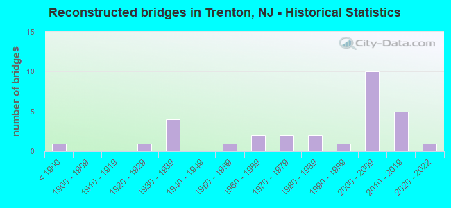
- Reconstructed bridges - Historical Statistics
- 1Before 1900
- 01900-1909
- 01910-1919
- 11920-1929
- 41930-1939
- 01940-1949
- 11950-1959
- 21960-1969
- 21970-1979
- 21980-1989
- 11990-1999
- 102000-2009
- 52010-2019
- 12020-2022
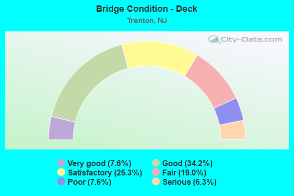
- Bridge Condition - Deck
- 7.6%Very good
- 34.2%Good
- 25.3%Satisfactory
- 19.0%Fair
- 7.6%Poor
- 6.3%Serious
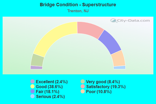
- Bridge Condition - Superstructure
- 2.4%Excellent
- 8.4%Very good
- 38.6%Good
- 19.3%Satisfactory
- 18.1%Fair
- 10.8%Poor
- 2.4%Serious
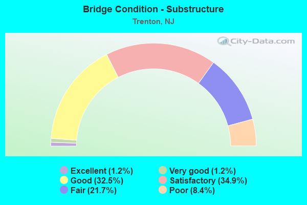
- Bridge Condition - Substructure
- 1.2%Excellent
- 1.2%Very good
- 32.5%Good
- 34.9%Satisfactory
- 21.7%Fair
- 8.4%Poor
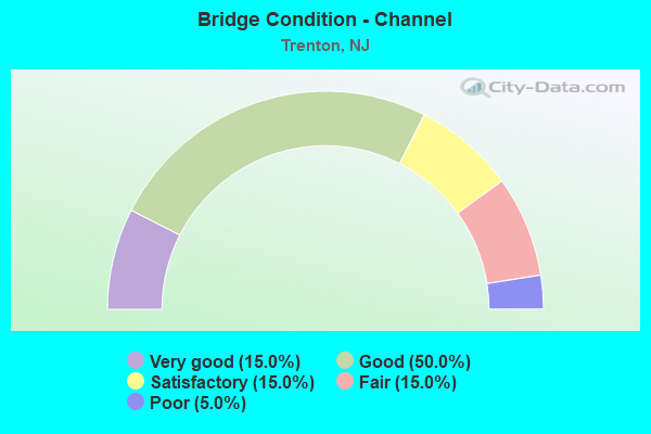
- Bridge Condition - Channel
- 15.0%Very good
- 50.0%Good
- 15.0%Satisfactory
- 15.0%Fair
- 5.0%Poor
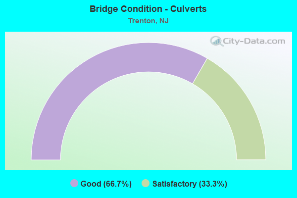
- Bridge Condition - Culverts
- 66.7%Good
- 33.3%Satisfactory
Find on map >> Show street view
Structure Number: 3300022, Location: ADJACENT TO DELAWARE RIV. (Lat: 40.210300, Lng: -74.765111), Route carried "on" structure: US 1, Year Built: 1952, Year Reconstructed: 2009, Status: Open, Structure Length: 2.47m (8.10ft), Average Daily Traffic: 47,400 (year 2020), Truck Traffic: 5%, Average Future Daily Traffic: 53,900 (year 2040), Design Load: HS 20, Features Intersected: RAMP N
Minimum Vertical Clearance: 30+ m (98+ ft), Kilometerpoint: 0.322, Lanes on structure: 4, Lanes under structure: 1, Base Highway Network: Yes, Owner: State Toll Authority, Maintenance Responsibility: Private, Approaching Roadway Width: 20.7m (67.9ft), Skew: 32 degrees, Material/Design: Steel, Design/Construction: Stringer/Multi-beam, Number Of Spans In Main Unit: 1, Length of Maximum Span: 23.5m (77.1ft), Curb-To-Curb Width: 20.8m (68.2ft), Out-to-Out Width: 22.6m (74.1ft)
Condition: Deck: Good, Superstructure: Good, Substructure: Good, Inventory Rating: 57.2 metric tons, Method Used To Determine Inventory Rating: Load Factor (LF), Structural Evaluation: Better than present minimum criteria, Deck Geometry: Equal to present minimum criteria, Underclear: Equal to present minimum criteria, Approach Roadway Alignment: Equal to present desirable criteria, Designated Inspection Frequency: Every 24 months, Inspection Date: June 2021, Deck Structure Type: Concrete Cast-file-Place, Wearing Surface/Protective System: Wearing Surface: Monolithic Concrete, Deck Protection: Epoxy Coated Reinforcing
Find on map >> Show street view
Structure Number: 3300023, Location: ADJACENT TO DELAWARE RIV. (Lat: 40.210000, Lng: -74.765000), Route carried "on" structure: Ramp US 1, Year Built: 1969, Year Reconstructed: 2009, Status: Open, Structure Length: 4.18m (13.71ft), Average Daily Traffic: 2,500 (year 2021), Truck Traffic: 5%, Average Future Daily Traffic: 3,000 (year 2041), Design Load: HS 20, Features Intersected: BRIDGE STREET, Facility Carried by Structure: RAMP IY
Minimum Vertical Clearance: 30+ m (98+ ft), Kilometerpoint: 0.322, Lanes on structure: 2, Lanes under structure: 3, Owner: State Toll Authority, Maintenance Responsibility: Private, Approaching Roadway Width: 6.7m (22.0ft), Skew: 5 degrees, Material/Design: Steel, Design/Construction: Stringer/Multi-beam, Number Of Spans In Main Unit: 3, Length of Maximum Span: 24.1m (79.1ft), Curb-To-Curb Width: 9.5m (31.2ft), Out-to-Out Width: 10.5m (34.4ft)
Condition: Deck: Good, Superstructure: Good, Substructure: Satisfactory, Operating Rating: 85.3 metric tons, Method Used To Determine Operating Rating: Load Factor (LF), Inventory Rating: 50.8 metric tons, Method Used To Determine Inventory Rating: Load Factor (LF), Structural Evaluation: Equal to present minimum criteria, Deck Geometry: Somewhat better than minimum adequacy, Underclear: Somewhat better than minimum adequacy, Approach Roadway Alignment: Better than present minimum criteria, Designated Inspection Frequency: Every 24 months, Inspection Date: June 2021, Deck Structure Type: Concrete Cast-file-Place, Wearing Surface/Protective System: Wearing Surface: Monolithic Concrete, Deck Protection: Epoxy Coated Reinforcing
Find on map >> Show street view
Structure Number: 3300024, Location: ADJACENT TO DELAWARE RIV. (Lat: 40.211669, Lng: -74.765000), Route carried "on" structure: Ramp US 1, Year Built: 1969, Status: Open, Structure Length: 8.72m (28.61ft), Average Daily Traffic: 1,400 (year 2021), Truck Traffic: 5%, Average Future Daily Traffic: 1,700 (year 2041), Design Load: HS 20, Features Intersected: NJ 29 NB & SB, Facility Carried by Structure: RAMP Y
Minimum Vertical Clearance: 30+ m (98+ ft), Kilometerpoint: 0.161, Lanes on structure: 1, Lanes under structure: 8, Owner: State Toll Authority, Maintenance Responsibility: Private, Approaching Roadway Width: 6.7m (22.0ft), Material/Design: Steel continuous, Design/Construction: Stringer/Multi-beam, Number Of Spans In Main Unit: 4, Length of Maximum Span: 28.3m (92.8ft), Curb-To-Curb Width: 7.5m (24.6ft), Out-to-Out Width: 8.5m (27.9ft)
Condition: Deck: Satisfactory, Superstructure: Good, Substructure: Satisfactory, Operating Rating: 52.6 metric tons, Method Used To Determine Operating Rating: Load Factor (LF), Inventory Rating: 30.8 metric tons, Method Used To Determine Inventory Rating: Load Factor (LF), Structural Evaluation: Equal to present minimum criteria, Deck Geometry: Better than present minimum criteria, Underclear: High priority of corrective action, Approach Roadway Alignment: Equal to present desirable criteria, Designated Inspection Frequency: Every 24 months, Inspection Date: June 2021, Deck Structure Type: Concrete Cast-file-Place, Wearing Surface/Protective System: Wearing Surface: Monolithic Concrete
Find on map >> Show street view
Structure Number: 3300025, Location: 1/4 MI. E.OF DELAWARE RIV (Lat: 40.211111, Lng: -74.763611), Route carried "on" structure: US 1, Year Built: 1952, Year Reconstructed: 2009, Status: Open, Structure Length: 2.41m (7.91ft), Average Daily Traffic: 47,400 (year 2020), Truck Traffic: 5%, Average Future Daily Traffic: 53,900 (year 2040), Design Load: HS 20, Features Intersected: UNION STREET
Minimum Vertical Clearance: 30+ m (98+ ft), Kilometerpoint: 0.451, Lanes on structure: 5, Lanes under structure: 4, Base Highway Network: Yes, Owner: State Toll Authority, Maintenance Responsibility: Private, Approaching Roadway Width: 23.2m (76.1ft), Skew: 30 degrees, Material/Design: Steel, Design/Construction: Stringer/Multi-beam, Number Of Spans In Main Unit: 1, Length of Maximum Span: 22.9m (75.1ft), Curb-To-Curb Width: 23.2m (76.1ft), Out-to-Out Width: 24.6m (80.7ft)
Condition: Deck: Good, Superstructure: Satisfactory, Substructure: Good, Inventory Rating: 54.4 metric tons, Method Used To Determine Inventory Rating: Load Factor (LF), Structural Evaluation: Equal to present minimum criteria, Deck Geometry: Somewhat better than minimum adequacy, Underclear: Meets minimum limits, Approach Roadway Alignment: Equal to present desirable criteria, Designated Inspection Frequency: Every 24 months, Inspection Date: June 2021, Deck Structure Type: Concrete Cast-file-Place, Wearing Surface/Protective System: Wearing Surface: Monolithic Concrete, Deck Protection: Epoxy Coated Reinforcing
Find on map >> Show street view
Structure Number: 3300026, Location: 2300FT E.OF DEL RIVER (Lat: 40.213461, Lng: -74.760369), Route carried "on" structure: City street , Year Built: 1952, Year Reconstructed: 2009, Status: Open, Structure Length: 2.93m (9.61ft), Average Daily Traffic: 5,000 (year 2021), Truck Traffic: 5%, Average Future Daily Traffic: 6,000 (year 2041), Design Load: HS 20, Features Intersected: US ROUTE 1, Facility Carried by Structure: CENTRE STREET
Minimum Vertical Clearance: 30+ m (98+ ft), Kilometerpoint: 0.064, Lanes on structure: 2, Lanes under structure: 4, Owner: State Toll Authority, Maintenance Responsibility: Private, Approaching Roadway Width: 12.2m (40.0ft), Skew: 3 degrees, Material/Design: Steel, Design/Construction: Stringer/Multi-beam, Number Of Spans In Main Unit: 1, Length of Maximum Span: 27.7m (90.9ft), Curb or Sidewalk Widths: Left: 4.0m (13.1ft), Right: 4.0m (13.1ft), Curb-To-Curb Width: 12.2m (40.0ft), Out-to-Out Width: 20.7m (67.9ft)
Condition: Deck: Good, Superstructure: Good, Substructure: Satisfactory, Operating Rating: 60.8 metric tons, Method Used To Determine Operating Rating: Load Factor (LF), Inventory Rating: 36.3 metric tons, Method Used To Determine Inventory Rating: Load Factor (LF), Structural Evaluation: Equal to present minimum criteria, Deck Geometry: Equal to present minimum criteria, Underclear: High priority of corrective action, Approach Roadway Alignment: Equal to present desirable criteria, Designated Inspection Frequency: Every 24 months, Inspection Date: June 2021, Deck Structure Type: Concrete Cast-file-Place, Wearing Surface/Protective System: Wearing Surface: Monolithic Concrete
Find on map >> Show street view
Structure Number: 3300027, Location: 0.6 MI.E. DELAWARE RIVER (Lat: 40.213789, Lng: -74.759911), Route carried "on" structure: US 206, Year Built: 1952, Year Reconstructed: 2009, Status: Open, Structure Length: 2.50m (8.20ft), Average Daily Traffic: 6,995 (year 2021), Truck Traffic: 4%, Average Future Daily Traffic: 8,400 (year 2041), Design Load: HS 20, Features Intersected: US RT 1
Minimum Vertical Clearance: 30+ m (98+ ft), Kilometerpoint: 68.091, Lanes on structure: 4, Lanes under structure: 4, Base Highway Network: Yes, Owner: State Toll Authority, Maintenance Responsibility: Private, Approaching Roadway Width: 13.1m (43.0ft), Material/Design: Steel, Design/Construction: Stringer/Multi-beam, Number Of Spans In Main Unit: 1, Length of Maximum Span: 23.5m (77.1ft), Curb or Sidewalk Widths: Left: 4.0m (13.1ft), Right: 4.0m (13.1ft), Curb-To-Curb Width: 13.2m (43.3ft), Out-to-Out Width: 21.8m (71.5ft)
Condition: Deck: Satisfactory, Superstructure: Good, Substructure: Satisfactory, Inventory Rating: 55.3 metric tons, Method Used To Determine Inventory Rating: Load Factor (LF), Structural Evaluation: Equal to present minimum criteria, Deck Geometry: High priority of replacement, Underclear: High priority of corrective action, Approach Roadway Alignment: Equal to present desirable criteria, Designated Inspection Frequency: Every 24 months, Inspection Date: June 2021, Deck Structure Type: Concrete Cast-file-Place, Wearing Surface/Protective System: Wearing Surface: Monolithic Concrete
Find on map >> Show street view
Structure Number: 330003, Location: 0.25 MI E OF RT1&DEL RIV (Lat: 40.210831, Lng: -74.763331), Route carried "on" structure: Ramp US 1, Year Built: 1982, Status: Open, Structure Length: 5.24m (17.19ft), Average Daily Traffic: 3,400 (year 2021), Truck Traffic: 5%, Average Future Daily Traffic: 4,000 (year 2041), Design Load: HS 20, Features Intersected: UNION STREET, Facility Carried by Structure: RAMP N
Minimum Vertical Clearance: 30+ m (98+ ft), Kilometerpoint: 0.451, Lanes on structure: 1, Lanes under structure: 4, Owner: State Toll Authority, Maintenance Responsibility: Private, Approaching Roadway Width: 6.7m (22.0ft), Material/Design: Prestressed concrete, Design/Construction: Stringer/Multi-beam, Number Of Spans In Main Unit: 3, Length of Maximum Span: 23.8m (78.1ft), Curb-To-Curb Width: 6.7m (22.0ft), Out-to-Out Width: 7.8m (25.6ft)
Condition: Deck: Good, Superstructure: Satisfactory, Substructure: Good, Operating Rating: 49.0 metric tons, Method Used To Determine Operating Rating: Load Factor (LF), Inventory Rating: 30.8 metric tons, Method Used To Determine Inventory Rating: Load Factor (LF), Structural Evaluation: Equal to present minimum criteria, Deck Geometry: Equal to present minimum criteria, Underclear: Meets minimum limits, Approach Roadway Alignment: Equal to present desirable criteria, Designated Inspection Frequency: Every 24 months, Inspection Date: June 2021, Deck Structure Type: Concrete Cast-file-Place, Wearing Surface/Protective System: Wearing Surface: Monolithic Concrete, Deck Protection: Epoxy Coated Reinforcing
Find on map >> Show street view
Structure Number: 3300031, Location: 300' NE of DEL. R. (Lat: 40.209831, Lng: -74.766100), Route carried "on" structure: Ramp US 1, Year Built: 2009, Status: Open, Structure Length: 5.58m (18.31ft), Average Daily Traffic: 1,650 (year 2021), Truck Traffic: 5%, Average Future Daily Traffic: 2,000 (year 2041), Design Load: HS 20, Features Intersected: NJ RT 29 NB
Minimum Vertical Clearance: 30+ m (98+ ft), Kilometerpoint: 0.193, Lanes on structure: 1, Lanes under structure: 3, Base Highway Network: Yes, Owner: State Toll Authority, Maintenance Responsibility: Private, Approaching Roadway Width: 9.1m (29.9ft), Material/Design: Steel, Design/Construction: Stringer/Multi-beam, Number Of Spans In Main Unit: 2, Length of Maximum Span: 29.0m (95.1ft), Curb-To-Curb Width: 8.7m (28.5ft), Out-to-Out Width: 9.7m (31.8ft)
Condition: Deck: Good, Superstructure: Very good, Substructure: Very good, Inventory Rating: 54.4 metric tons, Method Used To Determine Inventory Rating: Load Factor (LF), Structural Evaluation: Equal to present desirable criteria, Deck Geometry: Superior to present desirable criteria, Underclear: Somewhat better than minimum adequacy, Approach Roadway Alignment: Equal to present desirable criteria, Designated Inspection Frequency: Every 24 months, Inspection Date: June 2021, Deck Structure Type: Concrete Cast-file-Place, Wearing Surface/Protective System: Wearing Surface: Monolithic Concrete, Deck Protection: Epoxy Coated Reinforcing
Find on map >> Show street view
Structure Number: 330004, Location: NJ 29 SB (Lat: 40.210431, Lng: -74.768550), Route carried "on" structure: City street , Year Built: 1928, Year Reconstructed: 1997, Status: Posted for load, Structure Length: 31.12m (102.10ft), Average Daily Traffic: 15,300 (year 2017), Average Future Daily Traffic: 18,000 (year 2037), Design Load: HS 20, Features Intersected: DELAWARE RIV & NJ 29 SB, Facility Carried by Structure: Bridge Street
Minimum Vertical Clearance: 6.04m (19.82ft), Kilometerpoint: 0.000, Lanes on structure: 2, Lanes under structure: 3, Owner: Local Toll Authority, Approaching Roadway Width: 14.6m (47.9ft), Skew: 30 degrees, Material/Design: Steel, Design/Construction: Truss - Thru, Number Of Spans In Main Unit: 5, Length of Maximum Span: 64.0m (210.0ft), Curb or Sidewalk Widths: Left: 2.4m (7.9ft), Right: 0.0m, Curb-To-Curb Width: 12.2m (40.0ft), Out-to-Out Width: 13.4m (44.0ft)
Condition: Deck: Good, Superstructure: Satisfactory, Substructure: Satisfactory, Channel: Good, Operating Rating: 51.2 metric tons, Method Used To Determine Operating Rating: Allowable Stress (AS), Inventory Rating: 34.7 metric tons, Method Used To Determine Inventory Rating: Allowable Stress (AS), Structural Evaluation: Equal to present minimum criteria, Deck Geometry: Somewhat better than minimum adequacy, Underclear: Equal to present minimum criteria, Waterway Adequacy: Equal to present desirable criteria, Approach Roadway Alignment: Equal to present minimum criteria, Length Of Structure Improvement: 31.70m (104.00ft), Designated Inspection Frequency: Every 24 months, Critical Feature Inspection Frequency: Every 24 months, Underwater Inspection Frequency: Every 60 months, Other Special Inspection Frequency: Every 12 months, Inspection Date: April 2020, Critical Feature Inspection Date: April 2020, Underwater Inspection Date: November 2016, Other Special Inspection Date: April 2021, Roadway Improvement Cost: $1,000, Total Project Cost: $3,000, Deck Structure Type: Open Grating
Find on map >> Show street view
Structure Number: 330006, Location: NJ 29 @ MP 4.34 (Lat: 40.219711, Lng: -74.778339), Route carried "on" structure: City street , Year Built: 1884, Year Reconstructed: 2010, Status: Posted for load, Structure Length: 38.92m (127.69ft), Average Daily Traffic: 16,500 (year 2020), Average Future Daily Traffic: 20,000 (year 2040), Features Intersected: DELAWARE RIVER, Facility Carried by Structure: NJ 29 to PA 32
Minimum Vertical Clearance: 4.21m (13.81ft), Kilometerpoint: 0.000, Lanes on structure: 2, Owner: Local Toll Authority, Approaching Roadway Width: 5.5m (18.0ft), Material/Design: Aluminum, Iron, Design/Construction: Truss - Thru, Number Of Spans In Main Unit: 7, Length of Maximum Span: 54.9m (180.1ft), Curb or Sidewalk Widths: Left: 1.8m (5.9ft), Right: 0.0m, Curb-To-Curb Width: 5.6m (18.4ft), Out-to-Out Width: 6.3m (20.7ft)
Condition: Deck: Good, Superstructure: Good, Substructure: Satisfactory, Channel: Good, Operating Rating: 32.9 metric tons, Method Used To Determine Operating Rating: Allowable Stress (AS), Inventory Rating: 21.0 metric tons, Method Used To Determine Inventory Rating: Allowable Stress (AS), Structural Evaluation: Somewhat better than minimum adequacy, Deck Geometry: High priority of replacement, Waterway Adequacy: Equal to present desirable criteria, Approach Roadway Alignment: Meets minimum limits, Bridge Posting: Required (Relationship of Operating Rating to Maximum Legal Load: 20.0 - 29.9% below), Length Of Structure Improvement: 48.59m (159.42ft), Designated Inspection Frequency: Every 24 months, Critical Feature Inspection Frequency: Every 24 months, Underwater Inspection Frequency: Every 60 months, Other Special Inspection Frequency: Every 12 months, Inspection Date: April 2020, Critical Feature Inspection Date: April 2020, Underwater Inspection Date: November 2016, Other Special Inspection Date: April 2021, Bridge Improvement Cost: $1,000, Roadway Improvement Cost: $2,000, Total Project Cost: $11,000, Deck Structure Type: Open Grating
Find on map >> Show street view
Structure Number: 3300081, Location: .1 ML S OF JCT 29 (Lat: 40.258639, Lng: -74.847500), Route carried "on" structure: Interstate 295, Year Built: 2019, Status: Open, Structure Length: 55.90m (183.40ft), Average Daily Traffic: 58,700 (year 2021), Truck Traffic: 11%, Average Future Daily Traffic: 70,000 (year 2041), Design Load: HL 93, Features Intersected: Del Rvr, NJ29, PA32
Minimum Vertical Clearance: 30+ m (98+ ft), Kilometerpoint: 0.016, Lanes on structure: 4, Lanes under structure: 6, Base Highway Network: Yes, Toll: Toll bridge, Owner: Local Toll Authority, Approaching Roadway Width: 22.3m (73.2ft), Material/Design: Steel continuous, Design/Construction: Stringer/Multi-beam, Number Of Spans In Main Unit: 7, Length of Maximum Span: 85.0m (278.9ft), Curb or Sidewalk Widths: Left: 0.2m (0.7ft), Right: 3.0m (9.8ft), Curb-To-Curb Width: 22.3m (73.2ft), Out-to-Out Width: 26.9m (88.3ft)
Condition: Deck: Good, Superstructure: Excellent, Substructure: Excellent, Channel: Good, Operating Rating: 94.0 metric tons, Method Used To Determine Operating Rating: Assigned ratings based on Load and Resistance Factor Design (LRFD) reported by rating factor (RF) using HL93 loadings, Inventory Rating: 74.5 metric tons, Method Used To Determine Inventory Rating: Assigned ratings based on Load and Resistance Factor Design (LRFD) reported by rating factor (RF) using HL93 loadings, Structural Evaluation: Superior to present desirable criteria, Deck Geometry: Superior to present desirable criteria, Underclear: Superior to present desirable criteria, Waterway Adequacy: Superior to present desirable criteria, Approach Roadway Alignment: Equal to present desirable criteria, Length Of Structure Improvement: 55.90m (183.40ft), Designated Inspection Frequency: Every 24 months, Inspection Date: August 2021, Deck Structure Type: Concrete Cast-file-Place, Wearing Surface/Protective System: Wearing Surface: Other, Deck Protection: Galvanized Reinforcing
Find on map >> Show street view
Structure Number: 1100049, Location: 0.23 MI N OF PERRY ST. (Lat: 40.227669, Lng: -74.756169), Route carried "under" structure: US 1, Year Built: 2006, Structure Length: 0. m, Average Daily Traffic: 66,434 (year 2021), Truck Traffic: 5%, Features Intersected: US 1 and CONRAIL, Facility Carried by Structure: SOUTHARD STREET
Minimum Vertical Clearance: 5.00m (16.40ft), Kilometerpoint: 2.655, Lanes on structure: 2, Lanes under structure: 4, Material/Design: Steel continuous, Design/Construction: Stringer/Multi-beam, Length of Maximum Span: 43.9m (144.0ft)
Find on map >> Show street view
Structure Number: 110005, Location: 0.97 MI N of RT. 33 Int. (Lat: 40.234719, Lng: -74.746331), Route carried "under" structure: US 1, Year Built: 1994, Structure Length: 0. m, Average Daily Traffic: 52,434 (year 2021), Truck Traffic: 5%, Features Intersected: Rt. US 1 and CONRAIL, Facility Carried by Structure: N Olden Ave CR 622
Minimum Vertical Clearance: 4.82m (15.81ft), Kilometerpoint: 3.814, Lanes on structure: 2, Lanes under structure: 4, Material/Design: Steel continuous, Design/Construction: Stringer/Multi-beam, Length of Maximum Span: 38.1m (125.0ft)
Find on map >> Show street view
Structure Number: 1101153, Location: 0.9 MILES NO. OF DEL.RIV. (Lat: 40.218000, Lng: -74.757400), Route carried "under" structure: State highway 33, Year Built: 1949, Structure Length: 0. m, Average Daily Traffic: 13,798 (year 2020), Truck Traffic: 4%, Features Intersected: NJ 33 (MARKET ST), Facility Carried by Structure: US 1
Minimum Vertical Clearance: 5.11m (16.77ft), Kilometerpoint: 0.000, Lanes on structure: 4, Lanes under structure: 4, Material/Design: Steel, Design/Construction: Stringer/Multi-beam, Length of Maximum Span: 14.3m (46.9ft)
Find on map >> Show street view
Structure Number: 1101155, Location: 1.1 MILES N. OF DEL.RIV. (Lat: 40.220669, Lng: -74.758231), Route carried "under" structure: US 1, Year Built: 1953, Structure Length: 0. m, Average Daily Traffic: 71,875 (year 2021), Truck Traffic: 5%, Features Intersected: US 1, Facility Carried by Structure: EAST STATE STREET
Minimum Vertical Clearance: 4.55m (14.93ft), Kilometerpoint: 1.770, Lanes on structure: 2, Lanes under structure: 5, Material/Design: Steel, Design/Construction: Stringer/Multi-beam, Length of Maximum Span: 25.3m (83.0ft)
Find on map >> Show street view
Structure Number: 1101156, Location: 1.4 MILES NO OF DEL.RIV. (Lat: 40.224089, Lng: -74.759200), Route carried "under" structure: US 1, Year Built: 1951, Structure Length: 0. m, Average Daily Traffic: 64,647 (year 2021), Truck Traffic: 5%, Features Intersected: US 1, Facility Carried by Structure: PERRY STREET
Minimum Vertical Clearance: 4.60m (15.09ft), Kilometerpoint: 2.157, Lanes on structure: 2, Lanes under structure: 6, Material/Design: Steel, Design/Construction: Stringer/Multi-beam, Length of Maximum Span: 25.9m (85.0ft)
Find on map >> Show street view
Structure Number: 1101159, Location: 4.5 MILES SOUTH OF 1-295 (Lat: 40.234581, Lng: -74.748331), Route carried "under" structure: Ramp US 1, Year Built: 1953, Structure Length: 0. m, Average Daily Traffic: 4,505 (year 2020), Truck Traffic: 5%, Features Intersected: RAMP TO OLDEN AV (CR622)
Minimum Vertical Clearance: 4.60m (15.09ft), Kilometerpoint: 3.637, Lanes on structure: 2, Lanes under structure: 1, Material/Design: Steel, Design/Construction: Stringer/Multi-beam, Length of Maximum Span: 26.5m (86.9ft)
Find on map >> Show street view
Structure Number: 1101161, Location: 4.0 MILES SOUTH OF I-295 (Lat: 40.238419, Lng: -74.741719), Route carried "under" structure: City street , Year Built: 1953, Structure Length: 0. m, Average Daily Traffic: 8,356 (year 2020), Truck Traffic: 3%, Features Intersected: MULBERRY STREET, Facility Carried by Structure: US 1
Minimum Vertical Clearance: 4.70m (15.42ft), Kilometerpoint: 0.499, Lanes on structure: 4, Lanes under structure: 2, Material/Design: Steel, Design/Construction: Stringer/Multi-beam, Length of Maximum Span: 19.2m (63.0ft)
Find on map >> Show street view
Structure Number: 1101162, Location: 3.0 miles north of NJ 29 (Lat: 40.240550, Lng: -74.739069), Route carried "under" structure: US 1, Year Built: 1953, Structure Length: 0. m, Average Daily Traffic: 25,966 (year 2020), Truck Traffic: 5%, Features Intersected: D&R CANAL AND US 1 SB
Minimum Vertical Clearance: 5.23m (17.16ft), Kilometerpoint: 4.715, Lanes on structure: 4, Lanes under structure: 1, Material/Design: Steel, Design/Construction: Stringer/Multi-beam, Length of Maximum Span: 29.9m (98.1ft)
Find on map >> Show street view
Structure Number: 1101163, Location: 0.5 MILES SO OF RT 206 (Lat: 40.241861, Lng: -74.739269), Route carried "under" structure: City street , Year Built: 1953, Structure Length: 0. m, Average Daily Traffic: 688 (year 2021), Truck Traffic: 1%, Features Intersected: NEW YORK AVENUE, Facility Carried by Structure: ROUTE US 1B
Minimum Vertical Clearance: 6.45m (21.16ft), Kilometerpoint: 0.000, Lanes on structure: 4, Lanes under structure: 2, Material/Design: Steel, Design/Construction: Stringer/Multi-beam, Length of Maximum Span: 21.3m (69.9ft)
Find on map >> Show street view
Structure Number: 1101164, Location: 0.3 MI. N. OF S. BROAD ST (Lat: 40.217769, Lng: -74.757981), Route carried "under" structure: State highway 33, Year Built: 1994, Structure Length: 0. m, Average Daily Traffic: 15,273 (year 2021), Truck Traffic: 4%, Features Intersected: MARKET STREET(NJ 33), Facility Carried by Structure: U.S. 1 RAMP C
Minimum Vertical Clearance: 5.87m (19.26ft), Kilometerpoint: 1.062, Lanes on structure: 1, Lanes under structure: 6, Material/Design: Steel continuous, Design/Construction: Stringer/Multi-beam, Length of Maximum Span: 16.5m (54.1ft)
Find on map >> Show street view
Structure Number: 110615, Location: 1.0 MI NW OF 129 JCT (Lat: 40.221331, Lng: -74.775550), Route carried "under" structure: State highway 29, Year Built: 1955, Structure Length: 0. m, Average Daily Traffic: 51,220 (year 2020), Truck Traffic: 5%, Features Intersected: NJ 29, Facility Carried by Structure: CALHOUN STREET
Minimum Vertical Clearance: 4.93m (16.17ft), Kilometerpoint: 6.985, Lanes on structure: 4, Lanes under structure: 6, Material/Design: Concrete, Design/Construction: Frame, Length of Maximum Span: 26.8m (87.9ft)
Find on map >> Show street view
Structure Number: 1106155, Location: 0.61 MI N OF JCT RT 1 (Lat: 40.218019, Lng: -74.770289), Route carried "under" structure: Ramp State highway 29, Year Built: 1969, Structure Length: 0. m, Average Daily Traffic: 3,647 (year 2020), Truck Traffic: 5%, Features Intersected: NJ 29 RAMP CI
Minimum Vertical Clearance: 4.47m (14.67ft), Kilometerpoint: 6.405, Lanes on structure: 3, Lanes under structure: 1, Material/Design: Steel, Design/Construction: Stringer/Multi-beam, Length of Maximum Span: 25.9m (85.0ft)
Find on map >> Show street view
Structure Number: 110715, Location: 0.73 MI S OF CR 579 JCT (Lat: 40.230619, Lng: -74.792700), Route carried "under" structure: County highway 636, Year Built: 1956, Structure Length: 0. m, Average Daily Traffic: 7,166 (year 2022), Truck Traffic: 4%, Features Intersected: PARKSIDE AVE (CR 636), Facility Carried by Structure: NJ 29 NB
Minimum Vertical Clearance: 4.80m (15.75ft), Kilometerpoint: 0.000, Lanes on structure: 2, Lanes under structure: 1, Material/Design: Steel, Design/Construction: Stringer/Multi-beam, Length of Maximum Span: 19.2m (63.0ft)
Find on map >> Show street view
Structure Number: 112615, Location: 3.8 MI NORTH OF DEL. RIV. (Lat: 40.248369, Lng: -74.727919), Route carried "under" structure: County highway 616, Year Built: 1973, Structure Length: 0. m, Average Daily Traffic: 15,595 (year 2020), Truck Traffic: 4%, Features Intersected: WHITEHEAD RD.(CO RT 616), Facility Carried by Structure: US 1
Minimum Vertical Clearance: 5.49m (18.01ft), Kilometerpoint: 1.513, Lanes on structure: 5, Lanes under structure: 4, Material/Design: Steel, Design/Construction: Stringer/Multi-beam, Length of Maximum Span: 30.2m (99.1ft)
Find on map >> Show street view
Structure Number: 1130154, Location: 1.74 MI NORTH OF I-295 (Lat: 40.192269, Lng: -74.750919), Route carried "under" structure: State highway 129, Year Built: 1995, Structure Length: 0. m, Average Daily Traffic: 25,470 (year 2020), Truck Traffic: 4%, Features Intersected: NJ 129 & NJT RIVER LINE, Facility Carried by Structure: NJ 29
Minimum Vertical Clearance: 7.47m (24.51ft), Kilometerpoint: 1.030, Lanes on structure: 6, Lanes under structure: 4, Material/Design: Steel continuous, Design/Construction: Stringer/Multi-beam, Length of Maximum Span: 46.0m (150.9ft)
Find on map >> Show street view
Structure Number: 1130155, Location: 1.6 MI NORTH OF I-295 (Lat: 40.189811, Lng: -74.750819), Route carried "under" structure: State highway 129, Year Built: 1995, Structure Length: 0. m, Average Daily Traffic: 1,238 (year 2020), Truck Traffic: 4%, Features Intersected: NJ 129 NB & NJ TRANSIT
Minimum Vertical Clearance: 6.78m (22.24ft), Kilometerpoint: 0.740, Lanes on structure: 2, Lanes under structure: 1, Material/Design: Steel continuous, Design/Construction: Stringer/Multi-beam, Length of Maximum Span: 45.7m (149.9ft)
Find on map >> Show street view
Structure Number: 1130156, Location: 1.64MI N OF I-295&NJ29JCT (Lat: 40.192839, Lng: -74.750900), Route carried "under" structure: State highway 129, Year Built: 1995, Structure Length: 0. m, Average Daily Traffic: 1,238 (year 2020), Truck Traffic: 4%, Features Intersected: NJ 129 NB & NJ TRANSIT
Minimum Vertical Clearance: 5.84m (19.16ft), Kilometerpoint: 1.175, Lanes on structure: 2, Lanes under structure: 1, Material/Design: Steel continuous, Design/Construction: Stringer/Multi-beam, Length of Maximum Span: 44.2m (145.0ft)
Find on map >> Show street view
Structure Number: 113115, Location: 0.05 mi north of US 1 (Lat: 40.210550, Lng: -74.766669), Route carried "under" structure: State highway 29, Year Built: 1970, Structure Length: 0. m, Average Daily Traffic: 26,013 (year 2020), Truck Traffic: 1%, Features Intersected: NJ 29 NB, Facility Carried by Structure: BRIDGE STREET
Minimum Vertical Clearance: 4.72m (15.49ft), Kilometerpoint: 5.504, Lanes on structure: 2, Lanes under structure: 4, Material/Design: Steel, Design/Construction: Stringer/Multi-beam, Length of Maximum Span: 21.9m (71.9ft)
Find on map >> Show street view
Structure Number: 1131151, Location: 0.3 MI NW OF 1-29 JCT (Lat: 40.213539, Lng: -74.767600), Route carried "under" structure: City street , Year Built: 1969, Structure Length: 0. m, Average Daily Traffic: 10,908 (year 2020), Truck Traffic: 4%, Features Intersected: MARKET STREET, Facility Carried by Structure: NJ 29 NORTHBOUND
Minimum Vertical Clearance: 4.57m (14.99ft), Kilometerpoint: 0.000, Lanes on structure: 3, Lanes under structure: 2, Material/Design: Steel, Design/Construction: Stringer/Multi-beam, Length of Maximum Span: 29.0m (95.1ft)
Find on map >> Show street view
Structure Number: 1131152, Location: 0.5 MI N OF US 1 JCT (Lat: 40.216231, Lng: -74.769161), Route carried "under" structure: Ramp State highway 29, Year Built: 1969, Structure Length: 0. m, Average Daily Traffic: 13,343 (year 2020), Truck Traffic: 3%, Features Intersected: RAMP 'D'
Minimum Vertical Clearance: 4.67m (15.32ft), Kilometerpoint: 6.180, Lanes on structure: 7, Lanes under structure: 1, Material/Design: Steel, Design/Construction: Stringer/Multi-beam, Length of Maximum Span: 24.1m (79.1ft)
Find on map >> Show street view
Structure Number: 114015, Location: 0.54 Miles S of US 1 Jct. (Lat: 40.209531, Lng: -74.755311), Route carried "under" structure: State highway 129, Year Built: 1992, Structure Length: 0. m, Average Daily Traffic: 29,134 (year 2020), Truck Traffic: 4%, Features Intersected: NJ ROUTE 129, Facility Carried by Structure: S. Broad St (206)
Minimum Vertical Clearance: 5.70m (18.70ft), Kilometerpoint: 3.009, Lanes on structure: 2, Lanes under structure: 4, Material/Design: Steel continuous, Design/Construction: Stringer/Multi-beam, Length of Maximum Span: 21.9m (71.9ft)
Find on map >> Show street view
Structure Number: 1140152, Location: 2.3MI NW OF I295 & NJ JCT (Lat: 40.215439, Lng: -74.757239), Route carried "under" structure: US 1, Year Built: 1994, Structure Length: 0. m, Average Daily Traffic: 70,770 (year 2020), Truck Traffic: 5%, Features Intersected: US1;RMP FRM US1NB&AMTRAK
Minimum Vertical Clearance: 5.64m (18.50ft), Kilometerpoint: 1.223, Lanes on structure: 2, Lanes under structure: 4, Material/Design: Steel continuous, Design/Construction: Stringer/Multi-beam, Length of Maximum Span: 39.0m (128.0ft)
Find on map >> Show street view
Structure Number: 1140152, Location: 2.3MI NW OF I295 & NJ JCT (Lat: 40.215439, Lng: -74.757239), Route carried "under" structure: Ramp US 1, Year Built: 1994, Structure Length: 0. m, Average Daily Traffic: 560 (year 2020), Truck Traffic: 5%, Features Intersected: US1;RMP FRM US1NB&AMTRAK
Minimum Vertical Clearance: 7.11m (23.33ft), Kilometerpoint: 1.223, Lanes on structure: 2, Lanes under structure: 1, Material/Design: Steel continuous, Design/Construction: Stringer/Multi-beam, Length of Maximum Span: 39.0m (128.0ft)
Find on map >> Show street view
Structure Number: 1140153, Location: 0.21 MI N of CR 606 (Lat: 40.216481, Lng: -74.757039), Route carried "under" structure: Ramp US 1, Year Built: 1994, Structure Length: 0. m, Average Daily Traffic: 4,718 (year 2020), Truck Traffic: 4%, Features Intersected: US 1 RAMP "G"
Minimum Vertical Clearance: 5.72m (18.77ft), Kilometerpoint: 1.223, Lanes on structure: 1, Lanes under structure: 1, Material/Design: Steel, Design/Construction: Stringer/Multi-beam, Length of Maximum Span: 21.6m (70.9ft)
Find on map >> Show street view
Structure Number: 1140155, Location: 0.27MI N OF CR606 (Lat: 40.218039, Lng: -74.757881), Route carried "under" structure: City street , Year Built: 1994, Structure Length: 0. m, Average Daily Traffic: 7,941 (year 2020), Truck Traffic: 4%, Features Intersected: MARKET STREET, Facility Carried by Structure: NJ 129 SB
Minimum Vertical Clearance: 5.54m (18.18ft), Kilometerpoint: 1.062, Lanes on structure: 2, Lanes under structure: 4, Material/Design: Steel continuous, Design/Construction: Stringer/Multi-beam, Length of Maximum Span: 18.0m (59.1ft)
Find on map >> Show street view
Structure Number: 330002, Location: Trenton (Lat: 40.208300, Lng: -74.768300), Route carried "under" structure: State highway 29, Year Built: 1952, Structure Length: 0. m, Average Daily Traffic: 25,975 (year 2021), Features Intersected: PA32,NJ29SB,NSRC,DELR, Facility Carried by Structure: US 1
Minimum Vertical Clearance: 5.55m (18.21ft), Kilometerpoint: 5.391, Lanes on structure: 6, Lanes under structure: 3, Material/Design: Steel, Design/Construction: Stringer/Multi-beam, Length of Maximum Span: 34.1m (111.9ft)
Find on map >> Show street view
Structure Number: 330002, Location: Trenton (Lat: 40.208300, Lng: -74.768300), Route carried "under" structure: City street , Year Built: 1952, Structure Length: 0. m, Average Daily Traffic: 510 (year 2021), Features Intersected: PA32,NJ29SB,NSRC,DELR, Facility Carried by Structure: US 1
Minimum Vertical Clearance: 4.97m (16.31ft), Kilometerpoint: 0.000, Lanes on structure: 6, Lanes under structure: 2, Material/Design: Steel, Design/Construction: Stringer/Multi-beam, Length of Maximum Span: 34.1m (111.9ft)
Find on map >> Show street view
Structure Number: 3300021, Location: AT RT 1 & RT 29 NB JCT (Lat: 40.209969, Lng: -74.766111), Route carried "under" structure: State highway 29, Year Built: 1965, Structure Length: 0. m, Average Daily Traffic: 23,481 (year 2021), Truck Traffic: 5%, Features Intersected: NJ 29 NB, Facility Carried by Structure: US RT 1
Minimum Vertical Clearance: 5.43m (17.81ft), Kilometerpoint: 5.423, Lanes on structure: 5, Lanes under structure: 3, Material/Design: Prestressed concrete, Design/Construction: Stringer/Multi-beam, Length of Maximum Span: 18.6m (61.0ft)
Find on map >> Show street view
Structure Number: 3300022, Location: ADJACENT TO DELAWARE RIV. (Lat: 40.210300, Lng: -74.765111), Route carried "under" structure: Ramp State highway 1, Year Built: 1952, Structure Length: 0. m, Average Daily Traffic: 1,200 (year 2021), Truck Traffic: 1%, Features Intersected: RAMP N
Minimum Vertical Clearance: 5.72m (18.77ft), Kilometerpoint: 0.322, Lanes on structure: 4, Lanes under structure: 1, Material/Design: Steel, Design/Construction: Stringer/Multi-beam, Length of Maximum Span: 23.5m (77.1ft)
Find on map >> Show street view
Structure Number: 3300023, Location: ADJACENT TO DELAWARE RIV. (Lat: 40.210000, Lng: -74.765000), Route carried "under" structure: City street , Year Built: 1969, Structure Length: 0. m, Average Daily Traffic: 16,000 (year 2021), Features Intersected: BRIDGE STREET, Facility Carried by Structure: RAMP IY
Minimum Vertical Clearance: 4.51m (14.80ft), Kilometerpoint: 0.740, Lanes on structure: 2, Lanes under structure: 3, Material/Design: Steel, Design/Construction: Stringer/Multi-beam, Length of Maximum Span: 24.1m (79.1ft)
Find on map >> Show street view
Structure Number: 3300024, Location: ADJACENT TO DELAWARE RIV. (Lat: 40.211669, Lng: -74.765000), Route carried "under" structure: State highway 29, Year Built: 1969, Structure Length: 0. m, Average Daily Traffic: 44,172 (year 2021), Truck Traffic: 5%, Features Intersected: NJ 29 NB & SB, Facility Carried by Structure: RAMP Y
Minimum Vertical Clearance: 4.82m (15.81ft), Kilometerpoint: 5.617, Lanes on structure: 1, Lanes under structure: 8, Material/Design: Steel continuous, Design/Construction: Stringer/Multi-beam, Length of Maximum Span: 28.3m (92.8ft)
Find on map >> Show street view
Structure Number: 3300025, Location: 1/4 MI. E.OF DELAWARE RIV (Lat: 40.211111, Lng: -74.763611), Route carried "under" structure: City street , Year Built: 1952, Structure Length: 0. m, Average Daily Traffic: 1,200 (year 2021), Truck Traffic: 3%, Features Intersected: UNION STREET, Facility Carried by Structure: US ROUTE 1
Minimum Vertical Clearance: 5.33m (17.49ft), Kilometerpoint: 0.000, Lanes on structure: 5, Lanes under structure: 4, Material/Design: Steel, Design/Construction: Stringer/Multi-beam, Length of Maximum Span: 22.9m (75.1ft)
Find on map >> Show street view
Structure Number: 3300026, Location: 2300FT E.OF DEL RIVER (Lat: 40.213461, Lng: -74.760369), Route carried "under" structure: US 1, Year Built: 1952, Structure Length: 0. m, Average Daily Traffic: 47,400 (year 2020), Truck Traffic: 3%, Features Intersected: US ROUTE 1, Facility Carried by Structure: CENTRE STREET
Minimum Vertical Clearance: 5.21m (17.09ft), Kilometerpoint: 0.837, Lanes on structure: 2, Lanes under structure: 4, Material/Design: Steel, Design/Construction: Stringer/Multi-beam, Length of Maximum Span: 27.7m (90.9ft)
Find on map >> Show street view
Structure Number: 3300027, Location: 0.6 MI.E. DELAWARE RIVER (Lat: 40.213789, Lng: -74.759911), Route carried "under" structure: US 1, Year Built: 1952, Structure Length: 0. m, Average Daily Traffic: 47,400 (year 2020), Truck Traffic: 5%, Features Intersected: US RT 1, Facility Carried by Structure: BROAD ST (US 206)
Minimum Vertical Clearance: 5.39m (17.68ft), Kilometerpoint: 0.885, Lanes on structure: 4, Lanes under structure: 4, Material/Design: Steel, Design/Construction: Stringer/Multi-beam, Length of Maximum Span: 23.5m (77.1ft)
Find on map >> Show street view
Structure Number: 330003, Location: 0.25 MI E OF RT1&DEL RIV (Lat: 40.210831, Lng: -74.763331), Route carried "under" structure: City street , Year Built: 1982, Structure Length: 0. m, Average Daily Traffic: 1,200 (year 2021), Truck Traffic: 3%, Features Intersected: UNION STREET, Facility Carried by Structure: RAMP N
Minimum Vertical Clearance: 4.54m (14.90ft), Kilometerpoint: 0.048, Lanes on structure: 1, Lanes under structure: 4, Material/Design: Prestressed concrete, Design/Construction: Stringer/Multi-beam, Length of Maximum Span: 23.8m (78.1ft)
Find on map >> Show street view
Structure Number: 3300031, Location: 300' NE of DEL. R. (Lat: 40.209831, Lng: -74.766100), Route carried "under" structure: State highway 29, Year Built: 2009, Structure Length: 0. m, Average Daily Traffic: 23,481 (year 2021), Truck Traffic: 5%, Features Intersected: NJ RT 29 NB, Facility Carried by Structure: US RT 1 RAMP C
Minimum Vertical Clearance: 5.33m (17.49ft), Kilometerpoint: 5.423, Lanes on structure: 1, Lanes under structure: 3, Material/Design: Steel, Design/Construction: Stringer/Multi-beam, Length of Maximum Span: 29.0m (95.1ft)
Find on map >> Show street view
Structure Number: 330004, Location: NJ 29 SB (Lat: 40.210431, Lng: -74.768550), Route carried "under" structure: State highway 29, Year Built: 1928, Structure Length: 0. m, Average Daily Traffic: 22,120 (year 2016), Truck Traffic: 4%, Features Intersected: DELAWARE RIV & NJ 29 SB, Facility Carried by Structure: Bridge Street
Minimum Vertical Clearance: 4.50m (14.76ft), Kilometerpoint: 5.391, Lanes on structure: 2, Lanes under structure: 3, Material/Design: Steel, Design/Construction: Truss - Thru, Length of Maximum Span: 64.0m (210.0ft)
Find on map >> Show street view
Structure Number: 3300081, Location: .1 ML S OF JCT 29 (Lat: 40.258639, Lng: -74.847500), Route carried "under" structure: State highway 29, Year Built: 2019, Structure Length: 0. m, Average Daily Traffic: 5,000 (year 2021), Features Intersected: Del Rvr, NJ29, PA32
Minimum Vertical Clearance: 9.14m (29.99ft), Kilometerpoint: 0.000, Lanes on structure: 4, Lanes under structure: 2, Material/Design: Steel continuous, Design/Construction: Stringer/Multi-beam, Length of Maximum Span: 85.0m (278.9ft)