Bridge Statistics for Tumwater, Washington (WA)
Condition, Traffic, Stress, Structural Evaluation, Project Costs
- National Bridge Inventory (NBI) Statistics
- 45Number of bridges
- 653ft / 199mTotal length
- $148,516,000Total costs
- 1,423,833Total average daily traffic
- 161,367Total average daily truck traffic
- National Bridge Inventory (NBI) Registered Bridges for Tumwater
- No street view available for this location
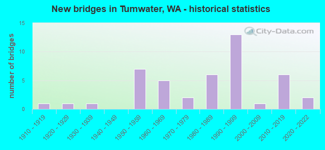
- New bridges - historical statistics
- 11910-1919
- 11920-1929
- 11930-1939
- 71950-1959
- 51960-1969
- 21970-1979
- 61980-1989
- 131990-1999
- 12000-2009
- 62010-2019
- 22020-2022
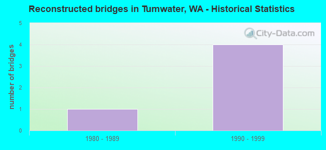
- Reconstructed bridges - Historical Statistics
- 11980-1989
- 41990-1999
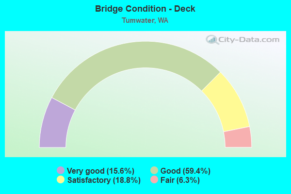
- Bridge Condition - Deck
- 15.6%Very good
- 59.4%Good
- 18.8%Satisfactory
- 6.3%Fair
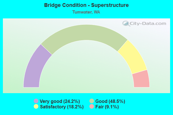
- Bridge Condition - Superstructure
- 24.2%Very good
- 48.5%Good
- 18.2%Satisfactory
- 9.1%Fair
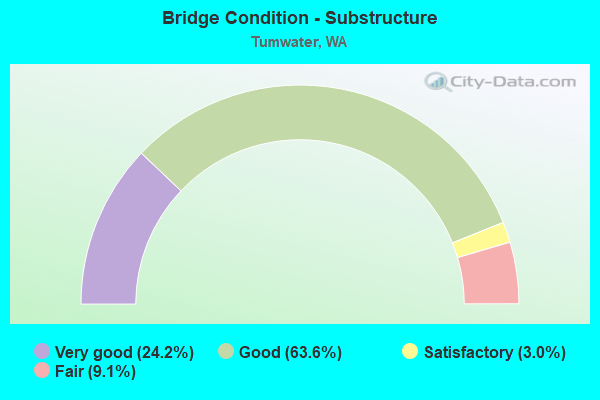
- Bridge Condition - Substructure
- 24.2%Very good
- 63.6%Good
- 3.0%Satisfactory
- 9.1%Fair
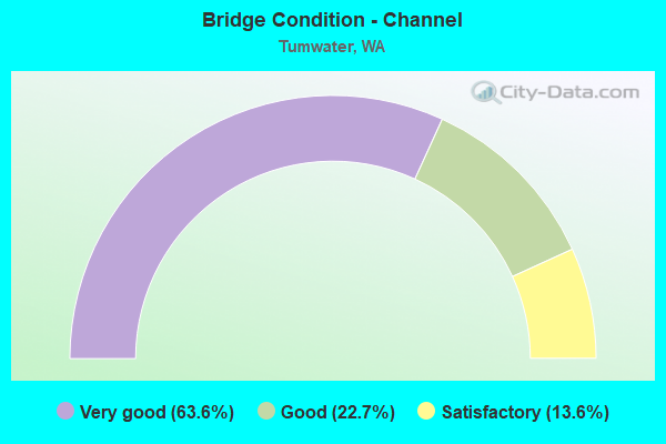
- Bridge Condition - Channel
- 63.6%Very good
- 22.7%Good
- 13.6%Satisfactory
Find on map >> Show street view
Structure Number: 4887A, Location: 4.0 N JCT SR 121 (Lat: 47.006903, Lng: -122.908161), Route carried "on" structure: Interstate 5, Year Built: 1955, Year Reconstructed: 1990, Status: Open, Structure Length: 1.62m (5.31ft), Average Daily Traffic: 109,116 (year 2019), Truck Traffic: 12%, Average Future Daily Traffic: 157,999 (year 2039), Design Load: HS 20, Features Intersected: LINWOOD AVE
Minimum Vertical Clearance: 30+ m (98+ ft), Kilometerpoint: 166.245, Lanes on structure: 6, Lanes under structure: 2, Base Highway Network: Yes, Owner: State Highway Agency, Approaching Roadway Width: 31.7m (104.0ft), Skew: 30 degrees, Material/Design: Concrete, Design/Construction: Slab, Number Of Spans In Main Unit: 1, Length of Maximum Span: 15.5m (50.9ft), Curb-To-Curb Width: 31.7m (104.0ft), Out-to-Out Width: 32.6m (107.0ft)
Condition: Deck: Good, Superstructure: Good, Substructure: Good, Operating Rating: 59.0 metric tons, Method Used To Determine Operating Rating: Load Factor (LF), Inventory Rating: 34.5 metric tons, Method Used To Determine Inventory Rating: Load Factor (LF), Structural Evaluation: Better than present minimum criteria, Deck Geometry: Superior to present desirable criteria, Underclear: Meets minimum limits, Approach Roadway Alignment: Equal to present desirable criteria, Length Of Structure Improvement: 1.62m (5.31ft), Designated Inspection Frequency: Every 48 months, Inspection Date: September 2018, Bridge Improvement Cost: $1,124,000, Roadway Improvement Cost: $225,000, Total Project Cost: $2,247,000 ( Estimate for 2014), Deck Structure Type: Concrete Cast-file-Place, Wearing Surface/Protective System: Wearing Surface: Latex Concrete
Find on map >> Show street view
Structure Number: 4950A, Location: 4.7 N JCT SR 121 (Lat: 47.016472, Lng: -122.906472), Route carried "on" structure: City street , Year Built: 1956, Year Reconstructed: 1990, Status: Posted for load, Structure Length: 16.15m (52.99ft), Average Daily Traffic: 14,308 (year 2002), Truck Traffic: 2%, Average Future Daily Traffic: 25,983 (year 2036), Design Load: HS 15, Features Intersected: I-5, DESCHUTES RIVER, Facility Carried by Structure: CUSTER WAY
Minimum Vertical Clearance: 30+ m (98+ ft), Kilometerpoint: 0.032, Lanes on structure: 3, Lanes under structure: 9, Owner: State Highway Agency, Approaching Roadway Width: 11.9m (39.0ft), Skew: 9 degrees, Material/Design: Concrete, Design/Construction: Arch - Deck, Number Of Spans In Main Unit: 1, Number Of Approach Spans: 4, Length of Maximum Span: 50.3m (165.0ft), Curb or Sidewalk Widths: Left: 0.0m, Right: 3.4m (11.2ft), Curb-To-Curb Width: 11.1m (36.4ft), Out-to-Out Width: 15.1m (49.5ft)
Condition: Deck: Satisfactory, Superstructure: Good, Substructure: Good, Channel: Very good, Operating Rating: 10.7 metric tons, Method Used To Determine Operating Rating: Load and Resistance Factor Rating (LRFR) rating reported by rating factor(RF) method using HL-93 loadings, Inventory Rating: 8.1 metric tons, Method Used To Determine Inventory Rating: Load and Resistance Factor Rating (LRFR) rating reported by rating factor(RF) method using HL-93 loadings, Structural Evaluation: High priority of corrective action, Deck Geometry: High priority of replacement, Underclear: Meets minimum limits, Waterway Adequacy: Equal to present desirable criteria, Approach Roadway Alignment: Equal to present desirable criteria, Bridge Posting: Required (Relationship of Operating Rating to Maximum Legal Load: 30.0 - 39.9% below), Length Of Structure Improvement: 16.15m (52.99ft), Designated Inspection Frequency: Every 24 months, Inspection Date: October 2021, Bridge Improvement Cost: $4,346,000, Roadway Improvement Cost: $869,000, Total Project Cost: $8,692,000 ( Estimate for 2014), Deck Structure Type: Concrete Cast-file-Place, Wearing Surface/Protective System: Wearing Surface: Epoxy Overlay, Deck Protection: Epoxy Coated Reinforcing
Find on map >> Show street view
Structure Number: 5090A, Location: 0.5 N JCT US 101 (Lat: 47.023581, Lng: -122.903650), Route carried "on" structure: Interstate 5, Year Built: 1956, Year Reconstructed: 1986, Status: Open, Structure Length: 11.95m (39.21ft), Average Daily Traffic: 106,266 (year 2019), Truck Traffic: 12%, Average Future Daily Traffic: 153,873 (year 2039), Design Load: HS 20, Features Intersected: CAPITOL LAKE
Minimum Vertical Clearance: 30+ m (98+ ft), Kilometerpoint: 168.209, Lanes on structure: 11, Base Highway Network: Yes, Owner: State Highway Agency, Approaching Roadway Width: 25.9m (85.0ft), Skew: 30 degrees, Material/Design: Concrete continuous, Design/Construction: Box Beam or Girders - Multiple, Number Of Spans In Main Unit: 4, Length of Maximum Span: 33.5m (109.9ft), Curb-To-Curb Width: 52.4m (171.9ft), Out-to-Out Width: 64.0m (210.0ft)
Condition: Deck: Good, Superstructure: Good, Substructure: Good, Channel: Good, Operating Rating: 84.4 metric tons, Method Used To Determine Operating Rating: Load Factor (LF), Inventory Rating: 49.9 metric tons, Method Used To Determine Inventory Rating: Load Factor (LF), Structural Evaluation: Better than present minimum criteria, Deck Geometry: Superior to present desirable criteria, Waterway Adequacy: Equal to present desirable criteria, Approach Roadway Alignment: Equal to present desirable criteria, Length Of Structure Improvement: 11.95m (39.21ft), Designated Inspection Frequency: Every 24 months, Underwater Inspection Frequency: Every 60 months, Inspection Date: November 2021, Underwater Inspection Date: May 2021, Bridge Improvement Cost: $6,821,000, Roadway Improvement Cost: $1,364,000, Total Project Cost: $13,642,000 ( Estimate for 2014), Deck Structure Type: Concrete Cast-file-Place, Wearing Surface/Protective System: Wearing Surface: Bituminous, Membrane: Preformed Fabric
Find on map >> Show street view
Structure Number: 5129A, Location: 5.0 N JCT SR 121 (Lat: 47.020833, Lng: -122.906333), Route carried "on" structure: Interstate 5, Year Built: 1956, Year Reconstructed: 1990, Status: Open, Structure Length: 3.60m (11.81ft), Average Daily Traffic: 106,266 (year 2019), Truck Traffic: 12%, Average Future Daily Traffic: 153,873 (year 2039), Design Load: HS 20, Features Intersected: DESCHUTES PARKWAY
Minimum Vertical Clearance: 5.21m (17.09ft), Kilometerpoint: 167.822, Lanes on structure: 7, Lanes under structure: 3, Base Highway Network: Yes, Owner: State Highway Agency, Approaching Roadway Width: 35.7m (117.1ft), Skew: 33 degrees, Material/Design: Concrete, Design/Construction: Box Beam or Girders - Multiple, Number Of Spans In Main Unit: 1, Length of Maximum Span: 34.4m (112.9ft), Curb-To-Curb Width: 43.8m (143.7ft), Out-to-Out Width: 44.3m (145.3ft)
Condition: Deck: Satisfactory, Superstructure: Fair, Substructure: Good, Operating Rating: 89.8 metric tons, Method Used To Determine Operating Rating: Load Factor (LF), Inventory Rating: 69.8 metric tons, Method Used To Determine Inventory Rating: Load Factor (LF), Structural Evaluation: Somewhat better than minimum adequacy, Deck Geometry: Somewhat better than minimum adequacy, Underclear: Meets minimum limits, Approach Roadway Alignment: Equal to present desirable criteria, Length Of Structure Improvement: 3.60m (11.81ft), Designated Inspection Frequency: Every 24 months, Inspection Date: November 2021, Bridge Improvement Cost: $2,808,000, Roadway Improvement Cost: $562,000, Total Project Cost: $5,617,000 ( Estimate for 2014), Deck Structure Type: Concrete Cast-file-Place, Wearing Surface/Protective System: Wearing Surface: Latex Concrete
Find on map >> Show street view
Structure Number: 8271C, Location: 2.0 N JCT SR 121 (Lat: 46.923611, Lng: -122.946500), Route carried "on" structure: County highway , Year Built: 1968, Status: Open, Structure Length: 6.22m (20.41ft), Average Daily Traffic: 1,076 (year 2002), Truck Traffic: 1%, Average Future Daily Traffic: 1,954 (year 2036), Design Load: HS 15, Features Intersected: I-5, Facility Carried by Structure: 113TH AVE SW
Minimum Vertical Clearance: 30+ m (98+ ft), Kilometerpoint: 3.524, Lanes on structure: 2, Lanes under structure: 6, Owner: State Highway Agency, Approaching Roadway Width: 9.1m (29.9ft), Skew: 1 degrees, Material/Design: Prestressed concrete, Design/Construction: Stringer/Multi-beam, Number Of Spans In Main Unit: 4, Length of Maximum Span: 17.4m (57.1ft), Curb or Sidewalk Widths: Left: 0.9m (3.0ft), Right: 0.9m (3.0ft), Curb-To-Curb Width: 7.3m (24.0ft), Out-to-Out Width: 9.7m (31.8ft)
Condition: Deck: Good, Superstructure: Satisfactory, Substructure: Good, Operating Rating: 49.0 metric tons, Method Used To Determine Operating Rating: Load Factor (LF), Inventory Rating: 25.4 metric tons, Method Used To Determine Inventory Rating: Load Factor (LF), Structural Evaluation: Equal to present minimum criteria, Deck Geometry: Meets minimum limits, Underclear: Somewhat better than minimum adequacy, Approach Roadway Alignment: Equal to present desirable criteria, Length Of Structure Improvement: 6.22m (20.41ft), Designated Inspection Frequency: Every 24 months, Inspection Date: November 2021, Bridge Improvement Cost: $1,306,000, Roadway Improvement Cost: $261,000, Total Project Cost: $2,611,000 ( Estimate for 2014), Deck Structure Type: Concrete Cast-file-Place, Wearing Surface/Protective System: Wearing Surface: Bituminous, Membrane: Preformed Fabric
Find on map >> Show street view
Structure Number: 8271D, Location: 7.6 E JCT I-5 (Lat: 46.952750, Lng: -122.937139), Route carried "on" structure: State highway 121, Year Built: 1968, Status: Open, Structure Length: 6.22m (20.41ft), Average Daily Traffic: 11,522 (year 2019), Truck Traffic: 16%, Average Future Daily Traffic: 16,683 (year 2039), Design Load: HS 20, Features Intersected: I-5
Minimum Vertical Clearance: 30+ m (98+ ft), Kilometerpoint: 12.279, Lanes on structure: 2, Lanes under structure: 5, Owner: State Highway Agency, Approaching Roadway Width: 12.2m (40.0ft), Skew: 1 degrees, Material/Design: Prestressed concrete, Design/Construction: Stringer/Multi-beam, Number Of Spans In Main Unit: 4, Length of Maximum Span: 17.4m (57.1ft), Curb or Sidewalk Widths: Left: 0.7m (2.3ft), Right: 0.7m (2.3ft), Curb-To-Curb Width: 8.5m (27.9ft), Out-to-Out Width: 11.0m (36.1ft)
Condition: Deck: Good, Superstructure: Satisfactory, Substructure: Good, Operating Rating: 49.0 metric tons, Method Used To Determine Operating Rating: Load Factor (LF), Inventory Rating: 29.0 metric tons, Method Used To Determine Inventory Rating: Load Factor (LF), Structural Evaluation: Equal to present minimum criteria, Deck Geometry: Meets minimum limits, Underclear: Meets minimum limits, Approach Roadway Alignment: Equal to present desirable criteria, Length Of Structure Improvement: 6.22m (20.41ft), Designated Inspection Frequency: Every 24 months, Inspection Date: October 2021, Bridge Improvement Cost: $1,714,000, Roadway Improvement Cost: $343,000, Total Project Cost: $3,427,000 ( Estimate for 2014), Deck Structure Type: Concrete Cast-file-Place, Wearing Surface/Protective System: Wearing Surface: Bituminous, Membrane: Preformed Fabric
Find on map >> Show street view
Structure Number: 12994A, Location: 2.0 N JCT SR 121 (Lat: 46.981000, Lng: -122.927278), Route carried "on" structure: County highway , Year Built: 1986, Status: Open, Structure Length: 6.04m (19.82ft), Average Daily Traffic: 13,762 (year 2012), Truck Traffic: 5%, Average Future Daily Traffic: 21,689 (year 2036), Design Load: HS 20+Mod, Features Intersected: I-5, Facility Carried by Structure: TUMWATER BLVD
Minimum Vertical Clearance: 30+ m (98+ ft), Kilometerpoint: 0.097, Lanes on structure: 4, Lanes under structure: 6, Owner: State Highway Agency, Approaching Roadway Width: 15.8m (51.8ft), Skew: 1 degrees, Material/Design: Prestressed concrete continuous, Design/Construction: Stringer/Multi-beam, Number Of Spans In Main Unit: 2, Length of Maximum Span: 30.2m (99.1ft), Curb-To-Curb Width: 15.8m (51.8ft), Out-to-Out Width: 16.8m (55.1ft)
Condition: Deck: Good, Superstructure: Good, Substructure: Good, Operating Rating: 57.1 metric tons, Method Used To Determine Operating Rating: Load Factor (LF), Inventory Rating: 33.6 metric tons, Method Used To Determine Inventory Rating: Load Factor (LF), Structural Evaluation: Better than present minimum criteria, Deck Geometry: Meets minimum limits, Underclear: Meets minimum limits, Approach Roadway Alignment: Equal to present desirable criteria, Length Of Structure Improvement: 6.04m (19.82ft), Designated Inspection Frequency: Every 48 months, Inspection Date: June 2018, Bridge Improvement Cost: $2,138,000, Roadway Improvement Cost: $428,000, Total Project Cost: $4,277,000 ( Estimate for 2014), Deck Structure Type: Concrete Cast-file-Place, Wearing Surface/Protective System: Wearing Surface: Monolithic Concrete, Deck Protection: Epoxy Coated Reinforcing
Find on map >> Show street view
Structure Number: 13045A, Location: JCT US 101 (Lat: 47.021789, Lng: -122.907047), Route carried "on" structure: US 5, Year Built: 1987, Status: Open, Structure Length: 8.29m (27.20ft), Average Daily Traffic: 32,372 (year 2019), Truck Traffic: 5%, Average Future Daily Traffic: 46,874 (year 2039), Design Load: HS 20+Mod, Features Intersected: DESCHUTES PARKWAY
Minimum Vertical Clearance: 30+ m (98+ ft), Kilometerpoint: 591.096, Lanes on structure: 2, Lanes under structure: 2, Base Highway Network: Yes, Owner: State Highway Agency, Approaching Roadway Width: 12.8m (42.0ft), Material/Design: Concrete continuous, Design/Construction: Box Beam or Girders - Multiple, Number Of Spans In Main Unit: 3, Length of Maximum Span: 35.4m (116.1ft), Curb-To-Curb Width: 12.5m (41.0ft), Out-to-Out Width: 13.0m (42.7ft)
Condition: Deck: Good, Superstructure: Good, Substructure: Good, Operating Rating: 86.2 metric tons, Method Used To Determine Operating Rating: Load Factor (LF), Inventory Rating: 50.8 metric tons, Method Used To Determine Inventory Rating: Load Factor (LF), Structural Evaluation: Better than present minimum criteria, Deck Geometry: Better than present minimum criteria, Underclear: Equal to present minimum criteria, Approach Roadway Alignment: Equal to present desirable criteria, Length Of Structure Improvement: 8.29m (27.20ft), Designated Inspection Frequency: Every 24 months, Inspection Date: November 2021, Bridge Improvement Cost: $2,394,000, Roadway Improvement Cost: $479,000, Total Project Cost: $4,787,000 ( Estimate for 2014), Deck Structure Type: Concrete Cast-file-Place, Wearing Surface/Protective System: Wearing Surface: Monolithic Concrete, Deck Protection: Epoxy Coated Reinforcing
Find on map >> Show street view
Structure Number: 13384A, Location: 5.8 E JCT SR 8 (Lat: 47.021047, Lng: -122.907100), Route carried "on" structure: US 101, Year Built: 1990, Status: Open, Structure Length: 12.65m (41.50ft), Average Daily Traffic: 64,744 (year 2019), Truck Traffic: 5%, Average Future Daily Traffic: 93,749 (year 2039), Design Load: HS 20+Mod, Features Intersected: I-5
Minimum Vertical Clearance: 30+ m (98+ ft), Kilometerpoint: 591.160, Lanes on structure: 2, Lanes under structure: 10, Base Highway Network: Yes, Owner: State Highway Agency, Approaching Roadway Width: 14.0m (45.9ft), Skew: 3 degrees, Material/Design: Steel continuous, Design/Construction: Box Beam or Girders - Single/Spread, Number Of Spans In Main Unit: 2, Length of Maximum Span: 66.8m (219.2ft), Curb-To-Curb Width: 12.5m (41.0ft), Out-to-Out Width: 13.4m (44.0ft)
Condition: Deck: Good, Superstructure: Good, Substructure: Good, Operating Rating: 36.6 metric tons, Method Used To Determine Operating Rating: Load and Resistance Factor Rating (LRFR) rating reported by rating factor(RF) method using HL-93 loadings, Inventory Rating: 28.2 metric tons, Method Used To Determine Inventory Rating: Load and Resistance Factor Rating (LRFR) rating reported by rating factor(RF) method using HL-93 loadings, Structural Evaluation: Better than present minimum criteria, Deck Geometry: Better than present minimum criteria, Underclear: Meets minimum limits, Approach Roadway Alignment: Equal to present desirable criteria, Length Of Structure Improvement: 12.65m (41.50ft), Designated Inspection Frequency: Every 24 months, Critical Feature Inspection Frequency: Every 24 months, Inspection Date: November 2021, Critical Feature Inspection Date: November 2021, Bridge Improvement Cost: $3,984,000, Roadway Improvement Cost: $797,000, Total Project Cost: $7,968,000 ( Estimate for 2014), Deck Structure Type: Concrete Cast-file-Place, Wearing Surface/Protective System: Wearing Surface: Monolithic Concrete, Deck Protection: Epoxy Coated Reinforcing
Find on map >> Show street view
Structure Number: 13384B, Location: 5.8 E JCT SR 8 (Lat: 47.020047, Lng: -122.906908), Route carried "on" structure: Ramp US 101, Year Built: 1990, Status: Open, Structure Length: 7.32m (24.02ft), Average Daily Traffic: 13,108 (year 2019), Truck Traffic: 10%, Average Future Daily Traffic: 18,980 (year 2039), Design Load: HS 20+Mod, Features Intersected: S-S RAMP, I-5
Minimum Vertical Clearance: 30+ m (98+ ft), Kilometerpoint: 0.338, Lanes on structure: 1, Lanes under structure: 1, Owner: State Highway Agency, Approaching Roadway Width: 7.9m (25.9ft), Material/Design: Prestressed concrete continuous, Design/Construction: Box Beam or Girders - Multiple, Number Of Spans In Main Unit: 2, Length of Maximum Span: 36.0m (118.1ft), Curb-To-Curb Width: 7.9m (25.9ft), Out-to-Out Width: 8.4m (27.6ft)
Condition: Deck: Good, Superstructure: Good, Substructure: Good, Operating Rating: 50.8 metric tons, Method Used To Determine Operating Rating: Load Factor (LF), Inventory Rating: 29.9 metric tons, Method Used To Determine Inventory Rating: Load Factor (LF), Structural Evaluation: Better than present minimum criteria, Deck Geometry: Equal to present desirable criteria, Underclear: Equal to present minimum criteria, Approach Roadway Alignment: Equal to present desirable criteria, Length Of Structure Improvement: 7.32m (24.02ft), Designated Inspection Frequency: Every 24 months, Inspection Date: November 2021, Bridge Improvement Cost: $1,344,000, Roadway Improvement Cost: $269,000, Total Project Cost: $2,688,000 ( Estimate for 2014), Deck Structure Type: Concrete Cast-file-Place, Wearing Surface/Protective System: Wearing Surface: Monolithic Concrete, Deck Protection: Epoxy Coated Reinforcing
Find on map >> Show street view
Structure Number: 13692A, Location: 3.5 N JCT SR 121 (Lat: 46.999944, Lng: -122.912806), Route carried "on" structure: City street , Year Built: 1991, Year Reconstructed: 2003, Status: Open, Structure Length: 7.38m (24.21ft), Average Daily Traffic: 21,420 (year 2012), Truck Traffic: 5%, Average Future Daily Traffic: 35,300 (year 2036), Design Load: HS 20+Mod, Features Intersected: I-5, Facility Carried by Structure: TROSPER RD
Minimum Vertical Clearance: 30+ m (98+ ft), Kilometerpoint: 0.129, Lanes on structure: 5, Lanes under structure: 8, Base Highway Network: Yes, Owner: State Highway Agency, Approaching Roadway Width: 18.0m (59.1ft), Skew: 2 degrees, Material/Design: Prestressed concrete continuous, Design/Construction: Box Beam or Girders - Single/Spread, Number Of Spans In Main Unit: 2, Length of Maximum Span: 37.8m (124.0ft), Curb or Sidewalk Widths: Left: 1.8m (5.9ft), Right: 1.8m (5.9ft), Curb-To-Curb Width: 18.0m (59.1ft), Out-to-Out Width: 22.3m (73.2ft)
Condition: Deck: Good, Superstructure: Satisfactory, Substructure: Good, Operating Rating: 89.8 metric tons, Method Used To Determine Operating Rating: Load Factor (LF), Inventory Rating: 58.0 metric tons, Method Used To Determine Inventory Rating: Load Factor (LF), Structural Evaluation: Equal to present minimum criteria, Deck Geometry: High priority of replacement, Underclear: High priority of corrective action, Approach Roadway Alignment: Equal to present desirable criteria, Length Of Structure Improvement: 7.38m (24.21ft), Designated Inspection Frequency: Every 24 months, Inspection Date: September 2021, Bridge Improvement Cost: $2,952,000, Roadway Improvement Cost: $590,000, Total Project Cost: $5,905,000 ( Estimate for 2014), Deck Structure Type: Concrete Cast-file-Place, Wearing Surface/Protective System: Wearing Surface: Monolithic Concrete, Deck Protection: Epoxy Coated Reinforcing
Find on map >> Show street view
Structure Number: 13701A, Location: 2.4 N JCT SR 121 (Lat: 46.985611, Lng: -122.923389), Route carried "on" structure: City street , Year Built: 1990, Status: Open, Structure Length: 6.64m (21.78ft), Average Daily Traffic: 6,934 (year 2002), Truck Traffic: 1%, Average Future Daily Traffic: 12,592 (year 2036), Design Load: HS 20+Mod, Features Intersected: I-5, Facility Carried by Structure: ISRAEL RD
Minimum Vertical Clearance: 30+ m (98+ ft), Kilometerpoint: 3.685, Lanes on structure: 2, Lanes under structure: 7, Owner: State Highway Agency, Approaching Roadway Width: 11.3m (37.1ft), Skew: 2 degrees, Material/Design: Prestressed concrete continuous, Design/Construction: Box Beam or Girders - Single/Spread, Number Of Spans In Main Unit: 2, Length of Maximum Span: 35.4m (116.1ft), Curb or Sidewalk Widths: Left: 0.0m, Right: 1.5m (4.9ft), Curb-To-Curb Width: 10.7m (35.1ft), Out-to-Out Width: 12.8m (42.0ft)
Condition: Deck: Good, Superstructure: Satisfactory, Substructure: Good, Operating Rating: 89.8 metric tons, Method Used To Determine Operating Rating: Load Factor (LF), Inventory Rating: 73.5 metric tons, Method Used To Determine Inventory Rating: Load Factor (LF), Structural Evaluation: Equal to present minimum criteria, Deck Geometry: Meets minimum limits, Underclear: Somewhat better than minimum adequacy, Approach Roadway Alignment: Equal to present desirable criteria, Length Of Structure Improvement: 6.64m (21.78ft), Designated Inspection Frequency: Every 48 months, Inspection Date: August 2018, Bridge Improvement Cost: $1,700,000, Roadway Improvement Cost: $340,000, Total Project Cost: $3,401,000 ( Estimate for 2014), Deck Structure Type: Concrete Cast-file-Place, Wearing Surface/Protective System: Wearing Surface: Monolithic Concrete, Deck Protection: Epoxy Coated Reinforcing
Find on map >> Show street view
Structure Number: 14272A, Location: 4.5 S JCT SR 8 (Lat: 47.026994, Lng: -122.930111), Route carried "on" structure: US 101, Year Built: 1995, Status: Open, Structure Length: 9.57m (31.40ft), Average Daily Traffic: 40,278 (year 2019), Truck Traffic: 5%, Average Future Daily Traffic: 58,322 (year 2039), Design Load: HS 25 or greater, Features Intersected: PERCIVAL CR & BNRR
Minimum Vertical Clearance: 30+ m (98+ ft), Kilometerpoint: 589.036, Lanes on structure: 3, Base Highway Network: Yes, Owner: State Highway Agency, Approaching Roadway Width: 19.5m (64.0ft), Skew: 3 degrees, Material/Design: Prestressed concrete continuous, Design/Construction: Stringer/Multi-beam, Number Of Spans In Main Unit: 3, Length of Maximum Span: 41.1m (134.8ft), Curb-To-Curb Width: 19.5m (64.0ft), Out-to-Out Width: 20.4m (66.9ft)
Condition: Deck: Good, Superstructure: Satisfactory, Substructure: Good, Channel: Very good, Operating Rating: 68.0 metric tons, Method Used To Determine Operating Rating: Load Factor (LF), Inventory Rating: 40.8 metric tons, Method Used To Determine Inventory Rating: Load Factor (LF), Structural Evaluation: Equal to present minimum criteria, Deck Geometry: Superior to present desirable criteria, Underclear: Meets minimum limits, Waterway Adequacy: Equal to present desirable criteria, Approach Roadway Alignment: Equal to present desirable criteria, Length Of Structure Improvement: 9.57m (31.40ft), Designated Inspection Frequency: Every 24 months, Inspection Date: November 2021, Bridge Improvement Cost: $4,145,000, Roadway Improvement Cost: $829,000, Total Project Cost: $8,290,000 ( Estimate for 2014), Deck Structure Type: Concrete Cast-file-Place, Wearing Surface/Protective System: Wearing Surface: Monolithic Concrete, Deck Protection: Epoxy Coated Reinforcing
Find on map >> Show street view
Structure Number: 14272B, Location: 4.5 S JCT SR 8 (Lat: 47.027572, Lng: -122.931378), Route carried "on" structure: US 101, Year Built: 1995, Status: Open, Structure Length: 10.79m (35.40ft), Average Daily Traffic: 40,278 (year 2019), Truck Traffic: 5%, Average Future Daily Traffic: 58,322 (year 2039), Design Load: HS 25 or greater, Features Intersected: PERCIVAL CR & BNRR
Minimum Vertical Clearance: 30+ m (98+ ft), Kilometerpoint: 589.020, Lanes on structure: 3, Base Highway Network: Yes, Owner: State Highway Agency, Approaching Roadway Width: 19.5m (64.0ft), Skew: 3 degrees, Material/Design: Prestressed concrete continuous, Design/Construction: Stringer/Multi-beam, Number Of Spans In Main Unit: 3, Length of Maximum Span: 41.1m (134.8ft), Curb-To-Curb Width: 19.5m (64.0ft), Out-to-Out Width: 20.4m (66.9ft)
Condition: Deck: Good, Superstructure: Good, Substructure: Good, Channel: Very good, Operating Rating: 89.8 metric tons, Method Used To Determine Operating Rating: Load Factor (LF), Inventory Rating: 53.5 metric tons, Method Used To Determine Inventory Rating: Load Factor (LF), Structural Evaluation: Better than present minimum criteria, Deck Geometry: Superior to present desirable criteria, Underclear: Meets minimum limits, Waterway Adequacy: Equal to present desirable criteria, Approach Roadway Alignment: Equal to present desirable criteria, Length Of Structure Improvement: 10.79m (35.40ft), Designated Inspection Frequency: Every 24 months, Inspection Date: November 2021, Bridge Improvement Cost: $4,673,000, Roadway Improvement Cost: $935,000, Total Project Cost: $9,346,000 ( Estimate for 2014), Deck Structure Type: Concrete Cast-file-Place, Wearing Surface/Protective System: Wearing Surface: Monolithic Concrete, Deck Protection: Epoxy Coated Reinforcing
Find on map >> Show street view
Structure Number: 17465D, Location: 6.9 N JCT US 12 (Lat: 46.896472, Lng: -122.960722), Route carried "on" structure: Interstate 5, Year Built: 2010, Status: Open, Structure Length: 6.71m (22.01ft), Average Daily Traffic: 66,480 (year 2019), Truck Traffic: 17%, Average Future Daily Traffic: 96,263 (year 2039), Design Load: HL 93, Features Intersected: SR 121 & RAILROAD
Minimum Vertical Clearance: 30+ m (98+ ft), Kilometerpoint: 153.226, Lanes on structure: 8, Lanes under structure: 2, Base Highway Network: Yes, Owner: State Highway Agency, Approaching Roadway Width: 42.1m (138.1ft), Skew: 30 degrees, Material/Design: Prestressed concrete continuous, Design/Construction: Stringer/Multi-beam, Number Of Spans In Main Unit: 3, Length of Maximum Span: 22.9m (75.1ft), Curb-To-Curb Width: 42.1m (138.1ft), Out-to-Out Width: 43.6m (143.0ft)
Condition: Deck: Very good, Superstructure: Very good, Substructure: Very good, Operating Rating: 53.8 metric tons, Method Used To Determine Operating Rating: Load and Resistance Factor Rating (LRFR) rating reported by rating factor(RF) method using HL-93 loadings, Inventory Rating: 40.8 metric tons, Method Used To Determine Inventory Rating: Load and Resistance Factor Rating (LRFR) rating reported by rating factor(RF) method using HL-93 loadings, Structural Evaluation: Equal to present desirable criteria, Deck Geometry: Superior to present desirable criteria, Underclear: Superior to present desirable criteria, Approach Roadway Alignment: Equal to present desirable criteria, Length Of Structure Improvement: 6.71m (22.01ft), Designated Inspection Frequency: Every 48 months, Inspection Date: August 2020, Bridge Improvement Cost: $6,160,000, Roadway Improvement Cost: $1,232,000, Total Project Cost: $12,320,000 ( Estimate for 2014), Deck Structure Type: Concrete Cast-file-Place, Wearing Surface/Protective System: Wearing Surface: Monolithic Concrete, Deck Protection: Epoxy Coated Reinforcing
Find on map >> Show street view
Structure Number: 18853B, Location: 4.0 E JCT I-5 (Lat: 46.920833, Lng: -122.907917), Route carried "on" structure: State highway 121, Year Built: 2016, Status: Open, Structure Length: 0.82m (2.69ft), Average Daily Traffic: 2,862 (year 2019), Truck Traffic: 8%, Average Future Daily Traffic: 4,144 (year 2039), Design Load: HL 93, Features Intersected: BLOOMS DITCH
Minimum Vertical Clearance: 30+ m (98+ ft), Kilometerpoint: 6.486, Lanes on structure: 2, Owner: State Highway Agency, Approaching Roadway Width: 7.6m (24.9ft), Skew: 1 degrees, Material/Design: Concrete, Design/Construction: Culvert, Number Of Spans In Main Unit: 1, Length of Maximum Span: 8.2m (26.9ft)
Condition: Channel: Satisfactory, Culverts: Very good, Operating Rating: 49.9 metric tons, Method Used To Determine Operating Rating: Load and Resistance Factor Rating (LRFR) rating reported by rating factor(RF) method using HL-93 loadings, Inventory Rating: 38.6 metric tons, Method Used To Determine Inventory Rating: Load and Resistance Factor Rating (LRFR) rating reported by rating factor(RF) method using HL-93 loadings, Structural Evaluation: Equal to present desirable criteria, Waterway Adequacy: Equal to present desirable criteria, Approach Roadway Alignment: Equal to present desirable criteria, Length Of Structure Improvement: 1.13m (3.71ft), Designated Inspection Frequency: Every 48 months, Inspection Date: November 2018, Bridge Improvement Cost: $562,000, Roadway Improvement Cost: $112,000, Total Project Cost: $1,125,000 ( Estimate for 2014)
Find on map >> Show street view
Structure Number: 79703, Location: 0.55 mile S Yelm Hwy (Lat: 46.995025, Lng: -122.881019), Route carried "on" structure: City street 12120, Year Built: 1961, Status: Open, Structure Length: 4.36m (14.30ft), Average Daily Traffic: 13,945 (year 2018), Truck Traffic: 3%, Average Future Daily Traffic: 25,186 (year 2038), Design Load: HS 20, Features Intersected: DESCHUTES RIVER, Facility Carried by Structure: HENDERSON BLVD
Minimum Vertical Clearance: 30+ m (98+ ft), Kilometerpoint: 2.736, Lanes on structure: 2, Owner: City or Municipal Highway Agency, Approaching Roadway Width: 12.5m (41.0ft), Material/Design: Concrete continuous, Design/Construction: Box Beam or Girders - Single/Spread, Number Of Spans In Main Unit: 3, Length of Maximum Span: 24.4m (80.1ft), Curb-To-Curb Width: 7.3m (24.0ft), Out-to-Out Width: 8.0m (26.2ft)
Condition: Deck: Fair, Superstructure: Satisfactory, Substructure: Satisfactory, Channel: Good, Operating Rating: 61.7 metric tons, Method Used To Determine Operating Rating: Load Factor (LF), Inventory Rating: 36.3 metric tons, Method Used To Determine Inventory Rating: Load Factor (LF), Structural Evaluation: Equal to present minimum criteria, Deck Geometry: High priority of replacement, Waterway Adequacy: Equal to present desirable criteria, Approach Roadway Alignment: Equal to present desirable criteria, Length Of Structure Improvement: 4.36m (14.30ft), Designated Inspection Frequency: Every 24 months, Inspection Date: September 2021, Bridge Improvement Cost: $1,230,000, Roadway Improvement Cost: $246,000, Total Project Cost: $2,460,000 ( Estimate for 2014), Deck Structure Type: Concrete Cast-file-Place, Wearing Surface/Protective System: Wearing Surface: Monolithic Concrete
Find on map >> Show street view
Structure Number: 80123, Location: 0.6 E JCT I-5 (Lat: 46.896178, Lng: -122.947250), Route carried "on" structure: State highway 121, Year Built: 1973, Status: Open, Structure Length: 1.71m (5.61ft), Average Daily Traffic: 1,762 (year 2019), Truck Traffic: 9%, Average Future Daily Traffic: 2,551 (year 2039), Design Load: HS 20, Features Intersected: BEAVER CREEK
Minimum Vertical Clearance: 30+ m (98+ ft), Kilometerpoint: 1.046, Lanes on structure: 2, Owner: State Highway Agency, Approaching Roadway Width: 8.5m (27.9ft), Material/Design: Concrete continuous, Design/Construction: Slab, Number Of Spans In Main Unit: 3, Length of Maximum Span: 6.1m (20.0ft), Curb or Sidewalk Widths: Left: 0.2m (0.7ft), Right: 0.2m (0.7ft), Curb-To-Curb Width: 8.5m (27.9ft), Out-to-Out Width: 9.6m (31.5ft)
Condition: Deck: Good, Superstructure: Good, Substructure: Good, Channel: Very good, Operating Rating: 32.1 metric tons, Method Used To Determine Operating Rating: Load and Resistance Factor Rating (LRFR) rating reported by rating factor(RF) method using HL-93 loadings, Inventory Rating: 24.9 metric tons, Method Used To Determine Inventory Rating: Load and Resistance Factor Rating (LRFR) rating reported by rating factor(RF) method using HL-93 loadings, Structural Evaluation: Equal to present minimum criteria, Deck Geometry: Somewhat better than minimum adequacy, Waterway Adequacy: Equal to present desirable criteria, Approach Roadway Alignment: Equal to present desirable criteria, Length Of Structure Improvement: 1.71m (5.61ft), Designated Inspection Frequency: Every 24 months, Inspection Date: August 2021, Bridge Improvement Cost: $336,000, Roadway Improvement Cost: $67,000, Total Project Cost: $672,000 ( Estimate for 2014), Deck Structure Type: Concrete Cast-file-Place, Wearing Surface/Protective System: Wearing Surface: Bituminous
Find on map >> Show street view
Structure Number: 80255, Location: 0.2 E JCT I-5 (Lat: 46.896442, Lng: -122.955889), Route carried "on" structure: State highway 121, Year Built: 1955, Status: Posted for load, Structure Length: 1.89m (6.20ft), Average Daily Traffic: 2,253 (year 2019), Truck Traffic: 9%, Average Future Daily Traffic: 3,262 (year 2039), Design Load: HS 15, Features Intersected: BEAVER CREEK
Minimum Vertical Clearance: 30+ m (98+ ft), Kilometerpoint: 0.386, Lanes on structure: 2, Owner: State Highway Agency, Approaching Roadway Width: 8.5m (27.9ft), Material/Design: Steel, Design/Construction: Stringer/Multi-beam, Number Of Spans In Main Unit: 2, Length of Maximum Span: 9.1m (29.9ft), Curb or Sidewalk Widths: Left: 0.2m (0.7ft), Right: 0.2m (0.7ft), Curb-To-Curb Width: 7.3m (24.0ft), Out-to-Out Width: 7.7m (25.3ft)
Condition: Deck: Good, Superstructure: Good, Substructure: Good, Channel: Satisfactory, Operating Rating: 39.9 metric tons, Method Used To Determine Operating Rating: Load Factor (LF), Inventory Rating: 22.7 metric tons, Method Used To Determine Inventory Rating: Load Factor (LF), Structural Evaluation: Equal to present minimum criteria, Deck Geometry: High priority of replacement, Waterway Adequacy: Equal to present desirable criteria, Approach Roadway Alignment: Equal to present desirable criteria, Bridge Posting: Required (Relationship of Operating Rating to Maximum Legal Load: 20.0 - 29.9% below), Length Of Structure Improvement: 1.89m (6.20ft), Designated Inspection Frequency: Every 24 months, Inspection Date: August 2021, Bridge Improvement Cost: $372,000, Roadway Improvement Cost: $74,000, Total Project Cost: $744,000 ( Estimate for 2014), Deck Structure Type: Concrete Cast-file-Place, Wearing Surface/Protective System: Wearing Surface: Monolithic Concrete
Find on map >> Show street view
Structure Number: 80826, Location: 0.5 m S Maytown Rd (Lat: 46.890942, Lng: -122.965839), Route carried "on" structure: County highway 10710, Year Built: 1970, Status: Open, Structure Length: 1.80m (5.91ft), Average Daily Traffic: 3,040 (year 2020), Truck Traffic: 15%, Average Future Daily Traffic: 4,793 (year 2042), Design Load: HS 20, Features Intersected: BEAVER CREEK, Facility Carried by Structure: CASE ROAD
Minimum Vertical Clearance: 30+ m (98+ ft), Kilometerpoint: 0.001, Lanes on structure: 2, Owner: County Highway Agency, Approaching Roadway Width: 8.5m (27.9ft), Material/Design: Concrete continuous, Design/Construction: Slab, Number Of Spans In Main Unit: 3, Length of Maximum Span: 6.7m (22.0ft), Curb-To-Curb Width: 8.5m (27.9ft), Out-to-Out Width: 9.0m (29.5ft)
Condition: Deck: Satisfactory, Superstructure: Good, Substructure: Good, Channel: Good, Operating Rating: 70.7 metric tons, Method Used To Determine Operating Rating: Load Factor (LF), Inventory Rating: 53.5 metric tons, Method Used To Determine Inventory Rating: Load Factor (LF), Structural Evaluation: Better than present minimum criteria, Deck Geometry: Meets minimum limits, Waterway Adequacy: Somewhat better than minimum adequacy, Approach Roadway Alignment: Equal to present minimum criteria, Length Of Structure Improvement: 2.10m (6.89ft), Designated Inspection Frequency: Every 24 months, Inspection Date: September 2020, Bridge Improvement Cost: $1,049,000, Roadway Improvement Cost: $210,000, Total Project Cost: $2,098,000 ( Estimate for 2014), Deck Structure Type: Concrete Cast-file-Place, Wearing Surface/Protective System: Wearing Surface: Monolithic Concrete
Find on map >> Show street view
Structure Number: 82457, Location: 0.2 m E of Old Hwy 99 (Lat: 46.945233, Lng: -122.850986), Route carried "on" structure: County highway 14225, Year Built: 1981, Status: Open, Structure Length: 8.99m (29.49ft), Average Daily Traffic: 3,843 (year 2019), Truck Traffic: 15%, Average Future Daily Traffic: 5,941 (year 2041), Design Load: HS 20, Features Intersected: DESCHUTES RIVER, Facility Carried by Structure: RICH ROAD
Minimum Vertical Clearance: 30+ m (98+ ft), Kilometerpoint: 0.001, Lanes on structure: 2, Owner: County Highway Agency, Approaching Roadway Width: 12.2m (40.0ft), Material/Design: Prestressed concrete continuous, Design/Construction: Box Beam or Girders - Multiple, Number Of Spans In Main Unit: 3, Length of Maximum Span: 38.1m (125.0ft), Curb-To-Curb Width: 12.2m (40.0ft), Out-to-Out Width: 13.8m (45.3ft)
Condition: Deck: Good, Superstructure: Good, Substructure: Good, Channel: Very good, Operating Rating: 88.9 metric tons, Method Used To Determine Operating Rating: Load Factor (LF), Inventory Rating: 53.5 metric tons, Method Used To Determine Inventory Rating: Load Factor (LF), Structural Evaluation: Better than present minimum criteria, Deck Geometry: Equal to present minimum criteria, Waterway Adequacy: Equal to present desirable criteria, Approach Roadway Alignment: Equal to present desirable criteria, Length Of Structure Improvement: 9.30m (30.51ft), Designated Inspection Frequency: Every 24 months, Inspection Date: October 2021, Bridge Improvement Cost: $4,636,000, Roadway Improvement Cost: $927,000, Total Project Cost: $9,272,000 ( Estimate for 2014), Deck Structure Type: Concrete Cast-file-Place, Wearing Surface/Protective System: Wearing Surface: Monolithic Concrete, Deck Protection: Epoxy Coated Reinforcing
Find on map >> Show street view
Structure Number: 83424, Location: .15 m S of Cedar Flats Rd (Lat: 47.026594, Lng: -122.994525), Route carried "on" structure: County highway 11155, Year Built: 1924, Status: Open, Structure Length: 0.73m (2.40ft), Average Daily Traffic: 2,612 (year 2020), Truck Traffic: 15%, Average Future Daily Traffic: 3,750 (year 2042), Design Load: HS 20, Features Intersected: MCLANE CREEK, Facility Carried by Structure: DELPHI ROAD SW
Minimum Vertical Clearance: 30+ m (98+ ft), Kilometerpoint: 0.001, Lanes on structure: 2, Owner: County Highway Agency, Approaching Roadway Width: 7.3m (24.0ft), Skew: 3 degrees, Material/Design: Steel, Design/Construction: Stringer/Multi-beam, Number Of Spans In Main Unit: 1, Length of Maximum Span: 6.4m (21.0ft), Curb-To-Curb Width: 7.3m (24.0ft), Out-to-Out Width: 7.9m (25.9ft)
Condition: Deck: Satisfactory, Superstructure: Good, Substructure: Fair, Channel: Good, Operating Rating: 42.6 metric tons, Method Used To Determine Operating Rating: Load Factor (LF), Inventory Rating: 25.4 metric tons, Method Used To Determine Inventory Rating: Load Factor (LF), Structural Evaluation: Somewhat better than minimum adequacy, Deck Geometry: High priority of replacement, Waterway Adequacy: Somewhat better than minimum adequacy, Approach Roadway Alignment: High priority of corrective action, Length Of Structure Improvement: 0.73m (2.40ft), Designated Inspection Frequency: Every 24 months, Inspection Date: September 2020, Bridge Improvement Cost: $125,000, Roadway Improvement Cost: $25,000, Total Project Cost: $250,000 ( Estimate for 2014), Deck Structure Type: Concrete Cast-file-Place, Wearing Surface/Protective System: Wearing Surface: Bituminous
Find on map >> Show street view
Structure Number: 8343, Location: 0.75 W Littlerock Rd (Lat: 46.928308, Lng: -123.008369), Route carried "on" structure: County highway 15800, Year Built: 1986, Status: Open, Structure Length: 5.49m (18.01ft), Average Daily Traffic: 2,339 (year 2020), Truck Traffic: 15%, Average Future Daily Traffic: 3,762 (year 2042), Design Load: HS 20, Features Intersected: BLACK RIVER, Facility Carried by Structure: 110TH AVE SW
Minimum Vertical Clearance: 30+ m (98+ ft), Kilometerpoint: 0.001, Lanes on structure: 2, Owner: County Highway Agency, Approaching Roadway Width: 8.8m (28.9ft), Material/Design: Prestressed concrete, Design/Construction: Slab, Number Of Spans In Main Unit: 3, Length of Maximum Span: 18.3m (60.0ft), Curb-To-Curb Width: 8.8m (28.9ft), Out-to-Out Width: 9.8m (32.2ft)
Condition: Deck: Satisfactory, Superstructure: Good, Substructure: Good, Channel: Very good, Operating Rating: 88.0 metric tons, Method Used To Determine Operating Rating: Load Factor (LF), Inventory Rating: 52.6 metric tons, Method Used To Determine Inventory Rating: Load Factor (LF), Structural Evaluation: Better than present minimum criteria, Deck Geometry: Meets minimum limits, Waterway Adequacy: Equal to present minimum criteria, Approach Roadway Alignment: Equal to present minimum criteria, Length Of Structure Improvement: 5.79m (19.00ft), Designated Inspection Frequency: Every 24 months, Inspection Date: July 2020, Bridge Improvement Cost: $2,888,000, Roadway Improvement Cost: $578,000, Total Project Cost: $5,776,000 ( Estimate for 2014), Deck Structure Type: Concrete Precast Panels, Wearing Surface/Protective System: Wearing Surface: Bituminous, Membrane: Preformed Fabric
Find on map >> Show street view
Structure Number: 85452, Location: 00.10 S. CUSTER WAY (Lat: 47.015639, Lng: -122.904861), Route carried "on" structure: City street 25, Year Built: 1915, Status: Open, Structure Length: 5.79m (19.00ft), Average Daily Traffic: 7,400 (year 2018), Truck Traffic: 5%, Average Future Daily Traffic: 6,200 (year 2038), Design Load: H 15, Features Intersected: DESCHUTES RIVER, Facility Carried by Structure: BOSTON STREET
Minimum Vertical Clearance: 30+ m (98+ ft), Kilometerpoint: 0.048, Lanes on structure: 2, Owner: City or Municipal Highway Agency, Approaching Roadway Width: 5.5m (18.0ft), Material/Design: Concrete continuous, Number Of Spans In Main Unit: 4, Length of Maximum Span: 22.9m (75.1ft), Curb or Sidewalk Widths: Left: 1.5m (4.9ft), Right: 1.5m (4.9ft), Curb-To-Curb Width: 5.5m (18.0ft), Out-to-Out Width: 9.1m (29.9ft)
Condition: Superstructure: Fair, Substructure: Fair, Channel: Good, Operating Rating: 67.1 metric tons, Method Used To Determine Operating Rating: Load Factor (LF), Inventory Rating: 39.9 metric tons, Method Used To Determine Inventory Rating: Load Factor (LF), Structural Evaluation: Somewhat better than minimum adequacy, Deck Geometry: High priority of replacement, Waterway Adequacy: Equal to present desirable criteria, Approach Roadway Alignment: High priority of corrective action, Length Of Structure Improvement: 5.79m (19.00ft), Designated Inspection Frequency: Every 24 months, Inspection Date: September 2021, Bridge Improvement Cost: $760,000, Roadway Improvement Cost: $152,000, Total Project Cost: $1,520,000 ( Estimate for 2014), Wearing Surface/Protective System: Wearing Surface: Monolithic Concrete, Deck Protection: Epoxy Coated Reinforcing
Find on map >> Show street view
Structure Number: 85453, Location: 00.23 N. E STREET (Lat: 47.013694, Lng: -122.903583), Route carried "on" structure: City street 5, Year Built: 1936, Status: Posted for load, Structure Length: 28.74m (94.29ft), Average Daily Traffic: 14,881 (year 2018), Truck Traffic: 5%, Average Future Daily Traffic: 26,875 (year 2038), Design Load: H 15, Features Intersected: DESCHUTES R. & OWRR&N R., Facility Carried by Structure: CAPITOL BOULEVARD
Minimum Vertical Clearance: 30+ m (98+ ft), Kilometerpoint: 6.276, Lanes on structure: 4, Base Highway Network: Yes, Owner: City or Municipal Highway Agency, Approaching Roadway Width: 14.6m (47.9ft), Material/Design: Concrete continuous, Design/Construction: Tee Beam, Number Of Spans In Main Unit: 18, Length of Maximum Span: 30.5m (100.1ft), Curb or Sidewalk Widths: Left: 1.4m (4.6ft), Right: 1.4m (4.6ft), Curb-To-Curb Width: 14.6m (47.9ft), Out-to-Out Width: 18.6m (61.0ft)
Condition: Deck: Fair, Superstructure: Fair, Substructure: Fair, Channel: Satisfactory, Operating Rating: 32.7 metric tons, Method Used To Determine Operating Rating: Load Factor (LF), Inventory Rating: 20.0 metric tons, Method Used To Determine Inventory Rating: Load Factor (LF), Structural Evaluation: Somewhat better than minimum adequacy, Deck Geometry: High priority of replacement, Underclear: Meets minimum limits, Waterway Adequacy: Equal to present desirable criteria, Approach Roadway Alignment: Equal to present desirable criteria, Bridge Posting: Required (Relationship of Operating Rating to Maximum Legal Load: 20.0 - 29.9% below), Length Of Structure Improvement: 28.74m (94.29ft), Designated Inspection Frequency: Every 24 months, Inspection Date: September 2021, Bridge Improvement Cost: $9,430,000, Roadway Improvement Cost: $1,886,000, Total Project Cost: $18,860,000 ( Estimate for 2014), Deck Structure Type: Concrete Cast-file-Place, Wearing Surface/Protective System: Wearing Surface: Monolithic Concrete
Find on map >> Show street view
Structure Number: 85972, Location: N END BLACK LK (Lat: 47.009703, Lng: -122.964989), Route carried "on" structure: County highway 10400, Year Built: 1992, Status: Open, Structure Length: 1.83m (6.00ft), Average Daily Traffic: 5,172 (year 2020), Truck Traffic: 15%, Average Future Daily Traffic: 7,996 (year 2042), Design Load: HS 20, Features Intersected: BLACK LAKE DRAINAGE DITC, Facility Carried by Structure: BLK-BELMORE RD.
Minimum Vertical Clearance: 30+ m (98+ ft), Kilometerpoint: 0.001, Lanes on structure: 2, Owner: County Highway Agency, Approaching Roadway Width: 12.2m (40.0ft), Skew: 1 degrees, Material/Design: Prestressed concrete, Design/Construction: Stringer/Multi-beam, Number Of Spans In Main Unit: 1, Length of Maximum Span: 18.0m (59.1ft), Curb-To-Curb Width: 12.2m (40.0ft), Out-to-Out Width: 12.8m (42.0ft)
Condition: Deck: Good, Superstructure: Good, Substructure: Good, Channel: Very good, Operating Rating: 69.8 metric tons, Method Used To Determine Operating Rating: Load Factor (LF), Inventory Rating: 41.7 metric tons, Method Used To Determine Inventory Rating: Load Factor (LF), Structural Evaluation: Better than present minimum criteria, Deck Geometry: Somewhat better than minimum adequacy, Waterway Adequacy: Equal to present desirable criteria, Approach Roadway Alignment: High priority of corrective action, Length Of Structure Improvement: 2.13m (6.99ft), Designated Inspection Frequency: Every 24 months, Inspection Date: July 2020, Bridge Improvement Cost: $1,064,000, Roadway Improvement Cost: $213,000, Total Project Cost: $2,128,000 ( Estimate for 2014), Deck Structure Type: Concrete Cast-file-Place, Wearing Surface/Protective System: Wearing Surface: Monolithic Concrete, Deck Protection: Epoxy Coated Reinforcing
Find on map >> Show street view
Structure Number: 86102, Location: 2. SW BLACK LAKE (Lat: 46.964817, Lng: -123.021014), Route carried "on" structure: County highway 11155, Year Built: 1995, Status: Open, Structure Length: 0.73m (2.40ft), Average Daily Traffic: 4,432 (year 2021), Truck Traffic: 15%, Average Future Daily Traffic: 6,851 (year 2041), Design Load: HS 20, Features Intersected: DEMPSEY CREEK, Facility Carried by Structure: DELPHI ROAD
Minimum Vertical Clearance: 30+ m (98+ ft), Kilometerpoint: 0.001, Lanes on structure: 2, Owner: County Highway Agency, Approaching Roadway Width: 11.0m (36.1ft), Material/Design: Wood or Timber, Design/Construction: Stringer/Multi-beam, Number Of Spans In Main Unit: 1, Length of Maximum Span: 6.7m (22.0ft), Curb-To-Curb Width: 10.7m (35.1ft), Out-to-Out Width: 10.8m (35.4ft)
Condition: Deck: Very good, Superstructure: Very good, Substructure: Very good, Channel: Very good, Operating Rating: 43.1 metric tons, Method Used To Determine Operating Rating: Allowable Stress (AS) rating reported by rating factor (RF) method using MS18 loading, Inventory Rating: 33.4 metric tons, Method Used To Determine Inventory Rating: Allowable Stress (AS) rating reported by rating factor (RF) method using MS18 loading, Structural Evaluation: Equal to present desirable criteria, Deck Geometry: Somewhat better than minimum adequacy, Waterway Adequacy: Equal to present desirable criteria, Approach Roadway Alignment: Equal to present minimum criteria, Length Of Structure Improvement: 0.73m (2.40ft), Designated Inspection Frequency: Every 24 months, Inspection Date: May 2021, Bridge Improvement Cost: $182,000, Roadway Improvement Cost: $36,000, Total Project Cost: $365,000 ( Estimate for 2014), Deck Structure Type: Wood or Timber, Wearing Surface/Protective System: Wearing Surface: Bituminous, Membrane: Built-up
Find on map >> Show street view
Structure Number: 86103, Location: 00.25E OLD HWY 99 (Lat: 46.924697, Lng: -122.856864), Route carried "on" structure: County highway 15410, Year Built: 1995, Status: Open, Structure Length: 4.57m (14.99ft), Average Daily Traffic: 2,391 (year 2021), Truck Traffic: 15%, Average Future Daily Traffic: 3,696 (year 2043), Design Load: HS 20, Features Intersected: RAILROAD, Facility Carried by Structure: WALDRICK ROAD
Minimum Vertical Clearance: 30+ m (98+ ft), Kilometerpoint: 0.001, Lanes on structure: 2, Owner: County Highway Agency, Approaching Roadway Width: 10.4m (34.1ft), Skew: 1 degrees, Material/Design: Prestressed concrete, Design/Construction: Stringer/Multi-beam, Number Of Spans In Main Unit: 1, Length of Maximum Span: 44.2m (145.0ft), Curb-To-Curb Width: 10.4m (34.1ft), Out-to-Out Width: 10.9m (35.8ft)
Condition: Deck: Good, Superstructure: Very good, Substructure: Very good, Operating Rating: 89.8 metric tons, Method Used To Determine Operating Rating: Load Factor (LF), Inventory Rating: 68.9 metric tons, Method Used To Determine Inventory Rating: Load Factor (LF), Structural Evaluation: Equal to present desirable criteria, Deck Geometry: Somewhat better than minimum adequacy, Underclear: Superior to present desirable criteria, Approach Roadway Alignment: Equal to present desirable criteria, Length Of Structure Improvement: 4.57m (14.99ft), Designated Inspection Frequency: Every 24 months, Inspection Date: June 2021, Bridge Improvement Cost: $1,080,000, Roadway Improvement Cost: $216,000, Total Project Cost: $2,160,000 ( Estimate for 2014), Deck Structure Type: Concrete Cast-file-Place, Wearing Surface/Protective System: Wearing Surface: Monolithic Concrete, Deck Protection: Epoxy Coated Reinforcing
Find on map >> Show street view
Structure Number: 87544, Location: 0.6 m S of 113th Ave SW (Lat: 46.916514, Lng: -122.948308), Route carried "on" structure: County highway 10715, Year Built: 2007, Status: Open, Structure Length: 0.88m (2.89ft), Average Daily Traffic: 28 (year 2019), Truck Traffic: 5%, Average Future Daily Traffic: 43 (year 2041), Design Load: HS 20, Features Intersected: ALLEN CREEK, Facility Carried by Structure: CASE RD EXT
Minimum Vertical Clearance: 30+ m (98+ ft), Kilometerpoint: 0.001, Lanes on structure: 2, Owner: County Highway Agency, Approaching Roadway Width: 7.3m (24.0ft), Material/Design: Prestressed concrete, Design/Construction: Slab, Number Of Spans In Main Unit: 1, Length of Maximum Span: 8.8m (28.9ft), Curb-To-Curb Width: 7.3m (24.0ft), Out-to-Out Width: 8.5m (27.9ft)
Condition: Deck: Good, Superstructure: Good, Substructure: Very good, Channel: Very good, Operating Rating: 44.4 metric tons, Method Used To Determine Operating Rating: Load Factor (LF), Inventory Rating: 42.6 metric tons, Method Used To Determine Inventory Rating: Load Factor (LF), Structural Evaluation: Better than present minimum criteria, Deck Geometry: Equal to present minimum criteria, Waterway Adequacy: Better than present minimum criteria, Approach Roadway Alignment: Equal to present desirable criteria, Length Of Structure Improvement: 0.88m (2.89ft), Designated Inspection Frequency: Every 24 months, Inspection Date: November 2021, Bridge Improvement Cost: $151,000, Roadway Improvement Cost: $30,000, Total Project Cost: $302,000 ( Estimate for 2014), Deck Structure Type: Concrete Precast Panels, Wearing Surface/Protective System: Wearing Surface: Bituminous, Deck Protection: Epoxy Coated Reinforcing
Find on map >> Show street view
Structure Number: 88546, Location: 0.61 EAST OF OLD HWY 99 (Lat: 46.949192, Lng: -122.844481), Route carried "on" structure: County highway 14225, Year Built: 2012, Status: Open, Structure Length: 2.04m (6.69ft), Average Daily Traffic: 3,843 (year 2021), Truck Traffic: 15%, Average Future Daily Traffic: 5,941 (year 2043), Design Load: HL 93, Features Intersected: SPURGEON CREEK, Facility Carried by Structure: RICH ROAD
Minimum Vertical Clearance: 30+ m (98+ ft), Kilometerpoint: 0.001, Lanes on structure: 2, Owner: County Highway Agency, Approaching Roadway Width: 14.0m (45.9ft), Material/Design: Prestressed concrete, Design/Construction: Slab, Number Of Spans In Main Unit: 1, Length of Maximum Span: 19.8m (65.0ft), Curb-To-Curb Width: 14.1m (46.3ft), Out-to-Out Width: 18.2m (59.7ft)
Condition: Deck: Satisfactory, Superstructure: Very good, Substructure: Very good, Channel: Very good, Operating Rating: 82.5 metric tons, Method Used To Determine Operating Rating: Load and Resistance Factor (LRFR), Inventory Rating: 54.4 metric tons, Method Used To Determine Inventory Rating: Load and Resistance Factor (LRFR), Structural Evaluation: Equal to present desirable criteria, Deck Geometry: Superior to present desirable criteria, Waterway Adequacy: Equal to present desirable criteria, Approach Roadway Alignment: Equal to present desirable criteria, Length Of Structure Improvement: 2.04m (6.69ft), Designated Inspection Frequency: Every 24 months, Inspection Date: August 2021, Bridge Improvement Cost: $643,000, Roadway Improvement Cost: $129,000, Total Project Cost: $1,286,000 ( Estimate for 2014), Deck Structure Type: Concrete Cast-file-Place, Wearing Surface/Protective System: Wearing Surface: Monolithic Concrete, Deck Protection: Epoxy Coated Reinforcing
Find on map >> Show street view
Structure Number: 88678, Location: 3.0 NW JCT SR 121 (Lat: 46.940275, Lng: -122.987508), Route carried "on" structure: County highway 12945, Year Built: 2014, Status: Open, Structure Length: 2.35m (7.71ft), Average Daily Traffic: 6,458 (year 2020), Truck Traffic: 15%, Average Future Daily Traffic: 9,983 (year 2042), Design Load: HL 93, Features Intersected: SALMON CREEK, Facility Carried by Structure: LITTLEROCK ROAD
Minimum Vertical Clearance: 30+ m (98+ ft), Kilometerpoint: 0.001, Lanes on structure: 2, Owner: County Highway Agency, Approaching Roadway Width: 12.5m (41.0ft), Skew: 3 degrees, Material/Design: Prestressed concrete, Design/Construction: Slab, Number Of Spans In Main Unit: 1, Length of Maximum Span: 21.6m (70.9ft), Curb-To-Curb Width: 12.6m (41.3ft), Out-to-Out Width: 13.6m (44.6ft)
Condition: Deck: Good, Superstructure: Very good, Substructure: Good, Channel: Very good, Operating Rating: 54.4 metric tons, Method Used To Determine Operating Rating: Load and Resistance Factor (LRFR), Inventory Rating: 40.8 metric tons, Method Used To Determine Inventory Rating: Load and Resistance Factor (LRFR), Structural Evaluation: Better than present minimum criteria, Deck Geometry: Somewhat better than minimum adequacy, Waterway Adequacy: Equal to present desirable criteria, Approach Roadway Alignment: Equal to present desirable criteria, Length Of Structure Improvement: 2.35m (7.71ft), Designated Inspection Frequency: Every 24 months, Inspection Date: October 2020, Bridge Improvement Cost: $662,000, Roadway Improvement Cost: $132,000, Total Project Cost: $1,324,000 ( Estimate for 2014), Deck Structure Type: Concrete Cast-file-Place, Wearing Surface/Protective System: Wearing Surface: Monolithic Concrete, Deck Protection: Epoxy Coated Reinforcing
Find on map >> Show street view
Structure Number: 88935, Location: 0.88 m from Hwy 121 (Lat: 46.892442, Lng: -122.927714), Route carried "on" structure: Spur County highway 10275, Year Built: 2017, Status: Open, Structure Length: 1.22m (4.00ft), Average Daily Traffic: 430 (year 2021), Average Future Daily Traffic: 665 (year 2043), Design Load: HL 93, Features Intersected: BEAVER CREEK, Facility Carried by Structure: BEAVER CREEK ROAD
Minimum Vertical Clearance: 30+ m (98+ ft), Kilometerpoint: 0.001, Lanes on structure: 2, Owner: County Highway Agency, Approaching Roadway Width: 6.1m (20.0ft), Material/Design: Steel, Design/Construction: Stringer/Multi-beam, Number Of Spans In Main Unit: 1, Length of Maximum Span: 11.6m (38.1ft), Curb-To-Curb Width: 6.1m (20.0ft), Out-to-Out Width: 6.1m (20.0ft)
Condition: Deck: Very good, Superstructure: Very good, Substructure: Very good, Channel: Very good, Operating Rating: 61.6 metric tons, Method Used To Determine Operating Rating: Load and Resistance Factor Rating (LRFR) rating reported by rating factor(RF) method using HL-93 loadings, Inventory Rating: 40.2 metric tons, Method Used To Determine Inventory Rating: Load and Resistance Factor Rating (LRFR) rating reported by rating factor(RF) method using HL-93 loadings, Structural Evaluation: Equal to present desirable criteria, Deck Geometry: High priority of corrective action, Waterway Adequacy: Equal to present desirable criteria, Approach Roadway Alignment: Equal to present minimum criteria, Length Of Structure Improvement: 1.22m (4.00ft), Designated Inspection Frequency: Every 24 months, Inspection Date: August 2021, Bridge Improvement Cost: $176,000, Roadway Improvement Cost: $35,000, Total Project Cost: $352,000 ( Estimate for 2014), Deck Structure Type: Corrugated Steel, Wearing Surface/Protective System: Wearing Surface: Bituminous
Find on map >> Show street view
Structure Number: 89171, Location: 0.47 m S of 93rd Ave SW (Lat: 46.945894, Lng: -122.960644), Route carried "on" structure: Spur County highway 12460, Year Built: 2020, Status: Open, Structure Length: 1.52m (4.99ft), Average Daily Traffic: 659 (year 2020), Truck Traffic: 5%, Average Future Daily Traffic: 1,018 (year 2042), Design Load: HL 93, Features Intersected: SALMON CREEK, Facility Carried by Structure: JONES ROAD
Minimum Vertical Clearance: 30+ m (98+ ft), Kilometerpoint: 0.001, Lanes on structure: 2, Owner: County Highway Agency, Approaching Roadway Width: 7.3m (24.0ft), Material/Design: Steel, Design/Construction: Stringer/Multi-beam, Number Of Spans In Main Unit: 1, Length of Maximum Span: 14.6m (47.9ft), Curb-To-Curb Width: 7.3m (24.0ft), Out-to-Out Width: 7.3m (24.0ft)
Condition: Deck: Very good, Superstructure: Very good, Substructure: Very good, Channel: Very good, Operating Rating: 43.5 metric tons, Method Used To Determine Operating Rating: Load and Resistance Factor (LRFR), Inventory Rating: 33.6 metric tons, Method Used To Determine Inventory Rating: Load and Resistance Factor (LRFR), Structural Evaluation: Equal to present desirable criteria, Deck Geometry: Meets minimum limits, Waterway Adequacy: Equal to present desirable criteria, Approach Roadway Alignment: Equal to present desirable criteria, Length Of Structure Improvement: 1.83m (6.00ft), Designated Inspection Frequency: Every 24 months, Inspection Date: October 2020, Bridge Improvement Cost: $912,000, Roadway Improvement Cost: $182,000, Total Project Cost: $1,824,000 ( Estimate for 2014), Deck Structure Type: Corrugated Steel, Wearing Surface/Protective System: Wearing Surface: Bituminous, Deck Protection: Galvanized Reinforcing
Find on map >> Show street view
Structure Number: 89204, Location: .13 m N of Maytown Rd (Lat: 46.898119, Lng: -122.950517), Route carried "on" structure: Spur County highway 14170, Year Built: 2021, Status: Open, Structure Length: 2.29m (7.51ft), Average Daily Traffic: 10 (year 2021), Truck Traffic: 5%, Average Future Daily Traffic: 15 (year 2042), Design Load: HL 93, Features Intersected: BEAVER CREEK, Facility Carried by Structure: REEDER ROAD N
Minimum Vertical Clearance: 30+ m (98+ ft), Kilometerpoint: 0.001, Lanes on structure: 1, Owner: County Highway Agency, Approaching Roadway Width: 7.3m (24.0ft), Material/Design: Prestressed concrete, Design/Construction: Slab, Number Of Spans In Main Unit: 1, Length of Maximum Span: 22.3m (73.2ft), Curb-To-Curb Width: 7.4m (24.3ft), Out-to-Out Width: 7.9m (25.9ft)
Condition: Deck: Very good, Superstructure: Very good, Substructure: Very good, Channel: Very good, Operating Rating: 78.9 metric tons, Method Used To Determine Operating Rating: Load and Resistance Factor (LRFR), Inventory Rating: 49.9 metric tons, Method Used To Determine Inventory Rating: Load and Resistance Factor (LRFR), Structural Evaluation: Equal to present desirable criteria, Deck Geometry: Equal to present minimum criteria, Waterway Adequacy: Equal to present desirable criteria, Approach Roadway Alignment: Equal to present desirable criteria, Length Of Structure Improvement: 2.29m (7.51ft), Designated Inspection Frequency: Every 24 months, Inspection Date: April 2021, Bridge Improvement Cost: $390,000, Roadway Improvement Cost: $78,000, Total Project Cost: $780,000 ( Estimate for 2014), Deck Structure Type: Concrete Precast Panels, Wearing Surface/Protective System: Wearing Surface: Bituminous, Deck Protection: Epoxy Coated Reinforcing
Find on map >> Show street view
Structure Number: 4950A, Location: 4.7 N JCT SR 121 (Lat: 47.016472, Lng: -122.906472), Route carried "under" structure: Interstate 5, Year Built: 1956, Structure Length: 0. m, Average Daily Traffic: 106,266 (year 2019), Truck Traffic: 12%, Features Intersected: I-5, DESCHUTES RIVER, Facility Carried by Structure: CUSTER WAY
Minimum Vertical Clearance: 5.11m (16.77ft), Kilometerpoint: 167.340, Lanes on structure: 3, Lanes under structure: 9, Material/Design: Concrete, Design/Construction: Arch - Deck, Length of Maximum Span: 50.3m (165.0ft)
Find on map >> Show street view
Structure Number: 5129A, Location: 5.0 N JCT SR 121 (Lat: 47.020833, Lng: -122.906333), Route carried "under" structure: Ramp City street 5, Year Built: 1956, Structure Length: 0. m, Average Daily Traffic: 17,180 (year 2019), Truck Traffic: 2%, Features Intersected: DESCHUTES PARKWAY
Minimum Vertical Clearance: 5.31m (17.42ft), Kilometerpoint: 0.435, Lanes on structure: 7, Lanes under structure: 1, Material/Design: Concrete, Design/Construction: Box Beam or Girders - Multiple, Length of Maximum Span: 34.4m (112.9ft)
Find on map >> Show street view
Structure Number: 8271C, Location: 2.0 N JCT SR 121 (Lat: 46.923611, Lng: -122.946500), Route carried "under" structure: Interstate 5, Year Built: 1968, Structure Length: 0. m, Average Daily Traffic: 69,986 (year 2019), Truck Traffic: 15%, Features Intersected: I-5, Facility Carried by Structure: 113TH AVE SW
Minimum Vertical Clearance: 5.03m (16.50ft), Kilometerpoint: 156.460, Lanes on structure: 2, Lanes under structure: 6, Material/Design: Prestressed concrete, Design/Construction: Stringer/Multi-beam, Length of Maximum Span: 17.4m (57.1ft)
Find on map >> Show street view
Structure Number: 8271D, Location: JCT SR 121 (Lat: 46.952750, Lng: -122.937139), Route carried "under" structure: Interstate 5, Year Built: 1968, Structure Length: 0. m, Average Daily Traffic: 65,876 (year 2019), Truck Traffic: 15%, Features Intersected: I-5, Facility Carried by Structure: SR 121 / 93RD AVE
Minimum Vertical Clearance: 4.98m (16.34ft), Kilometerpoint: 159.776, Lanes on structure: 2, Lanes under structure: 5, Material/Design: Prestressed concrete, Design/Construction: Stringer/Multi-beam, Length of Maximum Span: 17.4m (57.1ft)
Find on map >> Show street view
Structure Number: 12994A, Location: 2.0 N JCT SR 121 (Lat: 46.981000, Lng: -122.927278), Route carried "under" structure: Interstate 5, Year Built: 1986, Structure Length: 0. m, Average Daily Traffic: 72,659 (year 2019), Truck Traffic: 15%, Features Intersected: I-5, Facility Carried by Structure: TUMWATER BLVD
Minimum Vertical Clearance: 5.23m (17.16ft), Kilometerpoint: 163.027, Lanes on structure: 4, Lanes under structure: 6, Material/Design: Prestressed concrete continuous, Design/Construction: Stringer/Multi-beam, Length of Maximum Span: 30.2m (99.1ft)
Find on map >> Show street view
Structure Number: 13095A, Location: 2.7 N JCT SR 121 (Lat: 46.989767, Lng: -122.919425), Route carried "under" structure: Interstate 5, Year Built: 1987, Structure Length: 0. m, Average Daily Traffic: 89,694 (year 2019), Truck Traffic: 12%, Features Intersected: I-5, Facility Carried by Structure: PEDESTRIANS
Minimum Vertical Clearance: 5.18m (16.99ft), Kilometerpoint: 164.153, Lanes under structure: 6, Material/Design: Concrete continuous, Design/Construction: Box Beam or Girders - Single/Spread, Length of Maximum Span: 30.5m (100.1ft)
Find on map >> Show street view
Structure Number: 13384A, Location: 5.0 N JCT SR 121 (Lat: 47.021047, Lng: -122.907100), Route carried "under" structure: Interstate 5, Year Built: 1990, Structure Length: 0. m, Average Daily Traffic: 106,266 (year 2019), Truck Traffic: 12%, Features Intersected: I-5, Facility Carried by Structure: NB US 101
Minimum Vertical Clearance: 5.41m (17.75ft), Kilometerpoint: 167.887, Lanes on structure: 2, Lanes under structure: 6, Material/Design: Steel continuous, Design/Construction: Box Beam or Girders - Single/Spread, Length of Maximum Span: 66.8m (219.2ft)