Bridge Statistics for Tumwater, Washington (WA)
Condition, Traffic, Stress, Structural Evaluation, Project Costs
- National Bridge Inventory (NBI) Statistics
- 45Number of bridges
- 653ft / 199mTotal length
- $148,516,000Total costs
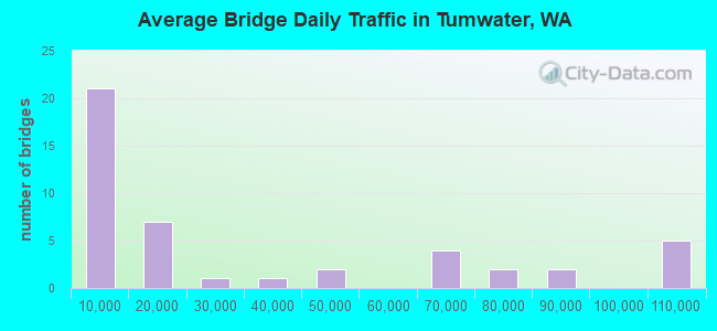
- 1,423,833Total average daily traffic
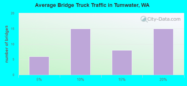
- 161,367Total average daily truck traffic
- National Bridge Inventory (NBI) Registered Bridges for Tumwater
- No street view available for this location
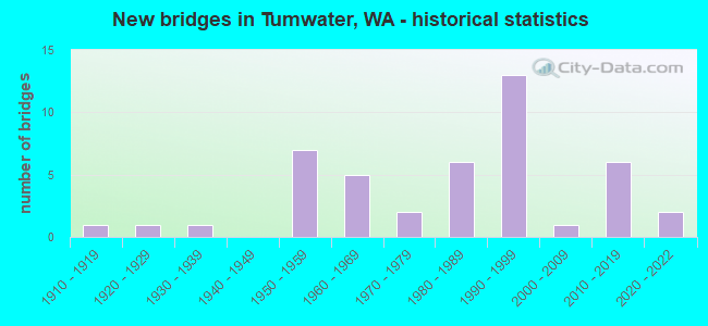
- New bridges - historical statistics
- 11910-1919
- 11920-1929
- 11930-1939
- 71950-1959
- 51960-1969
- 21970-1979
- 61980-1989
- 131990-1999
- 12000-2009
- 62010-2019
- 22020-2022
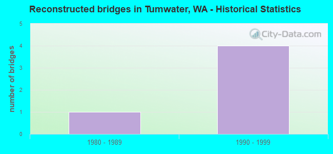
- Reconstructed bridges - Historical Statistics
- 11980-1989
- 41990-1999
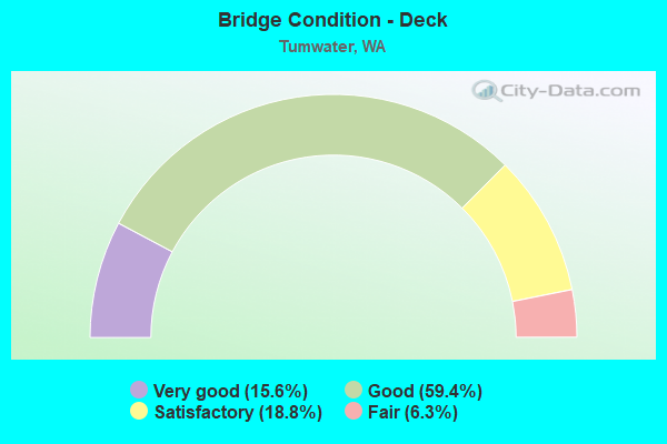
- Bridge Condition - Deck
- 15.6%Very good
- 59.4%Good
- 18.8%Satisfactory
- 6.3%Fair
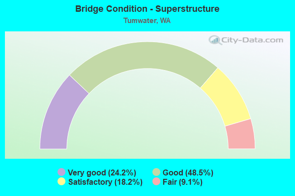
- Bridge Condition - Superstructure
- 24.2%Very good
- 48.5%Good
- 18.2%Satisfactory
- 9.1%Fair
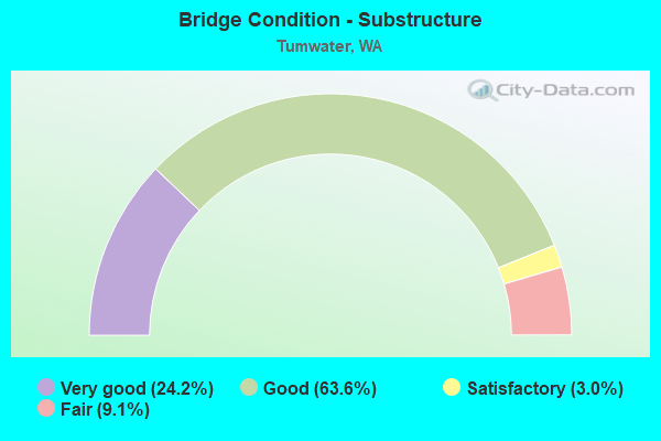
- Bridge Condition - Substructure
- 24.2%Very good
- 63.6%Good
- 3.0%Satisfactory
- 9.1%Fair
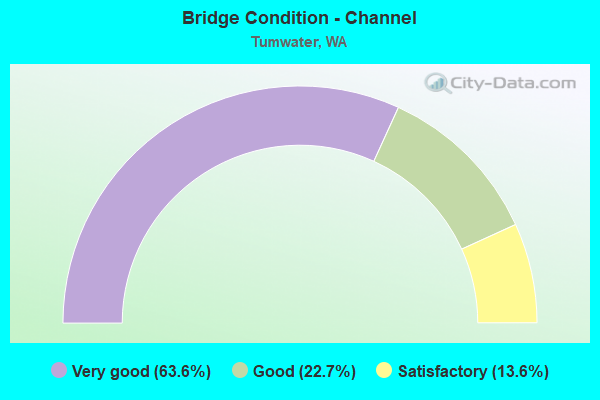
- Bridge Condition - Channel
- 63.6%Very good
- 22.7%Good
- 13.6%Satisfactory
Find on map >> Show street view
Structure Number: 13384B, Location: 5.0 N JCT SR 121 (Lat: 47.020047, Lng: -122.906908), Route carried "under" structure: Ramp Interstate 5, Year Built: 1990, Structure Length: 0. m, Average Daily Traffic: 3,050 (year 2019), Truck Traffic: 4%, Features Intersected: S-S RAMP, I-5, Facility Carried by Structure: N-S RAMP, US 101
Minimum Vertical Clearance: 5.44m (17.85ft), Kilometerpoint: 0.241, Lanes on structure: 1, Lanes under structure: 1, Material/Design: Prestressed concrete continuous, Design/Construction: Box Beam or Girders - Multiple, Length of Maximum Span: 36.0m (118.1ft)
Find on map >> Show street view
Structure Number: 13692A, Location: 3.5 N JCT SR 121 (Lat: 46.999944, Lng: -122.912806), Route carried "under" structure: Interstate 5, Year Built: 1991, Structure Length: 0. m, Average Daily Traffic: 89,694 (year 2019), Truck Traffic: 12%, Features Intersected: I-5, Facility Carried by Structure: TROSPER RD
Minimum Vertical Clearance: 5.00m (16.40ft), Kilometerpoint: 165.424, Lanes on structure: 5, Lanes under structure: 8, Material/Design: Prestressed concrete continuous, Design/Construction: Box Beam or Girders - Single/Spread, Length of Maximum Span: 37.8m (124.0ft)
Find on map >> Show street view
Structure Number: 13701A, Location: 2.4 N JCT SR 121 (Lat: 46.985611, Lng: -122.923389), Route carried "under" structure: Interstate 5, Year Built: 1990, Structure Length: 0. m, Average Daily Traffic: 72,659 (year 2019), Truck Traffic: 15%, Features Intersected: I-5, Facility Carried by Structure: ISRAEL RD
Minimum Vertical Clearance: 5.16m (16.93ft), Kilometerpoint: 163.622, Lanes on structure: 2, Lanes under structure: 7, Material/Design: Prestressed concrete continuous, Design/Construction: Box Beam or Girders - Single/Spread, Length of Maximum Span: 35.4m (116.1ft)
Find on map >> Show street view
Structure Number: 17465D, Location: JCT I-5 (Lat: 46.896472, Lng: -122.960722), Route carried "under" structure: State highway 121, Year Built: 2010, Structure Length: 0. m, Average Daily Traffic: 4,213 (year 2019), Truck Traffic: 9%, Features Intersected: SR 121 & RAILROAD, Facility Carried by Structure: I-5
Minimum Vertical Clearance: 7.04m (23.10ft), Kilometerpoint: 0.016, Lanes on structure: 8, Lanes under structure: 2, Material/Design: Prestressed concrete continuous, Design/Construction: Stringer/Multi-beam, Length of Maximum Span: 22.9m (75.1ft)