Bridge Statistics for Tyler, Texas (TX)
Condition, Traffic, Stress, Structural Evaluation, Project Costs
- National Bridge Inventory (NBI) Statistics
- 200Number of bridges
- 3,009ft / 917mTotal length
- $4,231,000Total costs
- 1,827,405Total average daily traffic
- 187,425Total average daily truck traffic
- National Bridge Inventory (NBI) Registered Bridges for Tyler
- No street view available for this location
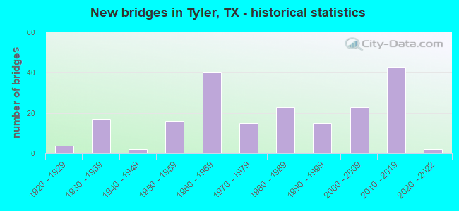
- New bridges - historical statistics
- 41920-1929
- 171930-1939
- 21940-1949
- 161950-1959
- 401960-1969
- 151970-1979
- 231980-1989
- 151990-1999
- 232000-2009
- 432010-2019
- 22020-2022
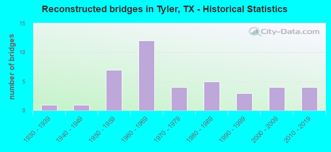
- Reconstructed bridges - Historical Statistics
- 11930-1939
- 11940-1949
- 71950-1959
- 121960-1969
- 41970-1979
- 51980-1989
- 31990-1999
- 42000-2009
- 42010-2019
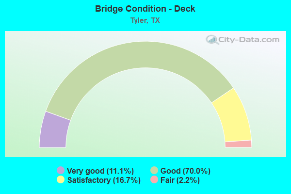
- Bridge Condition - Deck
- 11.1%Very good
- 70.0%Good
- 16.7%Satisfactory
- 2.2%Fair
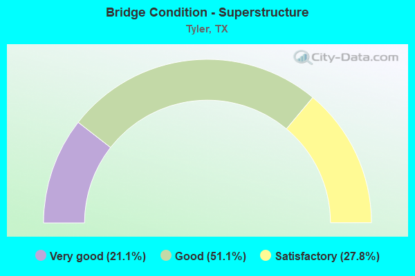
- Bridge Condition - Superstructure
- 21.1%Very good
- 51.1%Good
- 27.8%Satisfactory
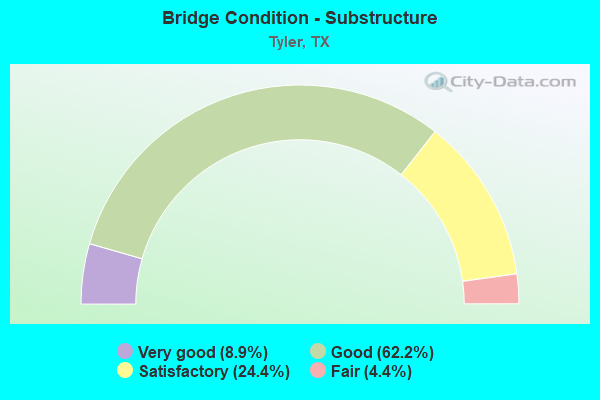
- Bridge Condition - Substructure
- 8.9%Very good
- 62.2%Good
- 24.4%Satisfactory
- 4.4%Fair
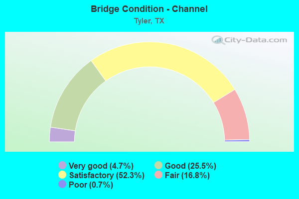
- Bridge Condition - Channel
- 4.7%Very good
- 25.5%Good
- 52.3%Satisfactory
- 16.8%Fair
- 0.7%Poor
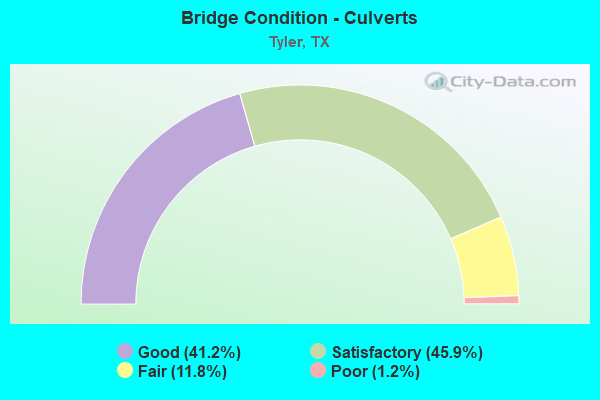
- Bridge Condition - Culverts
- 41.2%Good
- 45.9%Satisfactory
- 11.8%Fair
- 1.2%Poor
Find on map >> Show street view
Structure Number: 102120049505166, Location: 3.1 MI E OF FM 14 (Lat: 32.451839, Lng: -95.231364), Route carried "on" structure: State highway 2015, Year Built: 1964, Status: Open, Structure Length: 6.83m (22.41ft), Average Daily Traffic: 2,200 (year 2013), Truck Traffic: 6%, Average Future Daily Traffic: 3,080 (year 2033), Design Load: H 15, Features Intersected: IH 20
Minimum Vertical Clearance: 30+ m (98+ ft), Kilometerpoint: 7.870, Lanes on structure: 2, Lanes under structure: 4, Owner: State Highway Agency, Approaching Roadway Width: 8.5m (27.9ft), Skew: 1 degrees, Material/Design: Steel continuous, Design/Construction: Stringer/Multi-beam, Number Of Spans In Main Unit: 4, Length of Maximum Span: 19.8m (65.0ft), Curb-To-Curb Width: 8.6m (28.2ft), Out-to-Out Width: 9.4m (30.8ft)
Condition: Deck: Good, Superstructure: Satisfactory, Substructure: Good, Operating Rating: 40.8 metric tons, Method Used To Determine Operating Rating: Load Factor (LF), Inventory Rating: 24.5 metric tons, Method Used To Determine Inventory Rating: Load Factor (LF), Structural Evaluation: Equal to present minimum criteria, Deck Geometry: Meets minimum limits, Underclear: High priority of corrective action, Approach Roadway Alignment: Equal to present desirable criteria, Length Of Structure Improvement: 6.83m (22.41ft), Designated Inspection Frequency: Every 24 months, Inspection Date: March 2021, Bridge Improvement Cost: $13,000, Roadway Improvement Cost: $3,000, Total Project Cost: $16,000, Deck Structure Type: Concrete Cast-file-Place, Wearing Surface/Protective System: Wearing Surface: Bituminous
Find on map >> Show street view
Structure Number: 102120049505167, Location: 9.595 MI E OF US 69 (Lat: 32.451928, Lng: -95.229800), Route carried "on" structure: Interstate 20, Year Built: 1964, Status: Open, Structure Length: 0.70m (2.30ft), Average Daily Traffic: 32,013 (year 2020), Truck Traffic: 38%, Average Future Daily Traffic: 32,980 (year 2033), Design Load: HS 20, Features Intersected: WIGGINS CREEK BRANCH
Minimum Vertical Clearance: 30+ m (98+ ft), Kilometerpoint: 34.928, Lanes on structure: 4, Owner: State Highway Agency, Approaching Roadway Width: 23.2m (76.1ft), Skew: 30 degrees, Material/Design: Concrete, Design/Construction: Culvert, Number Of Spans In Main Unit: 3, Length of Maximum Span: 2.1m (6.9ft), Curb-To-Curb Width: 24.0m (78.7ft), Out-to-Out Width: 42.5m (139.4ft)
Condition: Channel: Satisfactory, Culverts: Satisfactory, Operating Rating: 39.9 metric tons, Method Used To Determine Operating Rating: Load Factor (LF), Inventory Rating: 23.6 metric tons, Method Used To Determine Inventory Rating: Load Factor (LF), Structural Evaluation: Somewhat better than minimum adequacy, Deck Geometry: Superior to present desirable criteria, Waterway Adequacy: Superior to present desirable criteria, Approach Roadway Alignment: Equal to present desirable criteria, Designated Inspection Frequency: Every 24 months, Inspection Date: March 2021
Find on map >> Show street view
Structure Number: 102120049505168, Location: 11.7 MI E OF US 69 (Lat: 32.450047, Lng: -95.190108), Route carried "on" structure: Interstate 20, Year Built: 1964, Year Reconstructed: 2004, Status: Open, Structure Length: 0.67m (2.20ft), Average Daily Traffic: 32,013 (year 2020), Truck Traffic: 38%, Average Future Daily Traffic: 32,980 (year 2033), Features Intersected: WIGGINS CREEK BRANCH
Minimum Vertical Clearance: 30+ m (98+ ft), Kilometerpoint: 38.613, Lanes on structure: 4, Owner: State Highway Agency, Approaching Roadway Width: 23.2m (76.1ft), Skew: 30 degrees, Material/Design: Concrete, Design/Construction: Culvert, Number Of Spans In Main Unit: 2, Length of Maximum Span: 3.0m (9.8ft)
Condition: Channel: Satisfactory, Culverts: Satisfactory, Operating Rating: 32.7 metric tons, Method Used To Determine Operating Rating: Field evaluation and documented engineering judgment, Inventory Rating: 24.5 metric tons, Method Used To Determine Inventory Rating: Field evaluation and documented engineering judgment, Structural Evaluation: Equal to present minimum criteria, Waterway Adequacy: Equal to present minimum criteria, Approach Roadway Alignment: Equal to present desirable criteria, Designated Inspection Frequency: Every 24 months, Inspection Date: March 2021
Find on map >> Show street view
Structure Number: 102120049505169, Location: 11.7 MI E OF US 69 (Lat: 32.450803, Lng: -95.189836), Route carried "on" structure: Ramp Interstate 20, Year Built: 1964, Status: Open, Structure Length: 0.67m (2.20ft), Average Daily Traffic: 2,350 (year 2013), Truck Traffic: 38%, Average Future Daily Traffic: 3,290 (year 2033), Features Intersected: WIGGINS CREEK BRANCH
Minimum Vertical Clearance: 30+ m (98+ ft), Kilometerpoint: 38.516, Lanes on structure: 1, Owner: State Highway Agency, Approaching Roadway Width: 6.7m (22.0ft), Material/Design: Concrete, Design/Construction: Culvert, Number Of Spans In Main Unit: 2, Length of Maximum Span: 3.0m (9.8ft)
Condition: Channel: Satisfactory, Culverts: Good, Operating Rating: 39.9 metric tons, Method Used To Determine Operating Rating: Load Factor (LF), Inventory Rating: 23.6 metric tons, Method Used To Determine Inventory Rating: Load Factor (LF), Structural Evaluation: Somewhat better than minimum adequacy, Waterway Adequacy: Equal to present minimum criteria, Approach Roadway Alignment: Equal to present desirable criteria, Designated Inspection Frequency: Every 24 months, Inspection Date: March 2021
Find on map >> Show street view
Structure Number: 10212004950517, Location: 11.7 MI E OF US 69 (Lat: 32.449614, Lng: -95.190353), Route carried "on" structure: Ramp Interstate 20, Year Built: 1964, Status: Open, Structure Length: 0.67m (2.20ft), Average Daily Traffic: 2,350 (year 2013), Truck Traffic: 38%, Average Future Daily Traffic: 3,290 (year 2033), Features Intersected: WIGGINS CREEK BRANCH
Minimum Vertical Clearance: 30+ m (98+ ft), Kilometerpoint: 38.520, Lanes on structure: 1, Owner: State Highway Agency, Approaching Roadway Width: 6.7m (22.0ft), Material/Design: Concrete, Design/Construction: Culvert, Number Of Spans In Main Unit: 2, Length of Maximum Span: 3.0m (9.8ft)
Condition: Channel: Satisfactory, Culverts: Satisfactory, Operating Rating: 32.7 metric tons, Method Used To Determine Operating Rating: Field evaluation and documented engineering judgment, Inventory Rating: 24.5 metric tons, Method Used To Determine Inventory Rating: Field evaluation and documented engineering judgment, Structural Evaluation: Equal to present minimum criteria, Waterway Adequacy: Equal to present minimum criteria, Approach Roadway Alignment: Equal to present desirable criteria, Designated Inspection Frequency: Every 24 months, Inspection Date: March 2021, Bridge Improvement Cost: $618,000, Roadway Improvement Cost: $18,000, Total Project Cost: $636,000
Find on map >> Show street view
Structure Number: 102120049505171, Location: 2.5 MI E OF FM 2015 (Lat: 32.449589, Lng: -95.188400), Route carried "on" structure: State highway 155, Year Built: 1964, Status: Open, Structure Length: 7.38m (24.21ft), Average Daily Traffic: 7,270 (year 2013), Truck Traffic: 10%, Average Future Daily Traffic: 10,180 (year 2033), Design Load: H 20, Features Intersected: IH 20
Minimum Vertical Clearance: 30+ m (98+ ft), Kilometerpoint: 13.443, Lanes on structure: 2, Lanes under structure: 4, Owner: State Highway Agency, Approaching Roadway Width: 12.2m (40.0ft), Skew: 2 degrees, Material/Design: Steel continuous, Design/Construction: Stringer/Multi-beam, Number Of Spans In Main Unit: 4, Length of Maximum Span: 19.8m (65.0ft), Curb-To-Curb Width: 12.8m (42.0ft), Out-to-Out Width: 13.4m (44.0ft)
Condition: Deck: Good, Superstructure: Satisfactory, Substructure: Satisfactory, Operating Rating: 60.8 metric tons, Method Used To Determine Operating Rating: Load Factor (LF), Inventory Rating: 36.3 metric tons, Method Used To Determine Inventory Rating: Load Factor (LF), Structural Evaluation: Equal to present minimum criteria, Deck Geometry: Somewhat better than minimum adequacy, Underclear: Meets minimum limits, Approach Roadway Alignment: Equal to present desirable criteria, Designated Inspection Frequency: Every 24 months, Inspection Date: March 2021, Deck Structure Type: Concrete Cast-file-Place, Wearing Surface/Protective System: Wearing Surface: Bituminous
Find on map >> Show street view
Structure Number: 102120049505172, Location: 0.35 MI E OF SH 155 (Lat: 32.448142, Lng: -95.182489), Route carried "on" structure: State highway 3311, Year Built: 1964, Status: Open, Structure Length: 6.77m (22.21ft), Average Daily Traffic: 190 (year 2013), Truck Traffic: 24%, Average Future Daily Traffic: 260 (year 2033), Design Load: H 20, Features Intersected: IH 20
Minimum Vertical Clearance: 30+ m (98+ ft), Kilometerpoint: 2.963, Lanes on structure: 2, Lanes under structure: 4, Owner: State Highway Agency, Approaching Roadway Width: 6.7m (22.0ft), Material/Design: Steel continuous, Design/Construction: Stringer/Multi-beam, Number Of Spans In Main Unit: 2, Number Of Approach Spans: 2, Length of Maximum Span: 19.5m (64.0ft), Curb-To-Curb Width: 7.3m (24.0ft), Out-to-Out Width: 8.3m (27.2ft)
Condition: Deck: Good, Superstructure: Satisfactory, Substructure: Good, Operating Rating: 68.0 metric tons, Method Used To Determine Operating Rating: Load Factor (LF), Inventory Rating: 40.8 metric tons, Method Used To Determine Inventory Rating: Load Factor (LF), Structural Evaluation: Equal to present minimum criteria, Deck Geometry: Somewhat better than minimum adequacy, Underclear: High priority of corrective action, Approach Roadway Alignment: Equal to present desirable criteria, Length Of Structure Improvement: 6.77m (22.21ft), Designated Inspection Frequency: Every 24 months, Inspection Date: March 2021, Bridge Improvement Cost: $11,000, Roadway Improvement Cost: $3,000, Total Project Cost: $14,000, Deck Structure Type: Concrete Cast-file-Place
Find on map >> Show street view
Structure Number: 102120049505313, Location: 1.0 MI E OF SH 155 (Lat: 32.447514, Lng: -95.172186), Route carried "on" structure: Interstate 20, Year Built: 2003, Status: Open, Structure Length: 14.33m (47.01ft), Average Daily Traffic: 15,947 (year 2020), Truck Traffic: 29%, Average Future Daily Traffic: 17,280 (year 2033), Design Load: HL 93, Features Intersected: HARRIS CREEK
Minimum Vertical Clearance: 30+ m (98+ ft), Kilometerpoint: 40.337, Lanes on structure: 2, Owner: State Highway Agency, Approaching Roadway Width: 11.0m (36.1ft), Material/Design: Prestressed concrete, Design/Construction: Stringer/Multi-beam, Number Of Spans In Main Unit: 4, Length of Maximum Span: 38.1m (125.0ft), Curb-To-Curb Width: 11.5m (37.7ft), Out-to-Out Width: 12.2m (40.0ft)
Condition: Deck: Good, Superstructure: Very good, Substructure: Good, Channel: Good, Operating Rating: 54.4 metric tons, Method Used To Determine Operating Rating: Assigned ratings based on Load and Resistance Factor Design (LRFD) reported in metric tons, Inventory Rating: 32.7 metric tons, Method Used To Determine Inventory Rating: Assigned ratings based on Load and Resistance Factor Design (LRFD) reported in metric tons, Structural Evaluation: Better than present minimum criteria, Deck Geometry: Somewhat better than minimum adequacy, Waterway Adequacy: Superior to present desirable criteria, Approach Roadway Alignment: Equal to present desirable criteria, Designated Inspection Frequency: Every 24 months, Inspection Date: March 2021, Deck Structure Type: Concrete Precast Panels, Wearing Surface/Protective System: Wearing Surface: Monolithic Concrete
Find on map >> Show street view
Structure Number: 102120049505314, Location: 1.0 MI E OF SH 155 (Lat: 32.447239, Lng: -95.172144), Route carried "on" structure: Interstate 20, Year Built: 2003, Status: Open, Structure Length: 14.33m (47.01ft), Average Daily Traffic: 16,142 (year 2020), Truck Traffic: 29%, Average Future Daily Traffic: 17,280 (year 2033), Design Load: HL 93, Features Intersected: HARRIS CREEK
Minimum Vertical Clearance: 30+ m (98+ ft), Kilometerpoint: 40.337, Lanes on structure: 2, Owner: State Highway Agency, Approaching Roadway Width: 11.0m (36.1ft), Material/Design: Prestressed concrete, Design/Construction: Stringer/Multi-beam, Number Of Spans In Main Unit: 4, Length of Maximum Span: 38.1m (125.0ft), Curb-To-Curb Width: 11.5m (37.7ft), Out-to-Out Width: 12.2m (40.0ft)
Condition: Deck: Good, Superstructure: Very good, Substructure: Good, Channel: Good, Operating Rating: 54.4 metric tons, Method Used To Determine Operating Rating: Assigned ratings based on Load and Resistance Factor Design (LRFD) reported in metric tons, Inventory Rating: 32.7 metric tons, Method Used To Determine Inventory Rating: Assigned ratings based on Load and Resistance Factor Design (LRFD) reported in metric tons, Structural Evaluation: Better than present minimum criteria, Deck Geometry: Somewhat better than minimum adequacy, Waterway Adequacy: Superior to present desirable criteria, Approach Roadway Alignment: Equal to present desirable criteria, Designated Inspection Frequency: Every 24 months, Inspection Date: March 2021, Deck Structure Type: Concrete Precast Panels, Wearing Surface/Protective System: Wearing Surface: Monolithic Concrete
Find on map >> Show street view
Structure Number: 102120050502023, Location: 1.0 MI N OF FM 3271 (Lat: 32.426356, Lng: -95.401428), Route carried "on" structure: State highway 110, Year Built: 1984, Status: Open, Structure Length: 0.67m (2.20ft), Average Daily Traffic: 3,171 (year 2020), Truck Traffic: 10%, Average Future Daily Traffic: 4,930 (year 2033), Design Load: HS 20, Features Intersected: CHINQUAPIN CREEK
Minimum Vertical Clearance: 30+ m (98+ ft), Kilometerpoint: 23.830, Lanes on structure: 2, Owner: State Highway Agency, Approaching Roadway Width: 12.2m (40.0ft), Skew: 9 degrees, Material/Design: Concrete, Design/Construction: Culvert, Number Of Spans In Main Unit: 2, Length of Maximum Span: 3.0m (9.8ft), Curb-To-Curb Width: 12.9m (42.3ft), Out-to-Out Width: 36.1m (118.4ft)
Condition: Channel: Satisfactory, Culverts: Good, Operating Rating: 39.9 metric tons, Method Used To Determine Operating Rating: Load Factor (LF), Inventory Rating: 23.6 metric tons, Method Used To Determine Inventory Rating: Load Factor (LF), Structural Evaluation: Equal to present minimum criteria, Deck Geometry: Equal to present minimum criteria, Waterway Adequacy: Equal to present minimum criteria, Approach Roadway Alignment: Equal to present desirable criteria, Designated Inspection Frequency: Every 48 months, Inspection Date: March 2019, Deck Structure Type: Concrete Cast-file-Place, Wearing Surface/Protective System: Wearing Surface: Bituminous
Find on map >> Show street view
Structure Number: 102120050502024, Location: 0.5 MI S OF FM 2016 (Lat: 32.389358, Lng: -95.364931), Route carried "on" structure: State highway 110, Year Built: 1991, Status: Open, Structure Length: 8.23m (27.00ft), Average Daily Traffic: 7,309 (year 2020), Truck Traffic: 7%, Average Future Daily Traffic: 9,840 (year 2033), Design Load: HS 20, Features Intersected: BLACK FORK CREEK
Minimum Vertical Clearance: 30+ m (98+ ft), Kilometerpoint: 29.618, Lanes on structure: 2, Owner: State Highway Agency, Approaching Roadway Width: 9.1m (29.9ft), Skew: 2 degrees, Material/Design: Prestressed concrete, Design/Construction: Box Beam or Girders - Multiple, Number Of Spans In Main Unit: 8, Length of Maximum Span: 10.7m (35.1ft), Curb-To-Curb Width: 13.3m (43.6ft), Out-to-Out Width: 14.1m (46.3ft)
Condition: Deck: Very good, Superstructure: Good, Substructure: Good, Channel: Satisfactory, Operating Rating: 54.4 metric tons, Method Used To Determine Operating Rating: Assigned rating based on Load Factor Design (LFD) reported in metric tons, Inventory Rating: 32.7 metric tons, Method Used To Determine Inventory Rating: Assigned rating based on Load Factor Design (LFD) reported in metric tons, Structural Evaluation: Better than present minimum criteria, Deck Geometry: Somewhat better than minimum adequacy, Waterway Adequacy: Superior to present desirable criteria, Approach Roadway Alignment: Equal to present desirable criteria, Length Of Structure Improvement: 8.23m (27.00ft), Designated Inspection Frequency: Every 24 months, Inspection Date: March 2021, Deck Structure Type: Concrete Cast-file-Place, Wearing Surface/Protective System: Wearing Surface: Bituminous
Find on map >> Show street view
Structure Number: 102120050502025, Location: 0.5 MI W OF LP 323 (Lat: 32.370575, Lng: -95.351314), Route carried "on" structure: State highway 110, Year Built: 1991, Status: Open, Structure Length: 1.40m (4.59ft), Average Daily Traffic: 7,057 (year 2018), Truck Traffic: 9%, Average Future Daily Traffic: 12,970 (year 2033), Design Load: HS 20, Features Intersected: WILLOW CREEK
Minimum Vertical Clearance: 30+ m (98+ ft), Kilometerpoint: 32.348, Lanes on structure: 2, Owner: State Highway Agency, Approaching Roadway Width: 8.5m (27.9ft), Skew: 4 degrees, Material/Design: Concrete, Design/Construction: Culvert, Number Of Spans In Main Unit: 3, Length of Maximum Span: 3.0m (9.8ft), Curb-To-Curb Width: 12.6m (41.3ft), Out-to-Out Width: 19.4m (63.6ft)
Condition: Channel: Satisfactory, Culverts: Satisfactory, Operating Rating: 39.9 metric tons, Method Used To Determine Operating Rating: Load Factor (LF), Inventory Rating: 23.6 metric tons, Method Used To Determine Inventory Rating: Load Factor (LF), Structural Evaluation: Somewhat better than minimum adequacy, Deck Geometry: Somewhat better than minimum adequacy, Waterway Adequacy: Superior to present desirable criteria, Approach Roadway Alignment: Equal to present desirable criteria, Length Of Structure Improvement: 1.01m (3.31ft), Designated Inspection Frequency: Every 48 months, Inspection Date: March 2019, Deck Structure Type: Concrete Cast-file-Place, Wearing Surface/Protective System: Wearing Surface: Bituminous
Find on map >> Show street view
Structure Number: 102120088904015, Location: 0.05 MI W OF US 69 (Lat: 32.205947, Lng: -95.318931), Route carried "on" structure: State highway 346, Year Built: 1991, Status: Open, Structure Length: 1.86m (6.10ft), Average Daily Traffic: 4,885 (year 2020), Truck Traffic: 5%, Average Future Daily Traffic: 6,950 (year 2033), Design Load: HS 20, Features Intersected: HENSHAW CREEK
Minimum Vertical Clearance: 30+ m (98+ ft), Kilometerpoint: 2.869, Lanes on structure: 2, Owner: State Highway Agency, Approaching Roadway Width: 8.5m (27.9ft), Skew: 1 degrees, Material/Design: Concrete, Design/Construction: Culvert, Number Of Spans In Main Unit: 6, Length of Maximum Span: 2.7m (8.9ft), Curb-To-Curb Width: 8.1m (26.6ft), Out-to-Out Width: 20.8m (68.2ft)
Condition: Channel: Good, Culverts: Good, Operating Rating: 39.9 metric tons, Method Used To Determine Operating Rating: Load Factor (LF), Inventory Rating: 23.6 metric tons, Method Used To Determine Inventory Rating: Load Factor (LF), Structural Evaluation: Equal to present minimum criteria, Deck Geometry: High priority of corrective action, Waterway Adequacy: Equal to present minimum criteria, Approach Roadway Alignment: Equal to present desirable criteria, Designated Inspection Frequency: Every 24 months, Inspection Date: March 2021, Deck Structure Type: Concrete Cast-file-Place, Wearing Surface/Protective System: Wearing Surface: Bituminous
Find on map >> Show street view
Structure Number: 102120088904016, Location: 0.4 MI E OF US 69 (Lat: 32.207219, Lng: -95.311850), Route carried "on" structure: State highway 346, Year Built: 1991, Status: Open, Structure Length: 5.97m (19.59ft), Average Daily Traffic: 5,468 (year 2013), Truck Traffic: 5%, Average Future Daily Traffic: 6,950 (year 2033), Design Load: HS 20, Features Intersected: WEST MUD CREEK
Minimum Vertical Clearance: 30+ m (98+ ft), Kilometerpoint: 3.587, Lanes on structure: 2, Owner: State Highway Agency, Approaching Roadway Width: 7.9m (25.9ft), Skew: 3 degrees, Material/Design: Prestressed concrete, Number Of Spans In Main Unit: 6, Length of Maximum Span: 10.7m (35.1ft), Curb-To-Curb Width: 13.2m (43.3ft), Out-to-Out Width: 14.1m (46.3ft)
Condition: Deck: Very good, Superstructure: Good, Substructure: Good, Channel: Satisfactory, Operating Rating: 54.4 metric tons, Method Used To Determine Operating Rating: Assigned rating based on Load Factor Design (LFD) reported in metric tons, Inventory Rating: 32.7 metric tons, Method Used To Determine Inventory Rating: Assigned rating based on Load Factor Design (LFD) reported in metric tons, Structural Evaluation: Better than present minimum criteria, Deck Geometry: Somewhat better than minimum adequacy, Waterway Adequacy: Superior to present desirable criteria, Approach Roadway Alignment: Equal to present desirable criteria, Designated Inspection Frequency: Every 24 months, Inspection Date: March 2021, Deck Structure Type: Concrete Precast Panels, Wearing Surface/Protective System: Wearing Surface: Bituminous
Find on map >> Show street view
Structure Number: 102120088904017, Location: 1.1 MI E OF US 69 (Lat: 32.209103, Lng: -95.301228), Route carried "on" structure: State highway 346, Year Built: 1991, Status: Open, Structure Length: 1.65m (5.41ft), Average Daily Traffic: 5,468 (year 2013), Truck Traffic: 5%, Average Future Daily Traffic: 8,040 (year 2033), Design Load: HS 20, Features Intersected: SHACKLEFORD CREEK
Minimum Vertical Clearance: 30+ m (98+ ft), Kilometerpoint: 4.661, Lanes on structure: 2, Owner: State Highway Agency, Approaching Roadway Width: 7.9m (25.9ft), Material/Design: Concrete, Design/Construction: Culvert, Number Of Spans In Main Unit: 5, Length of Maximum Span: 3.0m (9.8ft)
Condition: Channel: Satisfactory, Culverts: Good, Operating Rating: 39.9 metric tons, Method Used To Determine Operating Rating: Load Factor (LF), Inventory Rating: 23.6 metric tons, Method Used To Determine Inventory Rating: Load Factor (LF), Structural Evaluation: Somewhat better than minimum adequacy, Waterway Adequacy: Equal to present minimum criteria, Approach Roadway Alignment: Equal to present desirable criteria, Designated Inspection Frequency: Every 48 months, Inspection Date: March 2021
Find on map >> Show street view
Structure Number: 102120116301006, Location: 0.3 MI S OF SH 31 (Lat: 32.350092, Lng: -95.214742), Route carried "on" structure: State highway 850, Year Built: 1991, Status: Open, Structure Length: 2.77m (9.09ft), Average Daily Traffic: 3,226 (year 2020), Truck Traffic: 9%, Average Future Daily Traffic: 3,950 (year 2033), Design Load: HS 20, Features Intersected: HARRIS CREEK
Minimum Vertical Clearance: 30+ m (98+ ft), Kilometerpoint: 4.706, Lanes on structure: 2, Owner: State Highway Agency, Approaching Roadway Width: 9.1m (29.9ft), Material/Design: Concrete, Design/Construction: Stringer/Multi-beam, Number Of Spans In Main Unit: 3, Length of Maximum Span: 9.1m (29.9ft), Curb-To-Curb Width: 13.4m (44.0ft), Out-to-Out Width: 14.0m (45.9ft)
Condition: Deck: Good, Superstructure: Good, Substructure: Satisfactory, Channel: Good, Operating Rating: 68.0 metric tons, Method Used To Determine Operating Rating: Load Factor (LF), Inventory Rating: 40.8 metric tons, Method Used To Determine Inventory Rating: Load Factor (LF), Structural Evaluation: Equal to present minimum criteria, Deck Geometry: Better than present minimum criteria, Waterway Adequacy: Superior to present desirable criteria, Approach Roadway Alignment: Equal to present desirable criteria, Designated Inspection Frequency: Every 24 months, Inspection Date: March 2021, Deck Structure Type: Concrete Cast-file-Place, Wearing Surface/Protective System: Wearing Surface: Monolithic Concrete
Find on map >> Show street view
Structure Number: 102120193402002, Location: 0.1 MI N OF IH 20 (Lat: 32.453314, Lng: -95.230936), Route carried "on" structure: State highway 2015, Year Built: 1960, Year Reconstructed: 1964, Status: Open, Structure Length: 1.31m (4.30ft), Average Daily Traffic: 2,822 (year 2019), Truck Traffic: 6%, Average Future Daily Traffic: 3,080 (year 2039), Design Load: HS 20, Features Intersected: WIGGINS CREEK
Minimum Vertical Clearance: 30+ m (98+ ft), Kilometerpoint: 7.755, Lanes on structure: 2, Owner: State Highway Agency, Approaching Roadway Width: 7.3m (24.0ft), Material/Design: Concrete, Design/Construction: Culvert, Number Of Spans In Main Unit: 4, Length of Maximum Span: 3.0m (9.8ft)
Condition: Channel: Satisfactory, Culverts: Satisfactory, Operating Rating: 39.9 metric tons, Method Used To Determine Operating Rating: Load Factor (LF), Inventory Rating: 23.6 metric tons, Method Used To Determine Inventory Rating: Load Factor (LF), Structural Evaluation: Equal to present minimum criteria, Waterway Adequacy: Equal to present minimum criteria, Approach Roadway Alignment: Equal to present desirable criteria, Designated Inspection Frequency: Every 24 months, Inspection Date: April 2021
Find on map >> Show street view
Structure Number: 102120193501003, Location: 1.2 MI W OF US 69 (Lat: 32.396958, Lng: -95.359667), Route carried "on" structure: State highway 2016, Year Built: 1991, Status: Open, Structure Length: 0.73m (2.40ft), Average Daily Traffic: 822 (year 2020), Truck Traffic: 11%, Average Future Daily Traffic: 860 (year 2033), Features Intersected: BLACK FORK CREEK BR
Minimum Vertical Clearance: 30+ m (98+ ft), Kilometerpoint: 0.830, Lanes on structure: 2, Owner: State Highway Agency, Approaching Roadway Width: 10.4m (34.1ft), Skew: 1 degrees, Material/Design: Concrete, Design/Construction: Culvert, Number Of Spans In Main Unit: 3, Length of Maximum Span: 2.1m (6.9ft), Curb-To-Curb Width: 10.8m (35.4ft), Out-to-Out Width: 15.0m (49.2ft)
Condition: Channel: Fair, Culverts: Good, Operating Rating: 32.7 metric tons, Method Used To Determine Operating Rating: Field evaluation and documented engineering judgment, Inventory Rating: 24.5 metric tons, Method Used To Determine Inventory Rating: Field evaluation and documented engineering judgment, Structural Evaluation: Equal to present minimum criteria, Deck Geometry: Equal to present minimum criteria, Waterway Adequacy: Equal to present minimum criteria, Approach Roadway Alignment: Equal to present desirable criteria, Length Of Structure Improvement: 0.73m (2.40ft), Designated Inspection Frequency: Every 24 months, Inspection Date: March 2021
Find on map >> Show street view
Structure Number: 102120207501001, Location: 0.4 MI W OF FM 14 (Lat: 32.390539, Lng: -95.292989), Route carried "on" structure: State highway 323, Year Built: 1956, Year Reconstructed: 1970, Status: Open, Structure Length: 0.67m (2.20ft), Average Daily Traffic: 15,160 (year 2018), Truck Traffic: 20%, Average Future Daily Traffic: 24,690 (year 2033), Features Intersected: BLACK FORK CRK BR
Minimum Vertical Clearance: 30+ m (98+ ft), Kilometerpoint: 34.372, Lanes on structure: 4, Owner: State Highway Agency, Approaching Roadway Width: 24.4m (80.1ft), Skew: 20 degrees, Material/Design: Concrete, Design/Construction: Culvert, Number Of Spans In Main Unit: 2, Length of Maximum Span: 3.0m (9.8ft)
Condition: Channel: Good, Culverts: Good, Operating Rating: 39.9 metric tons, Method Used To Determine Operating Rating: Load Factor (LF), Inventory Rating: 23.6 metric tons, Method Used To Determine Inventory Rating: Load Factor (LF), Structural Evaluation: Somewhat better than minimum adequacy, Waterway Adequacy: Equal to present minimum criteria, Approach Roadway Alignment: Equal to present desirable criteria, Length Of Structure Improvement: 0.67m (2.20ft), Designated Inspection Frequency: Every 24 months, Inspection Date: March 2021, Bridge Improvement Cost: $25,000, Roadway Improvement Cost: $8,000, Total Project Cost: $33,000
Find on map >> Show street view
Structure Number: 102120207501002, Location: 1.0 MI NE OF US 69 (Lat: 32.387353, Lng: -95.317708), Route carried "on" structure: State highway 323, Year Built: 1956, Status: Open, Structure Length: 4.63m (15.19ft), Average Daily Traffic: 7,249 (year 2018), Truck Traffic: 20%, Average Future Daily Traffic: 12,340 (year 2033), Features Intersected: BLACK FORK CREEK
Minimum Vertical Clearance: 30+ m (98+ ft), Kilometerpoint: 31.905, Lanes on structure: 2, Owner: State Highway Agency, Approaching Roadway Width: 11.6m (38.1ft), Material/Design: Concrete, Design/Construction: Stringer/Multi-beam, Number Of Spans In Main Unit: 5, Length of Maximum Span: 9.1m (29.9ft), Curb-To-Curb Width: 8.5m (27.9ft), Out-to-Out Width: 9.4m (30.8ft)
Condition: Deck: Good, Superstructure: Good, Substructure: Satisfactory, Channel: Good, Operating Rating: 68.0 metric tons, Method Used To Determine Operating Rating: Load Factor (LF), Inventory Rating: 40.8 metric tons, Method Used To Determine Inventory Rating: Load Factor (LF), Structural Evaluation: Equal to present minimum criteria, Deck Geometry: High priority of corrective action, Waterway Adequacy: Equal to present minimum criteria, Approach Roadway Alignment: Equal to present desirable criteria, Length Of Structure Improvement: 4.63m (15.19ft), Designated Inspection Frequency: Every 24 months, Inspection Date: March 2021, Bridge Improvement Cost: $9,000, Roadway Improvement Cost: $2,000, Total Project Cost: $11,000, Deck Structure Type: Concrete Cast-file-Place, Wearing Surface/Protective System: Wearing Surface: Bituminous
Find on map >> Show street view
Structure Number: 102120207501003, Location: 0.2 MI S OF SH 110 (Lat: 32.367119, Lng: -95.343231), Route carried "on" structure: State highway 323, Year Built: 1956, Year Reconstructed: 1967, Status: Open, Structure Length: 1.01m (3.31ft), Average Daily Traffic: 29,881 (year 2018), Truck Traffic: 20%, Average Future Daily Traffic: 42,680 (year 2033), Features Intersected: WILLOW CREEK
Minimum Vertical Clearance: 30+ m (98+ ft), Kilometerpoint: 28.196, Lanes on structure: 6, Owner: State Highway Agency, Approaching Roadway Width: 26.8m (87.9ft), Skew: 20 degrees, Material/Design: Concrete, Design/Construction: Culvert, Number Of Spans In Main Unit: 3, Length of Maximum Span: 3.0m (9.8ft), Curb or Sidewalk Widths: Left: 1.8m (5.9ft), Right: 1.8m (5.9ft)
Condition: Channel: Fair, Culverts: Satisfactory, Operating Rating: 39.9 metric tons, Method Used To Determine Operating Rating: Load Factor (LF), Inventory Rating: 23.6 metric tons, Method Used To Determine Inventory Rating: Load Factor (LF), Structural Evaluation: Somewhat better than minimum adequacy, Waterway Adequacy: Equal to present minimum criteria, Approach Roadway Alignment: Equal to present desirable criteria, Designated Inspection Frequency: Every 24 months, Inspection Date: March 2021
Find on map >> Show street view
Structure Number: 102120207501006, Location: 1.0 MI NE OF US 69 (Lat: 32.387239, Lng: -95.317439), Route carried "on" structure: State highway 323, Year Built: 1970, Status: Open, Structure Length: 5.21m (17.09ft), Average Daily Traffic: 7,912 (year 2018), Truck Traffic: 20%, Average Future Daily Traffic: 12,340 (year 2033), Design Load: HS 20, Features Intersected: BLACK FORK CREEK
Minimum Vertical Clearance: 30+ m (98+ ft), Kilometerpoint: 31.905, Lanes on structure: 2, Owner: State Highway Agency, Approaching Roadway Width: 11.6m (38.1ft), Skew: 4 degrees, Material/Design: Concrete, Design/Construction: Stringer/Multi-beam, Number Of Spans In Main Unit: 5, Length of Maximum Span: 10.4m (34.1ft), Curb-To-Curb Width: 12.2m (40.0ft), Out-to-Out Width: 12.9m (42.3ft)
Condition: Deck: Good, Superstructure: Good, Substructure: Satisfactory, Channel: Good, Operating Rating: 50.8 metric tons, Method Used To Determine Operating Rating: Load Factor (LF), Inventory Rating: 30.8 metric tons, Method Used To Determine Inventory Rating: Load Factor (LF), Structural Evaluation: Equal to present minimum criteria, Deck Geometry: Better than present minimum criteria, Waterway Adequacy: Equal to present minimum criteria, Approach Roadway Alignment: Equal to present desirable criteria, Designated Inspection Frequency: Every 24 months, Inspection Date: March 2021, Deck Structure Type: Concrete Cast-file-Place, Wearing Surface/Protective System: Wearing Surface: Bituminous
Find on map >> Show street view
Structure Number: 102120207502005, Location: 0.3 MI E OF US 69 (Lat: 32.302822, Lng: -95.294822), Route carried "on" structure: State highway 323, Year Built: 1957, Year Reconstructed: 1967, Status: Open, Structure Length: 2.04m (6.69ft), Average Daily Traffic: 33,347 (year 2018), Truck Traffic: 20%, Average Future Daily Traffic: 51,980 (year 2033), Features Intersected: WEST MUD CREEK
Minimum Vertical Clearance: 30+ m (98+ ft), Kilometerpoint: 4.989, Lanes on structure: 7, Owner: State Highway Agency, Approaching Roadway Width: 26.8m (87.9ft), Skew: 20 degrees, Material/Design: Concrete, Design/Construction: Culvert, Number Of Spans In Main Unit: 6, Length of Maximum Span: 3.0m (9.8ft), Curb-To-Curb Width: 25.8m (84.6ft), Out-to-Out Width: 37.0m (121.4ft)
Condition: Channel: Fair, Culverts: Satisfactory, Operating Rating: 32.7 metric tons, Method Used To Determine Operating Rating: Field evaluation and documented engineering judgment, Inventory Rating: 24.5 metric tons, Method Used To Determine Inventory Rating: Field evaluation and documented engineering judgment, Structural Evaluation: Equal to present minimum criteria, Deck Geometry: Meets minimum limits, Waterway Adequacy: Equal to present minimum criteria, Approach Roadway Alignment: Equal to present desirable criteria, Designated Inspection Frequency: Every 24 months, Inspection Date: March 2021, Deck Structure Type: Concrete Cast-file-Place, Wearing Surface/Protective System: Wearing Surface: Bituminous
Find on map >> Show street view
Structure Number: 102120207502007, Location: 1.0 MI W OF US 69 (Lat: 32.303386, Lng: -95.318644), Route carried "on" structure: State highway 323, Year Built: 1956, Year Reconstructed: 1998, Status: Open, Structure Length: 1.31m (4.30ft), Average Daily Traffic: 10,000 (year 2010), Truck Traffic: 8%, Average Future Daily Traffic: 12,340 (year 2030), Features Intersected: W MUD CR TR
Minimum Vertical Clearance: 30+ m (98+ ft), Kilometerpoint: 7.245, Lanes on structure: 6, Owner: State Highway Agency, Approaching Roadway Width: 29.3m (96.1ft), Skew: 20 degrees, Material/Design: Concrete, Design/Construction: Culvert, Number Of Spans In Main Unit: 5, Length of Maximum Span: 3.0m (9.8ft)
Condition: Channel: Satisfactory, Culverts: Satisfactory, Operating Rating: 32.7 metric tons, Method Used To Determine Operating Rating: Field evaluation and documented engineering judgment, Inventory Rating: 24.5 metric tons, Method Used To Determine Inventory Rating: Field evaluation and documented engineering judgment, Structural Evaluation: Equal to present minimum criteria, Waterway Adequacy: Equal to present minimum criteria, Approach Roadway Alignment: Equal to present desirable criteria, Designated Inspection Frequency: Every 24 months, Inspection Date: March 2021
Find on map >> Show street view
Structure Number: 102120255801001, Location: 2.2 MI E OF LP 323 (Lat: 32.314622, Lng: -95.230725), Route carried "on" structure: State highway 248, Year Built: 1962, Year Reconstructed: 2018, Status: Open, Structure Length: 1.49m (4.89ft), Average Daily Traffic: 7,291 (year 2020), Truck Traffic: 3%, Average Future Daily Traffic: 12,870 (year 2033), Design Load: HS 20, Features Intersected: GILLEY CR
Minimum Vertical Clearance: 30+ m (98+ ft), Kilometerpoint: 3.640, Lanes on structure: 5, Owner: State Highway Agency, Approaching Roadway Width: 22.6m (74.1ft), Skew: 9 degrees, Material/Design: Concrete, Design/Construction: Culvert, Number Of Spans In Main Unit: 5, Length of Maximum Span: 2.7m (8.9ft), Curb-To-Curb Width: 22.6m (74.1ft), Out-to-Out Width: 34.4m (112.9ft)
Condition: Channel: Satisfactory, Culverts: Satisfactory, Operating Rating: 39.9 metric tons, Method Used To Determine Operating Rating: Load Factor (LF), Inventory Rating: 23.6 metric tons, Method Used To Determine Inventory Rating: Load Factor (LF), Structural Evaluation: Somewhat better than minimum adequacy, Deck Geometry: Equal to present minimum criteria, Waterway Adequacy: Equal to present minimum criteria, Approach Roadway Alignment: Equal to present desirable criteria, Designated Inspection Frequency: Every 24 months, Inspection Date: March 2021, Deck Structure Type: Concrete Cast-file-Place, Wearing Surface/Protective System: Wearing Surface: Bituminous
Find on map >> Show street view
Structure Number: 102120279301002, Location: 0.8 MI W OF US 69 (Lat: 32.239186, Lng: -95.323906), Route carried "on" structure: State highway 2813, Year Built: 1987, Status: Open, Structure Length: 5.55m (18.21ft), Average Daily Traffic: 4,583 (year 2020), Truck Traffic: 5%, Average Future Daily Traffic: 6,680 (year 2033), Design Load: HS 20, Features Intersected: WEST MUD CREEK
Minimum Vertical Clearance: 30+ m (98+ ft), Kilometerpoint: 2.469, Lanes on structure: 2, Owner: State Highway Agency, Approaching Roadway Width: 8.5m (27.9ft), Material/Design: Concrete, Design/Construction: Stringer/Multi-beam, Number Of Spans In Main Unit: 6, Length of Maximum Span: 9.1m (29.9ft), Curb-To-Curb Width: 12.4m (40.7ft), Out-to-Out Width: 12.9m (42.3ft)
Condition: Deck: Good, Superstructure: Good, Substructure: Good, Channel: Satisfactory, Operating Rating: 68.0 metric tons, Method Used To Determine Operating Rating: Load Factor (LF), Inventory Rating: 40.8 metric tons, Method Used To Determine Inventory Rating: Load Factor (LF), Structural Evaluation: Better than present minimum criteria, Deck Geometry: Equal to present minimum criteria, Waterway Adequacy: Superior to present desirable criteria, Approach Roadway Alignment: Equal to present desirable criteria, Designated Inspection Frequency: Every 24 months, Inspection Date: March 2021, Deck Structure Type: Concrete Cast-file-Place
Find on map >> Show street view
Structure Number: 102120279301003, Location: 0.10 MI E OF FM 2493 (Lat: 32.234681, Lng: -95.347664), Route carried "on" structure: State highway 2813, Year Built: 1964, Year Reconstructed: 1987, Status: Open, Structure Length: 1.34m (4.40ft), Average Daily Traffic: 4,583 (year 2020), Truck Traffic: 5%, Average Future Daily Traffic: 6,680 (year 2033), Design Load: HS 20, Features Intersected: HENSHAW CREEK
Minimum Vertical Clearance: 30+ m (98+ ft), Kilometerpoint: 0.143, Lanes on structure: 2, Owner: State Highway Agency, Approaching Roadway Width: 8.2m (26.9ft), Material/Design: Concrete, Design/Construction: Culvert, Number Of Spans In Main Unit: 6, Length of Maximum Span: 1.8m (5.9ft)
Condition: Channel: Satisfactory, Culverts: Good, Operating Rating: 39.9 metric tons, Method Used To Determine Operating Rating: Load Factor (LF), Inventory Rating: 23.6 metric tons, Method Used To Determine Inventory Rating: Load Factor (LF), Structural Evaluation: Equal to present minimum criteria, Waterway Adequacy: Equal to present minimum criteria, Approach Roadway Alignment: Equal to present desirable criteria, Designated Inspection Frequency: Every 24 months, Inspection Date: March 2021
Find on map >> Show street view
Structure Number: 102120283301001, Location: 1.25 MI SE OF SH 31 (Lat: 32.317311, Lng: -95.386764), Route carried "on" structure: State highway 364, Year Built: 1966, Status: Open, Structure Length: 10.03m (32.91ft), Average Daily Traffic: 8,867 (year 2020), Truck Traffic: 3%, Average Future Daily Traffic: 10,700 (year 2033), Design Load: H 20, Features Intersected: STLSW RR/INDIAN CRK
Minimum Vertical Clearance: 30+ m (98+ ft), Kilometerpoint: 1.942, Lanes on structure: 3, Owner: State Highway Agency, Approaching Roadway Width: 13.4m (44.0ft), Skew: 1 degrees, Material/Design: Concrete, Design/Construction: Stringer/Multi-beam, Number Of Spans In Main Unit: 5, Number Of Approach Spans: 4, Length of Maximum Span: 12.5m (41.0ft), Curb-To-Curb Width: 13.1m (43.0ft), Out-to-Out Width: 14.1m (46.3ft)
Condition: Deck: Good, Superstructure: Good, Substructure: Satisfactory, Channel: Good, Operating Rating: 50.8 metric tons, Method Used To Determine Operating Rating: Load Factor (LF), Inventory Rating: 30.8 metric tons, Method Used To Determine Inventory Rating: Load Factor (LF), Structural Evaluation: Equal to present minimum criteria, Deck Geometry: Meets minimum limits, Underclear: Somewhat better than minimum adequacy, Waterway Adequacy: Superior to present desirable criteria, Approach Roadway Alignment: Equal to present desirable criteria, Designated Inspection Frequency: Every 24 months, Inspection Date: March 2021, Deck Structure Type: Concrete Cast-file-Place
Find on map >> Show street view
Structure Number: 102120348702012, Location: 2.0 MI E OF US 69 (Lat: 32.246831, Lng: -95.276125), Route carried "on" structure: State highway 756, Year Built: 2009, Status: Open, Structure Length: 10.36m (33.99ft), Average Daily Traffic: 543,000 (year 2013), Truck Traffic: 3%, Average Future Daily Traffic: 7,600 (year 2033), Design Load: HS 25 or greater, Features Intersected: TOLL 49
Minimum Vertical Clearance: 30+ m (98+ ft), Kilometerpoint: 6.838, Lanes on structure: 3, Lanes under structure: 3, Owner: State Highway Agency, Approaching Roadway Width: 14.0m (45.9ft), Material/Design: Prestressed concrete, Design/Construction: Stringer/Multi-beam, Number Of Spans In Main Unit: 2, Number Of Approach Spans: 2, Length of Maximum Span: 30.5m (100.1ft), Curb-To-Curb Width: 14.0m (45.9ft), Out-to-Out Width: 14.6m (47.9ft)
Condition: Deck: Very good, Superstructure: Good, Substructure: Good, Operating Rating: 68.0 metric tons, Method Used To Determine Operating Rating: Assigned rating based on Load Factor Design (LFD) reported in metric tons, Inventory Rating: 40.8 metric tons, Method Used To Determine Inventory Rating: Assigned rating based on Load Factor Design (LFD) reported in metric tons, Structural Evaluation: Better than present minimum criteria, Deck Geometry: Somewhat better than minimum adequacy, Underclear: Better than present minimum criteria, Approach Roadway Alignment: Equal to present desirable criteria, Designated Inspection Frequency: Every 24 months, Inspection Date: March 2021, Deck Structure Type: Concrete Precast Panels
Find on map >> Show street view
Structure Number: 102120AA0046002, Location: 2.7 MI NW OF SH 110 (Lat: 32.391617, Lng: -95.394597), Route carried "on" structure: County highway 46, Year Built: 1990, Status: Open, Structure Length: 3.69m (12.11ft), Average Daily Traffic: 1,447 (year 2020), Truck Traffic: 10%, Average Future Daily Traffic: 1,000 (year 2035), Design Load: HS 20, Features Intersected: BLACK FORK CREEK
Minimum Vertical Clearance: 30+ m (98+ ft), Kilometerpoint: 3.380, Lanes on structure: 2, Owner: County Highway Agency, Approaching Roadway Width: 6.7m (22.0ft), Material/Design: Concrete, Design/Construction: Stringer/Multi-beam, Number Of Spans In Main Unit: 4, Length of Maximum Span: 9.1m (29.9ft), Curb-To-Curb Width: 9.3m (30.5ft), Out-to-Out Width: 9.8m (32.2ft)
Condition: Deck: Satisfactory, Superstructure: Satisfactory, Substructure: Good, Channel: Satisfactory, Operating Rating: 68.0 metric tons, Method Used To Determine Operating Rating: Load Factor (LF), Inventory Rating: 40.8 metric tons, Method Used To Determine Inventory Rating: Load Factor (LF), Structural Evaluation: Equal to present minimum criteria, Deck Geometry: Somewhat better than minimum adequacy, Waterway Adequacy: Better than present minimum criteria, Approach Roadway Alignment: Equal to present minimum criteria, Designated Inspection Frequency: Every 24 months, Inspection Date: October 2021, Deck Structure Type: Concrete Cast-file-Place, Wearing Surface/Protective System: Wearing Surface: Bituminous
Find on map >> Show street view
Structure Number: 102120AA0132002, Location: 1.90 MI NW OF US 69 (Lat: 32.224153, Lng: -95.342417), Route carried "on" structure: County highway 132, Year Built: 2013, Status: Open, Structure Length: 1.52m (4.99ft), Average Daily Traffic: 150 (year 2011), Average Future Daily Traffic: 200 (year 2031), Design Load: HL 93, Features Intersected: HENSHAW CREEK
Minimum Vertical Clearance: 30+ m (98+ ft), Kilometerpoint: 0.644, Lanes on structure: 2, Owner: County Highway Agency, Approaching Roadway Width: 5.5m (18.0ft), Material/Design: Prestressed concrete, Design/Construction: Slab, Number Of Spans In Main Unit: 1, Length of Maximum Span: 15.2m (49.9ft), Curb-To-Curb Width: 7.3m (24.0ft), Out-to-Out Width: 7.9m (25.9ft)
Condition: Deck: Good, Superstructure: Very good, Substructure: Very good, Channel: Good, Operating Rating: 54.4 metric tons, Method Used To Determine Operating Rating: Assigned ratings based on Load and Resistance Factor Design (LRFD) reported in metric tons, Inventory Rating: 32.7 metric tons, Method Used To Determine Inventory Rating: Assigned ratings based on Load and Resistance Factor Design (LRFD) reported in metric tons, Structural Evaluation: Equal to present desirable criteria, Deck Geometry: Somewhat better than minimum adequacy, Waterway Adequacy: Better than present minimum criteria, Approach Roadway Alignment: Equal to present minimum criteria, Designated Inspection Frequency: Every 24 months, Inspection Date: October 2021, Deck Structure Type: Concrete Cast-file-Place
Find on map >> Show street view
Structure Number: 102120AA0137101, Location: 0.65 MI W OF US 69 (Lat: 32.211639, Lng: -95.327419), Route carried "on" structure: County highway 137, Year Built: 2015, Status: Open, Structure Length: 1.59m (5.22ft), Average Daily Traffic: 130 (year 2010), Average Future Daily Traffic: 100 (year 2030), Features Intersected: HENSHAW CREEK
Minimum Vertical Clearance: 30+ m (98+ ft), Kilometerpoint: 0.966, Lanes on structure: 2, Owner: County Highway Agency, Approaching Roadway Width: 7.9m (25.9ft), Material/Design: Steel, Design/Construction: Stringer/Multi-beam, Number Of Spans In Main Unit: 1, Length of Maximum Span: 15.2m (49.9ft), Curb-To-Curb Width: 7.9m (25.9ft), Out-to-Out Width: 8.5m (27.9ft)
Condition: Deck: Good, Superstructure: Good, Substructure: Very good, Channel: Good, Operating Rating: 32.7 metric tons, Method Used To Determine Operating Rating: Field evaluation and documented engineering judgment, Inventory Rating: 24.5 metric tons, Method Used To Determine Inventory Rating: Field evaluation and documented engineering judgment, Structural Evaluation: Equal to present minimum criteria, Deck Geometry: Somewhat better than minimum adequacy, Waterway Adequacy: Better than present minimum criteria, Approach Roadway Alignment: Equal to present desirable criteria, Designated Inspection Frequency: Every 24 months, Inspection Date: October 2021, Deck Structure Type: Concrete Cast-file-Place
Find on map >> Show street view
Structure Number: 102120AA0336101, Location: 1.50 MI SE OF FM 2015 (Lat: 32.456047, Lng: -95.215194), Route carried "on" structure: County highway 336, Year Built: 1965, Year Reconstructed: 1987, Status: Posted for load, Structure Length: 1.62m (5.31ft), Average Daily Traffic: 20 (year 2015), Average Future Daily Traffic: 100 (year 2035), Features Intersected: WIGGINS CREEK
Minimum Vertical Clearance: 30+ m (98+ ft), Kilometerpoint: 0.161, Lanes on structure: 1, Owner: County Highway Agency, Approaching Roadway Width: 4.9m (16.1ft), Material/Design: Wood or Timber, Design/Construction: Stringer/Multi-beam, Number Of Spans In Main Unit: 4, Length of Maximum Span: 4.3m (14.1ft), Curb-To-Curb Width: 4.4m (14.4ft), Out-to-Out Width: 4.9m (16.1ft)
Condition: Deck: Fair, Superstructure: Satisfactory, Substructure: Fair, Channel: Fair, Operating Rating: 19.0 metric tons, Method Used To Determine Operating Rating: Allowable Stress (AS), Inventory Rating: 13.6 metric tons, Method Used To Determine Inventory Rating: Allowable Stress (AS), Structural Evaluation: Meets minimum limits, Deck Geometry: Equal to present minimum criteria, Waterway Adequacy: Better than present minimum criteria, Approach Roadway Alignment: Equal to present minimum criteria, Bridge Posting: Required (Relationship of Operating Rating to Maximum Legal Load: > 39.9% below), Designated Inspection Frequency: Every 24 months, Inspection Date: October 2021, Deck Structure Type: Wood or Timber, Wearing Surface/Protective System: Wearing Surface: Wood or Timber
Find on map >> Show street view
Structure Number: 102120AA0382101, Location: 0.15 MI S OF US 271 (Lat: 32.400831, Lng: -95.258200), Route carried "on" structure: County highway 382, Year Built: 1922, Year Reconstructed: 1930, Status: Open, Structure Length: 1.31m (4.30ft), Average Daily Traffic: 300 (year 2015), Average Future Daily Traffic: 500 (year 2035), Features Intersected: RAY CR
Minimum Vertical Clearance: 30+ m (98+ ft), Kilometerpoint: 0.644, Lanes on structure: 2, Owner: County Highway Agency, Approaching Roadway Width: 5.5m (18.0ft), Material/Design: Concrete, Design/Construction: Tee Beam, Number Of Spans In Main Unit: 1, Length of Maximum Span: 12.8m (42.0ft), Curb-To-Curb Width: 7.2m (23.6ft), Out-to-Out Width: 8.2m (26.9ft)
Condition: Deck: Good, Superstructure: Good, Substructure: Satisfactory, Channel: Satisfactory, Operating Rating: 32.7 metric tons, Method Used To Determine Operating Rating: Field evaluation and documented engineering judgment, Inventory Rating: 24.5 metric tons, Method Used To Determine Inventory Rating: Field evaluation and documented engineering judgment, Structural Evaluation: Equal to present minimum criteria, Deck Geometry: Meets minimum limits, Waterway Adequacy: Better than present minimum criteria, Approach Roadway Alignment: Equal to present desirable criteria, Designated Inspection Frequency: Every 24 months, Inspection Date: October 2021, Deck Structure Type: Concrete Cast-file-Place, Wearing Surface/Protective System: Wearing Surface: Bituminous
Find on map >> Show street view
Structure Number: 102120AA0384001, Location: 1.40 MI E OF FM 2908 N (Lat: 32.421308, Lng: -95.149814), Route carried "on" structure: County highway 384, Year Built: 1985, Status: Open, Structure Length: 2.44m (8.01ft), Average Daily Traffic: 360 (year 2015), Average Future Daily Traffic: 500 (year 2035), Features Intersected: SUNSTROKE CREEK
Minimum Vertical Clearance: 30+ m (98+ ft), Kilometerpoint: 3.219, Lanes on structure: 2, Owner: County Highway Agency, Approaching Roadway Width: 6.7m (22.0ft), Material/Design: Prestressed concrete, Design/Construction: Box Beam or Girders - Multiple, Number Of Spans In Main Unit: 2, Length of Maximum Span: 12.2m (40.0ft), Curb-To-Curb Width: 10.2m (33.5ft), Out-to-Out Width: 11.1m (36.4ft)
Condition: Deck: Very good, Superstructure: Very good, Substructure: Good, Channel: Satisfactory, Operating Rating: 32.7 metric tons, Method Used To Determine Operating Rating: Field evaluation and documented engineering judgment, Inventory Rating: 24.5 metric tons, Method Used To Determine Inventory Rating: Field evaluation and documented engineering judgment, Structural Evaluation: Equal to present minimum criteria, Deck Geometry: Better than present minimum criteria, Waterway Adequacy: Better than present minimum criteria, Approach Roadway Alignment: Equal to present desirable criteria, Designated Inspection Frequency: Every 24 months, Inspection Date: October 2021, Deck Structure Type: Other, Wearing Surface/Protective System: Wearing Surface: Bituminous
Find on map >> Show street view
Structure Number: 102120AA0384002, Location: 0.90 MI W OF FM 2908 S (Lat: 32.407042, Lng: -95.184994), Route carried "on" structure: County highway 384, Year Built: 1985, Status: Open, Structure Length: 4.11m (13.48ft), Average Daily Traffic: 570 (year 2015), Average Future Daily Traffic: 800 (year 2035), Features Intersected: HARRIS CREEK
Minimum Vertical Clearance: 30+ m (98+ ft), Kilometerpoint: 6.759, Lanes on structure: 2, Owner: County Highway Agency, Approaching Roadway Width: 6.7m (22.0ft), Material/Design: Prestressed concrete, Design/Construction: Box Beam or Girders - Multiple, Number Of Spans In Main Unit: 3, Length of Maximum Span: 13.7m (44.9ft), Curb-To-Curb Width: 10.2m (33.5ft), Out-to-Out Width: 11.1m (36.4ft)
Condition: Deck: Very good, Superstructure: Very good, Substructure: Good, Channel: Good, Operating Rating: 32.7 metric tons, Method Used To Determine Operating Rating: Field evaluation and documented engineering judgment, Inventory Rating: 24.5 metric tons, Method Used To Determine Inventory Rating: Field evaluation and documented engineering judgment, Structural Evaluation: Equal to present minimum criteria, Deck Geometry: Equal to present minimum criteria, Waterway Adequacy: Better than present minimum criteria, Approach Roadway Alignment: Equal to present desirable criteria, Designated Inspection Frequency: Every 24 months, Inspection Date: October 2021, Deck Structure Type: Concrete Precast Panels, Wearing Surface/Protective System: Wearing Surface: Bituminous
Find on map >> Show street view
Structure Number: 102120AA0427101, Location: 0.45 MI S OF FM 2016 (Lat: 32.391414, Lng: -95.349386), Route carried "on" structure: County highway 427, Year Built: 1995, Status: Open, Structure Length: 2.59m (8.50ft), Average Daily Traffic: 130 (year 2015), Average Future Daily Traffic: 200 (year 2035), Features Intersected: BLACK FORK CREEK
Minimum Vertical Clearance: 30+ m (98+ ft), Kilometerpoint: 1.287, Lanes on structure: 2, Owner: County Highway Agency, Approaching Roadway Width: 5.5m (18.0ft), Material/Design: Steel, Design/Construction: Stringer/Multi-beam, Number Of Spans In Main Unit: 3, Length of Maximum Span: 8.5m (27.9ft), Curb-To-Curb Width: 7.4m (24.3ft), Out-to-Out Width: 7.9m (25.9ft)
Condition: Deck: Good, Superstructure: Satisfactory, Substructure: Satisfactory, Channel: Satisfactory, Operating Rating: 43.5 metric tons, Method Used To Determine Operating Rating: Allowable Stress (AS), Inventory Rating: 32.7 metric tons, Method Used To Determine Inventory Rating: Allowable Stress (AS), Structural Evaluation: Equal to present minimum criteria, Deck Geometry: Somewhat better than minimum adequacy, Waterway Adequacy: Better than present minimum criteria, Approach Roadway Alignment: Somewhat better than minimum adequacy, Length Of Structure Improvement: 2.56m (8.40ft), Designated Inspection Frequency: Every 24 months, Inspection Date: October 2021, Bridge Improvement Cost: $66,000, Roadway Improvement Cost: $9,000, Total Project Cost: $75,000, Deck Structure Type: Wood or Timber, Wearing Surface/Protective System: Wearing Surface: Bituminous
Find on map >> Show street view
Structure Number: 102120AA0494101, Location: 2.60 MI E OF US 69 (Lat: 32.453792, Lng: -95.349111), Route carried "on" structure: County highway 494, Year Built: 2011, Status: Open, Structure Length: 1.55m (5.09ft), Average Daily Traffic: 100 (year 2011), Average Future Daily Traffic: 150 (year 2030), Features Intersected: LITTLE SALINE CREEK
Minimum Vertical Clearance: 30+ m (98+ ft), Kilometerpoint: 2.253, Lanes on structure: 2, Owner: County Highway Agency, Approaching Roadway Width: 8.2m (26.9ft), Material/Design: Steel, Design/Construction: Stringer/Multi-beam, Number Of Spans In Main Unit: 1, Length of Maximum Span: 14.6m (47.9ft), Curb-To-Curb Width: 8.3m (27.2ft), Out-to-Out Width: 8.5m (27.9ft)
Condition: Deck: Good, Superstructure: Good, Substructure: Very good, Channel: Satisfactory, Operating Rating: 32.7 metric tons, Method Used To Determine Operating Rating: Field evaluation and documented engineering judgment, Inventory Rating: 24.5 metric tons, Method Used To Determine Inventory Rating: Field evaluation and documented engineering judgment, Structural Evaluation: Equal to present minimum criteria, Deck Geometry: Equal to present minimum criteria, Waterway Adequacy: Meets minimum limits, Approach Roadway Alignment: Equal to present desirable criteria, Designated Inspection Frequency: Every 24 months, Inspection Date: October 2021, Deck Structure Type: Concrete Cast-file-Place
Find on map >> Show street view
Structure Number: 102120AA1125101, Location: 0.50 MI S OF SP 364 (Lat: 32.307383, Lng: -95.383469), Route carried "on" structure: County highway 1125, Year Built: 2011, Status: Open, Structure Length: 1.52m (4.99ft), Average Daily Traffic: 2,979 (year 2018), Average Future Daily Traffic: 2,000 (year 2030), Features Intersected: INDIAN CREEK
Minimum Vertical Clearance: 30+ m (98+ ft), Kilometerpoint: 1.448, Lanes on structure: 2, Owner: County Highway Agency, Approaching Roadway Width: 6.7m (22.0ft), Material/Design: Steel, Design/Construction: Stringer/Multi-beam, Number Of Spans In Main Unit: 1, Length of Maximum Span: 14.6m (47.9ft), Curb-To-Curb Width: 8.0m (26.2ft), Out-to-Out Width: 8.6m (28.2ft)
Condition: Deck: Good, Superstructure: Good, Substructure: Good, Channel: Good, Operating Rating: 32.7 metric tons, Method Used To Determine Operating Rating: Field evaluation and documented engineering judgment, Inventory Rating: 24.5 metric tons, Method Used To Determine Inventory Rating: Field evaluation and documented engineering judgment, Structural Evaluation: Equal to present minimum criteria, Deck Geometry: High priority of corrective action, Waterway Adequacy: Better than present minimum criteria, Approach Roadway Alignment: Equal to present desirable criteria, Designated Inspection Frequency: Every 24 months, Inspection Date: October 2021, Deck Structure Type: Concrete Cast-file-Place
Find on map >> Show street view
Structure Number: 102120AA1134101, Location: 1.30 MI SW OF LP 364 (Lat: 32.314492, Lng: -95.414908), Route carried "on" structure: County highway 1134, Year Built: 1922, Status: Open, Structure Length: 1.31m (4.30ft), Average Daily Traffic: 740 (year 2015), Average Future Daily Traffic: 700 (year 2035), Design Load: H 15, Features Intersected: LLEWELLEN CREEK
Minimum Vertical Clearance: 30+ m (98+ ft), Kilometerpoint: 3.380, Lanes on structure: 2, Owner: County Highway Agency, Approaching Roadway Width: 6.1m (20.0ft), Material/Design: Concrete, Design/Construction: Tee Beam, Number Of Spans In Main Unit: 1, Length of Maximum Span: 12.8m (42.0ft), Curb-To-Curb Width: 6.1m (20.0ft), Out-to-Out Width: 7.0m (23.0ft)
Condition: Deck: Satisfactory, Superstructure: Satisfactory, Substructure: Good, Channel: Satisfactory, Operating Rating: 49.9 metric tons, Method Used To Determine Operating Rating: Load and Resistance Factor (LRFR), Inventory Rating: 29.9 metric tons, Method Used To Determine Inventory Rating: Load and Resistance Factor (LRFR), Structural Evaluation: Equal to present minimum criteria, Deck Geometry: High priority of corrective action, Waterway Adequacy: Better than present minimum criteria, Approach Roadway Alignment: Equal to present desirable criteria, Length Of Structure Improvement: 1.31m (4.30ft), Designated Inspection Frequency: Every 24 months, Inspection Date: October 2021, Bridge Improvement Cost: $2,000, Roadway Improvement Cost: $1,000, Total Project Cost: $3,000, Deck Structure Type: Concrete Cast-file-Place, Wearing Surface/Protective System: Wearing Surface: Bituminous
Find on map >> Show street view
Structure Number: 102120AA1139101, Location: 0.85 MI S OF SP 364 (Lat: 32.310828, Lng: -95.398181), Route carried "on" structure: County highway 1139, Year Built: 1964, Status: Open, Structure Length: 1.37m (4.49ft), Average Daily Traffic: 1,330 (year 2015), Average Future Daily Traffic: 2,000 (year 2035), Features Intersected: INDIAN CREEK
Minimum Vertical Clearance: 30+ m (98+ ft), Kilometerpoint: 1.448, Lanes on structure: 2, Owner: County Highway Agency, Approaching Roadway Width: 6.1m (20.0ft), Material/Design: Concrete, Design/Construction: Slab, Number Of Spans In Main Unit: 3, Length of Maximum Span: 4.6m (15.1ft), Curb-To-Curb Width: 6.5m (21.3ft), Out-to-Out Width: 7.1m (23.3ft)
Condition: Deck: Satisfactory, Superstructure: Satisfactory, Substructure: Satisfactory, Channel: Satisfactory, Operating Rating: 32.7 metric tons, Method Used To Determine Operating Rating: Field evaluation and documented engineering judgment, Inventory Rating: 24.5 metric tons, Method Used To Determine Inventory Rating: Field evaluation and documented engineering judgment, Structural Evaluation: Equal to present minimum criteria, Deck Geometry: High priority of replacement, Waterway Adequacy: Better than present minimum criteria, Approach Roadway Alignment: Equal to present desirable criteria, Length Of Structure Improvement: 1.37m (4.49ft), Designated Inspection Frequency: Every 24 months, Inspection Date: October 2021, Bridge Improvement Cost: $2,000, Roadway Improvement Cost: $1,000, Total Project Cost: $3,000, Deck Structure Type: Concrete Precast Panels, Wearing Surface/Protective System: Wearing Surface: Bituminous
Find on map >> Show street view
Structure Number: 102120AA1141001, Location: 0.50 MI SE OF CR 1134 (Lat: 32.309467, Lng: -95.405303), Route carried "on" structure: County highway 1141, Year Built: 2015, Status: Open, Structure Length: 5.49m (18.01ft), Average Daily Traffic: 210 (year 2010), Average Future Daily Traffic: 150 (year 2030), Design Load: HL 93, Features Intersected: UP RR
Minimum Vertical Clearance: 30+ m (98+ ft), Kilometerpoint: 0.805, Lanes on structure: 2, Owner: County Highway Agency, Approaching Roadway Width: 7.3m (24.0ft), Skew: 1 degrees, Material/Design: Prestressed concrete, Design/Construction: Stringer/Multi-beam, Number Of Spans In Main Unit: 1, Number Of Approach Spans: 2, Length of Maximum Span: 30.5m (100.1ft), Curb-To-Curb Width: 7.3m (24.0ft), Out-to-Out Width: 7.9m (25.9ft)
Condition: Deck: Good, Superstructure: Very good, Substructure: Good, Operating Rating: 54.4 metric tons, Method Used To Determine Operating Rating: Assigned ratings based on Load and Resistance Factor Design (LRFD) reported in metric tons, Inventory Rating: 32.7 metric tons, Method Used To Determine Inventory Rating: Assigned ratings based on Load and Resistance Factor Design (LRFD) reported in metric tons, Structural Evaluation: Better than present minimum criteria, Deck Geometry: Somewhat better than minimum adequacy, Underclear: Superior to present desirable criteria, Approach Roadway Alignment: Better than present minimum criteria, Designated Inspection Frequency: Every 24 months, Inspection Date: October 2021, Deck Structure Type: Concrete Cast-file-Place
Find on map >> Show street view
Structure Number: 102120AA1141002, Location: 0.60 MI SE OF CR 1134 (Lat: 32.308608, Lng: -95.404769), Route carried "on" structure: County highway 1141, Year Built: 2015, Status: Open, Structure Length: 2.13m (6.99ft), Average Daily Traffic: 210 (year 2010), Average Future Daily Traffic: 150 (year 2030), Design Load: HL 93, Features Intersected: INDIAN CREEK
Minimum Vertical Clearance: 30+ m (98+ ft), Kilometerpoint: 0.966, Lanes on structure: 2, Owner: County Highway Agency, Approaching Roadway Width: 6.1m (20.0ft), Material/Design: Prestressed concrete, Design/Construction: Stringer/Multi-beam, Number Of Spans In Main Unit: 1, Length of Maximum Span: 21.3m (69.9ft), Curb-To-Curb Width: 7.3m (24.0ft), Out-to-Out Width: 7.9m (25.9ft)
Condition: Deck: Very good, Superstructure: Very good, Substructure: Very good, Channel: Very good, Operating Rating: 54.4 metric tons, Method Used To Determine Operating Rating: Assigned ratings based on Load and Resistance Factor Design (LRFD) reported in metric tons, Inventory Rating: 32.7 metric tons, Method Used To Determine Inventory Rating: Assigned ratings based on Load and Resistance Factor Design (LRFD) reported in metric tons, Structural Evaluation: Equal to present desirable criteria, Deck Geometry: Somewhat better than minimum adequacy, Waterway Adequacy: Better than present minimum criteria, Approach Roadway Alignment: Better than present minimum criteria, Designated Inspection Frequency: Every 24 months, Inspection Date: October 2021, Deck Structure Type: Concrete Cast-file-Place