Bridge Statistics for Tyler, Texas (TX)
Condition, Traffic, Stress, Structural Evaluation, Project Costs
- National Bridge Inventory (NBI) Statistics
- 200Number of bridges
- 3,009ft / 917mTotal length
- $4,231,000Total costs
- 1,827,405Total average daily traffic
- 187,425Total average daily truck traffic
- National Bridge Inventory (NBI) Registered Bridges for Tyler
- No street view available for this location
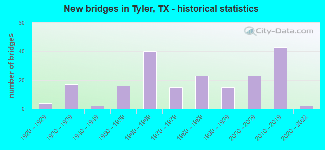
- New bridges - historical statistics
- 41920-1929
- 171930-1939
- 21940-1949
- 161950-1959
- 401960-1969
- 151970-1979
- 231980-1989
- 151990-1999
- 232000-2009
- 432010-2019
- 22020-2022
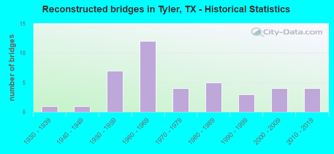
- Reconstructed bridges - Historical Statistics
- 11930-1939
- 11940-1949
- 71950-1959
- 121960-1969
- 41970-1979
- 51980-1989
- 31990-1999
- 42000-2009
- 42010-2019
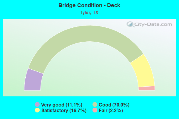
- Bridge Condition - Deck
- 11.1%Very good
- 70.0%Good
- 16.7%Satisfactory
- 2.2%Fair
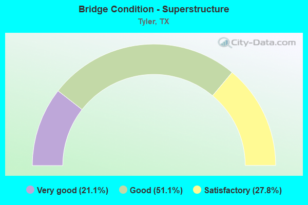
- Bridge Condition - Superstructure
- 21.1%Very good
- 51.1%Good
- 27.8%Satisfactory
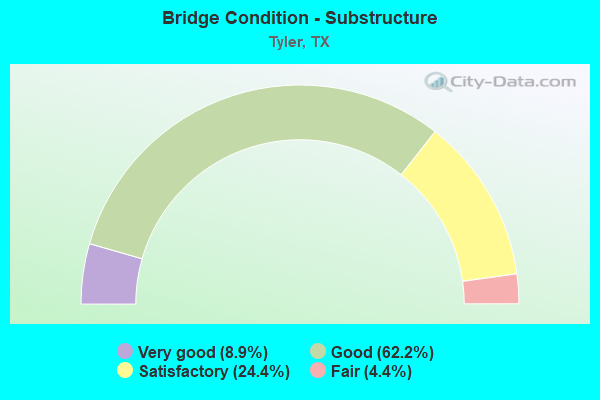
- Bridge Condition - Substructure
- 8.9%Very good
- 62.2%Good
- 24.4%Satisfactory
- 4.4%Fair
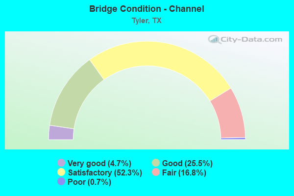
- Bridge Condition - Channel
- 4.7%Very good
- 25.5%Good
- 52.3%Satisfactory
- 16.8%Fair
- 0.7%Poor
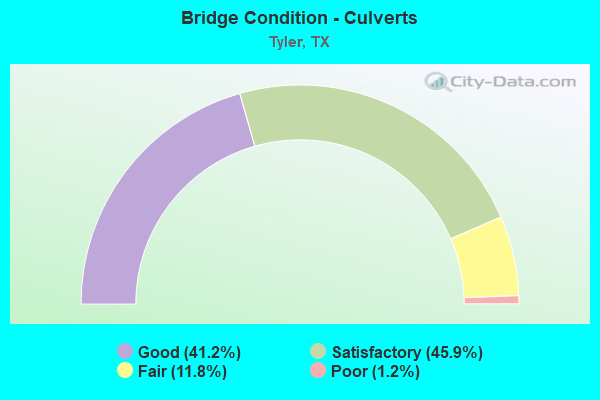
- Bridge Condition - Culverts
- 41.2%Good
- 45.9%Satisfactory
- 11.8%Fair
- 1.2%Poor
Find on map >> Show street view
Structure Number: 102120B03255001, Location: 0.45 MI NW OF LP 323 (Lat: 32.305453, Lng: -95.294358), Route carried "on" structure: City street , Year Built: 1978, Status: Open, Structure Length: 0.76m (2.49ft), Average Daily Traffic: 1,170 (year 2015), Average Future Daily Traffic: 6,000 (year 2035), Features Intersected: W MUD CR TR, Facility Carried by Structure: COPELAND RD
Minimum Vertical Clearance: 30+ m (98+ ft), Kilometerpoint: 2.221, Lanes on structure: 2, Owner: City or Municipal Highway Agency, Approaching Roadway Width: 7.3m (24.0ft), Material/Design: Concrete, Design/Construction: Culvert, Number Of Spans In Main Unit: 3, Length of Maximum Span: 2.4m (7.9ft)
Condition: Channel: Satisfactory, Culverts: Good, Operating Rating: 32.7 metric tons, Method Used To Determine Operating Rating: Field evaluation and documented engineering judgment, Inventory Rating: 24.5 metric tons, Method Used To Determine Inventory Rating: Field evaluation and documented engineering judgment, Structural Evaluation: Equal to present minimum criteria, Waterway Adequacy: Better than present minimum criteria, Approach Roadway Alignment: Equal to present minimum criteria, Designated Inspection Frequency: Every 24 months, Inspection Date: September 2021
Find on map >> Show street view
Structure Number: 102120B03255002, Location: 0.15 MI S OF LP 323 (Lat: 32.301017, Lng: -95.289997), Route carried "on" structure: City street , Year Built: 2005, Status: Open, Structure Length: 1.62m (5.31ft), Average Daily Traffic: 8,450 (year 2015), Average Future Daily Traffic: 10,000 (year 2035), Design Load: HS 20, Features Intersected: W. MUD CREEK, Facility Carried by Structure: NEW COPELAND RD
Minimum Vertical Clearance: 30+ m (98+ ft), Kilometerpoint: 3.573, Lanes on structure: 5, Owner: City or Municipal Highway Agency, Approaching Roadway Width: 17.7m (58.1ft), Skew: 1 degrees, Material/Design: Concrete, Design/Construction: Culvert, Number Of Spans In Main Unit: 5, Length of Maximum Span: 3.0m (9.8ft), Curb or Sidewalk Widths: Left: 2.4m (7.9ft), Right: 1.5m (4.9ft), Curb-To-Curb Width: 17.7m (58.1ft), Out-to-Out Width: 27.9m (91.5ft)
Condition: Channel: Satisfactory, Culverts: Good, Operating Rating: 54.4 metric tons, Method Used To Determine Operating Rating: Assigned rating based on Load Factor Design (LFD) reported in metric tons, Inventory Rating: 32.7 metric tons, Method Used To Determine Inventory Rating: Assigned rating based on Load Factor Design (LFD) reported in metric tons, Structural Evaluation: Better than present minimum criteria, Deck Geometry: High priority of replacement, Waterway Adequacy: Better than present minimum criteria, Approach Roadway Alignment: Equal to present desirable criteria, Designated Inspection Frequency: Every 24 months, Inspection Date: September 2021, Deck Structure Type: Concrete Cast-file-Place, Wearing Surface/Protective System: Wearing Surface: Bituminous
Find on map >> Show street view
Structure Number: 102120B03255003, Location: 1.00 MI S OF LP 323 (Lat: 32.291194, Lng: -95.289761), Route carried "on" structure: City street , Year Built: 1984, Status: Open, Structure Length: 0.91m (2.99ft), Average Daily Traffic: 9,880 (year 2015), Average Future Daily Traffic: 8,000 (year 2035), Features Intersected: W MUD CR TR, Facility Carried by Structure: NEW COPELAND RD
Minimum Vertical Clearance: 6.30m (20.67ft), Kilometerpoint: 4.603, Lanes on structure: 4, Owner: City or Municipal Highway Agency, Approaching Roadway Width: 15.9m (52.2ft), Material/Design: Concrete, Design/Construction: Culvert, Number Of Spans In Main Unit: 3, Length of Maximum Span: 2.7m (8.9ft), Curb or Sidewalk Widths: Left: 3.0m (9.8ft), Right: 3.0m (9.8ft), Curb-To-Curb Width: 15.9m (52.2ft), Out-to-Out Width: 22.3m (73.2ft)
Condition: Channel: Satisfactory, Culverts: Satisfactory, Operating Rating: 32.7 metric tons, Method Used To Determine Operating Rating: Field evaluation and documented engineering judgment, Inventory Rating: 24.5 metric tons, Method Used To Determine Inventory Rating: Field evaluation and documented engineering judgment, Structural Evaluation: Equal to present minimum criteria, Deck Geometry: Meets minimum limits, Waterway Adequacy: Better than present minimum criteria, Approach Roadway Alignment: Equal to present desirable criteria, Length Of Structure Improvement: 0.88m (2.89ft), Designated Inspection Frequency: Every 24 months, Inspection Date: September 2021, Bridge Improvement Cost: $90,000, Roadway Improvement Cost: $78,000, Total Project Cost: $168,000, Deck Structure Type: Concrete Cast-file-Place
Find on map >> Show street view
Structure Number: 102120B03530001, Location: 0.05 MI N OF SH 64 (Lat: 32.351900, Lng: -95.328019), Route carried "on" structure: City street , Year Built: 1975, Status: Posted for load, Structure Length: 1.98m (6.50ft), Average Daily Traffic: 5,199 (year 2018), Average Future Daily Traffic: 6,000 (year 2035), Features Intersected: WILLOW CREEK, Facility Carried by Structure: PARKDALE DR
Minimum Vertical Clearance: 30+ m (98+ ft), Kilometerpoint: 0.209, Lanes on structure: 2, Owner: City or Municipal Highway Agency, Approaching Roadway Width: 15.9m (52.2ft), Skew: 6 degrees, Material/Design: Concrete, Design/Construction: Culvert, Number Of Spans In Main Unit: 3, Length of Maximum Span: 3.0m (9.8ft), Curb-To-Curb Width: 15.9m (52.2ft), Out-to-Out Width: 21.3m (69.9ft)
Condition: Channel: Poor, Culverts: Fair, Operating Rating: 32.7 metric tons, Method Used To Determine Operating Rating: Field evaluation and documented engineering judgment, Inventory Rating: 24.5 metric tons, Method Used To Determine Inventory Rating: Field evaluation and documented engineering judgment, Structural Evaluation: Somewhat better than minimum adequacy, Deck Geometry: Superior to present desirable criteria, Waterway Adequacy: Meets minimum limits, Approach Roadway Alignment: Equal to present desirable criteria, Bridge Posting: Required (Relationship of Operating Rating to Maximum Legal Load: 20.0 - 29.9% below), Designated Inspection Frequency: Every 24 months, Inspection Date: September 2021, Deck Structure Type: Concrete Cast-file-Place, Wearing Surface/Protective System: Wearing Surface: Bituminous
Find on map >> Show street view
Structure Number: 102120B03560001, Location: 0.15 Mi N of SH 248 (Lat: 32.313567, Lng: -95.259531), Route carried "on" structure: City street , Year Built: 1975, Status: Open, Structure Length: 0.82m (2.69ft), Average Daily Traffic: 1,440 (year 2015), Average Future Daily Traffic: 4,000 (year 2035), Features Intersected: Gilley Creek Tributary, Facility Carried by Structure: Patriot Ave
Minimum Vertical Clearance: 30+ m (98+ ft), Kilometerpoint: 0.644, Lanes on structure: 2, Owner: City or Municipal Highway Agency, Approaching Roadway Width: 9.8m (32.2ft), Skew: 5 degrees, Material/Design: Concrete, Design/Construction: Culvert, Number Of Spans In Main Unit: 2, Length of Maximum Span: 3.7m (12.1ft)
Condition: Channel: Fair, Culverts: Satisfactory, Operating Rating: 32.7 metric tons, Method Used To Determine Operating Rating: Field evaluation and documented engineering judgment, Inventory Rating: 24.5 metric tons, Method Used To Determine Inventory Rating: Field evaluation and documented engineering judgment, Structural Evaluation: Equal to present minimum criteria, Waterway Adequacy: Better than present minimum criteria, Approach Roadway Alignment: Equal to present desirable criteria, Designated Inspection Frequency: Every 24 months, Inspection Date: September 2021
Find on map >> Show street view
Structure Number: 102120B03645001, Location: 0.05 MI S OF SH 64 (Lat: 32.331756, Lng: -95.263058), Route carried "on" structure: City street , Year Built: 1984, Status: Open, Structure Length: 0.61m (2.00ft), Average Daily Traffic: 580 (year 2015), Average Future Daily Traffic: 750 (year 2035), Features Intersected: BLACK FORK CR TR, Facility Carried by Structure: PINECREST DR
Minimum Vertical Clearance: 30+ m (98+ ft), Kilometerpoint: 0.113, Lanes on structure: 2, Owner: City or Municipal Highway Agency, Approaching Roadway Width: 10.7m (35.1ft), Material/Design: Concrete, Design/Construction: Culvert, Number Of Spans In Main Unit: 2, Length of Maximum Span: 2.7m (8.9ft)
Condition: Channel: Fair, Culverts: Satisfactory, Operating Rating: 32.7 metric tons, Method Used To Determine Operating Rating: Field evaluation and documented engineering judgment, Inventory Rating: 24.5 metric tons, Method Used To Determine Inventory Rating: Field evaluation and documented engineering judgment, Structural Evaluation: Equal to present minimum criteria, Waterway Adequacy: Better than present minimum criteria, Approach Roadway Alignment: Equal to present desirable criteria, Designated Inspection Frequency: Every 24 months, Inspection Date: September 2021
Find on map >> Show street view
Structure Number: 102120B03855001, Location: 0.70 MI W OF US 69 (Lat: 32.294394, Lng: -95.316281), Route carried "on" structure: City street , Year Built: 1984, Year Reconstructed: 2000, Status: Open, Structure Length: 1.31m (4.30ft), Average Daily Traffic: 8,710 (year 2015), Average Future Daily Traffic: 7,000 (year 2035), Features Intersected: West Mud Creek Tributary, Facility Carried by Structure: RICE RD
Minimum Vertical Clearance: 30+ m (98+ ft), Kilometerpoint: 1.127, Lanes on structure: 4, Owner: City or Municipal Highway Agency, Approaching Roadway Width: 17.7m (58.1ft), Material/Design: Concrete, Design/Construction: Culvert, Number Of Spans In Main Unit: 4, Length of Maximum Span: 3.0m (9.8ft), Curb-To-Curb Width: 17.7m (58.1ft), Out-to-Out Width: 23.6m (77.4ft)
Condition: Channel: Fair, Culverts: Good, Operating Rating: 32.7 metric tons, Method Used To Determine Operating Rating: Field evaluation and documented engineering judgment, Inventory Rating: 24.5 metric tons, Method Used To Determine Inventory Rating: Field evaluation and documented engineering judgment, Structural Evaluation: Equal to present minimum criteria, Deck Geometry: Somewhat better than minimum adequacy, Waterway Adequacy: Better than present minimum criteria, Approach Roadway Alignment: Equal to present desirable criteria, Designated Inspection Frequency: Every 24 months, Inspection Date: September 2021, Deck Structure Type: Concrete Cast-file-Place, Wearing Surface/Protective System: Wearing Surface: Bituminous
Find on map >> Show street view
Structure Number: 102120B03855002, Location: 0.60 MI W OF US 69 (Lat: 32.294683, Lng: -95.314442), Route carried "on" structure: City street , Year Built: 1984, Status: Open, Structure Length: 0.79m (2.59ft), Average Daily Traffic: 8,710 (year 2015), Average Future Daily Traffic: 7,000 (year 2035), Features Intersected: West Mud Creek Tributary, Facility Carried by Structure: Rice RD
Minimum Vertical Clearance: 30+ m (98+ ft), Kilometerpoint: 1.609, Lanes on structure: 4, Owner: City or Municipal Highway Agency, Approaching Roadway Width: 15.9m (52.2ft), Material/Design: Concrete, Design/Construction: Culvert, Number Of Spans In Main Unit: 3, Length of Maximum Span: 2.4m (7.9ft), Curb-To-Curb Width: 15.9m (52.2ft), Out-to-Out Width: 20.2m (66.3ft)
Condition: Channel: Satisfactory, Culverts: Good, Operating Rating: 32.7 metric tons, Method Used To Determine Operating Rating: Field evaluation and documented engineering judgment, Inventory Rating: 24.5 metric tons, Method Used To Determine Inventory Rating: Field evaluation and documented engineering judgment, Structural Evaluation: Equal to present minimum criteria, Deck Geometry: Meets minimum limits, Waterway Adequacy: Better than present minimum criteria, Approach Roadway Alignment: Equal to present desirable criteria, Designated Inspection Frequency: Every 24 months, Inspection Date: September 2021, Deck Structure Type: Concrete Cast-file-Place, Wearing Surface/Protective System: Wearing Surface: Bituminous
Find on map >> Show street view
Structure Number: 102120B03910001, Location: 0.75 MI W OF US 69 (Lat: 32.288089, Lng: -95.315617), Route carried "on" structure: City street , Year Built: 1985, Status: Open, Structure Length: 1.19m (3.90ft), Average Daily Traffic: 3,440 (year 2015), Average Future Daily Traffic: 3,000 (year 2035), Features Intersected: W Mud CR TR, Facility Carried by Structure: Rieck RD
Minimum Vertical Clearance: 30+ m (98+ ft), Kilometerpoint: 0.161, Lanes on structure: 2, Owner: City or Municipal Highway Agency, Approaching Roadway Width: 12.8m (42.0ft), Material/Design: Concrete, Design/Construction: Culvert, Number Of Spans In Main Unit: 4, Length of Maximum Span: 2.7m (8.9ft), Curb-To-Curb Width: 13.5m (44.3ft), Out-to-Out Width: 20.7m (67.9ft)
Condition: Channel: Satisfactory, Culverts: Good, Operating Rating: 32.7 metric tons, Method Used To Determine Operating Rating: Field evaluation and documented engineering judgment, Inventory Rating: 24.5 metric tons, Method Used To Determine Inventory Rating: Field evaluation and documented engineering judgment, Structural Evaluation: Equal to present minimum criteria, Deck Geometry: Superior to present desirable criteria, Waterway Adequacy: Better than present minimum criteria, Approach Roadway Alignment: Equal to present desirable criteria, Designated Inspection Frequency: Every 24 months, Inspection Date: September 2021, Deck Structure Type: Concrete Cast-file-Place, Wearing Surface/Protective System: Wearing Surface: Bituminous
Find on map >> Show street view
Structure Number: 102120B03910002, Location: 0.06 Mi E of US 69 (Lat: 32.289369, Lng: -95.302114), Route carried "on" structure: City street , Year Built: 1984, Year Reconstructed: 2004, Status: Open, Structure Length: 1.13m (3.71ft), Average Daily Traffic: 11,930 (year 2015), Average Future Daily Traffic: 8,000 (year 2035), Features Intersected: West Mud Creek Tributary, Facility Carried by Structure: Rieck RD
Minimum Vertical Clearance: 30+ m (98+ ft), Kilometerpoint: 1.690, Lanes on structure: 2, Owner: City or Municipal Highway Agency, Approaching Roadway Width: 12.2m (40.0ft), Material/Design: Concrete, Design/Construction: Culvert, Number Of Spans In Main Unit: 4, Length of Maximum Span: 3.0m (9.8ft), Curb or Sidewalk Widths: Left: 1.4m (4.6ft), Right: 1.3m (4.3ft), Curb-To-Curb Width: 12.2m (40.0ft), Out-to-Out Width: 18.2m (59.7ft)
Condition: Channel: Good, Culverts: Satisfactory, Operating Rating: 32.7 metric tons, Method Used To Determine Operating Rating: Field evaluation and documented engineering judgment, Inventory Rating: 24.5 metric tons, Method Used To Determine Inventory Rating: Field evaluation and documented engineering judgment, Structural Evaluation: Equal to present minimum criteria, Deck Geometry: Somewhat better than minimum adequacy, Waterway Adequacy: Better than present minimum criteria, Approach Roadway Alignment: Equal to present desirable criteria, Designated Inspection Frequency: Every 24 months, Inspection Date: September 2021, Deck Structure Type: Concrete Cast-file-Place, Wearing Surface/Protective System: Wearing Surface: Bituminous
Find on map >> Show street view
Structure Number: 102120B03910003, Location: 0.35 MI E OF US 69 (Lat: 32.288381, Lng: -95.298103), Route carried "on" structure: City street , Year Built: 1986, Status: Open, Structure Length: 3.08m (10.10ft), Average Daily Traffic: 9,552 (year 2018), Average Future Daily Traffic: 6,700 (year 2035), Features Intersected: W MUD CREEK, Facility Carried by Structure: RIECK RD
Minimum Vertical Clearance: 30+ m (98+ ft), Kilometerpoint: 2.092, Lanes on structure: 2, Owner: City or Municipal Highway Agency, Approaching Roadway Width: 12.2m (40.0ft), Material/Design: Concrete, Design/Construction: Stringer/Multi-beam, Number Of Spans In Main Unit: 1, Number Of Approach Spans: 2, Length of Maximum Span: 12.2m (40.0ft), Curb or Sidewalk Widths: Left: 1.4m (4.6ft), Right: 1.4m (4.6ft), Curb-To-Curb Width: 12.2m (40.0ft), Out-to-Out Width: 15.3m (50.2ft)
Condition: Deck: Good, Superstructure: Good, Substructure: Good, Channel: Satisfactory, Operating Rating: 32.7 metric tons, Method Used To Determine Operating Rating: Field evaluation and documented engineering judgment, Inventory Rating: 24.5 metric tons, Method Used To Determine Inventory Rating: Field evaluation and documented engineering judgment, Structural Evaluation: Equal to present minimum criteria, Deck Geometry: Somewhat better than minimum adequacy, Waterway Adequacy: Better than present minimum criteria, Approach Roadway Alignment: Equal to present desirable criteria, Designated Inspection Frequency: Every 24 months, Inspection Date: September 2021, Deck Structure Type: Concrete Cast-file-Place
Find on map >> Show street view
Structure Number: 102120B03950101, Location: 0.37mi E of SH 155 (Lat: 32.322889, Lng: -95.310375), Route carried "on" structure: City street , Year Built: 2019, Status: Open, Structure Length: 0.85m (2.79ft), Average Daily Traffic: 390 (year 2015), Truck Traffic: 5%, Average Future Daily Traffic: 1 (year 1900), Design Load: HL 93, Features Intersected: W Mud Cr Tr, Facility Carried by Structure: S Robertson Ave
Minimum Vertical Clearance: 30+ m (98+ ft), Kilometerpoint: 9.083, Lanes on structure: 2, Owner: City or Municipal Highway Agency, Approaching Roadway Width: 9.8m (32.2ft), Material/Design: Concrete, Design/Construction: Culvert, Number Of Spans In Main Unit: 3, Length of Maximum Span: 2.7m (8.9ft), Curb or Sidewalk Widths: Left: 2.4m (7.9ft), Right: 2.3m (7.5ft)
Condition: Channel: Very good, Culverts: Good, Operating Rating: 54.4 metric tons, Method Used To Determine Operating Rating: Assigned ratings based on Load and Resistance Factor Design (LRFD) reported in metric tons, Inventory Rating: 32.7 metric tons, Method Used To Determine Inventory Rating: Assigned ratings based on Load and Resistance Factor Design (LRFD) reported in metric tons, Structural Evaluation: Better than present minimum criteria, Waterway Adequacy: Better than present minimum criteria, Approach Roadway Alignment: Equal to present desirable criteria, Designated Inspection Frequency: Every 24 months, Inspection Date: September 2021
Find on map >> Show street view
Structure Number: 102120B04280001, Location: 0.30 MI E OF US 69 (Lat: 32.294758, Lng: -95.295681), Route carried "on" structure: City street , Year Built: 1975, Year Reconstructed: 1989, Status: Open, Structure Length: 2.77m (9.09ft), Average Daily Traffic: 12,396 (year 2018), Average Future Daily Traffic: 15,000 (year 2035), Features Intersected: W MUD CREEK, Facility Carried by Structure: SHILOH RD
Minimum Vertical Clearance: 30+ m (98+ ft), Kilometerpoint: 0.483, Lanes on structure: 5, Owner: City or Municipal Highway Agency, Approaching Roadway Width: 19.5m (64.0ft), Material/Design: Concrete, Design/Construction: Stringer/Multi-beam, Number Of Spans In Main Unit: 3, Length of Maximum Span: 9.1m (29.9ft), Curb or Sidewalk Widths: Left: 1.6m (5.2ft), Right: 1.6m (5.2ft), Curb-To-Curb Width: 19.5m (64.0ft), Out-to-Out Width: 23.2m (76.1ft)
Condition: Deck: Satisfactory, Superstructure: Satisfactory, Substructure: Good, Channel: Satisfactory, Operating Rating: 32.7 metric tons, Method Used To Determine Operating Rating: Field evaluation and documented engineering judgment, Inventory Rating: 24.5 metric tons, Method Used To Determine Inventory Rating: Field evaluation and documented engineering judgment, Structural Evaluation: Equal to present minimum criteria, Deck Geometry: Meets minimum limits, Waterway Adequacy: Better than present minimum criteria, Approach Roadway Alignment: Equal to present desirable criteria, Designated Inspection Frequency: Every 24 months, Inspection Date: September 2021, Deck Structure Type: Concrete Cast-file-Place, Wearing Surface/Protective System: Wearing Surface: Bituminous
Find on map >> Show street view
Structure Number: 102120B04465002, Location: 0.15 Mi SE of FM 2493 (Lat: 32.319422, Lng: -95.307111), Route carried "on" structure: City street , Year Built: 1963, Status: Open, Structure Length: 1.74m (5.71ft), Average Daily Traffic: 5,830 (year 2015), Average Future Daily Traffic: 16,000 (year 2035), Features Intersected: West Mud Creek Tributary, Facility Carried by Structure: SB Sunnybrook Dr
Minimum Vertical Clearance: 6.30m (20.67ft), Kilometerpoint: 1.207, Lanes on structure: 2, Owner: City or Municipal Highway Agency, Approaching Roadway Width: 9.8m (32.2ft), Skew: 6 degrees, Material/Design: Concrete, Design/Construction: Culvert, Number Of Spans In Main Unit: 3, Length of Maximum Span: 2.7m (8.9ft), Curb-To-Curb Width: 9.8m (32.2ft), Out-to-Out Width: 15.2m (49.9ft)
Condition: Channel: Satisfactory, Culverts: Satisfactory, Operating Rating: 32.7 metric tons, Method Used To Determine Operating Rating: Field evaluation and documented engineering judgment, Inventory Rating: 24.5 metric tons, Method Used To Determine Inventory Rating: Field evaluation and documented engineering judgment, Structural Evaluation: Equal to present minimum criteria, Deck Geometry: Meets minimum limits, Waterway Adequacy: Better than present minimum criteria, Approach Roadway Alignment: Equal to present desirable criteria, Length Of Structure Improvement: 1.74m (5.71ft), Designated Inspection Frequency: Every 24 months, Inspection Date: September 2021, Bridge Improvement Cost: $62,000, Roadway Improvement Cost: $48,000, Total Project Cost: $110,000, Deck Structure Type: Concrete Cast-file-Place, Wearing Surface/Protective System: Wearing Surface: Bituminous
Find on map >> Show street view
Structure Number: 102120B04820001, Location: 0.20 MI N OF E DODGE (Lat: 32.340836, Lng: -95.294764), Route carried "on" structure: City street , Year Built: 1962, Status: Open, Structure Length: 0.79m (2.59ft), Average Daily Traffic: 340 (year 2015), Average Future Daily Traffic: 400 (year 2035), Features Intersected: DOUGLAS BRANCH TRIB, Facility Carried by Structure: TURTLE CREEK DR
Minimum Vertical Clearance: 30+ m (98+ ft), Kilometerpoint: 0.040, Lanes on structure: 2, Owner: City or Municipal Highway Agency, Approaching Roadway Width: 8.5m (27.9ft), Skew: 4 degrees, Material/Design: Concrete, Design/Construction: Culvert, Number Of Spans In Main Unit: 2, Length of Maximum Span: 3.4m (11.2ft), Curb or Sidewalk Widths: Left: 1.4m (4.6ft), Right: 1.4m (4.6ft), Curb-To-Curb Width: 12.1m (39.7ft), Out-to-Out Width: 14.9m (48.9ft)
Condition: Channel: Fair, Culverts: Satisfactory, Operating Rating: 32.7 metric tons, Method Used To Determine Operating Rating: Field evaluation and documented engineering judgment, Inventory Rating: 24.5 metric tons, Method Used To Determine Inventory Rating: Field evaluation and documented engineering judgment, Structural Evaluation: Equal to present minimum criteria, Deck Geometry: Superior to present desirable criteria, Waterway Adequacy: Better than present minimum criteria, Approach Roadway Alignment: Equal to present desirable criteria, Designated Inspection Frequency: Every 24 months, Inspection Date: September 2021, Deck Structure Type: Concrete Cast-file-Place, Wearing Surface/Protective System: Wearing Surface: Bituminous
Find on map >> Show street view
Structure Number: 102120B05065001, Location: 0.35 MI SE OF FM 2493 (Lat: 32.315450, Lng: -95.306044), Route carried "on" structure: City street , Year Built: 1954, Status: Posted for load, Structure Length: 0.88m (2.89ft), Average Daily Traffic: 130 (year 2015), Average Future Daily Traffic: 300 (year 2035), Features Intersected: West Mud Creek Tributary, Facility Carried by Structure: Whittle ST
Minimum Vertical Clearance: 30+ m (98+ ft), Kilometerpoint: 0.274, Lanes on structure: 2, Owner: City or Municipal Highway Agency, Approaching Roadway Width: 9.8m (32.2ft), Material/Design: Concrete, Design/Construction: Culvert, Number Of Spans In Main Unit: 3, Length of Maximum Span: 2.7m (8.9ft), Curb-To-Curb Width: 9.8m (32.2ft), Out-to-Out Width: 10.1m (33.1ft)
Condition: Channel: Fair, Culverts: Poor, Operating Rating: 32.7 metric tons, Method Used To Determine Operating Rating: Field evaluation and documented engineering judgment, Inventory Rating: 24.5 metric tons, Method Used To Determine Inventory Rating: Field evaluation and documented engineering judgment, Structural Evaluation: Meets minimum limits, Deck Geometry: Better than present minimum criteria, Waterway Adequacy: Better than present minimum criteria, Approach Roadway Alignment: Equal to present desirable criteria, Bridge Posting: Required (Relationship of Operating Rating to Maximum Legal Load: 20.0 - 29.9% below), Length Of Structure Improvement: 0.88m (2.89ft), Designated Inspection Frequency: Every 24 months, Inspection Date: September 2021, Bridge Improvement Cost: $2,000, Roadway Improvement Cost: $1,000, Total Project Cost: $3,000, Deck Structure Type: Concrete Cast-file-Place, Wearing Surface/Protective System: Wearing Surface: Bituminous
Find on map >> Show street view
Structure Number: 102120B05255001, Location: 0.02 MI W OF SUNNYBROOK (Lat: 32.312958, Lng: -95.305264), Route carried "on" structure: City street , Year Built: 1982, Status: Open, Structure Length: 0.88m (2.89ft), Average Daily Traffic: 350 (year 2015), Average Future Daily Traffic: 400 (year 2035), Features Intersected: West Mud Creek Tributary, Facility Carried by Structure: Buckingham PL
Minimum Vertical Clearance: 6.30m (20.67ft), Kilometerpoint: 0.161, Lanes on structure: 2, Owner: City or Municipal Highway Agency, Approaching Roadway Width: 13.4m (44.0ft), Material/Design: Concrete, Design/Construction: Culvert, Number Of Spans In Main Unit: 3, Length of Maximum Span: 2.7m (8.9ft), Curb-To-Curb Width: 13.5m (44.3ft), Out-to-Out Width: 15.2m (49.9ft)
Condition: Channel: Satisfactory, Culverts: Good, Operating Rating: 32.7 metric tons, Method Used To Determine Operating Rating: Field evaluation and documented engineering judgment, Inventory Rating: 24.5 metric tons, Method Used To Determine Inventory Rating: Field evaluation and documented engineering judgment, Structural Evaluation: Equal to present minimum criteria, Deck Geometry: Superior to present desirable criteria, Waterway Adequacy: Better than present minimum criteria, Approach Roadway Alignment: Equal to present desirable criteria, Length Of Structure Improvement: 0.88m (2.89ft), Designated Inspection Frequency: Every 24 months, Inspection Date: September 2021, Bridge Improvement Cost: $62,000, Roadway Improvement Cost: $69,000, Total Project Cost: $131,000, Deck Structure Type: Concrete Cast-file-Place, Wearing Surface/Protective System: Wearing Surface: Bituminous
Find on map >> Show street view
Structure Number: 102120B05260001, Location: 0.25 MI S OF Grande BLVD (Lat: 32.276789, Lng: -95.317928), Route carried "on" structure: City street , Year Built: 1980, Status: Open, Structure Length: 0.64m (2.10ft), Average Daily Traffic: 2,400 (year 2015), Average Future Daily Traffic: 1,500 (year 2035), Features Intersected: West Mud Creek Tributary, Facility Carried by Structure: Hollytree Drive
Minimum Vertical Clearance: 30+ m (98+ ft), Kilometerpoint: 0.805, Lanes on structure: 2, Owner: City or Municipal Highway Agency, Approaching Roadway Width: 12.2m (40.0ft), Skew: 3 degrees, Material/Design: Concrete, Design/Construction: Culvert, Number Of Spans In Main Unit: 2, Length of Maximum Span: 3.0m (9.8ft)
Condition: Channel: Satisfactory, Culverts: Satisfactory, Operating Rating: 32.7 metric tons, Method Used To Determine Operating Rating: Field evaluation and documented engineering judgment, Inventory Rating: 24.5 metric tons, Method Used To Determine Inventory Rating: Field evaluation and documented engineering judgment, Structural Evaluation: Equal to present minimum criteria, Waterway Adequacy: Better than present minimum criteria, Approach Roadway Alignment: Equal to present desirable criteria, Designated Inspection Frequency: Every 24 months, Inspection Date: September 2021
Find on map >> Show street view
Structure Number: 102120LX7202001, Location: 0.30 MI SE OF SH 155 (Lat: 32.324333, Lng: -95.311953), Route carried "on" structure: City street , Year Built: 2019, Status: Open, Structure Length: 1.07m (3.51ft), Average Daily Traffic: 390 (year 2015), Truck Traffic: 5%, Average Future Daily Traffic: 400 (year 2035), Design Load: HL 93, Features Intersected: W Mud Cr Tr, Facility Carried by Structure: Camellia St
Minimum Vertical Clearance: 30+ m (98+ ft), Kilometerpoint: 0.274, Lanes on structure: 2, Owner: City or Municipal Highway Agency, Approaching Roadway Width: 9.0m (29.5ft), Skew: 3 degrees, Material/Design: Prestressed concrete, Design/Construction: Slab, Number Of Spans In Main Unit: 1, Length of Maximum Span: 10.7m (35.1ft), Curb or Sidewalk Widths: Left: 1.8m (5.9ft), Right: 0.0m, Curb-To-Curb Width: 7.1m (23.3ft), Out-to-Out Width: 9.8m (32.2ft)
Condition: Deck: Good, Superstructure: Very good, Substructure: Very good, Channel: Good, Operating Rating: 54.4 metric tons, Method Used To Determine Operating Rating: Assigned ratings based on Load and Resistance Factor Design (LRFD) reported in metric tons, Inventory Rating: 32.7 metric tons, Method Used To Determine Inventory Rating: Assigned ratings based on Load and Resistance Factor Design (LRFD) reported in metric tons, Structural Evaluation: Equal to present desirable criteria, Deck Geometry: Meets minimum limits, Waterway Adequacy: Better than present minimum criteria, Approach Roadway Alignment: Equal to present desirable criteria, Designated Inspection Frequency: Every 24 months, Inspection Date: September 2021, Deck Structure Type: Concrete Cast-file-Place
Find on map >> Show street view
Structure Number: 102120LX7872001, Location: 0.20 MI SE of Jct SH 155 (Lat: 32.325197, Lng: -95.312603), Route carried "on" structure: City street , Year Built: 2019, Status: Open, Structure Length: 1.07m (3.51ft), Average Daily Traffic: 440 (year 2015), Truck Traffic: 5%, Average Future Daily Traffic: 400 (year 2035), Design Load: HL 93, Features Intersected: W Mud Cr Tr, Facility Carried by Structure: N Azalea Dr
Minimum Vertical Clearance: 30+ m (98+ ft), Kilometerpoint: 0.161, Lanes on structure: 2, Owner: City or Municipal Highway Agency, Approaching Roadway Width: 9.0m (29.5ft), Skew: 3 degrees, Material/Design: Prestressed concrete, Design/Construction: Slab, Number Of Spans In Main Unit: 1, Length of Maximum Span: 10.7m (35.1ft), Curb or Sidewalk Widths: Left: 1.8m (5.9ft), Right: 0.0m, Curb-To-Curb Width: 6.9m (22.6ft), Out-to-Out Width: 9.8m (32.2ft)
Condition: Deck: Good, Superstructure: Very good, Substructure: Good, Channel: Very good, Operating Rating: 54.4 metric tons, Method Used To Determine Operating Rating: Assigned ratings based on Load and Resistance Factor Design (LRFD) reported in metric tons, Inventory Rating: 32.7 metric tons, Method Used To Determine Inventory Rating: Assigned ratings based on Load and Resistance Factor Design (LRFD) reported in metric tons, Structural Evaluation: Better than present minimum criteria, Deck Geometry: Meets minimum limits, Waterway Adequacy: Better than present minimum criteria, Approach Roadway Alignment: Equal to present desirable criteria, Designated Inspection Frequency: Every 24 months, Inspection Date: September 2021, Deck Structure Type: Concrete Cast-file-Place
Find on map >> Show street view
Structure Number: 102120LX8467101, Location: 0.40 MI S OF SH 31 (Lat: 32.339106, Lng: -95.343522), Route carried "on" structure: City street , Year Built: 2016, Status: Open, Structure Length: 0.67m (2.20ft), Average Daily Traffic: 100 (year 2016), Average Future Daily Traffic: 125 (year 2036), Design Load: HL 93, Features Intersected: INDIAN CR TR, Facility Carried by Structure: WHITESIDE RD
Minimum Vertical Clearance: 30+ m (98+ ft), Kilometerpoint: 0.644, Lanes on structure: 2, Owner: City or Municipal Highway Agency, Approaching Roadway Width: 4.9m (16.1ft), Material/Design: Concrete, Design/Construction: Culvert, Number Of Spans In Main Unit: 2, Length of Maximum Span: 3.0m (9.8ft), Curb-To-Curb Width: 10.1m (33.1ft), Out-to-Out Width: 11.6m (38.1ft)
Condition: Channel: Satisfactory, Culverts: Good, Operating Rating: 54.4 metric tons, Method Used To Determine Operating Rating: Assigned rating based on Load Factor Design (LFD) reported in metric tons, Inventory Rating: 32.7 metric tons, Method Used To Determine Inventory Rating: Assigned rating based on Load Factor Design (LFD) reported in metric tons, Structural Evaluation: Better than present minimum criteria, Deck Geometry: Superior to present desirable criteria, Waterway Adequacy: Better than present minimum criteria, Approach Roadway Alignment: Equal to present desirable criteria, Designated Inspection Frequency: Every 24 months, Inspection Date: September 2021, Deck Structure Type: Concrete Cast-file-Place, Wearing Surface/Protective System: Wearing Surface: Bituminous
Find on map >> Show street view
Structure Number: 102120TL0049022, Location: 0.50 MI SW OF FM 2964 (Lat: 32.255628, Lng: -95.258403), Route carried "on" structure: Other road 49, Year Built: 2011, Status: Open, Structure Length: 12.19m (39.99ft), Average Daily Traffic: 1,000 (year 2013), Truck Traffic: 3%, Average Future Daily Traffic: 2,500 (year 2033), Design Load: HL 93, Features Intersected: HILL CR TR
Minimum Vertical Clearance: 30+ m (98+ ft), Kilometerpoint: 27.053, Lanes on structure: 2, Toll: On toll road, Owner: Local Toll Authority, Approaching Roadway Width: 15.2m (49.9ft), Material/Design: Prestressed concrete, Design/Construction: Stringer/Multi-beam, Number Of Spans In Main Unit: 4, Length of Maximum Span: 30.5m (100.1ft), Curb-To-Curb Width: 15.2m (49.9ft), Out-to-Out Width: 15.9m (52.2ft)
Condition: Deck: Good, Superstructure: Good, Substructure: Good, Channel: Good, Operating Rating: 54.4 metric tons, Method Used To Determine Operating Rating: Assigned ratings based on Load and Resistance Factor Design (LRFD) reported in metric tons, Inventory Rating: 32.7 metric tons, Method Used To Determine Inventory Rating: Assigned ratings based on Load and Resistance Factor Design (LRFD) reported in metric tons, Structural Evaluation: Better than present minimum criteria, Deck Geometry: Superior to present desirable criteria, Waterway Adequacy: Superior to present desirable criteria, Approach Roadway Alignment: Equal to present desirable criteria, Designated Inspection Frequency: Every 24 months, Inspection Date: November 2021, Deck Structure Type: Concrete Cast-file-Place
Find on map >> Show street view
Structure Number: 102120TL0049023, Location: 2.0 MI SW of SH 110 (Lat: 32.249814, Lng: -95.267822), Route carried "on" structure: County highway 2191, Year Built: 2011, Status: Open, Structure Length: 11.89m (39.01ft), Average Daily Traffic: 100 (year 2011), Truck Traffic: 2%, Average Future Daily Traffic: 200 (year 2031), Design Load: HL 93, Features Intersected: TOLL 49
Minimum Vertical Clearance: 30+ m (98+ ft), Kilometerpoint: 160.933, Lanes on structure: 2, Lanes under structure: 4, Owner: Local Toll Authority, Approaching Roadway Width: 8.5m (27.9ft), Skew: 2 degrees, Material/Design: Prestressed concrete, Design/Construction: Stringer/Multi-beam, Number Of Spans In Main Unit: 4, Length of Maximum Span: 36.6m (120.1ft), Curb-To-Curb Width: 8.5m (27.9ft), Out-to-Out Width: 9.1m (29.9ft)
Condition: Deck: Very good, Superstructure: Very good, Substructure: Good, Operating Rating: 54.4 metric tons, Method Used To Determine Operating Rating: Assigned ratings based on Load and Resistance Factor Design (LRFD) reported in metric tons, Inventory Rating: 32.7 metric tons, Method Used To Determine Inventory Rating: Assigned ratings based on Load and Resistance Factor Design (LRFD) reported in metric tons, Structural Evaluation: Better than present minimum criteria, Deck Geometry: Better than present minimum criteria, Underclear: Superior to present desirable criteria, Approach Roadway Alignment: Equal to present desirable criteria, Designated Inspection Frequency: Every 24 months, Inspection Date: November 2021, Deck Structure Type: Concrete Cast-file-Place
Find on map >> Show street view
Structure Number: 102120TL0049024, Location: 0.12 MI W OF FM 756 (Lat: 32.246636, Lng: -95.278106), Route carried "on" structure: Other road 49, Year Built: 2011, Status: Open, Structure Length: 0.76m (2.49ft), Average Daily Traffic: 1,000 (year 2013), Truck Traffic: 3%, Average Future Daily Traffic: 2,500 (year 2033), Design Load: HS 20, Features Intersected: SHACKLEFORD CR TR
Minimum Vertical Clearance: 30+ m (98+ ft), Kilometerpoint: 29.210, Lanes on structure: 3, Toll: On toll road, Owner: Local Toll Authority, Approaching Roadway Width: 13.4m (44.0ft), Skew: 4 degrees, Material/Design: Concrete, Design/Construction: Culvert, Number Of Spans In Main Unit: 3, Length of Maximum Span: 1.5m (4.9ft)
Condition: Channel: Good, Culverts: Good, Operating Rating: 54.4 metric tons, Method Used To Determine Operating Rating: Assigned rating based on Load Factor Design (LFD) reported in metric tons, Inventory Rating: 32.7 metric tons, Method Used To Determine Inventory Rating: Assigned rating based on Load Factor Design (LFD) reported in metric tons, Structural Evaluation: Better than present minimum criteria, Waterway Adequacy: Superior to present desirable criteria, Approach Roadway Alignment: Equal to present desirable criteria, Designated Inspection Frequency: Every 24 months, Inspection Date: November 2021
Find on map >> Show street view
Structure Number: 102120TL0049025, Location: 0.2 MI W OF FM 756 (Lat: 32.245867, Lng: -95.278483), Route carried "on" structure: Ramp Other road 49, Year Built: 2009, Status: Open, Structure Length: 0.70m (2.30ft), Average Daily Traffic: 2,000 (year 2010), Truck Traffic: 8%, Average Future Daily Traffic: 3,320 (year 2030), Design Load: HS 20, Features Intersected: SHACKLEFORD CR TR
Minimum Vertical Clearance: 30+ m (98+ ft), Kilometerpoint: 29.250, Lanes on structure: 1, Owner: Local Toll Authority, Approaching Roadway Width: 6.1m (20.0ft), Skew: 4 degrees, Material/Design: Concrete, Design/Construction: Culvert, Number Of Spans In Main Unit: 3, Length of Maximum Span: 1.5m (4.9ft)
Condition: Channel: Satisfactory, Culverts: Good, Operating Rating: 54.4 metric tons, Method Used To Determine Operating Rating: Assigned ratings based on Load and Resistance Factor Design (LRFD) reported in metric tons, Inventory Rating: 32.7 metric tons, Method Used To Determine Inventory Rating: Assigned ratings based on Load and Resistance Factor Design (LRFD) reported in metric tons, Structural Evaluation: Better than present minimum criteria, Waterway Adequacy: Equal to present minimum criteria, Approach Roadway Alignment: Equal to present desirable criteria, Designated Inspection Frequency: Every 24 months, Inspection Date: November 2021
Find on map >> Show street view
Structure Number: 102120TL0049026, Location: 0.8 MI E OF US 69 (Lat: 32.241844, Lng: -95.294114), Route carried "on" structure: Other road 49, Year Built: 2009, Status: Open, Structure Length: 17.68m (58.01ft), Average Daily Traffic: 600 (year 2013), Truck Traffic: 7%, Average Future Daily Traffic: 990 (year 2033), Design Load: HS 25 or greater, Features Intersected: SHACKLEFORD CR
Minimum Vertical Clearance: 30+ m (98+ ft), Kilometerpoint: 30.784, Lanes on structure: 2, Toll: On toll road, Owner: Local Toll Authority, Approaching Roadway Width: 12.8m (42.0ft), Skew: 1 degrees, Material/Design: Prestressed concrete, Design/Construction: Stringer/Multi-beam, Number Of Spans In Main Unit: 5, Length of Maximum Span: 38.1m (125.0ft), Curb-To-Curb Width: 13.4m (44.0ft), Out-to-Out Width: 14.0m (45.9ft)
Condition: Deck: Good, Superstructure: Very good, Substructure: Good, Channel: Good, Operating Rating: 54.4 metric tons, Method Used To Determine Operating Rating: Assigned rating based on Load Factor Design (LFD) reported in metric tons, Inventory Rating: 40.8 metric tons, Method Used To Determine Inventory Rating: Assigned rating based on Load Factor Design (LFD) reported in metric tons, Structural Evaluation: Better than present minimum criteria, Deck Geometry: Superior to present desirable criteria, Waterway Adequacy: Superior to present desirable criteria, Approach Roadway Alignment: Equal to present desirable criteria, Designated Inspection Frequency: Every 24 months, Inspection Date: November 2021, Deck Structure Type: Concrete Cast-file-Place
Find on map >> Show street view
Structure Number: 102120TL0049027, Location: AT US 69, S OF TYLER (Lat: 32.241717, Lng: -95.308350), Route carried "on" structure: Other road 49, Year Built: 2009, Status: Open, Structure Length: 18.14m (59.51ft), Average Daily Traffic: 600 (year 2013), Truck Traffic: 7%, Average Future Daily Traffic: 990 (year 2033), Design Load: HS 25 or greater, Features Intersected: US 69
Minimum Vertical Clearance: 30+ m (98+ ft), Kilometerpoint: 7.258, Lanes on structure: 2, Lanes under structure: 6, Toll: On toll road, Owner: Local Toll Authority, Approaching Roadway Width: 12.8m (42.0ft), Material/Design: Prestressed concrete, Design/Construction: Stringer/Multi-beam, Number Of Spans In Main Unit: 5, Length of Maximum Span: 38.1m (125.0ft), Curb-To-Curb Width: 13.4m (44.0ft), Out-to-Out Width: 14.0m (45.9ft)
Condition: Deck: Good, Superstructure: Good, Substructure: Good, Operating Rating: 54.4 metric tons, Method Used To Determine Operating Rating: Assigned ratings based on Load and Resistance Factor Design (LRFD) reported in metric tons, Inventory Rating: 40.8 metric tons, Method Used To Determine Inventory Rating: Assigned ratings based on Load and Resistance Factor Design (LRFD) reported in metric tons, Structural Evaluation: Better than present minimum criteria, Deck Geometry: Superior to present desirable criteria, Underclear: Superior to present desirable criteria, Approach Roadway Alignment: Equal to present desirable criteria, Designated Inspection Frequency: Every 24 months, Inspection Date: November 2021, Deck Structure Type: Concrete Cast-file-Place
Find on map >> Show street view
Structure Number: 102120TL0049028, Location: 0.8 MI W OF US 69 (Lat: 32.242272, Lng: -95.322625), Route carried "on" structure: Other road 49, Year Built: 2006, Status: Open, Structure Length: 48.77m (160.01ft), Average Daily Traffic: 600 (year 2013), Truck Traffic: 39%, Average Future Daily Traffic: 990 (year 2033), Design Load: HS 25 or greater, Features Intersected: WEST MUD CR
Minimum Vertical Clearance: 30+ m (98+ ft), Kilometerpoint: 33.474, Lanes on structure: 2, Toll: On toll road, Owner: Local Toll Authority, Approaching Roadway Width: 13.4m (44.0ft), Material/Design: Prestressed concrete, Design/Construction: Stringer/Multi-beam, Number Of Spans In Main Unit: 16, Length of Maximum Span: 30.5m (100.1ft), Curb-To-Curb Width: 13.4m (44.0ft), Out-to-Out Width: 14.0m (45.9ft)
Condition: Deck: Good, Superstructure: Good, Substructure: Good, Channel: Satisfactory, Operating Rating: 54.4 metric tons, Method Used To Determine Operating Rating: Assigned rating based on Load Factor Design (LFD) reported in metric tons, Inventory Rating: 40.8 metric tons, Method Used To Determine Inventory Rating: Assigned rating based on Load Factor Design (LFD) reported in metric tons, Structural Evaluation: Better than present minimum criteria, Deck Geometry: Superior to present desirable criteria, Waterway Adequacy: Superior to present desirable criteria, Approach Roadway Alignment: Equal to present desirable criteria, Designated Inspection Frequency: Every 24 months, Inspection Date: November 2021, Deck Structure Type: Concrete Cast-file-Place
Find on map >> Show street view
Structure Number: 102120TL0049029, Location: 1.4 MI W OF US 69 (Lat: 32.244014, Lng: -95.332011), Route carried "on" structure: County highway 128, Year Built: 2006, Status: Open, Structure Length: 15.61m (51.21ft), Average Daily Traffic: 100 (year 2011), Truck Traffic: 10%, Average Future Daily Traffic: 200 (year 2031), Design Load: HS 25 or greater, Features Intersected: TOLL 49
Minimum Vertical Clearance: 30+ m (98+ ft), Kilometerpoint: 0.000, Lanes on structure: 2, Lanes under structure: 2, Owner: Local Toll Authority, Approaching Roadway Width: 13.4m (44.0ft), Skew: 3 degrees, Material/Design: Prestressed concrete, Design/Construction: Stringer/Multi-beam, Number Of Spans In Main Unit: 4, Number Of Approach Spans: 1, Length of Maximum Span: 35.1m (115.2ft), Curb-To-Curb Width: 13.4m (44.0ft), Out-to-Out Width: 14.0m (45.9ft)
Condition: Deck: Good, Superstructure: Good, Substructure: Good, Operating Rating: 54.4 metric tons, Method Used To Determine Operating Rating: Assigned rating based on Load Factor Design (LFD) reported in metric tons, Inventory Rating: 40.8 metric tons, Method Used To Determine Inventory Rating: Assigned rating based on Load Factor Design (LFD) reported in metric tons, Structural Evaluation: Better than present minimum criteria, Deck Geometry: Superior to present desirable criteria, Underclear: Better than present minimum criteria, Approach Roadway Alignment: Equal to present desirable criteria, Designated Inspection Frequency: Every 24 months, Inspection Date: November 2021, Deck Structure Type: Concrete Cast-file-Place
Find on map >> Show street view
Structure Number: 102120TL004903, Location: 1.5 MI W OF US 69 (Lat: 32.244992, Lng: -95.333481), Route carried "on" structure: Other road 49, Year Built: 2006, Status: Open, Structure Length: 0.67m (2.20ft), Average Daily Traffic: 600 (year 2011), Truck Traffic: 39%, Average Future Daily Traffic: 990 (year 2031), Design Load: HL 93, Features Intersected: HENSHAW CR TR
Minimum Vertical Clearance: 30+ m (98+ ft), Kilometerpoint: 34.606, Lanes on structure: 2, Toll: On toll road, Owner: Local Toll Authority, Approaching Roadway Width: 13.4m (44.0ft), Skew: 9 degrees, Material/Design: Concrete, Design/Construction: Culvert, Number Of Spans In Main Unit: 2, Length of Maximum Span: 2.1m (6.9ft)
Condition: Channel: Satisfactory, Culverts: Good, Operating Rating: 54.4 metric tons, Method Used To Determine Operating Rating: Assigned ratings based on Load and Resistance Factor Design (LRFD) reported in metric tons, Inventory Rating: 32.7 metric tons, Method Used To Determine Inventory Rating: Assigned ratings based on Load and Resistance Factor Design (LRFD) reported in metric tons, Structural Evaluation: Better than present minimum criteria, Waterway Adequacy: Superior to present desirable criteria, Approach Roadway Alignment: Equal to present desirable criteria, Designated Inspection Frequency: Every 24 months, Inspection Date: November 2021
Find on map >> Show street view
Structure Number: 102120TL0049031, Location: 2.3 MI W OF US 69 (Lat: 32.243628, Lng: -95.347256), Route carried "on" structure: Other road 49, Year Built: 2006, Status: Open, Structure Length: 45.29m (148.59ft), Average Daily Traffic: 600 (year 2013), Truck Traffic: 39%, Average Future Daily Traffic: 990 (year 2033), Design Load: HS 25 or greater, Features Intersected: FM2493/CR165/HENSHAW CR
Minimum Vertical Clearance: 30+ m (98+ ft), Kilometerpoint: 35.838, Lanes on structure: 2, Lanes under structure: 7, Toll: On toll road, Owner: Local Toll Authority, Approaching Roadway Width: 13.4m (44.0ft), Material/Design: Prestressed concrete, Design/Construction: Stringer/Multi-beam, Number Of Spans In Main Unit: 15, Length of Maximum Span: 29.9m (98.1ft), Curb-To-Curb Width: 13.4m (44.0ft), Out-to-Out Width: 14.0m (45.9ft)
Condition: Deck: Good, Superstructure: Good, Substructure: Good, Channel: Very good, Operating Rating: 54.4 metric tons, Method Used To Determine Operating Rating: Assigned rating based on Load Factor Design (LFD) reported in metric tons, Inventory Rating: 40.8 metric tons, Method Used To Determine Inventory Rating: Assigned rating based on Load Factor Design (LFD) reported in metric tons, Structural Evaluation: Better than present minimum criteria, Deck Geometry: Superior to present desirable criteria, Underclear: Equal to present minimum criteria, Waterway Adequacy: Superior to present desirable criteria, Approach Roadway Alignment: Equal to present desirable criteria, Designated Inspection Frequency: Every 24 months, Inspection Date: November 2021, Deck Structure Type: Concrete Cast-file-Place
Find on map >> Show street view
Structure Number: 102120TL0049032, Location: 2.4 MI W OF US 69 (Lat: 32.242858, Lng: -95.349219), Route carried "on" structure: ServiceOther road 49, Year Built: 2006, Year Reconstructed: 2018, Status: Open, Structure Length: 1.22m (4.00ft), Average Daily Traffic: 750 (year 2013), Truck Traffic: 3%, Average Future Daily Traffic: 1,050 (year 2033), Design Load: HS 20, Features Intersected: HENSHAW CR
Minimum Vertical Clearance: 30+ m (98+ ft), Kilometerpoint: 36.127, Lanes on structure: 2, Owner: Local Toll Authority, Approaching Roadway Width: 12.2m (40.0ft), Material/Design: Concrete, Design/Construction: Culvert, Number Of Spans In Main Unit: 6, Length of Maximum Span: 1.8m (5.9ft), Curb or Sidewalk Widths: Left: 0.0m, Right: 3.7m (12.1ft)
Condition: Channel: Good, Culverts: Good, Operating Rating: 54.4 metric tons, Method Used To Determine Operating Rating: Assigned ratings based on Load and Resistance Factor Design (LRFD) reported in metric tons, Inventory Rating: 32.7 metric tons, Method Used To Determine Inventory Rating: Assigned ratings based on Load and Resistance Factor Design (LRFD) reported in metric tons, Structural Evaluation: Better than present minimum criteria, Waterway Adequacy: Superior to present desirable criteria, Approach Roadway Alignment: Equal to present desirable criteria, Designated Inspection Frequency: Every 24 months, Inspection Date: November 2021
Find on map >> Show street view
Structure Number: 102120TL0049033, Location: 2.4 MI W OF US 69 (Lat: 32.244058, Lng: -95.349761), Route carried "on" structure: ServiceOther road 49, Year Built: 2006, Status: Open, Structure Length: 1.22m (4.00ft), Average Daily Traffic: 750 (year 2013), Truck Traffic: 3%, Average Future Daily Traffic: 1,050 (year 2033), Design Load: HL 93, Features Intersected: HENSHAW CR
Minimum Vertical Clearance: 30+ m (98+ ft), Kilometerpoint: 36.044, Lanes on structure: 2, Owner: Local Toll Authority, Approaching Roadway Width: 11.0m (36.1ft), Material/Design: Concrete, Design/Construction: Culvert, Number Of Spans In Main Unit: 6, Length of Maximum Span: 1.8m (5.9ft)
Condition: Channel: Satisfactory, Culverts: Good, Operating Rating: 54.4 metric tons, Method Used To Determine Operating Rating: Assigned ratings based on Load and Resistance Factor Design (LRFD) reported in metric tons, Inventory Rating: 32.7 metric tons, Method Used To Determine Inventory Rating: Assigned ratings based on Load and Resistance Factor Design (LRFD) reported in metric tons, Structural Evaluation: Better than present minimum criteria, Waterway Adequacy: Superior to present desirable criteria, Approach Roadway Alignment: Equal to present desirable criteria, Designated Inspection Frequency: Every 24 months, Inspection Date: November 2021
Find on map >> Show street view
Structure Number: 102120TL0049034, Location: 3.2 MI W OF US 69 (Lat: 32.241928, Lng: -95.362856), Route carried "on" structure: County highway 178, Year Built: 2006, Status: Open, Structure Length: 10.00m (32.81ft), Average Daily Traffic: 600 (year 2011), Truck Traffic: 10%, Average Future Daily Traffic: 800 (year 2031), Design Load: HS 25 or greater, Features Intersected: TOLL 49
Minimum Vertical Clearance: 30+ m (98+ ft), Kilometerpoint: 2.696, Lanes on structure: 2, Lanes under structure: 2, Owner: Local Toll Authority, Approaching Roadway Width: 16.8m (55.1ft), Material/Design: Prestressed concrete, Design/Construction: Stringer/Multi-beam, Number Of Spans In Main Unit: 2, Number Of Approach Spans: 2, Length of Maximum Span: 28.7m (94.2ft), Curb-To-Curb Width: 17.7m (58.1ft), Out-to-Out Width: 18.3m (60.0ft)
Condition: Deck: Good, Superstructure: Very good, Substructure: Good, Operating Rating: 54.4 metric tons, Method Used To Determine Operating Rating: Assigned rating based on Load Factor Design (LFD) reported in metric tons, Inventory Rating: 40.8 metric tons, Method Used To Determine Inventory Rating: Assigned rating based on Load Factor Design (LFD) reported in metric tons, Structural Evaluation: Better than present minimum criteria, Deck Geometry: Superior to present desirable criteria, Underclear: Better than present minimum criteria, Approach Roadway Alignment: Equal to present desirable criteria, Designated Inspection Frequency: Every 24 months, Inspection Date: November 2021, Deck Structure Type: Concrete Cast-file-Place
Find on map >> Show street view
Structure Number: 102120TL0049043, Location: 2.6 MI S OF SH 31 (Lat: 32.292792, Lng: -95.412150), Route carried "on" structure: County highway 1227, Year Built: 2012, Status: Open, Structure Length: 10.97m (35.99ft), Average Daily Traffic: 100 (year 2013), Truck Traffic: 1%, Average Future Daily Traffic: 250 (year 2033), Design Load: HL 93, Features Intersected: TOLL 49
Minimum Vertical Clearance: 30+ m (98+ ft), Kilometerpoint: 0.002, Lanes on structure: 2, Lanes under structure: 2, Owner: Local Toll Authority, Approaching Roadway Width: 7.9m (25.9ft), Material/Design: Prestressed concrete, Design/Construction: Stringer/Multi-beam, Number Of Spans In Main Unit: 4, Length of Maximum Span: 30.5m (100.1ft), Curb-To-Curb Width: 8.5m (27.9ft), Out-to-Out Width: 9.1m (29.9ft)
Condition: Deck: Good, Superstructure: Good, Substructure: Good, Operating Rating: 54.4 metric tons, Method Used To Determine Operating Rating: Assigned ratings based on Load and Resistance Factor Design (LRFD) reported in metric tons, Inventory Rating: 32.7 metric tons, Method Used To Determine Inventory Rating: Assigned ratings based on Load and Resistance Factor Design (LRFD) reported in metric tons, Structural Evaluation: Better than present minimum criteria, Deck Geometry: Better than present minimum criteria, Underclear: Better than present minimum criteria, Approach Roadway Alignment: Equal to present desirable criteria, Designated Inspection Frequency: Every 24 months, Inspection Date: November 2021, Deck Structure Type: Concrete Cast-file-Place
Find on map >> Show street view
Structure Number: 102120TL0049044, Location: 2.05 MI S OF SH 31 (Lat: 32.300839, Lng: -95.412581), Route carried "on" structure: Other road 49, Year Built: 2012, Status: Open, Structure Length: 17.53m (57.51ft), Average Daily Traffic: 1,000 (year 2013), Truck Traffic: 5%, Average Future Daily Traffic: 2,500 (year 2033), Design Load: HL 93, Features Intersected: INDIAN CR TR
Minimum Vertical Clearance: 30+ m (98+ ft), Kilometerpoint: 46.642, Lanes on structure: 2, Toll: On toll road, Owner: Local Toll Authority, Approaching Roadway Width: 13.4m (44.0ft), Material/Design: Prestressed concrete, Design/Construction: Stringer/Multi-beam, Number Of Spans In Main Unit: 5, Length of Maximum Span: 35.1m (115.2ft), Curb-To-Curb Width: 13.4m (44.0ft), Out-to-Out Width: 14.0m (45.9ft)
Condition: Deck: Good, Superstructure: Good, Substructure: Very good, Channel: Good, Operating Rating: 54.4 metric tons, Method Used To Determine Operating Rating: Assigned ratings based on Load and Resistance Factor Design (LRFD) reported in metric tons, Inventory Rating: 32.7 metric tons, Method Used To Determine Inventory Rating: Assigned ratings based on Load and Resistance Factor Design (LRFD) reported in metric tons, Structural Evaluation: Better than present minimum criteria, Deck Geometry: Superior to present desirable criteria, Waterway Adequacy: Superior to present desirable criteria, Approach Roadway Alignment: Equal to present desirable criteria, Designated Inspection Frequency: Every 24 months, Inspection Date: November 2021, Deck Structure Type: Concrete Cast-file-Place
Find on map >> Show street view
Structure Number: 102120TL0049045, Location: 1.55 MI S OF SH 31 (Lat: 32.307806, Lng: -95.414792), Route carried "on" structure: Other road 49, Year Built: 2012, Status: Open, Structure Length: 76.20m (250.00ft), Average Daily Traffic: 1,000 (year 2013), Truck Traffic: 5%, Average Future Daily Traffic: 5,000 (year 2033), Design Load: HL 93, Features Intersected: CR 1134/UPRR/INDIAN CR
Minimum Vertical Clearance: 30+ m (98+ ft), Kilometerpoint: 47.443, Lanes on structure: 2, Lanes under structure: 2, Toll: On toll road, Owner: Local Toll Authority, Approaching Roadway Width: 13.4m (44.0ft), Material/Design: Prestressed concrete, Design/Construction: Stringer/Multi-beam, Number Of Spans In Main Unit: 22, Length of Maximum Span: 35.1m (115.2ft), Curb-To-Curb Width: 13.4m (44.0ft), Out-to-Out Width: 14.0m (45.9ft)
Condition: Deck: Good, Superstructure: Good, Substructure: Good, Channel: Satisfactory, Operating Rating: 54.4 metric tons, Method Used To Determine Operating Rating: Assigned ratings based on Load and Resistance Factor Design (LRFD) reported in metric tons, Inventory Rating: 32.7 metric tons, Method Used To Determine Inventory Rating: Assigned ratings based on Load and Resistance Factor Design (LRFD) reported in metric tons, Structural Evaluation: Better than present minimum criteria, Deck Geometry: Superior to present desirable criteria, Underclear: Equal to present desirable criteria, Waterway Adequacy: Superior to present desirable criteria, Approach Roadway Alignment: Equal to present desirable criteria, Designated Inspection Frequency: Every 24 months, Inspection Date: November 2021, Deck Structure Type: Concrete Cast-file-Place
Find on map >> Show street view
Structure Number: 102120TL0049046, Location: 2.55 MI S OF SH 64 (Lat: 32.328461, Lng: -95.418764), Route carried "on" structure: Other road 49, Year Built: 2012, Status: Open, Structure Length: 14.94m (49.02ft), Average Daily Traffic: 1,000 (year 2013), Truck Traffic: 4%, Average Future Daily Traffic: 2,500 (year 2033), Design Load: HL 93, Features Intersected: SH 31
Minimum Vertical Clearance: 30+ m (98+ ft), Kilometerpoint: 49.930, Lanes on structure: 2, Lanes under structure: 6, Toll: On toll road, Owner: Local Toll Authority, Approaching Roadway Width: 13.4m (44.0ft), Material/Design: Prestressed concrete, Design/Construction: Stringer/Multi-beam, Number Of Spans In Main Unit: 5, Length of Maximum Span: 32.0m (105.0ft), Curb-To-Curb Width: 13.4m (44.0ft), Out-to-Out Width: 14.0m (45.9ft)
Condition: Deck: Good, Superstructure: Good, Substructure: Good, Operating Rating: 54.4 metric tons, Method Used To Determine Operating Rating: Assigned ratings based on Load and Resistance Factor Design (LRFD) reported in metric tons, Inventory Rating: 32.7 metric tons, Method Used To Determine Inventory Rating: Assigned ratings based on Load and Resistance Factor Design (LRFD) reported in metric tons, Structural Evaluation: Better than present minimum criteria, Deck Geometry: Superior to present desirable criteria, Underclear: Better than present minimum criteria, Approach Roadway Alignment: Equal to present desirable criteria, Designated Inspection Frequency: Every 24 months, Inspection Date: November 2021, Deck Structure Type: Concrete Cast-file-Place
Find on map >> Show street view
Structure Number: 102120TL0049047, Location: 0.33 MI N OF SH 31 (Lat: 32.335225, Lng: -95.420103), Route carried "on" structure: Other road 49, Year Built: 2013, Status: Open, Structure Length: 0.82m (2.69ft), Average Daily Traffic: 1,000 (year 2013), Truck Traffic: 5%, Average Future Daily Traffic: 2,500 (year 2033), Design Load: HL 93, Features Intersected: INDIAN CR TR
Minimum Vertical Clearance: 30+ m (98+ ft), Kilometerpoint: 50.484, Lanes on structure: 3, Toll: On toll road, Owner: Local Toll Authority, Approaching Roadway Width: 19.2m (63.0ft), Skew: 13 degrees, Material/Design: Concrete, Design/Construction: Culvert, Number Of Spans In Main Unit: 2, Length of Maximum Span: 3.0m (9.8ft)
Condition: Channel: Good, Culverts: Good, Operating Rating: 54.4 metric tons, Method Used To Determine Operating Rating: Assigned ratings based on Load and Resistance Factor Design (LRFD) reported in metric tons, Inventory Rating: 32.7 metric tons, Method Used To Determine Inventory Rating: Assigned ratings based on Load and Resistance Factor Design (LRFD) reported in metric tons, Structural Evaluation: Better than present minimum criteria, Waterway Adequacy: Superior to present desirable criteria, Approach Roadway Alignment: Equal to present desirable criteria, Designated Inspection Frequency: Every 24 months, Inspection Date: November 2021
Find on map >> Show street view
Structure Number: 102120TL0049048, Location: 1.80 MI S OF SH 64 (Lat: 32.340206, Lng: -95.422892), Route carried "on" structure: County highway 1145, Year Built: 2013, Status: Open, Structure Length: 7.50m (24.61ft), Average Daily Traffic: 100 (year 2013), Average Future Daily Traffic: 200 (year 2033), Design Load: HL 93, Features Intersected: TOLL 49
Minimum Vertical Clearance: 30+ m (98+ ft), Kilometerpoint: 0.002, Lanes on structure: 2, Lanes under structure: 2, Owner: Local Toll Authority, Approaching Roadway Width: 8.2m (26.9ft), Skew: 1 degrees, Material/Design: Prestressed concrete, Design/Construction: Stringer/Multi-beam, Number Of Spans In Main Unit: 3, Length of Maximum Span: 29.9m (98.1ft), Curb-To-Curb Width: 8.5m (27.9ft), Out-to-Out Width: 9.1m (29.9ft)
Condition: Deck: Good, Superstructure: Very good, Substructure: Good, Operating Rating: 54.4 metric tons, Method Used To Determine Operating Rating: Assigned ratings based on Load and Resistance Factor Design (LRFD) reported in metric tons, Inventory Rating: 32.7 metric tons, Method Used To Determine Inventory Rating: Assigned ratings based on Load and Resistance Factor Design (LRFD) reported in metric tons, Structural Evaluation: Better than present minimum criteria, Deck Geometry: Better than present minimum criteria, Underclear: Better than present minimum criteria, Approach Roadway Alignment: Equal to present desirable criteria, Designated Inspection Frequency: Every 24 months, Inspection Date: November 2021, Deck Structure Type: Concrete Cast-file-Place
Find on map >> Show street view
Structure Number: 102120TL0049049, Location: 1.35 MI S OF SH 64 (Lat: 32.347203, Lng: -95.424028), Route carried "on" structure: Other road 49, Year Built: 2013, Status: Open, Structure Length: 1.13m (3.71ft), Average Daily Traffic: 1,000 (year 2013), Truck Traffic: 5%, Average Future Daily Traffic: 2,500 (year 2033), Design Load: HL 93, Features Intersected: NECHES RV TR 2
Minimum Vertical Clearance: 30+ m (98+ ft), Kilometerpoint: 51.890, Lanes on structure: 2, Toll: On toll road, Owner: Local Toll Authority, Approaching Roadway Width: 12.2m (40.0ft), Skew: 2 degrees, Material/Design: Concrete, Design/Construction: Culvert, Number Of Spans In Main Unit: 3, Length of Maximum Span: 3.0m (9.8ft)
Condition: Channel: Good, Culverts: Good, Operating Rating: 54.4 metric tons, Method Used To Determine Operating Rating: Assigned ratings based on Load and Resistance Factor Design (LRFD) reported in metric tons, Inventory Rating: 32.7 metric tons, Method Used To Determine Inventory Rating: Assigned ratings based on Load and Resistance Factor Design (LRFD) reported in metric tons, Structural Evaluation: Better than present minimum criteria, Waterway Adequacy: Superior to present desirable criteria, Approach Roadway Alignment: Equal to present desirable criteria, Designated Inspection Frequency: Every 24 months, Inspection Date: November 2021
Find on map >> Show street view
Structure Number: 102120TL004905, Location: 0.85 MI S OF SH 64 (Lat: 32.353847, Lng: -95.426261), Route carried "on" structure: Other road 49, Year Built: 2013, Status: Open, Structure Length: 0.76m (2.49ft), Average Daily Traffic: 1,000 (year 2013), Truck Traffic: 5%, Average Future Daily Traffic: 2,500 (year 2033), Design Load: HL 93, Features Intersected: NECHES RV TR 1
Minimum Vertical Clearance: 30+ m (98+ ft), Kilometerpoint: 52.658, Lanes on structure: 2, Toll: On toll road, Owner: Local Toll Authority, Approaching Roadway Width: 12.2m (40.0ft), Skew: 2 degrees, Material/Design: Concrete, Design/Construction: Culvert, Number Of Spans In Main Unit: 2, Length of Maximum Span: 3.0m (9.8ft)
Condition: Channel: Satisfactory, Culverts: Good, Operating Rating: 54.4 metric tons, Method Used To Determine Operating Rating: Assigned ratings based on Load and Resistance Factor Design (LRFD) reported in metric tons, Inventory Rating: 32.7 metric tons, Method Used To Determine Inventory Rating: Assigned ratings based on Load and Resistance Factor Design (LRFD) reported in metric tons, Structural Evaluation: Better than present minimum criteria, Waterway Adequacy: Superior to present desirable criteria, Approach Roadway Alignment: Equal to present desirable criteria, Designated Inspection Frequency: Every 24 months, Inspection Date: November 2021