Bridge Statistics for Utica, New York (NY)
Condition, Traffic, Stress, Structural Evaluation, Project Costs
- National Bridge Inventory (NBI) Statistics
- 122Number of bridges
- 1,608ft / 490mTotal length
- $239,612,000Total costs
- 1,219,282Total average daily traffic
- 64,574Total average daily truck traffic
- National Bridge Inventory (NBI) Registered Bridges for Utica
- No street view available for this location
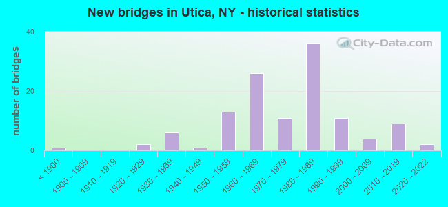
- New bridges - historical statistics
- 1Before 1900
- 21920-1929
- 61930-1939
- 11940-1949
- 131950-1959
- 261960-1969
- 111970-1979
- 361980-1989
- 111990-1999
- 42000-2009
- 92010-2019
- 22020-2022
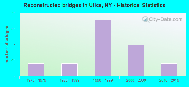
- Reconstructed bridges - Historical Statistics
- 21970-1979
- 21980-1989
- 91990-1999
- 52000-2009
- 22010-2019
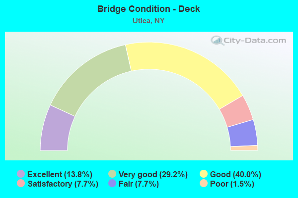
- Bridge Condition - Deck
- 13.8%Excellent
- 29.2%Very good
- 40.0%Good
- 7.7%Satisfactory
- 7.7%Fair
- 1.5%Poor
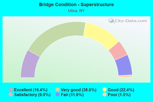
- Bridge Condition - Superstructure
- 16.4%Excellent
- 38.8%Very good
- 22.4%Good
- 9.0%Satisfactory
- 11.9%Fair
- 1.5%Poor
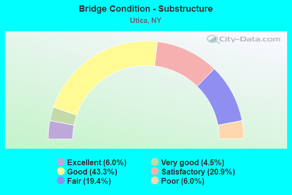
- Bridge Condition - Substructure
- 6.0%Excellent
- 4.5%Very good
- 43.3%Good
- 20.9%Satisfactory
- 19.4%Fair
- 6.0%Poor
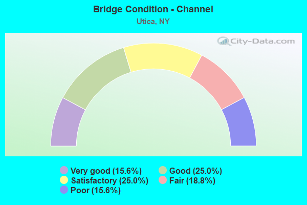
- Bridge Condition - Channel
- 15.6%Very good
- 25.0%Good
- 25.0%Satisfactory
- 18.8%Fair
- 15.6%Poor
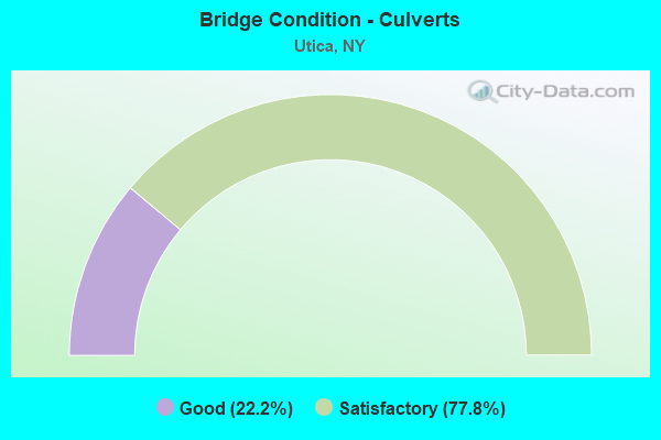
- Bridge Condition - Culverts
- 22.2%Good
- 77.8%Satisfactory
Find on map >> Show street view
Structure Number: 107953, Location: Utica (Lat: 43.103861, Lng: -75.239039), Route carried "on" structure: State highway , Year Built: 2016, Status: Open, Structure Length: 2.44m (8.01ft), Average Daily Traffic: 34,000 (year 0015), Truck Traffic: 7%, Average Future Daily Traffic: 47,600 (year 0035), Design Load: HL 93, Features Intersected: COLUMBIA STREET, Facility Carried by Structure: City street 5 26
Minimum Vertical Clearance: 30+ m (98+ ft), Kilometerpoint: 34.272, Lanes on structure: 5, Lanes under structure: 2, Owner: State Highway Agency, Approaching Roadway Width: 26.8m (87.9ft), Skew: 20 degrees, Material/Design: Steel, Design/Construction: Stringer/Multi-beam, Number Of Spans In Main Unit: 1, Length of Maximum Span: 22.6m (74.1ft), Curb-To-Curb Width: 26.8m (87.9ft), Out-to-Out Width: 28.3m (92.8ft)
Condition: Deck: Excellent, Superstructure: Excellent, Substructure: Excellent, Operating Rating: 75.3 metric tons, Method Used To Determine Operating Rating: Load Factor (LF), Inventory Rating: 44.5 metric tons, Method Used To Determine Inventory Rating: Load Factor (LF), Structural Evaluation: Superior to present desirable criteria, Deck Geometry: Superior to present desirable criteria, Underclear: Superior to present desirable criteria, Approach Roadway Alignment: Equal to present desirable criteria, Length Of Structure Improvement: 2.43m (7.97ft), Designated Inspection Frequency: Every 24 months, Inspection Date: November 2021, Bridge Improvement Cost: $1,844,000, Roadway Improvement Cost: $1,080,000, Total Project Cost: $2,923,000 ( Estimate for 2021), Deck Structure Type: Concrete Cast-file-Place, Wearing Surface/Protective System: Wearing Surface: Monolithic Concrete, Deck Protection: Other Coated Reinforcing
Find on map >> Show street view
Structure Number: 107954, Location: City of Utica (Lat: 43.104772, Lng: -75.238919), Route carried "on" structure: State highway , Year Built: 2017, Status: Open, Structure Length: 2.68m (8.79ft), Average Daily Traffic: 34,000 (year 0015), Truck Traffic: 7%, Average Future Daily Traffic: 47,600 (year 0035), Design Load: HL 93, Features Intersected: LAFAYETTE STREET, Facility Carried by Structure: City street 5 26
Minimum Vertical Clearance: 30+ m (98+ ft), Kilometerpoint: 34.433, Lanes on structure: 6, Lanes under structure: 2, Owner: State Highway Agency, Approaching Roadway Width: 30.5m (100.1ft), Skew: 21 degrees, Material/Design: Steel, Design/Construction: Stringer/Multi-beam, Number Of Spans In Main Unit: 1, Length of Maximum Span: 25.0m (82.0ft), Curb-To-Curb Width: 30.5m (100.1ft), Out-to-Out Width: 32.0m (105.0ft)
Condition: Deck: Excellent, Superstructure: Excellent, Substructure: Excellent, Operating Rating: 66.2 metric tons, Method Used To Determine Operating Rating: Load Factor (LF), Inventory Rating: 39.0 metric tons, Method Used To Determine Inventory Rating: Load Factor (LF), Structural Evaluation: Superior to present desirable criteria, Deck Geometry: Superior to present desirable criteria, Underclear: Superior to present desirable criteria, Approach Roadway Alignment: Equal to present desirable criteria, Length Of Structure Improvement: 2.68m (8.79ft), Designated Inspection Frequency: Every 24 months, Inspection Date: November 2021, Bridge Improvement Cost: $2,108,000, Roadway Improvement Cost: $1,234,000, Total Project Cost: $3,342,000 ( Estimate for 2021), Deck Structure Type: Concrete Cast-file-Place, Wearing Surface/Protective System: Wearing Surface: Monolithic Concrete, Deck Protection: Other Coated Reinforcing
Find on map >> Show street view
Structure Number: 107955, Location: Jct Rts 5A, 5S, 5 Utica (Lat: 43.105897, Lng: -75.238911), Route carried "on" structure: State highway 790, Year Built: 2017, Status: Open, Structure Length: 9.75m (31.99ft), Average Daily Traffic: 20,346 (year 2019), Truck Traffic: 4%, Average Future Daily Traffic: 23,442 (year 2040), Design Load: HL 93, Features Intersected: 5S 5S 26011000 WB, Ramp
Minimum Vertical Clearance: 30+ m (98+ ft), Kilometerpoint: 0.000, Lanes on structure: 6, Lanes under structure: 7, Owner: State Highway Agency, Approaching Roadway Width: 30.5m (100.1ft), Skew: 21 degrees, Material/Design: Steel continuous, Design/Construction: Stringer/Multi-beam, Number Of Spans In Main Unit: 2, Length of Maximum Span: 50.3m (165.0ft), Curb-To-Curb Width: 30.5m (100.1ft), Out-to-Out Width: 32.0m (105.0ft)
Condition: Deck: Excellent, Superstructure: Excellent, Substructure: Very good, Operating Rating: 49.9 metric tons, Method Used To Determine Operating Rating: Load and Resistance Factor Rating (LRFR) rating reported by rating factor(RF) method using HL-93 loadings, Inventory Rating: 38.6 metric tons, Method Used To Determine Inventory Rating: Load and Resistance Factor Rating (LRFR) rating reported by rating factor(RF) method using HL-93 loadings, Structural Evaluation: Equal to present desirable criteria, Deck Geometry: Superior to present desirable criteria, Underclear: High priority of corrective action, Approach Roadway Alignment: Equal to present desirable criteria, Length Of Structure Improvement: 9.75m (31.99ft), Designated Inspection Frequency: Every 24 months, Inspection Date: November 2021, Bridge Improvement Cost: $5,747,000, Roadway Improvement Cost: $3,365,000, Total Project Cost: $9,112,000 ( Estimate for 2021), Deck Structure Type: Concrete Cast-file-Place, Wearing Surface/Protective System: Wearing Surface: Integral Concrete, Deck Protection: Other Coated Reinforcing
Find on map >> Show street view
Structure Number: 108056, Location: 5 5 26036C01_NAIL_CREEK (Lat: 43.091061, Lng: -75.265556), Route carried "on" structure: Ramp State highway , Year Built: 1976, Status: Open, Structure Length: 0.61m (2.00ft), Average Daily Traffic: 4,318 (year 2018), Truck Traffic: 10%, Average Future Daily Traffic: 5,388 (year 2040), Design Load: HS 20, Features Intersected: Nail Creek, Facility Carried by Structure: 5 5 26036C01
Minimum Vertical Clearance: 32.69m (107.25ft), Kilometerpoint: 0.193, Lanes on structure: 1, Owner: State Highway Agency, Approaching Roadway Width: 7.9m (25.9ft), Material/Design: Steel, Design/Construction: Culvert, Number Of Spans In Main Unit: 1, Length of Maximum Span: 6.1m (20.0ft)
Condition: Channel: Satisfactory, Culverts: Good, Operating Rating: 76.9 metric tons, Method Used To Determine Operating Rating: Field evaluation and documented engineering judgment, Inventory Rating: 32.7 metric tons, Method Used To Determine Inventory Rating: Field evaluation and documented engineering judgment, Structural Evaluation: Better than present minimum criteria, Waterway Adequacy: Equal to present minimum criteria, Approach Roadway Alignment: Equal to present desirable criteria, Length Of Structure Improvement: 0.60m (1.97ft), Designated Inspection Frequency: Every 24 months, Inspection Date: November 2020, Bridge Improvement Cost: $94,000, Roadway Improvement Cost: $55,000, Total Project Cost: $149,000 ( Estimate for 2021)
Find on map >> Show street view
Structure Number: 1090509, Location: 02MI N JCT RTS 5S+921C (Lat: 43.105750, Lng: -75.223400), Route carried "on" structure: City street 921C, Year Built: 1973, Status: Open, Structure Length: 38.40m (125.98ft), Average Daily Traffic: 6,799 (year 2008), Truck Traffic: 6%, Average Future Daily Traffic: 6,830 (year 2040), Design Load: HS 20, Features Intersected: MA&N, LEE STREET, John S
Minimum Vertical Clearance: 30+ m (98+ ft), Kilometerpoint: 0.209, Lanes on structure: 3, Lanes under structure: 10, Base Highway Network: Yes, Owner: State Highway Agency, Approaching Roadway Width: 17.7m (58.1ft), Skew: 31 degrees, Material/Design: Steel continuous, Design/Construction: Stringer/Multi-beam, Number Of Spans In Main Unit: 13, Length of Maximum Span: 46.0m (150.9ft), Curb or Sidewalk Widths: Left: 0.0m, Right: 1.5m (4.9ft), Curb-To-Curb Width: 16.2m (53.1ft), Out-to-Out Width: 17.1m (56.1ft)
Condition: Deck: Good, Superstructure: Good, Substructure: Satisfactory, Operating Rating: 76.2 metric tons, Method Used To Determine Operating Rating: Load Factor (LF), Inventory Rating: 45.4 metric tons, Method Used To Determine Inventory Rating: Load Factor (LF), Structural Evaluation: Equal to present minimum criteria, Deck Geometry: Better than present minimum criteria, Underclear: High priority of corrective action, Approach Roadway Alignment: Equal to present desirable criteria, Length Of Structure Improvement: 38.40m (125.98ft), Designated Inspection Frequency: Every 24 months, Inspection Date: December 2020, Bridge Improvement Cost: $9,774,000, Roadway Improvement Cost: $5,724,000, Total Project Cost: $15,498,000 ( Estimate for 2021), Deck Structure Type: Concrete Cast-file-Place, Wearing Surface/Protective System: Wearing Surface: Monolithic Concrete
Find on map >> Show street view
Structure Number: 109050A, Location: .2 MI N JCT SH 5S & 921C (Lat: 43.104572, Lng: -75.224653), Route carried "on" structure: Ramp City street , Year Built: 1973, Year Reconstructed: 2009, Status: Open, Structure Length: 11.55m (37.89ft), Average Daily Traffic: 8,557 (year 2017), Truck Traffic: 6%, Average Future Daily Traffic: 8,597 (year 2040), Design Load: HS 20, Features Intersected: MAIN STREET, RELIEF, WAT, Facility Carried by Structure: NB RAMP TO 921C N
Minimum Vertical Clearance: 30+ m (98+ ft), Kilometerpoint: 0.064, Lanes on structure: 2, Owner: State Highway Agency, Approaching Roadway Width: 8.8m (28.9ft), Material/Design: Steel, Design/Construction: Stringer/Multi-beam, Number Of Spans In Main Unit: 4, Length of Maximum Span: 30.7m (100.7ft), Curb or Sidewalk Widths: Left: 1.5m (4.9ft), Right: 0.0m, Curb-To-Curb Width: 8.8m (28.9ft), Out-to-Out Width: 11.1m (36.4ft)
Condition: Deck: Good, Superstructure: Good, Substructure: Satisfactory, Operating Rating: 77.1 metric tons, Method Used To Determine Operating Rating: Load Factor (LF), Inventory Rating: 46.3 metric tons, Method Used To Determine Inventory Rating: Load Factor (LF), Structural Evaluation: Equal to present minimum criteria, Deck Geometry: Meets minimum limits, Approach Roadway Alignment: Equal to present desirable criteria, Length Of Structure Improvement: 11.55m (37.89ft), Designated Inspection Frequency: Every 24 months, Inspection Date: September 2021, Bridge Improvement Cost: $1,996,000, Roadway Improvement Cost: $1,169,000, Total Project Cost: $3,165,000 ( Estimate for 2021), Deck Structure Type: Concrete Cast-file-Place, Wearing Surface/Protective System: Wearing Surface: Monolithic Concrete
Find on map >> Show street view
Structure Number: 109051, Location: .2 MI N JCT SH 5S & 921C (Lat: 43.105342, Lng: -75.224869), Route carried "on" structure: Ramp City street , Year Built: 1973, Status: Open, Structure Length: 17.43m (57.19ft), Average Daily Traffic: 6,225 (year 2020), Truck Traffic: 8%, Average Future Daily Traffic: 6,254 (year 2040), Design Load: HS 20, Features Intersected: CSX/AMTRAK, MA&N, NYS&W,, Facility Carried by Structure: WHITESBORO EXIT
Minimum Vertical Clearance: 32.69m (107.25ft), Kilometerpoint: 0.097, Lanes on structure: 2, Lanes under structure: 4, Owner: State Highway Agency, Approaching Roadway Width: 8.8m (28.9ft), Skew: 3 degrees, Material/Design: Steel, Design/Construction: Stringer/Multi-beam, Number Of Spans In Main Unit: 5, Length of Maximum Span: 48.7m (159.8ft), Curb or Sidewalk Widths: Left: 4.3m (14.1ft), Right: 0.0m, Curb-To-Curb Width: 8.8m (28.9ft), Out-to-Out Width: 11.1m (36.4ft)
Condition: Deck: Good, Superstructure: Good, Substructure: Very good, Operating Rating: 88.5 metric tons, Method Used To Determine Operating Rating: Field evaluation and documented engineering judgment, Inventory Rating: 32.7 metric tons, Method Used To Determine Inventory Rating: Field evaluation and documented engineering judgment, Structural Evaluation: Better than present minimum criteria, Deck Geometry: Meets minimum limits, Underclear: High priority of corrective action, Approach Roadway Alignment: Equal to present desirable criteria, Length Of Structure Improvement: 17.43m (57.19ft), Designated Inspection Frequency: Every 24 months, Inspection Date: November 2020, Bridge Improvement Cost: $3,163,000, Roadway Improvement Cost: $1,852,000, Total Project Cost: $5,016,000 ( Estimate for 2021), Deck Structure Type: Concrete Cast-file-Place, Wearing Surface/Protective System: Wearing Surface: Monolithic Concrete
Find on map >> Show street view
Structure Number: 109053, Location: 1.6 MI S JCT SH 5 & SH 5A (Lat: 43.091503, Lng: -75.268589), Route carried "on" structure: Ramp State highway , Year Built: 1975, Status: Open, Structure Length: 5.73m (18.80ft), Average Daily Traffic: 4,067 (year 2018), Truck Traffic: 10%, Average Future Daily Traffic: 5,075 (year 2040), Design Load: HS 20, Features Intersected: NY SUSQUEHNNA & W, Facility Carried by Structure: RAMP TO N-S ARTERI
Minimum Vertical Clearance: 30+ m (98+ ft), Kilometerpoint: 0.064, Lanes on structure: 1, Owner: State Highway Agency, Approaching Roadway Width: 6.7m (22.0ft), Material/Design: Steel continuous, Design/Construction: Stringer/Multi-beam, Number Of Spans In Main Unit: 3, Length of Maximum Span: 21.6m (70.9ft), Curb-To-Curb Width: 6.7m (22.0ft), Out-to-Out Width: 7.6m (24.9ft)
Condition: Deck: Very good, Superstructure: Good, Substructure: Good, Operating Rating: 78.0 metric tons, Method Used To Determine Operating Rating: Load Factor (LF), Inventory Rating: 42.6 metric tons, Method Used To Determine Inventory Rating: Load Factor (LF), Structural Evaluation: Better than present minimum criteria, Deck Geometry: Equal to present minimum criteria, Underclear: Superior to present desirable criteria, Approach Roadway Alignment: Equal to present desirable criteria, Length Of Structure Improvement: 5.73m (18.80ft), Designated Inspection Frequency: Every 24 months, Inspection Date: September 2021, Bridge Improvement Cost: $735,000, Roadway Improvement Cost: $431,000, Total Project Cost: $1,166,000 ( Estimate for 2021), Deck Structure Type: Concrete Cast-file-Place, Wearing Surface/Protective System: Wearing Surface: Monolithic Concrete
Find on map >> Show street view
Structure Number: 109054, Location: 1.6 MI S JCT RTS 5 & 5A (Lat: 43.091528, Lng: -75.268208), Route carried "on" structure: Ramp State highway , Year Built: 1975, Status: Open, Structure Length: 6.68m (21.92ft), Average Daily Traffic: 3,999 (year 2018), Truck Traffic: 10%, Average Future Daily Traffic: 4,990 (year 2040), Design Load: HS 20, Features Intersected: NY SUSQUEHANNA& W, Facility Carried by Structure: RAMP FROM N-S ARTE
Minimum Vertical Clearance: 30+ m (98+ ft), Kilometerpoint: 0.531, Lanes on structure: 1, Owner: State Highway Agency, Approaching Roadway Width: 6.7m (22.0ft), Material/Design: Steel continuous, Design/Construction: Stringer/Multi-beam, Number Of Spans In Main Unit: 3, Length of Maximum Span: 24.0m (78.7ft), Curb-To-Curb Width: 6.7m (22.0ft), Out-to-Out Width: 7.6m (24.9ft)
Condition: Deck: Very good, Superstructure: Good, Substructure: Satisfactory, Operating Rating: 84.7 metric tons, Method Used To Determine Operating Rating: Field evaluation and documented engineering judgment, Inventory Rating: 32.7 metric tons, Method Used To Determine Inventory Rating: Field evaluation and documented engineering judgment, Structural Evaluation: Equal to present minimum criteria, Deck Geometry: Equal to present minimum criteria, Underclear: Superior to present desirable criteria, Approach Roadway Alignment: Equal to present desirable criteria, Length Of Structure Improvement: 6.67m (21.88ft), Designated Inspection Frequency: Every 24 months, Inspection Date: September 2021, Bridge Improvement Cost: $832,000, Roadway Improvement Cost: $487,000, Total Project Cost: $1,320,000 ( Estimate for 2021), Deck Structure Type: Concrete Cast-file-Place, Wearing Surface/Protective System: Wearing Surface: Monolithic Concrete
Find on map >> Show street view
Structure Number: 109428, Location: BARNES AVE UTICA N OF 5A (Lat: 43.111642, Lng: -75.244861), Route carried "on" structure: ServiceCity street 921F, Year Built: 1935, Status: Posted for load-capacity, Structure Length: 4.02m (13.19ft), Truck Traffic: 4%, Design Load: H 20, Features Intersected: MOHAWK RIVER
Minimum Vertical Clearance: 30+ m (98+ ft), Kilometerpoint: 0.048, Lanes on structure: 2, Base Highway Network: Yes, Owner: County Highway Agency, Approaching Roadway Width: 9.1m (29.9ft), Material/Design: Steel, Design/Construction: Truss - Thru, Number Of Spans In Main Unit: 1, Length of Maximum Span: 39.6m (129.9ft), Curb or Sidewalk Widths: Left: 0.0m, Right: 1.6m (5.2ft), Curb-To-Curb Width: 9.1m (29.9ft), Out-to-Out Width: 10.3m (33.8ft)
Condition: Deck: Poor, Superstructure: Fair, Substructure: Satisfactory, Channel: Good, Operating Rating: 27.5 metric tons, Method Used To Determine Operating Rating: Load and Resistance Factor Rating (LRFR) rating reported by rating factor(RF) method using HL-93 loadings, Inventory Rating: 21.4 metric tons, Method Used To Determine Inventory Rating: Load and Resistance Factor Rating (LRFR) rating reported by rating factor(RF) method using HL-93 loadings, Structural Evaluation: Somewhat better than minimum adequacy, Deck Geometry: Better than present minimum criteria, Waterway Adequacy: Meets minimum limits, Approach Roadway Alignment: Meets minimum limits, Length Of Structure Improvement: 4.02m (13.19ft), Designated Inspection Frequency: Every 24 months, Critical Feature Inspection Frequency: Every 24 months, Inspection Date: June 2021, Critical Feature Inspection Date: June 2021, Bridge Improvement Cost: $3,221,000, Roadway Improvement Cost: $1,886,000, Total Project Cost: $5,107,000 ( Estimate for 2021), Deck Structure Type: Concrete Cast-file-Place, Wearing Surface/Protective System: Wearing Surface: Bituminous, Membrane: Other
Find on map >> Show street view
Structure Number: 220657, Location: IN UTICA (Lat: 43.119478, Lng: -75.210192), Route carried "on" structure: City street , Year Built: 1933, Status: Open, Structure Length: 1.40m (4.59ft), Average Daily Traffic: 4,912 (year 2020), Truck Traffic: 5%, Average Future Daily Traffic: 5,967 (year 2040), Features Intersected: REALL CREEK, Facility Carried by Structure: TRENTON AVENUE
Minimum Vertical Clearance: 30+ m (98+ ft), Kilometerpoint: 0.274, Lanes on structure: 2, Owner: City or Municipal Highway Agency, Approaching Roadway Width: 9.1m (29.9ft), Material/Design: Steel, Design/Construction: Stringer/Multi-beam, Number Of Spans In Main Unit: 1, Length of Maximum Span: 13.1m (43.0ft), Curb or Sidewalk Widths: Left: 2.0m (6.6ft), Right: 2.0m (6.6ft), Curb-To-Curb Width: 11.9m (39.0ft), Out-to-Out Width: 15.8m (51.8ft)
Condition: Deck: Fair, Superstructure: Satisfactory, Substructure: Poor, Channel: Fair, Operating Rating: 58.7 metric tons, Method Used To Determine Operating Rating: Field evaluation and documented engineering judgment, Inventory Rating: 24.3 metric tons, Method Used To Determine Inventory Rating: Field evaluation and documented engineering judgment, Structural Evaluation: Meets minimum limits, Deck Geometry: Somewhat better than minimum adequacy, Waterway Adequacy: Meets minimum limits, Approach Roadway Alignment: Better than present minimum criteria, Length Of Structure Improvement: 1.40m (4.59ft), Designated Inspection Frequency: Every 24 months, Inspection Date: July 2021, Bridge Improvement Cost: $623,000, Roadway Improvement Cost: $365,000, Total Project Cost: $988,000 ( Estimate for 2021), Deck Structure Type: Concrete Cast-file-Place, Wearing Surface/Protective System: Wearing Surface: Bituminous
Find on map >> Show street view
Structure Number: 220662, Location: IN UTICA (Lat: 43.079431, Lng: -75.203014), Route carried "on" structure: City street , Year Built: 1938, Year Reconstructed: 2006, Status: Open, Structure Length: 1.13m (3.71ft), Average Daily Traffic: 2,491 (year 2020), Truck Traffic: 4%, Average Future Daily Traffic: 3,026 (year 2040), Design Load: HS 25 or greater, Features Intersected: STARCH FACTORY CK, Facility Carried by Structure: WELSHBUSH ROAD
Minimum Vertical Clearance: 30+ m (98+ ft), Kilometerpoint: 0.370, Lanes on structure: 2, Owner: City or Municipal Highway Agency, Approaching Roadway Width: 8.2m (26.9ft), Material/Design: Steel, Design/Construction: Stringer/Multi-beam, Number Of Spans In Main Unit: 1, Length of Maximum Span: 10.1m (33.1ft), Curb or Sidewalk Widths: Left: 1.7m (5.6ft), Right: 1.7m (5.6ft), Curb-To-Curb Width: 8.2m (26.9ft), Out-to-Out Width: 12.7m (41.7ft)
Condition: Deck: Very good, Superstructure: Very good, Substructure: Satisfactory, Channel: Poor, Operating Rating: 81.6 metric tons, Method Used To Determine Operating Rating: Load Factor (LF), Inventory Rating: 49.0 metric tons, Method Used To Determine Inventory Rating: Load Factor (LF), Structural Evaluation: Equal to present minimum criteria, Deck Geometry: High priority of corrective action, Waterway Adequacy: Meets minimum limits, Approach Roadway Alignment: Equal to present desirable criteria, Length Of Structure Improvement: 1.12m (3.67ft), Designated Inspection Frequency: Every 24 months, Inspection Date: October 2020, Bridge Improvement Cost: $474,000, Roadway Improvement Cost: $278,000, Total Project Cost: $751,000 ( Estimate for 2021), Deck Structure Type: Concrete Cast-file-Place, Wearing Surface/Protective System: Wearing Surface: Integral Concrete
Find on map >> Show street view
Structure Number: 220663, Location: UTICA (Lat: 43.078631, Lng: -75.205514), Route carried "on" structure: City street , Year Built: 1893, Year Reconstructed: 1990, Status: Open, Structure Length: 1.10m (3.61ft), Average Daily Traffic: 2,860 (year 2020), Truck Traffic: 4%, Average Future Daily Traffic: 3,538 (year 2040), Features Intersected: STARCH FACTORY CK, Facility Carried by Structure: ALBANY STREET
Minimum Vertical Clearance: 30+ m (98+ ft), Kilometerpoint: 0.981, Lanes on structure: 2, Owner: City or Municipal Highway Agency, Approaching Roadway Width: 9.1m (29.9ft), Material/Design: Masonry, Design/Construction: Arch - Deck, Number Of Spans In Main Unit: 1, Length of Maximum Span: 10.3m (33.8ft), Curb or Sidewalk Widths: Left: 1.5m (4.9ft), Right: 1.5m (4.9ft), Curb-To-Curb Width: 9.1m (29.9ft), Out-to-Out Width: 19.7m (64.6ft)
Condition: Superstructure: Fair, Substructure: Fair, Channel: Good, Operating Rating: 46.0 metric tons, Method Used To Determine Operating Rating: Field evaluation and documented engineering judgment, Inventory Rating: 20.4 metric tons, Method Used To Determine Inventory Rating: Field evaluation and documented engineering judgment, Structural Evaluation: Somewhat better than minimum adequacy, Deck Geometry: Meets minimum limits, Waterway Adequacy: Somewhat better than minimum adequacy, Approach Roadway Alignment: Better than present minimum criteria, Length Of Structure Improvement: 1.09m (3.58ft), Designated Inspection Frequency: Every 24 months, Inspection Date: September 2020, Bridge Improvement Cost: $345,000, Roadway Improvement Cost: $202,000, Total Project Cost: $547,000 ( Estimate for 2021)
Find on map >> Show street view
Structure Number: 220664, Location: IN UTICA (Lat: 43.072369, Lng: -75.215806), Route carried "on" structure: City street , Year Built: 1925, Status: Open, Structure Length: 1.16m (3.81ft), Average Daily Traffic: 1,677 (year 2016), Truck Traffic: 3%, Average Future Daily Traffic: 2,348 (year 2036), Features Intersected: STARCH FACTORY CK, Facility Carried by Structure: SOUTH PARK DRIVE
Minimum Vertical Clearance: 30+ m (98+ ft), Kilometerpoint: 0.322, Lanes on structure: 2, Owner: City or Municipal Highway Agency, Approaching Roadway Width: 9.1m (29.9ft), Material/Design: Concrete, Design/Construction: Arch - Deck, Number Of Spans In Main Unit: 1, Length of Maximum Span: 11.3m (37.1ft), Curb-To-Curb Width: 9.1m (29.9ft), Out-to-Out Width: 31.2m (102.4ft)
Condition: Superstructure: Fair, Substructure: Fair, Channel: Poor, Operating Rating: 44.5 metric tons, Method Used To Determine Operating Rating: Field evaluation and documented engineering judgment, Inventory Rating: 19.5 metric tons, Method Used To Determine Inventory Rating: Field evaluation and documented engineering judgment, Structural Evaluation: Somewhat better than minimum adequacy, Deck Geometry: Somewhat better than minimum adequacy, Waterway Adequacy: Meets minimum limits, Approach Roadway Alignment: Better than present minimum criteria, Length Of Structure Improvement: 1.15m (3.77ft), Designated Inspection Frequency: Every 24 months, Inspection Date: October 2020, Bridge Improvement Cost: $521,000, Roadway Improvement Cost: $305,000, Total Project Cost: $826,000 ( Estimate for 2021)
Find on map >> Show street view
Structure Number: 220668, Location: IN UTICA (Lat: 43.083639, Lng: -75.292156), Route carried "on" structure: City street , Year Built: 1970, Year Reconstructed: 2016, Status: Open, Structure Length: 3.14m (10.30ft), Average Daily Traffic: 2,831 (year 2020), Truck Traffic: 5%, Average Future Daily Traffic: 3,502 (year 2040), Design Load: HL 93, Features Intersected: SAUQUOIT CREEK, Facility Carried by Structure: CHENANGO ROAD
Minimum Vertical Clearance: 30+ m (98+ ft), Kilometerpoint: 0.000, Lanes on structure: 2, Owner: Town or Township Highway Agency, Approaching Roadway Width: 9.1m (29.9ft), Material/Design: Steel, Design/Construction: Stringer/Multi-beam, Number Of Spans In Main Unit: 1, Length of Maximum Span: 30.2m (99.1ft), Curb-To-Curb Width: 9.2m (30.2ft), Out-to-Out Width: 10.2m (33.5ft)
Condition: Deck: Excellent, Superstructure: Excellent, Substructure: Satisfactory, Channel: Satisfactory, Operating Rating: 60.9 metric tons, Method Used To Determine Operating Rating: Load and Resistance Factor Rating (LRFR) rating reported by rating factor(RF) method using HL-93 loadings, Inventory Rating: 35.0 metric tons, Method Used To Determine Inventory Rating: Load and Resistance Factor Rating (LRFR) rating reported by rating factor(RF) method using HL-93 loadings, Structural Evaluation: Equal to present minimum criteria, Deck Geometry: Meets minimum limits, Waterway Adequacy: Meets minimum limits, Approach Roadway Alignment: Equal to present desirable criteria, Length Of Structure Improvement: 3.13m (10.27ft), Designated Inspection Frequency: Every 24 months, Inspection Date: September 2021, Bridge Improvement Cost: $569,000, Roadway Improvement Cost: $333,000, Total Project Cost: $902,000 ( Estimate for 2021), Deck Structure Type: Concrete Cast-file-Place, Wearing Surface/Protective System: Wearing Surface: Integral Concrete
Find on map >> Show street view
Structure Number: 226362, Location: IN WEST FRANKFORT (Lat: 43.087361, Lng: -75.162875), Route carried "on" structure: Other road , Year Built: 1948, Status: Open, Structure Length: 1.16m (3.81ft), Average Daily Traffic: 790 (year 2018), Truck Traffic: 19%, Average Future Daily Traffic: 1,106 (year 2038), Features Intersected: FERGUSON CREEK, Facility Carried by Structure: OLD STATE RTE 5S
Minimum Vertical Clearance: 30+ m (98+ ft), Kilometerpoint: 1.319, Lanes on structure: 2, Owner: Town or Township Highway Agency, Approaching Roadway Width: 7.3m (24.0ft), Material/Design: Concrete, Design/Construction: Slab, Number Of Spans In Main Unit: 1, Length of Maximum Span: 10.9m (35.8ft), Curb or Sidewalk Widths: Left: 1.1m (3.6ft), Right: 1.1m (3.6ft), Curb-To-Curb Width: 11.0m (36.1ft), Out-to-Out Width: 14.5m (47.6ft)
Condition: Deck: Fair, Superstructure: Fair, Substructure: Satisfactory, Channel: Good, Operating Rating: 61.9 metric tons, Method Used To Determine Operating Rating: Field evaluation and documented engineering judgment, Inventory Rating: 23.7 metric tons, Method Used To Determine Inventory Rating: Field evaluation and documented engineering judgment, Structural Evaluation: Somewhat better than minimum adequacy, Deck Geometry: Better than present minimum criteria, Waterway Adequacy: Meets minimum limits, Approach Roadway Alignment: Equal to present desirable criteria, Length Of Structure Improvement: 1.15m (3.77ft), Designated Inspection Frequency: Every 24 months, Inspection Date: May 2021, Bridge Improvement Cost: $686,000, Roadway Improvement Cost: $401,000, Total Project Cost: $1,087,000 ( Estimate for 2021), Wearing Surface/Protective System: Wearing Surface: Bituminous
Find on map >> Show street view
Structure Number: 330763, Location: 3.8 MILES NW OF FRANKFORT (Lat: 43.064539, Lng: -75.152647), Route carried "on" structure: County highway , Year Built: 1934, Year Reconstructed: 1997, Status: Open, Structure Length: 1.07m (3.51ft), Average Daily Traffic: 538 (year 2017), Truck Traffic: 7%, Average Future Daily Traffic: 753 (year 2037), Design Load: HS 25 or greater, Features Intersected: FERGUSON CREEK, Facility Carried by Structure: CR13 CENTER ROAD
Minimum Vertical Clearance: 30+ m (98+ ft), Kilometerpoint: 6.339, Lanes on structure: 2, Owner: County Highway Agency, Approaching Roadway Width: 4.9m (16.1ft), Skew: 5 degrees, Material/Design: Prestressed concrete, Design/Construction: Box Beam or Girders - Multiple, Number Of Spans In Main Unit: 1, Length of Maximum Span: 9.7m (31.8ft), Curb-To-Curb Width: 6.6m (21.7ft), Out-to-Out Width: 6.8m (22.3ft)
Condition: Deck: Good, Superstructure: Good, Substructure: Satisfactory, Channel: Poor, Operating Rating: 71.7 metric tons, Method Used To Determine Operating Rating: Load Factor (LF), Inventory Rating: 42.6 metric tons, Method Used To Determine Inventory Rating: Load Factor (LF), Structural Evaluation: Equal to present minimum criteria, Deck Geometry: High priority of corrective action, Waterway Adequacy: Meets minimum limits, Approach Roadway Alignment: Equal to present desirable criteria, Length Of Structure Improvement: 1.06m (3.48ft), Designated Inspection Frequency: Every 24 months, Inspection Date: August 2021, Bridge Improvement Cost: $236,000, Roadway Improvement Cost: $138,000, Total Project Cost: $375,000 ( Estimate for 2021), Wearing Surface/Protective System: Wearing Surface: Bituminous, Membrane: Other
Find on map >> Show street view
Structure Number: 330764, Location: 2 MI SE OF WEST FRANKFORT (Lat: 43.065961, Lng: -75.153494), Route carried "on" structure: County highway , Year Built: 1981, Status: Open, Structure Length: 0.91m (2.99ft), Average Daily Traffic: 357 (year 2017), Truck Traffic: 3%, Average Future Daily Traffic: 500 (year 2037), Design Load: HS 20, Features Intersected: FERGUSON CREEK, Facility Carried by Structure: CR13 CENTER ROAD
Minimum Vertical Clearance: 30+ m (98+ ft), Kilometerpoint: 6.597, Lanes on structure: 2, Owner: County Highway Agency, Approaching Roadway Width: 6.7m (22.0ft), Material/Design: Prestressed concrete, Design/Construction: Box Beam or Girders - Multiple, Number Of Spans In Main Unit: 1, Length of Maximum Span: 8.2m (26.9ft), Curb-To-Curb Width: 6.7m (22.0ft), Out-to-Out Width: 7.6m (24.9ft)
Condition: Deck: Good, Superstructure: Satisfactory, Substructure: Satisfactory, Channel: Poor, Operating Rating: 58.0 metric tons, Method Used To Determine Operating Rating: Load and Resistance Factor Rating (LRFR) rating reported by rating factor(RF) method using HL-93 loadings, Inventory Rating: 42.4 metric tons, Method Used To Determine Inventory Rating: Load and Resistance Factor Rating (LRFR) rating reported by rating factor(RF) method using HL-93 loadings, Structural Evaluation: Equal to present minimum criteria, Deck Geometry: Meets minimum limits, Waterway Adequacy: Meets minimum limits, Approach Roadway Alignment: Equal to present desirable criteria, Length Of Structure Improvement: 0.91m (2.99ft), Designated Inspection Frequency: Every 24 months, Inspection Date: April 2021, Bridge Improvement Cost: $183,000, Roadway Improvement Cost: $107,000, Total Project Cost: $291,000 ( Estimate for 2021), Deck Structure Type: Concrete Cast-file-Place, Wearing Surface/Protective System: Wearing Surface: Bituminous, Deck Protection: Epoxy Coated Reinforcing
Find on map >> Show street view
Structure Number: 330766, Location: .7 MI SW JCT CR 37 & I90 (Lat: 43.091556, Lng: -75.157539), Route carried "on" structure: County highway , Year Built: 1981, Status: Open, Structure Length: 9.94m (32.61ft), Average Daily Traffic: 5,933 (year 2018), Truck Traffic: 13%, Average Future Daily Traffic: 7,207 (year 2040), Design Load: HS 20, Features Intersected: MOHAWK RIVER, Facility Carried by Structure: CR37 DYKE ROAD
Minimum Vertical Clearance: 30+ m (98+ ft), Kilometerpoint: 0.885, Lanes on structure: 2, Owner: County Highway Agency, Approaching Roadway Width: 14.9m (48.9ft), Skew: 3 degrees, Material/Design: Steel continuous, Design/Construction: Stringer/Multi-beam, Number Of Spans In Main Unit: 2, Length of Maximum Span: 49.3m (161.7ft), Curb-To-Curb Width: 13.4m (44.0ft), Out-to-Out Width: 14.0m (45.9ft)
Condition: Deck: Very good, Superstructure: Very good, Substructure: Good, Channel: Satisfactory, Operating Rating: 79.8 metric tons, Method Used To Determine Operating Rating: Load Factor (LF), Inventory Rating: 48.1 metric tons, Method Used To Determine Inventory Rating: Load Factor (LF), Structural Evaluation: Better than present minimum criteria, Deck Geometry: Equal to present minimum criteria, Waterway Adequacy: Meets minimum limits, Approach Roadway Alignment: Equal to present desirable criteria, Length Of Structure Improvement: 9.93m (32.58ft), Designated Inspection Frequency: Every 24 months, Inspection Date: June 2021, Bridge Improvement Cost: $2,436,000, Roadway Improvement Cost: $1,427,000, Total Project Cost: $3,863,000 ( Estimate for 2021), Deck Structure Type: Concrete Cast-file-Place, Wearing Surface/Protective System: Wearing Surface: Integral Concrete, Deck Protection: Epoxy Coated Reinforcing
Find on map >> Show street view
Structure Number: 336613, Location: 1 MI SW OF WEST SCHUYLER (Lat: 43.086903, Lng: -75.162964), Route carried "on" structure: County highway , Year Built: 1965, Year Reconstructed: 1979, Status: Open, Structure Length: 1.04m (3.41ft), Average Daily Traffic: 5,933 (year 2018), Truck Traffic: 13%, Average Future Daily Traffic: 7,207 (year 2040), Features Intersected: FERGUSON CREEK, FERGUSON, Facility Carried by Structure: CR37 DYKE ROAD
Minimum Vertical Clearance: 30+ m (98+ ft), Kilometerpoint: 0.241, Lanes on structure: 2, Owner: County Highway Agency, Approaching Roadway Width: 12.8m (42.0ft), Skew: 20 degrees, Material/Design: Steel, Design/Construction: Culvert, Number Of Spans In Main Unit: 2, Length of Maximum Span: 4.5m (14.8ft)
Condition: Channel: Fair, Culverts: Satisfactory, Operating Rating: 75.5 metric tons, Method Used To Determine Operating Rating: Field evaluation and documented engineering judgment, Inventory Rating: 29.4 metric tons, Method Used To Determine Inventory Rating: Field evaluation and documented engineering judgment, Structural Evaluation: Equal to present minimum criteria, Waterway Adequacy: Meets minimum limits, Approach Roadway Alignment: Equal to present desirable criteria, Length Of Structure Improvement: 1.03m (3.38ft), Designated Inspection Frequency: Every 24 months, Inspection Date: June 2021, Bridge Improvement Cost: $258,000, Roadway Improvement Cost: $151,000, Total Project Cost: $410,000 ( Estimate for 2021)
Find on map >> Show street view
Structure Number: 336614, Location: 1.2 MI SW OF W SCHUYLER (Lat: 43.084739, Lng: -75.163428), Route carried "on" structure: County highway , Year Built: 1965, Status: Open, Structure Length: 0.98m (3.22ft), Average Daily Traffic: 1,692 (year 2020), Truck Traffic: 10%, Average Future Daily Traffic: 2,093 (year 2040), Features Intersected: FERGUSON CREEK, FERGUSON, Facility Carried by Structure: CR241 BLEEKER ST E
Minimum Vertical Clearance: 30+ m (98+ ft), Kilometerpoint: 1.866, Lanes on structure: 2, Owner: County Highway Agency, Approaching Roadway Width: 11.0m (36.1ft), Material/Design: Steel, Design/Construction: Culvert, Number Of Spans In Main Unit: 2, Length of Maximum Span: 4.2m (13.8ft)
Condition: Channel: Satisfactory, Culverts: Satisfactory, Operating Rating: 75.6 metric tons, Method Used To Determine Operating Rating: Field evaluation and documented engineering judgment, Inventory Rating: 32.7 metric tons, Method Used To Determine Inventory Rating: Field evaluation and documented engineering judgment, Structural Evaluation: Equal to present minimum criteria, Waterway Adequacy: Meets minimum limits, Approach Roadway Alignment: Equal to present desirable criteria, Length Of Structure Improvement: 0.97m (3.18ft), Designated Inspection Frequency: Every 24 months, Inspection Date: June 2021, Bridge Improvement Cost: $208,000, Roadway Improvement Cost: $122,000, Total Project Cost: $330,000 ( Estimate for 2021)
Find on map >> Show street view
Structure Number: 336694, Location: IN WEST FRANKFORT (Lat: 43.087169, Lng: -75.162542), Route carried "on" structure: County highway , Year Built: 1981, Status: Open, Structure Length: 2.68m (8.79ft), Average Daily Traffic: 5,933 (year 2018), Truck Traffic: 13%, Average Future Daily Traffic: 7,207 (year 2040), Design Load: HS 20, Features Intersected: OLD STATE HWY 5S, Facility Carried by Structure: CR37 DYKE ROAD
Minimum Vertical Clearance: 30+ m (98+ ft), Kilometerpoint: 0.386, Lanes on structure: 2, Lanes under structure: 2, Owner: County Highway Agency, Approaching Roadway Width: 14.0m (45.9ft), Skew: 21 degrees, Material/Design: Steel, Design/Construction: Stringer/Multi-beam, Number Of Spans In Main Unit: 1, Length of Maximum Span: 25.9m (85.0ft), Curb-To-Curb Width: 15.1m (49.5ft), Out-to-Out Width: 16.1m (52.8ft)
Condition: Deck: Good, Superstructure: Very good, Substructure: Good, Operating Rating: 85.3 metric tons, Method Used To Determine Operating Rating: Load Factor (LF), Inventory Rating: 50.8 metric tons, Method Used To Determine Inventory Rating: Load Factor (LF), Structural Evaluation: Better than present minimum criteria, Deck Geometry: Superior to present desirable criteria, Underclear: Meets minimum limits, Approach Roadway Alignment: Equal to present desirable criteria, Length Of Structure Improvement: 2.68m (8.79ft), Designated Inspection Frequency: Every 24 months, Inspection Date: June 2021, Bridge Improvement Cost: $909,000, Roadway Improvement Cost: $533,000, Total Project Cost: $1,442,000 ( Estimate for 2021), Deck Structure Type: Concrete Cast-file-Place, Wearing Surface/Protective System: Wearing Surface: Integral Concrete, Deck Protection: Epoxy Coated Reinforcing
Find on map >> Show street view
Structure Number: 4002311, Location: 0.2 MI S JCT RTS 12 & I90 (Lat: 43.119647, Lng: -75.232358), Route carried "on" structure: Interstate 790, Year Built: 1957, Year Reconstructed: 1988, Status: Open, Structure Length: 9.14m (29.99ft), Truck Traffic: 10%, Design Load: HS 20, Features Intersected: Erie Canal Trail, ERIE B
Minimum Vertical Clearance: 30+ m (98+ ft), Kilometerpoint: 32.132, Lanes on structure: 2, Base Highway Network: Yes, Owner: State Highway Agency, Approaching Roadway Width: 12.2m (40.0ft), Navigation Control: Yes ( Vertical Clearance: 6.0m (19.7ft), Horizontal Clearance: 13.1m (43.0ft)), Material/Design: Steel continuous, Design/Construction: Stringer/Multi-beam, Number Of Spans In Main Unit: 3, Length of Maximum Span: 48.1m (157.8ft), Curb-To-Curb Width: 13.0m (42.7ft), Out-to-Out Width: 14.0m (45.9ft)
Condition: Deck: Very good, Superstructure: Excellent, Substructure: Good, Channel: Good, Operating Rating: 56.2 metric tons, Method Used To Determine Operating Rating: Load Factor (LF), Inventory Rating: 33.6 metric tons, Method Used To Determine Inventory Rating: Load Factor (LF), Structural Evaluation: Better than present minimum criteria, Deck Geometry: Superior to present desirable criteria, Waterway Adequacy: Equal to present minimum criteria, Approach Roadway Alignment: Equal to present desirable criteria, Length Of Structure Improvement: 9.14m (29.99ft), Designated Inspection Frequency: Every 24 months, Inspection Date: June 2020, Bridge Improvement Cost: $1,968,000, Roadway Improvement Cost: $1,153,000, Total Project Cost: $3,121,000 ( Estimate for 2021), Deck Structure Type: Concrete Cast-file-Place, Wearing Surface/Protective System: Wearing Surface: Integral Concrete, Deck Protection: Epoxy Coated Reinforcing
Find on map >> Show street view
Structure Number: 4002312, Location: 0.2 MI S JCT RTS 12 & I90 (Lat: 43.119556, Lng: -75.232103), Route carried "on" structure: Interstate 790, Year Built: 1988, Status: Open, Structure Length: 11.64m (38.19ft), Truck Traffic: 10%, Design Load: HS 20, Features Intersected: Erie Canal Trail, ERIE B
Minimum Vertical Clearance: 30+ m (98+ ft), Kilometerpoint: 32.132, Lanes on structure: 2, Base Highway Network: Yes, Owner: State Highway Agency, Approaching Roadway Width: 12.2m (40.0ft), Navigation Control: Yes ( Vertical Clearance: 6.0m (19.7ft), Horizontal Clearance: 13.1m (43.0ft)), Material/Design: Steel continuous, Design/Construction: Stringer/Multi-beam, Number Of Spans In Main Unit: 3, Length of Maximum Span: 48.7m (159.8ft), Curb-To-Curb Width: 12.5m (41.0ft), Out-to-Out Width: 13.5m (44.3ft)
Condition: Deck: Very good, Superstructure: Very good, Substructure: Good, Channel: Good, Operating Rating: 68.9 metric tons, Method Used To Determine Operating Rating: Load Factor (LF), Inventory Rating: 40.8 metric tons, Method Used To Determine Inventory Rating: Load Factor (LF), Structural Evaluation: Better than present minimum criteria, Deck Geometry: Better than present minimum criteria, Waterway Adequacy: Equal to present minimum criteria, Approach Roadway Alignment: Equal to present desirable criteria, Length Of Structure Improvement: 11.64m (38.19ft), Designated Inspection Frequency: Every 24 months, Inspection Date: June 2020, Bridge Improvement Cost: $2,518,000, Roadway Improvement Cost: $1,474,000, Total Project Cost: $3,992,000 ( Estimate for 2021), Deck Structure Type: Concrete Cast-file-Place, Wearing Surface/Protective System: Wearing Surface: Integral Concrete, Deck Protection: Epoxy Coated Reinforcing
Find on map >> Show street view
Structure Number: 405171, Location: 0.2 MI S JCT RTS 31 & I90 (Lat: 43.111272, Lng: -75.217042), Route carried "on" structure: State highway 921C, Year Built: 1968, Status: Open, Structure Length: 7.59m (24.90ft), Average Daily Traffic: 20,848 (year 2020), Truck Traffic: 9%, Average Future Daily Traffic: 20,945 (year 2040), Design Load: HS 20, Features Intersected: MOHAWK RIVER
Minimum Vertical Clearance: 30+ m (98+ ft), Kilometerpoint: 1.303, Lanes on structure: 4, Base Highway Network: Yes, Owner: State Highway Agency, Approaching Roadway Width: 15.8m (51.8ft), Material/Design: Steel, Design/Construction: Stringer/Multi-beam, Number Of Spans In Main Unit: 3, Length of Maximum Span: 24.9m (81.7ft), Curb or Sidewalk Widths: Left: 1.7m (5.6ft), Right: 1.7m (5.6ft), Curb-To-Curb Width: 15.8m (51.8ft), Out-to-Out Width: 20.2m (66.3ft)
Condition: Deck: Fair, Superstructure: Fair, Substructure: Fair, Channel: Very good, Operating Rating: 74.4 metric tons, Method Used To Determine Operating Rating: Load Factor (LF), Inventory Rating: 44.5 metric tons, Method Used To Determine Inventory Rating: Load Factor (LF), Structural Evaluation: Somewhat better than minimum adequacy, Deck Geometry: Meets minimum limits, Waterway Adequacy: Equal to present minimum criteria, Approach Roadway Alignment: Equal to present desirable criteria, Length Of Structure Improvement: 7.58m (24.87ft), Designated Inspection Frequency: Every 24 months, Underwater Inspection Frequency: Every 60 months, Inspection Date: October 2021, Underwater Inspection Date: August 2017, Bridge Improvement Cost: $2,416,000, Roadway Improvement Cost: $1,415,000, Total Project Cost: $3,832,000 ( Estimate for 2021), Deck Structure Type: Concrete Cast-file-Place, Wearing Surface/Protective System: Wearing Surface: Latex Concrete
Find on map >> Show street view
Structure Number: 405172, Location: .1 MI S JCT EXIT 31 - I9 (Lat: 43.112039, Lng: -75.216108), Route carried "on" structure: State highway 921C, Year Built: 1968, Status: Open, Structure Length: 9.69m (31.79ft), Average Daily Traffic: 21,406 (year 2020), Truck Traffic: 8%, Average Future Daily Traffic: 21,506 (year 2040), Design Load: HS 20, Features Intersected: HARBOR LOCK ROAD, ERIE B
Minimum Vertical Clearance: 30+ m (98+ ft), Kilometerpoint: 1.464, Lanes on structure: 4, Lanes under structure: 2, Base Highway Network: Yes, Owner: State Highway Agency, Approaching Roadway Width: 15.8m (51.8ft), Navigation Control: Yes ( Vertical Clearance: 6.0m (19.7ft), Horizontal Clearance: 36.6m (120.1ft)), Material/Design: Steel, Design/Construction: Stringer/Multi-beam, Number Of Spans In Main Unit: 3, Length of Maximum Span: 37.4m (122.7ft), Curb or Sidewalk Widths: Left: 1.8m (5.9ft), Right: 1.8m (5.9ft), Curb-To-Curb Width: 15.8m (51.8ft), Out-to-Out Width: 20.2m (66.3ft)
Condition: Deck: Fair, Superstructure: Fair, Substructure: Fair, Channel: Very good, Operating Rating: 95.3 metric tons, Method Used To Determine Operating Rating: Load Factor (LF), Inventory Rating: 57.2 metric tons, Method Used To Determine Inventory Rating: Load Factor (LF), Structural Evaluation: Somewhat better than minimum adequacy, Deck Geometry: Meets minimum limits, Underclear: Meets minimum limits, Waterway Adequacy: Somewhat better than minimum adequacy, Approach Roadway Alignment: Equal to present desirable criteria, Length Of Structure Improvement: 9.69m (31.79ft), Designated Inspection Frequency: Every 24 months, Inspection Date: October 2021, Bridge Improvement Cost: $3,066,000, Roadway Improvement Cost: $1,795,000, Total Project Cost: $4,861,000 ( Estimate for 2021), Deck Structure Type: Concrete Cast-file-Place, Wearing Surface/Protective System: Wearing Surface: Latex Concrete
Find on map >> Show street view
Structure Number: 420658, Location: CITY OF UTICA (Lat: 43.107958, Lng: -75.211186), Route carried "on" structure: City street , Year Built: 1980, Status: Open, Structure Length: 5.82m (19.09ft), Average Daily Traffic: 4,543 (year 2020), Truck Traffic: 11%, Average Future Daily Traffic: 5,621 (year 2040), Design Load: HS 20, Features Intersected: MOHAWK RIVER, Facility Carried by Structure: LELAND AVE
Minimum Vertical Clearance: 30+ m (98+ ft), Kilometerpoint: 0.418, Lanes on structure: 2, Owner: City or Municipal Highway Agency, Approaching Roadway Width: 9.8m (32.2ft), Material/Design: Steel, Design/Construction: Stringer/Multi-beam, Number Of Spans In Main Unit: 3, Length of Maximum Span: 24.9m (81.7ft), Curb or Sidewalk Widths: Left: 1.4m (4.6ft), Right: 0.0m, Curb-To-Curb Width: 9.8m (32.2ft), Out-to-Out Width: 11.9m (39.0ft)
Condition: Deck: Good, Superstructure: Good, Substructure: Poor, Channel: Good, Operating Rating: 83.5 metric tons, Method Used To Determine Operating Rating: Load Factor (LF), Inventory Rating: 49.9 metric tons, Method Used To Determine Inventory Rating: Load Factor (LF), Structural Evaluation: Meets minimum limits, Deck Geometry: Meets minimum limits, Waterway Adequacy: Somewhat better than minimum adequacy, Approach Roadway Alignment: Equal to present desirable criteria, Length Of Structure Improvement: 5.82m (19.09ft), Designated Inspection Frequency: Every 24 months, Underwater Inspection Frequency: Every 60 months, Inspection Date: November 2020, Underwater Inspection Date: June 2020, Bridge Improvement Cost: $1,393,000, Roadway Improvement Cost: $816,000, Total Project Cost: $2,209,000 ( Estimate for 2021), Deck Structure Type: Concrete Cast-file-Place, Wearing Surface/Protective System: Wearing Surface: Integral Concrete, Deck Protection: Epoxy Coated Reinforcing
Find on map >> Show street view
Structure Number: 442601, Location: LELAND AVE IN UTICA (CNL) (Lat: 43.109983, Lng: -75.209464), Route carried "on" structure: City street , Year Built: 1990, Status: Open, Structure Length: 8.72m (28.61ft), Average Daily Traffic: 4,543 (year 2020), Truck Traffic: 11%, Average Future Daily Traffic: 5,621 (year 2040), Design Load: HS 20, Features Intersected: ERIE BARGE CANAL, Facility Carried by Structure: LELAND AVE
Minimum Vertical Clearance: 30+ m (98+ ft), Kilometerpoint: 0.692, Lanes on structure: 2, Owner: State Highway Agency, Approaching Roadway Width: 9.8m (32.2ft), Skew: 2 degrees, Navigation Control: Yes ( Vertical Clearance: 6.0m (19.7ft), Horizontal Clearance: 31.6m (103.7ft)), Material/Design: Steel continuous, Design/Construction: Stringer/Multi-beam, Number Of Spans In Main Unit: 3, Length of Maximum Span: 40.2m (131.9ft), Curb or Sidewalk Widths: Left: 1.5m (4.9ft), Right: 0.0m, Curb-To-Curb Width: 9.8m (32.2ft), Out-to-Out Width: 12.0m (39.4ft)
Condition: Deck: Good, Superstructure: Very good, Substructure: Good, Channel: Good, Operating Rating: 73.5 metric tons, Method Used To Determine Operating Rating: Load Factor (LF), Inventory Rating: 36.3 metric tons, Method Used To Determine Inventory Rating: Load Factor (LF), Structural Evaluation: Better than present minimum criteria, Deck Geometry: Meets minimum limits, Waterway Adequacy: Equal to present minimum criteria, Approach Roadway Alignment: Equal to present desirable criteria, Length Of Structure Improvement: 8.71m (28.58ft), Designated Inspection Frequency: Every 24 months, Inspection Date: June 2020, Bridge Improvement Cost: $1,686,000, Roadway Improvement Cost: $987,000, Total Project Cost: $2,673,000 ( Estimate for 2021), Deck Structure Type: Concrete Precast Panels, Wearing Surface/Protective System: Wearing Surface: Monolithic Concrete
Find on map >> Show street view
Structure Number: 442645, Location: INT.N-S ART.& BARGE CANAL (Lat: 43.120006, Lng: -75.233522), Route carried "on" structure: Interstate , Year Built: 1989, Status: Open, Structure Length: 11.25m (36.91ft), Truck Traffic: 7%, Design Load: HS 20, Features Intersected: ERIE BARGE CANAL, Facility Carried by Structure: FROM THRUWAY EB
Minimum Vertical Clearance: 30+ m (98+ ft), Kilometerpoint: 1.400, Lanes on structure: 3, Owner: State Highway Agency, Approaching Roadway Width: 15.8m (51.8ft), Skew: 3 degrees, Navigation Control: Yes ( Vertical Clearance: 6.0m (19.7ft), Horizontal Clearance: 41.1m (134.8ft)), Material/Design: Steel continuous, Design/Construction: Stringer/Multi-beam, Number Of Spans In Main Unit: 3, Length of Maximum Span: 55.7m (182.7ft), Curb or Sidewalk Widths: Left: 3.0m (9.8ft), Right: 0.0m, Curb-To-Curb Width: 15.8m (51.8ft), Out-to-Out Width: 19.9m (65.3ft)
Condition: Deck: Good, Superstructure: Good, Substructure: Good, Channel: Very good, Operating Rating: 40.8 metric tons, Method Used To Determine Operating Rating: Load and Resistance Factor Rating (LRFR) rating reported by rating factor(RF) method using HL-93 loadings, Inventory Rating: 31.4 metric tons, Method Used To Determine Inventory Rating: Load and Resistance Factor Rating (LRFR) rating reported by rating factor(RF) method using HL-93 loadings, Structural Evaluation: Better than present minimum criteria, Deck Geometry: Somewhat better than minimum adequacy, Waterway Adequacy: Equal to present minimum criteria, Approach Roadway Alignment: Equal to present desirable criteria, Length Of Structure Improvement: 11.24m (36.88ft), Designated Inspection Frequency: Every 24 months, Inspection Date: October 2021, Bridge Improvement Cost: $3,909,000, Roadway Improvement Cost: $2,289,000, Total Project Cost: $6,198,000 ( Estimate for 2021), Deck Structure Type: Concrete Cast-file-Place, Wearing Surface/Protective System: Wearing Surface: Integral Concrete, Deck Protection: Epoxy Coated Reinforcing
Find on map >> Show street view
Structure Number: 442646, Location: INT.N-S ART.& BARGE CANAL (Lat: 43.119211, Lng: -75.231106), Route carried "on" structure: Interstate 790, Year Built: 1989, Year Reconstructed: 2004, Status: Open, Structure Length: 11.25m (36.91ft), Average Daily Traffic: 18,881 (year 2018), Truck Traffic: 5%, Average Future Daily Traffic: 21,754 (year 2040), Design Load: HS 20, Features Intersected: ERIE BARGE CANAL
Minimum Vertical Clearance: 30+ m (98+ ft), Kilometerpoint: 1.625, Lanes on structure: 3, Owner: State Highway Agency, Approaching Roadway Width: 15.8m (51.8ft), Skew: 4 degrees, Navigation Control: Yes ( Vertical Clearance: 6.0m (19.7ft), Horizontal Clearance: 41.1m (134.8ft)), Material/Design: Steel continuous, Design/Construction: Stringer/Multi-beam, Number Of Spans In Main Unit: 3, Length of Maximum Span: 55.7m (182.7ft), Curb-To-Curb Width: 17.2m (56.4ft), Out-to-Out Width: 18.0m (59.1ft)
Condition: Deck: Very good, Superstructure: Very good, Substructure: Good, Channel: Very good, Operating Rating: 70.8 metric tons, Method Used To Determine Operating Rating: Load Factor (LF), Inventory Rating: 32.7 metric tons, Method Used To Determine Inventory Rating: Load Factor (LF), Structural Evaluation: Better than present minimum criteria, Deck Geometry: Better than present minimum criteria, Waterway Adequacy: Equal to present minimum criteria, Approach Roadway Alignment: Equal to present desirable criteria, Length Of Structure Improvement: 11.24m (36.88ft), Designated Inspection Frequency: Every 24 months, Inspection Date: July 2021, Bridge Improvement Cost: $3,252,000, Roadway Improvement Cost: $1,904,000, Total Project Cost: $5,156,000 ( Estimate for 2021), Deck Structure Type: Concrete Cast-file-Place, Wearing Surface/Protective System: Wearing Surface: Integral Concrete, Deck Protection: Epoxy Coated Reinforcing
Find on map >> Show street view
Structure Number: 500466, Location: W INT 31 UTICA NY I790 (Lat: 43.114964, Lng: -75.216356), Route carried "on" structure: Bypass Interstate 790, Year Built: 1956, Year Reconstructed: 2007, Status: Open, Structure Length: 3.35m (10.99ft), Average Daily Traffic: 1,882 (year 2020), Truck Traffic: 13%, Average Future Daily Traffic: 2,168 (year 2040), Design Load: HS 20, Features Intersected: RAMP TO RTE 921C
Minimum Vertical Clearance: 30+ m (98+ ft), Kilometerpoint: 0.290, Lanes on structure: 1, Lanes under structure: 1, Owner: State Toll Authority, Approaching Roadway Width: 7.6m (24.9ft), Material/Design: Steel, Design/Construction: Stringer/Multi-beam, Number Of Spans In Main Unit: 1, Length of Maximum Span: 31.1m (102.0ft), Curb-To-Curb Width: 7.5m (24.6ft), Out-to-Out Width: 8.2m (26.9ft)
Condition: Deck: Good, Superstructure: Good, Substructure: Good, Operating Rating: 65.3 metric tons, Method Used To Determine Operating Rating: Load Factor (LF), Inventory Rating: 39.0 metric tons, Method Used To Determine Inventory Rating: Load Factor (LF), Structural Evaluation: Better than present minimum criteria, Deck Geometry: Meets minimum limits, Underclear: High priority of corrective action, Approach Roadway Alignment: Equal to present desirable criteria, Length Of Structure Improvement: 3.35m (10.99ft), Designated Inspection Frequency: Every 24 months, Inspection Date: July 2020, Bridge Improvement Cost: $484,000, Roadway Improvement Cost: $283,000, Total Project Cost: $767,000 ( Estimate for 2021), Deck Structure Type: Concrete Cast-file-Place, Wearing Surface/Protective System: Wearing Surface: Monolithic Concrete
Find on map >> Show street view
Structure Number: 505174, Location: W INT 31 UTICA NY (Lat: 43.114164, Lng: -75.213233), Route carried "on" structure: Ramp Interstate , Year Built: 1953, Status: Open, Structure Length: 4.39m (14.40ft), Average Daily Traffic: 3,498 (year 2020), Truck Traffic: 21%, Average Future Daily Traffic: 4,030 (year 2040), Design Load: HS 20, Features Intersected: RTE 921C, Facility Carried by Structure: EXIT 31 RAMP
Minimum Vertical Clearance: 30+ m (98+ ft), Kilometerpoint: 0.306, Lanes on structure: 2, Lanes under structure: 4, Owner: State Toll Authority, Approaching Roadway Width: 12.2m (40.0ft), Skew: 20 degrees, Material/Design: Steel, Design/Construction: Stringer/Multi-beam, Number Of Spans In Main Unit: 3, Length of Maximum Span: 25.3m (83.0ft), Curb-To-Curb Width: 11.6m (38.1ft), Out-to-Out Width: 13.1m (43.0ft)
Condition: Deck: Fair, Superstructure: Fair, Substructure: Fair, Operating Rating: 68.0 metric tons, Method Used To Determine Operating Rating: Load Factor (LF), Inventory Rating: 39.0 metric tons, Method Used To Determine Inventory Rating: Load Factor (LF), Structural Evaluation: Somewhat better than minimum adequacy, Deck Geometry: Superior to present desirable criteria, Underclear: Somewhat better than minimum adequacy, Approach Roadway Alignment: Equal to present desirable criteria, Length Of Structure Improvement: 4.38m (14.37ft), Designated Inspection Frequency: Every 24 months, Inspection Date: July 2020, Bridge Improvement Cost: $966,000, Roadway Improvement Cost: $566,000, Total Project Cost: $1,532,000 ( Estimate for 2021), Deck Structure Type: Concrete Cast-file-Place, Wearing Surface/Protective System: Wearing Surface: Bituminous, Membrane: Other
Find on map >> Show street view
Structure Number: 5051759, Location: W INT 31 UTICA NY (Lat: 43.114925, Lng: -75.212269), Route carried "on" structure: Interstate 90, Year Built: 1953, Year Reconstructed: 1984, Status: Open, Structure Length: 4.63m (15.19ft), Average Daily Traffic: 19,195 (year 2020), Truck Traffic: 29%, Average Future Daily Traffic: 22,116 (year 2040), Design Load: HS 20, Features Intersected: RTE 921C
Minimum Vertical Clearance: 30+ m (98+ ft), Kilometerpoint: 37.216, Lanes on structure: 4, Lanes under structure: 5, Base Highway Network: Yes, Toll: On Interstate toll segment, Owner: State Toll Authority, Approaching Roadway Width: 30.2m (99.1ft), Skew: 21 degrees, Material/Design: Steel, Design/Construction: Stringer/Multi-beam, Number Of Spans In Main Unit: 3, Length of Maximum Span: 25.9m (85.0ft), Curb-To-Curb Width: 32.9m (107.9ft), Out-to-Out Width: 34.4m (112.9ft)
Condition: Deck: Satisfactory, Superstructure: Good, Substructure: Fair, Operating Rating: 65.3 metric tons, Method Used To Determine Operating Rating: Load Factor (LF), Inventory Rating: 35.4 metric tons, Method Used To Determine Inventory Rating: Load Factor (LF), Structural Evaluation: Somewhat better than minimum adequacy, Deck Geometry: Superior to present desirable criteria, Underclear: High priority of corrective action, Approach Roadway Alignment: Equal to present desirable criteria, Length Of Structure Improvement: 4.63m (15.19ft), Designated Inspection Frequency: Every 24 months, Inspection Date: June 2021, Bridge Improvement Cost: $2,666,000, Roadway Improvement Cost: $1,561,000, Total Project Cost: $4,227,000 ( Estimate for 2021), Deck Structure Type: Concrete Cast-file-Place, Wearing Surface/Protective System: Wearing Surface: Bituminous, Membrane: Other, Deck Protection: Epoxy Coated Reinforcing
Find on map >> Show street view
Structure Number: 551288, Location: INTERCHANGE 31 OF I-90 (Lat: 43.112144, Lng: -75.205358), Route carried "on" structure: Ramp Interstate , Year Built: 1995, Status: Open, Structure Length: 6.28m (20.60ft), Average Daily Traffic: 2,828 (year 2020), Truck Traffic: 28%, Average Future Daily Traffic: 3,258 (year 2040), Design Load: HS 25 or greater, Features Intersected: 90IX EB, RTE I90, Facility Carried by Structure: EXIT 31 RAMP
Minimum Vertical Clearance: 30+ m (98+ ft), Kilometerpoint: 0.869, Lanes on structure: 2, Lanes under structure: 5, Toll: On Interstate toll segment, Owner: State Toll Authority, Approaching Roadway Width: 15.5m (50.9ft), Skew: 20 degrees, Material/Design: Steel continuous, Design/Construction: Stringer/Multi-beam, Number Of Spans In Main Unit: 2, Length of Maximum Span: 32.6m (107.0ft), Curb-To-Curb Width: 15.6m (51.2ft), Out-to-Out Width: 16.5m (54.1ft)
Condition: Deck: Satisfactory, Superstructure: Very good, Substructure: Good, Operating Rating: 88.0 metric tons, Method Used To Determine Operating Rating: Load Factor (LF), Inventory Rating: 42.6 metric tons, Method Used To Determine Inventory Rating: Load Factor (LF), Structural Evaluation: Better than present minimum criteria, Deck Geometry: Superior to present desirable criteria, Underclear: High priority of corrective action, Approach Roadway Alignment: Equal to present desirable criteria, Length Of Structure Improvement: 6.27m (20.57ft), Designated Inspection Frequency: Every 24 months, Inspection Date: November 2020, Bridge Improvement Cost: $1,718,000, Roadway Improvement Cost: $1,006,000, Total Project Cost: $2,725,000 ( Estimate for 2021), Deck Structure Type: Concrete Cast-file-Place, Wearing Surface/Protective System: Wearing Surface: Bituminous, Membrane: Other, Deck Protection: Epoxy Coated Reinforcing
Find on map >> Show street view
Structure Number: 551303, Location: 0.12 MI W INT 31 ON I-90 (Lat: 43.112619, Lng: -75.207258), Route carried "on" structure: City street 5, Year Built: 1953, Year Reconstructed: 1994, Status: Open, Structure Length: 6.95m (22.80ft), Average Daily Traffic: 9,573 (year 2018), Truck Traffic: 4%, Average Future Daily Traffic: 9,617 (year 2040), Design Load: HS 25 or greater, Features Intersected: 90IX EB, RTE I90
Minimum Vertical Clearance: 30+ m (98+ ft), Kilometerpoint: 38.375, Lanes on structure: 2, Lanes under structure: 6, Base Highway Network: Yes, Owner: State Toll Authority, Approaching Roadway Width: 11.0m (36.1ft), Material/Design: Steel continuous, Design/Construction: Stringer/Multi-beam, Number Of Spans In Main Unit: 2, Length of Maximum Span: 36.6m (120.1ft), Curb or Sidewalk Widths: Left: 1.5m (4.9ft), Right: 0.0m, Curb-To-Curb Width: 10.8m (35.4ft), Out-to-Out Width: 13.1m (43.0ft)
Condition: Deck: Satisfactory, Superstructure: Very good, Substructure: Good, Operating Rating: 88.9 metric tons, Method Used To Determine Operating Rating: Load Factor (LF), Inventory Rating: 53.5 metric tons, Method Used To Determine Inventory Rating: Load Factor (LF), Structural Evaluation: Better than present minimum criteria, Deck Geometry: Meets minimum limits, Underclear: High priority of corrective action, Approach Roadway Alignment: Equal to present minimum criteria, Length Of Structure Improvement: 6.94m (22.77ft), Designated Inspection Frequency: Every 24 months, Inspection Date: November 2020, Bridge Improvement Cost: $1,495,000, Roadway Improvement Cost: $876,000, Total Project Cost: $2,371,000 ( Estimate for 2021), Deck Structure Type: Concrete Cast-file-Place, Wearing Surface/Protective System: Wearing Surface: Bituminous, Membrane: Other, Deck Protection: Epoxy Coated Reinforcing
Find on map >> Show street view
Structure Number: 551304, Location: 0.11 MI W INT 31 ON I-90 (Lat: 43.111069, Lng: -75.208553), Route carried "on" structure: City street , Year Built: 1953, Year Reconstructed: 1995, Status: Open, Structure Length: 4.69m (15.39ft), Average Daily Traffic: 4,463 (year 2020), Truck Traffic: 11%, Average Future Daily Traffic: 5,522 (year 2040), Design Load: HS 20+Mod, Features Intersected: EXIT 31 RAMP, EXIT 31 RA, Facility Carried by Structure: LELAND AVE
Minimum Vertical Clearance: 30+ m (98+ ft), Kilometerpoint: 0.917, Lanes on structure: 2, Lanes under structure: 4, Owner: State Toll Authority, Approaching Roadway Width: 11.0m (36.1ft), Skew: 1 degrees, Material/Design: Steel, Design/Construction: Stringer/Multi-beam, Number Of Spans In Main Unit: 3, Length of Maximum Span: 21.3m (69.9ft), Curb or Sidewalk Widths: Left: 1.5m (4.9ft), Right: 0.0m, Curb-To-Curb Width: 10.9m (35.8ft), Out-to-Out Width: 13.1m (43.0ft)
Condition: Deck: Good, Superstructure: Fair, Substructure: Fair, Operating Rating: 80.7 metric tons, Method Used To Determine Operating Rating: Load Factor (LF), Inventory Rating: 48.1 metric tons, Method Used To Determine Inventory Rating: Load Factor (LF), Structural Evaluation: Somewhat better than minimum adequacy, Deck Geometry: Somewhat better than minimum adequacy, Underclear: High priority of corrective action, Approach Roadway Alignment: Equal to present desirable criteria, Length Of Structure Improvement: 4.69m (15.39ft), Designated Inspection Frequency: Every 24 months, Inspection Date: November 2020, Bridge Improvement Cost: $1,049,000, Roadway Improvement Cost: $614,000, Total Project Cost: $1,664,000 ( Estimate for 2021), Deck Structure Type: Concrete Cast-file-Place, Wearing Surface/Protective System: Wearing Surface: Bituminous, Membrane: Other, Deck Protection: Epoxy Coated Reinforcing
Find on map >> Show street view
Structure Number: 5513089, Location: 0.47 MI W INT 31 ON I-90 (Lat: 43.115592, Lng: -75.213242), Route carried "on" structure: Interstate 90, Year Built: 1953, Year Reconstructed: 2014, Status: Open, Structure Length: 1.10m (3.61ft), Average Daily Traffic: 10,980 (year 2019), Truck Traffic: 9%, Average Future Daily Traffic: 12,651 (year 2040), Design Load: HS 20+Mod, Features Intersected: REALLS CREEK
Minimum Vertical Clearance: 30+ m (98+ ft), Kilometerpoint: 3.202, Lanes on structure: 10, Base Highway Network: Yes, Toll: On Interstate toll segment, Owner: State Toll Authority, Approaching Roadway Width: 61.0m (200.1ft), Skew: 20 degrees, Material/Design: Concrete, Design/Construction: Culvert, Number Of Spans In Main Unit: 2, Length of Maximum Span: 5.2m (17.1ft)
Condition: Channel: Satisfactory, Culverts: Satisfactory, Operating Rating: 76.2 metric tons, Method Used To Determine Operating Rating: Field evaluation and documented engineering judgment, Inventory Rating: 32.7 metric tons, Method Used To Determine Inventory Rating: Field evaluation and documented engineering judgment, Structural Evaluation: Equal to present minimum criteria, Waterway Adequacy: Meets minimum limits, Approach Roadway Alignment: Equal to present desirable criteria, Length Of Structure Improvement: 1.09m (3.58ft), Designated Inspection Frequency: Every 24 months, Inspection Date: June 2020, Bridge Improvement Cost: $2,460,000, Roadway Improvement Cost: $1,441,000, Total Project Cost: $3,901,000 ( Estimate for 2021)