Bridge Statistics for Woodbridge, New Jersey (NJ)
Condition, Traffic, Stress, Structural Evaluation, Project Costs
- National Bridge Inventory (NBI) Statistics
- 53Number of bridges
- 531ft / 162mTotal length
- $5,305,000Total costs
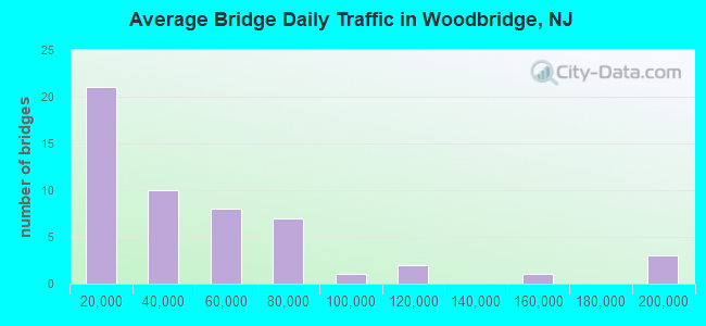
- 2,355,062Total average daily traffic
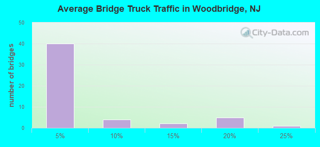
- 187,718Total average daily truck traffic
- National Bridge Inventory (NBI) Registered Bridges for Woodbridge
- No street view available for this location
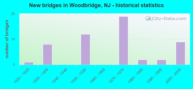
- New bridges - historical statistics
- 11920-1929
- 81930-1939
- 121950-1959
- 191970-1979
- 21980-1989
- 21990-1999
- 92000-2009
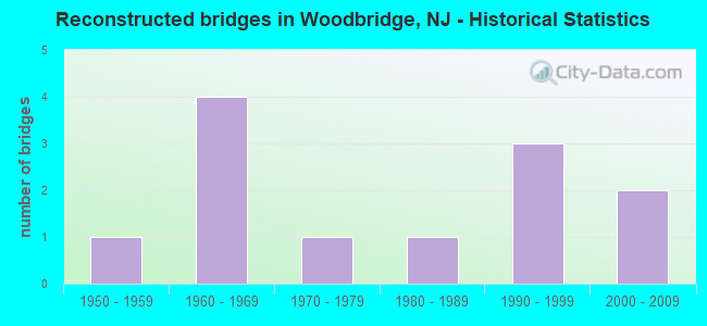
- Reconstructed bridges - Historical Statistics
- 11950-1959
- 41960-1969
- 11970-1979
- 11980-1989
- 31990-1999
- 22000-2009
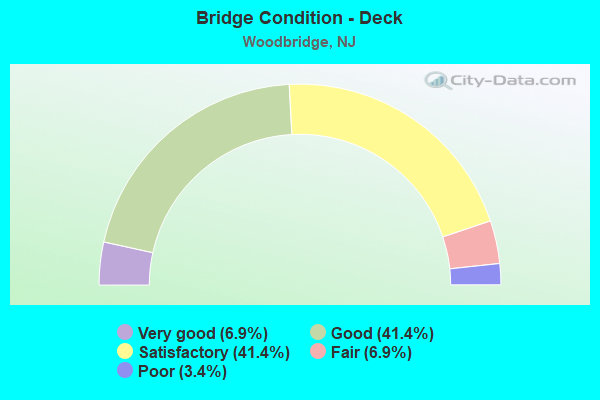
- Bridge Condition - Deck
- 6.9%Very good
- 41.4%Good
- 41.4%Satisfactory
- 6.9%Fair
- 3.4%Poor
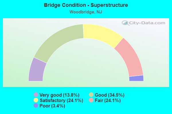
- Bridge Condition - Superstructure
- 13.8%Very good
- 34.5%Good
- 24.1%Satisfactory
- 24.1%Fair
- 3.4%Poor
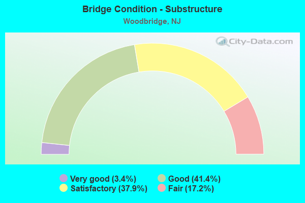
- Bridge Condition - Substructure
- 3.4%Very good
- 41.4%Good
- 37.9%Satisfactory
- 17.2%Fair
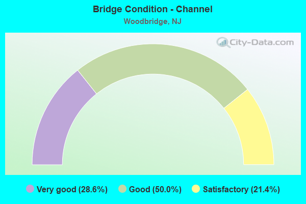
- Bridge Condition - Channel
- 28.6%Very good
- 50.0%Good
- 21.4%Satisfactory
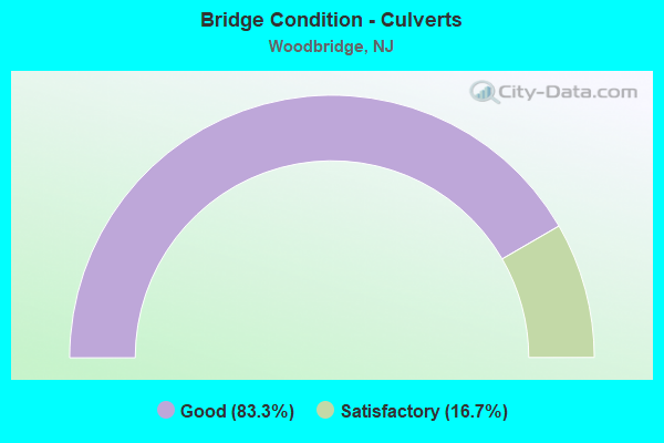
- Bridge Condition - Culverts
- 83.3%Good
- 16.7%Satisfactory
Find on map >> Show street view
Structure Number: 1204153, Location: 0.30 MI SOUTH OF US 9 JCT (Lat: 40.559981, Lng: -74.303319), Route carried "on" structure: US 1, Year Built: 2006, Status: Open, Structure Length: 5.76m (18.90ft), Average Daily Traffic: 62,700 (year 2020), Truck Traffic: 4%, Average Future Daily Traffic: 76,494 (year 2040), Design Load: HL 93, Features Intersected: CONRAIL
Minimum Vertical Clearance: 30+ m (98+ ft), Kilometerpoint: 57.051, Lanes on structure: 7, Base Highway Network: Yes, Owner: State Highway Agency, Approaching Roadway Width: 31.4m (103.0ft), Skew: 32 degrees, Material/Design: Steel continuous, Design/Construction: Stringer/Multi-beam, Number Of Spans In Main Unit: 3, Length of Maximum Span: 20.7m (67.9ft), Curb or Sidewalk Widths: Left: 1.8m (5.9ft), Right: 1.8m (5.9ft), Curb-To-Curb Width: 31.4m (103.0ft), Out-to-Out Width: 37.0m (121.4ft)
Condition: Deck: Good, Superstructure: Good, Substructure: Satisfactory, Operating Rating: 57.3 metric tons, Method Used To Determine Operating Rating: Load and Resistance Factor Rating (LRFR) rating reported by rating factor(RF) method using HL-93 loadings, Inventory Rating: 44.4 metric tons, Method Used To Determine Inventory Rating: Load and Resistance Factor Rating (LRFR) rating reported by rating factor(RF) method using HL-93 loadings, Structural Evaluation: Equal to present minimum criteria, Deck Geometry: Equal to present desirable criteria, Underclear: Better than present minimum criteria, Approach Roadway Alignment: Equal to present desirable criteria, Designated Inspection Frequency: Every 24 months, Inspection Date: May 2020, Deck Structure Type: Concrete Cast-file-Place, Wearing Surface/Protective System: Wearing Surface: Latex Concrete, Deck Protection: Galvanized Reinforcing
Find on map >> Show street view
Structure Number: 1204155, Location: 0.53 MI S OF NJ 35 JCT (Lat: 40.564769, Lng: -74.297819), Route carried "on" structure: US 1, Year Built: 2002, Status: Open, Structure Length: 4.75m (15.58ft), Average Daily Traffic: 68,906 (year 2020), Truck Traffic: 4%, Average Future Daily Traffic: 84,080 (year 2040), Design Load: HL 93, Features Intersected: US 9 SOUTHBOUND
Minimum Vertical Clearance: 30.45m (99.90ft), Kilometerpoint: 57.759, Lanes on structure: 3, Lanes under structure: 2, Base Highway Network: Yes, Owner: State Highway Agency, Approaching Roadway Width: 18.3m (60.0ft), Skew: 6 degrees, Material/Design: Steel, Design/Construction: Stringer/Multi-beam, Number Of Spans In Main Unit: 1, Length of Maximum Span: 45.1m (148.0ft), Curb-To-Curb Width: 18.3m (60.0ft), Out-to-Out Width: 19.4m (63.6ft)
Condition: Deck: Satisfactory, Superstructure: Very good, Substructure: Good, Operating Rating: 58.0 metric tons, Method Used To Determine Operating Rating: Load and Resistance Factor Rating (LRFR) rating reported by rating factor(RF) method using HL-93 loadings, Inventory Rating: 44.7 metric tons, Method Used To Determine Inventory Rating: Load and Resistance Factor Rating (LRFR) rating reported by rating factor(RF) method using HL-93 loadings, Structural Evaluation: Better than present minimum criteria, Deck Geometry: Superior to present desirable criteria, Underclear: Equal to present minimum criteria, Approach Roadway Alignment: Better than present minimum criteria, Designated Inspection Frequency: Every 24 months, Inspection Date: December 2020, Deck Structure Type: Concrete Cast-file-Place, Wearing Surface/Protective System: Wearing Surface: Monolithic Concrete, Deck Protection: Epoxy Coated Reinforcing
Find on map >> Show street view
Structure Number: 120515, Location: 0.5 MI N OF US1-US9 JCT (Lat: 40.571319, Lng: -74.292831), Route carried "on" structure: US 1, Year Built: 2008, Status: Open, Structure Length: 4.05m (13.29ft), Average Daily Traffic: 73,760 (year 2020), Truck Traffic: 4%, Average Future Daily Traffic: 90,000 (year 2040), Design Load: HS 25 or greater, Features Intersected: NJ 35
Minimum Vertical Clearance: 30+ m (98+ ft), Kilometerpoint: 58.612, Lanes on structure: 7, Lanes under structure: 5, Base Highway Network: Yes, Owner: State Highway Agency, Approaching Roadway Width: 35.4m (116.1ft), Skew: 32 degrees, Material/Design: Steel, Design/Construction: Stringer/Multi-beam, Number Of Spans In Main Unit: 1, Length of Maximum Span: 39.6m (129.9ft), Curb-To-Curb Width: 35.4m (116.1ft), Out-to-Out Width: 37.5m (123.0ft)
Condition: Deck: Good, Superstructure: Good, Substructure: Good, Inventory Rating: 63.5 metric tons, Method Used To Determine Inventory Rating: Load Factor (LF), Structural Evaluation: Better than present minimum criteria, Deck Geometry: Superior to present desirable criteria, Underclear: Better than present minimum criteria, Approach Roadway Alignment: Equal to present desirable criteria, Designated Inspection Frequency: Every 24 months, Inspection Date: September 2020, Deck Structure Type: Concrete Cast-file-Place, Wearing Surface/Protective System: Deck Protection: Epoxy Coated Reinforcing
Find on map >> Show street view
Structure Number: 121015, Location: 0.8 MI SOUTH OF RT 1 JCT. (Lat: 40.549950, Lng: -74.290931), Route carried "on" structure: US 9, Year Built: 1937, Year Reconstructed: 2012, Status: Open, Structure Length: 2.41m (7.91ft), Average Daily Traffic: 79,255 (year 2020), Truck Traffic: 4%, Average Future Daily Traffic: 95,106 (year 2040), Design Load: HL 93, Features Intersected: MAIN STREET
Minimum Vertical Clearance: 30+ m (98+ ft), Kilometerpoint: 217.599, Lanes on structure: 4, Lanes under structure: 3, Base Highway Network: Yes, Owner: State Highway Agency, Approaching Roadway Width: 16.5m (54.1ft), Skew: 33 degrees, Material/Design: Steel, Design/Construction: Stringer/Multi-beam, Number Of Spans In Main Unit: 1, Number Of Approach Spans: 2, Length of Maximum Span: 23.5m (77.1ft), Curb or Sidewalk Widths: Left: 1.9m (6.2ft), Right: 1.9m (6.2ft), Curb-To-Curb Width: 15.1m (49.5ft), Out-to-Out Width: 20.8m (68.2ft)
Condition: Deck: Very good, Superstructure: Very good, Substructure: Very good, Operating Rating: 31.4 metric tons, Method Used To Determine Operating Rating: Load and Resistance Factor Rating (LRFR) rating reported by rating factor(RF) method using HL-93 loadings, Inventory Rating: 24.3 metric tons, Method Used To Determine Inventory Rating: Load and Resistance Factor Rating (LRFR) rating reported by rating factor(RF) method using HL-93 loadings, Structural Evaluation: Equal to present minimum criteria, Deck Geometry: High priority of corrective action, Underclear: Equal to present minimum criteria, Approach Roadway Alignment: Superior to present desirable criteria, Designated Inspection Frequency: Every 24 months, Inspection Date: April 2020, Deck Structure Type: Concrete Precast Panels, Wearing Surface/Protective System: Wearing Surface: Bituminous, Membrane: Built-up, Deck Protection: Epoxy Coated Reinforcing
Find on map >> Show street view
Structure Number: 1210151, Location: 0.52 Mi. N. of NJ TPK Jct (Lat: 40.551811, Lng: -74.290969), Route carried "on" structure: US 9, Year Built: 1937, Status: Open, Structure Length: 2.19m (7.19ft), Average Daily Traffic: 79,272 (year 2020), Truck Traffic: 4%, Average Future Daily Traffic: 95,127 (year 2040), Design Load: H 20, Features Intersected: METUCHEN AVENUE
Minimum Vertical Clearance: 30+ m (98+ ft), Kilometerpoint: 217.809, Lanes on structure: 4, Lanes under structure: 2, Base Highway Network: Yes, Owner: State Highway Agency, Approaching Roadway Width: 14.6m (47.9ft), Skew: 30 degrees, Material/Design: Steel, Design/Construction: Stringer/Multi-beam, Number Of Spans In Main Unit: 1, Length of Maximum Span: 20.7m (67.9ft), Curb or Sidewalk Widths: Left: 1.9m (6.2ft), Right: 1.9m (6.2ft), Curb-To-Curb Width: 14.6m (47.9ft), Out-to-Out Width: 21.0m (68.9ft)
Condition: Deck: Fair, Superstructure: Fair, Substructure: Satisfactory, Operating Rating: 75.3 metric tons, Method Used To Determine Operating Rating: Load Factor (LF), Inventory Rating: 44.5 metric tons, Method Used To Determine Inventory Rating: Load Factor (LF), Structural Evaluation: Somewhat better than minimum adequacy, Deck Geometry: High priority of replacement, Underclear: Equal to present minimum criteria, Approach Roadway Alignment: Equal to present desirable criteria, Length Of Structure Improvement: 2.19m (7.19ft), Designated Inspection Frequency: Every 24 months, Inspection Date: April 2020, Bridge Improvement Cost: $37,000, Roadway Improvement Cost: $26,000, Total Project Cost: $88,000 ( Estimate for 2020), Deck Structure Type: Concrete Cast-file-Place, Wearing Surface/Protective System: Wearing Surface: Bituminous, Membrane: Other
Find on map >> Show street view
Structure Number: 1210152, Location: 1.76 mi N of NJ 184 (Lat: 40.558539, Lng: -74.294689), Route carried "on" structure: US 9, Year Built: 1937, Status: Open, Structure Length: 2.04m (6.69ft), Average Daily Traffic: 20,495 (year 2021), Truck Traffic: 4%, Average Future Daily Traffic: 24,595 (year 2041), Design Load: H 20, Features Intersected: CR 604 (Green St)
Minimum Vertical Clearance: 30+ m (98+ ft), Kilometerpoint: 218.597, Lanes on structure: 2, Lanes under structure: 1, Base Highway Network: Yes, Owner: State Highway Agency, Approaching Roadway Width: 9.8m (32.2ft), Skew: 4 degrees, Material/Design: Steel, Design/Construction: Stringer/Multi-beam, Number Of Spans In Main Unit: 1, Length of Maximum Span: 18.6m (61.0ft), Curb or Sidewalk Widths: Left: 0.7m (2.3ft), Right: 1.9m (6.2ft), Curb-To-Curb Width: 9.8m (32.2ft), Out-to-Out Width: 13.2m (43.3ft)
Condition: Deck: Fair, Superstructure: Satisfactory, Substructure: Fair, Operating Rating: 38.1 metric tons, Method Used To Determine Operating Rating: Load Factor (LF), Inventory Rating: 22.7 metric tons, Method Used To Determine Inventory Rating: Load Factor (LF), Structural Evaluation: Somewhat better than minimum adequacy, Deck Geometry: Meets minimum limits, Underclear: Somewhat better than minimum adequacy, Approach Roadway Alignment: Equal to present minimum criteria, Designated Inspection Frequency: Every 24 months, Inspection Date: July 2021, Deck Structure Type: Concrete Cast-file-Place, Wearing Surface/Protective System: Wearing Surface: Bituminous
Find on map >> Show street view
Structure Number: 1210154, Location: 0.3 mi S of US 1 (Lat: 40.561439, Lng: -74.296631), Route carried "on" structure: US 9, Year Built: 1937, Year Reconstructed: 2014, Status: Open, Structure Length: 1.65m (5.41ft), Average Daily Traffic: 26,190 (year 2021), Truck Traffic: 4%, Average Future Daily Traffic: 31,430 (year 2041), Design Load: HL 93, Features Intersected: CR 604 WB (Green St)
Minimum Vertical Clearance: 30+ m (98+ ft), Kilometerpoint: 219.000, Lanes on structure: 2, Lanes under structure: 1, Base Highway Network: Yes, Owner: State Highway Agency, Approaching Roadway Width: 10.1m (33.1ft), Skew: 4 degrees, Material/Design: Steel, Design/Construction: Stringer/Multi-beam, Number Of Spans In Main Unit: 1, Length of Maximum Span: 15.5m (50.9ft), Curb or Sidewalk Widths: Left: 0.0m, Right: 1.8m (5.9ft), Curb-To-Curb Width: 10.2m (33.5ft), Out-to-Out Width: 12.8m (42.0ft)
Condition: Deck: Good, Superstructure: Very good, Substructure: Satisfactory, Operating Rating: 69.0 metric tons, Method Used To Determine Operating Rating: Load and Resistance Factor Rating (LRFR) rating reported by rating factor(RF) method using HL-93 loadings, Inventory Rating: 55.1 metric tons, Method Used To Determine Inventory Rating: Load and Resistance Factor Rating (LRFR) rating reported by rating factor(RF) method using HL-93 loadings, Structural Evaluation: Equal to present minimum criteria, Deck Geometry: Somewhat better than minimum adequacy, Underclear: Somewhat better than minimum adequacy, Approach Roadway Alignment: Equal to present minimum criteria, Designated Inspection Frequency: Every 24 months, Inspection Date: July 2021, Deck Structure Type: Concrete Precast Panels, Wearing Surface/Protective System: Wearing Surface: Bituminous, Membrane: Epoxy, Deck Protection: Epoxy Coated Reinforcing
Find on map >> Show street view
Structure Number: 121B001, Location: 0.32 miles north of CR604 (Lat: 40.578139, Lng: -74.214731), Route carried "on" structure: County highway 602, Year Built: 1978, Status: Open, Structure Length: 1.13m (3.71ft), Average Daily Traffic: 18,539 (year 2021), Truck Traffic: 4%, Average Future Daily Traffic: 22,621 (year 2041), Design Load: HS 20, Features Intersected: NOES CREEK, Facility Carried by Structure: ROOSEVELT AVENUE
Minimum Vertical Clearance: 30+ m (98+ ft), Kilometerpoint: 5.182, Lanes on structure: 2, Owner: County Highway Agency, Approaching Roadway Width: 12.2m (40.0ft), Material/Design: Concrete, Design/Construction: Stringer/Multi-beam, Number Of Spans In Main Unit: 1, Length of Maximum Span: 10.1m (33.1ft), Curb or Sidewalk Widths: Left: 0.3m (1.0ft), Right: 1.8m (5.9ft), Curb-To-Curb Width: 12.2m (40.0ft), Out-to-Out Width: 15.0m (49.2ft)
Condition: Deck: Good, Superstructure: Good, Substructure: Good, Channel: Satisfactory, Operating Rating: 39.0 metric tons, Method Used To Determine Operating Rating: Load Factor (LF), Inventory Rating: 23.6 metric tons, Method Used To Determine Inventory Rating: Load Factor (LF), Structural Evaluation: Somewhat better than minimum adequacy, Deck Geometry: Somewhat better than minimum adequacy, Waterway Adequacy: Better than present minimum criteria, Approach Roadway Alignment: Better than present minimum criteria, Designated Inspection Frequency: Every 24 months, Inspection Date: May 2021, Deck Structure Type: Concrete Cast-file-Place, Wearing Surface/Protective System: Wearing Surface: Monolithic Concrete, Deck Protection: Epoxy Coated Reinforcing
Find on map >> Show street view
Structure Number: 121B007, Location: 0.66 miles north of CR604 (Lat: 40.569819, Lng: -74.259081), Route carried "on" structure: City street , Year Built: 2009, Status: Open, Structure Length: 0.82m (2.69ft), Average Daily Traffic: 4,891 (year 2021), Truck Traffic: 3%, Average Future Daily Traffic: 5,968 (year 2041), Design Load: HS 25 or greater, Features Intersected: BLAIR RD/WOODBRIDGE CRK, Facility Carried by Structure: BLAIR ROAD
Minimum Vertical Clearance: 30+ m (98+ ft), Kilometerpoint: 1.062, Lanes on structure: 2, Owner: County Highway Agency, Approaching Roadway Width: 10.1m (33.1ft), Skew: 1 degrees, Material/Design: Concrete, Design/Construction: Culvert, Number Of Spans In Main Unit: 1, Length of Maximum Span: 8.2m (26.9ft), Curb or Sidewalk Widths: Left: 1.5m (4.9ft), Right: 0.2m (0.7ft), Curb-To-Curb Width: 10.3m (33.8ft), Out-to-Out Width: 12.6m (41.3ft)
Condition: Channel: Very good, Culverts: Good, Inventory Rating: 55.3 metric tons, Method Used To Determine Inventory Rating: Load Factor (LF), Structural Evaluation: Better than present minimum criteria, Deck Geometry: Meets minimum limits, Waterway Adequacy: Superior to present desirable criteria, Approach Roadway Alignment: Better than present minimum criteria, Designated Inspection Frequency: Every 24 months, Inspection Date: May 2021
Find on map >> Show street view
Structure Number: 121B017, Location: 0.3 MI. E. OF RAHWAY AVE. (Lat: 40.562731, Lng: -74.268831), Route carried "on" structure: County highway 604, Year Built: 1988, Status: Open, Structure Length: 1.86m (6.10ft), Average Daily Traffic: 19,491 (year 2021), Truck Traffic: 4%, Average Future Daily Traffic: 23,783 (year 2041), Design Load: HS 20+Mod, Features Intersected: /WOODBRIDGE CREEK, Facility Carried by Structure: PORT READING AVE.
Minimum Vertical Clearance: 30+ m (98+ ft), Kilometerpoint: 11.282, Lanes on structure: 2, Owner: County Highway Agency, Approaching Roadway Width: 13.4m (44.0ft), Material/Design: Prestressed concrete, Design/Construction: Box Beam or Girders - Multiple, Number Of Spans In Main Unit: 1, Length of Maximum Span: 17.7m (58.1ft), Curb or Sidewalk Widths: Left: 1.5m (4.9ft), Right: 1.5m (4.9ft), Curb-To-Curb Width: 13.4m (44.0ft), Out-to-Out Width: 17.1m (56.1ft)
Condition: Deck: Good, Superstructure: Satisfactory, Substructure: Good, Channel: Satisfactory, Operating Rating: 84.4 metric tons, Method Used To Determine Operating Rating: Load Factor (LF), Inventory Rating: 52.6 metric tons, Method Used To Determine Inventory Rating: Load Factor (LF), Structural Evaluation: Equal to present minimum criteria, Deck Geometry: Equal to present minimum criteria, Waterway Adequacy: Somewhat better than minimum adequacy, Approach Roadway Alignment: Equal to present desirable criteria, Designated Inspection Frequency: Every 24 months, Inspection Date: April 2021, Deck Structure Type: Concrete Cast-file-Place, Wearing Surface/Protective System: Wearing Surface: Monolithic Concrete, Deck Protection: Epoxy Coated Reinforcing
Find on map >> Show street view
Structure Number: 121B018, Location: 1.4 MILES EAST OF RTE 1&9 (Lat: 40.562611, Lng: -74.276281), Route carried "on" structure: City street , Year Built: 1979, Status: Open, Structure Length: 0.61m (2.00ft), Average Daily Traffic: 947 (year 2021), Truck Traffic: 1%, Average Future Daily Traffic: 1,136 (year 2041), Design Load: HS 20, Features Intersected: WEDGEWOOD BROOK, Facility Carried by Structure: RIDGEDALE AVENUE
Minimum Vertical Clearance: 30+ m (98+ ft), Kilometerpoint: 0.000, Lanes on structure: 2, Owner: County Highway Agency, Approaching Roadway Width: 12.2m (40.0ft), Material/Design: Concrete, Design/Construction: Culvert, Number Of Spans In Main Unit: 1, Length of Maximum Span: 6.1m (20.0ft), Curb or Sidewalk Widths: Left: 2.5m (8.2ft), Right: 2.5m (8.2ft), Curb-To-Curb Width: 12.1m (39.7ft), Out-to-Out Width: 26.1m (85.6ft)
Condition: Channel: Good, Culverts: Good, Operating Rating: 59.9 metric tons, Method Used To Determine Operating Rating: Load Factor (LF), Inventory Rating: 35.4 metric tons, Method Used To Determine Inventory Rating: Load Factor (LF), Structural Evaluation: Better than present minimum criteria, Deck Geometry: Better than present minimum criteria, Waterway Adequacy: Better than present minimum criteria, Approach Roadway Alignment: Equal to present desirable criteria, Designated Inspection Frequency: Every 24 months, Inspection Date: April 2021, Deck Structure Type: Concrete Cast-file-Place, Wearing Surface/Protective System: Wearing Surface: Bituminous
Find on map >> Show street view
Structure Number: 121B019, Location: 0.02 mile west of CR 514 (Lat: 40.564631, Lng: -74.273931), Route carried "on" structure: City street , Year Built: 2007, Status: Open, Structure Length: 0.85m (2.79ft), Average Daily Traffic: 807 (year 2021), Truck Traffic: 1%, Average Future Daily Traffic: 968 (year 2041), Design Load: HS 25 or greater, Features Intersected: WEDGEWOOD BROOK, Facility Carried by Structure: WEDGEWOOD AVENUE
Minimum Vertical Clearance: 30+ m (98+ ft), Kilometerpoint: 0.000, Lanes on structure: 2, Owner: County Highway Agency, Approaching Roadway Width: 7.3m (24.0ft), Skew: 4 degrees, Material/Design: Concrete, Design/Construction: Culvert, Number Of Spans In Main Unit: 1, Length of Maximum Span: 8.5m (27.9ft), Curb or Sidewalk Widths: Left: 2.7m (8.9ft), Right: 2.7m (8.9ft), Curb-To-Curb Width: 7.4m (24.3ft), Out-to-Out Width: 18.6m (61.0ft)
Condition: Channel: Very good, Culverts: Good, Operating Rating: 75.3 metric tons, Method Used To Determine Operating Rating: Load Factor (LF), Inventory Rating: 45.4 metric tons, Method Used To Determine Inventory Rating: Load Factor (LF), Structural Evaluation: Better than present minimum criteria, Deck Geometry: Meets minimum limits, Waterway Adequacy: Better than present minimum criteria, Approach Roadway Alignment: Better than present minimum criteria, Designated Inspection Frequency: Every 24 months, Inspection Date: April 2021, Deck Structure Type: Concrete Precast Panels, Wearing Surface/Protective System: Wearing Surface: Bituminous
Find on map >> Show street view
Structure Number: 121B02, Location: 1.0 MI NORTH OF RT 35 JCT (Lat: 40.564950, Lng: -74.273150), Route carried "on" structure: County highway 514, Year Built: 1976, Status: Posted for load, Structure Length: 0.64m (2.10ft), Average Daily Traffic: 13,007 (year 2021), Truck Traffic: 4%, Average Future Daily Traffic: 15,871 (year 2041), Design Load: HS 20, Features Intersected: WEDGEWOOD BROOK
Minimum Vertical Clearance: 30+ m (98+ ft), Kilometerpoint: 57.550, Lanes on structure: 2, Owner: County Highway Agency, Approaching Roadway Width: 13.1m (43.0ft), Skew: 2 degrees, Material/Design: Concrete, Design/Construction: Culvert, Number Of Spans In Main Unit: 1, Length of Maximum Span: 6.4m (21.0ft), Curb or Sidewalk Widths: Left: 1.2m (3.9ft), Right: 3.7m (12.1ft), Curb-To-Curb Width: 13.2m (43.3ft), Out-to-Out Width: 26.6m (87.3ft)
Condition: Channel: Good, Culverts: Good, Operating Rating: 54.4 metric tons, Method Used To Determine Operating Rating: Load Factor (LF), Inventory Rating: 32.7 metric tons, Method Used To Determine Inventory Rating: Load Factor (LF), Structural Evaluation: Better than present minimum criteria, Deck Geometry: Somewhat better than minimum adequacy, Waterway Adequacy: Equal to present minimum criteria, Approach Roadway Alignment: Equal to present desirable criteria, Designated Inspection Frequency: Every 24 months, Inspection Date: April 2021, Deck Structure Type: Concrete Cast-file-Place
Find on map >> Show street view
Structure Number: 121B044, Location: 0.4 MILE EAST OF ROUTE 35 (Lat: 40.556681, Lng: -74.276450), Route carried "on" structure: County highway 514, Year Built: 1972, Status: Open, Structure Length: 0.98m (3.22ft), Average Daily Traffic: 13,006 (year 2021), Truck Traffic: 4%, Average Future Daily Traffic: 15,867 (year 2041), Features Intersected: HEARDS BROOK
Minimum Vertical Clearance: 30+ m (98+ ft), Kilometerpoint: 56.568, Lanes on structure: 2, Owner: County Highway Agency, Approaching Roadway Width: 13.4m (44.0ft), Skew: 1 degrees, Material/Design: Concrete, Design/Construction: Culvert, Number Of Spans In Main Unit: 1, Length of Maximum Span: 8.5m (27.9ft), Curb or Sidewalk Widths: Left: 4.6m (15.1ft), Right: 3.8m (12.5ft), Curb-To-Curb Width: 13.4m (44.0ft), Out-to-Out Width: 23.6m (77.4ft)
Condition: Channel: Very good, Culverts: Satisfactory, Operating Rating: 89.8 metric tons, Method Used To Determine Operating Rating: Load Factor (LF), Inventory Rating: 53.5 metric tons, Method Used To Determine Inventory Rating: Load Factor (LF), Structural Evaluation: Equal to present minimum criteria, Deck Geometry: Equal to present minimum criteria, Waterway Adequacy: Superior to present desirable criteria, Approach Roadway Alignment: Better than present minimum criteria, Designated Inspection Frequency: Every 24 months, Inspection Date: June 2021
Find on map >> Show street view
Structure Number: 121B045, Location: 1 MILE NORTH OF I-95 (Lat: 40.556089, Lng: -74.278311), Route carried "on" structure: City street , Year Built: 1972, Status: Open, Structure Length: 0.76m (2.49ft), Average Daily Traffic: 2,336 (year 2021), Truck Traffic: 3%, Average Future Daily Traffic: 2,850 (year 2041), Features Intersected: HEARDS BROOK, Facility Carried by Structure: PEARL STREET
Minimum Vertical Clearance: 30+ m (98+ ft), Kilometerpoint: 0.161, Lanes on structure: 2, Owner: County Highway Agency, Approaching Roadway Width: 9.1m (29.9ft), Material/Design: Concrete, Design/Construction: Culvert, Number Of Spans In Main Unit: 2, Length of Maximum Span: 3.7m (12.1ft), Curb or Sidewalk Widths: Left: 3.3m (10.8ft), Right: 2.0m (6.6ft), Curb-To-Curb Width: 9.3m (30.5ft), Out-to-Out Width: 15.2m (49.9ft)
Condition: Channel: Good, Culverts: Good, Operating Rating: 89.8 metric tons, Method Used To Determine Operating Rating: Load Factor (LF), Inventory Rating: 62.6 metric tons, Method Used To Determine Inventory Rating: Load Factor (LF), Structural Evaluation: Better than present minimum criteria, Deck Geometry: Meets minimum limits, Waterway Adequacy: Superior to present desirable criteria, Approach Roadway Alignment: Equal to present desirable criteria, Designated Inspection Frequency: Every 24 months, Inspection Date: June 2021
Find on map >> Show street view
Structure Number: 121B046, Location: 0.4 MILE EAST OF ROUTE 35 (Lat: 40.556131, Lng: -74.280319), Route carried "on" structure: City street , Year Built: 1978, Status: Open, Structure Length: 1.43m (4.69ft), Average Daily Traffic: 833 (year 2021), Truck Traffic: 1%, Average Future Daily Traffic: 1,017 (year 2041), Design Load: HS 20, Features Intersected: HEARDS BROOK, Facility Carried by Structure: SCHOOL STREET
Minimum Vertical Clearance: 30+ m (98+ ft), Kilometerpoint: 0.177, Lanes on structure: 2, Owner: County Highway Agency, Approaching Roadway Width: 11.0m (36.1ft), Skew: 1 degrees, Material/Design: Concrete continuous, Design/Construction: Slab, Number Of Spans In Main Unit: 2, Length of Maximum Span: 7.0m (23.0ft), Curb or Sidewalk Widths: Left: 3.3m (10.8ft), Right: 3.3m (10.8ft), Curb-To-Curb Width: 11.0m (36.1ft), Out-to-Out Width: 18.3m (60.0ft)
Condition: Deck: Good, Superstructure: Good, Substructure: Good, Channel: Good, Operating Rating: 81.6 metric tons, Method Used To Determine Operating Rating: Load Factor (LF), Inventory Rating: 49.0 metric tons, Method Used To Determine Inventory Rating: Load Factor (LF), Structural Evaluation: Better than present minimum criteria, Deck Geometry: Better than present minimum criteria, Waterway Adequacy: Equal to present desirable criteria, Approach Roadway Alignment: Equal to present desirable criteria, Designated Inspection Frequency: Every 24 months, Inspection Date: April 2021, Deck Structure Type: Concrete Cast-file-Place, Wearing Surface/Protective System: Wearing Surface: Bituminous
Find on map >> Show street view
Structure Number: 121B047, Location: 0.2 MILE WEST OF ROUTE 35 (Lat: 40.555431, Lng: -74.285931), Route carried "on" structure: City street , Year Built: 1978, Status: Open, Structure Length: 1.43m (4.69ft), Average Daily Traffic: 765 (year 2021), Truck Traffic: 1%, Average Future Daily Traffic: 934 (year 2041), Design Load: HS 20, Features Intersected: HEARDS BROOK, Facility Carried by Structure: ELMWOOD AVENUE
Minimum Vertical Clearance: 30+ m (98+ ft), Kilometerpoint: 0.322, Lanes on structure: 2, Owner: County Highway Agency, Approaching Roadway Width: 9.1m (29.9ft), Skew: 1 degrees, Material/Design: Concrete continuous, Design/Construction: Slab, Number Of Spans In Main Unit: 2, Length of Maximum Span: 7.0m (23.0ft), Curb or Sidewalk Widths: Left: 1.8m (5.9ft), Right: 1.8m (5.9ft), Curb-To-Curb Width: 9.2m (30.2ft), Out-to-Out Width: 15.9m (52.2ft)
Condition: Deck: Good, Superstructure: Good, Substructure: Good, Channel: Satisfactory, Operating Rating: 88.9 metric tons, Method Used To Determine Operating Rating: Load Factor (LF), Inventory Rating: 53.5 metric tons, Method Used To Determine Inventory Rating: Load Factor (LF), Structural Evaluation: Better than present minimum criteria, Deck Geometry: Equal to present minimum criteria, Waterway Adequacy: Equal to present desirable criteria, Approach Roadway Alignment: Equal to present desirable criteria, Designated Inspection Frequency: Every 24 months, Inspection Date: April 2021, Deck Structure Type: Concrete Cast-file-Place, Wearing Surface/Protective System: Wearing Surface: Bituminous
Find on map >> Show street view
Structure Number: 121B504, Location: 0.4 MI WEST OF US 9 JCT (Lat: 40.546531, Lng: -74.297700), Route carried "on" structure: County highway 514, Year Built: 2003, Status: Open, Structure Length: 3.41m (11.19ft), Average Daily Traffic: 20,164 (year 2021), Truck Traffic: 4%, Average Future Daily Traffic: 24,600 (year 2041), Design Load: HS 25 or greater, Features Intersected: WOODBRIDGE CTR DR.
Minimum Vertical Clearance: 30.18m (99.02ft), Kilometerpoint: 54.348, Lanes on structure: 5, Lanes under structure: 5, Base Highway Network: Yes, Owner: County Highway Agency, Approaching Roadway Width: 21.6m (70.9ft), Skew: 20 degrees, Material/Design: Prestressed concrete, Design/Construction: Box Beam or Girders - Multiple, Number Of Spans In Main Unit: 1, Length of Maximum Span: 31.7m (104.0ft), Curb or Sidewalk Widths: Left: 1.8m (5.9ft), Right: 1.8m (5.9ft), Curb-To-Curb Width: 21.3m (69.9ft), Out-to-Out Width: 27.0m (88.6ft)
Condition: Deck: Satisfactory, Superstructure: Good, Substructure: Good, Operating Rating: 89.8 metric tons, Method Used To Determine Operating Rating: Load Factor (LF), Inventory Rating: 87.1 metric tons, Method Used To Determine Inventory Rating: Load Factor (LF), Structural Evaluation: Better than present minimum criteria, Deck Geometry: Somewhat better than minimum adequacy, Underclear: Somewhat better than minimum adequacy, Approach Roadway Alignment: Equal to present desirable criteria, Designated Inspection Frequency: Every 24 months, Inspection Date: June 2021, Deck Structure Type: Concrete Cast-file-Place, Wearing Surface/Protective System: Wearing Surface: Monolithic Concrete, Deck Protection: Epoxy Coated Reinforcing
Find on map >> Show street view
Structure Number: 1254164, Location: 0.4MI NW OF US9&NJ440 JCT (Lat: 40.523931, Lng: -74.305869), Route carried "on" structure: County highway 629, Year Built: 1983, Status: Open, Structure Length: 4.42m (14.50ft), Average Daily Traffic: 3,763 (year 2021), Truck Traffic: 4%, Average Future Daily Traffic: 4,592 (year 2041), Design Load: HS 20+Mod, Features Intersected: PERTH AMBOY BRCH (ABDND)
Minimum Vertical Clearance: 30+ m (98+ ft), Kilometerpoint: 0.161, Lanes on structure: 2, Maintenance Responsibility: State Highway Agency, Approaching Roadway Width: 13.7m (44.9ft), Skew: 1 degrees, Material/Design: Prestressed concrete, Design/Construction: Box Beam or Girders - Multiple, Number Of Spans In Main Unit: 3, Length of Maximum Span: 15.8m (51.8ft), Curb or Sidewalk Widths: Left: 1.8m (5.9ft), Right: 1.8m (5.9ft), Curb-To-Curb Width: 13.8m (45.3ft), Out-to-Out Width: 18.3m (60.0ft)
Condition: Deck: Satisfactory, Superstructure: Good, Substructure: Good, Operating Rating: 87.1 metric tons, Method Used To Determine Operating Rating: Load Factor (LF), Inventory Rating: 52.6 metric tons, Method Used To Determine Inventory Rating: Load Factor (LF), Structural Evaluation: Better than present minimum criteria, Deck Geometry: Superior to present desirable criteria, Approach Roadway Alignment: Somewhat better than minimum adequacy, Designated Inspection Frequency: Every 24 months, Inspection Date: September 2021, Deck Structure Type: Concrete Cast-file-Place, Wearing Surface/Protective System: Wearing Surface: Monolithic Concrete, Deck Protection: Epoxy Coated Reinforcing
Find on map >> Show street view
Structure Number: 1260164, Location: .3 MI EAST OF NJ 35 (Lat: 40.544250, Lng: -74.271819), Route carried "on" structure: City street , Year Built: 1927, Year Reconstructed: 1965, Status: Open, Structure Length: 2.71m (8.89ft), Average Daily Traffic: 367 (year 2020), Truck Traffic: 3%, Average Future Daily Traffic: 440 (year 2040), Design Load: H 20, Features Intersected: NORTH JERSEY COAST LINE, Facility Carried by Structure: CUTTERS DOCK ROAD
Minimum Vertical Clearance: 30+ m (98+ ft), Kilometerpoint: 0.322, Lanes on structure: 2, Owner: State Agenciy, Approaching Roadway Width: 8.5m (27.9ft), Material/Design: Steel continuous, Design/Construction: Stringer/Multi-beam, Number Of Spans In Main Unit: 3, Length of Maximum Span: 10.4m (34.1ft), Curb or Sidewalk Widths: Left: 0.2m (0.7ft), Right: 0.0m, Curb-To-Curb Width: 6.0m (19.7ft), Out-to-Out Width: 6.6m (21.7ft)
Condition: Deck: Poor, Superstructure: Poor, Substructure: Fair, Operating Rating: 38.1 metric tons, Method Used To Determine Operating Rating: Load Factor (LF), Inventory Rating: 22.7 metric tons, Method Used To Determine Inventory Rating: Load Factor (LF), Structural Evaluation: Meets minimum limits, Deck Geometry: High priority of corrective action, Underclear: High priority of replacement, Approach Roadway Alignment: Somewhat better than minimum adequacy, Length Of Structure Improvement: 3.54m (11.61ft), Designated Inspection Frequency: Every 24 months, Inspection Date: October 2020, Bridge Improvement Cost: $2,294,000, Roadway Improvement Cost: $230,000, Total Project Cost: $4,199,000 ( Estimate for 2020), Deck Structure Type: Corrugated Steel, Wearing Surface/Protective System: Wearing Surface: Bituminous
Find on map >> Show street view
Structure Number: 361287N, Location: .75 MI N OF GSP&RT440 JCT (Lat: 40.529967, Lng: -74.298064), Route carried "on" structure: Other road GSP, Year Built: 1953, Year Reconstructed: 1968, Status: Open, Structure Length: 5.18m (16.99ft), Average Daily Traffic: 76,297 (year 2021), Truck Traffic: 1%, Average Future Daily Traffic: 93,097 (year 2041), Design Load: H 20, Features Intersected: US ROUTE 9 (SB)
Minimum Vertical Clearance: 30+ m (98+ ft), Kilometerpoint: 207.123, Lanes on structure: 5, Lanes under structure: 3, Base Highway Network: Yes, Toll: On toll road, Owner: State Toll Authority, Approaching Roadway Width: 22.3m (73.2ft), Skew: 7 degrees, Material/Design: Steel, Design/Construction: Stringer/Multi-beam, Number Of Spans In Main Unit: 1, Length of Maximum Span: 51.2m (168.0ft), Curb or Sidewalk Widths: Left: 0.5m (1.6ft), Right: 0.5m (1.6ft), Curb-To-Curb Width: 22.3m (73.2ft), Out-to-Out Width: 23.9m (78.4ft)
Condition: Deck: Satisfactory, Superstructure: Satisfactory, Substructure: Satisfactory, Operating Rating: 25.6 metric tons, Method Used To Determine Operating Rating: Load and Resistance Factor Rating (LRFR) rating reported by rating factor(RF) method using HL-93 loadings, Inventory Rating: 19.8 metric tons, Method Used To Determine Inventory Rating: Load and Resistance Factor Rating (LRFR) rating reported by rating factor(RF) method using HL-93 loadings, Structural Evaluation: Somewhat better than minimum adequacy, Deck Geometry: Meets minimum limits, Underclear: Equal to present minimum criteria, Approach Roadway Alignment: Equal to present desirable criteria, Designated Inspection Frequency: Every 24 months, Inspection Date: March 2021, Deck Structure Type: Concrete Cast-file-Place, Wearing Surface/Protective System: Wearing Surface: Bituminous, Membrane: Preformed Fabric
Find on map >> Show street view
Structure Number: M09102A, Location: 0.25 MI W OF ROUTE 9 (Lat: 40.543797, Lng: -74.294281), Route carried "on" structure: Interstate 95, Year Built: 1970, Status: Open, Structure Length: 5.30m (17.39ft), Average Daily Traffic: 40,700 (year 2021), Truck Traffic: 17%, Average Future Daily Traffic: 48,900 (year 2041), Design Load: HS 20, Features Intersected: NJ TPK INTER.11 RAMP TSO, Facility Carried by Structure: NJTPK NSO ROADWAY
Minimum Vertical Clearance: 30+ m (98+ ft), Kilometerpoint: 73.467, Lanes on structure: 3, Lanes under structure: 1, Base Highway Network: Yes, Toll: On toll road, Owner: State Toll Authority, Approaching Roadway Width: 16.2m (53.1ft), Skew: 3 degrees, Material/Design: Steel, Design/Construction: Stringer/Multi-beam, Number Of Spans In Main Unit: 3, Length of Maximum Span: 27.4m (89.9ft), Curb or Sidewalk Widths: Left: 0.6m (2.0ft), Right: 0.6m (2.0ft), Curb-To-Curb Width: 16.2m (53.1ft), Out-to-Out Width: 18.0m (59.1ft)
Condition: Deck: Satisfactory, Superstructure: Fair, Substructure: Satisfactory, Operating Rating: 43.7 metric tons, Method Used To Determine Operating Rating: Load and Resistance Factor Rating (LRFR) rating reported by rating factor(RF) method using HL-93 loadings, Inventory Rating: 33.7 metric tons, Method Used To Determine Inventory Rating: Load and Resistance Factor Rating (LRFR) rating reported by rating factor(RF) method using HL-93 loadings, Structural Evaluation: Somewhat better than minimum adequacy, Deck Geometry: Equal to present minimum criteria, Underclear: Somewhat better than minimum adequacy, Approach Roadway Alignment: Equal to present desirable criteria, Designated Inspection Frequency: Every 24 months, Inspection Date: May 2021, Deck Structure Type: Concrete Cast-file-Place, Wearing Surface/Protective System: Wearing Surface: Bituminous, Membrane: Other
Find on map >> Show street view
Structure Number: M09113, Location: .9 MI E RTE 444 & NJ TPK (Lat: 40.543519, Lng: -74.291600), Route carried "on" structure: US 9, Year Built: 1951, Year Reconstructed: 1969, Status: Open, Structure Length: 10.61m (34.81ft), Average Daily Traffic: 70,000 (year 2021), Truck Traffic: 3%, Average Future Daily Traffic: 84,000 (year 2041), Design Load: HS 20, Features Intersected: NJ TPK NSI-SNI-SNO RWYS
Minimum Vertical Clearance: 30+ m (98+ ft), Kilometerpoint: 216.859, Lanes on structure: 6, Lanes under structure: 9, Base Highway Network: Yes, Owner: State Toll Authority, Approaching Roadway Width: 33.2m (108.9ft), Skew: 32 degrees, Material/Design: Steel, Design/Construction: Stringer/Multi-beam, Number Of Spans In Main Unit: 6, Length of Maximum Span: 25.3m (83.0ft), Curb or Sidewalk Widths: Left: 2.1m (6.9ft), Right: 4.3m (14.1ft), Curb-To-Curb Width: 26.2m (86.0ft), Out-to-Out Width: 33.8m (110.9ft)
Condition: Deck: Satisfactory, Superstructure: Fair, Substructure: Fair, Operating Rating: 31.8 metric tons, Method Used To Determine Operating Rating: Load and Resistance Factor Rating (LRFR) rating reported by rating factor(RF) method using HL-93 loadings, Inventory Rating: 24.6 metric tons, Method Used To Determine Inventory Rating: Load and Resistance Factor Rating (LRFR) rating reported by rating factor(RF) method using HL-93 loadings, Structural Evaluation: Somewhat better than minimum adequacy, Deck Geometry: Equal to present minimum criteria, Underclear: High priority of corrective action, Approach Roadway Alignment: Equal to present desirable criteria, Designated Inspection Frequency: Every 24 months, Inspection Date: May 2021, Deck Structure Type: Concrete Cast-file-Place, Wearing Surface/Protective System: Wearing Surface: Bituminous
Find on map >> Show street view
Structure Number: M09115S, Location: .9 MI E RTE 444 & NJ TPK (Lat: 40.545000, Lng: -74.291667), Route carried "on" structure: Interstate 95, Year Built: 1951, Year Reconstructed: 1955, Status: Open, Structure Length: 5.52m (18.11ft), Average Daily Traffic: 47,447 (year 2021), Truck Traffic: 17%, Average Future Daily Traffic: 57,894 (year 2041), Design Load: HS 20, Features Intersected: US RTE 9, Facility Carried by Structure: NJ TPK NSO RWY
Minimum Vertical Clearance: 30+ m (98+ ft), Kilometerpoint: 73.692, Lanes on structure: 3, Lanes under structure: 6, Base Highway Network: Yes, Toll: On toll road, Owner: State Toll Authority, Approaching Roadway Width: 16.2m (53.1ft), Skew: 2 degrees, Material/Design: Steel, Design/Construction: Stringer/Multi-beam, Number Of Spans In Main Unit: 4, Length of Maximum Span: 18.9m (62.0ft), Curb or Sidewalk Widths: Left: 0.0m, Right: 0.6m (2.0ft), Curb-To-Curb Width: 16.2m (53.1ft), Out-to-Out Width: 18.0m (59.1ft)
Condition: Deck: Satisfactory, Superstructure: Satisfactory, Substructure: Satisfactory, Operating Rating: 58.0 metric tons, Method Used To Determine Operating Rating: Load and Resistance Factor Rating (LRFR) rating reported by rating factor(RF) method using HL-93 loadings, Inventory Rating: 44.7 metric tons, Method Used To Determine Inventory Rating: Load and Resistance Factor Rating (LRFR) rating reported by rating factor(RF) method using HL-93 loadings, Structural Evaluation: Equal to present minimum criteria, Deck Geometry: Equal to present minimum criteria, Underclear: Somewhat better than minimum adequacy, Approach Roadway Alignment: Better than present minimum criteria, Designated Inspection Frequency: Every 24 months, Inspection Date: April 2021, Deck Structure Type: Concrete Cast-file-Place, Wearing Surface/Protective System: Wearing Surface: Bituminous, Membrane: Other
Find on map >> Show street view
Structure Number: M09132A, Location: 1.1 MI E RTE 444 & NJ TPK (Lat: 40.543333, Lng: -74.288333), Route carried "on" structure: Ramp Interstate 95, Year Built: 1970, Status: Open, Structure Length: 16.31m (53.51ft), Average Daily Traffic: 20,072 (year 2021), Truck Traffic: 11%, Average Future Daily Traffic: 24,492 (year 2041), Design Load: HS 20, Features Intersected: NJ TURNPIKE, Facility Carried by Structure: NJTPK INT.11 R.N0T
Minimum Vertical Clearance: 30+ m (98+ ft), Kilometerpoint: 73.965, Lanes on structure: 2, Lanes under structure: 12, Toll: On toll road, Owner: State Toll Authority, Approaching Roadway Width: 11.0m (36.1ft), Skew: 2 degrees, Material/Design: Steel, Design/Construction: Stringer/Multi-beam, Number Of Spans In Main Unit: 8, Length of Maximum Span: 23.2m (76.1ft), Curb or Sidewalk Widths: Left: 0.6m (2.0ft), Right: 0.6m (2.0ft), Curb-To-Curb Width: 11.0m (36.1ft), Out-to-Out Width: 12.8m (42.0ft)
Condition: Deck: Satisfactory, Superstructure: Satisfactory, Substructure: Fair, Operating Rating: 53.1 metric tons, Method Used To Determine Operating Rating: Load and Resistance Factor Rating (LRFR) rating reported by rating factor(RF) method using HL-93 loadings, Inventory Rating: 40.8 metric tons, Method Used To Determine Inventory Rating: Load and Resistance Factor Rating (LRFR) rating reported by rating factor(RF) method using HL-93 loadings, Structural Evaluation: Somewhat better than minimum adequacy, Deck Geometry: Better than present minimum criteria, Underclear: High priority of corrective action, Approach Roadway Alignment: Equal to present desirable criteria, Designated Inspection Frequency: Every 24 months, Inspection Date: May 2021, Deck Structure Type: Concrete Cast-file-Place, Wearing Surface/Protective System: Wearing Surface: Bituminous, Membrane: Epoxy
Find on map >> Show street view
Structure Number: M09136A, Location: 1.15 MI E RT. 444 & NJTPK (Lat: 40.545533, Lng: -74.286153), Route carried "on" structure: Ramp Interstate 95, Year Built: 1970, Status: Open, Structure Length: 25.09m (82.32ft), Average Daily Traffic: 24,500 (year 2021), Truck Traffic: 1%, Average Future Daily Traffic: 29,400 (year 2041), Design Load: HS 20, Features Intersected: NJTPK NSI-SNI-SNO RWYS, Facility Carried by Structure: NJTPK INT.11 R.NIT
Minimum Vertical Clearance: 30+ m (98+ ft), Kilometerpoint: 73.965, Lanes on structure: 2, Lanes under structure: 9, Toll: On toll road, Owner: State Toll Authority, Approaching Roadway Width: 11.0m (36.1ft), Skew: 9 degrees, Material/Design: Steel, Design/Construction: Stringer/Multi-beam, Number Of Spans In Main Unit: 11, Length of Maximum Span: 23.8m (78.1ft), Curb or Sidewalk Widths: Left: 0.6m (2.0ft), Right: 0.6m (2.0ft), Curb-To-Curb Width: 11.0m (36.1ft), Out-to-Out Width: 12.8m (42.0ft)
Condition: Deck: Satisfactory, Superstructure: Fair, Substructure: Satisfactory, Operating Rating: 51.5 metric tons, Method Used To Determine Operating Rating: Load and Resistance Factor Rating (LRFR) rating reported by rating factor(RF) method using HL-93 loadings, Inventory Rating: 39.5 metric tons, Method Used To Determine Inventory Rating: Load and Resistance Factor Rating (LRFR) rating reported by rating factor(RF) method using HL-93 loadings, Structural Evaluation: Somewhat better than minimum adequacy, Deck Geometry: Better than present minimum criteria, Underclear: Meets minimum limits, Approach Roadway Alignment: Equal to present desirable criteria, Designated Inspection Frequency: Every 24 months, Critical Feature Inspection Frequency: Every 24 months, Inspection Date: May 2021, Critical Feature Inspection Date: May 2021, Deck Structure Type: Concrete Cast-file-Place, Wearing Surface/Protective System: Wearing Surface: Bituminous, Membrane: Epoxy
Find on map >> Show street view
Structure Number: M09137A, Location: 1.2 MI E RTE 444 & NJ TPK (Lat: 40.545000, Lng: -74.286667), Route carried "on" structure: Ramp Interstate 95, Year Built: 1970, Status: Open, Structure Length: 6.25m (20.51ft), Average Daily Traffic: 22,695 (year 2021), Truck Traffic: 1%, Average Future Daily Traffic: 27,234 (year 2041), Design Load: HS 20, Features Intersected: NJ TURNPIKE SNO RWY, Facility Carried by Structure: NJTPK INT.11 R.TNI
Minimum Vertical Clearance: 30+ m (98+ ft), Kilometerpoint: 73.965, Lanes on structure: 2, Lanes under structure: 3, Toll: On toll road, Owner: State Toll Authority, Approaching Roadway Width: 11.0m (36.1ft), Skew: 4 degrees, Material/Design: Steel, Design/Construction: Stringer/Multi-beam, Number Of Spans In Main Unit: 3, Length of Maximum Span: 37.2m (122.0ft), Curb or Sidewalk Widths: Left: 0.6m (2.0ft), Right: 0.6m (2.0ft), Curb-To-Curb Width: 11.0m (36.1ft), Out-to-Out Width: 12.8m (42.0ft)
Condition: Deck: Good, Superstructure: Fair, Substructure: Satisfactory, Operating Rating: 24.9 metric tons, Method Used To Determine Operating Rating: Load and Resistance Factor Rating (LRFR) rating reported by rating factor(RF) method using HL-93 loadings, Inventory Rating: 19.1 metric tons, Method Used To Determine Inventory Rating: Load and Resistance Factor Rating (LRFR) rating reported by rating factor(RF) method using HL-93 loadings, Structural Evaluation: Meets minimum limits, Deck Geometry: Better than present minimum criteria, Underclear: Equal to present minimum criteria, Approach Roadway Alignment: Equal to present desirable criteria, Designated Inspection Frequency: Every 24 months, Inspection Date: May 2021, Deck Structure Type: Concrete Cast-file-Place, Wearing Surface/Protective System: Wearing Surface: Bituminous, Membrane: Epoxy
Find on map >> Show street view
Structure Number: M09189, Location: 1.65 MI E RT 444 & NJ TPK (Lat: 40.548333, Lng: -74.280000), Route carried "on" structure: State highway 35, Year Built: 1950, Year Reconstructed: 1990, Status: Open, Structure Length: 10.67m (35.01ft), Average Daily Traffic: 30,275 (year 2021), Truck Traffic: 3%, Average Future Daily Traffic: 36,330 (year 2041), Design Load: HS 20, Features Intersected: NJ TURNPIKE
Minimum Vertical Clearance: 30+ m (98+ ft), Kilometerpoint: 87.999, Lanes on structure: 4, Lanes under structure: 16, Base Highway Network: Yes, Owner: State Toll Authority, Approaching Roadway Width: 14.0m (45.9ft), Skew: 1 degrees, Material/Design: Steel, Design/Construction: Stringer/Multi-beam, Number Of Spans In Main Unit: 4, Length of Maximum Span: 24.1m (79.1ft), Curb or Sidewalk Widths: Left: 3.0m (9.8ft), Right: 3.0m (9.8ft), Curb-To-Curb Width: 14.0m (45.9ft), Out-to-Out Width: 20.7m (67.9ft)
Condition: Deck: Good, Superstructure: Satisfactory, Substructure: Fair, Operating Rating: 35.6 metric tons, Method Used To Determine Operating Rating: Load and Resistance Factor Rating (LRFR) rating reported by rating factor(RF) method using HL-93 loadings, Inventory Rating: 27.5 metric tons, Method Used To Determine Inventory Rating: Load and Resistance Factor Rating (LRFR) rating reported by rating factor(RF) method using HL-93 loadings, Structural Evaluation: Somewhat better than minimum adequacy, Deck Geometry: High priority of replacement, Underclear: High priority of corrective action, Approach Roadway Alignment: Equal to present desirable criteria, Length Of Structure Improvement: 10.67m (35.01ft), Designated Inspection Frequency: Every 24 months, Inspection Date: April 2021, Bridge Improvement Cost: $400,000, Roadway Improvement Cost: $100,000, Total Project Cost: $700,000, Deck Structure Type: Concrete Cast-file-Place, Wearing Surface/Protective System: Wearing Surface: Bituminous
Find on map >> Show street view
Structure Number: M09208W, Location: 1.8 MI E RTE.444 & NJ TPK (Lat: 40.551528, Lng: -74.276639), Route carried "on" structure: City street , Year Built: 1950, Status: Open, Structure Length: 1.77m (5.81ft), Average Daily Traffic: 1,571 (year 2021), Truck Traffic: 1%, Average Future Daily Traffic: 1,918 (year 2041), Design Load: H 20, Features Intersected: LEGION PLACE, Facility Carried by Structure: FULTON STREET
Minimum Vertical Clearance: 30+ m (98+ ft), Kilometerpoint: 0.370, Lanes on structure: 2, Lanes under structure: 2, Owner: State Toll Authority, Approaching Roadway Width: 9.1m (29.9ft), Material/Design: Steel, Design/Construction: Stringer/Multi-beam, Number Of Spans In Main Unit: 1, Length of Maximum Span: 17.1m (56.1ft), Curb or Sidewalk Widths: Left: 1.8m (5.9ft), Right: 0.6m (2.0ft), Curb-To-Curb Width: 9.3m (30.5ft), Out-to-Out Width: 12.3m (40.4ft)
Condition: Deck: Satisfactory, Superstructure: Satisfactory, Substructure: Satisfactory, Operating Rating: 56.4 metric tons, Method Used To Determine Operating Rating: Load and Resistance Factor Rating (LRFR) rating reported by rating factor(RF) method using HL-93 loadings, Inventory Rating: 43.4 metric tons, Method Used To Determine Inventory Rating: Load and Resistance Factor Rating (LRFR) rating reported by rating factor(RF) method using HL-93 loadings, Structural Evaluation: Equal to present minimum criteria, Deck Geometry: Somewhat better than minimum adequacy, Underclear: Equal to present minimum criteria, Approach Roadway Alignment: Equal to present desirable criteria, Designated Inspection Frequency: Every 24 months, Inspection Date: March 2021, Deck Structure Type: Concrete Cast-file-Place
Find on map >> Show street view
Structure Number: M09211A, Location: 1.86 MI E RT.444 & NJ TPK (Lat: 40.550853, Lng: -74.275661), Route carried "on" structure: Ramp Interstate 95, Year Built: 1991, Status: Open, Structure Length: 8.41m (27.59ft), Average Daily Traffic: 350 (year 2021), Truck Traffic: 1%, Average Future Daily Traffic: 420 (year 2041), Design Load: HS 20, Features Intersected: NJ TURNPIKE, Facility Carried by Structure: NJ TPK MP 92 U-TRN
Minimum Vertical Clearance: 30+ m (98+ ft), Kilometerpoint: 75.253, Lanes on structure: 2, Lanes under structure: 14, Toll: On toll road, Owner: State Toll Authority, Approaching Roadway Width: 7.9m (25.9ft), Skew: 1 degrees, Material/Design: Steel continuous, Design/Construction: Stringer/Multi-beam, Number Of Spans In Main Unit: 4, Length of Maximum Span: 21.6m (70.9ft), Curb-To-Curb Width: 7.9m (25.9ft), Out-to-Out Width: 9.1m (29.9ft)
Condition: Deck: Good, Superstructure: Good, Substructure: Good, Operating Rating: 68.7 metric tons, Method Used To Determine Operating Rating: Load and Resistance Factor Rating (LRFR) rating reported by rating factor(RF) method using HL-93 loadings, Inventory Rating: 52.8 metric tons, Method Used To Determine Inventory Rating: Load and Resistance Factor Rating (LRFR) rating reported by rating factor(RF) method using HL-93 loadings, Structural Evaluation: Better than present minimum criteria, Deck Geometry: High priority of replacement, Underclear: High priority of corrective action, Approach Roadway Alignment: Better than present minimum criteria, Length Of Structure Improvement: 9.60m (31.50ft), Designated Inspection Frequency: Every 24 months, Inspection Date: June 2021, Bridge Improvement Cost: $186,000, Roadway Improvement Cost: $32,000, Total Project Cost: $318,000 ( Estimate for 2017), Deck Structure Type: Concrete Cast-file-Place, Wearing Surface/Protective System: Wearing Surface: Latex Concrete, Deck Protection: Epoxy Coated Reinforcing
Find on map >> Show street view
Structure Number: M09251, Location: 0.6 MI NORTH OF NJ 35 (Lat: 40.553333, Lng: -74.270000), Route carried "on" structure: County highway 652, Year Built: 1970, Year Reconstructed: 1992, Status: Open, Structure Length: 16.31m (53.51ft), Average Daily Traffic: 7,470 (year 2021), Truck Traffic: 3%, Average Future Daily Traffic: 9,113 (year 2041), Design Load: HS 20, Features Intersected: NJ TPK RWYS & RAMPS, Facility Carried by Structure: WOODBRIDGE AVENUE
Minimum Vertical Clearance: 30+ m (98+ ft), Kilometerpoint: 0.933, Lanes on structure: 2, Lanes under structure: 17, Owner: State Toll Authority, Approaching Roadway Width: 12.2m (40.0ft), Skew: 3 degrees, Material/Design: Steel, Design/Construction: Stringer/Multi-beam, Number Of Spans In Main Unit: 4, Length of Maximum Span: 42.1m (138.1ft), Curb or Sidewalk Widths: Left: 1.8m (5.9ft), Right: 1.8m (5.9ft), Curb-To-Curb Width: 12.2m (40.0ft), Out-to-Out Width: 16.5m (54.1ft)
Condition: Deck: Satisfactory, Superstructure: Fair, Substructure: Satisfactory, Operating Rating: 53.1 metric tons, Method Used To Determine Operating Rating: Load and Resistance Factor Rating (LRFR) rating reported by rating factor(RF) method using HL-93 loadings, Inventory Rating: 40.8 metric tons, Method Used To Determine Inventory Rating: Load and Resistance Factor Rating (LRFR) rating reported by rating factor(RF) method using HL-93 loadings, Structural Evaluation: Somewhat better than minimum adequacy, Deck Geometry: Somewhat better than minimum adequacy, Underclear: Meets minimum limits, Approach Roadway Alignment: Equal to present desirable criteria, Designated Inspection Frequency: Every 24 months, Inspection Date: March 2021, Deck Structure Type: Concrete Cast-file-Place, Wearing Surface/Protective System: Wearing Surface: Latex Concrete
Find on map >> Show street view
Structure Number: M09265N, Location: 2.4 MI E RTE 444 & NJTPK (Lat: 40.556667, Lng: -74.268333), Route carried "on" structure: Interstate 95, Year Built: 1950, Year Reconstructed: 1969, Status: Open, Structure Length: 1.80m (5.91ft), Average Daily Traffic: 54,353 (year 2021), Truck Traffic: 2%, Average Future Daily Traffic: 66,309 (year 2041), Design Load: H 20, Features Intersected: WOODBRIDGE RIVER, Facility Carried by Structure: NJTPK SNI ROADWAY
Minimum Vertical Clearance: 30+ m (98+ ft), Kilometerpoint: 76.090, Lanes on structure: 3, Base Highway Network: Yes, Toll: On toll road, Owner: State Toll Authority, Approaching Roadway Width: 17.4m (57.1ft), Skew: 1 degrees, Material/Design: Steel, Design/Construction: Stringer/Multi-beam, Number Of Spans In Main Unit: 1, Length of Maximum Span: 16.5m (54.1ft), Curb or Sidewalk Widths: Left: 0.0m, Right: 0.6m (2.0ft), Curb-To-Curb Width: 19.5m (64.0ft), Out-to-Out Width: 20.8m (68.2ft)
Condition: Deck: Satisfactory, Superstructure: Fair, Substructure: Good, Channel: Very good, Operating Rating: 46.7 metric tons, Method Used To Determine Operating Rating: Load and Resistance Factor Rating (LRFR) rating reported by rating factor(RF) method using HL-93 loadings, Inventory Rating: 36.0 metric tons, Method Used To Determine Inventory Rating: Load and Resistance Factor Rating (LRFR) rating reported by rating factor(RF) method using HL-93 loadings, Structural Evaluation: Somewhat better than minimum adequacy, Deck Geometry: Superior to present desirable criteria, Waterway Adequacy: Better than present minimum criteria, Approach Roadway Alignment: Equal to present desirable criteria, Designated Inspection Frequency: Every 24 months, Inspection Date: April 2021, Deck Structure Type: Concrete Cast-file-Place, Wearing Surface/Protective System: Wearing Surface: Bituminous, Membrane: Other
Find on map >> Show street view
Structure Number: M09265S, Location: 2.4 MI E RTE 444 & NJTPK (Lat: 40.556667, Lng: -74.268333), Route carried "on" structure: Interstate 95, Year Built: 1950, Year Reconstructed: 1970, Status: Open, Structure Length: 1.80m (5.91ft), Average Daily Traffic: 53,278 (year 2021), Truck Traffic: 14%, Average Future Daily Traffic: 65,009 (year 2041), Design Load: HS 20, Features Intersected: WOODBRIDGE RIVER, Facility Carried by Structure: NJTPK NSI RDWY
Minimum Vertical Clearance: 30+ m (98+ ft), Kilometerpoint: 76.090, Lanes on structure: 3, Base Highway Network: Yes, Toll: On toll road, Owner: State Toll Authority, Approaching Roadway Width: 20.7m (67.9ft), Skew: 1 degrees, Material/Design: Steel, Design/Construction: Stringer/Multi-beam, Number Of Spans In Main Unit: 1, Length of Maximum Span: 16.5m (54.1ft), Curb or Sidewalk Widths: Left: 0.0m, Right: 0.6m (2.0ft), Curb-To-Curb Width: 19.1m (62.7ft), Out-to-Out Width: 20.3m (66.6ft)
Condition: Deck: Very good, Superstructure: Very good, Substructure: Good, Channel: Good, Operating Rating: 54.4 metric tons, Method Used To Determine Operating Rating: Load and Resistance Factor Rating (LRFR) rating reported by rating factor(RF) method using HL-93 loadings, Inventory Rating: 41.8 metric tons, Method Used To Determine Inventory Rating: Load and Resistance Factor Rating (LRFR) rating reported by rating factor(RF) method using HL-93 loadings, Structural Evaluation: Better than present minimum criteria, Deck Geometry: Superior to present desirable criteria, Waterway Adequacy: Better than present minimum criteria, Approach Roadway Alignment: Equal to present desirable criteria, Designated Inspection Frequency: Every 24 months, Inspection Date: April 2021, Deck Structure Type: Concrete Cast-file-Place, Wearing Surface/Protective System: Wearing Surface: Bituminous, Membrane: Other
Find on map >> Show street view
Structure Number: MN9265N, Location: 2.4 MI E RTE 444 & NJTPK (Lat: 40.556667, Lng: -74.268333), Route carried "on" structure: Interstate 95, Year Built: 1970, Year Reconstructed: 1990, Status: Open, Structure Length: 1.74m (5.71ft), Average Daily Traffic: 54,343 (year 2021), Truck Traffic: 19%, Average Future Daily Traffic: 66,309 (year 2041), Design Load: HS 20, Features Intersected: WOODBRIDGE RIVER, Facility Carried by Structure: NJTPK SNO&RMP SOSA
Minimum Vertical Clearance: 30+ m (98+ ft), Kilometerpoint: 76.090, Lanes on structure: 5, Base Highway Network: Yes, Toll: On toll road, Owner: State Toll Authority, Approaching Roadway Width: 29.3m (96.1ft), Skew: 1 degrees, Material/Design: Steel, Design/Construction: Stringer/Multi-beam, Number Of Spans In Main Unit: 1, Length of Maximum Span: 15.8m (51.8ft), Curb or Sidewalk Widths: Left: 0.6m (2.0ft), Right: 0.0m, Curb-To-Curb Width: 29.4m (96.5ft), Out-to-Out Width: 30.9m (101.4ft)
Condition: Deck: Good, Superstructure: Good, Substructure: Satisfactory, Channel: Good, Operating Rating: 73.9 metric tons, Method Used To Determine Operating Rating: Load and Resistance Factor Rating (LRFR) rating reported by rating factor(RF) method using HL-93 loadings, Inventory Rating: 57.0 metric tons, Method Used To Determine Inventory Rating: Load and Resistance Factor Rating (LRFR) rating reported by rating factor(RF) method using HL-93 loadings, Structural Evaluation: Equal to present minimum criteria, Deck Geometry: Superior to present desirable criteria, Waterway Adequacy: Better than present minimum criteria, Approach Roadway Alignment: Equal to present desirable criteria, Designated Inspection Frequency: Every 24 months, Inspection Date: April 2021, Deck Structure Type: Concrete Cast-file-Place, Wearing Surface/Protective System: Wearing Surface: Bituminous, Membrane: Other
Find on map >> Show street view
Structure Number: MS9265S, Location: 2.4 MI E RTE 444 & NJTPK (Lat: 40.556667, Lng: -74.268333), Route carried "on" structure: Interstate 95, Year Built: 1970, Year Reconstructed: 1990, Status: Open, Structure Length: 1.80m (5.91ft), Average Daily Traffic: 53,278 (year 2021), Truck Traffic: 20%, Average Future Daily Traffic: 65,009 (year 2041), Design Load: HS 20, Features Intersected: WOODBRIDGE RIVER, Facility Carried by Structure: NJTPK NSO&RMP SASO
Minimum Vertical Clearance: 30+ m (98+ ft), Kilometerpoint: 76.090, Lanes on structure: 5, Base Highway Network: Yes, Toll: On toll road, Owner: State Toll Authority, Approaching Roadway Width: 29.7m (97.4ft), Skew: 1 degrees, Material/Design: Steel, Design/Construction: Stringer/Multi-beam, Number Of Spans In Main Unit: 1, Length of Maximum Span: 16.5m (54.1ft), Curb or Sidewalk Widths: Left: 0.6m (2.0ft), Right: 0.0m, Curb-To-Curb Width: 29.7m (97.4ft), Out-to-Out Width: 31.1m (102.0ft)
Condition: Deck: Good, Superstructure: Good, Substructure: Good, Channel: Good, Operating Rating: 71.9 metric tons, Method Used To Determine Operating Rating: Load and Resistance Factor Rating (LRFR) rating reported by rating factor(RF) method using HL-93 loadings, Inventory Rating: 55.1 metric tons, Method Used To Determine Inventory Rating: Load and Resistance Factor Rating (LRFR) rating reported by rating factor(RF) method using HL-93 loadings, Structural Evaluation: Better than present minimum criteria, Deck Geometry: Superior to present desirable criteria, Waterway Adequacy: Better than present minimum criteria, Approach Roadway Alignment: Equal to present desirable criteria, Designated Inspection Frequency: Every 24 months, Inspection Date: April 2021, Deck Structure Type: Concrete Cast-file-Place, Wearing Surface/Protective System: Wearing Surface: Bituminous, Membrane: Other
Find on map >> Show street view
Structure Number: 1204155, Location: 0.53 MI S OF NJ 35 JCT (Lat: 40.564769, Lng: -74.297819), Route carried "under" structure: US 9, Year Built: 2002, Structure Length: 0. m, Average Daily Traffic: 26,810 (year 2020), Truck Traffic: 4%, Features Intersected: US 9 SOUTHBOUND, Facility Carried by Structure: US 1 NORTHBOUND
Minimum Vertical Clearance: 5.46m (17.91ft), Kilometerpoint: 219.273, Lanes on structure: 3, Lanes under structure: 2, Material/Design: Steel, Design/Construction: Stringer/Multi-beam, Length of Maximum Span: 45.1m (148.0ft)
Find on map >> Show street view
Structure Number: 120515, Location: 0.5 MI N OF US1-US9 JCT (Lat: 40.571319, Lng: -74.292831), Route carried "under" structure: State highway 35, Year Built: 2008, Structure Length: 0. m, Average Daily Traffic: 31,840 (year 2020), Truck Traffic: 4%, Features Intersected: NJ 35, Facility Carried by Structure: US 1&9
Minimum Vertical Clearance: 5.59m (18.34ft), Kilometerpoint: 90.896, Lanes on structure: 7, Lanes under structure: 5, Material/Design: Steel, Design/Construction: Stringer/Multi-beam, Length of Maximum Span: 39.6m (129.9ft)
Find on map >> Show street view
Structure Number: 121015, Location: 0.8 MI SOUTH OF RT 1 JCT. (Lat: 40.549950, Lng: -74.290931), Route carried "under" structure: County highway 514, Year Built: 1937, Structure Length: 0. m, Average Daily Traffic: 22,716 (year 2020), Truck Traffic: 4%, Features Intersected: MAIN STREET, Facility Carried by Structure: US RT 9
Minimum Vertical Clearance: 4.60m (15.09ft), Kilometerpoint: 54.814, Lanes on structure: 4, Lanes under structure: 3, Material/Design: Steel, Design/Construction: Stringer/Multi-beam, Length of Maximum Span: 23.5m (77.1ft)
Find on map >> Show street view
Structure Number: 1210151, Location: 0.52 Mi. N. of NJ TPK Jct (Lat: 40.551811, Lng: -74.290969), Route carried "under" structure: City street , Year Built: 1937, Structure Length: 0. m, Average Daily Traffic: 319 (year 2020), Truck Traffic: 1%, Features Intersected: METUCHEN AVENUE, Facility Carried by Structure: US ROUTE 9
Minimum Vertical Clearance: 4.60m (15.09ft), Kilometerpoint: 0.000, Lanes on structure: 4, Lanes under structure: 2, Material/Design: Steel, Design/Construction: Stringer/Multi-beam, Length of Maximum Span: 20.7m (67.9ft)
Find on map >> Show street view
Structure Number: 1210152, Location: 1.76 mi N of NJ 184 (Lat: 40.558539, Lng: -74.294689), Route carried "under" structure: County highway 604, Year Built: 1937, Structure Length: 0. m, Average Daily Traffic: 10,025 (year 2021), Truck Traffic: 3%, Features Intersected: CR 604 (Green St), Facility Carried by Structure: US 9 NB
Minimum Vertical Clearance: 4.42m (14.50ft), Kilometerpoint: 8.530, Lanes on structure: 2, Lanes under structure: 1, Material/Design: Steel, Design/Construction: Stringer/Multi-beam, Length of Maximum Span: 18.6m (61.0ft)
Find on map >> Show street view
Structure Number: 1210154, Location: 0.3 mi S of US 1 (Lat: 40.561439, Lng: -74.296631), Route carried "under" structure: County highway 604, Year Built: 1937, Structure Length: 0. m, Average Daily Traffic: 11,935 (year 2021), Truck Traffic: 3%, Features Intersected: CR 604 WB (Green St), Facility Carried by Structure: US 9 SB
Minimum Vertical Clearance: 4.52m (14.83ft), Kilometerpoint: 8.803, Lanes on structure: 2, Lanes under structure: 1, Material/Design: Steel, Design/Construction: Stringer/Multi-beam, Length of Maximum Span: 15.5m (50.9ft)
Find on map >> Show street view
Structure Number: 121B504, Location: 0.4 MI WEST OF US 9 JCT (Lat: 40.546531, Lng: -74.297700), Route carried "under" structure: City street , Year Built: 2003, Structure Length: 0. m, Average Daily Traffic: 15,858 (year 2021), Truck Traffic: 4%, Features Intersected: WOODBRIDGE CTR DR., Facility Carried by Structure: MAIN ST. (CR 514)
Minimum Vertical Clearance: 6.28m (20.60ft), Kilometerpoint: 0.000, Lanes on structure: 5, Lanes under structure: 5, Material/Design: Prestressed concrete, Design/Construction: Box Beam or Girders - Multiple, Length of Maximum Span: 31.7m (104.0ft)